Showing 470 items matching " classification"
-
 Puffing Billy Railway
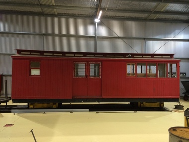
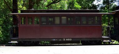
6NBC, Combined Passenger and Guards Van. 2'6" Gauge, 1906
NBC COMBINED SECOND-CLASS PASSENGER CAR AND GUARD'S VAN. Six cars, numbered 1-6, were built during 1898-1905 and originally classed NBDBD. The repeat of the 'BD' lettering in the classification signified that the vehicle was carried on bogie wheels. At the time the letter D was the letter code for Brakevans / Guard's Vans, but this was changed to C when the double-letter code was simplified in 1910. The letter C now being used to describe that a guards compartment was included in the bogie vehicle. On the narrow gauge, the vehicle numbers were retained. A final NBC numbered 7 was added to the fleet in 1910 Between 1926 and 1929 the cars were converted to autocoupler operation. 6NBC Used on the Upper Ferntree Gully, Wangaratta and Colac narrow gauge railways. Withdrawn from service 1951 and used as a workman's hut at Pakenham. Purchased by the Puffing Billy Preservation Society and moved to Menzies Creek in 1959 Utilised as a ticket office and kiosk for the Museum from 1965 to 2010. Service History : NBDBD 6.VA - 26/ 5/1905 NWS Built new - circa 1910 - To NBC 6.VA - *NBC 6.VA - circa 1910 - Reference Photo SL20 p25 /12/1927 - Modified AC Malco BO 19/ 1/1951 - Scrapped Historic - Victorian Railways - Narrow Gauge Rolling Stock - NBC 2nd Class Passenger Car and Guard's VanTimber body (Painted) Steel Chassis (painted) Brass Fittings (Raw) Steel Fittings (Painted)6NBCpuffing billy railway, pbr, 6nbc - victorian railways nbc class combined passenger and guards van. 2'6" gauge -
 Puffing Billy Railway
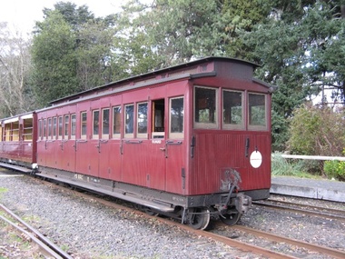
26 NAC - Passenger carriage, 1/ 7/1907
NB Class - Number Built (1st Series) 6 - Number Built (2nd Series) 17 - Number Built (3rd Series) 4 26 NAC - Former NB Class (3rd Series) - Carriage 3 compartments and van (24 pass.) In Active Service - Belgrave Station Yard NAC COMBINED NB PASSENGER CAR AND GUARD'S VAN. A compartment NB which has had a guard's compartment temporarily added in one end. Due to the temporary nature of the guard's compartment, this vehicle retains its number in the NB numbering sequence, but has been classed NAC to differentiate it from the standard NBC. The use of the A is a recognition of the car's original NAB classification. VR Service History NABAB 2.VA - 1/ 7/1907 NWS Built new - circa 1910 - To NAB 2.VA - *NAB 2.VA - circa 1910 - Reference Photo SL20 p20 20/ 8/1923 FTG To NB 26.VA - NB 26.VA - /12/1927 - Modified AC Malco BO 27/ 9/1934 NWS Into Workshops - 30/10/1934 NWS Out of Workshops (34 days) 17/12/1954 - Scrapped Body to Eng. Spcl Works, RS55/707 Purchased by the Puffing Billy Preservation Society as a body & underframe. Historic - Victorian Railways Narrow Gauge - Passenger Rolling Stock: Passsenger carriage Victorian Heritage Register (VHR) Number H2187 The Puffing Billy Rolling Stock Collection Passenger Rolling Stock: 26 NAC - Passenger carriage - Made of Timber on a Wrought iron frame 3 compartments and van (No. 26)26 NAC puffing billy, 26 nac, nac passenger carriage, victorian railways, narrow gauge passenger rolling stock, 2'6" guage -
 Queenscliffe Maritime Museum
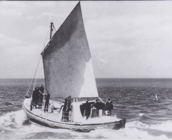
Photograph - Queenscliff Lifeboat under sail, 06 March 1926
The Lifeboat Queenscliffe was built in Adelaide and commenced service at Queenscliff in 1926. She was taken out of service in 1976 by the Marine Board of Victoria and subsequently offered to the Borough of Queenscliffe for care and display. The Lifeboat is listed on the Australian Register of Historic Vessels (ARHV). To view the classification follow the link to the Queenscliffe page on the ARHV site. During her 50 years of service the Queenscliffe attended many calls for assistance both inside and outside the Heads. Some of the vessels and calls for help the lifeboat attended were: 1960 - Army Commandos lost in the Rip 1967 - The search for the late Prime Minister Harold Holt 1974 - The last attendance to a vessel was to the Brisbane Trader which was on fire The shed which housed the lifeboat is located on the Queenscliff 'New' or 'Steamer' Pier (built in 1884). This shed includes the internal section of the slipway used to launch and retrieve the lifeboat. The external slipway and some other structures associated with the lifeboat shed have been removed. Originally fitted with two masts, the stern mast being removed in the 1960's. A retractable centre plate was used when under sail. Delivered with an 80 hp Wayburn petrol motor which was later replaced by a 72 hp Gardiner diesel. Top speed of 7.5 knots and a range of 350 miles.Photograph of lifeboat Queenscliff at sea under sailQueenscliffelifeboat, a. macfarlane & sons -
 Federation University Art Collection
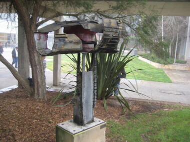
Sculpture - Sculpture - welded Metal, 'Organic Form' by Inge King, c1967
Inge KING (26 November 1915 – 23 April 2016) Born Berlin, Germany Arrived Australia 1951 Inge King trained as a wood carver and studied at the Berlin Academy (1937-1939), Royal Academy London (1940), and the Glascow School of Art (1941-1943) . She moved to London in 1947 and began carving organic abstract forms in wood and stone. In 1949-50 she went on a study tour to the United States of America where she was inspired to work in metal . Inge King arrived in Australia in 1951 and she completed several large scale public works. Between 1961 and 1975 Inge King lectured at the Institute of Early Childhood Development, Kew. From 1976 to 1987 she lectured in Sculpture at Royal Melbourne Institute of Technology. She was a founding member of the Ceminal Centre Five group, and she actively lobbied architects, governments and State galleries to include modernist sculptures in their plans and displays. In 1991 Inge King joined the first National Trust of Australia (Victoria) Public Art Committee, advising on public art at risk and worthy of Trust classification. The Australian Women's Art Register describes Inge King as having been at the forefront of developing a non figurative vocabulary in Australian Sculpture. Welded bronzed steel sculpture painted black and red. This sculpture by Inge King was purchased in 1967 with funds raised by staff and students of Ballarat Teachers' College, a predecessor institution of Federation University Australia. During this era a collection was made which resulted in an annual purchase or commission of an artwork of note. The Federation University Art Collection features over 1000 works and was listed as a 'Ballarat Treasure' in 2007. Signed 'I. King' on the lower steel plate. art, artwork, inge king, king, sculpture, ballarat teachers' college collection, welded metal, metal sculpture -
 Glen Eira Historical Society
Album - Album page, Nithsdale now Five Way Hill, Kambrook Road, Circa 1972
This photograph is part of the Caulfield Historical Album 1972. This album was created in approximately 1972 as part of a project by the Caulfield Historical Society to assist in identifying buildings worthy of preservation. The album is related to a Survey the Caulfield Historical Society developed in collaboration with the National Trust of Australia (Victoria) and Caulfield City Council to identify historic buildings within the City of Caulfield that warranted the protection of a National Trust Classification. Principal photographer thought to be Trevor Hart, member of Caulfield Historical Society. Most photographs were taken between 1966-1972 with a small number of photographs being older and from unknown sources. All photographs are black and white except where stated, with 386 photographs over 198 pages. Glen Eira Heritage Management Plan (1996) by Andrew Ward and Associates - Vol 3 "Nithsdale", built for J.S. Crouchin 1858 and extended in 1885 with a tower and associated rooms, survives as testimony to the nineteenth century occupation of the vicinity of the Kambrook/Glen Eira Road intersection. Caulfield's Building Heritage by Dr Geulah Solomon, Vol 1 p49 records it as a small Victorian mansion home on bluestone foundations of Italianate style with a tower. Built for J S Chambers circa 1860, it was built in stages and then the land subdivided in the 1920s. Other owners include Adolph F Brockhoff (of Brockhoff Biscuits company). Names used besides Nithsdale have been Bundoora and Five Way Hill. Page 102 of Photograph Album with four photographs (three landscape and one portrait) of Nithsdale, now known as Five Way Hill. Three views of the tower and one of the house.Handwritten: "Nithsdale" now "Five Way Hill" Kambrook road [top right] / CNR KAMBROOK AND GLENEIRA ROADS [under bottom right photo] / 102 [bottom right]trevor hart, north caulfield, victorian, mid victorian, late victorian, tower, j.s. crouchin, 1850's, 1880's, italianate, rendered, five way hill, nithsdale, slate roof, plaster arches, ornamental columns, triangular pediment, ornamental parapet, cast iron balconies, kambrook road, glen eira road, t crouch, j s crouchin, mansions, j s chambers, bluestone foundations, land subdivision, adolph f brockhoff, bundoora, house names -
 Glen Eira Historical Society
Album - Album page, Grimwade House, Orrong Road, Circa 1972
This photograph is part of the Caulfield Historical Album 1972. This album was created in approximately 1972 as part of a project by the Caulfield Historical Society to assist in identifying buildings worthy of preservation. The album is related to a Survey the Caulfield Historical Society developed in collaboration with the National Trust of Australia (Victoria) and Caulfield City Council to identify historic buildings within the City of Caulfield that warranted the protection of a National Trust Classification. Principal photographer thought to be Trevor Hart, member of Caulfield Historical Society. Most photographs were taken between 1966-1972 with a small number of photographs being older and from unknown sources. All photographs are black and white except where stated, with 386 photographs over 198 pages. From Victorian Heritage Database citation HO54 Grimwade House, former Harleston stables, outbuilding, garden, gate and Picconia excelsa tree. https://vhd.heritagecouncil.vic.gov.au/places/35573 as at (28/10/2020) ''Harleston'', now "Grimwade House", is situated at no. 67 Balaclava Road, Caulfield North, at the Orrong Road corner. It was built for Frederick, later Sir Frederick, Grimwade, to the design of architect Thomas Watts in 1875. Today the complex has been incorporated in the Melbourne Grammar Junior School campus. It retains not only the main house but also the stables and mature garden setting with driveway and gates. It is historically, aesthetically and socially significant.From Victorian Heritage Database citation HO54 Grimwade House, former Harleston stables, outbuilding, garden, gate and Picconia excelsa tree. https://vhd.heritagecouncil.vic.gov.au/places/35573 as at (28/10/2020) It is historically significant (Criterion A) as the former home of prominent business man, speculator and benefactor, Sir Frederick Grimwade. Both Grimwade and his house are exemplars of the commercial enterprise of the Boom period and the amassing of personal fortunes with which it is associated. It is aesthetically significant (Criterion E) as an imposing yet stately large house of its time, the classic Italian form with comer verandah terminated by projecting wings being most distinctively seen in this instance. It is enhanced not only by the garden setting but also by the delicate cast iron verandah spandrels, stained glass work and stencilled ceiling in the music room. It is socially significant (Criterion G) on account of the value placed on it by the community associated with the Melbourne Grammar Junior School since its inception on this site in 1911.Page 154 of Photograph Album with five photographs (4 landscape and one portrait) including Grimwade House, gates and a tram shelter.Handwritten: Grimwade House (Melbourne Grammar Prep School) / incorporating "Harleston" Orrong Rd. S.E cnr Balaclava Rd [top right] / 154 [bottom right]trevor hart, verandah, porch, slate roof, garden, grimwade house, grimwade, harleston, sir frederick grimwade, thomas watts, orrong road, balaclava road, melbourne grammar, melbourne grammar junior school, italianate, cast iron verandah spandrels, stained glass, stencilled ceiling, mgs, m.g.s, school, grimwade family, jessie grimwade, gates, palisade style fence, cast iron spears, stone plinths, melbourne grammar prep school, victorian style, cast iron work, caulfield north, gardens, cars, tram services, outbuildings, stables, trees, picconia excelsa tree -
 Glen Eira Historical Society
Album - Album page, Glen Eira Road, Circa 1972
This photograph is part of the Caulfield Historical Album 1972. This album was created in approximately 1972 as part of a project by the Caulfield Historical Society to assist in identifying buildings worthy of preservation. The album is related to a Survey the Caulfield Historical Society developed in collaboration with the National Trust of Australia (Victoria) and Caulfield City Council to identify historic buildings within the City of Caulfield that warranted the protection of a National Trust Classification. Principal photographer thought to be Trevor Hart, member of Caulfield Historical Society. Most photographs were taken between 1966-1972 with a small number of photographs being older and from unknown sources. All photographs are black and white except where stated, with 386 photographs over 198 pages. From Glen Eira Heritage Management Plan 1996 by Andrew Ward: Since 1990, valuable historic houses to have been demolished include "Noris", later "Quethiock", and "Koala" (1875) at 34 Balaclava Road, "Urandaline", later Samford private hospital at 510 Glen Eira Road, and No. 9 Lempriere Avenue. When the Caulfield Tramway Company opened its single line horse tramway along Glen Eira Road to Caulfield station in 1889, the eastern end of this road passed through open paddocks and alongside "Urandaline", a charming late Victorian villa residence with comer pinnacle roof, demolished in 1995.Page 59 of Photograph Album with five photographs, one portrait of the exterior of a house on Glen Eira Road, the other four are photos of sections of advertising materials for Urandaline Estate.Hand written: 508 Glen Eira Road [under top left photo] / 58 [bottom left] trevor hart, glen eira road, caulfield north, urandaline, urandaline estate, horse tram, land subdivision, real estate advertising, verandahs -
 Glen Eira Historical Society
Article - Princes Park
This file contains four items. Princes Park information kit (misspelled princess park) compilation (clipped together) of photocopied material about aspects of the park, beginning with Princes Park North East Ground, official report for Glen Eira Council on condition of the park and recommendations for improvements, with blueprints and maps of proposed development. No date but most recent dated page (two letters from Douglas R Aylen, Chief Executive Officer, City of Caulfield, to residents about Princes Park playground is dated 20/05/1991. Includes photocopies of official materials on the purchase of land for the Park beginning in 1920. About sixty pages in all of which several relate to Caulfield Football Club and its campaign for a new pavilion 1967-70. Community News featuring Caulfields Parks and Gardens cutting from Caulfield Contact, 12/1991, on improvements to the park. Photocopy of letter from Rohan Storey Campaigns Coordinator, National Trust of Australia, Victoria to Manager, Planning Section, Glen Eira Council, dated 13/09/2002, headed National Trust Classification of Tree at Princes Park, South Caulfield Quercus suber (cork oak) at Regional level. Includes attached assessment form. Two black and white photocopies of photographs of Princes Park undated from Glen Eira Library Princes Park file, handwritten verso.princes park, parks and resources, glen eira city council, wilson k.d, harris mr, bricker d.c, caulfield football club, victorian football association, princes park trust, evans tim, ladson w.t, dixon r.c, caulfield church of christ, lewis mrs. i.e, caulfield south bowling club, hawkins a.w, briggs j.a, mcdonald s.l, renouf l.s, patience geoff, little ajax football club, gardenvale football club, south east suburban football club, southern metropolitan police football club, caulfield city soccer club, christian brother old boys, caulfield bears cricket club, national trust of australia (victoria), cork oak, tree, storey rohan -
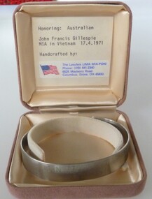 National Vietnam Veterans Museum (NVVM)
Ceremorial Object - MIA Bracelet - L/Cpl John Francis Gillespie, The Laeufers LIMA MIA-POW
The last Australian soldier to be listed as missing in action was Lance Corporal John Francis Gillespie of 8 Field Ambulance. On 17 April 1971 Gillespie was serving as a helicopter medic during a 'dustoff' (helicopter medical evacuation) operation in the Long Hai hills in Phuoc Tuy province. Four South Vietnamese Regional Force soldiers had been injured by a mine explosion and the difficult terrain demanded a helicopter evacuation. But the Long Hai hills were an insecure landing zone. The caves and dense timber of the Long Hais had long harboured a major Viet Cong base area and the dustoff operation required the protection of helicopter gunships. As the first wounded soldier was being winched up, the hovering helicopter was hit by enemy machine-gun fire. It crashed to the ground and burst into flames. Although the crew escaped, Lance Corporal Gillespie and three other soldiers were engulfed in the fireball. A helicopter crewman, Corporal Robert Stephens, repeatedly entered the burning aircraft and tried in vain to rescue Gillespie, until being forced back by the flames. Stephens was later awarded the British Empire Medal for his courage. Gillespie's body could not be recovered from the burning wreckage which was reduced to slag by the fire. Private Gillespie was listed as missing in action, apparently on a technicality because his remains could not be found. The classification was subsequently altered to killed in action.Stainless steel open ended bracelet with missing serviceman's full name and date missing. In a buff square satin lined box.MIA John Francis Gillespie 17/04/71mia, john francis gillespie, l/cpl john francis gillespie, 3170244, royal australian army medical corps, 8th field ambulance, cpl robert stephens, killed in action -
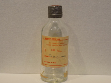 Geoffrey Kaye Museum of Anaesthetic History
Container - Bottle, Blood transfusion
Dr Alan Holmes á Court enlisted in the Australian Army in 1916 as a medical officer with the rank of Captain. In 1918, Holmes á Court was promoted to Major and attached to the 4th Australian Field Ambulance on the Western Front. As the front advanced, the Casualty Clearing Stations became further removed from the battlefield, creating an urgent need for immediate resuscitation prior to transfer back to the CCS. In June 1918, Holmes a Court and his colleagues established a forward resuscitation team. The team consisted of one doctor trained in surgery, blood transfusion and resuscitation, another doctor trained in anaesthesia, resuscitation and blood classification, and four other assisting staff. This team moved out to the wounded, rather than waiting for them to be stretchered back. They provided on-the-spot, life-saving resuscitation. The wounded were then transported back to the Casualty Clearing Station or Regimental Aid Post for further treatment. Among the assorted surgical and resuscitation equipment carried by the forward resuscitation team, were a number of Kimpton-Brown flasks. Blood was collected from patients with minor injuries using the flask. It was then administered to those in need, after establishing their blood type. Citrated blood was introduced by the Americans in 1917. This allowed blood administration to be delayed for up to two hours but there were many problems with transport, storage and infection in these early experimental days.Round, clear glass bottle with white [discoloured] paper label, with red printed, and metal screw-top lid.Handwritten on white [discoloured] paper label: Phillip HARRIS Moulded into the top of the screw-top lid in red ink: RED CROSS BLOOD TRANSFUSION SERVICEblood transfusion, red cross, world war one -
 Melbourne Legacy
Letter, (H3) Early History of Legacy from Legatee Powell, 1928
A letter that was sent from Legatee PW Powell to Legatee 'Doney' on 21st September 1928. He mentions his purpose is to record some of the early history of Legacy in a minute book of the Club, which unfortunately was missing at the time of writing. As well as saying it was formed after Stan Savige saw General Gellibrand's Remembrance Club in Hobart. Luncheon meetings were held and the first one L/ Powell attended in September 1923 had about 8 attendees - Stan Savige, Fred Forrest, Frank Selleck, Charlie Watson, Peter Eller, and Ted Pittard. L/ Powell was appointed Hon. secretary and there was discussion about the name of the club. Suggestions included 'Continuance', 'Chevron', 'Espirit de Corps', and 'Apres Le Guerre'. He says 'at that stage Legacy was not mentioned, the inspiration came later in my own offie when seeking a name that would appeal to he imagination. My recommendation to the members was covered in he first luncheon address given to the Club under the title of "Business Leadership" .' Selection of the first president included inviting General Monash and General Tivey, who both declined. Colonel Harold Cohen accepted. 'The first literature issued by the Club included: List of office bearers (deleting decorations and rank) / Constitution and By laws / Classification / Brief History (which was torn up before issue as it was felt that Legacou should be impersonal and that the principal should stand before the individual).' The notation H3 in red pen shows that it was part of the archive project that was trying to capture the history of Legacy. This is one of the first documents that documents the origins of Legacy.White A4 photocopy of a letter on L/ Powell's letterhead about the early history of Legacy written in 1928.Handwritten H3 in red pen. Signed 'PW Powell' in black fountain point pen. history, founding legatee -
Glen Eira Historical Society
Document - GLEN EIRA ACTIVITY CENTRES
This file contains three items pertaining to the draft of the Glen Eira Activity Centre Strategy, each dated 11/2004 and composed by Peter McNabb and Associates Pty Ltd. (Unknown author of handwritten notes by John Campbell, Mayor of Caulfield 1986-87 and long-time observer of the Caulfield Council/Glen Eira Council): 1/A 53-page Overview Report, summarising the research conducted into the existing state of Glen Eira’s Activity Centres for the purposes of devising a Strategy to improve them. The Report constitutes the first of four components of a broader document termed the ‘Position Paper’, of which the remaining three are not present. The Report is divided into ten sections. The first is an executive summary of the entire document. The second is an introduction that explains the reasons why the Glen Eira City Council chose to embark upon this project. The third describes the methodology by which the research was conducted. The fourth describes what an Activity Centre is defined as. The fifth describes pre-existing policies and strategies pertaining to commercial development. The sixth describes the regional context of Glen Eira’s Activity Centres. The seventh describes the factors affecting Glen Eira’s Activity Centres plus the changes resulting from them, and is divided into four subsections pertaining to demographics, economics, decentralisation and housing, respectively. The eighth describes patterns of activity within Glen Eira’s Activity Centres, containing, for example, tables illustrating the number of particular types of businesses within each Centre. The ninth describes the new classification system for Glen Eira’s Activity Centres, the category each of Glen Eira’s Activity Centres belongs to under this system, and the future roles of each of the Centres. The tenth briefly recaps the entire document. Also included are three colour maps of Glen Eira noting the locations of existing Activity Centres. Handwritten notes and queries feature throughout, but the author thereof is unknown. 2/A 37-page Consultant Report issued for public comment, describing the draft of the Strategy to improve Glen Eira’s Activity Centres that has been formulated based on the data outlined in the Position Paper. The report is divided into six sections. The first is an introduction. The second describes the methodology used to develop the Strategy. The third describes the vision of Glen Eira’s Activity Centres plus the objectives necessary to achieve it. The fourth describes the new classification system for Glen Eira’s Activity Centres, the category that each of Glen Eira’s Activity Centres belongs to under this system, and future roles of each of the Centres. The fifth describes the improvements recommended for the Centres, and is divided into six subsections pertaining to land use, building renovations, street renovations, public transport, traffic plus parking, and marketing plus management, respectively. The sixth, finally, describes the amendment that ought to be made to the Glen Eira Planning Scheme on account of the Overview Report. Also included is a black-and-white map of Glen Eira noting the locations of existing Activity Centres. Again, handwritten notes and queries feature throughout, but the author thereof is unknown. 3/A 3-page summary of the draft, briefly outlining what the strategy is, why it has been prepared, what an Activity Centre is defined as, what the major influences of Glen Eira’s Activity Centres are, how the community has been consulted, what the key findings of the research process have been, what the process from here shall be, and how one can comment on the Strategy. Also included are three colour maps of Glen Eira noting the locations of existing Activity Centres.glen eira, city of glen eira, glen eira activity centre strategy, glen eira activity centres strategy, activity centres, peter mcnabb & associates pty. ltd., peter mcnabb and associates pty. ltd., glen eira city council, glen huntly, ormond, mckinnon, gardenvale, caulfield park, caulfield, murrumbeena, beauville estate, murrumbeena road, oakleigh road, carnegie, neerim road, hewitts road, ormond, koornang road, leila road, north road, caulfield park, kooyong road, gardenvale road, elsternwick, patterson, mckinnon road, bentleigh, alma village, phoenix precinct, parnell street, commercial development, commercial strategy, town planning, melbourne 2030, glen eira planning scheme, local planning policy framework, municipal strategy statement (mss), demography, economics -
 Glen Eira Historical Society
Album - Album page, Normanby Road, Circa 1972
This photograph is part of the Caulfield Historical Album 1972. This album was created in approximately 1972 as part of a project by the Caulfield Historical Society to assist in identifying buildings worthy of preservation. The album is related to a Survey the Caulfield Historical Society developed in collaboration with the National Trust of Australia (Victoria) and Caulfield City Council to identify historic buildings within the City of Caulfield that warranted the protection of a National Trust Classification. Principal photographer thought to be Trevor Hart, member of Caulfield Historical Society. Most photographs were taken between 1966-1972 with a small number of photographs being older and from unknown sources. All photographs are black and white except where stated, with 386 photographs over 198 pages. From: Glen Eira Heritage Management Plan (1996) - Vol 2 by Andrew Ward and Associates The widening of Dandenong Road during the late 1980's has resulted in the destruction of the houses in the path of the roadworks and the construction of a high fence serving as a visual barrier between that thoroughfare and the remaining houses. Where comparatively large villas once stood on spacious allotments, only "Wisteria" survives at No. 135 Normanby Road. Adopting forms and timber enrichment characteristic of the American Queen Anne style, it has this in common with the largely reconstructed timber villa at no. 11 Normanby Avenue and to a lesser extent, 746 Inkerman Road. Normanby Road retains its comparatively opulent Edwardian character in a mature landscaped setting with spacious gardens and mature planes parallel with the railway reserve which, on account of the low lying ground in its vicinity has a high embankment commencing on the alignment of Malvern Grove and continuing to Caulfield Station. The earliest villas are Edwardian. Page 148 of Photograph Album with one landscape photograph of a house on Normanby Road (not Street).Handwritten: Normanby St [top right] / 148 [bottom right]trevor hart, verandah, porch, bull nosed verandah, tower house, tower, stone fence, normanby road, wisteria, american queen anne style, queen anne style, 1890's, mayfield grove, normanby street, timber houses, caulfield north, house names, edwardian, edwardian style, gardens -
 Glen Eira Historical Society
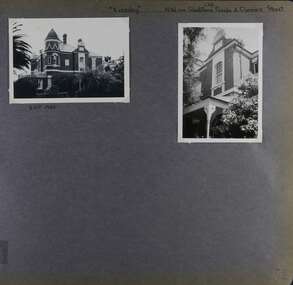
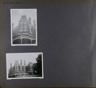
Album - Album page, Eversley, Gladstone Parade & Clarence Street, Circa 1972
This photograph is part of the Caulfield Historical Album 1972. This album was created in approximately 1972 as part of a project by the Caulfield Historical Society to assist in identifying buildings worthy of preservation. The album is related to a Survey the Caulfield Historical Society developed in collaboration with the National Trust of Australia (Victoria) and Caulfield City Council to identify historic buildings within the City of Caulfield that warranted the protection of a National Trust Classification. Principal photographer thought to be Trevor Hart, member of Caulfield Historical Society. Most photographs were taken between 1966-1972 with a small number of photographs being older and from unknown sources. All photographs are black and white except where stated, with 386 photographs over 198 pages. Property now known as Eversley, formerly Nulmore then Brampton. From Caulfield Heritage Management Plan 1996 by Andrew Ward In 1888, C. Hume owned lots 61, 62 and 63 in the Kooyong Park Estate, on the northwest corner of Gladstone Parade and Clarence Street. In 1889 Thomas B. Jackson, architect, of Shoobra Road, purchased the land and in the same year built a ten roomed brick house on lot 63 and part lot 62. Jackson leased the property to William Dalrymple in 1890. By 1894, the property was owned by P. Langwill and leased to James Ainslie, an accountant. By 1899, Frederick Henriques had moved into the house, which was known as ''Nulmore". In 1910, the house was vacant. In 1920, it was leased to Augustine Barbeta who continued to live there in 1930. By 1934, the house was renamed ''Brampton". ''Nulmore" is locally important as an unusually imposing Elizabethan influenced villa in Caulfield, comparing with nos. 34 and 25 Gladstone Parade. Its link with local architect Thomas B Jackson is of interest. Page 52 of Photograph Album with two exterior photographs (one landscape and one portrait) of Eversley , a double storey mansion.Hand written: (36 )[top right] / "Eversley" N.W. cnr Gladstone Parade & Clarence Street [top right] / 8 Oct 1966 [under top left photo] / 52 [bottom right] trevor hart, 1880's, 1890's, gladstone parade, eversley, victorian, clarence street, architectural features, nulmore, brampton, kooyong park estate, architect, shoobra road, hume, elsternwick, double storey mansions, thomas b jackson, william dalrymple, p langwill, james ainslie, frederick henriques, augustine barbeta, elizabethan style, house names -
 Glen Eira Historical Society
Album - Album page, Gladstone Parade, 34, Circa 1972
This photograph is part of the Caulfield Historical Album 1972. This album was created in approximately 1972 as part of a project by the Caulfield Historical Society to assist in identifying buildings worthy of preservation. The album is related to a Survey the Caulfield Historical Society developed in collaboration with the National Trust of Australia (Victoria) and Caulfield City Council to identify historic buildings within the City of Caulfield that warranted the protection of a National Trust Classification. Principal photographer thought to be Trevor Hart, member of Caulfield Historical Society. Most photographs were taken between 1966-1972 with a small number of photographs being older and from unknown sources. All photographs are black and white except where stated, with 386 photographs over 198 pages. From Caulfield Heritage Management Plan 1996 by Andrew Ward In 1889, Thomas B Jackson, an architect in Shoobra Road, owned lots 61-63 at the north west intersection with Clarence Street. He built the two red brick houses, each of 10 rooms, known as "Kenly" and "Nulmore" (later "Brampton") in that year. By 1894, P. Langwill had purchased the property, leasing it to Fred Henriques, an accountant. Alfred Pearson a government chemist, was occupying tenant by 1899. The property was known as ''Kenly''. In 1910, the house was vacant, however, in 1920, James Edmends was living there and continued to do so in 1930. By 1941, Edmends had moved to No. 32, and Alfred Williamson was in residence. "Kenly'' is important as an unusually imposing Elizabethan influenced villa in Caulfield, comparing with nos. 25 and 36 Gladstone Parade. Its importance is enhanced by its substantially intact state whilst its link with local architect Thomas B Jackson is of interest.Page 53 of Photograph Album with two exterior photographs (one portrait and one landscape) of a double storey brick mansion.Hand written: 34 Gladstone Parade [top left] / 53 [bottom left] trevor hart, 1880's, 1890's, gladstone parade, eversley, victorian, double storey, clarence street, architectural features, nulmore, brampton, kooyong park estate, architect, shoobra road, elsternwick, kenly, elizabethan influence, thomas b jackson, p langwill, fred henriques, alfred pearson, james edmends, alfred wiliamson, house names -
 Glen Eira Historical Society
Album - Album page, Glenferrie Street, 4, Circa 1972
This photograph is part of the Caulfield Historical Album 1972. This album was created in approximately 1972 as part of a project by the Caulfield Historical Society to assist in identifying buildings worthy of preservation. The album is related to a Survey the Caulfield Historical Society developed in collaboration with the National Trust of Australia (Victoria) and Caulfield City Council to identify historic buildings within the City of Caulfield that warranted the protection of a National Trust Classification. Principal photographer thought to be Trevor Hart, member of Caulfield Historical Society. Most photographs were taken between 1966-1972 with a small number of photographs being older and from unknown sources. All photographs are black and white except where stated, with 386 photographs over 198 pages. From Glen Eira Heritage Management Plan 1996 by Andrew Ward: In 1905, most of portion 27 was vacant land, however Glenferrie Street had been formed and the land subsequently subdivided. In 1906, Robert Joseph Haddon, architect and painter, designed and built for his private residence, a brick house on the west side. Haddon named the house "Anselm". Also built on the property were a garage and fibro cement studio. "Anselm" is architecturally important at the State level as a substantially intact, highly personalised and boldly expressed house expressive the Arts and Crafts movement and incorporating Art Nouveaux enrichment in a variety of forms, the use of ornamental terra cotta tiles to the comer tower being of special note. Its importance at the State level is strengthened by its place as the home of the noted architect and Melbourne's most influential exponent (Freeland, J.M., Architecture in Australia, p. 213) of the Art Nouveaux movement.https://vhd.heritagecouncil.vic.gov.au/places/4442 Victorian Heritage Register: What is significant? Anselm was designed by noted English born architect Robert Joseph Haddon(1866-1929) as his own house and constructed in 1906. A single storey Arts and Crafts influenced red brick house with attic, Anselm has a pyramidal slate roof with prominent chimney stacks. There is a octagonal corner tower with saucer shaped domed roof surmounted by a weather vane, and the tower has decorative terracotta panels immediately below the eaves line. The front door opens immediately into a large living or common room, screened from view by a timber and bottle glass screen. The large room was designed to function as a drawing and dining room. The house is rich with hand crafted details including door and window furniture, wrought iron gutter brackets, fireplaces (one with built in wood box), and fire tools. The interior decoration includes hand painted frieze of Port Phillip in the study, and a hand painted frieze of turbulent sea with sailing boats in the tiled bathroom. There is a small hand painted tile at the base of the tower which states ?This building was erected AD1906 from designs by Robt J Haddon FRIBA,Lond FRIVA Melb Architect?. He also designed an attic addition which was constructed in 1927. Anselm is substantially intact although the double casement window immediately to the south of the front door was originally circular....Page 60 of Photograph Album with three exterior photographs (one portrait and two landscape) of Anselm.Hand written: 4 Glenferrie Street [top right] / ANSELM 4 Glenferrie St [under top photo] / 60 [bottom right] trevor hart, anselm, art nouveaux, arts and crafts, tower, bay window, glenferrie street, robert joseph haddon, 1900's, terra cotta tiles, double storey, caulfield north, corner tower, gates, cast iron work -
 Glen Eira Historical Society
Album - Album page, Glenferrie Street, 4, Circa 1972
This photograph is part of the Caulfield Historical Album 1972. This album was created in approximately 1972 as part of a project by the Caulfield Historical Society to assist in identifying buildings worthy of preservation. The album is related to a Survey the Caulfield Historical Society developed in collaboration with the National Trust of Australia (Victoria) and Caulfield City Council to identify historic buildings within the City of Caulfield that warranted the protection of a National Trust Classification. Principal photographer thought to be Trevor Hart, member of Caulfield Historical Society. Most photographs were taken between 1966-1972 with a small number of photographs being older and from unknown sources. All photographs are black and white except where stated, with 386 photographs over 198 pages. From Glen Eira Heritage Management Plan 1996 by Andrew Ward: In 1905, most of portion 27 was vacant land, however Glenferrie Street had been formed and the land subsequently subdivided. In 1906, Robert Joseph Haddon, architect and painter, designed and built for his private residence, a brick house on the west side. Haddon named the house "Anselm". Also built on the property were a garage and fibro cement studio. "Anselm" is architecturally important at the State level as a substantially intact, highly personalised and boldly expressed house expressive the Arts and Crafts movement and incorporating Art Nouveaux enrichment in a variety of forms, the use of ornamental terra cotta tiles to the comer tower being of special note. Its importance at the State level is strengthened by its place as the home of the noted architect and Melboume's most influential exponent (Freeland, J.M., Architecture in Australia, p. 213) of the Art Nouveaux movement. Victorian Heritage Register https://vhd.heritagecouncil.vic.gov.au/places/4442 What is significant? Anselm was designed by noted English born architect Robert Joseph Haddon(1866-1929) as his own house and constructed in 1906. A single storey Arts and Crafts influenced red brick house with attic, Anselm has a pyramidal slate roof with prominent chimney stacks. There is a octagonal corner tower with saucer shaped domed roof surmounted by a weather vane, and the tower has decorative terracotta panels immediately below the eaves line. The front door opens immediately into a large living or common room, screened from view by a timber and bottle glass screen. The large room was designed to function as a drawing and dining room. The house is rich with hand crafted details including door and window furniture, wrought iron gutter brackets, fireplaces (one with built in wood box), and fire tools. The interior decoration includes hand painted frieze of Port Phillip in the study, and a hand painted frieze of turbulent sea with sailing boats in the tiled bathroom. There is a small hand painted tile at the base of the tower which states ?This building was erected AD1906 from designs by Robt J Haddon FRIBA,Lond FRIVA Melb Architect?. He also designed an attic addition which was constructed in 1927. Anselm is substantially intact although the double casement window immediately to the south of the front door was originally circular....Page 61 of Photograph Album with one exterior photograph (portrait) of Anselm.Hand written: 61 [bottom left] trevor hart, anselm, art nouveaux, arts and crafts, tower, bay window, glenferrie street, robert joseph haddon, 1900's, terra cotta tiles, double storey, caulfield north, corner tower, brick house, attics -
 Flagstaff Hill Maritime Museum and Village
Functional object - Ship's Fitting, circa 1825
This attractively patinated artefact was raised from the wreck site of the CHILDREN (wrecked January 1839, recovered February 1974) and was quite reasonably catalogued as a portion of a ships porthole. This identification is unlikely however, because the CHILDREN was built at Liverpool in 1824, and round portholes were not in common use until the 1850s. The catalogue identification has since been changed to "Ship's Fitting" Prior to the appearance of round portholes in the middle of the nineteenth century, the function of introducing light to lower decks was performed by square half-glassed ‘ports’ in the side of the hull (known as a port-sash) , or ground-glass ‘bullseyes’ inserted in the deck (scuttles). In historical terms, ports were always square, cut into the timber originally to allow the firing of a ships guns, and were closed in weather by a tight fitting square hatch. Flagstaff Hill Shipwreck Museum has three portholes on display that illustrate the gradual development and adoption of circular brass portholes. First in sequence is a small 12.5cm diameter window (with a deep frame for thick wooden hulls) from the 1855 wreck of SCHOMBERG. The second and third are larger 25cm diameter windows (with a shallower frame for thinner iron hulls) from the 1892 wreck of the NEWFIELD and the 1908 wreck of the FALLS OF HALLADALE . Once the apparently obvious use of the brass object is discounted, an accurate and reliable alternative classification is difficult to specify. One artefact register notes it was ‘found in about the centre of the wreck site’. This would mitigate against the possibilities of (1) ‘horseshoe frame’ joining pieces of the keel and hull at the bow of the vessel, or (2) ‘deckseat’ for a binnacle at the stern. It may support the idea of a ‘head frame’ on a cooped companionway or a ‘deckseat’ for a mainmast pump. But this is only speculation. The actual identification is not known. The wreck of the CHILDREN is of State significance - Victorian Heritage Register S116Ship's fitting, of heavy gauge brass circle, previously classified as section of ship's fitting, which was raised from the wreck of the Children. One end is broken off at an original bolt hole and the other is severed or cut at an acute angle from the inner rim. The artefact is 6cm across and 1cm deep, indicating strength and function as a substantial and finished item of moulded metal. The upper face bears sedimentary accretion stained red/brown. The rear face has been gouged by hard or corrosive materials and bears brilliant blue/green oxidisation.flagstaff hill, warrnambool, shipwrecked-coast, flagstaff-hill, flagstaff-hill-maritime-museum, maritime-museum, shipwreck-coast, flagstaff-hill-maritime-village, the children, brass flange, brass rim, shop fitting -
 Glen Eira Historical Society
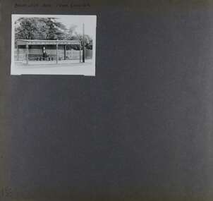
Album - Album page, Balaclava Road Tram Shelter, Circa 1972
This photograph is part of the Caulfield Historical Album 1972. This album was created in approximately 1972 as part of a project by the Caulfield Historical Society to assist in identifying buildings worthy of preservation. The album is related to a Survey the Caulfield Historical Society developed in collaboration with the National Trust of Australia (Victoria) and Caulfield City Council to identify historic buildings within the City of Caulfield that warranted the protection of a National Trust Classification. Principal photographer thought to be Trevor Hart, member of Caulfield Historical Society. Most photographs were taken between 1966-1972 with a small number of photographs being older and from unknown sources. All photographs are black and white except where stated, with 386 photographs over 198 pages. From Victorian Heritage Database citation H0174 TRAM VERANDAH SHELTER CORNER BALACLAVA AND ORRONG ROADS CAULFIELD NORTH - Vic Heritage Register https://vhd.heritagecouncil.vic.gov.au/places/2721 (as at 28/10/2020) The waiting shelter at the corner of Balaclava Road and Orrong Road, Caulfield was constructed in 1916/17 for the Prahran and Malvern Tramways Trust and is one of only three remaining tram shelters in Melbourne designed in the form of a verandah. The shelter has a corrugated iron roof fixed to an angle iron roof frame. The roof, which extends in the form of a skillion over the pavement, is supported on three squared, chamfered timber posts at the rear and three cast iron reeded columns with round bases and Corinthian capitals at the front. (The columns are hollow and function as downpipes, with rainwater discharging from the verandah roof, through the columns and under the ground). The shelter has a rinceau pattern frieze along the road frontage with centrally placed shield motif (which does not contain a coat of arms). The side and rear panels are lined with ripple iron and the upper panel at the rear is lattice work. The shelter has two timber slatted bench seats.From Victorian Heritage Database citation for H0174 TRAM VERANDAH SHELTER CORNER BALACLAVA AND ORRONG ROADS CAULFIELD NORTH - Vic Heritage Register https://vhd.heritagecouncil.vic.gov.au/places/2721 (as at 28/10/2020) How is it significant? The waiting shelter at the corner of Balaclava Road and Orrong Road, Caulfield is of historical and architectural significance to the State of Victoria. Why is it significant? The waiting shelter is of historical significance for its association with the development of the suburban (electric) tram network which assisted the expansion of Melbourne as a suburban metropolis. It is also of historical significance for its connection with the Prahran & Malvern Tramways Trust. The Prahran & Malvern Tramways Trust (1907-1920) was the first municipal electric tramway in Melbourne, becoming the largest and most successful of all the municipal tramway trusts. Its services played a key role in facilitating suburban expansion and the development of the southern and eastern suburbs. The growth of tramways was one of the greatest municipal developments in Victoria during the first decade of the twentieth century. The waiting shelter is an important remnant of this period of Melbourne's transport history and a tangible reminder of the Prahran & Malvern Tramways Trust. The shelter indicates the extent of the Prahran & Malvern tram network. The waiting shelter at corner of Balaclava Road and Orrong Road, Caulfield is one of only three remaining tram shelters in Melbourne designed in the form of a verandah. The waiting shelter is of architectural significance for the distinctive design and construction which is unique to the Prahran & Malvern Tramway Trust tram network. The shelter was designed by notable Melbourne architect Leonard J. Flannagan (1864-1946). Flannagan was responsible for a number of buildings for the Prahran and Malvern Tramways Trust including the early waiting shelter at the junction of Dandenong Road and Hawthorn Road, Caulfield, and sections of the tram depot at Malvern, and also designed a depot for the Hawthorn Tramways Trust. The waiting shelter, a conservative design influenced by Victorian architecture, is based on the Melbourne City Council late 19th century standard cast iron verandah. It is of significance as an intact example of the cast iron type shelter and for its detail, including Corinthian columns and a 'rinceau' pattern cast-iron frieze. The shelter is largely in keeping with the original design and retains its integrity. The cast iron waiting shelter is also of significance as an unusual example of early twentieth century street architecture. Page 155 of Photograph Album with one landscape photograph of a tram shelter on Balaclava Road.Handwritten: BALACLAVA ROAD TRAM SHELTER [top] / 155 [bottom left]trevor hart, verandah, garden, grimwade house, grimwade, orrong road, balaclava road, melbourne grammar, melbourne grammar junior school, mgs, m.g.s, school, tram shelter, waiting shelter, prahran & malvern tramway trust, leonard j. flannagan, cast iron verandah, cast iron type shelter, corinthian columns, 'rinceau' pattern cast-iron frieze, rinceau, cast iron frieze, victorian style, caulfield north, leonard flanagan, cast iron work, prahran and malvern tramways trust, trams -
 Glen Eira Historical Society
Album - Album page, Glen Huntly Road, Circa 1972
This photograph is part of the Caulfield Historical Album 1972. This album was created in approximately 1972 as part of a project by the Caulfield Historical Society to assist in identifying buildings worthy of preservation. The album is related to a Survey the Caulfield Historical Society developed in collaboration with the National Trust of Australia (Victoria) and Caulfield City Council to identify historic buildings within the City of Caulfield that warranted the protection of a National Trust Classification. Principal photographer thought to be Trevor Hart, member of Caulfield Historical Society. Most photographs were taken between 1966-1972 with a small number of photographs being older and from unknown sources. All photographs are black and white except where stated, with 386 photographs over 198 pages. From: Glen Eira Heritage Management Plan (1996) by Andrew Ward and Associates Moore's Buildings", were built in 1891 and comprising 5 shops. In 1888, Hugh Moore, a gentleman, subdivided his land in Glen Huntly Road, north side between Selwyn Street and St Georges Road into 27 lots, with a right of way separating them from his property "Glenmoore". The subdivision was known as the "Glenmoore Estate". Purchases of land included local builders Corkill, French and Pugh. Moore retained five lots and W.W. Jamieson bought lots 11 to 14. "Moore' s Buildings are locally important for their association with the early Elsternwick land owner, Hugh Moore, whose home, "Glenmoore", at 1 St.Georges Road (qv) survives. They recall Elsternwick's role in the Land Boom and survive as a most prominent row in the Glen Huntly Road shops, enhanced by the survival of the unpainted stuccoed surfaces to nos. 307-311. 287-289 Glen Huntly Road: contributory to HO72, Elsternwick Estate and Environs, City of Glen Eira.Page 63 of Photograph Album with one landscape photograph of retail shops (Moore's Buildings).Hand written: 287-289 Glen Huntly Road [under photo] / 63 [bottom left] trevor hart, shop, grocer, stuccoed, terrace, victorian terrace, protruding parapet, ornate render, hugh moore, 1890's, moore's buildings, glenmoore, glenmoore estate, shopping centres, milk bars, cars, victorian style, glen huntly road, glenhuntly road, elsternwick -
 Glen Eira Historical Society
Album - Album page, London Tavern, Hawthorn Road, Circa 1972
This photograph is part of the Caulfield Historical Album 1972. This album was created in approximately 1972 as part of a project by the Caulfield Historical Society to assist in identifying buildings worthy of preservation. The album is related to a Survey the Caulfield Historical Society developed in collaboration with the National Trust of Australia (Victoria) and Caulfield City Council to identify historic buildings within the City of Caulfield that warranted the protection of a National Trust Classification. Principal photographer thought to be Trevor Hart, member of Caulfield Historical Society. Most photographs were taken between 1966-1972 with a small number of photographs being older and from unknown sources. All photographs are black and white except where stated, with 386 photographs over 198 pages. Glen Eira Heritage Management Plan 1996 by Andrew Ward The 1857 rate book indicates that the major portion of the District was under pasture, although a considerable portion was cultivated. There were 159 houses, huts and tents whose occupants were mainly occupied on the land. If "Camden Town" was the principal commercial focus for the District in 1857, it was to remain so in later years, incorporated today in the Glenhuntly Road centre which extends more or less continuously from Elsternwick to Bambra Road. The Caulfield State School of 1877, the horse tramway of 1889 and subsequently the electric trams were all events confirming the importance of Glenhuntly Road and the fledgling community of "Camden Town" wherein the City's commercial centre has its origins. It is recalled, today, by their presence, and also by the "London Tavern" in Hawthorn Road, established by John Guess in 1873. Dr Geulah Solomon's 4 volume book "Caulfield's Heritage" Vol 1 p 93: "A modern hotel presently on the site continues the name of the London Tavern." That was true until recent years as the hotel is named The Camden Hotel now (2021).Page 81 of Photograph Album with one landscape photograph of the front of the London Tavern with handwriting on the edge of the photograph.Hand written: LONDON TAVERN HOTEL 1937 [on bottom edge of photo] / 81 [bottom left] trevor hart, caulfield, hawthorn road, london tavern, camden town, john guess, hotels, pubs, victorian, 1870's, 1930's, sycamore street, the camden hotel -
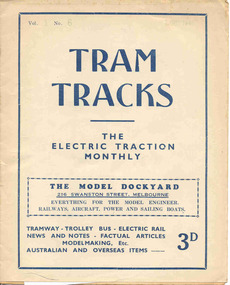 Ballarat Tramway Museum
Magazine, Jack Richardson, "Tram Tracks - The Electric Traction Monthly", Oct to Dec. 1946
Three issues of "Tram Tracks - The Electric Traction Monthly" of the Australian Electric Traction Association. Each issue has a standard cover, of the magazine name etc, with a small advertisement for the Model Dockyard but are in different colours, all have been saddled stapled with two staples. The Volume and date details have been over stamped using a hand stamp. Back covers, inside back covers have the same advertisements. The three issues contain advertisements for Hartleys Sports store, Hearns Hobbies, Wattle Park, Johnson's Variety Store, Barnes Tennis Centre, The Model Dockyard, Meadmore Model Engineering and Austral Bronze Pty Ltd, Christie Scale Model Railway and Equipment, Herbert Small (Meccano) and Bassett-Lowke Models. 2464.1 - Vol. 1, No. 6 - 12 pages, Oct. 1946, with cover printed in blue. Has articles on staff and ticket working on VR tramways, Tramway rolling stock classification, rolling stock listing for SEC Bendigo, and the first 65 years of electric traction. News items on Sydney, Melbourne, Ballarat, Newcastle, Hobart and AETA. Inside front cover has a photo of Y1 611. 2464.2 - Vol. 1, No. 6 - 16 pages, Nov. 1946 with cover printed in brown. Has articles on bus profits, route symbols on Australian tramways, Hobarts double deckers, high current collection tests, rolling stock listing for SEC Geelong, VR Electric locos, and the first 65 years of electric traction continued. News items on Sydney, Melbourne, Ballarat, VR, Brisbane, Adelaide, Perth, Fremantle, Kalgoorlie, overseas and AETA. Inside front cover has photos of Sydney R and R1 class trams. 2464.3 - Vol. 1, No. 7 - 12 pages, Dec. 1946 with cover printed in green. Has articles on NSW tram and bus losses, proposed abandonment of the Sandringham - Block Rock line, Elwood Depot, rolling stock listing of NSW Service stock. Has news items on Brisbane, Sydney, Newcastle, Melbourne, Adelaide and AETA news. trams, tramways, electric traction, aeta, models, australian tramways -
 Glen Eira Historical Society
Album - Album page, Booran Road, 30, Circa 1972
This photograph is part of the Caulfield Historical Album 1972. This album was created in approximately 1972 as part of a project by the Caulfield Historical Society to assist in identifying buildings worthy of preservation. The album is related to a Survey the Caulfield Historical Society developed in collaboration with the National Trust of Australia (Victoria) and Caulfield City Council to identify historic buildings within the City of Caulfield that warranted the protection of a National Trust Classification. Principal photographer thought to be Trevor Hart, member of Caulfield Historical Society. Most photographs were taken between 1966-1972 with a small number of photographs being older and from unknown sources. All photographs are black and white except where stated, with 386 photographs over 198 pages. From Glen Eira Heritage Management Plan 1996 by Andrew Ward: In 1888, John Leek, a trainer, owned Lot 15, measuring one and three quarter acres, in Booran Road, north side between Glen Eira and Neerim Roads. The land backed onto the Caulfield Racecourse Reserve. NAV was £45. In 1890 Leek built for his residence, a ten roomed brick house on the site. NAV was £200. Leek was the owner/trainer of "Ingliston" who won the Caulfield Cup in 1900. Upon the horse's death in 1901, Leek is understood to have defied tradition by spending £20 on boots for the "ragged urchins in Bourke Street" instead of "shouting" at the bar. By 1899, the property was owned and occupied by Alfred Merrill, a dentist and was known as "Andover". NA V had decreased to £ll0. By 1910, Leslie Macdonald, a gentleman had purchased the property and renamed it "Moidart". In 1910-11 Macdonald sold it to John Robertson. The property had extensive wood stables on its north-east boundary and several other outbuildings. The house continued to be described as "Brick, ten rooms" as it was in 1926 when it was owned and occupied by John Arthur, a managing director. The land measured la.2r.31p. and had a NAV of £235. Nine people lived there. In 1926, Arthur also owned the adjoining Lot 16. Other racehorses of note, known to have been stabled here include Sobar, Havelock, Proud, Future and Lord.Victorian Heritage Register https://vhd.heritagecouncil.vic.gov.au/places/13532 What is significant? Lord Lodge is a thoroughbred racehorse training complex adjacent to Caulfield Racecourse, established in 1890. The area immediately around the racecourse has been associated with horse racing activities and businesses servicing the industry since the development of the racecourse in late the 19th century. Lord Lodge was named by the present occupants after the champion racehorse Lord who was stabled there in the 1950s. In the early 20th century the property was known as 'Andover' and subsequently 'Moidart'. The site consists of a single storey brick Italianate villa, jockeys' quarters, stables and open day yards with direct access to Caulfield racecourse from the rear of the property. The villa of 10 rooms on bluestone foundations was constructed in 1890 by John Leek, a horse trainer who purchased the newly subdivided land in 1888. The house has many Victorian Italianate or Boom Style features although it is more modest than many villas of its style. It has an asymmetrical facade with a faceted bay window and a prominent central tower with low pitch pyramidal roof that provides a clear view of the racecourse. Other characteristic features include stilted segmented arches, bracketed eaves, stucco wall finish and cast cement ornamentation. A room has been added on the north-facing verandah in sympathetic style and finish. Internally the rooms are substantially intact with original marble fireplaces and intricate ceiling roses and cornices. An entrance toward the rear of the southern side of the house is said to be where the stable hands, jockeys and other staff lined up for their meals. In the southeast corner of the property, backing directly on to Caulfield racecourse, is a substantial late Victorian timber stable, probably constructed in the 1890s but first appearing on the property title in 1910. The stable has 12 stalls, a loft and brick pavement and jerkin head roof form with varnished pine-lined ceiling carried on a chamfered timber frame. It has an original roof lantern. The doors of the stalls are not the original sliding doors but swing doors obtained from a barn at Epsom Racecourse in Mordialloc prior to demolition. Outside the gambrel roof has fretted barges but the building is otherwise utilitarian. Timber throughout the stalls has been worn by chewing and rubbing of horses over the century of its use. In the southern half of the property are open day yards where the racehorses are kept during the day. The red brick, single storey jockeys' quarters to the rear of the villa were probably built around 1950. A small brick, possibly late Victorian structure on the eastern boundary thought to have originally been a gardening shed, has been converted to a stable of two stalls. Modern concrete brick stables fill the northeast portion of the property. At the front of the property two Moreton Bay Figs (Ficus macrophylla), probably planted in the late 19th century, provide shade for horses in the day yards. In the 1890s John Leek sold the property, relocating his training facility to one of the newly established racecourses at Mentone or Mordialloc (Epsom). By 1899, the property was owned and occupied by Alfred Merrill, a dentist, who named the property 'Andover'. In 1910 it was purchased by Leslie McDonald, a gentleman, and renamed 'Moidart'; sold in 1910-1911 to John Robertson; and again in 1926 to John Arthur, a racehorse owner. The Victorian Amateur Turf Club purchased the property in the late 1930s and since this time has been leased to racehorse trainers. It is unclear whether the property operated as a training facility between 1899 - 1926. Several notable trainers and jockeys are associated with Lord Lodge. The best known is Arthur 'Scobie' Breasley, Australia's most successful jockey who was apprenticed to trainer Pat Quinlan at Lord Lodge (then 'Moidart') from 1928 - 1935. Breasley rode winners of the Caulfield Cup in four successive years 1942-45 and again in 1952. John Leek, the original owner of Lord Lodge trained Ingliston, the 1900 Caulfield Cup winner. Along with 'Lord' a number of well known racehorses including Sobar, Havelock, Proud and Future were trained at Lord Lodge .....Page 40 of Photograph Album with three landscape photographs of the exterior of this house.Handwritten: 30 Booran Road [top right hand corner] / 40 [bottom right]trevor hart, jenny o'donnell, booran road, mansion, caulfield east, ingliston, sobar, havelock, proud, future, lord, andover, moidart, lord lodge, grace darling, caulfield racecourse reserve, victorian amateur turf club, historic buildings register, national estate register, caulfield cup, horses, stables, horse racing, racehorses, outbuildings, racehorse trainers, depression, 1890s, brick houses, mansions, towers, verandahs, stained glass, italianate style, victorian style, architectural features, architectural styles, john leek, leslie macdonald, john arthur, john robertson, alfred merrill, jenny odonnell -
 Puffing Billy Railway
5 NBD, June 1901
NBD This is a Puffing Billy Railway reclassification of the first series of NB carriages. COMBINED NB PASSENGER CAR AND GUARD'S VAN. A saloon or end platform NB which has had a guard's compartment temporarily added in one end. Due to the temporary nature of this conversion, this vehicle also retains its original number in the NB numbering sequence but is classed NBD to differentiate it from the standard NBC and the NAC. The use of the letter 'D' in the classification is recognising the code for guard's vans prior to 1910. NB Class - Number Built (1st Series) 6 - Number Built (2nd Series) 17 - Number Built (3rd Series) 4 NB (1st series) NB 5 was equipped with a vertical hand brake at one end to enable it to be used as the last vehicle of a train. Body Length 20 feet 6 inches ( 6248 mm) Vehicle Length 25 feet 2 inches ( 7671 mm) Coupled Length 27 feet 4 inches (8330 mm) Width 6 feet 3 inches (1905 mm) Height 9 feet 5 inches (2870 mm) Weight 8 tons Capacity 16 passengers Built 1898 - 1904 Number Built 6 In use NBD 1, 2, 5 NB - Puffing Billy Railway classed these as NBD to indicate their use as a trailing vehicle with guard's accommodation. 5 NBD Victorian Railways Service History NBB 5. ( it's original number ) Built new - - / 6/1901 Newport Workshops 4/ 2/1902 - In Service "Commenced running" circa 1910 - renumbered To NB 5 *NB 5. - / 6/1926 - Modified AC Malco 5/ 2/1951 - Scrapped - Body and underframe purchased by Puffing Billy Preservation Society from Pakenham. Restored by the Puffing Billy Preservation Society 1975. In July 2006 work commenced on 5 NB to make it a temporary kitchen car for the luncheon/dinner train. It has had the seating removed from the saloon and kitchen equipment installed. Plans are for a kitchen car to be constructed and 5 NB restored to carry passengers.Historic - Victorian Railways Narrow Gauge - Passenger Rolling Stock: Passenger and Guard's Van carriage 5 NBD - converted into Catering Car and Guards vanMade of Timber and steel 5NBDvictorian railways, narrow gauge rolling stock, 5nbd - catering car and van, puffing billy -
 Puffing Billy Railway
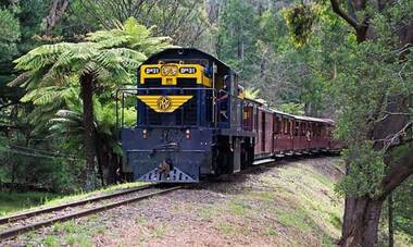
DH59 - Diesel Hydraulic locomotive (formerly DH 31), 1970
DH31 - DH59 Diesel Hydraulic locomotive Built to 3'6" gauge in 1970 this Diesel Hydraulic locomotive entered service for the Queensland Railways where it remained until withdrawn in 1994. Purchased by the E.T.R.B. in 1995, it was converted to 2'6" gauge in Queensland and transported to Belgrave in 1996 for overhaul. It re-entered service later in 1996, although instead of receiving a V.R. type classification & number and V.R. style livery, it retained its Q.R. number of DH59 and its Q.R. livery minus the Q.R. logo, but has since been repainted the traditional Blue & Gold of V.R. diesel locomotives and reclassified DH31. It has since been returned to DH 59. The DH class was a class of diesel-hydraulic locomotives built by Walkers Limited, Maryborough for Queensland Railways between 1966 and 1974. In 1966 Queensland Railways tested a Walkers Limited built diesel-hydraulic shunting locomotive. This was later purchased and by 1974 the 73 DH class locomotives had taken over shunting duties in most Queensland yards. They were also used on short distance freight services. With the closure of many freight yards and the move to longer trains withdrawals started in the 1980s. Many were sold for further use on Queensland sugar cane railways. Locomotive's Queensland Railways Service History : Locomotive : DH59 Serial No: 646 In Service : 19/05/1970 With drawn from Service : 20/05/1991 LOCOMOTIVE DETAILS DH class No. originally constructed : 74 No. in service : 2 No. stored : Wheel arrangement : Bo-BoDH Roadworthy weight : 40T Maximum axle load : 10T Tractive effort (85%) Length overall: 33' Height overall : 12' 6 1⁄2" Driving wheel diameter : 36" Date of manufacture :1970 Manufacturer :Walkers Place of manufacture : Maryborough, Queensland Locomotive type : Diesel Hydraulic DH Class Type Diesel-Hydraulic Introduced 1966 Number in class 73 Manufacturer Walkers Gauge Narrow (QR, MIM) 900mm (SECV) Axles B-B Length 11.1 m Mass 37 t Engine Caterpillar D355E Transmission Voith L42U2 Power 347 kW / 465 HP Tractive effort 114 / 82 kN Speed 50 / 10 km/hHistoric - Queensland Railways - Diesel Hydraulic locomotive DH59DH59 Diesel Hydraulic locomotive made of steel and metalDH59 Diesel Hydraulic locomotivepuffing billy, diesel-hydraulic locomotive, dh59, dh31, walkers diesel hydraulic, queensland railways -
 Glen Eira Historical Society
Album - Album page, Kambrook Road, Circa 1972
This photograph is part of the Caulfield Historical Album 1972. This album was created in approximately 1972 as part of a project by the Caulfield Historical Society to assist in identifying buildings worthy of preservation. The album is related to a Survey the Caulfield Historical Society developed in collaboration with the National Trust of Australia (Victoria) and Caulfield City Council to identify historic buildings within the City of Caulfield that warranted the protection of a National Trust Classification. Principal photographer thought to be Trevor Hart, member of Caulfield Historical Society. Most photographs were taken between 1966-1972 with a small number of photographs being older and from unknown sources. All photographs are black and white except where stated, with 386 photographs over 198 pages. https://vhd.heritagecouncil.vic.gov.au/places/43737 - re 26 Kambrook Road and 345 Balaclava Road corner building: A prominently situated two-storeyed complex of late Victorian buildings consisting of "Wybar's Buildings" occupying the Balaclava Road/ Kambrook Road corner and the "Caulfield Bakery" facing Kambrook Road, separated by a driveway from a single storeyed shop. The main building has a comer splay and balustraded parapet with curved pediments, the words "Wybar's Buildings 1887" having been obliterated but "Caulfield Bakery 1887" with the characteristic wheatsheaf surviving in raised cement work. The walls are stuccoed and richly ornamented with bracketed cornices and keystones with masks extending to the Bakery. The main building is further distinguished by the Masonic symbol of the mason's dividers in the pediment whilst the upper level of the bakery is in overpainted brickwork. The single storeyed shop incorporates the bracketed cornice and consoles characteristic of the main buildings and is in other respects a utilitarian structure. https://vhd.heritagecouncil.vic.gov.au/places/35413 - re 16 Kambrook Road A small late Victorian Italianate villa distinguished by its parapeted window bays either side of a small verandah with encaustic tiled floor. The parapets are balustraded with console enrichment and glazed tiles, the stuccoed surfaces being unpainted. Ornamentation is in other respects undistinguished. https://www.gleneira.vic.gov.au/services/planning-and-building/heritage/heritage-management-plan - re 9-11 Kambrook Road ... they demonstrate most of the commonly employed aesthetic devices characteristic of the Italianate Style including patterned brickwork, patterned slate roofs, cast iron lace verandahs, ornamental stucco work and ashlar boards...https://vhd.heritagecouncil.vic.gov.au/places/43737 - 345 Balaclava and 26 Kambrook Roads HO91 in City of Glen Eira "Wybar's Buildings" at the corner of Balaclava Road and Kambrook Road are important as a prominent late Victorian commercial development incorporating a variety of activities including a bakery and possibly a coffee palace, the latter understood to be unique within the municipality, but characteristic of the period. It is a rare complex of its type in Caulfield and is important also as evocative evidence of the late Victorian Land Boom and the creation of a small now defunct commercial centre at this location by the George Wybrow. https://vhd.heritagecouncil.vic.gov.au/places/35413 - 16 Kambrook Road HO121 in City of Glen Eira ''Hollywood'' at 16 Kambrook Road is of architectural interest for its pavilions which retain their unpainted parapets and ornamental tiles in the manner of other less imposing examples in the immediate locality possibly linked with the builder George Wybar and his son, who undertook substantial projects nearby. Its association with James Yorston, presumably is Yorston of Dickson and Yorston, important builders and estate developers at Caulfield during the Inter war period is of interest. https://www.gleneira.vic.gov.au/services/planning-and-building/heritage/heritage-management-plan - re 9-11 Kambrook Road HO152 Normanby Road/Kambrook Road, Caulfield North Statement of Significance: The Precinct is historically significant for its capacity to demonstrate standards of design and building construction in this part of the municipality during the late Land Boom years and especially just prior to the bank collapse of 1891. The housing stock is representative of the standards of amenity excepted by the middle classes of Melbourne society at the time, including artists, (horse) trainers, jockeys, managers, travellers, journalists and the like, also having a functional link with the activities of the Caulfield Racecourse which forms an important element in the history of the Municipality. The row of attached pairs at 5-11 Kambrook Road and 53-67 Kambrook Road is especially significant in this respect in that the narrow allotments are indicative of the owner/developer’s determination to maximise profits at the height of the Land Boom in 1891...Page 104 of Photograph Album with four photographs (landscape) of three different properties on Kambrook Road.Handwritten: Kambrook Road [top right] / WYBAR'S BUILDING 1887/ INC CAULFIELD BAKERY / [under top right photo] / 16 KAMBROOK ROAD / 1970 HIRST MRS J.N.[under bottom left photo] / 11-9 KAMBROOK ROAD / 1970 9-BUCKLAND MRS L.A / 11- ATKINS MRS N.E. [under bottom right photo] / 104 [bottom right]trevor hart, kambrook road, victorian, caulfield north, parapets, wybar's buildings 1887, caulfield bakery 1887, architectural features, painted bricks, balaclava road, victorian italianate style, houses, bay windows, verandahs, glazed tiles, shops, george wybar, builders, james yorston, dickson and yorston, j n hirst, l a buckland, n e atkins, patterned slate roofs, patterned bricks, cast iron work, attached houses -
 Glen Eira Historical Society
Album - Album page, Kambrook Road, Circa 1972
This page of photographs is part of the Caulfield Historical Album 1972. This album was created in approximately 1972 as part of a project by the Caulfield Historical Society to assist in identifying buildings worthy of preservation. The album is related to a Survey the Caulfield Historical Society developed in collaboration with the National Trust of Australia (Victoria) and Caulfield City Council to identify historic buildings within the City of Caulfield that warranted the protection of a National Trust Classification. Principal photographer thought to be Trevor Hart, member of Caulfield Historical Society. Most photographs were taken between 1966-1972 with a small number of photographs being older and from unknown sources. All photographs are black and white except where stated, with 386 photographs over 198 pages. First 2 images: milkbar and residence corner Kambrook and Balaclava Roads ie south west corner - building named Airdrie 3rd image: https://vhd.heritagecouncil.vic.gov.au/places/43737 - re 26 Kambrook Road and 345 Balaclava Road corner building ie south east corner: A prominently situated two-storeyed complex of late Victorian buildings consisting of "Wybar's Buildings" occupying the Balaclava Road/ Kambrook Road corner and the "Caulfield Bakery" facing Kambrook Road, separated by a driveway from a single storeyed shop. The main building has a comer splay and balustraded parapet with curved pediments, the words "Wybar's Buildings 1887" having been obliterated but "Caulfield Bakery 1887" with the characteristic wheatsheaf surviving in raised cement work. The walls are stuccoed and richly ornamented with bracketed cornices and keystones with masks extending to the Bakery. The main building is further distinguished by the Masonic symbol of the mason's dividers in the pediment whilst the upper level of the bakery is in overpainted brickwork. The single storeyed shop incorporates the bracketed cornice and consoles characteristic of the main buildings and is in other respects a utilitarian structure. 4th image: https://vhd.heritagecouncil.vic.gov.au/places/42415 (on 24/01/2021) - 196 Kambrook Road An imposing late Victorian poly-chrome brick asymmetrical villa with corner verandah and projecting west facing wing with faceted window bay to the facade. Body bricks are red and relieved by cream and black brick banding and by cream bricks to the bracketed eaves. The fretted barge with king post treatment and timber posted verandah are unique in the Municipality and unusual in the metropolitan area and demonstrate an understated appreciation of the emerging Queen Anne mode.345 Balaclava and 26 Kambrook Roads HO91 - City of Glen Eira https://vhd.heritagecouncil.vic.gov.au/places/43737 (on 24/01/2021) "Wybar's Buildings" at the corner of Balaclava Road and Kambrook Road are important as a prominent late Victorian commercial development incorporating a variety of activities including a bakery and possibly a coffee palace, the latter understood to be unique within the municipality, but characteristic of the period. It is a rare complex of its type in Caulfield and is important also as evocative evidence of the late Victorian Land Boom and the creation of a small now defunct commercial centre at this location by the George Wybrow. 196 Kambrook Road HO122 - City of Glen Eira https://vhd.heritagecouncil.vic.gov.au/places/42415 "Glencoe" is situated at no. 196 Kambrook Road, Caulfield North and was built for the boot manufacturer, Robert Bruce Mair, in 1888. It is of historic and aesthetic significance. It is historically significant (Criterion A) as the home of an inner suburban industrialist, notable a boot manufacturer, demonstrating the attraction of Caulfield as a residential location for the manufacturers of the metropolis during the late Victorian Boom period. It is aesthetically significant (Criterion E) as a very early example of a Queen Anne influenced late Victorian villa, comparing at the State level with ''Woodlands'' (1888), North Essendon, generally acknowledged to be one of Australia's earliest houses to fully exploit this emerging style. The ornamental timberwork is especially expressive of the new architectural fashion and compares with the house at 33 Clarence Street, Elsternwick (1888-89).Page 105 of Photograph Album with two photographs of a milk bar and attached residence, one older photograph of Wybar's Building and another photograph of a house on Kambrook Road (all are landscape).Handwritten: 196 KAMBROOK ROAD / 1970 - GAFFNEY MRS S.M. [under bottom right photo] / 100 [bottom left]trevor hart, kambrook road, victorian style, caulfield north, parapets, wybar's buildings 1887, caulfield bakery 1887, architectural features, painted bricks, balaclava road, george wybrow, shops, milk bars, airdrie, polychrome bricks, verandahs, queen anne architectural style, houses, glencoe, robert mair -
 Glen Eira Historical Society
Album - Album page, Labassa Conservatory, 21 Manor Grove, Circa 1972
This photograph is part of the Caulfield Historical Album 1972. This album was created in approximately 1972 as part of a project by the Caulfield Historical Society to assist in identifying buildings worthy of preservation. The album is related to a Survey the Caulfield Historical Society developed in collaboration with the National Trust of Australia (Victoria) and Caulfield City Council to identify historic buildings within the City of Caulfield that warranted the protection of a National Trust Classification. Principal photographer thought to be Trevor Hart, member of Caulfield Historical Society. Most photographs were taken between 1966-1972 with a small number of photographs being older and from unknown sources. All photographs are black and white except where stated, with 386 photographs over 198 pages. WHAT IS SIGNIFICANT? [From Victorian Heritage Database citation for Former Labassa Conservatory - H2005 Victorian Heritage Register http://vhd.heritage.vic.gov.au/places/result_detail/12504 (25/01/2021)] The former Labassa Conservatory is believed to have been built as part of the extensive reworking of the Labassa estate in c1890 for the new owner Alexander Robertson, proprietor of the Cobb and Co line. Robertson commissioned the architect JAB Koch to remodel the house, and Koch may have been responsible for the conservatory as well. Alternatively, the conservatory may have been imported. The gates installed at Labassa in 1890 were manufactured by the MacFarlane foundry of Glasgow, Scotland, a firm known to have manufactured conservatories. Around 1917 the glass house from 'Labassa', Caulfield was offered for sale to Malvern Council for its own gardens but the offer was declined. Following subdivision of the Labassa estate in the 1920s the conservatory was converted into a residence. The structure has a simple rectangular plan, with a brick base and superstructure of cast iron columns and roof trusses. The hipped roof is surmounted by an elaborately decorated gable structure. Most of the original glass has been replaced by metal sheeting. The decoration comprises pressed metal fascias including an egg and dart style cornice moulding, mullion mouldings and gable end panels with a rising sun motif. Cast iron ridgework and finials add to the lively roof form. Internally the floor appears to have been raised as part of the conversion work to a residence, and stained timber panelling introduced to provide room spaces. Boilers probably heated the conservatory in the colder months, but these do not survive.From Victorian Heritage Database citation for Former Labassa Conservatory - H2005 http://vhd.heritage.vic.gov.au/places/result_detail/12504 (25/01/2021) HOW IS IT SIGNIFICANT? The former Labassa Conservatory is of historical and architectural significance to the State of Victoria. WHY IS IT SIGNIFICANT? The former Labassa Conservatory is historically significant for its associations with the Labassa estate. Subdivision of the estate separated a number of outbuildings from the mansion. The former conservatory is significant as part of the large scale improvements carried out to the estate in the 1890s. The nineteenth century was the great age of conservatory designs, enabled by technological developments in heating, glazing and iron. Whilst conservatories were common in botanical gardens and universities, where they were primarily used for cultivating, studying, and experimenting with plants, they had also become an accessory of the wealthy on private estates. The former Labassa conservatory is architecturally significant as a rare example of a building type. Many Victorian mansion houses had attached conservatories, but detached conservatories were much less common. The only other detached example associated with a residence known to survive on its original site in Victoria is an earlier example at Warrock homestead, near Casterton. Conservatories attached to nineteenth century mansions are far more numerous. The Labassa example is very ornate, and its decoration draws on the versatility of pressed metal and cast iron. This highlights the dual purpose of the conservatory, as both a functional structure and a picturesque building on the Labassa estate. This building is unusual as an example converted to residential use. Page 130 of Photograph Album with one portrait photograph of Labassa's conservatory.Handwritten: "Labassa" conservatory 21 Manor Grove [top right] /130 [bottom right]bracketed eaves, caulfield north, labassa, balaclava road, orrong road, sylliott hill, alexander william robertson, ontario, john a. b. koch, john boyd watson, mouldings, 1920's, la bassa, manor grove, st kilda east, architects, john koch, greenhouses, gardens, plants, land subdivisions, gates, macfarlane foundry, brick, cast iron work, hipped roofs, gables, 1890's -
 Glen Eira Historical Society
Album - Album page, Old Fire Station, 4 Selwyn Street, Circa 1972
This album was created in approximately 1972 as part of a project by the Caulfield Historical Society to assist in identifying buildings worthy of preservation. The album is related to a Survey the Caulfield Historical Society developed in collaboration with the National Trust of Australia (Victoria) and Caulfield City Council to identify historic buildings within the City of Caulfield that warranted the protection of a National Trust Classification. Principal photographer thought to be Trevor Hart, member of Caulfield Historical Society. Most photographs were taken between 1966-1972 with a small number of photographs being older and from unknown sources. All photographs are black and white except where stated, with 386 photographs over 198 pages. From Victorian Heritage Database citation for H2376 Former Elsternwick Fire Station, 2-4 Selwyn Street Elsternwick - Victorian Heritage Register https://vhd.heritagecouncil.vic.gov.au/places/2645 (as at 21/11/2021) The Former Elsternwick Fire Station was built and commenced operation in 1896. It was one of 32 new fire stations built between 1892 and 1896 by the newly formed Melbourne Metropolitan Fire Brigade ('MFB') to form a comprehensive fire-fighting network across Melbourne. The MFB was established in 1891 as Victoria's government-run fire-fighting service in Melbourne and its growing suburbs. By 1918 motorised fire engine appliances had replaced horse-drawn fire vehicles across the metropolitan area, and the consequently larger areas that fire stations could protect meant the 1896 Elsternwick Fire Station was one of many which was becoming obsolete. The MFB continued to use the Elsternwick Fire Station up until the Station's closure in 1926. From 1927 the former Fire Station was leased by neighbouring timber merchants JJ Webster Pty Ltd who subsequently purchased the property from the MFB in 1934. From 1954 the 'Esquire Motors' car repair business traded at the site, and changes to the former Fire Station building including the complete enclosure of its yard by corrugated steel walls and roofing appear to have been completed in the mid-1950s. In 1990 the Australian Broadcasting Corporation ('ABC') purchased the former Fire Station together with five other adjoining land parcels in Selwyn Street. From that time until 2017 the former Elsternwick Fire Station has been used by the ABC as office and storage space in its Selwyn Street television studio complex.From Victorian Heritage Database citation for H2376 Former Elsternwick Fire Station, 2-4 Selwyn Street Elsternwick - Victorian Heritage Register https://vhd.heritagecouncil.vic.gov.au/places/2645 (as at 21/11/2021) The Former Elsternwick Fire Station is historically significant as one of the 10 remaining fire stations of the original 32 built for the newly established Melbourne Metropolitan Fire Brigade ('MFB') during the four-year period 1892 to 1896. These fire stations were constructed following the establishment in 1891 of the MFB, Victoria's government-run fire-fighting service for metropolitan Melbourne and its growing suburban population. These new stations formed a crucial part of the MFB's fire-fighting network across Melbourne. The Former Elsternwick Fire Station clearly demonstrates the historical development of fire-fighting services in Melbourne, especially the expansion of the newly-formed MFB throughout Melbourne's suburbs during the 1890s. [Criterion A] The Former Elsternwick Fire Station is architecturally significant as a fine example of a late nineteenth century fire station. Constructed shortly after the establishment of the MFB, it displays characteristics of its class of place that remain mostly unchanged from the former Station's historically important period of development and use. A particularly strong element of the Former Elsternwick Fire Station is the large and strikingly-detailed stone horseshoe arch, designed for horse-drawn fire-fighting vehicles, at the street entrance to its fire-engine room. [Criterion D]Page 188 of Photograph Album with two photographs of the old Elsternwick Fire Station.Handwritten: old fire station 4 Selwyn Street [top right] / 188 [bottom right]trevor hart, rendered, 1890's, melbourne metropolitan fire brigade, mfb, fire-fighting, jj webster, timber merchants, esquire motors, car repair, australian broadcasting corporation, abc, selwyn street, brick and stone, asymmetrical facade, anglo-dutch gable, rusticated and smooth-faced limestone, elsternwick fire station, elsternwick, fire station, jj webster pty ltd, motor vehicle repair shops, stone horseshoe arch entrance -
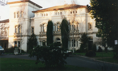 The Beechworth Burke Museum
Photograph, c.2000
This photograph was captured on an undisclosed date and by an unidentified photographer. It was printed in colour through the company AGFA which is a Belgian-German Multinational Corporation. This business prints, develops, manufactures and distributes digital imaging products, software and systems. It was founded in 1967 and continues to operate today. Beechworth's Mayday Hills was chosen as the site of Victoria's newest asylum, at the time, due to the landscape and altitude. The hilltop atmosphere and the native fauna, it was argued, would assist in the cure of the patients kept at the hospital (Wood 1985, 122). The positioning of the hospital had a beneficial effect on the rural town. A pamphlet published by James Ingram and Son (1849) reveal that famous landmarks in Beechworth which included the Post Office, Gaol, Courthouse and Asylum "demonstrate the appreciation of Beechworth by the Government not only as as important district center, but also as a site unrivaled as a sanitarium". There were other locations in contention at the time, but ultimately Beechworth was chosen (Craig 2000, 33). Prior to the creation of the Asylum in Beechworth, those charged with having mental illnesses or, as it was termed, "insanity" were unable to be properly cared for in the Gaol (which is where they were often sent). John Buckley Castieau wrote, in 1861 for the Ovens and Murray Advertiser, that the Gaol was unable to properly care for those classified then as "insane" but that they would endeavor to treat them above the other inmates (which he notes is not always the case in other establishments). Castieau wrote this in favour of supporting the building of the Mayday Hills Hospital in Beechworth. It was stated that at the time the Mayday Hills Hospital was built, there were 83 prisoners kept in the Gaol who were to be rehoused to the Hospital on the grounds of "insanity". The classification as someone as "insane", in this period of time is a reflection on the inability to cure and understand illnesses of the mind during the mid to late 1800s. Opening on the 24th of October 1867, the Mayday Hills Hospital was originally named the "Ovens Lunatic Asylum", a title which is very much a product of its time. Whilst controversial, changes to the name is part of the history of the Hospital and can provide much insight into the understanding of mental illness throughout history and the use/disuse of this term provides information into the reception/changing opinions of mental illness in society. The Hospital would later become known as the "Mayday Hills Asylum" and/or "Mayday Hills Hospital" with the latter being the most commonly used title. An article in the Ovens and Murray Advertiser notes that on the 7th of March 1865, the foundation stone of the Hospital was laid (it would officially open in 1867) and that it was such a moment of accomplishment and joy for Beechworth that a letter to the editor even suggested that there should be a holiday dedicated to the day the foundation stone as laid. This reveals an extent to which the townspeople of early Beechworth valued the construction of the Hospital in their town. It provided the town with a sense of prestige and honour.At first glance, the remains of the Mayday Hills Hospital in Beechworth, Victoria, inspire tragedy, trauma and beauty. The buildings themselves, with their Italianate style Renaissance architecture designed by J.J. Clark (Craig 2000, 49 & Smith 2016, 203) reflect a bygone period of European and Australian history. The gardens provide a sense of tranquility and beauty. The experience of those within these walls remains a valuable area of study to provide a more complete understanding. This particular hospital is considered the fourth of its like and one of three identified as the largest of their kind. The Mayday Hills Hospital is a sister to the Kew and Ararat Asylums in Melbourne which are both located in relative proximity. Understanding the role of the Mayday Hills Hospital in Beechworth history is integral to understanding the development of the goldfields town, but also for providing important information as to the history of caring for, and the reception of, mental illnesses in Australian and wider European history. Mayday Hills provides a case study which can be researched through oral history, an analysis of the grounds/buildings and through images like this postcard which portray the structure in a highly deliberate manner. Images like this depict the strong façade of the Hospital and provide a glimpse into the tranquility of the gardens. This has been done deliberately to provide a sense of comfort and healing about the building to those looking from the outside. Further research into the importance of the Hospital in Beechworth and it's connection to the town will be supported through images like these kept in the Mayday Hills photo album in the collection of the Burke Museum.Coloured rectangular photograph printed on gloss photographic paper.Reverse: AGFAbeechworth, mayday hills, mayday hills asylum, mental health, history of mental health, asylum, 1860s, gold town, north-east victoria, kew asylum, ararat asylum