Showing 1032 items
matching water river
-
 Warrnambool and District Historical Society Inc.
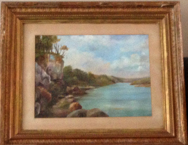
Painting, Hopkins River - Mary Norman - Clifton Banks
Clifton Banks is the name given to a bank on the Hopkins River Estuary, about one kilometre upstream from Proudfoots Boathouse. It is at the foot of the property, Clifton, which dates from 1850s. There are several works of art and photographs of Clifton Banks dating from the late 19th and early 20th centuries. Mary Norman (later known as Mary Norman=Bail) came to Warrnambool in 1901, residing with Canon and Mrs McGeorge. She studied art with Samuel Pearce Fuller and later taught art at Fuller's studio and at a local private school. She produced several seascapes and landscapes while she was in Warrnambool, leaving the town in 1905. She devoted the rest of her life to art as an artist and teacher. In 1922 she married Jess Bail. This art work of Clifton Banks won first prize at the 1902 Annual Ararat Art competitions. It was reported at the time that the work was not a copy but had been drawn from nature. The Warrnambool and District Historical Society has five of Mary Norman-Bail's art work.This is a most significant item as it is one of Mary Norman's art works and she was known in the early 20th century as a competent artist and a member of the Victorian Artists' Society. This art work also has historical significance as one of a number of Clifton Banks representations still surviving. Mary Norman also had an impact on the cultural life of Warrnambool during her short stay in the town. She also returned to teach in the town several times for short periods during the summer vacation times.This is a water colour mounted on art board and with a gilt framed and three outer layers of wooden gilded ornamental frames. The sides of the frames are broken in places and the guided material is somewhat discoloured. There are Les O'Callaghan handwritten notes and some typed material on the back giving information on Mary Norman and the art work. The back is sealed with pasted paper and there are both string and wire attached for hanging the pictureBack of art work: 'Diamond Bros, Photo Enlargers, Importers of Mouldings, Mounting Boards, Albums, Mirrors etc, Picture Framers. Mount Cutters and Plush Workers, Studio - 27 Bridge Road, Melbourne, Factory- 45 and 47 Duke Street, Richmond, Armstrong Street, Ballarat, Pirie Street, Adelaide, Brisbane, & Freemantle W.A.'mary norman, clifton banks, warrnambool -
 Warrnambool and District Historical Society Inc.
Financial record - Ledger: Warrnambool Water works Trust, Circa 1900
This ledger contains entries which relate to waterworks and associated expenses: construction, pumping schemes, water from stand pipes, meter rent arrears, interest payments, pumping scheme. Early residents in Warrnambool relied on tanks and wells for their water supply and in 1880 the first water supply scheme was implemented from a well on Cannon Hill. Using a windmill the water was pumped up and stored in a small reservoir nearby then piped to the corner of Timor and Liebig Streets where a stand pipe allowed the filling of water carts. Similar supplies were also installed at Albert Park, the Botanic Gardens and the Cattle markets and from 1893 to 1939 water was drawn from the Merri River. Drainage works commenced with the building of the Japan Street tunnel in 1856. The Warrnambool Waterworks Trust was the body responsible for administering these works.The supply and storage of fresh water and drainage of the area was an important factor in the development and sustainability of the town. This ledger provides an insight into the daily operations of this organisation. Large suede covered journal. Tan in colour with pink, green and white on edge of pages. Faded black stylised border around front cover. Inside front covers are patterned in green and tan. Printed sheet with Warrnambool waterworks Trust is pasted inside front cover. Warrnambool Waterworks Trust stamp on sheet inside front cover.warrnambool water works, warrnambool water supply 1900, warrnambool water works ledger 1900, warrnambool waterworks trust -
 Warrnambool and District Historical Society Inc.
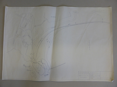
Map, Soil conservation authority:plan of high water marks at Lady Bay Warrnambool, 1984
This map documents the changing state of Lady Bay from around 1870 until 1976. It depicts the changing high water mark over that period and the main outlet of the Merri River in 1872 and 1976.This map provides a useful and significant insight into the ever changing face of Lady Bay from the 1870’s through to 1980’s. Cream paper map drawn with black ink showing Lady Bay and South Warrnambool section of Warrnambool. In lower RH corner Soil conservation AuthorityPlan of High water marks at Lady Bay Warrnambool. Drawn P.D. 19.1/84. Scale 1:3600. Written on back in black pencil: Lady Bay Historical HWM lady bay map, merri river 1872- 1976, merri river 1872- 1976, history of warrnambool -
 Warrnambool and District Historical Society Inc.
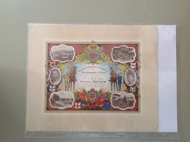
Certificate - Royal Review 1901 G Rolfe, 1901
This certificate was sent to those who had been present at one of the celebrations in connection with the Federation of the six States of Australia in 1901 – The Royal Review at Flemington Racecourse on 10th May 1901. The invitation to attend the event was issued by the Government of Victoria. The certificate was intended to be kept as a souvenir of the event and framed. This particular certificate was issued to George Rolfe and his wife of Warrnambool. George Rolfe (1836-1919), a tea merchant from Melbourne, began buying blocks of land near the mouth of the Hopkins River in Warrnambool in the 1870s. By the early 1880s he had acquired 50 acres of land in the town and several farming properties. He used the buildings on the land near the mouth of the Hopkins River as holiday accommodation and called the property, Lyndoch. He improved the property by adding stables, chaff and bone sheds, jetty, boathouse, reservoir, water well and windmill and extensive gardens and he spent most of his later life in the Warrnambool area. Lyndoch today is the site of an aged care facility. This certificate is of considerable importance for two reasons: 1. It is an important memento of a signal event on Australia’s history – the Federation of the six States in 1901 and the subsequent celebrations. 2. The certificate was issued to a prominent Warrnambool person, George Rolfe and his wife.This is multi-coloured sheet of paper mounted on card. There are four black and white photographs of the Royal Review at Flemington and photographs of the Duke and Duchess of Cornwall and York. The images include the Royal Crest, the shields of the six Australian States, a shield of Victoria with a background of flags, cannon and ammunition, two mounted soldiers with a soldier and sailor standing nearby and swords and bayonets. There is also much colour decoration around the edges of the certificate. The names of Mr and Mrs Rolfe are handwritten in black ink. ‘Australian Commonwealth Celebrations’ ‘The Government of Victoria requests the honour of the presence of Mr & Mrs G. Rolfe at the Royal Review at Flemington on Friday the 10th of May 1901’ federation of australian states, george rolfe of lyndoch, history of warrnambool, george rolfe -
 Warrnambool and District Historical Society Inc.
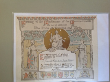
Certificate - Invitation to the opening of the Parliament of the Commonwealth of Australia, 1900
This certificate is an invitation to the opening of the first Parliament of Australia on January 1st 1901 in Melbourne. On this date the six Australian self-governing colonies were federated to become the six states of Australia. The designers of the certificate were Norman Lindsay and John Longstaff. This particular invitation was sent to George Rolfe and his wife and two of his stepdaughters, Annie and Florence. George Rolfe (1836-1919), a tea merchant from Melbourne, began buying blocks of land near the mouth of the Hopkins River in Warrnambool in the 1870s. By the early 1880s Rolfe owned 50 acres in the town, including farming properties and used the buildings near the mouth of the Hopkins as holiday accommodation. He called his property Lyndoch which he improved with the addition of stables, chaff and bone sheds, jetty, boathouse, reservoir, water well and windmill and extensive gardens and he spent most of his later life in this Warrnambool area. Lyndoch today is the site of an aged care facility. This certificate is of considerable importance for two reasons: 1. It is an important memento of a signal event in Australia’s history - the Federation of the States in 1901. 2. The certificate was an invitation to the family of a prominent Warrnambool person – George Rolfe of Lyndoch.This is a piece of thick paper with illustrations and decorations in brown, red, blue, yellow and green tonings. The lettering is in white with coloured capital letters. The images include the shields of the six Australian States, the Coat of Arms of Britain and Australia, outlines of two trees (gum tree and oak tree) and three symbolic female figures representing Justice, Britannia and Australia. The top border decoration represents the waratah flower. The names of the invitees on this certificate have been handwritten in black ink. ‘Opening of the Parliament of the Commonwealth by His Royal Highness The Duke of Cornwall and York’ ‘Mr G and Mrs Rolfe and the Misses Rolfe (2)’ george rolfe of lyndoch, federation of australia, history of warrnambool, george rolfe, opening of first parliament of australia -
 Warrnambool and District Historical Society Inc.
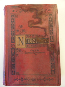
Book, No cross no crown
This book has been given by the Woodford Sunday School to Edith Cassady (note the misspelling of ‘Cassady’). Edith Cassady was the daughter of William and Elizabeth who lived at Boughton on the Merri River (near Cassady’s Bridge, Caramut Road today). This property was established about 1845. The donor of the book was William Wines, a member of a pioneering family in the Woodford district. This book is of some interest as it belonged to Edith Cassady, a member of a pioneering family who lived at Boughton on the Merri River. This is a hard cover book of 344 pages. The cover is red with black border decorations and black and gold lettering. There are several full page black and white illustrations scattered throughout the book which has 23 chapters of story. The cover and pages are much water-stained. The inscription is handwritten in black ink. ‘Woodford Sunday School Presented to Edith Cassidy (sic) by her well-wisher William Wines’ william wines, woodford, history of woodford, edith cassady, boughton property, cassady family -
 Warrnambool and District Historical Society Inc.
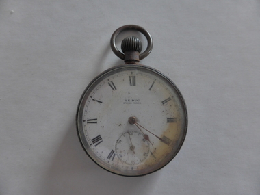
Watch, Watch from Nestor
This watch belonged to Norman Borthwick of Ecklin, who, with his wife and two children, Janet, aged 7 and Jack, aged 6, were survivors of the sinking of the cruise boat, Nestor, on the Hopkins River in January 1921. The boat was on its regular trip from the Hopkins River boatsheds to Jubilee Park with 80 passengers. Ten people were drowned when the boat began to take water and sank about a kilometre upstream. Norman Borthwick was wearing the watch at the time and the hands have stopped at 5.20 p.m. on the day of the tragedy. A hero of the day was Constable Sharrock who drowned after saving the lives of several of those on boardThis watch is of great significance as it is an item that belonged to Norman Borthwick who was wearing the watch when he survived the sinking of the Nestor in the Hopkins River in 1921. This was one of the great tragic incidents in Warrnambool in the early 20th centuryThis is a Swiss-made watch made of gunmetal with a glass face and a metal winder at the top and a ring to attach the watch to a chain. The figures are Roman numerals and there is a separate minute hand dial. The watch is much rusted and is not able to be easily opened to see the mechanism. The gold-coloured hands point to the time of 20 past 5. The face of the watch is discoloured on the right hand side.‘Le Duc, Swiss made’nestor sinking, norman borthwick, constable sharrock -
 Warrnambool and District Historical Society Inc.
Book, Cuckoo of the lof raft - Bessie Marchant, Early 1930s
This book was given in 1941 as a prize to Shirley MacDonald from the South Warrnambool Sunday School. This Sunday School was operated by the South Warrnambool Presbyterian Church and existed from 1902 to 2004. The church was in MacDonald Street which was named after John MacDonald, an early teacher and auctioneer in Warrnambool but no details have been found on Shirley MacDonald. This book is of interest as a memento from the South Warrnambool Sunday School and as an example of the type of book given as prizes to young girls in Warrnambool during World War Two. This is a hard cover book of 256 pages. The cover is red with black lettering and the there is a dust cover partly pasted onto the hard cover. The dust cover is multi-coloured with an image of a river scene (man in trouble in the water with a woman trying to help him) on the front and a horse and rider on the spine. The lettering on the dust cover is in yellow and dark blue tonings. The book has become detached from the pages at the back. The inscription is handwritten in blue ink on a printed book plate pasted on to the inside front cover. There is a black and white full page illustration at the front of the book ‘Xmas 1941 Awarded to Shirley MacDonald, Sth Warrnambool Sunday School’ south warrnambool sunday school, shirley macdonald, history of warrnambool -
 Kiewa Valley Historical Society
Photo - Junction Dam Diversion Tunnel
Junction (Lake Guy) Dam is a 'slab and buttress' type wall. A timber frame is built and then filled with concrete. The first batch of concrete was placed in September, 1940. By June, 1941 the buttresses were finished to a height safe from floods and in October of that year a flood of 2,800 cusecs occurred but with only slight damage to the installations. Industrial trouble caused some delays but there was also slow progress on the part of the contractor and the work was taken over by the S.E.C., terminating the contract. The dam was completed in March, 1944. A walkway was made through the dam wall. Lake Guy was named after Mr. L.T. Guy who was the Resident engineer, in charge of construction work and associated activities on the Kiewa Area from 1939 to November 1946.Diversion dams are installed to raise the water level of a body of water to be redirected. The redirected water is used for hydro electric power generation. A diversion tunnel is usually bored through solid rock next to the dam site to bypass the dam construction site. The dam is built while the river flows through the diversion tunnel.Photos of the construction of the Junction Dam detail the harsh conditions faced by construction workers, building dams and villages to accommodate workers in the 1940s to the 1950s. Australia at this period in time, experienced a surge of population (influx of World War II refugees), which was the catalyst for developing and undergoing an enormous hydroelectricity program for the Alpine regions, both in Victoria and New South Wales. This program was initiated to supply electricity to the major southern Australian cities of Adelaide, Melbourne and Sydney. It was thought that these developments would reduce, if not eliminate, the requirement for coal driven power stations. However time has demonstrated that these power stations have not matched the demand required by the industries and the populations of the major urban and cities.Black and white photograph of Junction Dam diversion tunnel at Bogong VillageHandwritten on back - Junction Dam Diversional Tunnelbogong, secv, junction dam, lake guy -
 Kiewa Valley Historical Society
Photograph - Mt Beauty Camp, Estimated 1950-1951
This photo is of the very newly constructed State Electricity Commission town of Mt. Beauty. The houses up to Nelse street were erected from 1946 onward and then the township was extended beyond Nelse Street in 1950 which places this photograph about 1950/51. There is no evidence of work being commenced on the regulating pondage but the tail race canal can be seen on the centre right of photo. The workmen's camp was enlarged in 1950 to the extent of providing accommodation for a total of 1,200. There are a number of dwellings on Simmonds Creek and the road to Falls Creek can clearly be seen. Snow capped Mt. Bogong is in the upper left of the photo with Mt. Beauty behind the township rising to Big Hill beyond that.Shows the newly constructed town of Mt. Beauty surrounded by farmland and before the regulating pondage was built to discharge water from the power stations via the West Kiewa tail race tunnel into the Kiewa River. Copy of black and white photograph of Mt Beauty CampWritten on the back in black ink - A Campenmt beauty camp, secv, construction town -
 Kiewa Valley Historical Society
Photograph - Kiewa River in flood at Clover Dam
As part of the push to cut electricity costs and diversify supply, the Victorian Government (circa 1930) implemented the conversion strategy from mainly brown coal supply to hydro - electricity. The Kiewa Hydroelectric Scheme became the largest scheme of its kind in the State Of Victoria and the second largest scheme in Australia. Clover Dam and Power Station were built by the State Electricity Commission of Victoria as part of the Kiewa Hydro Electric Scheme from the late 1930's to the early 1940's. This dam was constructed to supply water to feed four turbines (62 mega watts) at the West Kiewa Power Station. This was at the forefront of sustainable "Green" energy. Costs associated with power supplies is still a major incentive of governments, however environmentally friendly alternatives such as wind and nuclear have also made inroads. The Kiewa valley and its surrounding alpine catchment were looked at(Victorian State Government), from the beginning of the twentieth century as a source of alternate power for an ever-increasing demand for electricity by growing population and heavy industrial areas within Melbourne City and State regions. Construction of dams, such as Clover Dam provided the large quantity holding areas of water required to turn the turbines at the various power stations to provide the electricity needed. The impact of these controls by moderating water run-off from the alpine regions is beneficial in reducing flooding from thawing of snow on the alps. This by-product allows agriculture and grazing to be less vulnerable to seasonal flooding thereby resulting in a more stable annual production level.Black and white photograph of Clover Dam with Kiewa River in flood. .5mm white boarder on 3 sides of photo.Handwritten on back of photograph in black pen - Kiewa in flood. Clover Dam.clover dam, secv -
 Kiewa Valley Historical Society
Photograph - Clover Dam
As part of the push to cut electricity costs and diversify supply, the Victorian Government (circa 1930) implemented the conversion strategy from mainly brown coal supply to hydro - electricity. The Kiewa Hydroelectric Scheme became the largest scheme of its kind in the State Of Victoria and the second largest scheme in Australia. Clover Dam and Power Station were built by the State Electricity Commission of Victoria as part of the Kiewa Hydro Electric Scheme from the late 1930's to the early 1940's. This dam was constructed to supply water to feed four turbines (62 mega watts) at the West Kiewa Power Station. This was at the forefront of sustainable "Green" energy. Costs associated with power supplies is still a major incentive of governments, however environmentally friendly alternatives such as wind and nuclear have also made inroads. The Kiewa valley and its surrounding alpine catchment were looked at(Victorian State Government), from the beginning of the twentieth century as a source of alternate power for an ever-increasing demand for electricity by growing population and heavy industrial areas within Melbourne City and State regions. Construction of dams, such as Clover Dam provided the large quantity holding areas of water required to turn the turbines at the various power stations to provide the electricity needed. The impact of these controls by moderating water run-off from the alpine regions is beneficial in reducing flooding from thawing of snow on the alps. This by-product allows agriculture and grazing to be less vulnerable to seasonal flooding thereby resulting in a more stable annual production level.Black and white photograph of Clover Dam buildings and Kiewa River. Has a .4cm white border around photograph Printed on bottom left corner of photograph in white - Clover Flatclover dam, secv -
 Kiewa Valley Historical Society
Photographs x 2- Khancoban Station and Comet the horse
In 1824, Hume and Hovell were the first Europeans to pass through the district and graziers soon followed, impressed by the abundance of fodder and water. The first cattle run in the area was settled in about 1838 in what was known as Swampy Plains. Later, this run became known as “Khancoban Station”. Khancoban lies in the heart of the high country and is home of Australia’s mountain cattlemen. This heritage is celebrated in Banjo Paterson’s epic poem, “The Man from Snowy River”. In 1962, Bruce and Jo Chisholm relocated from Bond Springs to Khancoban Station, which Bruce had acquired in 1959. Khancoban Hereford and thoroughbred stud progeny were keenly sought after whenever they were presented in the sale ring. Bruce imported a stallion, Comet, from England in 1964. Comet stood at Khancoban for 15 years and was the sire of numerous winners, including Cobbermine, Kelly's Eye, Boack and Starglow. Photographs demonstrate local Kiewa Valley residents enjoying a community visit to the historic homestead at Khancoban Station which holds significance to the early history of the area. Its heritage is celebrated in Banjo Paterson’s epic poem, “The Man from Snowy River”. Also demonstrates a pictorial history of social activities undertaken during this period Black and white photographs mounted on buff card 1. Kiewa Valley residents visiting Khancoban Station 2. Photo of thoroughbred horse Comet and handler at Khancoban Station1. Handwritten in black ink below photo- Khancoban Station. Mrs. Young, Mrs Van Der Weyde 2. Handwritten in black ink above photo- "Comet' at Khancobankiewa valley residents, clare roper -
 Kiewa Valley Historical Society
Photographs x 3- Cruise on Lake Mulwala, 25/2/1973
Lake Mulwala is a man–made reservoir created through the construction of the Yarrawonga Weir across the Murray River, is located between Bundalong and Yarrawonga in Hume region of Victoria and Mulwala in the Riverina region of New South Wales, in eastern Australia. The weir was constructed in 1939 to provide water for irrigation of the surrounding district. The weir also serves as a crossing of the Murray between the two towns. It is a popular tourist destination for boating, fishing and other water recreation.Photographs demonstrate local Kiewa Valley residents enjoying a visit to the picturesque area of Lake Mulwala. Also provides a pictorial history of 1973.3 black and white photographs mounted on buff card. Photographs of a cruise on Lake Mulwala 25th Feb. 1973 1. Photo of unidentified man standing on the shore of Lake Mulwala beside cruise launch. 2. Group photo of people standing by cruise boat as others disembark. Woman in centre holding handbag may be Clare Roper (unconfirmed) 3. Photo of 2 men aboard cruise launch looking out over Lake Mulwala1. Handwritten at bottom of photo in black ink. 'Cruise on Lake Mulwala. 25th Feb. 1973' 2. Painted sign above cruise launch- Scenic Lake Cruises 3. No markingsclare roper -
 Kiewa Valley Historical Society
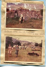
Photographs x 2- D Reids home at Mill Park 1973, 2/12/1973
David Reid (1820-1906) was a pastoralists and politician. He left school at 16 and after meeting the overlander John Gardiner he decided to look for land south of the Murray River. Equipped by his father with some 500 head of cattle, 2 bullock wagons and teams and 6 assigned servants, he reached the Ovens River on 8 September 1838. David settled at Currargarmonge, near Wangaratta. At the end of 1843 he took up land near Yackandandah. In 1847 he took up a section of the family run of which Woorajay (Wooragee) formed a part. He built the first water driven flour-mill in the district on his Yackandandah run in 1845; his woolclip of 1848 was one of the first to be handled by R. Goldsbrough and was claimed to come from sheep descended from stock imported in the 1820s from George III's flock. Going into politics, he held the Legislative Assembly seat of Murray from October 1859 to May 1862. David Reid was a highly regarded grazier and local politician who was significantly involved in settlement around the Yackandandah area. Photo demonstrates ongoing interest in the local history of the area and its early residents2 colour photographs mounted together on buff card 1. Man and 2 children (unidentified) standing outside the remains of the Reid home. 2 Dec, 1973 2. Group of unidentified people on a tour of the old homestead of D. Reid. 2 Dec, 19731. Handwritten in black ink under photo 'D. Reid's home 1845. At Mill Park. 2 Dec 1973 2. Handwritten in blue ink under photo 'Snapshots Clare Roper"clare roper -
 Kiewa Valley Historical Society
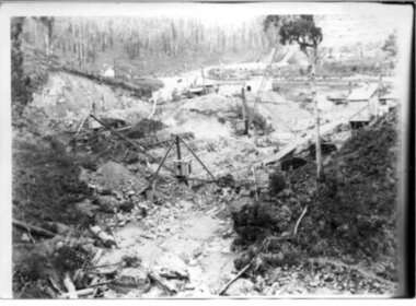
Black and white photograph, Early construction of Junction Dam Wall, c1940
In December of 1939 the excavation of a diversion tunnel was commenced to divert water from the East Kiewa River to allow construction of the dam wall. This was completed in February 1940. Lewis Construction Co. had the contract with excavation starting in February and the first batch of concrete placed in September. In 1942 the S.E.C. took over the construction and the wall was completed in March, 1944. Type of construction: reinforced concrete slab buttress.Of historical importance in the Kiewa area as it shows the form work and preparation necessary before the pouring of concrete for the first dam in the hydro electric scheme. The destruction caused by the 1939 bushfires is also evident in the upper left hand corner.A black and white photograph of the early construction of Junction Dam wall viewed from downstreamOn back of photograph (left hand upper corner) Junction Dam 4-4-81 Dam viewed from downstream 352 Time to use for correct Exp. 40 secjunction dam, bogong, secv -
 Kiewa Valley Historical Society
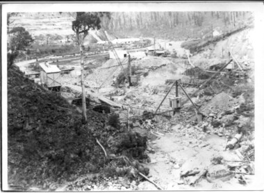
Photograph of Bogong Dam Wall Construction - 2 identical photos, c1940
Excavation of a diversion tunnel was commenced in 1939 to divert water from the East Kiewa River to allow construction of the dam wall. This was completed in February 1940 and excavation for the dam wall commenced in the same month, with the first batch of concrete placed in September. Lewis construction Company had the contract, but the S.E.C. took over construction in March 1942 and the dam was completed in March 1944. Type of construction: reinforced concrete, slab buttress.Importance in the Kiewa area as it shows the formwork and preparation necessary before the pouring of concrete for the first dam in the Kiewa Hydro Electric SchemeBlack and white photos (2 identical) of early construction of Junction Dam wall, viewed from downstream.Back of photo, upper right hand corner: No. 1 - Construction of Bogong Dam Wall (written in pencil) No. 2 - Same as one (written in pencil)construction, dam wall, excavation, bogong, secv -
 Kiewa Valley Historical Society
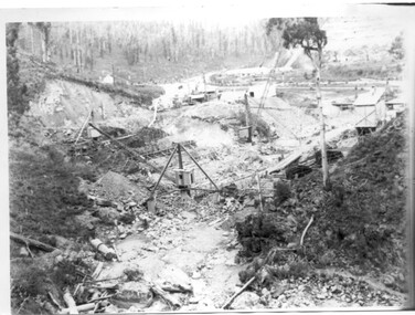
Black and white photo of Junction Dam wall under construction, c1940
In December of 1939 the excavation of a diversion tunnel was commenced to divert water from the East Kiewa River to allow construction of the dam wall. This was completed in February, 1940. Lewis Construction Company had the contract with excavation starting in February and the first batch of concrete placed in September. In 1942 the SECV took over the construction and the wall was completed in March, 1944. Type of construction: Reinforced concrete, slab buttress.Of historical importance in the Kiewa area as it shows the form work and preparation necessary before the pouring of concrete for the first dam in the hydro electric scheme. The destruction caused by the 1939 bushfires is also evident in the upper left hand cornerBlack and white photo, early construction of Junction Dam Wall, viewed from downstreamOn back of photo (left hand upper corner) Junction Dam 5-4-81 Dam viewed from downstream. 352 Time to use for correct exp. 40 sec.bogong, junction dam, secv -
 Kiewa Valley Historical Society
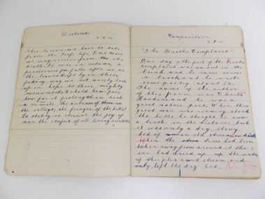
Book - Student's exercise book, Exercise Book used for dictation
The Education of English in 1913 / 1914. Hand writing in 1913 / 1914. Historical: Education through the ages. Provenance: Olivia Fisher lived in the Kiewa River at Mongans Bridge. She was a prominent member of the KVHS and donated many significant items. Black blank cardboard cover. Used as an exercise book for composition, dictation in 1913 by Miss Fisher.Olivia Fisher Mongans Bridge on inside of cover. Pages neatly written in ink but with a water stain on early pages. Very neat writing with title eg. Composition, Dictation and dated June 1913 to May 1914education. english. olivia fisher. mongans bridge. composition. dictation. handwriting. -
 Warrnambool and District Historical Society Inc.
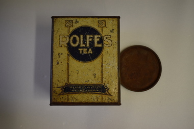
Tea Tin (Rolfe), Artefact, Early 20th century
This is a tea tin from the business of Rolfe and Co., a wholesale grocery and importing business founded in Melbourne in 1854 by George Rolfe Senior, a merchant and politician. George Rolfe died in 1871 and the business was then run by his son, George Rolfe, Junior. The business continued until at least the late 1930s. George Rolfe (1836-1919) was a keen sportsman and he began holidaying in Warrnambool for some years in the 1870s when he started buying land in the area. By the early 1880s Rolfe owned 50 acres in Warrnambool and established his holiday residence at Lyndoch near the mouth of the Hopkins River. He improved the original site with the addition of a large garden, stables, jetty, boatshed, water well, chaff and bone sheds, reservoir etc and bought other properties including Shipley on the Allansford Road and the adjoining property Fairy Hill. He continued managing the Rolfe and Co. business in Melbourne until his death in 1919. Today Rolfe’s Lyndoch property in Warrnambool is the site of an aged care facility. This tin is of considerable significance as it is a memento of George Rolfe who established the property of Lyndoch in Warrnambool and was a prominent land holder in the late 19th and early 20th centuries. (Note that we have another Rolfe tea tin but it is in very poor condition compared to this later acquisition). This is a rectangular-shaped tin with four sides originally painted yellow but now showing considerable rust. The printing on the sides is brown and white, some on a blue background and some surrounded by decorative patterns.No. 2 Rolfe & Co. Ltd 286-300 King St. Melbourne Rolfe’s Tea Rolfe and Co. was established at Melbourne in 1854. Ever since then it has enjoyed an enviable reputation as a firm which supplies to the public goods of the highest quality. george rolfe, lyndoch warrnambool, rolfe & co, importers, melbourne, history of warrnambool -
 Warrnambool and District Historical Society Inc.
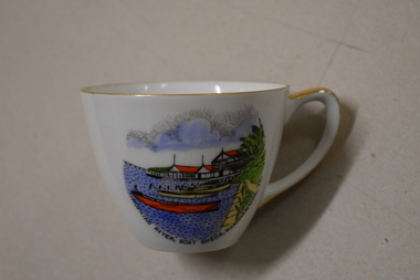
Cuo, Westminster China Australia, Hopkins River Boat, Mid 20th century
Tourism has been an important industry in Warrnambool for over 100 years. In the late 19th century Warrnambool was promoted as a spa resort offering a mild climate, seaside swimming and hot and cold seawater baths. Today tourists come in winter to see the Southern Right whales at Logans Beach and in summer they come for a beach holiday. The Hopkins River is a popular recreation destination with boating, fishing and water skiing. The Proudfoots Boathouse was established in 1885 by Thomas Proudfoot. This cup is an interesting example of a Warrnambool tourist souvenir from the mid to late 20th century.This is a small white china cup. There is gold edging around the rim and on the handle. On the side of the cup is a coloured image of Proudfoots Boatsheds at the mouth of the Hopkins River in Warrnambool. Hopkins River Boatsheds Warrnambool Fine China Westminster China Australia tourism in warrnambool, history of warrnambool -
 Warrnambool and District Historical Society Inc.
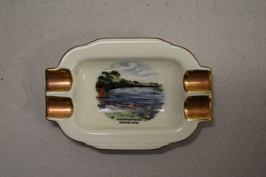
Ashtray, Alka Kunst, Warrnambool Hopkins River, c. 1960
This item was bought as a souvenir of Warrnambool in the mid 20th century when cigarette smoking was more widespread and was socially acceptable. Tourism in Warrnambool has been an important industry for over 100 years. In the late 19th century Warrnambool was promoted as a spa resort with its mild climate, sea bathing and its hot and cold sea water baths complex. Today visitors come in winter for the May Racing Carnival and to see the Southern Right whales at Logans Beach and in summer they come for a beach holiday. The image on the dish shows the Warrnambool Hopkins River near its mouth. The boatshed is no longer there with sections of the building being relocated to a site in Henna Street and used for indoor recreational purposes.This ash tray is retained as an example of a local tourist souvenir sold to tourists in the 1960s. This is a small white china dish made in an oval shape and slightly raised from the surface on which it sits. The ends of the dish have four gold coloured indents for stubbing cigarettes. There is a gold rim around the edge of the dish and a coloured image of the old boat shed and jetty on the Hopkins River in Warrnambool. On the base of the dish is the logo of the maker and printed details.Warrnambool Hopkins River Alka Kunst Bavaria tourism in warrnambool, history of warrnambool -
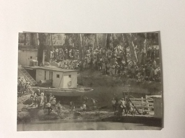 Port of Echuca
Black and white photograph, 04/03/1984
Photograph related to no.P000041, P000045 - P000048 of P. S. Adelaide re-floating. Copyright held by Riverine Herald newspaper. Original and negatives held by Riverine Herald.. Photograph taken from the river looking west towards the Echuca bank. Spectators line the higher banks and to the water line in the foreground. The back of the Adelaide and funnel is in clear view with the wheelhouse being partially obscured. The re-floating of the P. S. Adelaide was a Significant community social event evident by the number of spectators in the photograph. The community had invested a great deal of time and money into re-floating the paddlesteamer. The newspaper covered the event in detail with a number of action shots as the boat made its rear entry from the soil ramp to the water.Black and white photograph of the P. S. Adelaide on a ramp being prepared for re-floating. Spectators line the higher banks. Photograph possibly taken from the river looking west towards the Echuca bank.p. s. adelaide, echuca,victoria, re-floating of the p. s. adelaide. riverine herald newspapers, -
 Port of Echuca
Black and white photograph, 04/03/1984
Photograph related to no.P000041, P000045 - P000048 of P. S. Adelaide re-floating. Copyright held by Riverine Herald newspaper. Original and negatives held by Riverine Herald.. Photograph taken from the river looking south west as the Adelaide enters the water backwards, from the soil ramp . The right hand side of the photograph is in shadow so is very dark. 2 people can be seen on the deck with possibly another boat moored beside the Adelaide and a small motor boat to the left of that.A significant social and historical event in Echuca as many local community groups had committed many hours and much money to re-float the Adelaide to add it to the stocks for the development of the Port of Echuca as a major tourist attraction for the region.Black and white photograph of re-floating of the P. S. Adelaide in the river, possibly still partly on soil ramp. Deep shadows on the right prevent detail of front of the boat and much of the right hand bow. There are spectators in a small motorboat on left of the Adelaide and possibly another boat coming along the side of the Adelaide (2 people can be seen on the left hand side of the Adelaide). 2 people are on the deck of the Adelaide.p. s. adelaide, echuca,victoria,re-floating of the p. s. adelaide. riverine herald newspapers, -
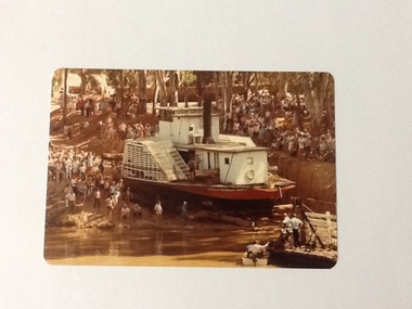 Port of Echuca
Colour Photograph, 04/03/1983
This coloured photograph shows the re-floating of the P. S. Adelaide on a soil ramp, being encouraged (rear entry) down the temporary slipway onto the river. The temporary slipway is clearly visible with a workman (possibly Kevin Hutchinson) standing at thelast log as the boat nears the waters' edge. A winching float and an outboard motor boat are at the right. Spectators line the banks of the ramp. Part of a photo sequence no.P000041; P000045; P000046; P000047; P000048 of P. S. Adelaide re-floating.The re-floating of the P. S. Adelaide was a Significant community social event evident by the number of spectators in the photograph. The community had invested a great deal of time and money into re-floating the paddlesteamer. The newspaper covered the event in detail with a number of action shots as the boat made its rear entry from the temporary slipway onto the river. Part of a photo sequence no.P000041; P000045; P000046; P000047; P000048 of P. S. Adelaide re-floating.Colour photograph of the P. S. Adelaide on a soil ramp, being encouraged (rear entry) onto the river. A winching float and an outboard motor boat are at the right front. Spectators line the banks of the ramp. Temporary slipway constructed of logs is clearly visible before the boat enters the water. -
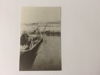 Port of Echuca
Black and white photograph, Approx. 1980
Black and white photograph of an unknown lock scene where 3 men are working from a hollow platform structure, with one person being a diver coming up or going down a ladder. Another person appears to have hold of a hose (could be oxygen) and the back view of the other person appears to be working with them watching what is happening. This could be part of lock construction as there appears to be cranes and a tripod in the distance.This black and white photograph demonstrates historical and social significance in that it gives a close up view of workmen in the process of lock construction. It appears that there is a diver suited up with helmet on, descending the ladder and a person holding what appears to be hose connected to the person diving. This scene is possibly from the beginning of the 20th century and could be about the development of the irrigation industry.Black and white photograph , portrait format, of 3 men on a hollow platform structure in a river. One man is a diver and is on a ladder which steps down into the water. Copy of an original photograph. On reverse in pencil: Price, Lock scene, location Unknown. lock scene, lock construction, price family collection, irrigation industry -
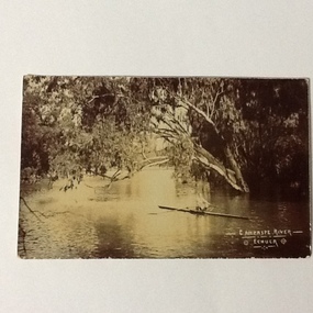 Port of Echuca
A black and white photographic postcard, Between 08/1906 - 10/1906
Photographic Postcards were very popular in the early 20th century and this shows the Campaspe river, Echuca in flood. The high water mark is exemplified by having the rower on the water. The water has inundated the surrounding bush with trees partly submerged along the right hand side of the photograph.Rowing clubs were popular in towns along the Murray river and this picturesque scene of the Campaspe river , Echuca in flood shows a man rowing a racing scull down the river.Black and white photographic postcard showing the Campaspe river, Echuca, in flood, with a man rowing a racing scull.On face : "Campaspe River, Echuca". On reverse: printed in ink :" Post Card. This space may be used for correspondence. For address only. Place penny stamp here." In pencil is written: "Aug Sep Oct 1906 Flood" "Donation H V Evans 85 Fullers Rd Chatswood NSW." " Echuca Regional Library" is stamped but has been crossed out in pen.campaspe river, echuca, echuca flood, 1906, rowing, echuca -
 Port of Echuca
Colour Photograph, 1978
P. S. PEVENSEY: Dimensions: 111ft 5 ins X 23 ft X 6ft 8 ins. Tonnage:130 tons Built: 1910 at Moama, N. S. W. References : Book: Murray river Paddle Steamers by D. Wardle Permewan , Wright & Co. : pp. 72, 129, 157 The P. S. PEVENSEY holds historical and social significance for the Port of Echuca, being the cornerstone of their paddlesteamer fleet. The PEVENSEY was renamed for the TV series All the Rivers Run, to P. S. Philadelphia , playing a staring role in the program, which has resulted in the PEVENSEY becoming a tourist attraction and has increased tourism to the Port of Echuca. The PEVENSEY was originally designed for use on the Murrumbidgee river, named after Pevensey station on that river. It was then owned by Permewan Wright & co operating out of Echuca for many years. She returned to Echuca in 1975 to begin another life as part of the Port of Echuca tourism operation.Colour photograph of the P. S. Pevensey, taken from the water, looking at the rear of the boat. There are people (all in red jackets with a logo on the back-Port of Echuca workers?), some on the bow and 2 on the stern of the boat as it steams along the river. In front of the PEVENSEY is a small row boat with a group of people in it.On the front:PEVENSEY on the back of the boat. Printed on reverse: This paper manufactured by Kodak: Print made by Kodak: KODAK: OCT.78-Mriverboats, p.s.pevensey, echuca, port of, paddle steamers, echuca wharf -
 Port of Echuca
Colour Photograph, 1978
P. S. PEVENSEY: Dimensions: 111ft 5 ins X 23 ft X 6ft 8 ins. Tonnage:130 tons Built: 1910 at Moama, N. S. W. References : Book: Murray river Paddle Steamers by D. Wardle Permewan , Wright & Co. : pp. 72, 129, 157 The P. S. PEVENSEY holds historical and social significance for the Port of Echuca, being the cornerstone of their paddlesteamer fleet. The PEVENSEY was renamed for the TV series All the Rivers Run, to P. S. Philadelphia , playing a staring role in the program, which has resulted in the PEVENSEY becoming a tourist attraction and has increased tourism to the Port of Echuca. The PEVENSEY was originally designed for use on the Murrumbidgee river, named after Pevensey station on that river. It was then owned by Permewan Wright & co operating out of Echuca for many years. She returned to Echuca in 1975 to begin another life as part of the Port of Echuca tourism operation.Colour photograph of the P. S. Pevensey, in side view, moving through the water. There are people, 2 on the bow and 3 on the stern of the boat as it steams along the river. In the background is the river bank and the bush landscape.On the front:PEVENSEY on the wheelhouse of the boat. Printed on reverse: This paper manufactured by Kodak: Print made by Kodak: KODAK: OCT.78-Mriverboats, p.s.pevensey, echuca, port of, paddle steamers -
 Port of Echuca
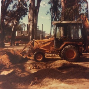
Coloured Photograph, 04/03/1984
The P.S Adelaide was launched on 21st July 1866. It was owned by J.G.Grassie from Poon Boon Station and the Officer Family of Murray Downs Station Swan Hill. The Adelaide was named after the niece of the Officer Bros, Adelaide Blackwood. The shipwright who built her was George Linklater. The Adelaide brought wool and passengers from the wool stations on the Murray and Darling Rivers down to the Echuca Wharf. In 1872 she was sold to David Blair & Sons. She was used to bring timber from the Barmah Forest to the Echuca Wharf. She did this work for the next 80 years. In 1953 she was tied up near the Mill and left. In 1958 she went to Paringa South Australia to work in the sawmill industry again. In 1960 the Echuca Apex Club and The Echuca Historical Society raised enough funds to buy the P.S. Adelaide and return her to Echuca. In November 1963 she was lifted out of the water and placed in Hopwood Gardens as this was thought to be a way of preserving her. In 1984 it was decided to return her to the water to resume work as a passenger vessel. In that time the Port of Echuca and the Echuca Wharf had been restored as a Tourist Precinct. This photograph shows the beginning of the task to return her to the river. It took several weeks in March 1984.The P.S Adelaide is extremely significant as it it the oldest known wooden hulled paddle steamers in the world. She was built in Echuca in 1866 and still operates on the Murray River today. She has worked in the Wool Industry, the Timber Industry and the Tourist Industry.This is a coloured square photograph of an orange front end loader clearing a track from Hopwood Gardens down to the river. The track was used to bring the P.S Adelaide from the gardens back into the river. The P.S Adelaide is in the background. The paddle steamer appears to be up on a trailer of some sort and is surrounded but plastic orange temporary fencing. There are small mounds of soil in the foreground.On the orange front end loader are the numbers "5900" and the word "case." p.s. adelaide, grassie, j.g, port of echuca, linklater, george, poon boon station, blair, david, murray river, darling river, logging industry, officer brothers., barmah forest, fulton & shaw, hutchinson, kevin, murray downs station, blackwood, adelaide