Showing 10952 items matching " land"
-
![Photograph - Digital image, Edward Theodore Flintoff [and grave], 1870c](/media/collectors/4f729f5697f83e03086015b8/items/54434cd12162f10ea4a15f2b/item-media/544352ec2162f10ea4a19c55/item-fit-380x285.jpg) Greensborough Historical Society
Greensborough Historical SocietyPhotograph - Digital image, Edward Theodore Flintoff [and grave], 1870c
Photograph of a portrait of Edward Theodore Flintoff and his grave. The Flintoff family came to Greensborough circa 1841. They owned, farmed and leased land north of the present Civic Drive. Edward died on 14/06/1899. A pioneer Greensborough family.Digital copy of colour photographs.flintoff family, edward theodore flintoff -
 Greensborough Historical Society
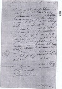
Document, Last Will and Testament of James Black, 1853_
Last will and testament of James Black of Pilgrim Inn, Plenty Road, with probate documents, 1854. Preceded the unrelated Black family who leased and owned land in the Watsonia area in the late 19th and early 20th centuries.5 p. photocopies of Will and Bondjames black [plenty road] -
 Greensborough Historical Society
Photograph - Digital image, Building of Greensborough Plaza, 1978_
Building of Greensborough Plaza was done in the late 1970's and opened in 1978. It occupied land previously used largely for residential and grazing purposes. This project saw the transformation of a sleepy outer suburb into the activity centre it now is. Digital copy of colour photograph.greensborough plaza, building projects -
 Orbost & District Historical Society
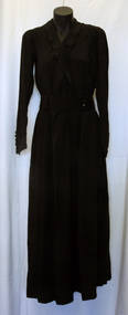
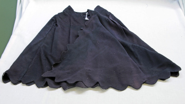
dress
This dress is from the estate of James Cameron who was one of the first Snowy River councillors for the Tambo Shire. He selected land at Lochiel in 1892. From 1902-1920 he was the Assembly member for East Gippsland.Long black silk dress with long sleeves. It is hand-made - machine stitched. There is black beading around the neck and collar. The belt is also beaded. There are small black buttons on the belt and sleeves. It has a black underskirt.costum -female cameron -
 Tatura Irrigation & Wartime Camps Museum
Photograph, Old Saleyards 1927
Original photograph of McNamara's saleyards during demolition. Looking west along Hogan Street, Tatura. New saleyards were established on land bordered by Ross Street, O'Toole Street, Maher Street and O'Reilly Roadl.Black and white photograph of old saleyards being demolished, Hogan Street, Tatura. Exterior. Approx. 1927.McNamaras old saleyards being demolished.old saleyards tatura -
 Hume City Civic Collection
Photograph, 1/12/1982
The railway land between Horne Street and the railway line was developed for commercial and industrial purposes during the late 1970s and early 1980s. The former Shire of Bulla developed much of this area and leased the space to private companies.A coloured photograph with rounded corners of 4 brick factory units. There is a large digger on the RHS. The area in front of the units has been paved but the remaining area is unsealed.factories, industrial estates, shire of bulla, george evans collection -
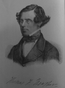 Ballarat Heritage Services
Photograph - Image, Thomas F. Meagher
Thomas Francis Meagher was an Irish nationalist and leader of the Young Irelanders in the Rebellion of 1848. After being convicted of sedition, he was first sentenced to death, but received transportation for life to Van Diemen's Land in Australia. (Wikipedia)Portrait of Thomas F. Meagher who was associated with the Young Ireland movement.young ireland, thomas f. meagher, convict, tasmania, van dieman's land -
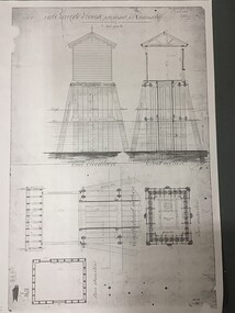 Queenscliffe Maritime Museum
Plan - Plan for a tide gauge house
An extract from the Board of Land and Works building estimates for 1858 shows an allocation of 500 Pounds for the construction of Tide Gauge Houses at various places. A copy of this plan was obtained from the Hydrographic Survey Office in Queenscliff. https://www.parliament.vic.gov.au/papers/govpub/VPARL1857-58NoB1.pdfCopy of a plan for a tide gauge house at Queenscliff 1858Clerk of works office Geelong 27 July 1858queenscliff, tide gauge house, plan -
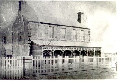 Port Fairy Historical Society Museum and Archives
Photograph
The land for this building was granted to the Benevolent Society by James Atkinson in 1850. Tenders were being called for a new "Benevolent Asylum" in 1855, the foundation stone having been laid and by 1856 the first part of the Hospital was completed. This photo taken in 1860 shows the very first building made from local bluestone. The hospital is thought to be the first such building in VictoriaBlack and white photograph of Bluestone 2 story building with verandah and paling fencehospital, institution -
 City of Kingston
Pamphlet - Colour, J. F. Brady, Matthiesson's Estate, Highett, c. 1905
Sales plan for land in the suburb of Highett, bounded by Tennyson Street, James Street and Point Nepean Road and including Maher Street, Connors Street, Enright Street, Edward Street, James Street and Matthieson Street.The developing urban area of Highett within the City of Kingston. This land sale pamphlet illustrates the subdivision of land within the municipality and the changing demographic of the district as new houses are constructed close to infrastructure.Colour pamphlet advertising for private sale subdivisions in the Matthiesson's Estate, Highett. Incorporates a map of the estate bordered by Tennyson Street, James Street and Point Nepean Road and including Maher Street, Connors Street, Enright Street, Edward Street, James Street and Matthieson Street.Handwritten in blue pencil: x marked on every subdivision on the map Handwritten in grey pencil at the end of the Price List: x not sold Handwritten in grey pencil adjacent to subdivisions 58, 167 and 166: JP. Turner Handwritten in grey pencil adjacent to subdivision 164: [indecipherable] Markings in grey pencil around the edges of the subdivision map Handwritten in grey pencil on reverse: Matthiesson / Matthiesson Estate / Matthiesson Estateland sales, estate, highett -
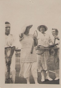 Sunbury Family History and Heritage Society Inc.
Photograph, c1920s
Four people on a tennis court beside the net and holding their rackets. They were photographed on the first courts that were in Sunbury on land behind the Post Office in Evans Street, now the site of a retail centre and bus terminal.A non-digital sepia photograph with a cream border of two ladies and two men standing on either side of a tennis net on a tennis court.tennis, evans street, tennis courts -
 Eltham District Historical Society Inc
Photograph, R.J. Manuell, Briar Hill, c.1964
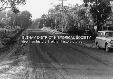
View of Squires land which was subdivided for housing - two parts Woodland Crest higher part off Woodland Grove and Calrossi Avenue, Briar Hill showing new roads with curb and channelling and footpaths. No date.Black and white photograph printed with white bordersVerso: COO2briar hill, real estate, woodland grove, squires, roads -
 Eltham District Historical Society Inc
Photograph, R.J. Manuell, Briar Hill, c.1964
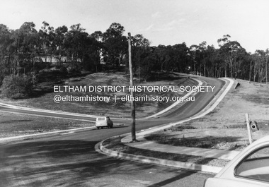
View of Squires land which was subdivided for housing - two parts Woodland Crest higher part off Woodland Grove and Calrossi Avenue, Briar Hill showing new roads with curb and channelling and footpaths. No date.Black and white photograph printed with white bordersVerso: COO2briar hill, real estate, woodland grove, squires, roads -
 Greensborough Historical Society
Article, R. A. Marsh, Church Street Greensborough, 1907_
Deals with a tenancy agreement between the Marsh and Partington families. In particular a dispute about a log crossing on the Plenty River, the access to which was across Marsh's land. There is also a brief family history of the Marsh family in Greensborough.Marsh and Partington families are Greensborough pioneer families.Collection of documents relating to the Marsh family. Some handwritten documents.marsh family, partington, greensborough, plenty river, church street greensborough, hailes street greensborough -
 City of Moorabbin Historical Society (Operating the Box Cottage Museum)
Photograph - Map of Dendy's Special Survey, 1852 Map of Henry Dendy's Special Survey of 1841, 19th Century
A Map drawn in 1852 that shows the 5,120 acres that formed Dendy's Special Survey of 1841. In 1840 Henry Dendy, a farmer in Surrey, England acquired a "Special Survey" from the Commissioners for Land and Emigration which gave Dendy the right to choose land in Port Phillip for the "bargain basement" price of only £1 per acre for 5120 acres, (an area of 8 square miles). The Special Survey also included the right to "the shipment of a worker for every £20 spent on land, whose free passage was paid by the Crown, equalling a total of 100 workers ". Accordingly Dendy sold his English holdings and paid the required £5120 and arrived in Melbourne in February 1841. However by this time land in the new colony was selling for £5 - £40 per acre. Because Henry Dendy possessed the order from the Colonial Office in London he was able to successfully oppose Governor LaTrobe's attempts to alter the price of the land. Dendy appointed Jonathan Were, (an entrepreneur, who had arrived in 1839), as his Manager and who later became a partner. Together, Dendy and Were decided on an area 5 miles south from Melbourne, bounded by North Road, East Boundary Road, South Road and to the west by Port Phillip Bay. Were and Dendy pitched their tents in the area now known as ' Park St, Brighton' and sank a well near the corner of 'St Andrew's St and Wells St'. By 1845 J.B Were and Company had bought almost half of Dendy's land and Were built himself "Moorabbin House" in Were St Brighton made from stone, quarried from local cliffs. It was still standing in 1924. Legend records Moorabbin is named after the Aboriginal word for ' Mother's Milk ' The soil is very fertile and well supplied with water especially in the area called 'East Brighton' - now known as Bentleigh and East Bentleigh - By 1850 the area had developed with numerous market gardens, dairy farms, fruit gardens and vineyards supplying food for the growing population of Melbourne.This Map shows the birth of the Brighton and Moorabbin area. On 18th January1859 Brighton was proclaimed a Municipality and a Borough by October 1863. Meanwhile, following a Petition, the area of East and South Brighton, incorporating Mordialloc, Cheltenham, Mentone, Sandringham and Oakleigh separated from Brighton to form the Moorabbin District Roads Board becoming the first Local Government Authority. Col. William Mair was elected as the first Chairman of the Moorabbin Roads Board. Moorabbin Shire 1871 developed further and was declared a City in1934. The City of Moorabbin was the largest Municipality in Melbourne before the Amalgamation of Councils in 1994 when it was divided in the south to City of Kingston and in the north to City of Glen Eira A Photo-lithographed 1852 Map showing the 5,120 acres that formed Dendy's Special Survey of 1841. Henry Dendy & Jonathan Were chose an area 5 miles south from Melbourne, bounded by North Road, East Boundary Road, South Road and to the west by Port Phillip Bay. Moorabbin County of Bourke / Photo-Lithographed at the department of Lands and Survey. /Melbourne. / Price 1/- brighton, moorabbin, bentleigh, cheltenham, dendy henry, bent thomas, were jonathan, special survey -
 Mt Dandenong & District Historical Society Inc.
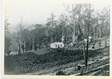
Photograph, Walker's LOT 2
Lot 2 was bought by Harry Walker in the early 1900s. Harry was married to Eva Hand, one of the six daughters of Thomas and Eliza Hand. Harry cleared the land and planted half with raspberries that remained productive until c1928. Harry's son William took over the property. The land was cut in half when the new CRB road went through in the early 1920s. John Lundy-Clarke grew up in the Kalorama/Mt Dandenong area and later in life (1972-74) began to write a comprehensive history of the area working from an original settlement map in an effort to cover all areas.Black and white photograph showing a single storey white house in the centre surrounded by crops. Handwritten description on reverse by John Lundy-Clarke.VIEW 1908 OVER LOT 2 SECTION 1 VILLAGE SETTLEMENT. TAKEN FROM RIDGE ROAD THEN MAIN ROAD FROM HALFWAY BETWEEN MOUNTJOY AND FALLS RD. CRB MAIN RD RUNS BEHIND WALKER’S HOUSE. The house seen in the vista among the tall trees beyond the raspberry patch is “Forest Edge” which was George Barber’s home when the picture was taken. The tall trees to the right of the vista were on Price’s LOT 18 and it was while cutting up one of these for firewood that a length of log weighing about ½ a ton got away downhill and leaped in one bounce over Barbers Road and Logan’s house – 1931.harry walker, william walker, eva hand, crb road, raspberries, kalorama -
 The Beechworth Burke Museum Research Collection
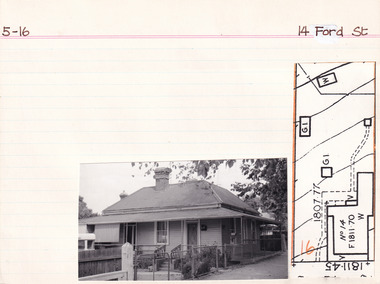
Card (Series) - Index Card, George Tibbits, 14 Ford Street, Beechworth, 1976
George Tibbits, University of Melbourne. Faculty of Architecture, Building and Town & Regional PlanningIndex system that support the research for Beechworth : historical reconstruction / [by] George Tibbits ... [et al]Arranged by street names of BeechworthEach index card includes: street name and number of property, image of property, allotment and section number, property owners and dates of ownership, description of the property according to rate records, property floor plan with dimensions.beechworth, george tibbitsbeechworth, george tibbits -
 Phillip Island Conservation Society Inc.
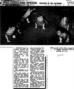
Work on paper - Photocopy of newspaper cutting, Melbourne Sun newspaper, "PHILLIP ISLAND SPECIAL PREPARED BY BILL HITCHINGS", 29.08.1969
This article by journalist Bill Hitchings describes the state of the land market and cost of transporting building materials, Phillip Island, late 1960s. At that stage a number of outlying residential estates had been created, especially on Phillip Island South Coast and at Cowes West. While blocks of land on the outlier estates were very cheap and poorly serviced, the Cowes blocks were selling at $3000 per residential block. Hitchings quotes the owner of the Hollydene motel, Reg Orr, as saying that when the new bridge opens shortly he did not expect it to create a rush of visitors or residents.Bill Hitching was a well-known Melbourne journalist. This article gives an idea of land values on Phillip Island in the late 1960s, the fact that business owners were prepared to upgrade and expand their businesses to cater for extra potential demand on accommodation, and the strong identification of Phillip Island with the Phillip Island Penguin Parade in the minds of the general public in Melbourne. The significance of the new Phillip Island bridge to Phillip Islanders and visitors, and the cost of the bridge, are also outlined. Reg Orr was highly active in the business community of that era on Phillip Island. The Hollydene motel was a well-known Phillip Island accommodation venue.T-shaped article cutting with large image at top of article, dark due to poor photcopy. Double collumn text under photo clearly readable. Black and white.Sun/29/8/6 (?) Probably: Melbourne Sun newspaper, 29 August, 1969phillip island, phillip island tourism, development, hollydene motel, reg orr, phillip island penguin parade, land values, phillip island first bridge, phillip island 2nd bridge, transportation costs -
 Sunbury Family History and Heritage Society Inc.
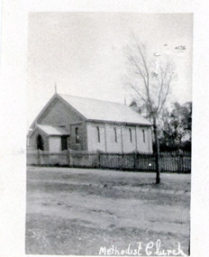
Photograph, Former Sunbury Methodist Church
The church in the photograph is the former Methodist Church which is on the NW corner of Barkly and Harker Streets inn Sunbury. It was built on land donated by Thomas Woods at Lot 14 Barkly Street where in 1870 a small weatherboard building was built. In 1879 John Browning gifted land at 13 Barkly Street for the building of a new brick church on that site. The brick church continued to be a place of worship until the June 1977 when the Presbyterian, Methodist and Congregational churches came together and worshipped as the Uniting Church. St. Andrews Uniting Church have been the owners of this building since that time. A non-digital black and white photograph of a little Church building with the words Methodist Church written across the bottom of the image.methodist church, methodism, barkly street, harker street, uniting church -
 Darebin Art Collection
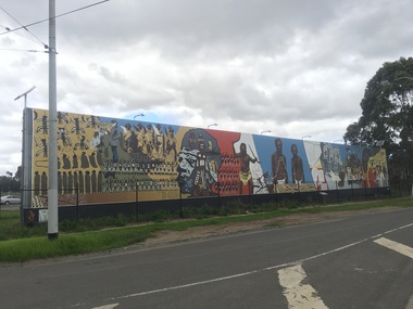
Artwork, other, Megan Evans, Millie Yarran, Ian Johnson, Les Griggs, Elaine Trott and Ray Thomas, Koori Mural, 1983
The Koori Mural was designed by artist Megan Evans in consultation with a committee from the Aborigines Advancement League consisting of the late Lin Onus, the late Molly Dyer, the late Ron Johnson and the late Elizabeth Hoffman. It was painted by Evans and renowned Aboriginal artist Ray Thomas along with Ian Johnson, Millie Yarram, Les Griggs, Elaine Trott and a number of volunteers. The mural has considerable historical and cultural significance and refers to the experiences of the the Aboriginal and Torres Strait Islander communities, from early colonial history to the more recent struggle for social justice. In 2014 the mural was replicated onto a vinyl banner and installed at its current site. The Northcote Koori Mural was originally located on Council land in High Street, Northcote, opposite the Northcote Town Hall. A huge, free-standing wall was built specifically to accommodate the mural which was painted on site. The land on which the mural was housed was later sold, however, and the mural was relocated to the Aborigines Advancement League in St. Georges Road, Thornbury. Conservation work in 2014 and original panels decommissioned and vinyl banner hung in its place (with Total Outdoor Media). In 2015 solar lights were installed along with landscaping to the front of the mural and a plaque depicting the history on the mural. -
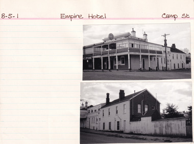 The Beechworth Burke Museum Research Collection
Card (Series) - Index Card, George Tibbits, Camp Street, Beechworth, 1976
George Tibbits, University of Melbourne. Faculty of Architecture, Building and Town & Regional PlanningIndex system that support the research for Beechworth : historical reconstruction / [by] George Tibbits ... [et al]Arranged by street names of BeechworthEach index card includes: street name and number of property, image of property, allotment and section number, property owners and dates of ownership, description of the property according to rate records, property floor plan with dimensions.beechworth, george tibbitsbeechworth, george tibbits -
 Greensborough Historical Society
Book, Typical Homes that would be constructed by Mitchell Trading Pty Ltd, 1960_
An early advertising brochure for prospective homeowners to choose the style of home they would like built. House and land packages were available in the areas of Bundoora surrounding the Loyola and Parade College sites, which were monasteries in the 1960s. The aerial photographs show the open nature of the landscape from Bundoora across to Greensborough and Watsonia in the 1960s. Book of black and white photographs bound in brown card cover. Contains 14 photos of houses and shops and 14 aerial photos of Bundoora including the Loyola and Parade College areas. Includes notes from Gary Partington.In pencil inside front cover: 29/1/1960.houses, bundoora, greensborough, watsonia, loyola college, parade college, mitchell trading, aerial photography -
 Greensborough Historical Society
Memoir, Life at Alwyn - 1950s and 60s by Faye Fort, 1947-1969
Faye recounts stories about growing up in the Partington home "Alwyn" in the mid 20th century. At this time agriculture played an important role in the Greensborough district and the land around Alwyn was used for poultry, vegetables and cut flowers.A primary source recollection of Greensborough in the mid-20th century.2 typed pages. partington family, greensborough, alwyn, alan partington, farming -
 Greensborough Historical Society
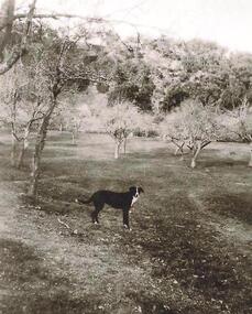
Photograph - Digital image, Old orchard at Partington Flat, 1930c
Remnants of the Partington orchard at Greensborough on land that is now the Partingtons Flat reserve in Greensborough. Charles Partington and family came to Melbourne in the 1840s and moved to Greensborough where they farmed along the Plenty River. This dog belonged to Jessie Partington.Digital copy of black and white photograph.partingtons flat, partington family -
 Kiewa Valley Historical Society
Maps - Kiewa Valley Parish Maps x3 and Kiewa Area Planimetric Map x1
Planimetric maps are 2 dimensional representations of the Earth's surface, showing the location and spatial arrangement of features such as roads, buildings, and bodies of water. The parish maps show the occupiers with leases or licences of the land. These are updated by the Department of Lands regularly. The names of early settlers of the Kiewa Valley occupying land by lease or licence are shown. Many of these familie's descendants still live in the Kiewa Valley.1. Kiewa Area Planimetric Map (photo) 2. Wermatong, County of Bogong Parish Map 3. Mulllindolingong, County of Bogong Parish Map 4. Mullagong, County of Bogong Parish Map All black and white kiewa valley. parish maps. land owners -
 Orbost & District Historical Society
cape, Before 1922
This cape comes from the estate of James Cameron who was one of the first Snowy River councillors for the Tambo Shire. He selected land at Lochiel in 1892. From 1902-1920 he was the Assembly member for East Gippsland.A black shoulder cape made of crepe silk. It has scalloped edges and is probably hand-made. It fastens with press studs and the hems have been machined.cape silk clothing -
 Eltham District Historical Society Inc
Photograph, 32 Piper Crescent, Eltham, 16 May 1990, 16/05/1990
Peter Conlan (via MysteryMonday website post) FEBRUARY 13, 2018 AT 12:13 PM: Photo is 32 Piper Crescent and the land to the right (behind the fenceline) is now the back of the properties at 1 to 4 Artists Hill.Roll of 35mm colour negative film, 2 stripsKodak GB 200 5096artists hill, eltham, houses, streets -
 Eltham District Historical Society Inc
Photograph, 32 Piper Crescent, Eltham, 16 May 1990, 16/05/1990
Peter Conlan (via MysteryMonday website post) FEBRUARY 13, 2018 AT 12:13 PM: Photo is 32 Piper Crescent and the land to the right (behind the fenceline) is now the back of the properties at 1 to 4 Artists Hill.Roll of 35mm colour negative film, 2 strips (composite of three frames)Kodak GB 200 5096artists hill, eltham, houses, streets