Showing 13826 items
matching tasmanian-built
-
 Wodonga & District Historical Society Inc
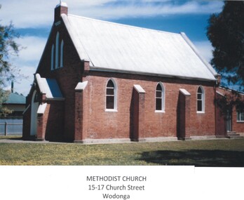
Photograph - First Methodist Church, Wodonga
Land for the Methodist Church in Wodonga was reserved in 1864. By 1865 the Reverend Francis Neale, a Wesleyan minister was appointed to Albury from where he supervised the congregation at Wodonga Creek until a church was built in 1873. By 1885 Wodonga and the other preaching places on the Victorian side of the Murray had become a separate circuit under the Reverend L. J Rowlands. This circuit included Bethanga. Kiewa. Leneva, Kergunyah and Bonegilla. In the 1960s the Methodist congregation built a new chapel in Hovell Street, Wodonga. The creation of the Uniting Church during the 1970s meant that the services were held in the former Presbyterian Church and joint Sunday School classes were conducted in the Methodist Hall. In 1961 the Church building and land was purchased by the Ukrainian Community for £2,000. Ukrainian Catholic families in Wodonga donated £100 each towards the purchase. Additional fund raising such as carol singing in nearby towns (Benalla, Wangaratta, Albury and Wodonga) assisted with the purchase of the Church. The former Methodist Church was in poor condition and the members of its new congregation undertook the replacement of the floor, the footings, replastering of the walls and the construction of an altar. The renovations cost a further £400. Once a month a priest came up from Melbourne to conduct services in the Church. On completion it was blessed by Bishop Ivan Prasko to become St Olga's Catholic Church (Ukrainian). In 1965 the Church was dedicated to its patron St Volodymir, with Bishop Varlamm (Sydney) and Bishop Donat (Melbourne) taking part in the ceremony. The members of the Ukrainian Catholic community also built a hall and smaller chapel in Hunt Street, Wodonga. With a declining congregation, this property became more manageable to maintain than the original brick building and the decision was made to close the building in 2010. In 2022 the building and extensive block of land in Church Street was sold commercially for potential redevelopment.These images are significant because they depict an early Wodonga Church building.A collection of coloured photographs depicting the first Methodist Church in Wodonga, Victoria It was a red brick church with a steeply pitched gable roof and parapeted gable walls. There was a small front porch with matching roof and gable treatment to the front. Simple timber Gothic windows were along the sides, with a tri-partite window above the porch. Two sections of this window featured stained glass, the other was opaque glass. Red brick buttresses were topped with white-painted render, as were the parapets, and the windows were also outlined with white painted render. Timber joinery was painted white. A front path led directly to the porch and the Church was flanked by mature oak trees. A small, relatively modern red brick skillion extension was added to the rear of the building.wodonga churches, methodist church wodonga, ukrainian catholic church wodonga -
 Eltham District Historical Society Inc
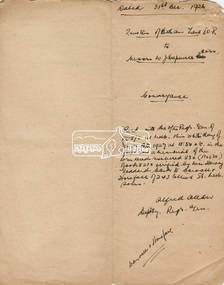
Document, Conveyance, Lot 20 Henry Street, Eltham, Hope of Eltham Tent No. 195 I.O.R. to W.J. Capewell and others, 31 Dec 1926
Indenture between Jack Alfred Harrison, Accountant, Edward Samuel McColl, Council Employee, both of Eltham and William Wilson, Coachbuilder of Research, the Trustees of a certain Friendly Society known as The Hope of Eltham Tent No. 195 Victorian District I.O.R of the one part and William James Capewell, Butcher, Ernest James Andrew, News Agent and George Birchall, Hatter all of Eltham of the other part, Trustees for The Eltham Hall, for the purchase of Lot 20 Henry Street for £750. Witnessed by Hubert James Carter J.P for Jack Alfred Harrison, A.H.C. Price J.P. for Edward Samuel McColl and J. Webster J.P. for William Wilson. Originally purchased in 1856 from Thomas Roberts, Yeoman of Little Eltham, for £10 for use by the Wesleyan Chapel, represented by indentured Trustees, Rev. Barnabas Shaw Walker, Minister of the Pentridge Circuit, Francis Thomas, Farmer of Keelbundora, William Harriman, Blacksmith of Nillumbik, Nicholas Rodda, Farmer of Nillumbik, Aaron Grimshaw, Farmer of Greensborough, Joseph Cooper, Gardener of Keelbundora, Peter Dredge, Scholmaster of Jika Jika and Samuel Jeffrey, Farmer of Jika Jika. Lot 20 of Subdivision of Portion 13, Section 4 of the Parish of Nillumbik in the County of Evelyn was located on the southern side of Henry street in Little Eltham North, where the current Our Lady Help of Christians Catholic Church is situated. It became the location of the Eltham Rechabite Hall. In 1893 a new hall was built and further enlarged in 1919. At the commencement of 1922, the property was purchased from the Independent Order of Rechabites with publicly subscribed funds and a new hall built at a cost of £750 and improved road access constructed to reduce the grade, running from Dudley Street to Henry Street. This hall was eventually replaced with the new Shire Offices and Hall built on the corner of Arthur Street and Main Road, which was opened in 1941. Traces the earliest history of the Eltham Public Hall in Henry Street and the various names, occupations and abodes of the Trustees associated with the property -
 Southern Sherbrooke Historical Society Inc.
Photograph - Kirkland family photos
Ethelbert Cyril Kirkland was born in inner Melbourne on 1st November 1900, to Ethelbert George and Mary Ann (nee Cooke). His father died in 1912. On 4th June 1917, while living with his mother in South Yarra and working as a factory hand, Cyril enlisted in the Army. His height was 5' 8" and he gave his age as 18. He was officially enrolled on the 18th June and by October he was in England, specifically in hospital with mumps. After coming clean about his actual age in March 1918, he was discharged on 13th June 1918 and shipped back to Australia, having forfeited all his pay from March onward. On 9th December 1919 he enlisted again, stating he was a single man. He was by then working as a carpenter and had grown 3 inches. He was discharged on 2nd June the following year. He married Mary Ann Reynolds (b. 4th February 1906) on 7th March 1929. For a few years Mary and Cyril moved around, from Moonee Ponds to Iona and then Kelletts Road, Lysterfield. Cyril worked as a farmer and labourer. By 1941 they were running a dairy farm on Engelke Rd. Then they purchased the triangular block of land on (now) Belgrave-Hallam Rd from Mr & Mrs Clarke, where they built a dairy and ran that and a milk delivery service until selling it to Mr Dave Pollock in the 1950s. In 1952 they built the Belgrave South Garage on part of their land at the corner of Belgrave-Hallam Rd and Deviation Rd. Their son Robert (Bobby) ran the garage . Their daughter Mary married Jack Rae from Narre Warren North. Jack played football for Sth Belgrave. Mary died on 27th May 1957 and Cyril died on 6th April 1980. Our society has a long oral history which was recorded with Bobby Kirkland several years ago. -
 Ringwood and District Historical Society
Photograph, Ringwood Methodist Church on site at Cnr. Melbourne St. and Whitehorse Rd 1904
Written on backing sheet, "Methodist Church on site at Cnr. Melbourne St. and Whitehorse Rd. On its removal to Greenwood Ave. Mr. J.B. McAlpin built shops on this site - land (Dimmey's) including his own estate agency." One photograph claimed church was moved to Greenwood Ave in 1916. Photograph taken in 1904. Another photograph states that the photograph is of the Methodist Church and Sunday School. Inserted in the sleeve of one of the photographs are two small postcard photographs that state they are, "Methodist Church in Main Street, Ringwood opposite railway station. See Mechanics Institute where Town Hall now stands - c1910. Photo by L. F. East". -
 Daylesford & District Historical Society
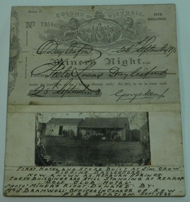
Miner's Right & Photograph, Miner's Right Pietro Lucini, Daylesford and Photograph of first hotel & stores at Jim Crow now Hepburn
Pietro Lucini owned the building on the right in the attached photograph. He operated a general store here prior to building a new building opposite this site. He was involved in gold mining activities in the early settlement of Spring Creek, now known as Hepburn Springs. Dr Francesco operated a store in building on left. A document and photograph glued on cardboard. 01451.1 Miner's Right, No. 7351. Glued on cardboard. 01451.2 A separate photograph of two early stores at early Jim Crow diggings, now Hepburn Springs. Text at bottom of photograph, " First hotel and store built at Jim Crow Diggins Daylesford. Now known as Hepburn Springs. These buildings are still standing at rear of "Golf Club Hotel. Photo Miner's Right donated by Mr J Bramwell Officer in charge of Kew Fire Station. Sept 1936". Back of cardboard has the following writing; "Donated by Mr J Bramwell Officer in Charge of Fire Station, Walton St. Kew. Sept 1936", "Donated by Beryl Jean Frame (per Mrs.R.Bland Ferntree Gully) 1987", "Box 4", WINGRAM 47 Victoria Road Auburn Melb 1- JAN 1940, Daylesford & District Historical Society.gold mining, lucini, buildings, hotel, spring creek, golf club hotel -
 Bacchus Marsh & District Historical Society
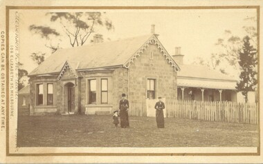
Photograph, Stone Villa house 4 Bennett Street Bacchus Marsh 1883
The house depicted in this image was constructed in 1865 for James Young a prominent local businessman and participant in community affairs. James Young left Bacchus Marsh in 1869. In 1870 Stone Villa was purchased by local solicitor Francis Gell. In 1872 it was bought by William Collyer. For a time before 1883 it was used as a school operated by Mr Thomas Kissock and his wife. From 1883 until 1922 it was used as a parsonage by the Church of England. In 1922 it was sold to Frederick Slack as a private residence. Since Slack's ownership there have been other owners. As of April 2024 it remains as a private residence and is listed as a heritage property in the Moorabool Shire planning scheme. The identity of the two women and young girl in the foreground of the image has not been established. One of the women, and the child are possibly the wife and daughter of the Rev A.C. McCausland who was the Church of England Vicar in Bacchus Marsh from 1872 until 1885 and would have resided in this house in 1883 when this picture was produced.An early visual record of one of the most culturally and architecturally significant nineteenth century stone houses in Bacchus Marsh.Small sepia 'carte de visite' style unframed photograph on card with gold border framing photograph. Housed in the album, 'Photographs of Bacchus Marsh and District in 1883 by Stevenson and McNicoll', the Jeremeas Family Album. The photo is of a stone dwelling with an ornate gable above the inset front door which is flanked by two double windows, one of which is a bay window. The gable roof line bears ornate woodwork. A weatherboard extension with verandah has been added to the rear of the house, running north-south. A picket fence lines the block to the side of the dwelling. Two elegantly dressed women, both holding a furled umbrella, stand at the front, one holding the hand of a little girl.Printed On the front: Stevenson & McNicoll. Photo. 108 Elizabeth St. Melbourne. COPIES CAN BE OBTAINED AT ANY TIME. On the back: LIGHT & TRUTH inscribed on a banner surmounted by a representation of the rising sun. Copies of this Portrait can be had at any time by sending the Name and Post Office Money Order or Stamps for the amount of order to STEVENSON & McNICOLL LATE BENSON & STEVENSON, Photographers. 108 Elizabeth Street, MELBOURNE. Hand written on the reverse: 'Stone Villa built by James Young 1860 (sic) as his private residence, later as a school (Mr and Mrs Kissock proprietors) bought by CofE for Vicarage 1883-1922. Courtesy of Mrs J Jeremeas, Photo 1883' james young 1816-1871, houses, stone villa bacchus marsh, clergy residences, bacchus marsh vic. history, schools bacchus marsh, stevenson and mcnicoll 1883 photographs of bacchus marsh and district -
 Bendigo Historical Society Inc.
Photograph - Photographs of Lewis Lewis and others
Photographs of Lewis Lewis and Reg Ansett in various locations with family and friends. Three photocopies of photographs and 1 real photograph. They all have Lewis Lewis in them as well as others. The real photograph is a black and white photo of Lewis Lewis and his family beside a fence looking over the sea with large sea cliffs behind them (Image 3a). One of the photographs is a copy of this photo (Image 3b). Another photocopy is black and white photo of a different group of people in the same location by the sea (Image 3c). The last photocopy is black and white of a small plane with a group of people beside it (Image 3d). The real photograph has an attachment on the back that says, '1930 - 1940 on tour with Bus owner Booter and Bendigo (Image 3a). His Mother, his grandfather, his wife, Reg Ansett, his Aunty and Lewis Lewis.' The photocopy of the real photograph has black pen written on it that says, 'His mother, his grandfather, wife, Reg Ansett, his Aunty, Lewis Lewis, Garage Boort and Bendigo Bus owner 1920 - 1940. Built Medical Centre he left behind Rosanna,' (Image 3b). The last photocopy has blue pen written above the photo saying, 'History Lewis Lewis and Reg Ansett,' (Image 3d). lewis lewis, seaside, reg ansett, plane, buses -
 Camperdown & District Historical Society
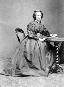
Photograph - Isabella Taylor (nee Dawson), c1890
Isabella Park Taylor, nee Dawson (1842-1929), friend of Western Victorian First Nations people, and student of their languages and customs. Isabella grew up at "Kangatong" (1844-1866) in the company of First Nations people and became fluent in their languages. With her father, James Dawson, she wrote the book "Australian Aborigines" (1881). She married William Andrew Taylor in 1877 and they built a fine homestead on their property at "Renny Hill'' near Camperdown, Victoria. Together they had two children, Effie, born 1878 and Katherine in 1880.Studio portrait of Isabella Taylor (nee Dawson) sitting at an occasional table.cdhs, cdhsfirstnations, djargurd wurrung, djargurdwurrung -
 Camperdown & District Historical Society
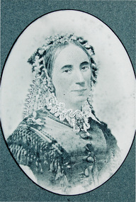
Photograph - Isabella Dawson as a young woman, c1870
Isabella Park Taylor, nee Dawson (1842-1929), friend of Western Victorian First Nations people, and student of their languages and customs. Isabella grew up at "Kangatong" (1844-1866) in the company of First Nations people and became fluent in their languages. With her father, James Dawson, she wrote the book "Australian Aborigines" (1881). She married William Andrew Taylor in 1877 and they built a fine homestead on their property at "Renny Hill'' near Camperdown, Victoria. Together they had two children, Effie, born 1878 and Katherine in 1880.Studio portrait of Isabella Dawson as a young womancdhs, cdhsfirstnations, djargurd wurrung, djargurdwurrung -
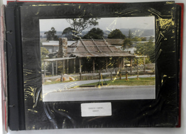 Orbost & District Historical Society
albums, late 1980's
These two albums were used at the Slab Hut - Orbost Visitor Information Centre. The Orbost Visitor Information Centre is situated in Forest Park on Nicholson Street. The centre is housed in the historic Slab Hut. The hut was an original family dwelling built in 1872, on a site approximately three kilometres upstream from the junction of the Buchan and Snowy Rivers. No nails were used in the construction; it was all wired together. After a period in storage the slab hut was opened in its present location in Orbost as the Information Centre in 1987.These albums are contemporary records of the construction and relocation of an iconic Orbost building, the Slab Hut.Two large photo albums. 2280.1 has no front cover. The back cover and spine are red. The pages are black and most photos are labelled. They are photographs of the Orbost area. 2280.2 has brown covers. It contains photographs of the construction of the gardens and buildings around the Slab Hut (Orbost Visitor Information Centre). On the cover in gold print is "PHOTOS".slab-hut-orbost album-photographs-orbost -
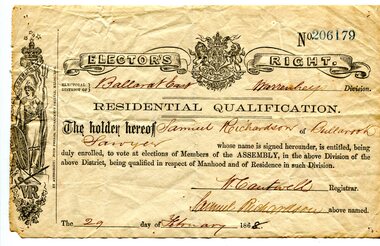 Orbost & District Historical Society
certificate, 29th February 1868
This Elector's Right Certificate, No. 206179, is for Samuel Richardson, a sawyer, who lived at Bullarook in the Ballarat East Division. It has been signed by W. Cantwell, the registrar and by Samuel Richardson. As a resident and a male he was entitled to vote in the Ballarat East Division at Victorian State elections. Samuel Richardson was a sawmiller and farmer in Orbost. He built The Curlip, a wooden paddle-steamer of 9 tons gross and dimensions of 43 feet long, 10 feet wide and a depth of 3 feet, on the slipway at their Tabarra sawmill in 1890. This item is associated with the Richardson family, early Orbost pioneers,A white paper certificate with black print and hand-written details. at the top is the British coat-of-arms. It is an elector's right certificate made out to Samuel richardson.suffrage richardson-samuel elector's-right-certificate -
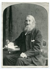 Orbost & District Historical Society
black and white photograph, second half 19th century
The Richardson family was one of the very early settler families to establish themselves in the Orbost district. Samuel Richardson was a sawmiller and farmer in Orbost. He built The Curlip, a wooden paddle-steamer of 9 tons gross and dimensions of 43 feet long, 10 feet wide and a depth of 3 feet, on the slipway at their Tabarra sawmill in 1890. The Ballarat Horticultural Society was established in 1859 by a group of thirteen men with the aim of establishing an association for all lovers of horticulture. There were many such societies throughout the colonies making a contribution to their communities.Samuel Richardson, with his family, was a very early settler in the Orbost / Marlo district. A black / white portrait photograph of a full-bearded man sitting at a table with one hand leaning on his knee and the other holding a piece of paper. He is wearing a dark suit with a longis coat.on back - Samuel Richardson 1821-1892richardson-samuel curlip timber-orbost -
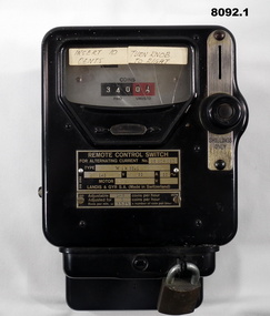 Bendigo Military Museum
Functional object - HEATER METERS, ONE SHILLING, Landis & GYRS.A, Pre 1970
.1) This one was used in the Writing room which later became a Meeting room then finally the RSL Building & History room. it was attached to the LH side of the Fire Place and ran an old Electric Heater on the Hearth. It was used up to about 2005. .2) This one was in the Old Kitchen built on the side of the Soldiers Memorial Institute in the mid 1960's This one ran the Electric stoves used by the Womens Auxiliary of the Bendigo RSL and to make the Rum & Coffee for the ANZAC Day Dawn service. The kitchen was removed as part of the Renovations in 2016 - 18..1) Heater meter, metal construction black coating, top face has a glass section with a "usage meter" saying "coins paid, unused", metal plate under with details re numbers, maker, coins per hour, on right side slot for "Shillings only" with knob, removeable lockable tray at bottom for coin storage and removing. .2)Same style as .1) but a different glass face style metering, it has 11 circular dials with one hand, these show "Coins paid, coins unused", this one shows the round meter going around when in use. The only differance between to two shapes is at the top re fixing to a wall..1) On plate, "Remote Control Switch - for alternating switch No 26 204 020 - Type Wik 36.1 - Adjustable 1-6 coins per hour, Adjusted for 1 coin per hour" On stickers, "insert 10 cents - Turn knob to right". .2) On glass section, "230/240 revs per KWH - 1200 - Serial No 8338380 - 5 - 50". On label stuck on, "10 c equals 1/2 hour"brsl, smirsl, shilling -
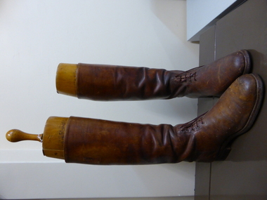 Warrnambool and District Historical Society Inc.
Boot, Charles Rogers
These boots belonged to Captain Charlie Rogers of the Australian Army who wore these and ceremonial regalia when he was part of the Guard of Honour during the visit of the Duke of Gloucester in 1934. The visit was part of Victoria’s centenary celebrations and the Duke officially opened the Melbourne Shrine of Remembrance. Rogers was a well-known Warrnambool identity in the 1930s, 40s and 50s as a horseman and an Army identity. He built a house in Birdwood Avenue, Warrnambool, in 1935 and was a long-serving Warrnambool Show official as a judge of equine events. Rogers died in 1961. These items are of great interest as examples of the boots worn by Army Lighthorse personnel in the 1930s. The mechanism for keeping the boots in good condition is of some technological interest. They are also of interest because they belonged to a well-known 20th century Warrnambool person. These are two knee-high brown leather boots with brown laces. The boots are slightly scuffed. Inside the boots are two pieces of red-striped canvas. The boots have wooden inserts to support the boots in storage. These wooden inserts, all varnished, are in four pieces - a solid foot shape to fit in the foot of the boots, two pieces shaped to fit the calf of the leg padded with green felt, one with slight indents at the top and the bottom and the other with a decided groove and the centre piece that has a hole cut out to fit the shape of the other two. This last piece has a wooden handle with a metal attachment. There is only one handle as it can be screwed out and fitted to either wooden insert. On the two wooden inserts ‘R ‘ for right and ‘L’ for left, marked twice on each insert.charles rogers, duke of gloucester, warrnambool -
 Warrnambool and District Historical Society Inc.
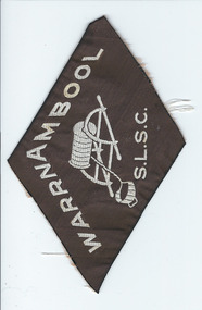
Badge, W'bool SLSC, Mid 20th century
This badge would perhaps be attached to the uniform or blazer of a member of the Warrnambool Surf Life Saving Club. This club was established in 1930 with Fletcher Jones (President) and Bon Nutt being notable early members. A ladies’ club was also formed in 1930. As Warrnambool has a bathing and surf beach and is situated on a coastline with many popular surf beaches the Warrnambool Surf Life Saving Club is an important group with a proud history of service to the community. The current clubhouse, built by members and other volunteers in the 1950s, includes a public restaurant today. This badge is interesting as a memento of the Warrnambool Surf Life Saving Club, an important club in Warrnambool’s community. This is a diamond-shaped cloth badge. It is made of brown cloth with white cotton stitching and an image of a rescue reel and rope. ‘Warrnambool, S.L.S.C.’warrnambool surf life saving club, warrnambool -
 Warrnambool and District Historical Society Inc.
Magazine - Project, Warrnambool: sandstone era of the eighties, 1973
Geographically situated on the coast Warrnambool has large tracts of sedimentary rock, some of which is sandstone. It therefore was a readily available material and as a relatively soft stone it was easily quarried and cut. By the 1880’s Warrnambool had been established for around forty years and was proving to be a settlement of some wealth. Hence the trend to build bigger and grander homes. There are numerous other commercial buildings which are built in sandstone and many of the original quarries are still visible around the Warrnambool area. Most of the properties are situated in the central part of Warrnambool. This collection of photographs is a good cross-section of some of the significant homes and buildings of Warrnambool. It also shows how they look 100 years after being built.A collection of 18 black and white photographs of sandstone houses, mounted on card and tied loosely with string. The addresses of each house are hand-written in black pen beside each photo. Title is written in black pen on cover page.Graeme Blake 1973 in bottom RH corner, Via * Fraser & Chris How in blue pencil.warrnambool, sandstone, sandstone houses, 1880 warrnambool -
 Warrnambool and District Historical Society Inc.
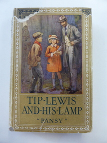
Book, Tip Lewis & his lamp, 1925
This book was awarded by the Grasmere Presbyterian Sabbath School to Stuart Jenkins for his essay on the Apostle Paul. The teacher was H. Giles. The Giles family lived on the Allansford Road in the early 20th century. There were several Jenkins families in the Warrnambool district and some were early settlers in the Wangoom/Grasmere area. Some Jenkins families were associated with hotels in Purnim and Woodford and the properties Grasmere Station, Roseneath, Dyffen, Vrowen and Fala Park. St. Andrew’s Presbyterian Church at Grasmere was built in 1898 (the second church on the site). This is a hard cover book of 252 pages. The cover is brown with a multi-coloured illustration of a man and two children on the front cover and black lettering and border ornamentation on the spine and front cover. The dust jacket has a yellow background and the same illustration as on the front cover. The dust cover is partly torn away. There is a full page colour plate at the beginning of the text and a page of advertisements for books by the same publisher at the end of the text. The inscription is handwritten in black ink. ‘Grasmere Presbyterian Sabbath School ‘Essay’ Missionary Journeys of the Apostle Paul. First Prize Awarded to Stuart Jenkins from his teacher, H. Giles’. stuart jenkins, grasmere, history of warrnambool, grasmere presbyterian church -
 Kiewa Valley Historical Society
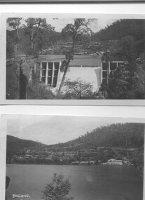
Two black and white photos, Photo downstream view of Junction Dam Wall and photo of Bogong Village and Lake Guy, c1950
Photo No. 1 - Junction Dam wall was commenced in February, 1940 and completed in March 1944. Type - reinforced concrete slab and buttress. Height 25.9m, and crest length 121.9m. Lewis Construction company had the original contract, but was replaced by the State Electricity Commission in 1942. Photo No. 2 - Bogong Village was the first village built to house workers and their families working on the Hydro electric scheme. Construction commenced 1940. The single men's quarters are slightly right of centre on the foreshore. Lake Guy was named after a former resident engineer.Shows the type of terrain where the village is located resulting in the tiered layout that was necessary in order to erect housing.set of 2 black and white photos - Photo No. 1 - downstream view of Junction Dam Wall Photo No. 2 - Lake Guy and Bogong Village. Both are on photographic paperPhoto No. 1 - Upper right hand corner, back of photo, handwritten in ink or biro, Bogong 1950 Photo No. 2 - Left lower corner, front of photo in white, Bogong.bogong village, lake guy, secv -
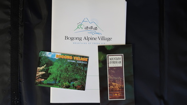 Kiewa Valley Historical Society
Papers - Bogong Village & the 'Commissioner's' Lodge & Progress Association Members, c 1997/1998
Bogong Village was built by the SECV in 1940 for the workers of the Kiewa Hydro Electric Scheme. In 1971, 30 houses were furnished for use as holiday homes for SEC personnel throughout the State. From 1989 to 1993 the houses were restored & renovated.During the 1990s the buildings in the village had been leased to private owners. Many of them rented their houses for tourists. The Commissioner's lodge was on the other side of the Mt Beauty - Falls Creek road, above Bogong Village. Wally Baldwin ran it in the 1960's.It was destroyed by the 2003 bushfires.These papers present a history of 'the Commissioner's lodge' and Bogong Village in the 1990's. The Progress Association was an active community group in 1963/64.Papers advertising Bogong Village & the Lodge for accommodation with rates 1997/1998. Describes the alternatives, maps and cafe hours, Also, 'Jan's Recollections' and on the back of these pages a hand written list of members of the the Progress Association 1963-64 as 'per Mr A. McCullough's spiel'. In original folder and includes a pamphlet & postcard.bogong village, secv lodge, lake guy, state electricity commission of victoria., kiewa hydro electric scheme, tourism, accommodation -
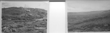 Kiewa Valley Historical Society
9 small black and white Photographs, c1950
These photos were taken in 1950 by Bill Peel who was appointed as a secondary teacher at the newly built Mt. Beauty School in January 1950. He was the entire secondary staff for an enrolment of 4 students in Form 3 (year 9), 9 in Form 2 and 25 in Form 1. There were also 4 primary teachers as the school combined both primary and secondary education. He was provided with accommodation at the staff hostel (Mt. Beauty Chalet). A autobiography is also enclosed describing his 12 months as a teacher in Mt. Beauty.These photographs give a clear picture of the stage of construction of housing in both Bogong Village and Mt. Beauty in 1950. Large workmen's camps are clearly visible at both sites. Construction at Rocky Valley Dam site has just begun. They are of historical significance. The autobiography gives an excellent insight into conditions teachers faced in small country schools;Nine small black and white photographs3 photos stamped with "1 856", 4 photos stamped with "210, 2 photos are identified with hand written inscriptions, in ink, on the back - "Railway Bridge Bright '50" and second photo "Lake Catani '50" also 'Kodak' circular stamp on back of both.mt. beauty, bogong, acccommodation, education, rocky valley -
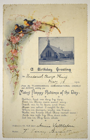 Warrnambool and District Historical Society Inc.
Card - Birthday Card, Warrnambool Congregational Church, 1910
This is a birthday card sent to Frederick King in 1910 on the occasion of his birthday. The greetings have been sent by the Warrnambool Congregational Church and Sunday School and the card includes the names of the church Pastor, and the children's church roll superintendent A Congregational Church was opened in Warrnambool at the corner of Liebig and Lava Streets in 1864. In 1940 a new church was built at the corner of Lava and Henna Streets and when the Congregational Church joined with the Methodist Church the building in Lava Street was sold to the Salvation Army in 1979. No information has been found on Frederick King.This card is of historic interest, showing the custom early in the 20th century of church Sunday Schools sending birthday greetings to its attendees.This is a sheet of cream-coloured paper showing a blue-toned photograph, a coloured sketch of two birds and a spray of flowers, printing and handwritingwarrnambool congregational church, frederick king -
 Eltham District Historical Society Inc
Negative - Photograph, J.A. McDonald, Eltham-Yarra Glen Road, Lower Plenty, c. July 1962
View looking west across the Eltham-Yarra Glen Road approaching the Lower Plenty Bridge near turn-off for the Golf Club Hotel. Present-day Lower Plenty Road follows a revised alignment across a new bridge. The former bridge is now part of the Plenty River Trail and Edward Willis Court now follows this section of the original Eltham-Yarra Glen Road.. The Golf Club Hotel is gone and a new Lower Plenty Hotel was built slightly further up the hill.Record of various Shire of Eltham infrastructure works undertaken during the period of 1952-1962 involving bridge and road reconstruction projects, sometimes with Eltham Shire Council Project Reference numbers quoted. It was during this period that a number of significant improvements were made to roads and new bridges constructed within the shire that remain in place as of present day (2022). In many situations, the photos provide a tangible visible record of infrastructure that existed throughout the early days of the Shire. The album was put together by or under the direction of the Shire Engineer, J.A. McDonald.1962-07, shire of eltham, old eltham road, edward willis court, eltham-yarra glen road, golf club hotel, infrastructure, lower plenty, road construction -
Glen Eira Historical Society
Drawing - St Aloysius Church, Caulfield
Two Photocopies of a pamphlet from May 1924 signed A. L Kenny about the newly built St Aloysius Catholic Church on Balaclava Road, Caulfield. The pamphlet features a detailed description of the architectural features of the interior and exterior, including Gothic spire and nuns tubrine. The pamphlet is across 6 A4 pages for both copies. Included within are several photographs, of varying sizes, of the interior and exterior of the church, a photograph of the architect Bart Moriarty and an illustration of the proposed Presbytery. Within is a list of benefactors, their gifts to the church and the value of each gift.st aloysius’ church, o’ brien fr., parish of caulfield, returned soldiers and nurses caulfield, balaclava road, altar society, moriarty bart, caulfield., kenny a. l., popular summer girls, kehoe miss, rattray mrs, power mr., power mrs., kelly mrs., gleeson t. mr., gleeson t. mrs, foley m., guilfoyle, beth mr., murphy i. l mrs., killorn mr., walsh mr, radcliffe mrs., klaer d. miss, hogan a. miss, hennessy lady, pilkington m. miss, pilkington e. miss, connolly mr., hogan brothers, o’ loughlin count, o’ loughlin mrs, levers miss, burke t. m. mr, burke t.m. mrs, confoy t. j. mr, confoy t. j. mrs., harrington mrs., eccles e. mr., eccles e. mrs., dorgan d. mr, dorgan d. mrs, wren j. mr, wren j. mrs., kisby mrs, charlton h. miss, foulshan w mr., pilington mrs, mcgrath m. mr., mcnamara mrs, cornack mrs., connolly e. a. mr., malone mrs., wharton mr., wharton mrs., donoghue d. mr, foulsham w. mrs, sweeney p. mr., sweeney p. mrs., adams h. m mr, adams h. m mrs., vaughan d. e. mr, vaughan d. e. mrs., mclennan mrs, morgan myra miss, boland catherine miss, hennessy n. mr., casey s.p. mr, casey s.p. mrs., mclntyre e. miss, mannion mr., bennett mrs., drummond mrs., lectie mrs., catholic church, churches, gothic (revival) architecture, architectural features, architectural styles, architects, clergy residences, church furniture, religious ceremonies, nuns, communion rails, altars, fonts, pulpits, pews, stained glass, windows, organs, sculpture, cast iron work -
Glen Eira Historical Society
Article - Elizabeth Street, 30, Elsternwick, formerly Trengrove
A one page article from the Southern Cross newspaper, dated 09/12/1998, on page 12, for the auction of the mansion at 30 Elizabeth Street. The article includes a brief history of the existence of a 1908 property called "Trengrove", occupancy of the current house built for Mrs SJ Hannon after the demolition of "Trengrove" in 1937, mention of the Edna Walling-designed garden, a description of the property and the interior plan and three colour photographs (168mm x 121mm; 59mm x 78mm; 58mm x 73mm) taken by Maurice Grant-Drew.rippon lea estate, elizabeth street, elsternwick, sargood fredericl sir, bent thomas, hannon s j mrs, georgian revival style, gardens, architectural features, walling edna, flats, house names, talbot birner morley, trengrove, architectural styles, grant-drew maurice -
 Eltham District Historical Society Inc
Photograph, Eltham - State School No. 209. Dalton Street, c.1910
Eltham Primary School - original part of present school built 1875-1876 prior to any additions. Photo appears to have been taken prior to modifications made in 1913 and certainly prior to extensions made in 1920/21. Harry Gilham notes: - One of two very early photos - stairs not in place to entrance; these were repaired in 1943 - no skylights in original roof - pump over water well in lower right hand corner - bogs on right hand side in 1900s - note roof gable decorationThis photo forms part of a collection of photographs gathered by the Shire of Eltham for their centenary project book,"Pioneers and Painters: 100 years of the Shire of Eltham" by Alan Marshall (1971). The collection of over 500 images is held in partnership between Eltham District Historical Society and Yarra Plenty Regional Library (Eltham Library) and is now formally known as the 'The Shire of Eltham Pioneers Photograph Collection.' It is significant in being the first community sourced collection representing the places and people of the Shire's first one hundred years.Digital image (Neg missing)shire of eltham pioneers photograph collection, eltham, dalton street, eltham primary school, eltham state school no. 209, state school no. 209 -
 Eltham District Historical Society Inc
Photograph, Jim Connor, Main Road, Eltham, 14 Jan 2017
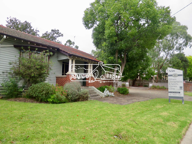
Eltham Gateway, Chiropractors, 856 Main Road, Eltham This Californian Bungalow style house is now the oldest surviving building in this vicinity of Main Road. Previously it was Dave Lyon’s original home and immediately to the right (carpark) was the location of his original motor garage – a tin shed with petrol bowsers out front. When Dave Lyon built a new garage opposite Arthur Street, Charmac Industries then operated out of the tin shed. In early 2021 the house had a new coat of paint and a For Rent sign out frontTomorrow's history documented todayeltham, jim connor collection, main road, eltham gateway, chiropractor, dave lyon house -
 Eltham District Historical Society Inc
Slide, Shillinglaw Cottage, c.1973
Shillinglaw Cottage was relocated in 1963 from its former site a few hundred metres up Main Road to make may for new shire offices built in 1964. It was situated near the Eltham Railway Trestle Bridge on a site that was developed into the Eltham Common. The new Eltham Town Park was constucted opposite on the other side of what was to become Panther Place. In 1993/94 the new Eltham Library was constructed on the Eltham Common. This picture, though out of focus still gives a reasonable impression of the cottage at the time.35 mm colour positive transparency Mount - Kodak Kodachrome Cardeltham common, shillinglaw cottage -
 Eltham District Historical Society Inc
Photograph, The Jelbart Barn, 93 Arthur Street, Eltham, 1972c
Owned at the time by architect, Ian Jelbart, the property had been in the Jelbart family since the 1940s; a 5560sqm secluded hilltop parcel in Eltham. When the manor house and its barn were built, Eltham was a rural community; Jelbart’s grandfather Ronald was a businessman whose poultry farm formed part of the family’s original 100ha holding. A portion would later be subdivided into residential lots to make way for new homes that would form the basis of the Woodridge Estate in the early 1970s. This is a view of the Barn from the main manor house.Digital file only; created from scan undertaken by EDHSarthur street, eltham, houses, jelbart barn, jelbart property, kinloch gardens -
 Eltham District Historical Society Inc
Folder, St Peter's Memorial Church, Kinglake, 1826-1912
The original St Peter’s was built in 1922 as a World War memorial church. It burned down on Black Saturday, February 7, 2009. This folder includes brief research on the local World War One Anzacs of Kinglake remembered at the church including the names Farlow, Ford, Ingham, Jarvis, Lawrey, Mains and North some of whom are remembered on the Shire of Eltham War Memorial at Kangaroo Ground. Also, information how to research WW1 veterans, brochure om Shrine of Remembrance and newspaper article on firespotting at the Kangaroo Ground TowerNewspaper articles, website printouts and handwritten notes HG Booklet 114harry gilham collection, st peter's kinglake, ww1, ford, samuel farlow, john henry ford, jarvis, francis ingham, george mains, c. north, fire spotting, kangaroo ground, shrine of remembrance -
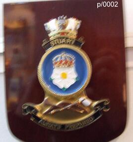 Waverley RSL Sub Branch
Plaque HMAS Stuart, HMAS Stuart
HMAS Stuart (D00), an Admiralty type destroyer leader, launched in 1918 for the Royal Navy. She was transferred to the RAN in 1933, and served during World War II. The ship was paid off in 1946, and sold for scrap. HMAS Stuart (DE 48), one of six River class destroyer escorts (based on the British Type 12 frigate) built for the RAN. She was commissioned in 1963, paid off in 1991, and sold for scrap. HMAS Stuart (FFH 153), an Anzac class frigate commissioned in 2002 and active as of 2012Wooden Plaque 15cm x 13cmHMAS Stuart