Showing 1753 items matching "destroyed"
-
 Bendigo Military Museum
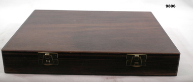
Manual - GOLD COLOUR SAMPLE BOX, c. 1993
This box of sampled is typical of those issued to official manufacturers of military badges, insignia, and buttons to ensure the gold colour remained consistent. These badges were held by the Third Army Quality Assurance Unit (3AQAU). The manufacturers were often local companies, where an example of a typical supplier is KG Luke who also manufactured the Brownlow Medal, the award given annnually to the Australlian Football League's best and fairest player.A rectangular wooden box with a black velvet-like cushion in one side. cushion has 10 examples - 2 of each kind - of military insignia and buttons of two different shades of gold colour. Box opens on one long side and is hinged (4cm brass hinges with 3 screws in each side). Clasps on opposite long side, also of brass. Wood has been stained a dark brown. Base off box shows 14 brass staples. Corners of base show 2 nails, possibly brass. A typed sheet of paper is attached to the inside of lid, dating from 1993, explaining usage of samples. Paper tag affixed to cushion between samples - Department of Defence authenticating samples in box. Tag attached with fabric tape and secured using a lead seal.Paper taped to inside lid - title 'SEALED SAMPLE 8455-03311' - a lengthy description of contents and box follows. Please refer ot photograoph for further details. Typed tag on cushion - 'Department of Defence/SEALED SAMPLE/Sealed sample Number 03311/Stock Number 8455/Description STANDARD OF GOLD COLOUR FOR INSIGNIA, BUTTONS AND BADGES (ANODISED) ALUMINIUM ALLOY 1150/APPROVED. The supply is not to differ from this sealed sample except as endorsed on the back hereof./D Darby [signature] 29/06/1993 /EDE VFE SCDDG [stamped].' Reverse of tag (stamped in red within a thin lined border) - 'SEALED SAMPLE/NOT TO BE/DESTROYED OR/MUTILATED' badges, military insignia, button -
 Chelsea & District Historical Society Inc
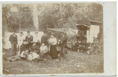
Photograph - Mr Alfred Morton with his brothers and friends, Bike picnic at Morton's property, c 1890
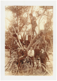
Alfred Louis Morton (known as Louis) was born in Geelong in 1866, the fifth of eleven children of Mark Morton and Eliza nee Heard (married 1898). Alfred began work for the Post Office at South Yarra in the 1890s. In the late 1800s it was common for people from Melbourne and north of the city to travel to Chelsea area beaches for their holidays and many liked the area so much that, like the Mortons, they moved here permanently. In the 1890s Alfred’s sister, Mrs William Ashmore, built a weekend house at the foot of what is now Foy Avenue in Chelsea. The Morton family, including Alfred, visited the area often, camping on the foreshore during the 1890s. In 1911 Alfred moved his family permanently to a house on the corner of Morton Grove and Main Road Chelsea (now known as the Nepean Highway) on property that extended from the main road to the beach. This house was destroyed in the fire of 22 December 1913 which raged amongst the ti-tree on the foreshore between Aspendale and Chelsea. Many buildings were destroyed in this fire. The Argus newspaper reported on Wednesday 24 December that 94 houses were burnt with glowing embers blown a mile and half inland. According to the Argus but for the wide break provided by the Point Nepean Road (now the Nepean Highway) and the railway line, the scrub on the other side might have caught. The Morton children, Elsa and Ivan, attended Chelsea State School (now Chelsea Primary School) and Mrs Morton was active in the establishment of St Chad’s Church of England in Chelsea. At the age of 80 in 1945 Mr Morton was concerned about reports that English children had lost their toys due to the war and so he made (as part of a wider effort in Australia) 100 toy engines that were sent to England. He died in 1946 in Chelsea. Sepia photograph of Mr Alfred Morton with his brothers in law and friend at Carrum in the 1890's, some perched in a tree others grouped at the base of the tree, bikes in the foreground.bike riding, picnic, morton, morton grove, chelsea, carrum -
 Chelsea & District Historical Society Inc
Photograph - Morton Family, Mr Alfred Morton with his mother and aunt, c 1866
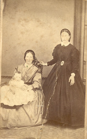
Alfred Louis Morton (known as Louis) was born in Geelong in 1866, the fifth of eleven children of Mark Morton and Eliza nee Heard (married 1898). Alfred began work for the Post Office at South Yarra in the 1890s. In the late 1800s it was common for people from Melbourne and north of the city to travel to Chelsea area beaches for their holidays and many liked the area so much that, like the Mortons, they moved here permanently. In the 1890s Alfred’s sister, Mrs William Ashmore, built a weekend house at the foot of what is now Foy Avenue in Chelsea. The Morton family, including Alfred, visited the area often, camping on the foreshore during the 1890s. In 1911 Alfred moved his family permanently to a house on the corner of Morton Grove and Main Road Chelsea (now known as the Nepean Highway) on property that extended from the main road to the beach. This house was destroyed in the fire of 22 December 1913 which raged amongst the ti-tree on the foreshore between Aspendale and Chelsea. Many buildings were destroyed in this fire. The Argus newspaper reported on Wednesday 24 December that 94 houses were burnt with glowing embers blown a mile and half inland. According to the Argus but for the wide break provided by the Point Nepean Road (now the Nepean Highway) and the railway line, the scrub on the other side might have caught. The Morton children, Elsa and Ivan, attended Chelsea State School (now Chelsea Primary School) and Mrs Morton was active in the establishment of St Chad’s Church of England in Chelsea. At the age of 80 in 1945 Mr Morton was concerned about reports that English children had lost their toys due to the war and so he made (as part of a wider effort in Australia) 100 toy engines that were sent to England. He died in 1946 in Chelsea. Sepia photograph of Mr Alfred Morton as a baby, on the lap of his mother, Eliza, sitting on a chair, and his aunt, standing.morton, mr alfred louis morton -
 The Beechworth Burke Museum
Photograph, 1877
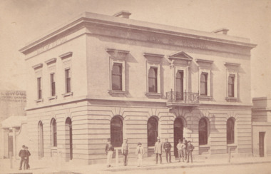
Taken in Beechworth 1867, this photograph depicts the Bank of Victoria on the corner of Camp and Ford Street. This building was erected in 1867 to replace the former bank that was destroyed by a fire on the same site. This classical style structure was designed by architects Smith and Johnson who designed many of the public buildings in Melbourne and Victoria. Arthur Ebden Johnson, 1821–1895 and Alfred Louis Smith, 1830–1907 were appointed as the Bank of Victoria's architects who, in-conjunction with the Branch in Beechworth, also completed branches in Wangaratta and Bendigo. This photograph was taken and produced by the American and Australasian Photographic Company which was founded by Beaufoy Merlin joined by his assistant, Charles Bayliss and Augustus Clinton, and operated between 1866-1873. The company traveled throughout Victoria and New South Wales before establishing a portrait studio in Sydney. There is no apparent connection to America. Sepia rectangular photograph. Image is printed on matte photographic paper and has a white border.Reverse: 1997.2727 (in pencil) Bank of Victoria / Beechworth / 1877 (in pen) Harvey Collection American & Australasian / Photographic Company / Victoria Branch / C. Bayless, Manager No 56beechworth, bank of victoria, american and australasian photographic company, 1877, c.bayless, harvey collection, arthur ebden johnson, alfred louis smith, smith and johnson -
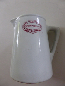 Warrnambool and District Historical Society Inc.
Jug, Lynch's Criterion Hotel Warrnambool, 1920s
This china jug has been made in England by Grindley Hotel Ware. The Grindley company that manufactured earthenware and ironstone items was founded in 1880 by William Grindley and was initially based in Tunstall, Stoke-on-Trent, England. The jug has had a red stamp added so that it could be used at the Criterion Hotel in Warrnambool and identified as the hotel property. The jug was used during the licenseeship of Theresa Lynch. The Criterion Hotel was situated on the western side of Kepler Street near Lava Street, Warrnambool. It opened in 1872 with the first licensee, John Tate. In the 1920s there were extensive renovations to the hotel in the Art Deco style. Theresa Lynch was the licensee from 1919 to 1926. In 1922 she bought the hotel and sold it to Harry McGennan in 1926. In 2006 the Criterion Hotel was closed and it was partially destroyed by fire in 2010 and later completely demolished. This jug is of interest as a 1920s souvenir of the Criterion Hotel, Warrnambool that closed in 2006. This hotel was a prominent one in Warrnambool, known in the 1990s for its promotion of live rock music. This is a white china jug with a circular base slightly tapering to an open top with a spout and handle. On the side of the jug there is a red stamp in the shape of a belt with red lettering. The base has a crown image and the maker’s name.‘Lynch’s Criterion Hotel Warrnambool’ Grindley Hotel Ware, Made in England, Patent’. criterion hotel, warrnambool, theresa lynch -
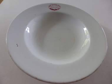 Warrnambool and District Historical Society Inc.
Plate, Humms Criterion Hotel Warrnambool, Early 20th century
This plate has been produced by the English firm of W.H.Grindley for use at the Criterion Hotel in Warrnambool. The Criterion Hotel was on the western side of Kepler street near Lava Street and was established in 1872 with the first licensee being John Tate. The hotel closed in 2008, was partially destroyed by fire in 2010 and was demolished in 2013. The Humm family had a long association with the Criterion Hotel, with George Humm of Woodford taking over as the licensee in 1882 and buying the hotel in 1887 and remaining there until his death in 1894. George Humm’s widow, Elizabeth, was the licensee from 1894 to 1907, her son, John was the licensee from 1907 to 1916 and his widow, Bridget, was the licensee from 1916 to 1919. The plate could have been in use for all or part of these years but is most likely to have been bought early in the 20th century. This plate is of considerable interest because it came from the Criterion Hotel, a prominent hotel in Warrnambool for over 130 years.This is a white china plate which has a red embedded stamp in the shape of a belt (the maker’s trademark) on the front and on the back it has the blue markings of the maker with an image of a crown. The bowl has a shallow base and was perhaps a soup plate. The edges of the plate are somewhat worn and scuffed. ‘Humms Criterion Hotel Warrnambool’ ‘Grindley Hotel Ware England Vitrified’ criterion hotel, humm family of woodford, history of warrnambool -
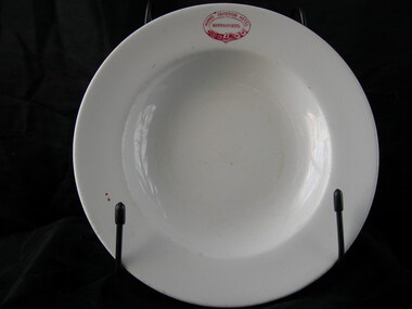 Warrnambool and District Historical Society Inc.
Plate, Humms Criterion Hotel, Early 20th century
This plate has been produced by the English firm of W.H.Grindley for use at the Criterion Hotel in Warrnambool. The Criterion Hotel was on the western side of Kepler Street near Lava Street and was established in 1872 with the first licensee being John Tate. The hotel closed in 2008, was partially destroyed by fire in 2010 and was demolished in 2013. The Humm family had a long association with the Criterion Hotel with George Humm of Woodford taking over as licensee in 1882, buying the hotel in 1887 and remaining there until his death in 1894. George Humm’s widow, Elizabeth, was the licensee from 1894 to 1907, her son, John, was the licensee from 1907 to 1916 and his widow, Bridget, was the licensee from 1916 to 1919. The plate could have been in use for all or part of these years but is most likely to have been bought early in the 20th century. This plate is of considerable interest because it came from the Criterion Hotel, a prominent hotel in Warrnambool for over 130 years. This is a white china plate which has been broken into three pieces and inexpertly mended. The plate is much stained. It has a red embedded stamp in the shape of a belt (the maker’s trademark) on the front and on the back it has the blue markings of the maker with an image of a crown. The bowl has a shallow curved base and was perhaps used for soup. ‘Humms Criterion Hotel Warrnambool’ ‘Grindley Hotel Ware England Vitrified’ criterion hotel, humm family of woodford, history of warrnambool -
 Kiewa Valley Historical Society
Photographs x 2 1. Lake Guy & Bogong Village 2. Bulldozer moving rocks
1. In 1940 Field Headquarters for the Kiewa Scheme were established at Bogong with office, workshop facilities and accommodation for workmen, staff and some families constructed. (There had been a 'tent camp' on this site in 1939 but was destroyed by bushfires) Construction of accommodation continued until 1947. A total of 40 houses plus a hostel for single staff, post office, police station, medical centre and primary school all with water and sewerage and electricity supply. The staff hostel was known as Kiewa House and is now occupied by the Education Department. Lake Guy was named after Mr. L.T. Guy who was the Resident Engineer in charge of construction work and associated activities on the Kiewa area. He held this position from 1939 to November 1946 when he was transferred to Head Office. 2. Example of the type of heavy machinery used in clearing and building of Lake Guy, Bogong Village and Clover Dam 1. The Bogong Township was developed firstly as an accommodation centre (base camp) for construction workers employed under the Kiewa Hydroelectric Scheme. At the completion of the scheme, in the 1960's, the village was opened to public/tourism use. Strict environmental control has not allowed for any extensive redevelopment in tourist accommodation and basically restricted it to the accommodation initially built for the construction workers. Lake Guy is one of the many water storage reservoirs used to supply the power stations their main power to run the huge turbines generating the final product, electricity 2. Pictorial record of the types of machinery used in the development of Bogong Village and the Hydro-electricity scheme including the Clover Dam. Note the lack of safety equipment worn by construction workers of the period. 2 black and white photographs taken at Bogong 1. Lake Guy with Bogong Village in the background 2. Workman in bulldozer clearing rocks, possibly for construction at Bogong1. Handwritten in blue ink on back of photo 'Lake Guy showing Bogong Village' 2. No markingslake guy, bogong village, secv -
 Kiewa Valley Historical Society
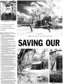
Newspaper article- Double page article. Pages 30 & 83 from the Herald Sun Newspaper. February 18, 2006 regarding preserving Victoria’s High Country Huts
The arrival of explorers Hume & Hovell in 1842 brought about the widespread clearing of land in the valleys for pastoral uses and the displacement the original inhabitants in the high country which became a boon for cattlemen due to extensive lush summer grazing for cattle. High country cattlemen built a variety of huts for shelter and storage, when driving cattle up to the plains in summer, during mustering and bringing the cattle down from the mountains before winter closed in. These same huts now provide shelter from the elements for hikers, bush walkers and skiers. Wallace’s Hut is the oldest of the Cattleman’s huts still standing in the Alpine National Park and is classified under the National Trust. Due to their age and the ravages of the elements, including bush fires, many of the huts have been destroyed, or are falling into disrepair. Groups of willing volunteers are now working to preserve as many of the huts as possible with restoration or rebuilding.The numerous cattleman’s huts of the Alpine National Park and the colourful characters who erected them represent a significant part of the history of the high country area and early cattle grazing, which has been the theme for many poets and film-makers alike. They also have a significant role in the early days of the SECV when they were used by surveyors and other workers for shelter and temporary accommodation. More recently the huts have functioned as shelter for hikers and skiers caught out in the elements and a refuge along the long trek for bush walkers. They are a popular attraction for tourists and feature prominently in much of the tourist information of the region. Black and white double page Newspaper article from the Herald Sun Newspaper of February 18, 2006 regarding the efforts of Mr David Oldfield to preserve Victoria’s remaining High Country Huts through his photography and efforts to restore old and Re-build missing ones. Article shows a photograph of David Oldfield and some of his photographic work of the huts. Page number and date printed at top of each page 30 Herald Sun, Saturday, February 18, 2006 Herald Sun, Saturday, February 18, 2006 83 cattlemen's huts; david oldfield; bogong high plains; wallace's hut; high country; alpine national park -
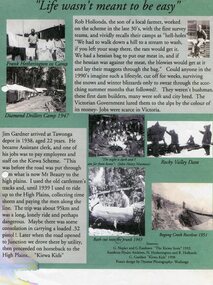 Kiewa Valley Historical Society
Posters – Set of 3 A4 posters depicting the early days and people in the Kiewa Valley
In the 1830’s, European pastoralists started moving south from NSW into the Alps. In 1836, cattle grazing began around Omeo and the runs spread out into the foothills. The higher country was used for summer grazing and huts were built for shelter and storage during stock mustering. The lure of gold brought many people to the Alps from around 1850 to 1900. Bushfires destroyed the forests around Melbourne in 1939 and the boom in house-building after World War II ked to increased demand for timber from the Alps. This resulted in the building of a network of roads which helped open up access to the Alps. The early 1940’s brought the first of many workers to the Alps for the planning and construction of the Hydro-Electric Scheme. These were the pioneers and early settlers of the Kiewa Valley and provided a wealth of characters and a tapestry of stories and adventures to be handed down to future generations.These 3 posters, which were most likely produced for promotional purposes provide a glimpse into the early lives of the pioneer families of the Kiewa Valley through pictures and verse. They show their lifestyle and outline the hardships they had to endure in living and working in the Alpine region. They also highlight the early arguments regarding grazing in the high country which would ultimately lead to the end of the long traditions of the high country cattle men. Set of 3 A4 size posters with black and white photographs and text and colour background depicting various parts of the history of the Kiewa Valley. 1. Titled - ‘Life wasn’t meant to be easy’ Describes early life for Kiewa Hydro workers. 2. Titled - ‘Cattlemen of the High Plains’ Describes a brief history of life of the cattlemen of the high plains 3. Titled – ‘There are Places I’ll remember’ Depicts early photographs of residents of the Kiewa Valley, also includes the words from a John Lennon song as per poster title. Printed on each poster – Poster designed by Dyanne Photography - Wodonga 1. Printed at bottom of poster – Sources: G Napier and G Easdown “The Kiewa Story” 1993. Southern Hydro Archives, N Hetherington and R Hollands. G Gardner “The Kiewa Kids” 1998. 2. Printed at bottom of poster – Sources: D Purland. Handwritten at top of poster- Poster 4 3. Printed at bottom of poster – Sources: B Roper, W Davies, D Higginson, H Ryder. Handwritten at top of poster- Poster 3 kiewa valley; tourism; lifestyles -
 Eltham District Historical Society Inc
Photograph - Black and White Print, Hector John McLean, Louisa Frances McLean (nee Green), 1934, 1934
The McLean family, Hector John McLean and Louisa Frances (nee Green) and six daughters lived in Eltham during the period 1930 to 1934 inclusive. Lived in the former Evelyn Hotel at the time it was destroyed by fire in 1931. In reminiscences provided by daughter Edith, she recalls that her mother always blamed herself for the fire. When she finished cooking on the old wood stove she would always clean up and take the ashes outside in an ash pan to bury them for safety. She believed she must have dropped some oas she walked across the back verandah or the breeze caiught some sparks as she opened the door. It was a very hot day. She believed that they must have fallen down some cracks in the floor boards and smouldered on papers and rubbish in the cellar. It proved to be a very traumatic event for the family.louisa frances mclean (nee green), fountain hotel, evelyn hotel -
 Mission to Seafarers Victoria
Photograph, French sailors at zoo - Madame Lion & Miss Godfrey, 1917
Marie Lion migrated with her sister, Berthe Mouchette and her husband in 1885. Berthe established an art school in the city. After the death of her husband the sisters purchased a school, Oberwyl, in St Kilda in 1885. The school was later one of the LHLG schools. Berthe was the founder of the Alliance Française of Melbourne in 1890. With the Great Depression, the sisters had to sell Oberwyl and moved to Adelaide. They returned to France during WWI to nurse wounded soldiers. And returned to Adelaide in 1916 after Marie contracted an infection. She was the South Australia representative of the "Société d’assistance maternelle et infantile". After the end of the war a number of French villages were ‘adopted’ by cities in Australia. Dernancourt, a small village in the Somme was adopted by Adelaide, and Mme Mouchette and Mme Lion worked to raise funds to help in the rebuilding of the almost completely destroyed town.The picture shows the link with the French community. Ethel and her sister Frederica Godfrey could speak French and were well acquainted with the members of this community: Charlotte Crivelli for example. Frederica was secretary of the Alliance Française of Melbourne in the early 1900, in 1917 she also became Honorary Secretary of the French Red Cross, funded by Charlotte Crivelli.Portait of two ladies standing in the middle with 3 soldiers from the French Navy, a wounded digger and a young man.French sailors at zoo / Madame Leon (Lion is the correct spelling) & Miss Godfreylion, marie (1855–1922), mouchette, berthe (1846–1928) nee lion, alliance française of melbourne, société d’assistance maternelle et infantile, france, french, zoo, french red cross, crivelli, charlotte (1863–1956), anzac, french navy, oberwyl, ethel augusta godfrey 1861-1935, frederica godfrey -
 Eltham District Historical Society Inc
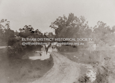
Photograph, Diamond Creek in flood over Glen Park Bridge, Eltham, c. 26 August 1924
Significant flooding of the Diamond Creek occurred in Eltham and Glen Park on Tuesday, August 26, 1924 with several houses swamped and all bridges covered except the Greensborough Road Bridge. [Houses at Eltham Flooded. (1924, August 27). The Argus (Melbourne, Vic. : 1848 - 1957), p. 19. Retrieved from http://nla.gov.au/nla.news-article4156891] The Glen Park Bridge was originally built as a replacement for an older private bridge built by a man named Foley around 1880. In 1911 Heidelberg and Eltham agreed to share the costs to build a new bridge. Construction began in June 1915 and it was officially opened by Cr. Taylor on Cup Day, November 1915. The bridge was destroyed by floodwaters in the afternoon of 20 September 1959 during construction of the new Wattletree Road bridge. The new bridge west embankment joined the existing road at approximately where the bend in the road is situated in the photograph.Colour photograph of originalfloods, eltham, diamond creek (creek), egan's crossing, eltham-diamond creek road, glen park bridge, glen park road -
 Warrnambool and District Historical Society Inc.
Document Warrnambool Woollen Mill, Loose sheets Production analysis 1937-1938, 1937
In 1869, the Warrnambool Meat Preserving Company commenced their business on the site, where it operated until 1875 when it was sold to the directors of the Warrnambool Woolen Mill Company. After being destroyed by fire in 1882 it wasn’t until 1910 that the Warrnambool Chamber of Commerce was approached by Marcus Saltau and Peter McGennan to invest in a new mill. The original directors were James Dickson, P J McGennan, Robert Swinton, M Saltau, and J W Younger. In 1955 the Warrnambool Woollen Mill formed a partnership with the Wangaratta Woollen Mills. Dunlop bought the mill in 1968. From that time until its closure in 2000 it had a number of different owners, the last being the Smith Family Industries. These sheets provide data relating to sales of various different blankets in colours and sizes and where sales occurred . All the capital cities are listed with quantities and customer numbersThe woollen mill was one of the major industries of Warrnambool for nearly100 years. This document is one of many in the collection of the Warrnambool and district historical society which gives an insight into the scale and type of production during the 20th century.Rectangular bundle of loose pages with card on either side and held together with string. Pages are lined and typed with data and also have two small holes and one elongated hole stamped between the smaller ones.Analysis Season 1937-1938 written in red pencil on front card. 'These sheets stocked in 25 patterns by peacock Bros Pty Ltd Melbourne Sydney Adelaide Perth and Brisbane. When ordering this pattern specify No D5' printed on each of the paper sheets.warrnambool, warrnambool woollen mill, woolen mill, dunlop olympic, marcus saltau p j mcgennan james dickson, robert swinton j w younger, wangaratta, dreamspun -
 Eltham District Historical Society Inc
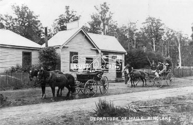
Negative - Photograph, Departure of Mails, Kinglake, c.1908
Reproduced on p73 of 'Pioneers & Painters' Two horse drawn carriages outside Thomson's hotel in Kinglake. One is carrying passengers. On the left attached to the hotel is the Post Office. Mrs Thomson was the postmistress who in 1927 had held the position for 43 years (since 1884). The licence for the house was obtained in 1908 by Mr. Harry Thomson who by 1927 was the oldest permanent resident in Kinglake, having been there about 50 years. The hotel was destroyed by bushfire in February 1926 and a new hotel constructed on the site in 1927 by owner and licensee, Mr Frank Thomson, Harry’s son. Another identity at the hotel is Mr W. S. Harris, better known as "Shelley” who was the ranger at Kinglake National Park but also served in the Boer War and World War 1 having got away after being rejected ten times, at the age of 55 years.This photo forms part of a collection of photographs gathered by the Shire of Eltham for their centenary project book,"Pioneers and Painters: 100 years of the Shire of Eltham" by Alan Marshall (1971). The collection of over 500 images is held in partnership between Eltham District Historical Society and Yarra Plenty Regional Library (Eltham Library) and is now formally known as 'The Shire of Eltham Pioneers Photograph Collection.' It is significant in being the first community sourced collection representing the places and people of the Shire's first one hundred years.Digital image 4 x 5 inch B&W Neg 9 x 12.5 cm B&W printsepp, shire of eltham pioneers photograph collection, kinglake, mail coach, thomson's hotel, kinglake hotel, postal service, passengers, transport, frank thomson, harry thomson, shelley harris, post office -
 Federation University Historical Collection
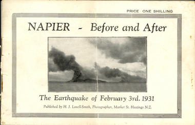
Booklet, Nelson Stedman, Napier Before and After the Earthquake of February 3rd 1931, c1931
The earthquake at Napier, also known as the Hawke's Bay Earthquake, took place on 03 February 1931 at about 10.45 am. There was no warning before the ground started to heave and roll in waves. It was not possible to stand without support, and the violent motion caused stone and brick buildings to collapse into the streets causing death and injury to hundreds who were going about there daily business. Fires started almost immediately, and with the water mains shattered, the fire fighters were powerless to stop or prevent the spread of the flames. Within twelve hours the greater part of the business area of Napier and its port was totally destroyed. As a result of the pressure which caused the upheaval, the levels of the town and the surrounding district have been altered. The town and the harbour were raised from five to seven feet, and many parts of the inner harbour became dry land. Small booklet of 18 pages with photographic comparisons of New Zealand's Napier region before and after the 1931 earthquake.napier, new zealand, earthquake, lovell-smith, stedman, boston, port ahururu, westshore, clive square, hawke's bay -
 Federation University Historical Collection
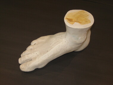
Sculpture - Plaster Drawing Prop, Cast of Foot, before 1918
The Ballarat Technical Art School boasted a well-stocked Antique Room replete with plaster copies of classical, Renaissance and Gothic sculptural examples, which were used as drawing props by students. The school inherited some casts from its predecessor institutions, and further consignments were purchased during the 1920s, including full length, bust and relief figures, as well as dozens of ornamental and architectural casts. Unfortunately, much of the collection was lost or destroyed in the late 1950s. This is one of the few surviving pieces. The foot came into the school’s collection prior to 1920 as it appears in a photo in the SMB Annual Report. There are two possibilities where these sculptures may have originated, either Victorian and Albert Museum or the British Museum. There is a reference to the purchase of plaster casts from the Victoria and Albert Museum in the 1918 School of Mines Ballarat Minute Book. This plaster cast of a foot is of local significance as only one of a few remaining teaching pieces from the substantial collection of sculptures used in the art school. The foot also has significance as an interpretive tool complementing the complete art folio of Edith Alice Watson who was a student from 1930-1933.Plaster cast of right foot including ankle. Made from plaster of Paris. Mainly white in colour with grey patches around metatarsels, flecks of blue and green paint and pale brown paint (possibly shellac) and on top of ankle. Measurements suggest a size 11 man's right foot.plaster cast, foot, drawing aid, art school, smb, edith alice watson, 1931, 1931-33, 1918, 1920, plaster of paris, sculpture, ballarat technical art school number 10, drawing from the antique, drawing the human figure from cast -
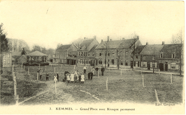 Federation University Historical Collection
Postcard - black and white, Kemmel, France, c1916, c1916
Holmes Family WW1 memorabilia Kemmel village is around six miles south-west of Ypres. Located just to the north of the village centre is Kemmel Chateau Military Cemetery. The cemetery was established early in the war, in December 1914, taking its name from Kemmel Chateau which stood to the rear of the cemetery location. The chateau at certain stages in the war housed an Advanced Dressing Station (ADS), and the cemetery continued to be used until March 1918, when Kemmel was taken by the Germans. Although it was retaken later on that year, both the cemetery and the chateau suffered from shelling with the chateau being destroyed. In total there are 1,135 First World War soldiers buried here, all but three being identified. In addition, located in a row on the left by the entrance are 21 Second World War burials. http://www.ww1battlefields.co.uk/flanders/kemmel.html, accessed 11/07/2014)Two black and white postcards showing Kemmel, France. .1) Grand'Place avec Kiosque permanent .2) Le Belvedere et le Moulinchatham-holmes family collection, kemmel, france, world war one, postcard -
 Victorian Interpretive Projects Inc.
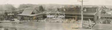
photograph, Opening of the bew building at Stratford Railway Station, Victoria, c1921, c1921
Stratford railway station is located on the Bairnsdale line in Victoria, Australia. The railway lined opened on 8 November 1887 it served the town of Stratford. The building at the Stratford Railway Station was opened around 1921 after the original building was destroyed by fire on 10 January 1920. "STRATFORD RAILWAY STATION. Mr. M'Lachlan, M.L.A., has received the following from Mr. Norman, late Chairman of the Railway Commissioners:-"In reply to yours, I beg to state that material for the new Stratford railway station has been ordered, and the work will be put in hand as soon as it has been delivered. It is not an easy matter at the present time to obtain materials, and I cannot say exactly when those required will be received." (Gippsland Times, 27 September 1920) Until their demolition, Munro, Fernbank, Lindenow and Hillside stations were located between Stratford and Bairnsdale stations. (wikipedia)Photograph of two postcards showing a crowd at Stratford Railway Station to celebrate the opening of the new building. stratford, stratford railway station, railway -
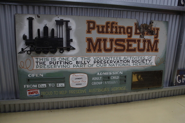 Puffing Billy Railway
Sign - Puffing Billy Museum Entry
The Museum was first considered in 1963 when it was felt that Victorian narrow gauge railway history was quickly being destroyed by progress. Originally it was planned to only cater for two locomotives and some rolling stock associated with the Moe and Walhalla Railway. Construction of the site commenced on Labour Day Weekend in March 1964, the area was then fenced. The first exhibit arrived soon after and companies with locomotives and other railway features offered items to the Museum. When interesting exhibits from the "Steam Era " were known to be coming available,discussions were held with the owners in an attempt to obtain the item for preservation. In 1965 an Umbrella style shed was built and by May, the first locomotive ex Erica State Saw Mill (CLIMAX) had arrived. The Museum was opened to the public in November 1970 but was officially opened by His Excellency the Governor of Victoria, Sir Rohan Delacombe on Saturday 7th April 1973.Historic - Puffing Billy Museum Entry SignPuffing Billy Museum Entry Sign Rectangular hand painted sign in use from 1970.Puffing Billy Museum This is one of the Volunteer activities of The Puffing Billy Preservation Society Preserving part of our National Heritage Proud to Help Preserve Australia's Heritage puffing billy, menzies creek, sir rohan delacombe, narrow gauge, steam -
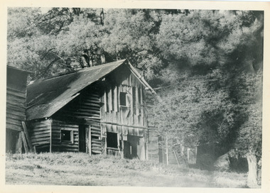 Mt Dandenong & District Historical Society Inc.
Photograph, Isaac Jeeves' Barn
Large barn built c1886 by Isaac Jeeves the younger on his property where the homestead 'Shiloah' stood. The barn was reputedly made from timbers split from only one messmate tree. Originally the home of Isaac Jeeves, brother of Ellis Jeeves, ‘Shiloah’ was enlarged to take guests in the early 1900s. It was situated close to a beautiful fern gully and Isaac and his family capitalised on this by setting out walking tracks through the ferns. They charged 1/- to walk through and this included afternoon tea in a garden setting. ‘Shiloah’ was a popular tourist attraction but the making of the Olinda Creek Road destroyed the fern gullies and, by the 1930s, it was all finished. John Lundy-Clarke grew up in the Kalorama/Mt Dandenong area and later in life (1972-74) began to write a comprehensive history of the area working from an original settlement map in an effort to cover all areas.Black and white photograph showing a large wooden structure surrounded by trees. Handwritten inscription on reverse by John Lundy-Clarke.Home of Isaac Jeeves the younger. Built about 1886 of timbers split from one messmate tree. Photo 1973isaac jeeves the younger, barn, kalorama, shiloah, messmate -
 Vision Australia
Administrative record - Text, VABW Entertainment Committee minutes: 9/11/1926 - 7/3/1940 and Annual Report of Entertainment Committee 1934-1935 and 1935-1936, 1926-1940
Victorian Association of Braille Writers had subcommittees including the 'Entertainment Committee' which organised concerts, lectures including fortnightly socials and dances throughout the year. These minutes contain information on attendees, meeting chair, apologies, minutes acceptance, matters arising from the minutes, accounts, reports, matters arising from reports, donations, general business and the date of the next meeting. This minutes includes a copy of the 41st & 42nd Annual Report 1935-1936 of the Entertainment Committee it noted that the Boat House, which was the gift of Mrs Cecil Macmeikan 10 years ago, was wholly destroyed during the storm in November however was repaired the next year. The Boat House has been a wonderful source of pleasure for day trippers, and many picnics have been arranged, enabling the blind to meet their friends and have an outing at the seaside at a nominal cost. 1 volume of handwritten pagesvictorian association of braille writers, recreation, boat house -
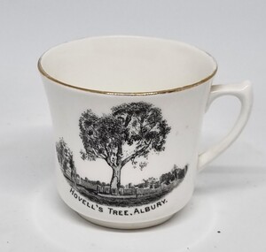 Wodonga & District Historical Society Inc
Souvenir - Cup Hovell's Tree, Albury
This souvenir represents the Hovell Tree, a local historic landmark in Albury, NSW. This item is from a collection donated by descendants of John Francis Turner of Wodonga. The Hovell Tree commemorates the exploration and naming of the Hume River (now the Murray) by Hume and Hovell`s expedition of 1824. In 1824, Governor Brisbane asked Hume to join forces with an English sea captain, William Hovell, to go from Lake George to the Spencer Gulf in South Australia. The Hovell Tree, marked by William Hovell on November 17, 1824 was flanked by another tree marked by Hamilton Hume which was destroyed by fire in the 1840's. The river gum was marked by William Hovell when discovering river. Hume and Hovell travelled from the Yass area and after crossing the Murray River where Lake Hume now is, they crossed the Mitta Mitta River and proceeded to Corio Bay, Westernport.This item is representative of souvenirs produced to represent key buildings and historic landmarks in the Albury-Wodonga district.A white cup with gilt trim around the lip. It bears an image of the Hovell Tree in Albury, NSWBeneath image: "HOVELL'S TREE, ALBURY."albury souvenirs, hovell tree, hume and hovell, australian exploration -
 Bendigo Historical Society Inc.
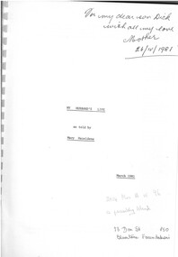
Book - MY HUSBAND'S LIFE - AS TOLD BY MARY HAZELDENE, 1981
Sydney Herbert Hazeldene (1893-1966) was born in Bath, England and arrived in Australia in 1906. HE walked for 10 days from Melbourne to Bamawm, where he found work on a dairy farm. After 3 years he walked to Eaglehawk where he found work as a wheeler in a mine. He served in WW1 at Gallipoli, where he was wounded. After his return to Bendigo he married Mary Eales and they began a successful bus service. Unfortunately their two buses were destroyed by fire so they purchased a truck and began a removalist/carrier business serving locally and interstate. When the work became too heavy for Sydney he bought land and set up a dairy farm. They also moved into breeding chickens and soon this business overtook the dairying with the last cows sold in 1942. This was the beginning of Hazeldene's Poultry.Softcover book white front with black printed title. Memoir of 58 pages recounting author's husband's (Sydney Herbert Hazeldene) life. Inscribed on front cover 'For my dear son Dick with all my love Mother 26/11/1981'Mary Hazeldenebooks, biography -
 Bendigo Military Museum
Postcard - PHOTOGRAPHIC POSTCARDS WW1, 1915 - 1919
Items in the collection relating to C.J.C. McQuie MM, refer Cat No 9680P for his service details. .1) The card is to McQuie’s Mother, in pencil “Postcard views of Eygpt only”. .2) on rear in purple Talks about the area being owned by a Countess and wanting to keep it in its natural state. .3) On rear in black, “A very pretty site from the hills above”. 4.) On rear in black, “Another view from Hursborough”. .5) On rear in blue, “Talks about the Church being designed by Christopher Wren & was destroyed by fire in1675”. .6) On rear in purple, “I could not get them all in the one envelope, C. McQuie MM”. .7) Addressed to McQuie’s Father, in blue pen, “Talks about having a good time & card signed y a German girl, C.H. KKylre? And a traveller with him, A.J. Terry Lieut AIF”Seven postcards, diffferent tones, none dated, all with text on rear. .1) B&W scene of buildings & palms in Eygpt. .2) Sepia tone view over Clovelly from Hobby Drive. .3) Sepia tone View Lee Bay Ilfracombe. .4) Sepia tone view Ilfracombe, Chamber Combe Valley. .5) Sepia tone scene All Saints Church Northampton. .6) Sepia tone scene St John’s Convalescent Home Northants. .7) Colour drawing, on the Rhine, red stamp on.postcards, photos, mcquie -
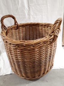
 Vision Australia
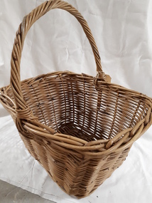
Functional object - Object, Cane basket with handle
Basket weaving and brush making was a source of income for those who worked in the workshops at RVIB and other institutions in New South Wales and Queensland. A diverse range products could be produced with cane, such as cane chairs, cots, washing baskets and trolleys, and the Institution sought to highlight these in the annual report. Over time the demand for, and supply of, cane changed - particularly during World War 2 when Asian sources were under attack or destroyed. At home, other materials such as plastics as well as the ability to import cheaper pre-produced products further reduced the demand for workshop pieces. Generic style basket that would have been used for shopping or any household task requiring movement of multiple items. Cane baskets were the original green alternative to plastic shopping bags. Note that the handle is deliberately askew, for easier carrying against the hip.1 cane basket with askew handleemployment, royal victorian institute for the blind -
 Vision Australia
Functional object - Object, Cane basket with handles and reinforced base
Basket weaving and brush making was a source of income for those who worked in the workshops at RVIB and other institutions in New South Wales and Queensland. A diverse range products could be produced with cane, such as cane chairs, cots, washing baskets and trolleys, and the Institution sought to highlight these in the annual report. Over time the demand for, and supply of, cane changed - particularly during World War 2 when Asian sources were under attack or destroyed. At home, other materials such as plastics as well as the ability to import cheaper pre-produced products further reduced the demand for workshop pieces. This cane basket was used for storage as well as transporting heavier items. The base has been reinforced with two thick boards that allow the basket to hold more weight than regular baskets, and this also allows it to sit higher and the contents slightly above ground level.1 deep cane basket with two side handlesemployment, royal victorian institute for the blind -
 Eltham District Historical Society Inc
Photograph, Wendy Wilson, Our Lady Help of Christians Primary School, 1-13 Henry St, Eltham, c.1980
Our Lady Help of Christians Primary School - The hall on the left side was the original Our Lady Help of Christians Church which was built c.1962 on the site of the former weatherboard St Mary's Church which was destroyed by fire in 1961. A new church was erected on the opposite (southern) side of Henry Street in 1976, partially on the original Lot 20 Henry Street of Holloway's Little Eltham North estate. Lot 20 Henry Street was the site of the former Wesleyan Church chapel in the 1850s which also used by David and Catherine Clark to establish their first school in 1855 prior to the erection of the Dalton Street school in 1856. The chapel was replaced by a new building, the Eltham Rechabite Hall (1893-1921) which then became the Eltham Public Hall (1922-1940). The Eltham Fire Station was also situated adjacent from 1931 to 1935. our lady help of christians primary school, henry street, eltham -
 Wooragee Landcare Group
Photograph, 5 September 2004
Wooragee Landcare Group took a bus trip Sunday 5th September to Samaria, Tatong area (near Benalla) to look at land use on small farms. Around this time, Wooragee Landcare were looking into how small land holders could run some enterprises. This photo was taken at Tatong Tavern where the group had lunch. The Tatong Tavern is an old English style pub situated in the foothills of the Great Dividing Range the small community of Tatong 23km south-east of Benalla. The original weatherboard hotel was originally built in the 1880s by William Worrall who was listed as Hotel Keeper from 1886 to 1910. It was destroyed by fire in 1923 and replaced by the current building, which has undergone many changes over the past 100 years. The name has also changed from the Tatong Hotel or ‘Pub’ to the current name of Tatong Tavern.Tatong is a rural village in north-east Victoria, set in undulating country that rises southwards to the Tolmie ranges. The name is thought to derive from an Aboriginal expression, possibly referring to something unseen. The Tatong pastoral run was taken up in 1847 and farm selections began in the 1870s. A school opened in 1890 (closed in 2006). Dairy herds were grazed on the Tatong flats and a cooperative creamery operated from 1892 until 1918. In 1914 a branch railway line was opened from Benalla to Tatong that carried farm produce and timber to Tatong, which had two sawmills in the 1920s. There was also a general store, a police station, and a livestock trucking yard. St Albans Church of England was built in 1921. Most of those buildings have now disappeared. The Tatong Tavern along with the Hall built in 1904 are the only remaining buildings. The Tatong Tavern is a significant tangible and visual representation of the area’s cultural and social history over the past 100 years. Coloured rectangular photograph printed on paperReverse: WAN NA E0NA2N2. NNN- 14240/ (No. 20) 373/ tatong, tatong pub, tatong tavern, tolmie ranges, tatong flats, benalla, wooragee landcare, wooragee landcare group, bus trip, samaria, land use, william worrall, 1800s, 2004, mount samaria -
 Chelsea & District Historical Society Inc
Photograph - Camping at Carrum, Morton Family, c 1890's
Mr Alfred Morton with his sisters, brothers and friends camping at Carrum in the 1890's. This area was later called Chelsea. Alfred Louis Morton (known as Louis) was born in Geelong in 1866, the fifth of eleven children of Mark Morton and Eliza nee Heard (married 1898). Alfred began work for the Post Office at South Yarra in the 1890s. In the late 1800s it was common for people from Melbourne and north of the city to travel to Chelsea area beaches for their holidays and many liked the area so much that, like the Mortons, they moved here permanently. In the 1890s Alfred’s sister, Mrs William Ashmore, built a weekend house at the foot of what is now Foy Avenue in Chelsea. The Morton family, including Alfred, visited the area often, camping on the foreshore during the 1890s. In 1911 Alfred moved his family permanently to a house on the corner of Morton Grove and Main Road Chelsea (now known as the Nepean Highway) on property that extended from the main road to the beach. This house was destroyed in the fire of 22 December 1913 which raged amongst the ti-tree on the foreshore between Aspendale and Chelsea. Many buildings were destroyed in this fire. The Argus newspaper reported on Wednesday 24 December that 94 houses were burnt with glowing embers blown a mile and half inland. According to the Argus but for the wide break provided by the Point Nepean Road (now the Nepean Highway) and the railway line, the scrub on the other side might have caught. The Morton children, Elsa and Ivan, attended Chelsea State School (now Chelsea Primary School) and Mrs Morton was active in the establishment of St Chad’s Church of England in Chelsea. At the age of 80 in 1945 Mr Morton was concerned about reports that English children had lost their toys due to the war and so he made (as part of a wider effort in Australia) 100 toy engines that were sent to England. He died in 1946 in Chelsea.Sepia photo of members of the Morton family camping at Carrum (now Chelsea). Tents and a wagon in the backgroundmorton, chelsea, carrum, post office, south yarra, camping, tents, wagon