Showing 2393 items
matching charles street
-
 Kew Historical Society Inc
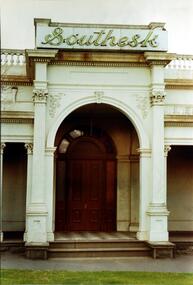
Photograph, Entrance to ‘Southesk’, Cotham Road, 1970
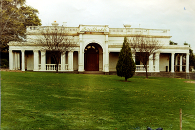
... in 1882 on the corner of Cotham Road and Charles Street... on the corner of Cotham Road and Charles Street. This Italianate mansion ...Colour enlargement of a photograph (slide) of Southesk (formerly Ordsall) in Cotham Road, Kew (demolished 1970).Rare colour photograph of the exterior of SoutheskA colour enlargement of the entrance to ‘Southesk’. Formerly known as ‘Ordsall’, the house was built for John Halfey in 1882 on the corner of Cotham Road and Charles Street. This Italianate mansion was built in the Renaissance villa style on a bluestone plinth. The picture provides photographic evidence of the tiling on the veranda and the typically arched doorway. The neon sign above the door was added during the period when it was owned by the City of Kew (1948-70).david carnegie, john halfey, southesk - cotham road - kew (vic), ordsall - cotham road - kew (vic) -
 Ringwood and District Historical Society
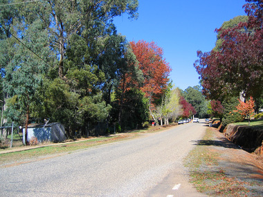
Flyer, Land Sale Advertisement - State School Estate, Ringwood, Victoria - 1923
... Locality plan includes King Street and Government Roads..., and Charles Street). (Agents) J.B. McAlpin, Estate Agent ...The date of the flyer as circa 1920 can be estimated from the references to the (decision on) "electrification of the Croydon Railway Line" which eventually occurred in 1923, letting of tenders for the state school building which opened in 1924, and the "proposed new railway station" (East Ringwood) which opened in 1925, Advertisement for State School Estate, Ringwood - 26 residential allotments for sale near East Ringwood State School development site and 7 minutes walk from proposed new railway station (East Ringwood). Includes location map and terms of sale.Locality plan includes King Street and Government Roads (Later Everard Road, Holland Road, Purser Avenue, and Charles Street). (Agents) J.B. McAlpin, Estate Agent and Subdivisional Manager, Ringwood (Opposite Station), and F.V. Parker, Estate Agent, Main Street, Ringwood. -
 Mission to Seafarers Victoria
Furniture - Altar, Rodney Howard Alsop, 1907
... plaque in memory of Charles Shuter, a colonist and police ...Along with the pulpit, this Altar was designed by architect Rodney Howard Alsop (1881-1932) (Annual report 1908). It was originally made for the Siddeley Street Institute, which was built in 1907 on a block of land leased from the Melbourne Harbour Trust and donated by Mrs Amelia Shuter (nee Lord) (see Annual Report 1907). The altar is photographed in an early picture of the Siddeley Mission in a room used as chapel before the chapel built in 1909. Although a 21 year lease for the site had been granted, a notice was delivered to the Mission to quit the site in 1912. In 1915, the present site was agreed on. The Altar sits within the Chapel of Saint Peter, which belongs to the State Heritage listed (H1496) Mission to Seafarers Victoria complex. This complex was designed by Walter Richmond Butler in 1916, and officially opened on 11 September 1917. On the right hand side of the altar, is a brass plaque in memory of Charles Shuter, a colonist and police magistrate who died in 1902. The plaque was made in 1907.The Altar is significant because it is located within the Memorial Chapel of Saint Peter, forming part of the State Heritage listed Mission to Seafarers Victoria complex. It is of religious significance in catering for all denominations and the spiritual needs of visiting seafarers.The Altar has a shelf above and three panels along the front, with carved decoration and lettering. Altar bears a plaque that reads "To the Glory of God - In memory of Charles Shuter, of Melbourne, Police Magistrate, Given by his Wife, December 13th 1907". Carved letters "MTS" in centre of three panels along front of Altar, and "HOLY, HOLY, HOLY" in three panels below shelf on top of Altar.altar, mission, seafarers, seamen, melbourne, victoria, charles shuter, siddeley street institute, chapel, australian timber, walter richmond butler, australian maritime history, rodney howard alsop (1881-1932), saint peter chapel, communion table, amelia shuter nee lord, heritage listed, gifts-1917 -
 Glen Eira Historical Society
Article - Shoobra Road, 63, Elsternwick
... Street Charles... House names Elsternwick Wymswold Verandahs Street Charles ...3 items on 63 Shoobra Road: 1/An advertising article dated 19/03/2004, from Property Review Weekly, giving details of original features and renovations done to 63 Shoobra Road, for forthcoming auction by Gary Peer. 2/Handwritten research by Claire Barton on 63 Shoobra Road giving house name in the 1910 Sands & McDougalls and owner/tenant, dated 30/09/2011. 3/An auction advertisement for 63 Shoobra Road on 06/12/2014 (newspaper add hand-dated as 11/11/2014).shoobra road, real estate agents, house names, elsternwick, wymswold, verandahs, street charles, fireplaces, architectural features, cast iron work, marble, gary peer & associates, stables, bay windows, carports -
Glen Eira Historical Society
Document - Hopetoun, Hopetoun Street, 2, Elsternwick
... the Caulfield Rate Books 1891 suggesting that Charles Webb is likely ...3 items related to this property: 1/One page of typed notes, undated and unattributed, from the Caulfield Rate Books 1891 suggesting that Charles Webb is likely to be the architect of Hopetoun. 2/One page of handwritten notes, undated and unattributed, detailing the architectural features of the Hopetoun Private Hospital. 3/One page of handwritten notes, undated, signed by R E Ballantyne providing a reference to a thesis 'Charles Webb Early Melbourne Architect' for the University of Melbourne's School of Architecture 1967, by John Denton and Barrie Marshall. Reference is for Photo 65 contained there which includes a may be a photograph of Hopetoun.hopetoun, webb charles, architects, hopetoun street, caulfield, architectural features, towers, verandahs, denton john, marshall barrie, private hospitals, elsternwick, hopetoun private hospital, hopetoun avenue, ballantyne r e, 'charles webb early melbourne architect', denton john, marshall barrie, school of architecture university of melbourne -
 Marysville & District Historical Society
Photograph (Item) - Colour photograph, Unknown
... bushfires. Lyell Street was named after Charles Lyell. Charles Lyell ...A colour photograph of Forester's Cottage at 44 Lyell Street in Marysville in Victoria.A colour photograph of Forester's Cottage at 44 Lyell Street in Marysville in Victoria. This building, along with most of the buildings in Marysville, was destroyed in the 2009 Black Saturday bushfires. Lyell Street was named after Charles Lyell. Charles Lyell was a Scottish geologist who demonstrated the power of known natural causes in explaining the earth's history.charles lyell, lyell street, marysville, victoria, 2009 black saturday bushfires, photograph -
 Marysville & District Historical Society
Photograph (Item) - Colour photograph, Travel Victoria, 2004
... Black Saturday bushfires. Lyell Street was named after Charles ...A colour photograph taken in Lyell Street in Marysville in Victoria.A colour photograph taken in Lyell Street in Marysville in Victoria. This residence was one of the few in Marysville that survived the 2009 Black Saturday bushfires. Lyell Street was named after Charles Lyell. Charles Lyell was a Scottish geologist who demonstrated the power of known natural causes in explaining the earth's history.charles lyell, lyell street, marysville, victoria, 2009 black saturday bushfires, photograph -
 Marysville & District Historical Society
Photograph (Item) - Colour photograph, Travel Victoria, 2004
... Street was named after Charles Lyell. Charles Lyell ...A colour photograph taken in Lyell Street in Marysville in Victoria.A colour photograph taken in Lyell Street in Marysville in Victoria. Lyell Street was named after Charles Lyell. Charles Lyell was a Scottish geologist who demonstrated the power of known natural causes in explaining the earth's history.charles lyell, lyell street, marysville, victoria, photograph -
 Marysville & District Historical Society
Photograph (Item) - Colour photograph, Unknown
... Saturday bushfires. Lyell Street was named after Charles Lyell ...A colour photograph taken in Lyell Street in Marysville in Victoria.A colour photograph taken in Lyell Street in Marysville in Victoria. All three of the residences in this photograph were destroyed in the 2009 Black Saturday bushfires. Lyell Street was named after Charles Lyell. Charles Lyell was a Scottish geologist who demonstrated the power of known natural causes in explaining the earth's history.charles lyell, lyell street, marysville, victoria, 2009 black saturday bushfires, photograph -
 Marysville & District Historical Society
Photograph (Item) - Colour photograph, Unknown
... Saturday bushfires. Lyell Street was named after Charles Lyell ...A colour photograph taken in Lyell Street in Marysville in Victoria.A colour photograph taken in Lyell Street in Marysville in Victoria. Both of these residences in this photograph were destroyed in the 2009 Black Saturday bushfires. Lyell Street was named after Charles Lyell. Charles Lyell was a Scottish geologist who demonstrated the power of known natural causes in explaining the earth's history.charles lyell, lyell street, marysville, victoria, 2009 black saturday bushfires, photograph -
Glen Eira Historical Society
Document - St. Christopher’s Anglican Church, Bentleigh East
... Road Uniting Church Kenny Charles Rev. Cecil Street Cottier ...4 items: 1/Three parish newsletters dated May 1957 and December 1959, and Christmas 1959, and undated. Newsletter about fundraising for new church building completed in 1969. 2/Three Christmas church service details for 1979, 1984, one undated and one for 09/05/2010. 3/Photocopy of booklet dated 1977 celebrating 25 years of the church and list of invitees and 2002 celebration of fifty years of the church and order of service dated 08/09/2002, and photocopy of recollections, handwritten, by Mrs. Iris Fowler in 2002 of her years as a parishioner. 4/Two pages of names of St. Christopher’s Pioneers, handwritten, dated 24/07/2012 by Clare Barton. Newsletters all contain lists of officials and various parishioners, and advertisements by local businesses, and lists of all ministers and curates.st. christopher’s church of england, centre road, mackie road, bentleigh east, chambers david h. rev., green laurie v. rev., st. john’s church of england, glasscock geoffrey t. rev., brady road church of christ, brooker burne, east boundary road, north road, bignell road, south oakleigh uniting church, st. peter’s catholic church, east boundary road uniting church, kenny charles rev., cecil street, cottier john rev., poole tony, churches, anglican church, church services, church festivals, christmas, sunday schools -
 Yarra Glen & District Historical Society
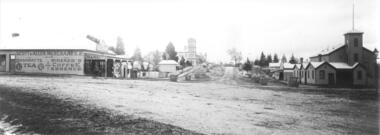
Black and white photographs, Bell Street Yarra Glen looking north c.1900
... street charles bath general store colonial bank bank building w j ...View of Bell Street Yarra Glen looking north from junction with King Street. On left hand side is Scott & Allen's General Store, next to that is a bootmaker, then the house of Charles Bath, the Grand Hotel and the Colonial Bank building. On the eastern side of Bell Street (right hand side of photograph) is the Victoria Hall. Beyond that is W.J.Dawborn's General Store, then Smith's bakery, and on top of the hill the trees surrounding 'Point Pleasant' owned by the Herbert family.yarra glen, point pleasant, grand hotel, victoria hall, bell street, charles bath, general store, colonial bank, bank building, w j dawborn, scott and allen, bootmaker, smith, bakery, baker s shop, herbert -
 Port Melbourne Historical & Preservation Society
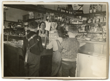
Photograph - Alice BAKER serves two local lads in shop, corner Farrell and Ross Streets, Port Melbourne, 1940 - 1959
... and Traders - Milkbars Alice BAKER Charles BAKER Ross Street Farrell ...Black and white photo. Inside the corner shop at Farrell and Ross Streets. Alice BAKER serves two local lads. Charles and Alice BAKER opened their shop around 1933 although a shop had been at this site since 1900 as variously a butcher and pastry cook and general store. The shop passed into other hands around 1955. The photo was used in the PMHPS Calendar for 2007 (May)business and traders - milkbars, alice baker, charles baker, ross street, farrell street -
Port Melbourne Historical & Preservation Society
Plan - Bridge over lagoon, Graham Street, Sandridge, Borough of Sandridge, 15 Oct 1878
... Melbourne Town Hall 333 Bay Street Port Melbourne melbourne ...Drawing of Graham Street bridge over the lagoon, 1878.Signed by E. Clark, Town Clerk, and Chas. Clay, Borough Surveyor.engineering - bridges, edward clark, town clerks, charles clay, graham street, sandridge lagoon -
 City of Ballarat Libraries
Photograph - Card Box Photographs, 213 Victoria Street, Ballarat East circa 1903
... in front of their home. Victoria Street Charles Ludbrook Building ...Charles Ludbrook and son stand out in front of their home.victoria street, charles ludbrook, building, private dwelling, persons -
 City of Ballarat Libraries
Photograph - Card Box Photographs, The Ludbrook Family circa 1918
... at 213 Victoria Street, Ballarat East. Victoria Street Charles ...The family are pictured at their home at 213 Victoria Street, Ballarat East.victoria street, charles ludbrook, building, private dwelling, persons -
Port Melbourne Historical & Preservation Society
Photograph - CD-ROM, various Port Melbourne images, Charles Nettleton, 1875 - 1911
... Beach Street Stokes Street Charles Nettleton Carlton Ale Fosters ...Gives us a visual description of Bay Street and other highlights in the late 1800s to early 1900sCD of digitised images from late 1800s to early 1900s. Images are of Bay St, from the North East; the Freemasons Hotel; Corner Beach and Stokes Streetsnatural environment - beaches and foreshore, built environment - commercial, bay street, beach street, stokes street, charles nettleton, carlton ale, fosters lager beer, whittle, business and traders - hotels, freemason's tavern -
 Mission to Seafarers Victoria
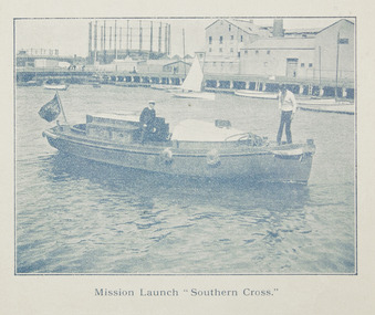
Photograph, Mission Launch Southern Cross, c. 1910
... street charles blunt blunt boatbuilders geelong Printed ...The motor boat built by Charles Blunt was donated in 1906, and was useful for ships' visit.Printed photograph published in the Annual Report for 1910 on page 35, depicting Reverend Alfred Gurney Goldsmith on board the mission's motor boat with another man. The image was taken on the Yarra River near the Docklands Gasworks.alfred gurney goldsmtih, motor boat, motor launch, southern cross, yarra river, gasworks, docklands, flinders street, charles blunt, blunt boatbuilders, geelong -
 Whitehorse Historical Society Inc.
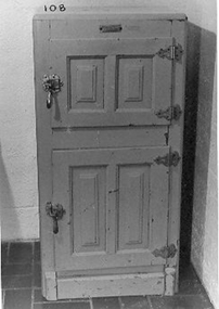
Functional object - Ice Chest, c1940s
... Charles Street, Nunawading in 1956... Charles Street, Nunawading in 1956 domestic items food storage ...Ice boxes became available when ice was cheaply manufactured. The ice was delivered daily or three times a week. Ice chest used at family home in Clifton Hill and then bought to 12 Charles Street, Nunawading in 1956Two door green chest - top section for ice, bottom section for food - lined with an insulation material which is covered with an enamelled metal. Provision made to drain water away.Pure Airdomestic items, food storage & preservation -
 Kew Historical Society Inc
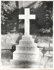
Photograph, Walsh grave, Boroondara General Cemetery, circa 1965, c. 1965
... James Venn Morgan on the corner of Charles Street and Cotham... Morgan on the corner of Charles Street and Cotham Road ...Dr William Butler Walsh was born in 1854. He bought from James Venn Morgan on the corner of Charles Street and Cotham Road and in 1886 built Wilton on this site. He was at one stage the only doctor between Melbourne and Lilydale.This work forms part of the collection assembled by the historian Dorothy Rogers, that was donated to the Kew Historical Society by her son John Rogers in 2015. The manuscripts, photographs, maps, and documents were sourced by her from both family and local collections or produced as references for her print publications. Many were directly used by Rogers in writing ‘Lovely Old Homes of Kew’ (1961) and 'A History of Kew' (1973), or the numerous articles on local history that she produced for suburban newspapers. Most of the photographs in the collection include detailed annotations in her hand. The Rogers Collection provides a comprehensive insight into the working habits of a historian in the 1960s and 1970s. Together it forms the largest privately-donated collection within the archives of the Kew Historical Society.Grave of the Walsh family in the Boroondara General Cemeterywilliam butler walsh, boroondara general cemetery, dorothy rogers, kew cemetery -
 Ringwood and District Historical Society
Flyer, Land Sale Advertisement - East Ringwood Township Estates, East Ringwood, Victoria - circa 1920
... Avenue, and Charles Street. (Agents) Spencer Jackson, Subdivider... Road, Holland Road, Purser Avenue, and Charles Street. (Agents ...The date of the flyer as circa 1920 can be estimated from the references to the (decision on) "electrification of the Croydon Railway Line" which eventually occurred in 1923, letting of tenders for the state school building which opened in 1924, and the "proposed new railway station" (East Ringwood) which opened in 1925, Advertisement for three retail and residential allotment land sales in East Ringwood Township including maps showing layout of subdivisions. Township Estate, State School Estate, and East Ringwood Station Estate.Subdivision plans include Mount Dandenong Road, Grey Street, Eastfield Road, King Street, Everard Road, Holland Road, Purser Avenue, and Charles Street. (Agents) Spencer Jackson, Subdivider & Homebuilder, 341 Collins Street, Melbourne, Phones: M2327 (3 lines), also at Dromana, Phone 65. -
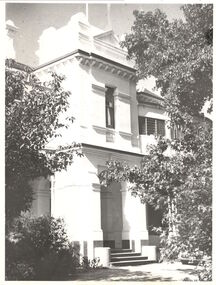
 Kew Historical Society Inc
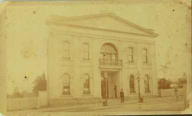
Photograph - Former Kew Town Hall, Walpole Street, 1887
... to a new building on the corner of Charles Street and Cotham Road.... on the corner of Charles Street and Cotham Road. This is the earliest ...The earliest building on the Walpole Street site was the Kew Athenaeum Hall (built 1860) which was purchased by Kew Council in 1865. The Town Hall was sold to Woolworth's and subsequently demolished in 1972 when the civic offices were transferred to a new building on the corner of Charles Street and Cotham Road.This is the earliest known image of the old Kew Town Hall following the addition of the new facade in the 1880s.A print copy of a gelatin silver photograph of the former Kew Town Hall in Walpole Street, Kew. The photograph shows the neo-classical facade added to the former Atheneum building in the 1880s. The recessed doors in the entrance are now held by Trinity Grammar School. A man, probably Cr Edmund Marshall, is standing outside the entrance. Two gas lamps stand in front of the Hall.Reverse in pencil: "Edmund Marshall Councillor 1887"town halls, kew town hall, walpole street - kew (vic.) -
 Wycheproof & District Historical Society Inc.
Photograph, St Andrew's Presbyterian Church Complex
... and the building of a church. The first church was in Charles Street... was in Charles Street on the north side of the Mount. It served ...The first Presbyterian gathering was held in Wycheproof in 1876, this led to the organization of a congregation and the building of a church. The first church was in Charles Street on the north side of the Mount. It served the congregation for twenty years. The new church in Mount Street opened 06-09-1896 and after 115 years the doors closed for worship in 2011.A building of spiritual and social significance to the Presbyterian congregation and wider community of Wycheproof and District for 115 years.Small format sepia print taken between 1912-1937of the Wycheproof Presbyterian Church Complex. Designed on early English lines, the church dated 1896 was built of red-brick with buttresses and decorated cream-brick trimmings. The arched windows are glazed in diamond shaped leadlight. The high pitched roof is of galvanized corrugated iron. The Sunday School Hall 1912, of timber construction with feature trim of arched windows and doors and a galvanized corrugated iron roof. The Manse 1909, of timber construction with galvanized corrugated iron roof and fret-work on the space above the verandah. Iron lace decorates the wooden verandah posts. Fencing: Post and Rail. Kodak print /501presbyterian, church, sunday school, manse, building, 1896, post and rail fence, red-brick, timber -
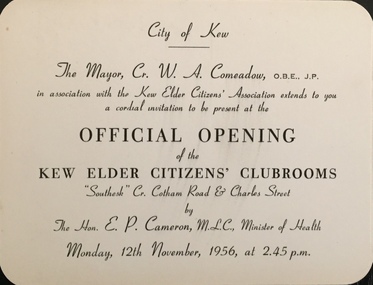 Kew Historical Society Inc
Document (item) - Invitation, City of Kew, Official Opening of the Kew Elder Citizens' Clubrooms, 1956
... AND CHARLES STREET / BY / THE HON E P CAMERON MLC, MINISTER OF HEALTH...' CLUBROOMS / 'SOUTHESK' CR, OF COTHAM ROAD AND CHARLES STREET ...The Municipality of Kew (1860-1863), the Borough of Kew (1863-1910), the Town of Kew (1910-1921) and the City of Kew (1921-1994) were local government instrumentalities in the State of Victoria. In 1994, the City of Kew was amalgamated, together with the former Cities of Camberwell and Hawthorn, into the new City of Boroondara (1994- ). Like other local government entities of the period, Kew was administered by town clerks. The two notable town clerks in Kew's history were H. H. (Henry Hirst) Harrison (1868-1955) and W. D. (William Dickie) Birrell (1899-1974). Harrison was appointed to the position in 1901 and retired in 1938 after 37 years. Birrell, appointed Acting Town Clerk in 1921, became Town Clerk in 1938, following Harrison's retirement. He continued in this role until his retirement in 1966.This card is part of an historically significant civic collection, containing hundreds of separate invitations, documents, greeting cards, programmes and tickets issued and/or collected by successive town clerks. Items in the collection illuminate the political, social and cultural history of the district. As a continuous record, ranging across most decades of the Twentieth Century, they reveal changing tastes in design, values and relationships in the history of local government in Victoria.CITY OF KEW / THE MAYOR, CR W A COMEADOW OBE JP / IN CONJUNCTION WITH THE KEW ELDER CITIZENS' ASSOCIATION EXTENDS TO YOU A CORDIAL / INVITATION TO BE PRESENT AT THE OPENING OF THE / KEW ELDER CITIZENS' CLUBROOMS / 'SOUTHESK' CR, OF COTHAM ROAD AND CHARLES STREET / BY / THE HON E P CAMERON MLC, MINISTER OF HEALTH / MONDAY, 12TH NOVEMBER, 1956, AT 2.45 P.M.civic invitations -- kew (vic), kew elder citizens' association, southesk -
 Kew Historical Society Inc
Photograph, Façade of ‘Southesk', Cotham Road, 1970
... was located on the corner of Cotham Road and Charles Street, Kew...). The house was located on the corner of Cotham Road and Charles ...Colour enlargement of a photograph (slide) of Southesk (formerly Ordsall) in Cotham Road, Kew (demolished 1970).Colour photograph of the front lawn and façade of ‘Southesk’ (formerly ‘Ordsall’, built for John Halfey in 1882). The house was located on the corner of Cotham Road and Charles Street, Kew. The Italianate mansion was built in the Renaissance villa style on a bluestone plinth. Two balustrades surrounded the parapet of the roof and ran between the groups of pillars on either side of the entrance porch. The verandah was tiled and wide and Corinthian columns supported its roof. When the house passed into the hands of the City of Kew in 1948, the landscaping and formal flower beds were removed and replaced by lawns.The house was demolished in 1970.david carnegie, john halfey, southesk - cotham road - kew (vic), ordsall - cotham road - kew (vic) -
![Architectural Moulding: Fragment of plaster and cement cornice from Southesk [Ordsall]](/media/collectors/550653872162f11fb04854aa/items/66b185bc235bc2950ebe8440/item-media/66b197c7235bc2950ec38cc7/item-fit-380x285.jpg) Kew Historical Society Inc
Kew Historical Society IncArchitectural Moulding, Fragment of plaster and cement cornice from Southesk [Ordsall], 1870-80
... on the corner of Charles Street and Cotham Road, Kew, when... of Charles Street and Cotham Road, Kew, when it was demolished ...'Ordsall', renamed 'Southesk' in the 20th century was built for John Halfey in or before 1865. The house was rebuilt in the 1870s to designs by architect Michael Hennessy. In 1882 the house was redecorated by the firm of Cullis Hill & Co., who hired the artists 'Mr Vandenbrandt' and 'Signor Rizzi" to paint the ceilings of the ballroom and the drawingroom. The artistic triumph was described in detail in The Argus, 30 October, 1882. In 1947, Southesk was purchased by the Kew City Council. For 23 years it was used as a meeting place for community groups. The house was then demolished in 1970 to make way for a new Town Hall.Rare, and possible unique fragment of a plaster cornice from one of the most architecturally distinctive houses in Kew, demolished 1970.Section of plaster cornice removed from Southesk on the corner of Charles Street and Cotham Road, Kew, when it was demolished in 1970 by the City of Kew. The cornice has a narrow layer of previously coloured plaster which is now overlaid with a grey distemper. The foundation of the cornice is moulded cement. Remnant flowers moulded in the central band of the cornice include a rose and a sunflower. The plaster decoration was probably located in the entrance hall, dining room or ballroom, all of which were created in the 1870s by Michael Hennessy and decorated by the firm of art decorators, Cullis Hill & Co in 1882.Nilordsall, south esk, cullis hill, plasterwork, cornices, victorian interiors -
 Kew Historical Society Inc
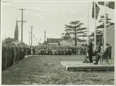
Photograph - Anzac Day Service in front of the Kew City Hall and World War II Memorial, 1960
... to Charles Street and the lawns of South Esk. The speaker would... to Charles Street and the lawns of South Esk. The speaker would ...The Kew City Hall, designed by the architect Harold Bartlett of Leith & Bartlett, was opened by The Premier The Hon HE Bolte on 23rd April 1960. At the time of the opening, Cr Ferguson was Mayor of Kew. Monochrome photograph of the annual Anzac Day service on the front lawn of the newly opened Kew City Hall in 1960. The Town Hall faced Cotham Road in front of which are standing returned soldiers. Invited seated and standing guests have their backs to Charles Street and the lawns of South Esk. The speaker would appear to be the Deputy Premier, and local Member for Kew Arthur Rylah MP. Behind the Official Party [but unseen] are the two Memorial plaques by George Henry Allen (1900–72). In the distance are the Kew Presbyterian Church and the Sacred Heart Church. Cr Ferguson / Anzac Day Service 1960kew city hall, city halls -- victoria, cr hugh ferguson, kew town hall, kew (vic.) -- civic buildings, anzac day services -- kew (vic.) -
 Kew Historical Society Inc
Photograph, 'Roberts House', Trinity Grammar School, c. 1965
... street, and Charles street, Kew, which adjoins the property... street, and Charles street, Kew, which adjoins the property ...The Argus in November 1924 reported the purchase of Elsinore by Trinity Grammar School. "The council of Trinity Grammar School, Kew, has purchased Elsinore, the residence of the late Mr. V. J. Saddler, at the corner of Wellington street, Stanley street, and Charles street, Kew, which adjoins the property recently purchased from Mr. J. Henning Thompson (known as 'Trinity Lodge), and is directly opposite the Headmaster's house and main school grounds.This work forms part of the collection assembled by the historian Dorothy Rogers, that was donated to the Kew Historical Society by her son John Rogers in 2015. The manuscripts, photographs, maps, and documents were sourced by her from both family and local collections or produced as references for her print publications. Many were directly used by Rogers in writing ‘Lovely Old Homes of Kew’ (1961) and 'A History of Kew' (1973), or the numerous articles on local history that she produced for suburban newspapers. Most of the photographs in the collection include detailed annotations in her hand. The Rogers Collection provides a comprehensive insight into the working habits of a historian in the 1960s and 1970s. Together it forms the largest privately-donated collection within the archives of the Kew Historical Society.The central tower of Roberts House (originally 'Elsinore'), Wellington Street, Kew. Part of Trinity Grammar School since 1924.4. Roberts House. Trinity Grammar School.roberts house, trinity grammar school, elsinore -
 Kew Historical Society Inc
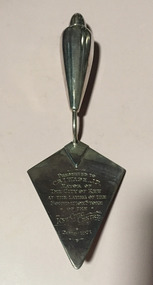
Ceremonial object, Unknown, Commemorative Trowel in Presentation Box, 1971, 1982
... Centre on the corner of Cotham Road and Charles Street, now part... Centre on the corner of Cotham Road and Charles Street, now part ...WADE, Ivan Mayor 1969-70, 1970-71 Ivan Wade grew up in Bendigo and Brunswick, one of eight children. After his marriage, he moved with his wife and young family to Kew in 1951. In 1959, he took a year’s sabbatical in 1959 to build a new family home for his wife and four children at 222 Cotham Road, Kew. He worked professionally in the Meat Industry, successfully building a small chain of retail butcher shops, and a meat exporting business. He worked for improvements in the Trade through involvement in the Meat and Allied Trades Federation, of which he was the first State, and then Federal President. He was to be awarded an OBE for his services to the Meat Industry in 1979. Having been a long-time member of Melbourne Lions Club, he helped start Chadstone Lions’ Club as an inaugural tenant of the Chadstone Shopping Centre in 1979. He was also a tireless worker for charity, making his home available for functions raising funds for local groups. His passion for the community led him to stand for Kew Council as a representative of College Ward. As a councillor, he was elected mayor for two terms. During his term of office, new Kew Municipal Offices were constructed in Cotham Road. An active worker for the Kew Elder Citizens Association, he was involved in the establishment of an Opportunity Shop in Walpole Street to raise funds for the development of a new Centre in High Street. The Opportunity Shop was used to train locally unemployed youth skills such as furniture repair. (GW)Silver presentation trowel associated with the opening of significant civic projects in the former City of Kew.Commemorative, inscribed silver-plated presentation trowel given by the City of Kew to the Mayor, Cr Ivan Wade, on the occasion of the laying of the foundation stone of the new Kew Civic Centre on the corner of Cotham Road and Charles Street, now part of Trinity Grammar School. The silver trowel was presented in a black leather case lined with blue velvet. The trowel was to be used a second time in 1982 when Cr Wade and his wife laid the foundation stone of Hamer Court. The trowel was later donated to Kew Historical Society Inc by Gwlad Wade, the wife of Cr Ivan Wade, on 20 August 2000. Front: "Presented to Cr Wade J.P. / Mayor of / the City of Kew / at the laying of the / foundation stone / of the / Kew Civic Centre /20-8-1971." Reverse: This trowel was also used / by / Cr Ivan Wade OBE JP & Mrs Gwlad Wade / at the laying / of the foundation stone / of / "Hamer Court" / Hostel for the Aged / 22nd August 1982"cr ivan wade, hamer court, commemorative trowels, kew civic offices, city of kew 1860-1993 -
Kew Historical Society Inc
Archive (series) - Subject File, ANDERSON, William Nicholls (1873-1927), 1958
... Offices in Charles Street, where it was on loan from the Society... in the Mayor’s Room at the Kew Civic Offices in Charles Street, where ...Various PartiesReference, Research, InformationKHS Imposed OrderWilliam Nicholls Anderson (1873-1927) was an Australian painter, one of whose works from the 1906 series River + Rail is in the Kew Historical Society’s art collection (donated 1984). The archive file contains correspondence, biographical information (written by his niece), and locations in Kew where he lived. Much of the correspondence between the Society and the City of Kew relates to the painting and its location in the Mayor’s Room at the Kew Civic Offices in Charles Street, where it was on loan from the Society. Lucy M (Jean) Hornby, the artist’s niece was a resident of 5 and 20 Queen Street, Kew. william nicholls anderson, artists - kew (vic)william nicholls anderson, artists - kew (vic)