Showing 1537 items
matching ed ?
-
 Eltham District Historical Society Inc
Photograph - Aerial Photograph, Landata, Eltham, Vic, Apr. 1963
Centred on present day Eltham Ridge, Bolton Street, Eltham bounded by Elsa Court to north, Main Road to south, Bible Street to east and Reichelt Avenue and Rattray Road to west. Historic Aerial Imagery Source: Landata.vic.gov.au Aerial Photo Details: Project No :486 Project : MELBOURNE (1963) PROJECT Run : 6 Frame : 124 Date : 04/1963 Film Type : B/W Camera : RC8 Flying Height : 5100 Scale : 9600 Film Number : 1805 GDA2020 : 37°43'12"S, 145°08'16"E MGA2020 : 335876, 5823604 (55) Melways : 21 G6 (ed. 42)aerial photo, neil webster collection, 1963-04, bible street, bolton street, eltham, eltham ridge, main road, montmorency, rattray road, reichelt avenue -
 Eltham District Historical Society Inc
Photograph - Aerial Photograph, Landata, Eltham, Vic, Apr. 1963
Centred on present day Griffith Park Road, Eltham bounded by Mount Pleasant Road to north, Yarra River and Templestowe to south, Main Road at Reynolds Road to east and Falkiner Street to west. Historic Aerial Imagery Source: Landata.vic.gov.au Aerial Photo Details: Project No :486 Project : MELBOURNE (1963) PROJECT Run : 7 Frame : 233 Date : 04/1963 Film Type : B/W Camera : RC8 Flying Height : 5100 Scale : 9600 Film Number : 1805 GDA2020 : 37°44'04"S, 145°09'10"E MGA2020 : 337237, 5822053 (55) Melways : 22 A10 (ed. 42)aerial photo, neil webster collection, 1963-04, eltham, falkiner street, griffith park road, melway 22a10, mount pleasant road, reynolds road, templestowe, yarra river -
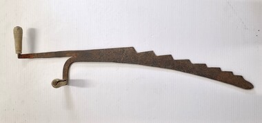 Wodonga & District Historical Society Inc
Tool - Hay Bale Saw, c1940s
Hay bale saws were a common agricultural tool. Ed Nolt, a Dutch resident of Pennsylvania, USA, invented the prototype for the small square baler back in the 1930s. His patent was purchased and mass produced during the 1940s. These balers quickly spread throughout the world and became a common agricultural machine. The hale bale saw was used to cut up the bales when distributing feed to livestock. As modern agricultural production has turned more to the use of large round bales, these small saws have become obsolete. This saw was used by a farmer in North Barnawatha approximately 18 kilometres from Wodonga, Victoria.This saw is representative of the agricultural tools in the mid to late 20th century.A metal saw with 2 wooden handles. The saw has a very coarse serrated edge. One of the handles is parallel to the blade, and the other handle is perpendicular to the blade.agricultural tools, hay bale saws, north east victoria -
 Eltham District Historical Society Inc
Photograph - Aerial Photograph, Landata, Eltham, Vic, Apr. 1972
Centred on present day Parsons Road, Eltham bounded by Allendale Road to north, Frank Street to south, Research Shops and Raglan Road to east and Zig Zag Road to west. Historic Aerial Imagery Source: Landata.vic.gov.au Aerial Photo Details: Project No :985 Project : MELBOURNE 1972 Run : 26 Frame : 192 Date : 04/1972 Film Type : B/W Camera : RC10 Flying Height : 5700 Scale : 9600 Film Number : 2636 GDA2020 : 37°42'00"S, 145°09'59"E MGA2020 : 338360, 5825897 (55) Melways : 22 D1 (ed. 42)aerial photo, neil webster collection, 1972-04, allendale road, eltham, zig zag road, frank street, melway 22d1, parsons road, raglan road, research (vic.), research shops, eltham barrel -
 Eltham District Historical Society Inc
Photograph - Aerial Photograph, Landata, Eltham, Vic, Apr. 1972
Centred on present day Zig Zag Road near Coolabah Drive, Eltham bounded by Allendale Road to north, Park West Road to south, Parsons Road to east and Banks Road to west. Historic Aerial Imagery Source: Landata.vic.gov.au Aerial Photo Details: Project No :985 Project : MELBOURNE 1972 Run : 26 Frame : 191 Date : 04/1972 Film Type : B/W Camera : RC10 Flying Height : 5700 Scale : 9600 Film Number : 2636 GDA2020 : 37°41'56"S, 145°09'26"E MGA2020 : 337533, 5826000 (55) Melways : 22 A1 (ed. 42)aerial photo, neil webster collection, 1972-04, allendale road, eltham, eltham north, zig zag road, banks road, coolabah drive, melway 22a1, park west road, parsons road -
 Eltham District Historical Society Inc
Photograph - Aerial Photograph, Landata, Eltham, Vic, Apr. 1972
Centred on present day Woodridge Estate, Eltham bounded by Park Road to north, Mount Pleasant Road to south, Stokes Orchard Estate to east and Eltham Railway Station to west. Historic Aerial Imagery Source: Landata.vic.gov.au Aerial Photo Details: Project No :985 Project : MELBOURNE 1972 Run : 27 Frame : 46 Date : 04/1972 Film Type : B/W Camera : RC10 Flying Height : 5700 Scale : 9600 Film Number : 2636 GDA2020 : 37°42'49"S, 145°09'46"E MGA2020 : 338053, 5824365 (55) Melways : 22 C5 (ed. 42)aerial photo, neil webster collection, 1972-04, eltham, eltham railway station, melway 22c5, mount pleasant road, park road, stokes orchard estate, woodridge estate -
 Eltham District Historical Society Inc
Photograph - Aerial Photograph, Landata, Eltham, Vic, Apr. 1972
Centred on present day Main Road at Pryor Street, Eltham bounded by Park West Road to north, Napoleon Street to south, Woodridge Estate to east and Ryans Road to west. Historic Aerial Imagery Source: Landata.vic.gov.au Aerial Photo Details: Project No :985 Project : MELBOURNE 1972 Run : 27 Frame : 47 Date : 04/1972 Film Type : B/W Camera : RC10 Flying Height : 5700 Scale : 9600 Film Number : 2636 GDA2020 : 37°42'45"S, 145°09'12"E MGA2020 : 337223, 5824470 (55) Melways : 22 A4 (ed. 42)aerial photo, neil webster collection, 1972-04, eltham, eltham railway station, woodridge estate, eltham shops, main road, melway 22a4, napoleon street, park west road, pryor street, ryans road -
 Eltham District Historical Society Inc
Photograph - Aerial Photograph, Landata, Eltham, Vic, Apr. 1972
Centred on present day Dalton Street at Mount Pleasant Road, Eltham bounded by Arthur Street to north, Yarra River and Kent Hughes Road to south, Eucalyptus Road to east and Susan Street to west. Historic Aerial Imagery Source: Landata.vic.gov.au Aerial Photo Details: Project No :985 Project : MELBOURNE 1972 Run : 28 Frame : 208 Date : 04/1972 Film Type : B/W Camera : RC10 Flying Height : 5700 Scale : 9600 Film Number : 2635 GDA2020 : 37°43'29"S, 145°08'54"E MGA2020 : 336816, 5823118 (55) Melways : 21 J8 (ed. 42)aerial photo, neil webster collection, 1972-04, eltham, arthur street, dalton street, eucalyptus road, kent hughes road, melway 21j8, mount pleasant road, susan street, yarra river -
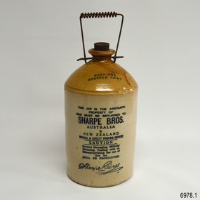 Flagstaff Hill Maritime Museum and Village
Container - Stoneware Demijohn, Bendigo Pottery , 1904-1930s
This Sharpe Bros. one gallon stoneware Demijohn is in excellent condition and includes its original stopper. It was made between 1904 and 1930, the date from the patent of the handle until the time that the factory no long produced returnable items. The bottle was once part of Dr W.R. Angus' household and is part of the W.R. Angus Collection and could have been purchased from Warrnambool's Sharpe Bros. factory. SHARPE BROS. 1903-1972- The first Sharpe Bros. cordial factory was opened in Dunedin, New Zealand, in 1903 by English prohibition brothers John and Percy Sharpe. Sharpe Bros. made ‘health’ beverages that were non-alcoholic drinks such as ginger beer, ginger ale, lime juice, soda and cordials. The containers of these drinks were not sold with the drinks but were marked as returnable items, to be cleaned and re-used, until this practice ceased in the 1930s. Sharpe Bros. made a niche in the soft drink market by delivering drinks by horse and cart to its customers’ homes. John Sharpe patented the unique wire spiral handle in 1904. By 1905 the New Zealand company also had factories in Australia. By 1910 the company had over 20 factories including Wanganui, New Zealand; Adelaide, Albury, Ballarat, Bathurst, Forbes, Geelong, Goulburn, Lithgow, Melbourne, Newcastle, Orange, Sydney, Tamworth, Warrnambool and Wollongong. The Warrnambool factory was established in 1919 and existed until 1951. The company won awards at Australian exhibitions for its carbonated drinks, including First Prize for its ginger beer made in the Brisbane factory. The company was taken over in 1962 by Tarax Drinks Holdings Ltd, which was in turn taken over by Cadbury Schweppes in 1972. W.R. Angus Collection- The W R Angus Collection spans from 1885 to the mid-1900s and includes historical medical and surgical equipment and instruments from the doctors Edward and Thomas Ryan of Nhill, Victoria. Dr Angus married Gladys in 1927 at Ballarat, the nearest big city to Nhill where he began as a Medical Assistant. He was also Acting House surgeon at the Nhill hospital where their two daughters were born. He and his family moved to Warrnambool in 1939, where Dr Angus operated his own medical practice. He later added the part-time Port Medical Officer responsibility and was the last person appointed to that position. Dr Angus and his wife were very involved in the local community, including the early planning stages of the new Flagstaff Hill, where they contributed to the layout of the gardens. Dr Angus passed away in March 1970.This stoneware Demijohn is connected to the history of Warrnambool, as it was owned by the daughter of Dr W. R. Angus and his wife Gladys. It is part of the W.R. Angus Collection, which is notable for still being located at the site connected to Doctor Angus, Warrnambool’s last Port Medical Officer. It is also connected through its manufacturer Sharpe Bros. which had a branch in Warrnambool from 1919 to 1951, overlapping the time when the Angus family resided there from 1939 to the 1970s. The bottle is also significant as an example of the early-20th-century beverages found in local households and could have been purchased from the local Sharpe Bros. factory.This stoneware Demijohn is glazed, with a brown neck with internal thread and shoulders and a cylindrical cream base. The one gallon bottle has a flat, black stopper with a cork stem and a rubber, threaded tip. The ‘U’ shaped wire carry handle has a spiral of wire around the handpiece. An overhanging lip is on top of the bottle’s short neck above its rounded shoulder. The clay has been joined at the base of the neck, shoulder and body. The underneath is unglazed. The brown glazing on the shoulder has a run mark. Inscriptions are on the stopper and bottle. This container is part of the W.R. Angus Collection.Stamped in black on the shoulder: “KEEP THE / STOPPER TIGHT” Stamped in black on the body: “THIS JAR IS THE ABSOLUTE PROPERTY OF AND MUST BE RETURNED TO SHARPE BROS. AUSTRALIA / & NEW ZEALAND. ORIGINAL & LARGEST HYGIENIC BREWERY. CAUTION Persons Damaging, Willfully Retaining, Trading with or Misappropriating the Use of this Jar WILL BE PROSECUTED “ Stamped in script writing: “Sharpe Bros. TRADE - - - ED “ Embossed on the stopper: “AUSTRALIA AND NEW ZEALAND, SHARPE BROS.”flagstaff hill, warrnambool, maritime village, maritime museum, shipwreck coast, great ocean road, dr w r angus, dr roy angus, dr ryan, sharpe bros., bendigo pottery, bottle, stoneware bottle, demihohn, one gallone bottle, soft drink, non-alcoholic drink, drink container, jar, jug, warrnambool soft drink, hygienic brewery, cordial factory, new zealand, australia, john sharpe, percy sharpe, non-alcoholic, spiral wire handle, ginger beer, w.r. angus collection, demijohn -
 Eltham District Historical Society Inc
Photograph - Aerial Photograph, Landata, Eltham, Vic, Jan. 1951
Centred on Allison Crecent Reserve, Sherbrook Road and Scenic Crescent, Eltham bounded by Allendale Road to north, Dudley Street to south, Zig Zag Road to east and St Helena Road to west. Historic Aerial Imagery Source: Landata.vic.gov.au Aerial Photo Details: Project No :65 Project : MELBOURNE AND METROPOLITAN PROJECT NO. 2 Run : 7 Frame : 10 Date : 01/1951 Film Type : B/W Camera : EAG9 Flying Height : 12200 Scale : 12000 Film Number : 1419 GDA2020 : 37°42'14"S, 145°08'36"E MGA2020 : 336339, 5825416 (55) Melways : 21 H2 (ed. 42)Historical aerial photos and photo maps provide viusal evidence of the chronology of changes to the built landscape of the district and assist in dating other imagesaerial photo, 1951-01, eltham, neil webster collection, allendale road, allison crecent reserve, dudley street, melway 21h2, scenic crescent, sherbrook road, st helena road, zig zag road -
 Eltham District Historical Society Inc
Photograph - Aerial Photograph, Landata, Eltham, Main Road; Mt Pleasant Rd to Railway Rd, Dec. 1945
Centred on Main Rd and Henry St, Eltham bounded by Railway Road to north, Mount Pleasant Road at Main Road to south, top of the hill in Arthur Street to east and Karingal Drive at Sherbourne Road to west. Historic Aerial Imagery Source: Landata.vic.gov.au Aerial Photo Details: Project No :65 Project : MELBOURNE AND METROPOLITAN PROJECT NO. 2 Run : 8 Frame : 70 Date : 01/1951 Film Type : B/W Camera : EAG9 Flying Height : 12200 Scale : 12000 Film Number : 1419 GDA2020 : 37°43'06"S, 145°08'45"E MGA2020 : 336589, 5823811 (55) Melways : 21 J6 (ed. 42)aerial photo, eltham, main road, henry street, arthur street, bolton street, eltham-yarra glen road, neil webster collection, 1951-01, dave lyon house, ernie andrew house, karingal road, melway 21j6, mount pleasant road, railway road -
 Eltham District Historical Society Inc
Photograph - Aerial Photograph, Landata, Montmorency, Feb. 1956
Centred on present day Grand Boulevard and Olympic Way, Montmorency bounded by Diamond Street to north, Old Eltham Road and Eltham Lower Park to south, Bible Street to east and Para Road to west. Historic Aerial Imagery Source: Landata.vic.gov.au Aerial Photo Details: Project No :250 Project : MELBOURNE OUTER SUBURBS PROJECT Run : 17 Frame : 115 Date : 02/1956 Film Type : B/W Camera : EAG9 Flying Height : 10000 Scale : 12000 Film Number : 1176 GDA2020 : 37°43'24"S, 145°07'55"E MGA2020 : 335375, 5823236 (55) Melways : 21 F7 (ed. 42)aerial photo, 1956-02, neil webster collection, eltham, main road, montmorency, bible street, diamond street, eltham lower park, grand boulevard, melway 21f7, old eltham road, olympic way, para road -
 Eltham District Historical Society Inc
Photograph - Aerial Photograph, Landata, Eltham, Vic, Apr. 1963
Centred on present day Zig Zag Road and Main Road, Eltham bounded by Maroondah Aqueduct to north, Thompson Crescent and Arthur Street to south, Parsons Road to east and Glen Park Road and Banks Road to west. Historic Aerial Imagery Source: Landata.vic.gov.au Aerial Photo Details: Project No :486 Project : MELBOURNE (1963) PROJECT Run : 5 Frame : 59 Date : 04/1963 Film Type : B/W Camera : RC8 Flying Height : 5100 Scale : 9600 Film Number : 1805 GDA2020 : 37°42'24"S, 145°08'52"E MGA2020 : 336716, 5825114 (55) Melways : 21 J3 (ed. 42)aerial photo, neil webster collection, eltham, 1963-04, arthur street, banks road, glen park road, maroondah aqueduct, melway 21j3, parsons road -
 Eltham District Historical Society Inc
Photograph - Aerial Photograph, Landata, Eltham, Feb. 1956
Centred on present day Mount Plaeasant Road near Dalton Street, Eltham bounded by Luck Street to north, Eltham Lower Park to south, Reynolds Road to east and Central Park to west Historic Aerial Imagery Source: Landata.vic.gov.au Aerial Photo Details: Project No :250 Project : MELBOURNE OUTER SUBURBS PROJECT Run : 18 Frame : 93 Date : 02/1956 Film Type : B/W Camera : EAG9 Flying Height : 10000 Scale : 12000 Film Number : 1176 GDA2020 : 37°43'02"S, 145°09'38"E MGA2020 : 337871, 5823961 (55) Melways : 22 B6 (ed. 42)aerial photo, 1956-02, neil webster collection, eltham, central park, eltham lower park, luck street, melway 22b6, nyora road, reynolds road, dalton street, mount pleasant road -
 Eltham District Historical Society Inc
Photograph - Aerial Photograph, Landata, Eltham, Vic, Feb. 1956
Centred on present day Parsons Avenue at Leane Drive near the Maroondah Aqueduct, Eltham bounded by Lorimer Road to north, Thompson Crescent and Norman Road to south, Bells Hill Road to east and Parsons Road to west Historic Aerial Imagery Source: Landata.vic.gov.au Aerial Photo Details: Project No :250 Project : MELBOURNE OUTER SUBURBS PROJECT Run : 19 Frame : 5 Date : 02/1956 Film Type : B/W Camera : EAG9 Flying Height : 10000 Scale : 12000 Film Number : 1176 GDA2020 : 37°42'04"S, 145°11'09"E MGA2020 : 340064, 5825786 (55) Melways : 22 H1 (ed. 42)aerial photo, 1956-02, neil webster collection, allendale road, bells hill road, eltham, leane drive, lorimer road, maroondah aqueduct, melway 22h1, norman road, parsons road, research (vic.), thompson crescent -
 Eltham District Historical Society Inc
Photograph - Aerial Photograph, Landata, Eltham, Vic, Apr. 1963
Centred on present day Floriston Grove, Eltham bounded by Maroondah Aqueduct to north, Thompson Crescent and Diosma Road to south, Research Shops to east and Glen Park Road and Park West Road to west. Historic Aerial Imagery Source: Landata.vic.gov.au Aerial Photo Details: Project No :486 Project : MELBOURNE (1963) PROJECT Run : 5 Frame : 60 Date : 04/1963 Film Type : B/W Camera : RC8 Flying Height : 5100 Scale : 9600 Film Number : 1805 GDA2020 : 37°42'24"S, 145°09'29"E MGA2020 : 337622, 5825128 (55) Melways : 22 B3 (ed. 42)aerial photo, neil webster collection, eltham, 1963-04, diosma road, floriston grove, maroondah aqueduct, melway 22b3, park west road, research (vic.), research shops -
 Eltham District Historical Society Inc
Photograph - Aerial Photograph, Landata, Lower Plenty, Vic, Apr. 1963
Centred on present day Old Eltham Road near Araluen Centre, Lower Plenty bounded by Cromwell Street to north, Yarra River to south, Main Road at Mount Pleasant Road to east and Panorama Avenue to west. Historic Aerial Imagery Source: Landata.vic.gov.au Aerial Photo Details: Project No :486 Project : MELBOURNE (1963) PROJECT Run : 7 Frame : 231 Date : 04/1963 Film Type : B/W Camera : RC8 Flying Height : 5100 Scale : 9600 Film Number : 1805 GDA2020 : 37°44'03"S, 145°07'56"E MGA2020 : 335420, 5822027 (55) Melways : 21 F10 (ed. 42)aerial photo, neil webster collection, 1963-04, araluen, cromwell street, eltham, lower plenty, main road, melway 21f10, mount pleasant road, old eltham road, panorama avenue, yarra river -
 Eltham District Historical Society Inc
Photograph - Aerial Photograph, Landata, Eltham, Vic, Apr. 1963
Centred on present day Eltham Lower Park bounded by Brougham Street to north, Yarra River and Fitzsimons Lane Bridge to south, Main Road at Kent Hughes Road to east and Bolton Street to west. Historic Aerial Imagery Source: Landata.vic.gov.au Aerial Photo Details: Project No :486 Project : MELBOURNE (1963) PROJECT Run : 7 Frame : 232 Date : 04/1963 Film Type : B/W Camera : RC8 Flying Height : 5100 Scale : 9600 Film Number : 1805 GDA2020 : 37°44'03"S, 145°08'33"E MGA2020 : 336329, 5822040 (55) Melways : 21 H10 (ed. 42)aerial photo, neil webster collection, 1963-04, bolton steet, brougham steet, eltham, eltham lower park, fitzsimons lane bridge, kent hughes road, melway 21h10, yarra river -
 Eltham District Historical Society Inc
Photograph - Aerial Photograph, Landata, Eltham North, Vic, Apr. 1972
Centred on present day Eltham North reserve near Eltham North Primary School, Eltham North bounded by Allendale Road to north, Bellevue Road to south, Zig Zag Road and Beard Street to east and Ryans Road to west. Historic Aerial Imagery Source: Landata.vic.gov.au Aerial Photo Details: Project No :985 Project : MELBOURNE 1972 Run : 26 Frame : 190 Date : 04/1972 Film Type : B/W Camera : RC10 Flying Height : 5700 Scale : 9600 Film Number : 2636 GDA2020 : 37°41'52"S, 145°08'52"E MGA2020 : 336705, 5826102 (55) Melways : 11 J12 (ed. 42)aerial photo, neil webster collection, 1972-04, allendale road, beard street, bellevue road, eltham, eltham north, eltham north reserve, melway 11j12, ryans road, zig zag road, eltham north primary school -
 Eltham District Historical Society Inc
Photograph - Aerial Photograph, Landata, Research, Vic, Apr. 1972
Centred on present day Main Road, Research near Maroondah Aqueduct and Eltham College bounded by Allendale Road to north, Research-Warrandyte Road to south, Swipers Gully Training Restaurant to east and Reynolds Road to west. Historic Aerial Imagery Source: Landata.vic.gov.au Aerial Photo Details: Project No :985 Project : MELBOURNE 1972 Run : 26 Frame : 194 Date : 04/1972 Film Type : B/W Camera : RC10 Flying Height : 5700 Scale : 9600 Film Number : 2636 GDA2020 : 37°42'07"S, 145°11'07"E MGA2020 : 340015, 5825692 (55) Melways : 22 H1 (ed. 42)aerial photo, neil webster collection, 1972-04, allendale road, eltham college, main road, maroondah aqueduct, melway 22h1, research (vic.), research-warrandyte road, reynolds road, swiper's gully -
 Eltham District Historical Society Inc
Photograph - Aerial Photograph, Landata, Eltham, Vic, Apr. 1972
Centred on present day Diamond Creek Trail at the Eltham Leisure Centre bounded by Central Park to north, Main Road at Falkiner Street to south, MacMahon Ball Paddock to east and Grand Boulevard at Buena Vista Drive to west. Historic Aerial Imagery Source: Landata.vic.gov.au Aerial Photo Details: Project No :985 Project : MELBOURNE 1972 Run : 28 Frame : 207 Date : 04/1972 Film Type : B/W Camera : RC10 Flying Height : 5700 Scale : 9600 Film Number : 2635 GDA2020 : 37°43'25"S, 145°08'20"E MGA2020 : 335985, 5823223 (55) Melways : 21 G7 (ed. 42)aerial photo, neil webster collection, 1972-04, eltham, buena vista drive, central park, diamond creek trail, eltham leisure centre, falkiner street, grand boulevard, macmahon ball paddock, main road, melway 21g7 -
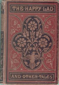 Bendigo Historical Society Inc.
Book - CONSTABLE JOHN BARRY COLLECTION: THE HAPPY LAD AND OTHER STORIES
Hard cover book, brown and black ornately decorated cover. Written on cover 'The Happy Lad And Other Tales'. Fixed to the inside front cover, is a prize certificate from the School of Mines and Industries, Bendigo, on which is written: Session 188, Mechanical Drawing Junior Division, Fourth Prize awarded to Thomas Barry. Signed A. Bayne President, A. Brough Smyth, Director. W.H. Ed Nicolai, Instructor. Thomas was a student at the Bendigo School of Mines. In May 1885, Thomas was awarded fourth prize for Mechanical Drawing, Junior Division. An article in the Bendigo Advertiser of 14th May,1885, page 4, lists Thomas Barry as a recipient of the 4th prize in the Mechanical Drawing, Junior Division.person, bendigo, thomas barry -
 Melbourne Legacy
Film, The Legacy Story
16 mm Black and white film with sound produced by Southern Cross Films, Perth. It begins with archival film from WWII, explains the meaning and symbolism of the Legacy badge,and shows young girls taking the Legacy oath. There were 1900 orphans in W. Australia and the film explains the origins of Legacy. Perth Legacy's Board of Management is shown and care of children - health and fitness - is explained. Also shown are the January seaside camp activities, annual Christmas picnic with 1000 guests, and a Legatee visiting one of his families with helpful advice. Craig House, Perth Legacy's co-ed residence is featured, followed by the annual presentation of debutantes. 10 mins 41 sec.A visual record of life in the 1950s and the huge number of children to have lost their father in WWII. The commitment of Legacy to giving them a better childhood and the amount of work done by Legatees is impressive.Blue metal canister and film on a spool labelled as The Legacy Story. The 16mm film runs for 10 mins 41 secs.Canister lid exterior, Label, HERSCHELLES FILM LABORATORIES, East Melbourne, Australia SUBJECT, “THE LEGACY STORY’, copy, length 404’ reel no. Canister base exterior, Label from Legacy Club Melbourne. 45 Market St, Melbourne, C.1. Typed label say '16mm Sound film of Perth Legacy's Activities. Purchased by Melbourne Legacy with Perth Legacy's permission and with authority of L/tee Morrie Tonkin and Board of Management of Melbourne Legacy. June 1965. I.E.L.'legacy promotion, activities, junior legatee, marketing -
 Eltham District Historical Society Inc
Photograph - Aerial Photograph, Landata, Eltham, Feb. 1956
Centred on present day Culla Hill and Petty's Orchard, Eltham bounded by Brougham Street and Mount Pleasant Road to north, Monckton Road, Templestowe to south, Reynolds Road to east and Eltham Lower Park and Hohnes Road to west. Historic Aerial Imagery Source: Landata.vic.gov.au Aerial Photo Details: Project No :250 Project : MELBOURNE OUTER SUBURBS PROJECT Run : 18 Frame : 92 Date : 02/1956 Film Type : B/W Camera : EAG9 Flying Height : 10000 Scale : 12000 Film Number : 1176 GDA2020 : 37°43'35"S, 145°09'31"E MGA2020 : 337735, 5822959 (55) Melways : 22 B8 (ed. 42)aerial photo, 1956-02, neil webster collection, eltham, brougham steet, culla hill, eltham lower park, hohnes road, melway 22b8, monckton road, mount pleasant road, petty's orchard, reynolds road, sweeneys lane, templestowe, yarra river -
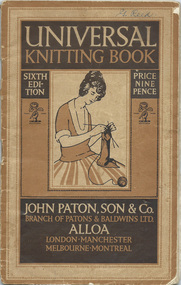 City of Moorabbin Historical Society (Operating the Box Cottage Museum)
Booklet - 'Universal Knitting Book' Paton, John Paton, Son & Co. 6th Edition 1923, c1923
Gladys Reed was a member of the Ormond Choral Society c 1950. who performed plays and musicals the City of Moorabbin and she was skilled in hand knitting, crochet and dressmaking. Her garments were used by her family and the Ormond Choral Society . Patons' & Baldwin Ltd began as two separate companies: J & J Baldwin and Partners, founded in the late 1770s by James Baldwin of Halifax, West Yorkshire, England, and John Paton Son & Co., founded in 1814 by John Paton of Alloa, Scotland. Both men had formed their businesses using the spinning mule developed by Samuel Crompton. They mainly produced yarns for commercial knitting machines. The two companies merged in 1920 and diversified into producing wool for home knitters, as well as publishing knitting patterns under the "Patons Rose" and "Baldwins Beehive" trademark. By the mid-1930s, the company had establishments across Scotland and Northern England, Canada, New Zealand, Launceston, Tasmania, Australia. The company branched out into various related lines of business, and the development of new products such as nylon and Terylene. In 1961, the company was merged with J & P Coats Ltd. The Patons trademark is still in use today.The yarn production facility at Alloa was closed in 1999 and the large factory in Launceston, Tasmania, Australia,closed in 1997. In 1952 J. & P. Coats and the Clark Thread Co. merged.and in 1961 a merger with Patons and Baldwins created Coats Patons. In 2015 the business returned to the market as "Coats Group".Patons' knitting books have been used by hand knitters in many countries since they were published early in 20thC Gladys Reed and other residents of the City of Moorabbin used these pattern guides to make clothing for their families and community c1950A printed paper booklet with 64 pages of knitting and crochet patterns, instructions, photographs bound by 2 metal staplesFront Cover ; UNIVERSAL/ KNITTING BOOK / SIXTH / ED / ITION / PRICE / NINE / PENCE / Photo of lady knitting / Trade Mark / JOHN PATON, SON & CO. / BRANCH OF PATONS & BALDWINS LTD. / ALLOA / LONDON, MANCHESTER / MELBOURNE / MONTREAL Written top right ; G Reed Back Cover ; Trade Mark / Registered / THIS TRADE MARK / IS YOUR GUARANTEE / WHEN BUYING / PATONS' ALLOA / KNITTING WOOLS knitting, crochet, craftwork, john paton son & co., baldwin j &j ltd, aloa scotland, launceston tasmania, melbourne, knitting mills, knitting books, coates j&p ltd, early settlers, moorabbin shire, mechanics institute cheltenham, ormond choral society, postworld war 11 settlers, housing estates moorabbin 1950, bentleigh, ormond, moorabbin, cheltenham, drama societies, musical society cheltenham, clark judy, reed gladys, reed george -
 Federation University Historical Collection
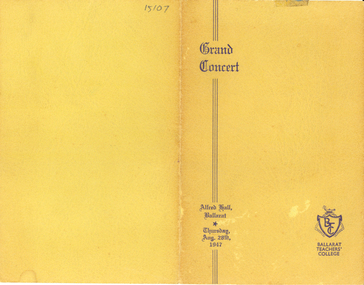
Programme, Ballarat Teachers' College, Ballarat Teachers' College Grand Concert, 1947
Ellwood was the Principal of the Ballarat Teachers' College. Ballarat Teachers’ College was opened on 04 May 1926, at S.S. 33 Dana Street, with an enrolment of 61 students. Its original staff consisted of the Principal, Mr W.H. Ellwood, M.A., M.Ed. (Chairman of the Teachers’ Tribunal from its inception in 1946 until 1954), Miss A. Bouchier, B.A., and Mr A.B. Jones, BA., (lecturers). In 1927 Miss P.A. Hamano joined the staff. In 1927 the college moved to the old Ballarat East Town Hall (remodelled for their use) in Barkly Street. During 1927 the numbers in the College were augmented by 26 Manual Arts students, who had formerly received their training at Ballarat High School. Manual Art students continued till 1930 when, on grounds of economy, their training was concentrated at Melbourne Teachers’ College. During the four succeeding years, approximately 60 students annually entered the primary course. Inclusive of Manual Arts students, and private fee-paying students, exactly 400 trainees passed through the College in its brief span of life (1926-1931). Five per cent of each year’s students were granted an extension of their studentship to enable them to proceed to Melbourne Teachers’ College, and to take the first year’s course for a University degree. With the advent of the economic depression of the ‘thirties, Ballarat Teachers' College closed its doors in December, 1931. Fourteen years were to pass before the College opened again on February 2nd, 1946. The college re-commenced at SS Dana Street, under the guidance of Mr W.F. Lord, M.C., M.M., B.A., Dip. Ed., (acting, later Principal 1946-1950) and a staff consisting of Miss E.B. Hughes, B.A., Dip. Ed., Mr C.B. Bryan, B.A., B. Com., Dip. Ed., Miss Monica H. Miller, L.Mus.A., and Miss G. Kentish, Dip. Phys. Ed. The opening ceremony was performed by the Minister of Education at that time, the Hon. F. Field, M.L.A., accompanied by the Hon. T.T. Hollway, M.L.A., and the then Director of Education, Mr J.A. Seitz. It was originally intended to cater for women students only but, at the last moment, men resident in Ballarat were also accepted. A co-educational college was thus set up instead, and it has continued as such. 1951 saw the introduction of the two-year course, successful students being presented with the Trained Primary Teacher’s Certificate at the final College Assembly each year. In December 1955, College held its first Graduation Ceremony, with its own Graduation Hymn, the words of which were written by Miss C.M. (Mavis) Canty of the staff. Lord remained as principal until 1951 when he transferred to establish a teachers' college at Toorak. Tom William Turner was Lord's successor. A highlight of his term was the construction of new college buildings at Gillies Street with the students commencing their lessons there in February 1958. Turner retired in 1970, having overseen a period of substantial growth in the institution. In that year alone more than one hundred and forty students completed their primary teaching qualification to meet a severe shortage of teachers. Doug Watson commenced as principal in 1971. In 1973 Ballarat Teachers' College became the State College of Victoria at Ballarat. Three years later Ballarat College of Advanced Education was formed and the teacher education students moved to the Mount Helen Campus. In 1990 Ballarat College of Advanced Education became Ballarat University College, an affiliated college with the University of Melbourne. The University of Ballarat was formed in January 1994.Yellow folded card programme for the Ballarat Teachers' College Grand Concert held at Alfred Hall Ballarat on Thursday 28 August 1947. Student Teachers from the 1947 class performed, including Jessie Batson, Ruth Tozer, Joy Love, N. Kerr, Arthur Lelean, D. Cooper, John Collins, Ann McKinnnon, Peg Purdue, Lindsay Harley.ballarat teachers' college, education, alfred hall -
 Federation University Historical Collection
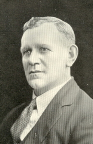
Programme, Ballarat Teachers' College Reunion Programme, 1934
Ellwood was the Principal of the Ballarat Teachers' College. Ballarat Teachers’ College was opened on 04 May 1926, at S.S. 33 Dana Street, with an enrolment of 61 students. Its original staff consisted of the Principal, Mr W.H. Ellwood, M.A., M.Ed. (Chairman of the Teachers’ Tribunal from its inception in 1946 until 1954), Miss A. Bouchier, B.A., and Mr A.B. Jones, BA., (lecturers). In 1927 Miss P.A. Hamano joined the staff. In 1927 the college moved to the old Ballarat East Town Hall (remodelled for their use) in Barkly Street. During 1927 the numbers in the College were augmented by 26 Manual Arts students, who had formerly received their training at Ballarat High School. Manual Art students continued till 1930 when, on grounds of economy, their training was concentrated at Melbourne Teachers’ College. During the four succeeding years, approximately 60 students annually entered the primary course. Inclusive of Manual Arts students, and private fee-paying students, exactly 400 trainees passed through the College in its brief span of life (1926-1931). Five per cent of each year’s students were granted an extension of their studentship to enable them to proceed to Melbourne Teachers’ College, and to take the first year’s course for a University degree. With the advent of the economic depression of the ‘thirties, Ballarat Teachers' College closed its doors in December, 1931. Fourteen years were to pass before the College opened again on February 2nd, 1946. The college re-commenced at SS Dana Street, under the guidance of Mr W.F. Lord, M.C., M.M., B.A., Dip. Ed., (acting, later Principal 1946-1950) and a staff consisting of Miss E.B. Hughes, B.A., Dip. Ed., Mr C.B. Bryan, B.A., B. Com., Dip. Ed., Miss Monica H. Miller, L.Mus.A., and Miss G. Kentish, Dip. Phys. Ed. The opening ceremony was performed by the Minister of Education at that time, the Hon. F. Field, M.L.A., accompanied by the Hon. T.T. Hollway, M.L.A., and the then Director of Education, Mr J.A. Seitz. It was originally intended to cater for women students only but, at the last moment, men resident in Ballarat were also accepted. A co-educational college was thus set up instead, and it has continued as such. 1951 saw the introduction of the two-year course, successful students being presented with the Trained Primary Teacher’s Certificate at the final College Assembly each year. In December 1955, College held its first Graduation Ceremony, with its own Graduation Hymn, the words of which were written by Miss C.M. (Mavis) Canty of the staff. Lord remained as principal until 1951 when he transferred to establish a teachers' college at Toorak. Tom William Turner was Lord's successor. A highlight of his term was the construction of new college buildings at Gillies Street with the students commencing their lessons there in February 1958. Turner retired in 1970, having overseen a period of substantial growth in the institution. In that year alone more than one hundred and forty students completed their primary teaching qualification to meet a severe shortage of teachers. Doug Watson commenced as principal in 1971. In 1973 Ballarat Teachers' College became the State College of Victoria at Ballarat. Three years later Ballarat College of Advanced Education was formed and the teacher education students moved to the Mount Helen Campus. In 1990 Ballarat College of Advanced Education became Ballarat University College, an affiliated college with the University of Melbourne. The University of Ballarat was formed in January 1994. Programme for the 1934 Ballarat Teachers' College Reunion run by the Ballarat teachers' College ex- Students Association. Inside the programme is an image of W.H. Ellwood and copy of his 14 points. ballarat teachers' college, ellwood, reunion, w.h. elwood, elwood's fourteen points -
 Melton City Libraries
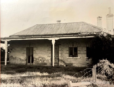
Photograph, Barrie Collection, The Willows, 1973
Currently the headquarters of the Melton Historical Society, the Willows was built in 1855 by a farmer called Ralph Parkinson. In 1867, it was purchased and extended by James Ebden Minns. His son, George Minns, was given the property by his father in 1903, George was a council member of Melton Shire for 37 years and after he eft the area in 1951, the property became derelict. Although due to the support of the community, Melton Shire Council purchased the property in 1972 and to assist with the restoration, a group was established called the Willows Restoration Committee. The members included Chairman Cr Ed Gillespie, Lorraine Gillespie, Mr & Mrs Alan Reed, Ken Young, Bill Amor, Edna Barrie, Max Watson, Cr Jeff Robinson and Wendy Barrie.Restoration was completed in 1982.The Willows before restoration in 1973. This is the view of the front of the house and part of side wire fencing.council, local special interest groups, pioneer families, local architecture, local identities -
 Melbourne Legacy
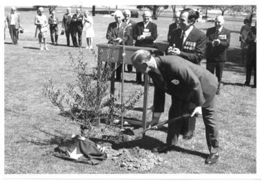
Photograph, Planting Olive Tree at Shrine 1973, 1973
A photo of the planting of the Olive Tree of Peace in the Western Lawn of the Shrine of Remembrance in 1973. Pencil inscription on reverse says "Frank Doolan planting the commemorative olive tree for Legacy. Beside him is Geoff Handbury, Melb President and Sir Ed Herring, (?), Kem (Kemsley), Col Rex Hall, George Cowan. (2 copies) Also a photo of Frank Doolan standing by the tree he has just planted. Legatee Frank Doolan was a long serving member of Legacy and given the honour of planting the tree. The plaque reads "1923 1973 / This olive tree symbolising peace marks fifty years of Legacy service to the widows of ex-servicemen and their children." 1973 was the Golden Jubilee year of Legacy (see also item 00441).A record of events to commemorate the golden jubilee of Legacy.Black and white photo x 3 of a tree planting at the Shrine of Remembrance.00442.1 Pencil inscription, some illegible 00442.2 Stamped "This Photograph is the compliments of the Ministry of Tourism, Government of Victoria. Please acknowledge / Photo: Michael Cheshire" in black ink.golden jubilee, tree planting, frank doolan, 50th anniversary -
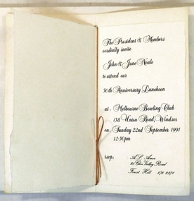 8th/13th Victorian Mounted Rifles Regimental Collection
Invitation, 1991
The 2/8th Armoured Regiment was raised in June 1941 under the command of Lieutenant Colonel W G Hopkins with officers and men selected from the wider AIF in Victoria. The regiment trained in newly arrived M3 General Grant tanks at Puckapunyal before moving north to Singleton, then the Wee Waa plains. The regiment sailed for New Guinea in April 1943 and carried out mobile defence to airfields at Port Moresby, Milne Bay, Dobadura and Popondetta. The regiment returned to Australia in February 1944 and disbanded as an armoured regiment and retrained as Nos 41, 42 and 43 Landing Craft Companies. They returned to the South West pacific serving at Bougainville, Balikpapan, Lae and Wewak. Lieutenant Colonel John Neale ED was a former Commanding Officer of 8th/13th Victorian Mounted Rifles.Representative of a luncheon to commemorate the formation of a World War II armoured regiment.Coloured folder with heading 2/8th Armoured Regiment Association colour patch and blue and yellow bands across top right hand corner.Secured inside by gold cord is invitation to 50th Anniversary Luncheon to John and June Neale, 22nd September 1991. 50th Anniversary Lapel pin is attached to front cover.2/8th armoured regiment, neale john