Showing 2261 items matching "murray road"
-
 Wodonga & District Historical Society Inc
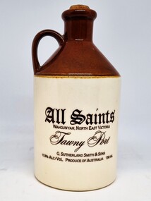
Functional object - Earthenware Bottle - All Saints Estate early 1980s
... Migrant Experience, 132 Bonegilla Road Bonegilla the-murray All ...All Saints Estate is a family-owned winery established in 1864 and located on the banks of the Murray River in Wahgunyah, Northeast Victoria. Original owners George Sutherland Smith, and John Banks, arrived from Caithness, Scotland in 1852. After being involved in a range of enterprises, they established the vineyard, including a castle based on the design of The Castle of Mey in Scotland, which was built in 1864. In 1873 in London, Sutherland Smith became the first Australian winemaker to win an award at an overseas wine show. Banks died in 1876 and All Saints remained in the hands of G. Sutherland Smith and his family, until after some variable fortunes in the late 1980s, it fell into the hands of a syndicate in 1989. After being passed in at a receiver’s auction in 1991, All Saints was acquired by Brown Brothers of Milawa in 1992. It is now owned and operated by the children of Peter R. Brown. During the early 1980s, All Saints took bulk orders for different corporations such as Ansett Air Freight, packaging them in jugs as this for special occasions or functions.This jug is representative of an historic and continuing leading Australian Winemaker located in Northeast Victoria.A pottery wine jug of tradition colours featuring a lower half of natural earthenware colour and a brown glazed top section. It has a loop handle and a cork closure. Originally it also had a wax seal closure. Company information and logos are featured on each side.On side 1: "All Saints / WAHGUNYAH, NORTH EAST VICTORIA/ Tawny Port / G. SUTHERLAND SMITH & SONS / 17.5% ALC/VOL. PRODUCE OF AUSTRALIA 750 ML" On reverse side: Below an image of an Ansett Airfreight Aeroplane: "We offer to you our warmest, / best wishes for the Christmas Season/ and a year of continued/ peace and prosperity. / Merry Christmas, / from Ansett Air Freight." Underneath the jug: " Elischer / AUSTRALIA" all saints estate, australian wine industry, north east victoria wineries, viticulture australia -
 Wodonga & District Historical Society Inc
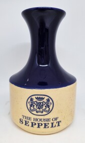
Functional object - Earthenware Bottle - House of Seppelt, Elischer Pottery, c1970
... Migrant Experience, 132 Bonegilla Road Bonegilla the-murray ...The Seppelt company was founded in the Barossa Valley in 1851 by Joseph Seppelt, a German immigrant. In 1902 the family business was registered as B. Seppelt & Sons Ltd. As part of the expansion of this successful business, they acquired the Clydeside Cellars in Rutherglen from the estate of Mr. David G. Hamilton in 1914.,Due to changing conditions the vineyards were sold in the 1980s and all stock taken back to their property at Seppeltsfield in South Australia. From 1984 until the present, the Cellars in Rutherglen has had several operators including Jolimont Cellars (Doug Shears), Tony Lamb and 2 different Asian-owned conglomerates operating as Rutherglen Estates. In 2018 Rutherglen Estate was purchased by De Bortoli Family Winemakers of Griffiths, NSWThis jug is representative of leading pioneers and companies in the Australian Wine industry located in Northeast Victoria.A ceramic wine carafe produced by the House of Seppelt. It features the coat of arms of the House of Seppelt on one side and a portrait of Benno Seppelt on the opposite side. The lower section of the carafe is beige in colour and the top half, coat of arms and portrait are in blue. THE HOUSE OF / SEPPELTb. seppelt & son, australian wine industry, northeast victorian wineries -
 Wodonga & District Historical Society Inc
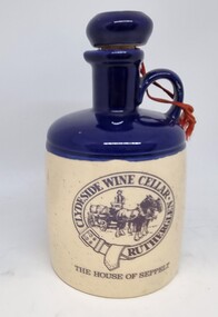
Functional object - Earthenware Bottle - Clydeside Wine Cellar Rutherglen, c1970
... Migrant Experience, 132 Bonegilla Road Bonegilla the-murray ...Clydeside Cellar was established by David G. Hamilton, a Scotsman who migrated to the Rutherglen district in 1861. He established a large business including a general store and vineyards. The Hamilton Clydeside brick cellars were built beginning in 1886 and completed in 1892. In August 1914, Messrs B. Seppelt and Sons Ltd. purchased Clydeside Cellars from the Mr. Hamilton’s estate. Due to changing conditions the vineyards were sold in the 1980s and all stock taken back to their property at Seppeltsfield in South Australia. From 1984 until the present the former Clydeside Cellar had several operators including Jolimont Cellars (Doug Shears), Tony Lamb and the 2 different Asian owned conglomerates operating as Rutherglen Estates. In 2018 Rutherglen Estate was purchased by De Bortoli Family Winemakers of Griffiths, NSW.This jug is representative of an historic and Australian Winemaker located in Northeast Victoria.An earthenware wine jug produced the House of Seppelt Clydeside Cellar at Rutherglen, VIctoria. The jug has a tradition loop handle and cork stopper.The bottom half of the jug is a traditional beige colour with a blue section. There are images in black on both sides of the jug. Originally it would have had a wax seal over the stopper to preserve effective closure to protect the contents from any chance of seepage.On front: "THE HOUSE OF SEPPELT" beneath an image of a Clydesdale drawn beer cart and driver. The image is surrounded by a representation of a horse harness containing the text "CLYDESIDE WINE CELLAR/ RUTHERGLEN" On reverse: an image of horse-drawn beer wagons and workers in front of buildings. Across the front of the building "CLYDESIDE CELLARS RUTHERGLEN / B. SEPPELT & SONS LTD."northeast victorian wineries, clydeside cellar, b. seppelt & son -
 Wodonga & District Historical Society Inc
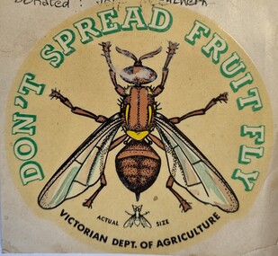
Document - Fruit Fly Border Express Pass, De Neefe Signs Pty. Ltd, c1960
... Migrant Experience, 132 Bonegilla Road Bonegilla the-murray ...The permanent fruit fly road blocks in Victoria began in 1958. The first was set up on the Lincoln Causeway between Albury and Wodonga. The aim was to protect the Victorian fruit export industry, the largest in the country. Cars would be stopped and inspected when entering Victoria. At peaks periods, such as Easter and school holidays, there were up to 10 inspectors at the 24 hour checkpoint near the former butter factory on the Lincoln Causeway. Local residents could apply for a pass such as this one which would be displayed on their window, but were still subject to random checks. Hundreds of tonnes of fruit each week was confiscated and pulverised by Department of Agriculture staff. The road block was closed in 1980, partly due to the increased traffic flows and the cost of maintaining inspection points.This image reflects government measures taken to protect the fruit industry in Victoria.A transparent sticker designed to be applied to a car window for motorists to pass through Department of Agriculture fruit fly control points. Instructions for applying the sticker to the window are written on the back of the sticker. It features a large coloured image of a fruit fly as well as a smaller life sized representation of a fruit fly.Around the edge of the circle: "DON'T SPREAD FRUIT FLY/ VICTORIAN DEPT. OF AGRICULTURE? Beside small fruit fly image: "Actual Size"fruit fly control, department of agriculture, fruit fly pass -
 Wodonga & District Historical Society Inc
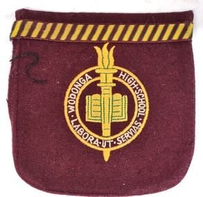
Uniform - Wodonga High School Blazer pocket and program for the new school's official opening
... Migrant Experience, 132 Bonegilla Road Bonegilla the-murray Post ...Post primary education in Wodonga began in 1923 when the existing primary school, which opened in 1857, became the Wodonga Central School. It extended students for a further 2 years of secondary schooling. In 1938 the school was declared a higher elementary school with 90 students in the secondary classes. Following rapid growth after the Second World War, the High School was established as a separate school in 1954 with 249 students and the primary students were relocated to premises in Ariel Street. However it rapidly became evident that a new school building needed to be established to cater for growing enrolments and specialist facilities. After persistent pressure from the Advisory Council, Stage 1 of the new school was built and occupied by Form 1 and 2 students in 1960. The final stages were completed during term 3, 1962. The official opening of the new Wodonga High School was declared by The Hon. J. S. Bloomfield M.L.A., Minister for Education, on Friday 30th April 1965.This program marks the an important occasion in the development of secondary education in Wodonga.A pocket from a Wodonga High School blazer made of a wool blend fabric. It is embroidered with the school logo featuring an open book and a torch combined with the school motto. The motto "Labora ut Servias", translates as "Work to Serve”. The pocket is paired with a program for official opening of the new school in 1965.Around the edge of the circular yellow, white and gold logo "WODONGA HIGH SCHOOL / LABORA UT SERVIAS"wodonga high school, secondary education wodonga -
 Wodonga & District Historical Society Inc
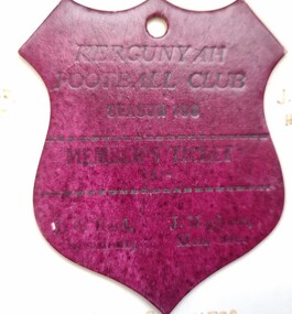
Document - Kergunyah Football Club Membership Ticket, c1970
... Migrant Experience, 132 Bonegilla Road Bonegilla the-murray ...The Kergunyah Football Club was established in 1923. They competed in several leagues including the Allans Flat District Football Association, the Yackandandah Football Association, the Dederang and District Football Association and the Tallangatta and District Football League. They won Tallangatta and District Football League premierships in 1955, 1956, 1957. Kergunyah Football Club went into recess in 1940. In 1945 the club joined the Yackandandah League, then in 1953 they were accepted into the Tallangatta and District Football League. The club closed in 1975 due to dwindling numbers but many of its remaining players become the Wodonga Demons. In 1989 Wodonga Demons were successful in their bid to be admitted to the Ovens and Murray League. Following the decision to allow the Wodonga Demons permission to join the Ovens and Murray Football League, the Wodonga Demons Football and Sports Club went about re-establishing their new identity. They had to change both their name and colours so as to not cause confusion with the Benalla Demons. The club settled upon the name of the Wodonga Raiders, officially the Wodonga Raiders Sports Club, and chose to wear red and navy colours for its playing jumpers.Card in shape of shield with issued to members of the Kergunyah Football Club.KERGUNYAH , FOOTBALL CLUB/ SEASON 19 __ / MEMBERS TICKET/ A.C.Reid President/ J. Meeham Hon. Sec.kergunyah football club, northeast victoria football, wodonga raiders football club -
 Wodonga & District Historical Society Inc
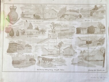
Work on paper - Sketch - The School of Military Survey, Bonegilla
... Migrant Experience, 132 Bonegilla Road Bonegilla the-murray ...Bonegilla operated as an army base from September 1940 and by 1943 was expanded to 848 buildings, including a general hospital. It provided training for small arms instructors, signallers, transport workers, bomb disposal and gas warfare personnel. In a response to the need to house the growing number of displaced persons coming to Australia, the Bonegilla Reception and Training Centre began operating in 1947. For some time it was a shared facility but the Army withdrew temporarily from Bonegilla in 1949, whilst still retaining ownership of the site. From 1949-65 Bonegilla Reception and Training Centre operated without a military presence. However, in the late 1960s and Australia’s commitments to the Vietnam War and pressed by the need to find accommodation to train men, especially National Servicemen, the Army negotiated with the Department of Immigration to take over several blocks at Bonegilla in 1965. Thirty-five huts were acquired by the Royal Australian Army Ordnance Corps as a Recruit Training Centre in which National Servicemen and recruits could attend 10-week ordnance courses. Shortly afterwards additional huts were acquired by the School of Military Survey, which established field-survey practical training areas and special astronomical observation sites as it began conducting courses in surveying. Instructors and trainees co-located at Bonegilla with migrant reception centre. In 1971 the Reception Centre closed and the site reverted to the Army. Progressively after 1971 the Army undertook a major site redevelopment with the construction of Latchford Barracks as the Army Apprentice School. Later Latchford Barracks was redeveloped into part of the Army Logistic Training Centre. Block 19 of the Mirant Reception Centre later became the Bonegilla Migrant Experience Heritage Park.This item depicts a heritage listed historical site located in the Wodonga district.A large poster size representation of the variety of buildings at Bonegilla, Victoria when it served as the location for the Royal Australian School of Military Survey. The insignia of the Royal Australian Survey Corps is featured in the top left hand corner.Top left corner: Insignia of the Royal Australian Survey Corps At bottom of sketches: "The School of Military Survey, Bonegilla Victoria / January 1966 - December 1982migrant reception centre bonegilla, army at bonegilla, australian military -
 Wodonga & District Historical Society Inc
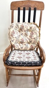
Furniture - Haeusler Family Rocking chair
... Migrant Experience, 132 Bonegilla Road Bonegilla the-murray ...The Wodonga Historical Society Haeusler Collection provides invaluable insight into life in late nineteenth and early twentieth century north east Victoria. The collection comprises manuscripts, personal artefacts used by the Haeusler family on their farm in Wodonga, and a set of glass negatives which offer a unique visual snapshot of the domestic and social lives of the Haeusler family and local Wodonga community. The Haeusler family migrated from Prussia (Germany) to South Australia in the 1840s and 1850s, before purchasing 100 acres of Crown Land made available under the Victorian Lands Act 1862 (also known as ‘Duffy’s Land Act’) in 1866 in what is now Wodonga West. The Haeusler family were one of several German families to migrate from South Australia to Wodonga in the 1860s. The Collection also depicts development of life in Wodonga through the eyes of one family, through a collection of artefacts, diaries, letters and photographs. This item is from the Hauseler Collection which documents social life of early settlers in the Wodonga community.An old wooden rocking chair, The chair was originally home manufactured from timber. The back slats have been repaired and replaced by metal slats attached at the top and base of the backrest section.early settlement wodonga, haeusler family of wodonga -
 Wodonga & District Historical Society Inc
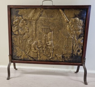
Domestic object - Beaten Copper fire screen
... Migrant Experience, 132 Bonegilla Road Bonegilla the-murray Fire ...Fire screens were developed early in the 19th century to prevent sparks from flying into the room or logs rolling out when a fire was left unattended. They also served as ornamental or decorative items, particularly ones such as this fire screen made from beaten or forged copper. Their decorations often depicted rural scenes.This item is representative of fire screens used in Australian homes to protect them from fire during the 19th and early 20th century when open fires were the main form of household heating.A fire screen made from beaten copper with a wooden frame. The screen design depicts a group of people sitting outside an Elizabethan building with a dog in the foreground and trees either side. The building is possibly a tavern as the people are seated on barrels. The frame is made from wood and has wrought iron legs screwed in place on either side and a handle attached at the centre top edge.forged copper, fire screens, decorative household items -
 Wodonga & District Historical Society Inc
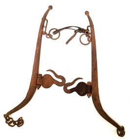
Functional object - Hames from Horse Harness
... Migrant Experience, 132 Bonegilla Road Bonegilla the-murray ...These hames are part of the harness used by the family of Michael Conway who established a dairy farm of 35 acres in Wodonga in 1940. He and his wife Catherine nee Carroll settled there and raised 5 children. Before coming to Wodonga Michael carried on a bakery business at Urana. The hames were part of the harness attached to the horse which pulled his bakery cart. In Wodonga Michael Conway built a 2 bail dairy and milked up to 20 cows, separated the cream from the milk by hand and sold it to the local butter factory of Holdensen and Nielsen. In later years only whole milk was sold. The farm was on the outskirts of East Wodonga. Michael Conway died on 6th January 1945. The farm was later sold for residential and industrial development and includes Conway Court.This item has a clear connection to the family of Michael Conway of Wodonga, Victoria2 metal sections shaped to fit around the exterior of a horse collar. They are joined at the lower end by a chain and upper end by a leather strap. Approximately halfway up each section a hinged hook is located to which chains are hooked and attached to the cart. Towards the upper end is attached a ring through which reins pass before being connected to the bit.michael conway wodonga, horse harnesses, dairy industry wodonga -
 Wodonga & District Historical Society Inc
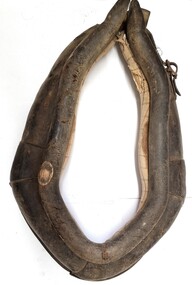
Functional object - Leather Horse Collar
... Migrant Experience, 132 Bonegilla Road Bonegilla the-murray ...This horse collar was made and used by the family of Michael Conway who established a dairy farm of 35 acres in Wodonga in 1940. He and his wife Catherine nee Carroll settled there and raised 5 children. Before coming to Wodonga Michael carried on a bakery business at Urana. This collar was used to attach the hames, harness and chains which pulled his bakery cart. In Wodonga Michael Conway built a 2 bail dairy and milked up to 20 cows, separated the cream from the milk by hand and sold it to the local butter factory of Holdensen and Nielsen. In later years only whole milk was sold. The farm was on the outskirts of East Wodonga. Michael Conway died on 6th January 1945. The farm was later sold for residential and industrial development and includes Conway Court.This item has a clear connection to the family of Michael Conway of Wodonga, VictoriaA handmade leather horse collar padded with straw and cloth. It has metal buckles secured by leather straps which are held in place with metal studs.michael conway wodonga, horse harnesses, dairy industry wodonga -
 Wodonga & District Historical Society Inc
Photograph - Codling Collection 01 - High Street Wodonga - Butcher and Tuck Shop
... Migrant Experience, 132 Bonegilla Road Bonegilla the-murray Miss ...Miss Olive Codling was a Foundation Member and a Life Member of the Wodonga Historical Society. Many of her prize-winning photos are held in the Society Collection. She also held a range of roles and committee positions in a wide range of Wodonga community organisations. These included the Horticultural Society, the Wodonga Arts Council, the Wodonga Camera Club and the Wodonga Lapidary Club. These buildings held a variety of businesses over many years. The building on the left operated as a butcher shop, but at times was also a cafe and the site of Whitehouse Motorcycles in the early 2000s. The business on the right at various times operated as "The Tuck Shop", a cafe, a milk bar and grocery shop. For a short while in the late 1930's/early 40's it was run by Sister Hughes after she had conducted the private hospital on the corner of High and Stanley Streets in the 1920's to 30's.This photo collection is significant as it documents how the businesses and buildings in Wodonga have evolved and contributed to community throughout the 20th century.A black and white image of the butcher and tuck shop near St. Augustine's convent, Wodonga.wodonga businesses, high st wodonga -
 Wodonga & District Historical Society Inc
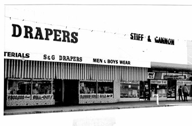
Photograph - Codling Collection 01 - High Street Wodonga East - Stiff and Gannon Feb 1920
... Migrant Experience, 132 Bonegilla Road Bonegilla the-murray Miss ...Miss Olive Codling was a Foundation Member and a Life Member of the Wodonga Historical Society. Many of her prize-winning photos are held in the Society Collection. She also held a range of roles and committee positions in a wide range of Wodonga community organisations. These included the Horticultural Society, the Wodonga Arts Council, the Wodonga Camera Club and the Wodonga Lapidary Club. Stiff & Gannon General Store, Hardware, Draper and Grocery Merchants was located in High Street, Wodonga. The business opened in August 1946 and closed on 28 February 1970. This photo collection is significant as it documents how the businesses and buildings in Wodonga have evolved and contributed to community throughout the 20th century. A black and white of Stiff & Gannon in High Street, Wodonga taken February 1970.wodonga businesses, high st wodonga, stiff & gannon -
 Wodonga & District Historical Society Inc
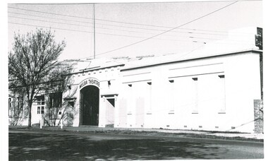
Photograph - Codling Collection 01 - Melba Theatre Wodonga and its Demolition
... Migrant Experience, 132 Bonegilla Road Bonegilla the-murray Miss ...Miss Olive Codling was a Foundation Member and a Life Member of the Wodonga Historical Society. Many of her prize-winning photos are held in the Society Collection. She also held a range of roles and committee positions in a wide range of Wodonga community organisations. MELBA THEATRE, WODONGA operated in the Shire Hall building on the corner of High Street and Melbourne Road (Elgin Street), Wodonga. The Shire Hall was built in 1890. The date on the facade of the building represents the date of the formation of the Shire in 1876. In December 1929, Enterprise Pictures were screening films in the open air theatre adjacent to the Shire Hall or sometimes in the hall itself. In 1943 “Melba Theatre, Shire Hall” was advertised with that name for the first time. In 1948 Mr K Bounader, a picture proprietor from Holbrook with 39 years in pictures behind him assumed control of the Melba Theatre, Wodonga. The Bounader family continued to run the theatre well into the 1960s. The hall was also used for functions such as school socials and concerts. Competition from drive-in theatres and television had an impact on theatre audiences. Finally, the Melba Theatre screened its last film in 1968. A school speech night in 1969 is the last known event in the Melba Theatre. It was demolished along with the Shire Hall in 1971 and replaced with a supermarket and car park.These images are significant as they document an historic buildings in Wodonga which played an important part in the social life of the community.2 black and white photos of the Melba Theatre in Wodonga and its demolition Over doorway: "MELBA THEATRE"high st wodonga, melba theatre, wodonga buildings -
 Wodonga & District Historical Society Inc
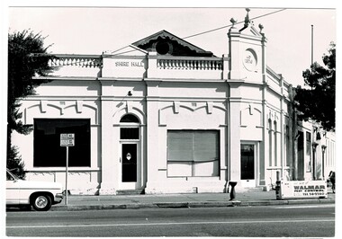
Photograph - Codling Collection 01 - Wodonga Shire Hall
... Migrant Experience, 132 Bonegilla Road Bonegilla the-murray Miss ...Miss Olive Codling was a Foundation Member and a Life Member of the Wodonga Historical Society. Many of her prize-winning photos are held in the Society Collection. She also held a range of roles and committee positions in a wide range of Wodonga community organisations. These included the Horticultural Society, the Wodonga Arts Council, the Wodonga Camera Club and the Wodonga Lapidary Club. Wodonga Shire was created in 1876 when the colonial government agreed to ratepayers' petitions to have their part of the local government district severed from the Yackandandah Shire to form a new municipality. After meeting for 14 years in rented premises, in the Prince of Wales Hall, Wodonga Council built its first Shire Hall on the corner of High and Elgin Streets in 1890. The date on the facade of the building represents the date of the formation of the Shire.This image is significant as it documents an important building and era in the development of local government in Wodonga.Wodonga Shire office at corner of High street and Melbourne Road Built 1876 demolished 1971 . Now the location of Woolworths shopping complex. Also incorporated the Melba Theatre On facade of building: " A.D. 1876"high st wodonga, wodonga local government, shire hall wodonga -
 Wodonga & District Historical Society Inc
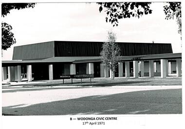
Photograph - Codling Collection 01 - Wodonga Civic Centre
... Migrant Experience, 132 Bonegilla Road Bonegilla the-murray Miss ...Miss Olive Codling was a Foundation Member and a Life Member of the Wodonga Historical Society. Many of her prize-winning photos are held in the Society Collection. She also held a range of roles and committee positions in a wide range of Wodonga community organisations. These included the Horticultural Society, the Wodonga Arts Council, the Wodonga Camera Club and the Wodonga Lapidary Club. Wodonga Civic Centre - In the late 1960s the area in Wodonga between Hovell and Havelock Streets was zoned for civic purposes. By 1969 Melbourne architect Bruce Marshall had designed the civic centre which included a library, theatre and senior citizens' rooms. The main hall had a seating capacity of 1,000 people but could be divided by a sliding door. into smaller areas. It also included meeting rooms and kitchen facilities. The Civic Centre was officially opened by the Honorable Sir Henry Bolte, K.C.M.P., M.P., Premier of Victoria who was accompanied by the Honorable R. J. Hamer E.D., Minister for Local Government. The Shire President was Cr. James A. Terrill, J.P. This image records an important stage in the development of local government and civic buildings in Wodonga, Victoria.A series of black and white images showing the constriction and opening of the Wodonga Civic centre.wodonga businesses, high st wodonga, melba theatre -
 Wodonga & District Historical Society Inc
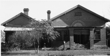
Photograph - Codling Collection 01 - Wodonga's First Court House
... Migrant Experience, 132 Bonegilla Road Bonegilla the-murray Miss ...Miss Olive Codling was a Foundation Member and a Life Member of the Wodonga Historical Society. Many of her prize-winning photos are held in the Society Collection. She also held a range of roles and committee positions in a wide range of Wodonga community organisations. COURT HOUSE - Wodonga's first court house was a timber building constructed in 1859. In January 1877, a contract was let to add the brick building to the existing structure. This court house opened in June 1877. This gabled court house was designed by architect Peter Kerr and was constructed at a cost of £1,325. It served as the court house until it was replaced in 1920. It was then used as a private residence for many years. At various stages it was also operated as a restaurant, a real estate agency, an antique shop and currently operates as commercial offices.This photo collection is significant as it documents how the businesses and buildings in Wodonga have evolved and contributed to community throughout the 20th century.A black and white image of the original Court House and Police paddock. Also an image of the "Court" sign, a view of the back of the building and a present day colour image of the building.wodonga businesses, high st wodonga, wodonga court house -
 Wodonga & District Historical Society Inc
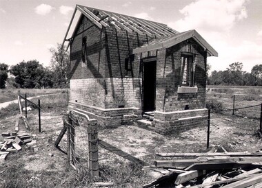
Photograph - Codling Collection 01 - Wodonga Powder Magazine
... Migrant Experience, 132 Bonegilla Road Bonegilla the-murray Miss ...Miss Olive Codling was a Foundation Member and a Life Member of the Wodonga Historical Society. Many of her prize-winning photos are held in the Society Collection. She also held a range of roles and committee positions in a wide range of Wodonga community organisations. THE WODONGA POWDER MAGAZINE was built by Edward Hope in 1877-78 to the order of the Ministry of Trade and Customs. It was built of brick and contains a brick arched ceiling vault to absorb any explosion The Wodonga Powder Magazine stored explosives for use in deep lead gold mining and public works in the district. The original construction cost £330.05.6. In 1993, at a cost of $27,000, Wodonga City Council employed Anton Iskra to carry out restoration of the Powder Magazine.This photo collection is significant as it documents a building which played a significant role in Wodonga and has a local heritage overlay.Black and white images of the ruins of the Wodonga Powder Magazine.wodonga powder magazine, gateway island wodonga, historic buildings wodonga -
 Wodonga & District Historical Society Inc
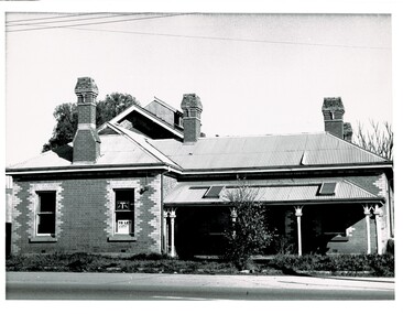
Photograph - Codling Collection 01 - Wodonga's Second Police Station
... Migrant Experience, 132 Bonegilla Road Bonegilla the-murray Miss ...Miss Olive Codling was a Foundation Member and a Life Member of the Wodonga Historical Society. Many of her prize-winning photos are held in the Society Collection. She also held a range of roles and committee positions in a wide range of Wodonga community organisations. WODONGA'S SECOND POLICE STATION - This building was located on the west side of High Street near the railway line at the corner of High Street and Bond Street. The building in the background was the Bond Store which was later repurposed to become the Court House. This Police Station, which began operation on this site c1905, had originally been the house of the customs officer. It had a front office and a Sergeant's and an Inspector's office as well as 2 barrack rooms and a laundry at the rear. In the backyard was a blue stone cell block and a night soil toilet, as well as a stable used previously for horse and carriage. Opposite the police station was a boarding house which supplied meals to prisoners. This police station was in use until its move to Elgin Street, Wodonga in December 1967.This photo collection is significant as it documents how the businesses and buildings in Wodonga have evolved and contributed to community throughout the 20th century.Two black and white photos of the 2nd Police Station built in Wodonga with the former Bond Store in the background.high st wodonga, police stations wodonga -
 Wodonga & District Historical Society Inc
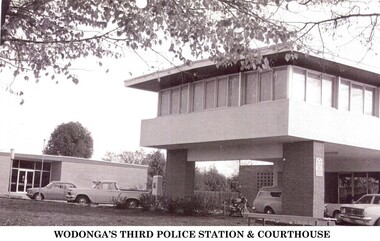
Photograph - Codling Collection 01 - Wodonga's 3rd Police Station and Court House
... Migrant Experience, 132 Bonegilla Road Bonegilla the-murray Miss ...Miss Olive Codling was a Foundation Member and a Life Member of the Wodonga Historical Society. Many of her prize-winning photos are held in the Society Collection. She also held a range of roles and committee positions in a wide range of Wodonga community organisations. WODONGA's 3rd Police Station and Court House were constructed in Elgin Street, Wodonga. The Court House had to be relocated after the earlier building had been destroyed by a fire in 1964. In 1966, the new Wodonga Police Station was built but lay empty and idle for about three months. The reason given was that no furniture was available. After this situation was remedied the station was opened on December 23, 1966. The previous police station was vacated and pulled down. The new station was built in front of the new court house, which had been operating for approximately 12 months. The Police and Court House continued to operate on this site until they were again relocated in 2002. They are now located in Hovell Street, Wodonga.This photo collection is significant as it documents how the businesses and buildings in Wodonga have evolved and contributed to community throughout the 20th century.2 images of the 3rd police station built in Wodonga with the courthouse in the background.wodonga businesses, wodonga police station, wodonga court house -
 Wodonga & District Historical Society Inc
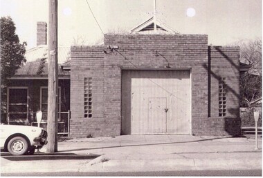
Photograph - Codling Collection 01 - Wodonga Fire station and CWA Hall
... Migrant Experience, 132 Bonegilla Road Bonegilla the-murray Miss ...Miss Olive Codling was a Foundation Member and a Life Member of the Wodonga Historical Society. Many of her prize-winning photos are held in the Society Collection, including a series of photos of buildings in High Street (formerly Sydney Road), Wodonga. The CWA Hall officially opened in 1938 having been built on land granted by the Wodonga Council. Wodonga Infant Welfare Centre also occupied part of the building until 1959. Last meeting of the CWA in that hall was in held in December 1983, with the Council resuming ownership of the land to build the current day Post Office. Country Fire Brigade’s new fire station opened in High Street on 31st March 1940. The building comprised an appliance room for housing the fire engine and plant. The floor had been especially treated to enable dancing when the occasion warranted. There was a meeting room, a station-keeper’s bedroom and a repair shop. A shower room and modern kitchen were also included. The Fire station relocated to Smythe and Stanley Street corner which opened in 1977. They have now relocated to Thomas Mitchell Drive, Wodonga.This photo collection is significant as it documents how the businesses and buildings in Wodonga have evolved and contributed to community throughout the 20th century.A series of black and white photos depicting the Fire Station and CWA hall located in High Street, Wodonga C1940 - 1983wodonga businesses, high st wodonga, wodonga fire brigade, wodonga country women's association, cwa wodonga -
 Wodonga & District Historical Society Inc
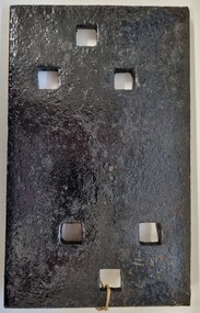
Functional object - Rail fish plate from Cudgewa Line, 1930 - 1960s
... Migrant Experience, 132 Bonegilla Road Bonegilla the-murray ...Cudgewa Line -The Cudgewa railway line opened in stages between 1889 and 1921. The first section from Wodonga to Huon opened on 10 September 1889. It was extended to Bolga on 18 July 1890, Tallangatta on 24 July 1891, Shelley on 13 June 1916 (the highest station in Victoria), Beetomba on 10 April 1919 and Cudgewa on 5 May 1921. The line had 1 in 30 grades and trestle bridges that have been heritage listed. In 1919, the line was used to carry materials for the construction of Hume Weir, and three years later a spur line connecting Ebden to the weir was opened. In the 1960s, Cudgewa became the railhead of materials for the Snowy Mountains Scheme. The last passenger service from Wodonga to Tallangatta ran on 30 September 1961. The turntable and passenger platform at Cudgewa were abolished in 1976. This fish plate came from the rails of the Cudgewa Line at Gordon Roy's hut which was situated behind Perry's Stump Hotel outside Wodonga. The hut was used as an office with the points lever outside to switch trucks to different tracks on the Bandiana and Cudgewa lines.This item is significant as it was part of the railway line to Cudgewa which played an important role in North east Victoria carrying freight during the construction of the Hume Weir and the Snowy Mountains Scheme.A section of flat plate. These plates were used in pairs to connect the ends of adjacent rails in railway track. victorian railways, cudgewa rail line, railway components -
 Wodonga & District Historical Society Inc
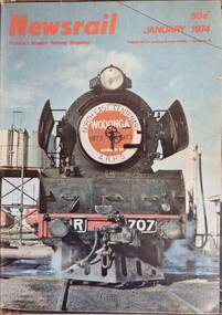
Magazine - Newsrail magazine, Victorian Division of the Australian Railway Historical Society, 1974
... Migrant Experience, 132 Bonegilla Road Bonegilla the-murray ...Newsrail is a monthly railway magazine covering the railways and tramways of Victoria. This publication was launched in January 1973 by the Australian Railway Historical Society's Victorian Division. It replaced the Divisional Diary magazine which had been published since November 1957. It includes features on both rural and metropolitan railways and contains articles and photographic presentations. Our collection includes all issues from January until December 1974. This featured item from January 1974 includes an article and photograph of the Northeast Railway Centenary celebration train, R707, to Wodonga. The magazine is still in publication in 2023.A magazine featuring articles and news items from the Australian Railway Historical Society's Victorian Division. Each issue is in the same format and includes a coloured photograph on the cover.non-fictionNewsrail is a monthly railway magazine covering the railways and tramways of Victoria. This publication was launched in January 1973 by the Australian Railway Historical Society's Victorian Division. It replaced the Divisional Diary magazine which had been published since November 1957. It includes features on both rural and metropolitan railways and contains articles and photographic presentations. Our collection includes all issues from January until December 1974. This featured item from January 1974 includes an article and photograph of the Northeast Railway Centenary celebration train, R707, to Wodonga. The magazine is still in publication in 2023.locomotive r707, newsrail magazine, wodonga railway centenary -
 Wodonga & District Historical Society Inc
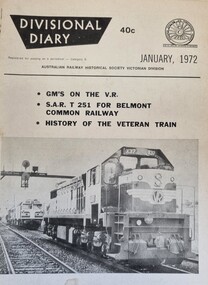
Journal - Divisional Diary, Australian Railway Historical Society, Victorian Division, 1972
... Migrant Experience, 132 Bonegilla Road Bonegilla the-murray ...A publication by the Australian Railway Historical Association. Victorian Division from November 1957 until December 1972. In 1973 it was superseded by the Newsrail Magazine which remains in publication. Some articles related to the Tasmanian rail network were also included.A magazine featuring articles, illustrations and images related to the development of the Victorian Railways and events taking place at the time of publication.A publication by the Australian Railway Historical Association. Victorian Division from November 1957 until December 1972. In 1973 it was superseded by the Newsrail Magazine which remains in publication. Some articles related to the Tasmanian rail network were also included.victorian railways, railways tasmania, railways history -
 Wodonga & District Historical Society Inc
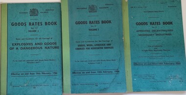
Manual - Victorian Railways Goods Rates Books 1966, Victorian Railways Printing Works, 1966
... Migrant Experience, 132 Bonegilla Road Bonegilla the-murray ...These 3 volumes were issued by the Victorian Railways to all railway stations outlining changes made to goods and freight rates to operate in Victoria as of 14th February 1966. They were significant publications as they itemised the first rates after the introduction of decimal currency to Australia.3 Volumes of information to Victorian Railways Goods Rates under a range of categories. They have blue board covers and had cloth binding. Print on the cover and throughout the books is in black ink. Much of the information is in tabulated format.These 3 volumes were issued by the Victorian Railways to all railway stations outlining changes made to goods and freight rates to operate in Victoria as of 14th February 1966. They were significant publications as they itemised the first rates after the introduction of decimal currency to Australia.victorian railways, victorian railway rates -
 Wodonga & District Historical Society Inc
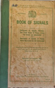
Manual - Victorian Railways Book of Signals, Victorian Railways Printing Works, 1967
... Migrant Experience, 132 Bonegilla Road Bonegilla the-murray ...This manual was issued by Victorian Railways in 1967 to explain all of the railway signals used throughout Victoria. It included a detailed outline of the signals used at every railway station, including small depots and sidings throughout Victoria. Illustrations of the different signal systems are included in the text. Every driver, fireman, guard, shunter, and every other employee designated by the Head of the Branch concerned, had to be supplied by his superior officer with a copy of this book. They were required to become thoroughly acquainted with the particulars which related to their duties. The included informations was effective from 3rd August, 1967 until further notice.A beige coloured book with green binding. The cover includes the Royal Coat of Arms, a summary of the purpose and contents of the manual, and the date the instructions become effective, all printed in green ink. This information is enclosed by a green border. non-fictionThis manual was issued by Victorian Railways in 1967 to explain all of the railway signals used throughout Victoria. It included a detailed outline of the signals used at every railway station, including small depots and sidings throughout Victoria. Illustrations of the different signal systems are included in the text. Every driver, fireman, guard, shunter, and every other employee designated by the Head of the Branch concerned, had to be supplied by his superior officer with a copy of this book. They were required to become thoroughly acquainted with the particulars which related to their duties. The included informations was effective from 3rd August, 1967 until further notice.victorian railways, victorian railways -- rules and practice., railway signals -
 Wodonga & District Historical Society Inc
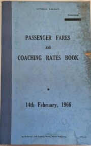
Manual - Passenger fares and coaching rates book, V. R. Printing Works, 1966
... Migrant Experience, 132 Bonegilla Road Bonegilla the-murray ...This is a manual issued by the Victorian Railways to all railway stations to outline changes made to passenger and freight rates to operate in Victoria as of 14th February 1966. These changes were significant as it itemised the first rates after the introduction of decimal currency to Australia.A blue covered document published on white paper outlining changes to rates on Victorian Railwaysnon-fictionThis is a manual issued by the Victorian Railways to all railway stations to outline changes made to passenger and freight rates to operate in Victoria as of 14th February 1966. These changes were significant as it itemised the first rates after the introduction of decimal currency to Australia.victorian railways, victorian railways -- rules and practice., public transport victoria, victorian railways fares and rates -
 Wodonga & District Historical Society Inc
Manual - Locomotive Diesel Training Manual Module 5, VLine, c1990s
... Migrant Experience, 132 Bonegilla Road Bonegilla the-murray ...This training module was available to enginemen who had completed Modules 1 to 5 (1983 Scheme). The manual contained fault finding checklists and standard procedures to be carried out if faults occured. Every driver was required to be conversant with and follow the instructions. Enginemen issued with this manual had to carry it with them at all times when in charge of a diesel electric locomotive.A module of reading and requirements for the training module. The pages are kept within a vinyl covered 2 ring binder. Text is printer on white paper and contains illustrations.fictionThis training module was available to enginemen who had completed Modules 1 to 5 (1983 Scheme). The manual contained fault finding checklists and standard procedures to be carried out if faults occured. Every driver was required to be conversant with and follow the instructions. Enginemen issued with this manual had to carry it with them at all times when in charge of a diesel electric locomotive. vline safety, vline training, railways victoria -
 Wodonga & District Historical Society Inc
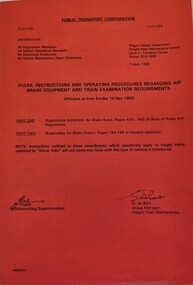
Manual - Public Transport Corporation Memo 7541, Public Transport Corporation Victoria, 1993
... Migrant Experience, 132 Bonegilla Road Bonegilla the-murray ...The Public Transport Corporation (PTC) was a Victoria State Government owned statutory authority formed under the Transport Act 1983 which operated passenger and freight trains, trams and bus services. It was established on 1 July 1989. This memo was effective as from Sunday 16th May, 1993 and pertained to rules instructions and operating procedures regarding air brake equipment and train examination requirements. As noted on the cover: "Part One - Supersedes Automatic air brake rules, pages 479-495 of Book of rules and regulations. -- Part Two - Supersedes Air brake orders, pages 189-198 of General appendix." The cover bears the signatures of M. Digging, Safeworking Superintendent and G. De Bont, Group Manager, Freight Fleet Maintenance.A booklet with a red cover and black print. There are extensive instructions on the cover which include distribution details and dates on which these instructions came into effect,fictionThe Public Transport Corporation (PTC) was a Victoria State Government owned statutory authority formed under the Transport Act 1983 which operated passenger and freight trains, trams and bus services. It was established on 1 July 1989. This memo was effective as from Sunday 16th May, 1993 and pertained to rules instructions and operating procedures regarding air brake equipment and train examination requirements. As noted on the cover: "Part One - Supersedes Automatic air brake rules, pages 479-495 of Book of rules and regulations. -- Part Two - Supersedes Air brake orders, pages 189-198 of General appendix." The cover bears the signatures of M. Digging, Safeworking Superintendent and G. De Bont, Group Manager, Freight Fleet Maintenance.locomotive manuals, victorian railways, public transport corporation victoria, victorian railways -- rules and practice. -
 Wodonga & District Historical Society Inc
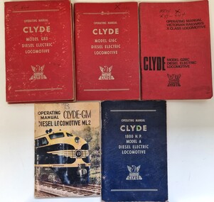
Manual - Operating Manuals for Clyde Diesel Locomotives
... Migrant Experience, 132 Bonegilla Road Bonegilla the-murray ...This collection of Diesel Locomotive Manuals was published by the Clyde EngineeringA collection of 5 manuals for a range of Clyde Diesel Locomotives. The collection includes instructions for the Clyde G8B, G16C, G26C, 1800 HP Model A and the Clyde Mailiner Model 2. On the cover of each manual, the owner has written the letter for the name of class which the relevant locomotive was ascribed in Victoria. The Clyde Engineering Company Limited was registered on 30 September 1898 in New South Wales. It was one of the iconic Australian engineering firms whose history spanned just over a century and was one of the few locomotive and rolling stock builders in the world that transitioned from steam to diesel to electric traction. The company was formed by Walter Maplesden Noakes who purchased the works of Hudson Brothers Limited in the Sydney suburb of Granville, which had been established by in 1882. The manuals refer to the following locomotives:- Clyde Model G8B which operated in Victoria as the new T class locomotive. It was introduced in 1955 and was the most numerous class of diesel locomotive used in Victoria. This model continued in operation until 1968, although many were modified for continued service. Clyde Model G16C, later superseded by the G26C operated in Victoria as the X class locomotive between 1966 and 1976. Clyde Model 1800HP Model A became the S class locomotives in Victoria. Additional numbers were purchased in preparation for the opening of the standard gauge line between Melbourne and Albury, They entered service between 1957 and 1961. Clyde Mainline Model 2 became the B class in Victoria. The B class were the first mainline diesel-electric locomotives in Victoria entering service in June 1952. They were initially used on the main passenger and freight services, before moving out to other areas. They remained in service until the early 1990s.fiction This collection of Diesel Locomotive Manuals was published by the Clyde Engineeringclyde engineering, diesel locomotives, locomotives victoria