Showing 1282 items
matching back creek
-
 Kiewa Valley Historical Society
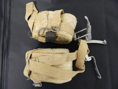
Ski Skins - Pair
Ski skins and webbing were introduced into the Victorian Alps by European skiers. Enthusiasts travelled to enjoy the snow and to explore the Victorian Alps including the Bogong High Plains. This equipment enabled them to travel over snow without slipping when going up hills. They took the skins off when they wanted to slide down hills. In later years waxes were used for cross country skiing and then 'fish tail' markings on the back of skis to enable skiers to travel distances up and down mountains. Later developments also included motor transport (replacing horses to get to the snow line) and roads to take skiers to the ski fields and mechanised tows to take skiers up mountains so they could ski down (downhill skiing).Skiers visited the Bogong High Plains especially during the years of the State Electricity Commission of Victoria's construction of the Kiewa Hydro Electric Scheme from the 1930's onwards. Tourists to the area increased during this time and influenced the development of Falls Creek.Long cream strips with soft short 'fur' on one side and a type of strong hessian on the back with the length of the middle and sides stitched. At one end an adjustable strap is attached to a steel, hinged clasp and at the other end is a loop that fits over the ski. A quarter of the way from each end is a steel attachment for fastening over the ski - the 'toe' end with a rubber embossed flap and the other with a short and long strap each with a steel ring at the end.On the rubber attachment: 'vinersa/pat uno'ski skins; bogong high plains; falls creek -
 Kiewa Valley Historical Society
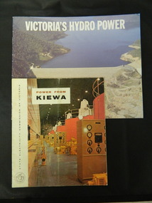
Booklets - Kiewa Hydro Electric Scheme, 1. "Power From Kiewa" and 2. "Victoria's Hydro Power", 1. Made in July 1968 and 2. Made in Aug. 1985
1. The State Electricity Commission of Victoria built the Kiewa Hydro Electric Scheme from the 1930's to the 1960's. This booklet was to inform visitors and to promote tourism. 2. The State Electricity Commission built several hydro power stations from 1928 - 1981. This booklet names each with a summary and explanation.The State Electricity Commission of Victoria built the Kiewa Hydro Electric Scheme establishing infrastructure such as the Bogong and Mt Beauty townships and the opportunity for tourism in the area.1. Colored soft cover with photo of McKay Creek Power Station on the front and Mt Beauty township on the back. Published by the SECV 2. Colored soft cover with Rocky Valley Dam on the front and inserted photo of a stream and snow on the back. Published by the SEC.state electricity commission of victoria; kiewa hydro electric scheme; victoria's hydro electric power; kiewa; mckay creek power station; clover power station; west kiewa power station -
 Kiewa Valley Historical Society
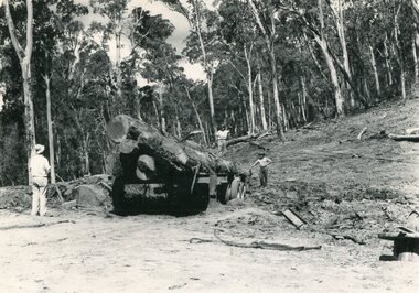
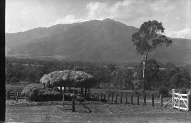
Photo - Mountain Creek Logging Camp, 1955
... Handwritten on the back of photograph - MOUNTAIN CREEK... on the back of photograph - MOUNTAIN CREEK LOGGING CAMP NOV 55 Black ...Hume and Hovell discovered the area in 1824 and by the end of the 19th century the valley was transformed by logging, dairy and beef cattle properties and tobacco farms. The logs could have been milled for timber at the State Electricity Commission's mill at Howman's Gap which provided a much needed source of timber for construction of McKay Creek Power Station which began construction in 1951 and also the camps and houses for the workers and their families. There was a need for housing and infrastructure for an increasing population of workers for the hydro-electric scheme as there was a general shortage of this commodity. A timber mill was started in Tawonga by Mates, of Albury, in 1945, and electricity became available in 1946 the S.E.C. bought the mill, and enlarged it. In 1960 it was purchase by a local family, they also started a timber mill in Mt Beauty worked both until 1980 when they closed it. The Tawonga mill and enlarged the mill called Mt. Beauty Timbers Pty Ltd employed approximately 50 people. An historical pictorial record of the general working conditions, type of machinery and vehicles in use in the 1950’s. Note the lack of protective clothing!Black and white photograph of the logging camp at Mountain Creek. November 1955Handwritten on the back of photograph - MOUNTAIN CREEK LOGGING CAMP NOV 55mountain creek logging camp, timber industry, tawonga -
 Kiewa Valley Historical Society
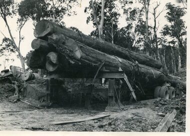
Photo - Logging. Mountain Creek, November 1955, November 1955
Hume and Hovell discovered the area in 1824 and by the end of the 19th century the valley was transformed by logging, dairy and beef cattle properties and tobacco farms. The logs could have been milled for timber at the State Electricity Commission's mill at Howman's Gap which provided a much needed source of timber for construction of McKay Creek Power Station which began construction in 1951 and also the camps and houses for the workers and their families. There was a need for housing and infrastructure for an increasing population of workers for the hydro-electric scheme as there was a general shortage of this commodity. A timber mill was started in Tawonga by Mates, of Albury, in 1945, and electricity became available in 1946 the S.E.C. bought the mill, and enlarged it. In 1960 it was purchase by a local family, they also started a timber mill in Mt Beauty worked both until 1980 when they closed it. The Tawonga mill and enlarged the mill called Mt. Beauty Timbers Pty Ltd employed approximately 50 people An historical pictorial record of the general working conditions, type of machinery and vehicles in use in the 1950’s. Black and white photograph of logging at Mountain Creek November 1955Small typed note attached to the back of photo - Logging Mountain Creek November 1955mountain creek logging camp, tawonga, timber industry -
 Kiewa Valley Historical Society
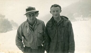
Photograph - Mt Bogong - Tawonga, 06/05/1937
Mount Bogong located in the Alpine National Park and part of the Victorian Alps of the Great Dividing Range, is the highest mountain in Victoria, Australia, at 1,986 metres (6,516 ft) above sea level. The Big River separates the massif of the mountain from the Bogong High Plains to the south. From the nearby town of Mount Beauty to its summit, Mount Bogong rises more than 1,600 metres (5,200 ft), thus making it one of the highest peaks in Australia not only in terms of its elevation above sea level, but also in terms of actual base-to-summit prominence. Mount Bogong is a popular backcountry skiing mountain through winter but only has snow for the mid winter-spring months. It is around 30 kilometres (19 mi) by road and walking track or 12 kilometres (7.5 mi) direct to Mount Beauty. Falls Creek and Mount Hotham ski resorts are also nearby. Camping is relatively safe below the tree line but the summit ridgeline is very exposed. Emergency shelter is also available at Bivouac Hut on the Staircase Spur, and at Cleve Cole, above Camp Creek on the broad ridge to the south of the summit, and Michells Hut on the Eskdale Spur. Mt Bogong is a popular recreational venue in the Kiewa Valley for back country skiing and bush walking and is a favourite with sightseers and popular subject for photographersBlack and white photograph of Mt bogong taken from Tawonga - Thursday May 6th, 1937Handwritten on back of photograph. Thursday May 6th, 1937. Mt Bogong Tawongamt bogong, tawonga, kiewa valley -
 Kiewa Valley Historical Society
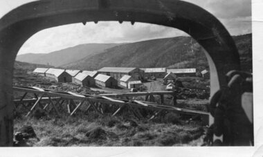
Photograph - Pretty Valley camp including workman's huts, Pretty Valley
At the Pretty Valley Dam site erection of staff quarters was completed in April, 1947 and accommodation for workmen commenced in 1948 but suspended on 11th May for winter and resumed on 9th November. Construction of this camp was completed in 1949. A large dam was proposed at this site but was never constructed. Instead a small diversion dam was built which diverts water either to Rocky Valley Dam or to McKay Creek Power Station.An historical record of the type of accommodation provided for workmen during the construction of the Kiewa Hydro Scheme during the 1940's/50'sBlack and white photograph of Pretty Valley camp showing workman's huts and construction materials.Handwritten on back of photograph in blue pen - Pretty Valleypretty valley, workmen's huts, victorian alps, secv -
 Kiewa Valley Historical Society
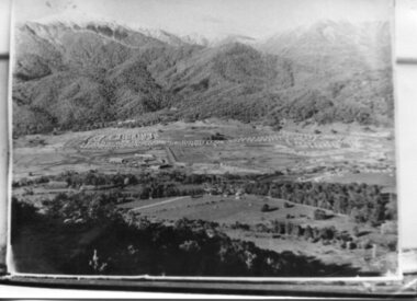
Photograph - Mt Beauty Camp, Estimated 1950-1951
This photo is of the very newly constructed State Electricity Commission town of Mt. Beauty. The houses up to Nelse street were erected from 1946 onward and then the township was extended beyond Nelse Street in 1950 which places this photograph about 1950/51. There is no evidence of work being commenced on the regulating pondage but the tail race canal can be seen on the centre right of photo. The workmen's camp was enlarged in 1950 to the extent of providing accommodation for a total of 1,200. There are a number of dwellings on Simmonds Creek and the road to Falls Creek can clearly be seen. Snow capped Mt. Bogong is in the upper left of the photo with Mt. Beauty behind the township rising to Big Hill beyond that.Shows the newly constructed town of Mt. Beauty surrounded by farmland and before the regulating pondage was built to discharge water from the power stations via the West Kiewa tail race tunnel into the Kiewa River. Copy of black and white photograph of Mt Beauty CampWritten on the back in black ink - A Campenmt beauty camp, secv, construction town -
 Kiewa Valley Historical Society
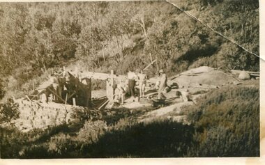
Photograph - Building of Myrtleford Ski Club
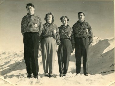
... Snow sports Victorian Alps Falls Creek Handwritten on the back ...Myrtleford Ski Club is a non-commercial, family friendly club. It was one of the earliest lodges to be built at Falls Creek and was one of the earliest ski clubs formed and celebrated its 75th anniversary in 2013. In 1949, Myrtleford Ski Club obtained permission for occupancy and began planning the MSC Lodge. There were only three other huts on the mountain, Bogong Ski Club in an old Army hut, Skyline as the Ski Club of Victoria lodge and the Albury Ski Club lodge. The lodge was built mostly from donated materials. The basement was dug out and lined with stone from the Ruined Castle area, timber was cut (using cross-saws) from the Walpole properties and was milled then carted up to Falls Creek on either the Walpole or Calvert trucks. The iron on the roof was originally a tobacco kiln on Billy McNamara's property. The lodge has undergone many improvements over the years including a second storey added in the 1950’s, updating of accommodation, shower and toilet facilities to meet the changing needs of members. The lodge now caters for 38 people in a variety of shared rooms from two to eight beds per room. Toilet and shower facilities are also shared. The club has a Lodge Managers for the winter season. Myrtleford Ski Lodge was one of the earliest ski lodges built in the Falls Creek area in 1938. It is an excellent example of early sporting and community activities in the Upper Kiewa Valley area. Photograph shows family members, including women, involved in the construction.Sepia photograph of the building of the Myrtleford Ski Club about 1948Handwritten on the back of photograph in black pen - Building Myrtleford Ski Club (about 1948) Stamped on back of photograph - 6 2511myrtleford ski club, skiing, snow sports, victorian alps, falls creek -
 Kiewa Valley Historical Society
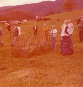
Photograph of pioneer grave, 29th May, 1977
Pictorial record of the grave of pioneer woman Mrs Mary Hollonds, who passed away in 1862. The grave is located at Mullagong Station (farm) in Tawonga, five miles south of Keegan's Bridge. Miss Hobbs, formerly of Running Creek, mentioned that twin babies of the Brigg's family are buried at Mary Holland's feet.Pictorial record of pioneer gravesites in the Kiewa Valley. Social history of people in 1977 showing interested in local historyColour photograph of group visiting the grave of pioneer woman Mrs Mary Hollands at Mullagong on 29th May, 1977Handwritten in faint blue ink on back of photograph: Mrs Mary Holland's grave. Died 1862 Mullagong. 29th May, 1977kiewa valley, mullagong station, tawonga, hollonds family, brigg's family -
 Kiewa Valley Historical Society
3 X photographs of early residents of the Kiewa Valley, 1. 1949-1950
The 3 photographs are of early residents of the Kiewa Valley who have pursued varying careers. Pictorial history of early residents of the Kiewa Valley giving an insight into the accomplishments of some local residents ie: R Nicholls and T Hotter travelled from New Zealand to work in the Kiewa Valley. J.H. Thompson pursued a career as a police officer. W.M. Sloan and his father built the water wheel at Junction Creek.1. Black and white photograph of Rod Nicholls and Tom Hotter, both of Mt Egmont New Zealand 2. Black and white photograph of J.H Thompson Former pupil of Mongan’s Bridge School 3. Black and white photograph of W M Sloan taken in 1880’s. Photograph is an oval within a larger rectangle 1. Handwritten in black pen on back of photo – Rod Nicholls (wearing hat) & Tom Hotter Both of Hawera (Mt Egmont) New Zealand 1949 – 1950 2. Handwritten on the back of photograph in ink J H Thompson, A fond memory for Mrs. Fisher, Everil & Paddy. Former pupil of Mongan’s Bridge school 3. Handwritten on back of photograph in blue ink – W M Sloan. He and his father built the water wheel 1880’s on Junction Creek (Bakers) j h thompson, fisher family, mongan's bridge, w m sloan, kiewa valley -
 Kiewa Valley Historical Society
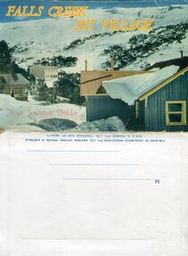
Souvenir Postcard Folder – Falls Creek Ski Village
After World War II, the Kiewa Hydroelectric Scheme was started in the Kiewa River valley by the State Electricity Commission of Victoria. On land previously used only for summer cattle grazing in the natural alpine grasslands, the first ski lodge was built in 1948 by workers from the scheme. The first lift, a rope tow, was built in 1951 and the first chairlift in Australia was constructed there in 1957. Falls Creek Post Office opened on 9 June 1958 (with telegraph and telephone facilities only until 1964) .Despite strong opposition from the head of the Kiewa scheme, who didn't want tourists clogging up his roads and destroying his "dry" construction camps by bringing in booze, Falls Creek boomed as much as Hotham, partly owing to its relatively good access road. Early lodges included Bogong (c.1946), Skyline (1947), Albury (1949), Myrtleford (1949) and Dawn (c.1950).The souvenir postcard photographed and produced by an enterprising local businessman Mr S K Pearce, was produced as a memento for skiers and other visitors to the Falls Creek and Mt Beauty area to send to family and friends as a reminder of their visit to the region, or to keep as a personal souvenir. It presented an excellent promotional opportunity for enterprising local businessmen to promote the area to skiers and tourists near and far. It also presents an excellent pictorial history of the falls creek area around the late 1950’s to early 1960’sColour postcard folder (unused) containing 13 photographs of the Falls Creek ski area and surrounds. Inside cover has a brief description of the area and the services available to visitors Printed on front cover- FALLS CREEK SKI VILLAGE. Your Souvenir Folder Photo of skiing slopes of the village Inside front flap - a brief description of the Falls Creek area and the services available to visitors 1. Diana Lodge parking area and Spion Kopje 2. Winterhaven Lodge 3. Ski Hirage Centre and skiing slopes 4. Ski Lodges from main road 5. Nelse and Arundel Lodges 6. Day visitors’ shelter and parking area 7. Summit T-Bar lift 8. Spur T-bar looking towards Village and Spion Kopje 9. T-bar lower station and Snow Crystal Inn 10. ‘Akja’ rescue sled in use 11. Falls Creek road and Grand Coeur Lodge annex 12. Rope tows and beginner slopes 13. Back cover- Published by Nucolorvue Pty Ltd Mentone Vic. Printed in Australia For S.K.Pearce Pty Ltd Tawonga and Mt Beauty falls creek, snow, bogong high plains, victorian alps -
 Kiewa Valley Historical Society
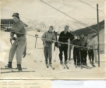
Photographs – Skiers at Falls Creek – Set of 10 black and white photographs
After World War II, the Kiewa Hydro-Electric Scheme was started in the Kiewa River valley by the State Electricity Commission of Victoria. On land previously used only for summer cattle grazing in the natural alpine grasslands, the first ski lodge was built in 1948 by workers from the hydro scheme as skiing was a popular recreation. Many of the hydro employees were of European background and had grown up enjoying skiing and snow sports in their homelands and were keen to continue to pursue their winter sports interests. The first lift, a rope tow, was built in 1951 and the first chairlift in Australia was constructed there in 1957. Two T-Bars were opened in 1961. In 1964, the Victorian Municipal Directory recorded that Falls Creek had 29 ski club lodges and 16 commercial lodges.Employees of the State Electricity Commission of Victoria in the Kiewa River Valley were the earliest skiers on the Bogong High Plains and built one of the first ski lodges at Falls Creek. They were amongst those pivotal in the development of the skiing and tourist industry at Falls Creek and on the Bogong High Plains. Set of 10 black and white photographs of various skiers at Falls Creek Victoria1. From Left-John Robertson Myrtleford; Bill Bridgford, St Trinians; Girl not known; Roy Wolpole, Myrtleford; Fin McAuliffe, Myrtleford; Looking on foreground, Toni St Elmo 2. Falls Creek. Property of State Electricity Commission of Victoria Publicity Photo Negative No PB4046. Publicity Branch, 15 William St Melbourne. 3. Avic Lajons 4. No markings 5. Bill Bridgeford (lower person on slope) 6. Max Lawrence? Facing skiers 7. 6575. Indistinguishable red stamp on back 8. 6875. Ces Dobson on tractor 9. From left on tow. John Robertson (Myrtleford); Bill Bridgeford (St Trinians); Girl unknown; Roy Walpole (Myrtleford); Vin McAuliffe (Myrtleford); Looking on foreground Toni Beveridge. 10. From Left 1; 2; 3. Bill Bridgeford; 4. George McPherson ? (Myrtleford); 5. John Robertson (Myrtleford); 6. Elsbeth Rollenson? (Myrtleford); 7; 8; 9. 11. Bogong. Looking N.E from Big River fire track. Skiers on way to Falls Creek. Spion Kop on left. Going around Ropers Cerner near the 18 mile post falls creek, skiing, bogong high plains -
 Kiewa Valley Historical Society
Photographs – Skippy St Elmo and other skiers – Set of 8 black and white photographs
Skippy and Toni St Elmo were responsible for early developments at the Falls Creek resort and for promoting a love of skiing. They left Melbourne in 1945 and settled at Falls Creek and moved into the first building constructed of corrugated iron and timber at Falls Creek in 1946. They were Falls Creek’s first workers with Toni employed by the State Electricity Commission to record weather-related data up to the construction of the Kiewa Hydro-Electric Scheme. In 1957, Toni was involved in building the first rope tow called Nissen on the same route as the Summit Quad. He also established the Nissen Ski School with ski instructor Milan Kovacic and was involved in the building of the resort’s first ski club Bogong in 1949. Toni taught Skippy to ski and she practised on the High Plains where she and her husband lived. Skippy St Elmo won many ski races during the 1950’s and represented Australia in New Zealand.Skippy and Toni St Elmo were pioneers of the Falls Creek area, promoting local ski sports and tourism. The played an important role in opening up the Falls Creek area and developing its sporting potential by establishing the first ski school, ski lifts and early lodge facilities. Skippy and Toni St Elmo were honoured at the Alpine Village at Falls Creek on November 17 2006, with the spreading of their ashes at the place which played such an important part in both their lives.Set of 8 black and white photographs of Skippy St Elmo and other skiers 1. Skippy and 3 others in New Zealand 1951 2. Skippy and 5 others Falls Creek 1955 3. Cake celebrating 20 years of sport at Nissen Lodge 4. Skippy and friend outside Nissen Lodge 5. Skippy on the ski slopes 6. Skippy on the ski slopes 7. Albury Ski Club team New Zwealand 1957 8. The Bogong Ski Club 1950 Written on back of photos 1. Bob Howe Albury, Skippy New Zealand 1951 – 942H 2. Falls Creek 1955. Skippy St Elmo: H Devonassore; Margaret ?; ?; Tony St Elmo; Olive? 3. Written on cake Nissen Alpine Club. 20 years of sport. FRED 4. Skippy St Elmo 5. Skippy 6. Skippy 7. Bob Howe (Albury) Skippy New Zealand 1957. Albury Ski Club Team raced in NZ 8. The Bogong Ski club, Coronet Park, 1950. M Denham (Capt); B Wiltshire; R Roberts; Skippy St Elmo; Gwen Morris; J Frazer; J Smith; L Piera; Manager & Coach Toni St Elmo. J D Knowles Photographer Box 188, Queenstown. 744B falls creek, skiing, bogong high plains -
 Kiewa Valley Historical Society
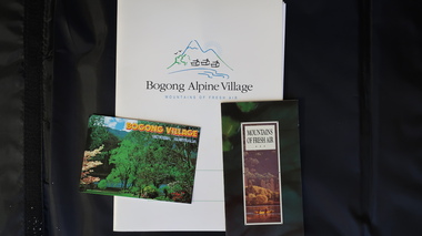
Papers - Bogong Village & the 'Commissioner's' Lodge & Progress Association Members, c 1997/1998
Bogong Village was built by the SECV in 1940 for the workers of the Kiewa Hydro Electric Scheme. In 1971, 30 houses were furnished for use as holiday homes for SEC personnel throughout the State. From 1989 to 1993 the houses were restored & renovated.During the 1990s the buildings in the village had been leased to private owners. Many of them rented their houses for tourists. The Commissioner's lodge was on the other side of the Mt Beauty - Falls Creek road, above Bogong Village. Wally Baldwin ran it in the 1960's.It was destroyed by the 2003 bushfires.These papers present a history of 'the Commissioner's lodge' and Bogong Village in the 1990's. The Progress Association was an active community group in 1963/64.Papers advertising Bogong Village & the Lodge for accommodation with rates 1997/1998. Describes the alternatives, maps and cafe hours, Also, 'Jan's Recollections' and on the back of these pages a hand written list of members of the the Progress Association 1963-64 as 'per Mr A. McCullough's spiel'. In original folder and includes a pamphlet & postcard.bogong village, secv lodge, lake guy, state electricity commission of victoria., kiewa hydro electric scheme, tourism, accommodation -
 Kiewa Valley Historical Society
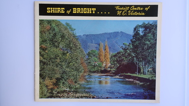
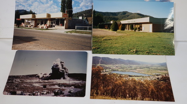
Brochure - Shire of Bright, Shire of Bright Tourist Centre of N.E. Victoria, Pre 1966
Bright and the surrounding towns were developing a large tourism industry which the Shire of Bright continues to promote, encouraging tourists to visit throughout the year. This high quality brochure has magnificent photos with a map showing the area and the distance (in miles) from the centre - the township of Bright.This brochure is promoting the Shire of Bright encouraging tourism in the area. This is important for the Shire as tourism is the main industry for the Shire. It is interesting to see how tourism has changed (or not) in the area.14 pages on glossy paper including colored and black and white photos. The front cover has the title at the top with yellow print on black background. Below the title is a large colored photo of a river, autumn trees and mountain. The back cover is a large colored photo of a man amongst the snow gums in the snow. The towns covered are Bright, Wandiligong, Eurobin, Mt Buffalo, McKay Creek Power Station, The Kiewa Hydro Electric Scheme, Mt Beauty, Kiewa, Bogong including tourist destinations in these areas and their surrounds.tourism; mt beauty; the kiewa valley; bright shire -
 Kiewa Valley Historical Society
Booklet - Victoria's Hydro Power x2, Victoria's Hydro Power - SEC, August 1975
The State Electricity Commission of Victoria built several hydro power stations from 1928-1981. This book names each - up to 1975 - with a summary and explanation.The State Electricity Commission of Victoria built the Kiewa Hydro Electric Scheme which included the construction of Bogong Power Station, McKay Creek Power Station and West Kiewa Power Station. It also established infrastructure such as the townships of Bogong and Mt Beauty and the opportunity for tourism in the area Colored green/blue 'splash' of water on front cover with SEC logo in white centred under the yellow printed title. On the back cover is the SEC logo at the bottom in the middle.state electricity commission of victoria; kiewa hydro electric scheme; mckay creek power station; clover power station; west kiewa power station -
 Kiewa Valley Historical Society
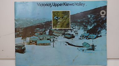
Booklet - SEC x2, 1. Victoria's Kiewa Valley 2. Victoria's Upper Kiewa Valley, No. 2 is dated October 1978
The State Electricity Commission of Victoria built the Kiewa Hydro Electric Scheme and was keen to promote tourism in the area. The booklet includes Facilities, Falls Creek Ski Resort, the Kiewa Works Area, the Three Floras of Bogong, the Geology of the Kiewa area, the Bird and Animal life of Bogong and the Kiewa Hydro Electric Scheme. The colored photos and the map on the back appeal to the reader/tourist.The SECV promoted tourism in the Kiewa Valley especially the area of the Kiewa Hydro Electric Scheme. This booklet is attractive and informative with a lot of detail. This proved to be the early stages of tourism in the area in what is now a very popular tourist destination and the main industry for the Upper Kiewa Valley.Blue cover with photo of Falls Creek at night. Title in black print at the centre top under which is an insert photo of a blue wren and SEC logo in white towards the top far right. Back cover is light green with a tourist map of the area. The text is complimented with brightly colored photos throughout.state electricity commission of victoria; kiewa hydro electric scheme; tourism; bogong; flora; fauna; geology; -
 Kiewa Valley Historical Society
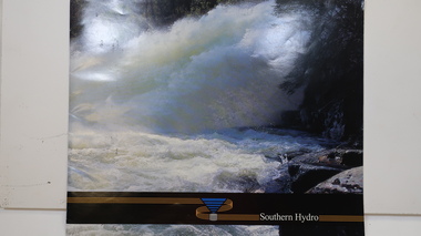
Booklet - Southern Hydro, Southern Hydro
Southern Hydro Ltd. was established in the late 1990s as a result of the disaggregation of the former State Electricity Commission of Victoria. It operates 10 power stations mainly in the north-east of VictoriaSouthern Hydro continued to encourage tourism as did the former State Electricity Commission of Victoria. This brochure is very similar to one previously published by the SECV "Victoria's Hydro Power" except only including those that it operates. Within the KHES the power stations were McKay Creek, Clover and West Kiewa. The change of ownership of hydro power from a government body to private enterprise in the late 1990s is of significant interest to the historian and consumer.Colored photo water spraying onto rocks with black strip across the bottom and logo (4 gold lines forming an "S", a blue triangle with grey cylinder beneath) of Southern Hydro within the strip. Back cover has a similar photo with 4 small photos of men inserted in the black column. This 23 page book gives a history of Southern Hydro and its 10 hydro-electric power stations that it operates. The book lists these and gives a description of each.Top right hand corner of page 5 has a piece of tape stuck over the print with "Page 11 to photo copy & enlarge" secv; khes; mckay creek power station; clover power station; west kiewa power station; mount beauty; rocky valley dam; -
 Kiewa Valley Historical Society
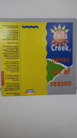
Brochure - Falls Creek Tourism, Falls Creek Never Out of Season
Falls Creek is a Ski Resort in the north east of Victoria. This brochure has been produced to encourage tourists to visit throughout the year.Tourism to the Kiewa Valley is an important industry for the area. Falls Creek is a ski resort with accommodation during winter for skiers, snow boarders and other snow sports. It involves entertainment, restaurants and associated workers. This brochure is produced to promote the resort throughout the year to increase the occupancy of these lodges. The tourist industry has increased steadily with fishing, cycling and bush walking increasing numbers in the area.Glossy square brochure folded in in half and half again. Front page is yellow on the left with black print on the far left. The right side has the title with blue, green and grey background with yellow, orange and white as part of the title. The back is a man standing in front of a sunset with print in a column towards the right side. Inside includes a map with advertisements for accommodation surrounding it.falls creek ski resort; alpine region in victoria; mountain lodges; -
 Kiewa Valley Historical Society
Photograph - 30 black and white photographs (assorted sizes) plus page from a newspaper and copied article on A4 paper, c1880's c1910 - 1920 (photographs) Newspaper 1961
... : handwritten in ink, back of photo "Running Creek Cricket Team". F1... stream". K4 - no inscription. K5: handwritten in ink, back ...K2,3 and4 are of the Kiewa River and two of the bridges spanning the river along the valley. K3 and K4 would have been taken in the 1880's and show the type of trees and plant growth along the river prior to land clearing for farming. K5 is of the Running Creek Cricket Team and therefore there was sufficient population in the area to form and maintain a team as well as have other teams in the relatively near vicinity to provide competition. Note the horse drawn cart which provided transport. Date taken is unknown but possibly c 1910. The Mt. Buffalo Chalet was built in 1910 by the Victorian Government. It was Australia's first ski resort and has served generations of skiiers, hikers and families over the years. It was built for 3195 pounds and has had stories and wings added since and is the largest timber building in Australia. B4 is the earliest photo in this group as the garden is in early stages of development - the other photos show the growth of the shrubs and would be taken about c 1920. Note the cars and motor bikes. It closed in 2006. The other photos are of general interest only but interesting to see that there were donkey's grazing. There is no information as to their purpose on Mt. Buffalo. Four different Kiewa Valley families are represented in the photographs. Their descendants still live in the Valley and carry on the traditions of beef and dairy farming. Of particular interest is the photo of Miss Marjorie Clemence, the first School Teacher of Upper Gundowring School. Gundowring pastoral run was taken up in 1838 and occupied by framers in the 1860's. The area was known as Gundowring and Upper Gundowring. The Gundowring School was opened in 1871 and most likely the Upper Gundowring school would be built at the same time. It was School No. 2733 and situated in Boyd Road. It closed in 1953 when the Kiewa Consolidated School opened. The newspaper page describes the activities in which the local community of Kergunyah were in engaged in that period - Red Cross, Fire Brigade, cattle round up and some of the identities involved. The article photocopied from the Yackandandah times states that he (Norman Coad) "was sent to the Ovens District Hospital, Beechworth for treatment" which would mean that this was the closest hospital to the Kiewa Valley for emergencies in 1912.The Kiewa Valley photographs are of social significance showing two of the early bridges allowing the community easy access to both sides of the river and also the tree and plant growth before land clearing for farming. The photos of Mt. Buffalo Chalet have social, architectural and historical significance. the Chalet has been used by skiers, bush walkers and day trippers since its completion in 1910 and its closure in 2006. It is listed in the Victorian Heritage Register. The family photographs are of social and historical significance as they are of early farming families in the Kiewa Valley and also depict the dress, of both men and women) in the late 1880's. The write up in the Weekly Times has social significance as it depicts the social and farming activities and photos of the local residents from around that area. The article from the Yackandandah Times is of a personal nature with concern for the individual involved. Note: There is a photo of the gentleman mentioned in the article (Mr. Norman Coad) in the Families of the Kiewa Valley (F4) as above.30 black and white photographs - 5 of the Kiewa Valley, 8 of families of the Kiewa Vallley and 17 of Mt. Buffalo. Various sized photos. Page from the Weekly times and copied article from the Yackandandah Times on A4 sheet.(Note for easier identification they have been numbered and grouped - K1-5 (Kiewa Valley), F1-8 (Families) and B1-17 (Mt. Buffalo). K1: handwritten in ink, lower L hand corner "Bogong in the distance". K2: handwritten in ink lower L hand corner "Mongan's Bridge or Towonga". K3 handwritten in ink "Taken from Mongan Bridge looking up stream". K4 - no inscription. K5: handwritten in ink, back of photo "Running Creek Cricket Team". F1: handwritten in ink on back "Mrs. Heap" and lower down in pencil "1880's". F2 handwritten in pencil at top of back phot "Land at Tawonga TROVE The Y'dah Times 20/2/1913" and lower down in ink "Henry Ellis Larkin". F3: handwritten in ink bottom edge "Mrs Coad". Note that this photo is a postcard. F4: Written in ink lower edge "Norman Coad". Note this photo is also a postcard. F5: Lower left corner in Ink "Harry Larkin". F6: lower half back of photo, in ink "Bernie Maddison". F7: on back of photograph in ink "Miss Marjorie Clemence first School Teacher Upper Gundowring: and underneath, in pencil "C1880's". F8: Handwritten in ink on back of photo "Frank & Mrs. Keat & Lesley of Tawonga". Lower down in pencil "c1912-1914". B1: Back of photo in ink "The Chalet Mt. Buffalo". B2: no inscription. B3: "chalet at Bufflo" in ink lower left corner. B4: This is a post card. Written in ink is "Mt. Buffalo Chalet". B5 - B10 printed in ink, lower left corner "Buffalo". B11: no inscription. B12: "Mt. Buffalo" lower R corner. B13: "Buffalo?". B15: Printed in ink lower edge "Picnic at Buffalo". B16: "Donkeys on Mt. Buffalo" printed in ink lower edge. B17: handwritten in ink across back of photo "Donkeys & top of Mt. Buffalo with the Monileith in the distance". A4 sheet of paper describing an accident to Mr. Norman Coad. Under article is : Yackandandah Times (Vic: 1890 - 1931), Thursday 18 July 1912, page 3. A page torn from the Weekly Times, June 14, 1961 and entitled "Kergunyah has picturesque setting". kiewa valley, farming, families, kergunyah, gundowring upper, mt. buffalo chalet, briggs family, larki family, coad family, clemence family, laskowski collection -
 Kiewa Valley Historical Society
Photo Collection - Wally Howell, Falls Creek and Kiewa Hydro Electric Scheme including Mt Beauty
1. Falls Creek ski resort is on the Bogong High Plains 2. Kiewa Hydro Electric Scheme (late 1940s to early 1960s) was constructed by the State Electricity Commission of Victoria and included the townships of Bogong and Mt Beauty. The photos were taken by Wally Howell.Falls Creek is at the head of the Kiewa Valley and a major tourist attraction. Kiewa Hydro Electric Scheme was constructed by the SECV and included the creation of the Mt Beauty township.1. 16 Coloured photos of Falls Creek - not dated or labelled. Includes Malony's Ski Hire & Restaurant and Sundance Inn 2. 162 Coloured Photos not dated or labelled. Includes Kiewa Hydro Electric Scheme and Mt Beauty. Some multiple copies. 1. "Processed by Kodak Oct. 85 M" on printed in red ink on the back of one photo. Also, later labels were added in ink to identify each photo.falls creek, snow resort, skiing, ski lodges, sundance inn, malony's ski hire, spargos lodge, t-bar lifts, mt beauty, tourism -
 Kiewa Valley Historical Society
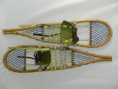
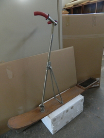
Snow Shoes
Snow shoes were used to move between places on the snow fields at Falls Creek and the Bogong High Plains especially during the construction of the Kiewa Hydro Scheme.Historical: Snow shoes were used on the Bogong High Plains during winter. The body is made of light wood 'bamboo' with a back and front wooden cross bar. Between the front cross bar and toe, blue nylon is tied to form diamonds 'lacing', similarly the back. Between the bars, in the middle is cream coloured rope tied to form a strong basket. A shoe harness made of olive green vinyl to which is clipped brown strong woven material tape with a circular steel loop through which the tape is threaded. There are 3 steel fasteners on 1 side and 2 on the other with a black plastic fastener. At the front between the cream and blue woven baskets there is a gap called the toe hole. The rope is attached either side of the toe hole to the front wooden bar.snow. falls creek. bogong high plains. transport. victorian alps. -
 Kiewa Valley Historical Society
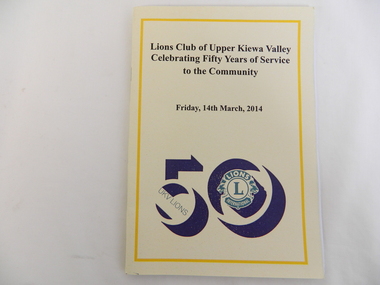
Book - Lions Club, Lions Club of Upper Kiewa Valley Celebrating Fifty Years of Service to the Community, 2014
The Upper Kiewa Valley Lions Club has served the Kiewa Valley for 50 years - raising money for the community. Its biggest success was the 'Snack Bar', a food outlet at Falls Creek, selling hot pies and coffee. From 1964 in a caravan, to 1965 - 1971 in a bus the snack bar operated, until it was sold in 1989. The book also outlines their other projects and office bearers.The Upper Kiewa Valley Lions Club involved local people and local events giving an insight into the development of the area over the last 50 years. Yellow soft covered book fastened by 2 staples. Deep yellow line outlines the cover with black print of title and date. Thick black "50" with Lions logo in green is enclosed by the 0 (in the 50). Back cover - also outlined with a deep yellow line. On the top middle is "50" including the logo surrounded by the "0" and underneath the words "We Serve".On page 9 "Ian Howley 2010/11"lions club, upper kiewa valley, 50 years, service club, community, snack bar at falls creek, conquestathon -
 Kiewa Valley Historical Society
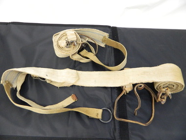
Seal Skins Ski Straps / Soles
Seal skin straps and webbing were introduced into the Victorian Alps by European skiers. Enthusiasts travelled to enjoy the snow and to explore the Victorian Alps including the Bogong High Plains. This equipment enabled them to travel over snow without slipping when going up hills. They took the skins off when they wanted to slide down hills. In later years, waxes were used for cross country skiing and then 'fish tail' markings on the back of skis to enable skiers to travel distances up and down mountains. Later developments also included motor transport (replacing horses to get to the snow line) and roads to take skiers to the ski fields and mechanised tows to take skiers up mountains so they could ski down (downhill skiing). Skate skiing has also developed as another form of skiing.Skiers visited the Bogong High Plains during summer and winter to explore and enjoy the High Plains. The equipment used was a forerunner to the variety used today and the different types of skiing done today. Falls Creek was developed during the construction of the Kiewa Electric Hydro Scheme and was influenced by the number of Europeans working on the scheme and their desire to make use of the snow during winter.Each Seal skin has: Seal skin sewn onto one side of a strap of webbing. There is a webbing loop on the front that slips over a small point at the front of the ski. There is a webbing strap attached to the back of the seal skin sole coming over the back of the ski that clips metal fasteners onto a loop of webbing behind the boot.skiing. snow. high plains. seal skins. cross country skiing. alpine sports. -
 Kiewa Valley Historical Society
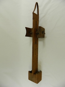
Ski Boot Carrier x 2
Ski boots were carried by wooden carriers when transporting ski equipment eg. from transport to snow line or accommodation. The boots had a lip at the front and back to enable them being clipped onto ski bindings and boot carriers.These ski boot carriers indicate the type of equipment that used to be used by skiers skiing on the High Plains and Falls Creek. It is also an example of the inventiveness and skill of people who made their own equipment that either couldn't be bought or wasn't available locally. A pair of wooden ski boot carriers made from light wood. The wood is thick at the heel end with an overhang for the heel of the boot. It has a thin leather strap at the toe end and an adjustable clamp at the toe end. The adjustable part consists of a clamp on either side of the wood held by 2 nuts that screw towards each boot . This clamp can slide up and down the hollow groove in the wood. One boot fits on each side of the wood. Reused wood with old marksski boots. snow. high plains. falls creek -
 Kiewa Valley Historical Society
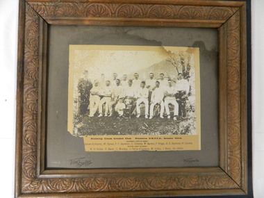
Photo - Running Creek Cricket Club
Running Creek belonged to the Upper Kiewa Valley Cricket Association and were premiers in 1913 - 1914. They dressed in whites with long sleeved shirts and trousers. The umpire was dressed very formally. The names of the players are local families and included brothers or relations with the same surname.Historical: Running Creek were premiers of the Upper Kiewa Valley Cricket Association in 1913 - 1914. Their team consisted of local men some of whom were related. The occasion was important enough to have a photo and to remember it possibly hanging the photo up in a public place eg. club rooms.Black & white photo of Running Creek Cricket Team, Premiers 1913 - 1914. Upper Kiewa Valley Cricket Association Far left - The umpire fully dressed in suit & hat and far right man with white shirt & black trousers. In between 13 cricketers in 2 rows and a child beside the cup at the front. Names of players are typed below the photo. Photo is glued on grey cardboard, framed in brown decorative wooden frame. Back: String attached 1 side only.Title, names of players. Grey cardboard - Vine's Studios / Wangaratta. On back handwritten "Donated by Mrs J. Woodside / Guluguba / Queensland / on 19 July 1972cricket. running creek. upper kiewa valley cricket association. sport. vine's studio. -
 Kiewa Valley Historical Society
Snow Scooter
There are many ways of travelling over snow - skis, toboggans, sleds, using snow shoes, machines, horses etc. This 'snow scooter' appears to have been handmade for faster transport (than walking) over snow. Machines with engines 'snow mobiles' are more commonly used nowadays. This snow scooter was possibly used at Falls Creek for moving around the village during winter.Wooden plank curved and lifting at the front and at the end of the back an attached small rectangular wooden framed plastic grid (for non slippery foothold). Underneath plank - at front is a metal rudder that swivels when the handle is turned and at the back are 2 metal fixed 'rudders'.At the front, on top, is a metal stand forming a triangle (for stability) with a steel rod which goes through the plank to the front rudder and up to a bicycle type handle at the top. The handle has red plastic handle grips on the ends. The join of the metal bars half way up is with a butterfly nut. snow scooter; snow transport; falls creek -
 Kiewa Valley Historical Society
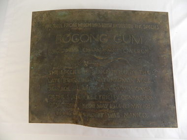
Plaque - Eucalypt Chapmanania, 1947
W.D.Chapman had a keen interest in botany and was particularly interested in Eucalyptus species. He was first to discover the tree which now bears his name on his numerous visits to the Kiewa power station which is situated near the Bogong High Plains. He was a Commissioner and later the Chairman of the State Electricity Commission of Victoria, the organisation in charge of building the Kiewa Hydro Scheme. The tree is a cross between two eucalypts. The trees are unique as they cannot procreate. There were two 'Bogong Gum' trees. One at Cranky Charlies and one on the way up to the High Plains passed by the Ryder family on their way up.This plaque was beside the Falls Creek Road and indicated the location of the 'Bogong Gum' tree. The tree was burnt in the 2003 bush fires but survived only to be killed in the 2006 bush fires. There were two 'Bogong Gum' trees. One at Cranky Charlies and one on the way up to the High Plains passed by the Ryder family on their way up. Heavy bronze plaque embossed with inscription. On the back is a large rectangular steel piece bent at the bottom to form a 'U' shape. One end of the 'u' is attached to the plaque and the other end has two holes for bolts enabling the plaque to be attached near the tree. One bolt is in a hole."Type tree from which was first described the species / Bogong Gum / (Eucalyptus Chapmaniana, Cameron) / The species was identified by the / late Brigadier W. D. Chapman M.C.E., / D. Eng., M.I.E. Aust., M.I.C.E. Lond. Commissioner / of the State Electricity Commission / of Victoria from May 1944 to May 1955, / in his honour it was named."plaque; state electricity commission of victoria; w.d.chapman; eucalyptus; bogong gum tree; falls creek road -
 Warrnambool and District Historical Society Inc.
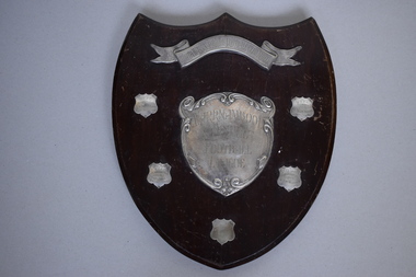
Shield, 1947
This trophy has been presented to the Warrnambool & District Football League by the South Warrnambool Football Club. This latter club still plays in the Hampden Football League and dates back to the 1880s and possibly beyond and has always been a traditional rival of the Warrnambool Football Club. West End Football Club dates back to the 1890s and joined with the Allansford Football Club in the 1960s to form the West End Allansford team. In 2001 the name ‘West End’ was dropped from the club’s name. Russells Creek Football Club was established in 1931 and still plays in the Warrnambool & District Football League which dates back to the early 1900sThis football trophy is of interest as it comes from the mid 20th century and concerns two local Warrnambool football clubs still existing today and one club that no longer exists.This is a wooden trophy in the shape of a shield. It has a silver scroll on the top and a silver heart shape in the middle. There is a cord on the back of the shield attached by metal hooks for hanging purposes. There are five small shields with etched writing on four of these. The shield is a little scratched. ‘South Warrnambool Football Club Shield’ ‘Warrnambool & District Football League’ ‘R.C.F.C. Premiers 1947 Tom Zanos (Captain) H. Drewitt (Coach)’ ‘W.E.F.C. Premiers 1948 P. Lake Capt. & Coach G.R.Thomas Pres.’ ‘W.E.F.C. Premiers 1949 W.L. ‘Jack’ McMurrick Capt. & Coach’ ‘West End F.C. Premiers 1950 W.L. McMurrick Capt. & Coach’ south warrnambool football club, warrnambool & district football league -
 Warrnambool and District Historical Society Inc.
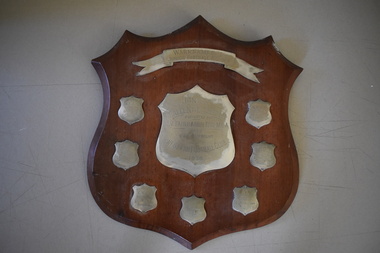
Trophy, Junior Challenge Shield 1936, 1932
This junior football shield was given by James Fairbairn (1897-1940), a prominent Western District pastoralist, aviator, local politician and Federal Cabinet minister. He was killed in a Canberra air disaster in 1940. The shield shows that several football teams, including West End, Russells Creek and East Warrnambool won the shield in the 1930s. In 1936 the shield was won outright by West End Football Club. This club, founded in the late 19th century, played in Western District Leagues until 1946 when it joined the newly-formed Warrnambool District Football League. In 1971 it merged with the Allansford Football Club to become the West End-Allansford Club and in 2002 the name ceased to exist when the team name was changed back to Allansford Football Club. This trophy is of interest as a football trophy given over 80 years ago and as a memento of the Warrnambool West End Football Club, a team no longer existing. The sport of Australian football has been, and still is, highly prominent in the Warrnambool district with football first played in the town in 1861. This is a wooden shield with nine silver-coloured metal discs affixed to the shield with metal pins. Eight of these discs are shield-shaped. All of the discs have etched inscriptions. The discs are somewhat stained and the wooden shield has traces of paint on it. There is a wire attached to the back of the shield for hanging on a wall. ‘Warrnambool Junior Football League’ ‘Junior Challenge Shield presented by J.V. Fairbairn Esq. M.L.A. 1932’ ‘Won Outright West End Football Club 1936’ west end football club, warrnambool, j.v.fairbairn