Showing 634 items
matching school property
-
 Eltham District Historical Society Inc
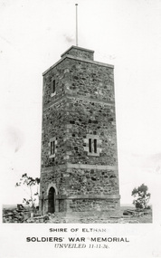
Photograph, Tom Prior, Shire of Eltham, Soldiers' War Memorial, unveiled 11-11-26
Note the unfinished state-stones at base. Honour Roll not yet erected. Before the memorial was erected there was a cairn of rocks to commemorate Armistice Day. All travel was mostly by walking and school children walked to town each November 11 Memorial Service.The Reynolds family were early settlers in Research. The Reynolds/ Prior collection of photographs were taken by Tom Prior, the maternal uncle of Ivy Reynolds, around 1900 and the 60 photos in the album give a fine overview of many of the landmarks of Research and Eltham over 100 years ago. lvy lived in the family home for many years at 106 Thompson Cres Research. Ivy's father, Ernst Richard Reynolds and grandfather, Richard Reynolds, lived at the same address. Ivy's father Richard worked for Mr. Trail on his property in Research. Reynolds Road is named after the family. Mr Tom Prior (wife Eva) worked at the Melbourne zoo. He was very innovative and made his own camera, using the black cloth hood to exclude the light. The photographs are a reminder of the rural nature of Research and Eltham and its rich heritage. Black and white photograph mounted in an album, the Reynolds/Prior Photograph Collection, this being one of 53 reproduced black and white images of early Eltham.The Reynolds/Prior Photograph Collection, Presented to the Eltham District Historical Society, 14 June 2006 by Ross McDonald. A second copy was also presented to the Andrew Ross Museum, Kangaroo Groundreynolds prior collection, kangaroo ground, war memorial -
 Eltham District Historical Society Inc
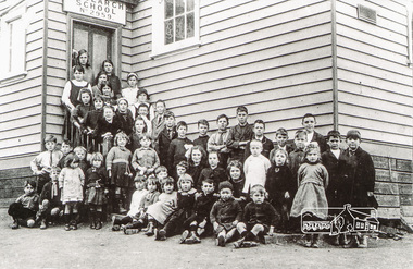
Photograph, Class of 1922, Research State School No. 2959
The Children of Research State School in 1922 Photo and list of children provided by Ivy Reynolds to Ross McDonald. Ross has supplemented and filled in some blanks, from the children names in Andrew Lemons book 'Return to Research. A centenary of Research Primary School, 1989 ' page 103. Additional commentary provided by Ivy Reynolds in 2006. 1. Winnie La Frenz - a great friend of the Reynolds 2. Ruth Thompson - Wally Buttwell's niece 3. Bertha Wiltshire 4. Ivy Dickson (who grew up to be a good-looking woman) 5. May Norman - a cousin to the Reynolds through Ernest Reynolds 6. Elsie Shaw 7. Veenie Turner (Ivy was not 100% sure of her surname, but said she was not related to Hazel Turner) 8 Lil La Frenz (Lilian) - a bright spark and a lively tennis player 9 Lily Wilson (looks like a boy) - had red hair 10 Hazel Turner - a cousin of the Reynolds who lost her mother very early in life. Her father remarried and the family then became Roman Catholics, which in those days, caused them to become distant with the Anglican Reynolds family 11 Lila Dickson (Lyla) 12. Jack Wilson - a red-head like his sister 13. Len Blashick 14. Marjory Palmer 15 ? Burgoyne 16 Lance Doney and 17 Bill Doney. Cleaver boys who went to Ivanhoe Grammar. Both caught TB from their mother and died young. 17. Bill Doney - The Doneys were clever boys. They went to Ivanhoe Grammar after Research Primary and this educational advantage caused them to grow apart from the local boys. Both caught tuberculosis from their mother and didn't live long. Lance died first, but Bill survived long enough to join the Merchant Navy. He eventually entered the Mont Park Sanatorium where Ernest Reynolds used to visit him every Sunday. The Doney boys were keen on Margaret and Ivy Reynolds at one stage (probably before they became seriously ill) and Bill gave Ivy a macrame belt he'd made. 18 ? Burgoyne 19 ? Messen (Frank or Alex Masson) 20 Neville West 21 ? Shaw 22 ? Shaw 23 Neil Palmer 24 George Shaw or his brother Bertie 25 George Shaw or his brother Bertie 26 Eva Kilson 27 Lorna Turner 28 ? Henry Fox (or possibly Eric?) 29 Nancy Storey (adopted) 30 Mona Fox 31. Nell Storey (also adopted) She married Sam Howard and they had 2 daughters. One went to Queensland, the other lived locally and helped at the Research Anglican Church. 32 Victor Davey 33 Margaret Reynolds 34 Ethel Davey - cousin of the Reynolds through Ernest Reynolds 35 ? Randall (Freddie) 36 ? Randall (Kitty) -Their father was a builder who made toys for every child at the school one Christmas 37 Ronnie Turner 38 ? Ivy couldn't remember his name, but thought he lived at the Research Hotel 39 John Reynolds 40 Jim Davey 41 Unknown 42 Ivy Reynolds 43. Unknown - one of the unknown boys is Jimmy Storey 44. Unknown 45. Unknown 46. Dorothy La Frenz 47. Eric Fox 48. Unknown 49. Possibly Bert Shaw One of the boys in the photograph is Jimmy Storey The Reynolds family were early settlers in Research. The Reynolds/ Prior collection of photographs were taken by Tom Prior, the maternal uncle of Ivy Reynolds, around 1900 and the 60 photos in the album give a fine overview of many of the landmarks of Research and Eltham over 100 years ago. lvy lived in the family home for many years at 106 Thompson Cres Research. Ivy's father, Ernst Richard Reynolds and grandfather, Richard Reynolds, lived at the same address. Ivy's father Richard worked for Mr. Trail on his property in Research. Reynolds Road is named after the family. Mr Tom Prior (wife Eva) worked at the Melbourne zoo. He was very innovative and made his own camera, using the black cloth hood to exclude the light. The photographs are a reminder of the rural nature of Research and Eltham and its rich heritage. Black and white photograph mounted in an album, the Reynolds/Prior Photograph Collection, this being one of 53 reproduced black and white images of early Eltham.The Reynolds/Prior Photograph Collection, Presented to the Eltham District Historical Society, 14 June 2006 by Ross McDonald. A second copy was also presented to the Andrew Ross Museum, Kangaroo Groundreynolds prior collection, research (vic.), research school, schools, school children, state school no. 2959, winnie la frenz, ruth thompson, bertha wilshire, ivy dickson, may norman, elsie shaw, veenie, lil la frenz (lilian), lily wilson, hazel turner, lila dickson (lyla), jack wilson, len blashick, margery palmer, burgoyne, lance doney, bill doney, frank messen, alex masson, neville west, shaw, neil palmer, george shaw, bertie shaw, eva kilson, lorna turner, henry fox, eric fox, nancy storey, mona fox, nell storey, victor davey, margaret reynolds, ethel davey, freddie randall, kitty randall, ronnie turner, john reynolds, jim davey, ivy reynolds, dorothy la frenz, bert shaw, jimmy storey -
 Eltham District Historical Society Inc
Photograph, Peter Pidgeon, Heidelberg Artists Trail signs are through this area including local artist Walter Withers, 2 Sep 2017
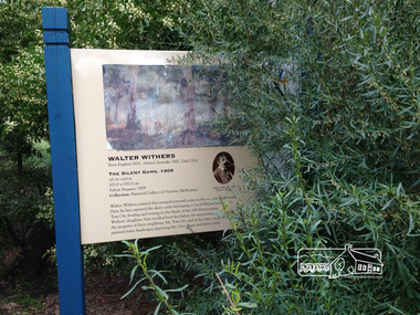
The Heidelberg School Artists Trail was established in about 1999 with about 52 signs across four local governemnt areas including Nillumbik and Banyule. This one located in Wingrove Park Eltham pays tribute to Walter Withers and his painting "The Silent Guns" Transcription of sign: Walter Withers – The Silent Gums, 1909 Walter Withers painted this tranquil pastoral scene in the vicinity this park. Here he has captured the dairy cattle belonging to local Eltham farmer, Mr. Tom Orr, feeding and resting in the shade of the tall Manna gums. Wither’s daughter, Nan recalled how her father, for inspiration, often visited the property of their neighbour, Mr. Tom Orr, and in his later years, Withers painted many landscapes depicting Mr Orr’s sheep and dairy cattle. Heritage Excursion by EDHS Members - An Eltham South Ramble, 2 Sep 2017Born Digitalactivities, eltham district historical society, eltham south, heritage excursion, local history centre, walter withers, heidelberg artists' trail, wingrove park trail, the silent gums -
 Eltham District Historical Society Inc
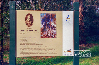
Photograph, Peter Pidgeon, Landscape with sheep by Walter Withers part of the Heidelberg Artist Trail, 2 Sep 2017
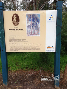
The Heidelberg School Artists Trail was established in about 1999 with about 52 signs across four local governemnt areas including Nillumbik and Banyule. This one acknowledges "Landscape with Sheep" by Walter Withers. The text on the board states: Walter Withers depicts in this work a number of sheep on Mr. Tom Orr’s property. Our view is from the rise above this park, from the Lower Plenty side of the nearby Diamond Creek, looking northwards towards the main Eltham township. The area that is now Wingrove Park, would have been to the right, in the valley below the sheep. The mood of this work is warm and vibrant, with the use of strong blues and pinks, and this stands in marked contrast to the softer, cooler greens used by Walter Withers in his work ‘The Silent Gums’. Heritage Excursion by EDHS members - An Eltham South Ramble, 2 Sep 2017Born Digitalactivities, eltham district historical society, eltham south, heritage excursion, local history centre, eltham, heidelberg artists' trail, walter withers, landscape with sheep, wingrove park trail -
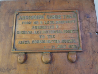 Kiewa Valley Historical Society
Plaque - Aborigine Canoe Tree
Newspaper clipping 11 July 1972. See KVHS 1030 and KVHS 0198The tree was found along the Kiewa River and indicates that Aborigines lived by the river and used tree bark to craft canoes to cross rivers and to fish in the deeper sections of the river.Wooden board with raised letters glued on. Surrounded by a wooden frame with decorated corners. It has 3vwooden footings. some letters have fallen off. See KVHS 1030Message: Aborigine Canoe Tree / From Mr D. Leys Property / Presented By / Kiewa Valley Historical Society / To The / Kiewa Consolidated School. / 11 July 1972canoe tree at kiewa -
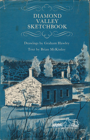 Eltham District Historical Society Inc
Book, Diamond Valley sketchbook / text by Brian McKinlay ; drawings by Graham Hawley, 1973
Contents include short articles and illustrations of historic properties within the municipalities of Banyule, Nillumbik and Whittlesea. Including The Griffin House, Rosehill, Lower Plenty, The Austin Hospital, Heidelberg, St John's Church, Heidelberg, Banyule, Heidelberg, Trestle Bridge, Eltham, Diamond Valley railway, The Shillinglaw Cottage, Eltham, Montsalvat, Old England Hotel, Heidelberg, Eltham Primary School, Mud brick homes, Eltham, Sweeney's Cottage, Eltham, Pound Pend Tunnel, The Gold Memorial, Potter's Cottage, Memorial Tower, Charterisville, Weller's Pub, The Barrel, Eltham, Hassall's Gallery, The Old Bridge, Greensborough, Diamond Valley Shire Offices, Greensborough, St Katherine's Chapel, Yan Yean Reservoir, Mernda Hotel, Mernda Mechanics Institute, Old Barn, Mernda, Parade College, La Trobe University.Hardback with jacket ; 63 p. : ill., maps ; 22cm. diamond valley shire, shire of nillumbik, city of whittlesea, city of banyule, shillinglaw cottage, weller's hotel -
 Warrnambool and District Historical Society Inc.
Documents, Technical Drawings Feed Pump
These drawings have been produced in 1919 by Ron Uebergang when he was a pupil at the Warrnambool Technical School. The Uebergang families were pioneers in the Warrnambool/Allansford area. Ronald Uebergang (1903-1971) was born in Warrnambool to Ernest Uebergang and Mary Watson. He went to Allansford State School and Warrnambool Technical School and married Myra Hall. He was mechanically-minded, a good photographer and fond of music and dancing. He and Myra had a dairy farm at the family property, Hopkins Hill near Allansford and later took up grazing beef cattle. Warrnambool Technical School was established in 1913, and was located first on a Timor Street site and later moved to Caramut Road. Today it is called Brauer College. These drawings are of considerable interest because they were produced by Ron Uebergang and the Uebergang families have been prominent in the history of the Warrnambool and Allansford areas since the 1850s. They are also of interest as examples of the type of work produced by students of Warrnambool Technical School in its early days. .1 A Blueprint for a Feed Pump for a Horizontal Engine - blue background, white drawings. The drawing is two-thirds of the full size object. .2 The same drawing on white see-through paper. The paper has a thick line drawn around the edges in black ink. .3 The same drawing on plain white card with drawings in black ink and a thick line drawn around the edges in black ink. .4 The original brown paper covering used to send the drawings to Warrnambool Technical School in 1921. There are also two pages of handwritten material attached to the drawings by a metal clip and giving a description of the design of the Feed Pump. ‘Warrnambool Technical School’ ‘Designed by R. Uebergang’ ‘Drawn by R. Uebergang’ ‘Date 7/10/19’ ronald uebergang, warrnambool technical school, history of allansford, history of warrnambool -
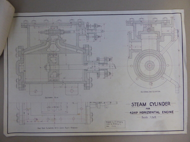 Warrnambool and District Historical Society Inc.
Document, Steam Cylinder Horizontal Engin, 1919
This drawing was produced by Ron Uebergang in 1919 at the Warrnambool Technical School. Members of the Uebergang families have been in the Warrnambool/Allansford area since the early 1850s. Ronald Uebergang (1903-1971) was born in Warrnambool, the son of Ernest Uebergang and Mary Watson. He lived at the family property, Hopkins Hill, and went to Allansford State School and Warrnambool Technical School. He was mechanically-minded, fond of music and dancing and a keen photographer. He married Myra Hall and they ran a dairy farm at Hopkins Hill and later went in for grazing beef cattle. Warrnambool Technical School was established in 1913, firstly at a Timor Street site and later at Caramut Road. Today it is called Brauer College. This drawing is of considerable interest as it was produced by Ron Uebergang. Members of the Uebergang families have been prominent in the Warrnambool/Allansford area since the early days of the district’s establishment. It is also important as a good example of the type of work produced by students from Warrnambool Technical School in its early years. This is a1919 drawing of a Steam Cylinder for a 45 HP Horizontal Engine. The drawing is half the full size of the cylinder. The drawing is on a white card with the sketches done in black and red ink. The card has a heavy black margin around the edges drawn in black ink. The drawing shows a Sectional Plan and a Half Side Elevation with the Cover Plate Removed. The card has the signature of Ron Uebergang. Attached by a metal clip to the card are four pages of measurements and plans of the steam cylinder. These are in black and red ink. Three of these pages have become partly detached. ‘Designed by R. Uebergang’ ‘Drawn by R. Uebergang’ ‘Date 1/12/19’ ronald uebergang, warrnambool technical school, history of allansford, history of warrnambool -
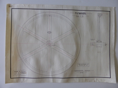 Warrnambool and District Historical Society Inc.
Drawing, Warrnambool Tech .1 Fly Wheel.2 Bevel Wheels R Uebergang, 1919
These drawings have been produced by Ron Uebergang at the Warrnambool Technical School in 1919. Uebergang family members were pioneer settlers in the Warrnambool area in the early 1850s. Ronald John Uebergang (1903-1971) was born in Warrnambool to Ernest Uebergang and Mary Watson. Ron Uebergang lived at the family property, Hopkins Hill at Allansford and went to Allansford State School and Warrnambool Technical School. He was mechanically minded, a good photographer and fond of music and dancing. He married Myra Hall and was a dairy farmer at Hopkins Hill and later grazed beef cattle. Warrnambool Technical School was established in 1913, firstly at a Timor Street site and later at Caramut Road (today it is known as Brauer College). These drawing are of considerable interest as works produced by Ron Uebergang. Uebergang family members have been prominent in the Warrnambool-Allansford area since the pioneering days of the district. The drawings also are good examples of the type of work produced by Warrnambool Technical School students in its early years.These are two designs and drawings by Ron Uebergang produced at the Warrnambool Technical School in 1919. They are drawn on white card using black and red ink. The scale of the Flywheel is three inches to one foot and the Bevel Wheels are one-third full size. The drawings are edged with heavy black lines. The two sheets have the signature of Ron Uebergang. There are also four pages of handwritten notes on the Flywheel and Bevel Wheels.‘Designed by R. Uebergang’ ‘Drawn by R.Uebergang’ ‘Date 4/1/19’ (on Flywheel sheet) ‘Date 27/5/19’ (on Bevel Wheels sheet) warrnambool technical school, ronald uebergang, history of allansford -
 Warrnambool and District Historical Society Inc.
Note Book, Engineering Drawings, 1919-21
This note book contains handwritten material by Ron Uebergang – notes on engineering drawings prepared for a class at Warrnambool Technical School 1919-1921. Ronald Uebergang (1903-1971) was the son of Ernest and Mary Uebergang. He attended Allansford State School and Warrnambool Technical School and spent his working life dairying and raising cattle on the family property, Hopkins Hill, at Allansford, about nine kilometres east of Warrnambool. He was mechanically minded, fond of music and dancing and a keen photographer. These notes are of interest as they were compiled by Ron Uebergang when he was a student at Warrnambool Technical School 1919-21. The Uebergang families were pioneering settlers in the Allansford area and have been prominent farmers in the area from the 1850s on. The notes also are a good example of the work done by students at Warrnambool Technical School in the 1920s. This is a hand-made book of 22 pages with notes on engineering drawings by Ron Uebergang handwritten in black ink. There is tissue paper inserted between some of the pages. There are several drawings and equations in with the handwritten material. There is some silver fish damage on the front cover. Front Cover: ‘R. Uebergang’ ‘Note Book for Engineering Drawing Grade 3’ ronald uebergang, warrnambool technical school, history of allansford, history of warrnambool -
 Warrnambool and District Historical Society Inc.
Book, Third Book, Late 19th century
This little book is very old, presumably 19th century, but the wording on the front cover is indecipherable, no date is evident and the first and last pages are missing. The book was owned by Mary Jane Freckleton with the main inscription written in an adult hand – ‘Mary Jane Frickelton, Mailers Flat’. The spelling of Mailers Flat with an ‘e’ was not a mistake but this was the common spelling in the 19th century and the early 20th century. According to the Freckleton family history ‘Freckleton’ was sometimes spelled ‘Frickelton’ or ‘Frickleton’. Mailors Flat is nine kilometres from Warrnambool and the Mailors Flat School, number 1210, was opened in 1872 in Caramut Road and closed in 1994. The first Head Teacher was Julian Castles. There were Freckelton families in the 19th century in Port Fairy, Caramut, Woolsthorpe, Woodford and Mailors Flat. The Freckletons at Mailors Flat were engaged in farming. Mary Jane Freckleton was for a time a pupil teacher at Mailors Flat School. She was born at the Injemira property and married Henry Giles. This is an interesting book because of its age and because it belonged to Mary Jane Freckleton, a member of the Freckleton families, early settlers in the areas north of Warrnambool. She may have used the book when she was a pupil teacher at the Mailors Flat School. This is a hard cover book of 284 pages (some pages missing). The cloth cover is brown and much torn and stained. There are 86 chapters of prose and verse and a sprig of dried flowers is enclosed in the pages. There is the red stamp of the Warrnambool & District Historical Society on the first page and several snippets of writing in black ink on the front and back pages.‘Mary Jane Frickelton Mailers Flat’mary jane freckleton, mailors flat school -
 Warrnambool and District Historical Society Inc.
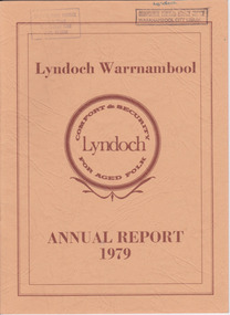
Document - Lyndoch Warrnambool 1979 Annual Report, 1979
This is the 1979 Annual Report for Lyndoch Home and Hospital for the Aged, Warrnambool. It contains lists of Board Members, a President’s Report, a sketch of a proposed new building, financial reports, photographs and a list of Life Governors. Lyndoch Home for the Aged was established in 1952 and has developed with a wide range of facilities for the aged since that date. The original Lyndoch property near the mouth of the river Hopkins was owned by a Melbourne tea merchant, George Rolfe, who bought the land when there were only on the site a couple of cottages and a larger building which had been a school, Warrnambool Grammar, run by Henry Kemmis. Rolfe acquired the land in the 1870s and named the property Lyndoch after the town in the Barossa Valley where he had lived. He owned Lyndoch for 44 years and it was his stepdaughter, Florence Lake who built in the 1920s the bungalow known as Lyndoch which forms the original building of the Lyndoch Home for the Aged. Today the facility is called Lyndoch Living.This report is kept for the benefit of researchers wanting details of the history of Lyndoch over the past thirty or forty years.This is a booklet with a cardboard buff-coloured cover. There are six double-sided pages with printed material on white paper with a yellow and orange stripe across the top of the pages.On front cover: Lyndoch Warrnambool, Annual Report 1979 In brown circle on front cover: Lyndoch, Comfort and Security for Aged Folk Two library stamps on front cover (Warrnambool Library) lyndoch, aged care facility, warrnambool, hopkins, warrnambool grammar -
 Warrnambool and District Historical Society Inc.
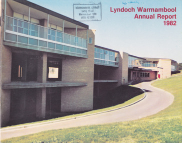
Document - Lyndoch Warrnambool 1982 Annual Report
This is the 1982 Annual Report for Lyndoch Home and Hospital for the Aged, Warrnambool. It contains lists of Board Members, a President’s Report, Lyndoch’s Aims, financial reports, photographs and a list of Life Governors. Lyndoch Home for the Aged was established in 1952 and has developed with a wide range of facilities for the aged since that date. The original Lyndoch property near the mouth of the Hopkins River was owned by a Melbourne tea merchant, George Rolfe, who bought the land when there were on the site only a couple of cottages and a larger building which had been a school, Warrnambool Grammar, run by Henry Kemmis. Rolfe acquired the land in the 1870s and named the property Lyndoch after the town in the Barossa Valley where he had lived. He owned Lyndoch for 44 years and it was his stepdaughter, Florence Lake who built in the 1920s the bungalow known as Lyndoch which forms the original building of the Lyndoch Home for the Aged, Today the facility is called Lyndoch Living. This 1982 report is kept for the benefit of researchers wanting details of the history of Lyndoch over the past 30 or 40 years. This is a booklet with a plasticized cover with a white back and a multi-coloured front cover. The front cover has a photograph of a Lyndoch building. There are six double-sided pages with printed material and photographs on white paper and a yellow and orange strip across the top of the pages. The pages are stapled.On front cover: Lyndoch Warrnambool Annual Report 1982 Stamp of Warrnambool Library On back cover: A red circle with the words ‘Lyndoch, Comfort and Security for Aged Folk’ lyndoch aged care facility, warrnambool, lyndoch warrnambool -
 Warrnambool and District Historical Society Inc.
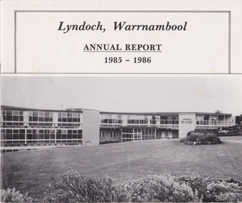
Document - Lyndoch Warrnambool Annual Report 1985-86, 1986
This is the 1985-6 Annual Report for Lyndoch Home and Hospital for the Aged, Warrnambool. It contains lists of Board Members, a President’s Report, photographs, Lyndoch’s Aims, financial reports and a list of Life Governors. Lyndoch Home for the Aged was established in 1952 and has developed with a wide range of facilities for the aged since that date. The original Lyndoch property near the mouth of the River Hopkins was owned by a Melbourne tea merchant, George Rolfe, who bought the land when there were on the site only a couple of cottages and a larger building which had been a school, Warrnambool Grammar, run by Henry Kemmis. Rolfe acquired the land in the 1870s and named the property Lyndoch after the town in the Barossa Valley where he had lived. He owned Lyndoch for 44 years ad it was his stepdaughter Florence Lake who built in the 1920s the bungalow known as Lyndoch which forms the original building of Lyndoch Home for the Aged. Today the facility is called Lyndoch Living. This 1985-6 report is kept for the benefit of researchers wanting details of the history of Lyndoch over the past 30 or 40 years.This is a booklet with a plasticized white cover with a black and white photograph of a Lyndoch building on the front cover. There are eight double-sided pages with printed material and photographs. The pages are stapled.On front cover: ‘Lyndoch, Warrnambool, Annual Report, 1985-1986 On back cover: A black circle with the words: ‘Lyndoch, Comfort and Security for Aged Folk’. lyndoch aged care facility, warrnambool -
 Eltham District Historical Society Inc
Photograph, Henley Bridge, Spring Excursion, Exploring the Upper Yarra, 22 October 1995, 22/10/1995
[article by Bettina Woodburn in EDHS Newsletter No. 105, November 1995:] EXPLORING THE UPPER YARRA - We enjoyed the Spring Excursion, this year "Exploring the Upper Yarra" - in spite of the constant rain and the countryside under the cloud cover, especially in the valleys, being mainly shiny shades of green. The occasional fields of buttercups, clumps of arum lilies and splendid rhododendron and other flowering bushes became very special. The Cobb and Co coach was warm and a cosy retreat as we zig-zagged on the highways and byways to glimpse the Yarra River, upstream and down, its secret places, and particularly the many bridges. Russell excelled as 'Poet Laureate', reading from Dacre Smyth's book. This 1979 publication includes paintings of all the bridges along the river with poems and brief descriptions of each one. Some of the bridges are in out-of-the-way places and are not very well known. We looked forward to hearing the poetry as much as seeing the 'constructions'… Big Pat (was he short or tall, lean or fat? - he did win the £200 reward for discovering gold and had the creek named after him), about the 'Eddies'?, and the disliked 'meccano' bridge in Warburton, etc. etc. The hot roast lunch in the old Reefton Hotel was also most welcome. It was easy to imagine it peopled by miners and early settlers. Starting by crossing the new (1974) concrete bridge at Warrandyte we headed through Wonga Park with views to the Christmas Hills and to the escarpment of the Yering Gorge, which causes flood waters to back up through the Yarra Glen plain, so avoiding disasters downstream. At the end of a long driveway we found the wooden, privately owned Henley Bridge (1935 after the 1934 floods). This facilitates access to different parts of Henley Farm and to Lilydale. Everard Park, named after Blanche Shallard's father, a State Member for 17 years, below the Highway Yarra crossing was in need of care. It is 10 miles from Yarra Glen by road but, as "Yarra Marra” canoeists well know, 32 winding miles down by water. After more delightful countryside scenes we joined the Warburton Highway at Woori Yallock. From the old Railway Station at Launching Place the Centennial Trail for walkers, cyclists and horse riders has replaced the rails. The line from Lilydale was opened in 1901, and the last diesel freight train ran to Warburton in 1965. It continued to rain as we had morning tea in Warburton in a shelter between footbridges. From here we continued upstream past the Bridge to O'Shannassy Lodge and Reservoir, Starvation Creek, and the Peninsular tunnel (miners dug it as at Pound Bend) which we visited (scrambling down those steps!) on our return after lunch. Our furthermost point was the Upper Yarra Dam Reserve (and vast catchment area). Finished in 1957 after ten years' work and 100 years after Yan Yean, it supplies much of Melbourne's water. After crossing the 30m Launching Place Bridge to the Eltham side of the Yarra and Healesville, we saw in the distance the Yarra Glen Timber Trestle Bridge over the river flats "the longest for years in the land it was said!" Harry's dream of "better weather over the Divide" unfortunately didn't come true, but I'm sure we 36 members will retain happy memories of a day that was wet and green and filled with Bridges. Situated on the Yarra River, 5.5 kms south of Christmas Hills on private property. This timber trestle bridge is said to have been built some time after 1907 by Melbourne master-builder, David Mitchell (the father of Dame Nellie Melba), to connect his two "Henley Farm" properties with Lilydale. In earlier days, when the McPhersons owned the property, their children used a punt to cross the river to attend Yering Primary School. This private bridge is best viewed from the end of Wendy Way. - Source: Christmas Hills Past and Present, Yarra Glen & District Historical Society, 2004.Two colour photographsactivities, henley bridge, upper yarra -
 Ringwood and District Historical Society
Book - Eureka Plan, Farmer, Mr, Eureka Plan, c. 1930
Created to assist in promotion and sale of land near Ringwood Railway station, following completion of the electric rail to Ringwood..Book containing details of seven delightful and valuable Ringwood properties - Bestpart, Paradur, Hill Top, Greenwood, Creek, Station and School estates. The book has 16 photos and 20 plans and 20 pages. There are multiple copies of pages 20x2; 19x2; 18x4; 17x4 and 20x2. +Additional Keywords: Farmer, Mr -
 Ringwood and District Historical Society
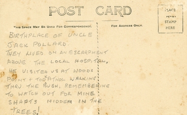
Photographs, Collection of Pollard Photographs, Ringwood (Undated -probably early 1900's). Also Woods Point 1900, circa 1900
Pollard Photographs:; 1. Back of postcard of the Pollard home in Wonga Road (also called Anderson Creek Road Road, and now Warrandyte Road).; 2. One bushel net apples, J Pollard, Victoria, Australia.; 3. Joseph and Emma Pollard and Family. Emma is nursing baby Ethyl.; 4. Ringwood PS photograph. Jack Pollard is second from the RHS in the back row.; 5. Woods Point with arrow indicating mine manager's house: that of Joseph Pollard. Circa 1900. The Pollard family had a 20 acre orcharding property between Mullum Mullum Road and Wonga Road. Given on 4th September 2010 by Arthur Lunt from his cousin. The Pollard family. School photo at Ringwood State School. Jack�s father was Joseph � land (orchard) between Mullum and Wonga Roads +Additional Keywords: Pollard -
 Australian Commando Association - Victoria
Metal Uniform Embellishments of the Australian Army Post 1953 Volume 1 - Insignia for Corps and Schools, 2017
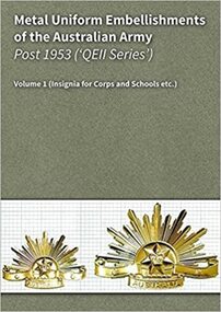
This 236 page, full-colour hard copy reference work, catalogues the metal insignia embellishments used by all Corps and Schools of the Australian Army (including philanthropic organisations), from 1953 through to the present. The book provides images of the front and the back of a given (metal) insignia set for each Corps etc. Each image set depicts the relevant hat badge, collar badges and epaulette title and/or cloth shoulder title applicable. The book's images record three distinctly different 'generations' of insignia manufacturing methods/types, including the: gilt brass and white metal items used in the 1953 to 1964 period; and anodised aluminium 'StayBright' insignia introduced as from 1964[ and 'BriteShine' insignia introduced with effect from 1997 (running through to the present). The full colour photographic images in the book are complimented by written descriptions which cite each item's distinguishing characteristics... including measures of: typical weight, height, width and thickness (at a given point). A discussion of copies and faked items is also provided, including microscope resolution images of 'tell tale' signs to look for. The entries in the book are organised alphabetically and match those used in the Authors' 614 page eBook version of this work (the eBook is a separate edition which provides scalable images of all relevant insignia and many manufacturing variants).The hard copy and electronic editions of this work are able to be used either separately or concurrently, as and when users require. Regards Mark Corcoran & Arthur Butler The Authors charlibravobooks.com Re: Copyright As the original authors we hold the sole copyright authority to sell this work. This item does not infringe on any copyright, trademark and/or intellectual property rights and we hold specific written publication approval from the Australian Defence Force. Soft cover, spiral bound 235 pagesaustralian army, post ww2 insignia -
 Ringwood and District Historical Society
Plan, Ringwood Station Estate, Subdivision, Ringwood, Victoria - circa 1925
ID 5224 note: Further information relating to squares marked H, F, G, J, and K included in ID 5225 - Ringwood Shop and Dwelling Estate.Hand drawn plan of Ringwood Station Estate showing allotments for sale, with two typed pages attached showing land title information and sale prices.Drawn by Edyth Greenwood, phone 988 Central. Subdivision includes Station Street, Pitt Street, Bedford Road, Wantirna Road, James Street, William Street (later Kendall Street), Greenwood Avenue, Ellison Street, and Haig Street. Circles denote blocks for sale. Squares denote house properties for sale. Other features marked include location of businesses along Main Street (Maroondah Highway), cool store, railway station, shop and police station on Bedford Road, church on Station Street, site of schoolmaster's residence and State School, and location of proposed public baths. Ryner & Langford, Solicitors -
 Ringwood and District Historical Society
Letter, Property for sale - Ringwood Shop and Dwelling Estate, Ringwood, Victoria - circa 1925
ID 5225 note: Further information relating to allotments marked on the hand-drawn plan are included in ID 5224 - Ringwood Station Estate.Typewritten letter from A.V. Greenwood with hand drawn plan of Ringwood Shop and Dwelling Estate, detailed description of property for sale, and top and side elevation views of house. (7 pages)(Transcript of first page - to unknown recipient) Phone 988 Central, 331 Canty Greenwood Pty. Ltd. 5 Flinders Street Melbourne. Dear Sir, 1. Attached please find drawings of my house at Ringwood. 2. It is for sale at £4,865 or to let at £5 per week to an approved tenant. 3. I sold it to Mr. De Garis and vacated it, but it is now back on my hands. 4. I leased another place instead of living in my own. I may be able to cancel same; in the meantime, however, I propose to sell or let my own. The painters are now going through the place; re-varnishing, re-oiling and re-polishing so that in about five days it will look "spick and span". 5. The house was specially built under my own supervision. 6. It is very suitable for a high class Guest House, Doctor's residence, Hospital or Convalescent Home. If you know of anyone whom it might suit, please communicate with them. DESCRIPTION 7. It stands on 305 feet of land facing Greenwood Avenue. It is cement, roughcast and hardwood, well oiled, and is now being redone so that the house is as good as new; red tile roof; verandahs three sides; two sleep-outs; five bedrooms; large dining room; very large music room with nooks, upstairs lounge, study; sewing room; built-in wardrobes and cupboards throughout; handsome kitchen with handsome pantry cupboard with drawers and glass front; one bath room; one shower room; wash house with patent copper and laundry. Every modern convenience, hot water system (through copper pipes with large copper cylinder) electric lights everywhere, outside and in, Yan Yean water laid on everwhere throughout house and gardens. Floors throughout are the very best, close set, stained and polished; dainty lead light windows etc. 8. There is a big garage, with tiled roof and two rooms with all conveniences for a married couple. Property is well drained with a system of its own. The house stands upon the top of a hill close to Railway Station, say 500 feet from the Footbridge. 9. The garden has expansive shrubs; sheds; fernery; tennis court. 10. A handsome piece of furniture goes with the house; a combination pantry and storeroom for groceries, milk, bread etc., consisting of drawers, glass and wire doors, as mentioned above. 11. It is within easy distance of Melbourne as it is only two minutes from Ringwood Station, which is a frequent electric train service bringing it within 39 minutes of the City. It is thought better by some to go further out into the country atmosphere and walk a short distance at the end than to go by train 20 minutes then walk 15 to 20 minutes. 12. The price quoted of £4,865 is made up as follows - 305 feet of land @ £5 ... £1,515 Garage and dwelling ... £300 House hot water system, American cupboard ... £2,600 Water, fencing, sheds & drain ... £250 For the lot ... £4,865 Should you require copies of the enclosed drawings I shall be pleased to supply same. 13. Mr. J.B. McAlpin is the local agent, Phone Ring. 7 (after hours Ring. 44) or you may phone me Central 988. 14. The house is south of the line, facing Greenwood Avenue and immediately at the back of Ringwood House, which is also my property. Yours sincerely, A.V. Greenwood (illegible) ..... (Transcript of second page) RINGWOOD SHOP AND DWELLING ESTATE See these letters on plan attached (H.) Ringwood House and Shops on 100 by 150 feet of land fronting Bedford Road 100 feet @ £10 per foot - £1,000 House and shops - £2,400 ... £3,400 Ringwood House consists of Boarding House, (Phone 101) and two shops, mainly brick; 9 inch walls. Will carry another story. Has music room, dining room, entrance halls, 10 bedrooms, large verandahs, all conveniences, hot and cold water, and stands on what will become a most valuable business corner. (F.)(G.) Mr. Greenwood's house, garage and sheds, stands on 307 feet of land fronting Greenwood Avenue. See detailed description attached ... £4,865 (J.) Cottage on Block 81 in William Street ... £750 (K.) Cottage in Pitt Street ... £650 (Total) £9,665 ..... (Description of third page - Subdivision Plan) Drawn by Edyth Greenwood, phone 988 Central. Subdivision includes Station Street, Pitt Street, Bedford Road, Wantirna Road, James Street, William Street (later Kendall Street), Greenwood Avenue, Ellison Street, and Haig Street. Circles denote blocks for sale. Squares denote house properties for sale. Other features marked include location of businesses along Main Street (Maroondah Highway), cool store, railway station, shop and police station on Bedford Road, church on Station Street, site of schoolmaster's residence and State School, and location of proposed public baths -
 Ringwood and District Historical Society
Flyer, Stillwell & Stephens Pty. Ltd, Brochure - Multiple Properties for Public Auction at Box Hill, Ringwood, Wonga Park and Clarinda - 28th November, 1934
Seven-page brochure advertising Mortgagees' Realising Sale by Public Auction on Wednesday, 28th November, 1934 for properties at Box Hill, Ringwood, Wonga Park, and Clarinda (via Oakleigh), including photographs, property descriptions, and terms of sale.Auction Commencing at 2.15 p.m. in the Orient Line Auction Rooms, 352 Collins Street, Melbourne. Solicitors: Messrs. Madden, Butler, Elder & Graham, 406 Collins Street, Melbourne. (Agents) H.P. Knight & Co. Property Salesmen and Subidivisional Experts, 315 Collins Street, Melbourne, 'Phones: Central 10615, 10616. Attractive Residential, Orchard, and Market Garden Properties, and Public Hall and School Rooms. 1. Wonga Park via Ringwood - "Holme Bush" off Warrandyte Road, Part of Lots 14 and 15, Ringwood Orchard Estate, approximatgely three miles (north) of Ringwood Railway Station - 64 Acres. 2. 17 Bishop Street, Box Hill - timber residence. 3. Greenwood Avenue, Ringwood - On East Side, 150 feet 3 inches South of Bedford Road - timber attic residence. 4. Ringwood - Wantirna Road, South-east corner of Canterbury Road - Orchard Property of approx. 11-1/2 Acres. 5. Box Hill - Whitehorse Road, South-east corner of Linsley Street - Timber building utilised as a Public Hall and Private School. 6. Clarinda vic Oakleigh, Talbot Crescent, off Centre Road - Home on 10 acres of land. -
 Ringwood and District Historical Society
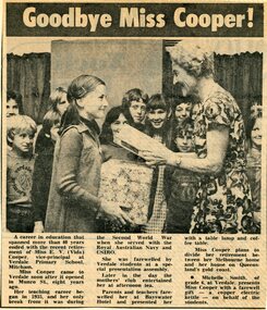
Memorabilia - Newspaper clippings, Miss E.V. (Vida) Cooper retirement - Teaching career included Mitcham and East Ringwood Primary Schools, Victoria
Vida Cooper's first teaching post was Ringwood East Primary School, Everard Road. Clippings included with Cooper Collection memorabilia donated by Annette Rattray - a distant relative.Newspaper clipping circa 1975 headed Goodbye Miss Cooper and 1942 clipping of cattleyard scene.1. Michelle Smith of grade 6 at Verdale Primary School, Mitcham, presents Miss Cooper with a farewell gift - a copper electric kettle - on behalf of the students. 2. Wednesday, March 11, 1942 - Helping with the branding: Two city girls helping with the branding on Mr. John Roper's property, Mt. Yorke, Tawonga, via Wodonga. -
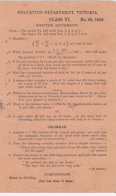 Cheese World Museum
Document, School test -arithemetic Grade VI
The Uebergang family came from Silesia to Australia in 1848 and were early settlers in the Allansford area. The sons and other descendants also purchased farms in the area. The Percy Uebergang family lived at Tooram Park, Allansford from 1912 until 1992. Percy and Myrtle Uebergang's children were twins, Ray and Joyce born in 1926 who lived at Tooram Park until their deaths, Ray in 1986 and Joyce in 1992 after which the property was sold. Neither Ray nor Joyce married and following the death of her brother Joyce set up the Ray and Joyce Uebergang Foundation which supports the local community. The collection of items from their property was put into store for a number of years before being given into the care of the Cheese World Museum. The family often re-used, recycled and repaired items and examples can be seen in the museum. This item is part of the collection of items given into the care of the Cheese World Museum. The Victorian Education Department compiled set tests for schools. This test aimed at Year 6 students dates from 1904 and includes some complex written arithmetic problems, grammar analysis and an essay on 'Clothing'. This test sheet is significant as an example of the level expected of Class VI students in 1904.A single page printed in black ink on dull orange coloured paper with tests arithmetic, grammar and composition for Class VI, No.65, 1904 composed by the Education Department, Victoria.EDUCATION DEPARTMENT, VICTORIA/CLASS VI/No.65, 1904/WRITTEN ARITHMETIC/ … /GRAMMAR/…/COMPOSITIONallansford, grammar, school tests, arithmetic, composition, education department victoria, education, schools -
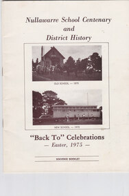 Cheese World Museum
Book, Nullawarre School Centenary and District History, 1975
LeThe Uebergang family came from Silesia to Australia in 1848 and were early settlers in the Allansford area. The sons and other descendants also purchased farms in the area. The Percy Uebergang family lived at Tooram Park, Allansford from 1912 until 1992. Percy and Myrtle Uebergang's children were twins, Ray and Joyce born in 1926 who lived at Tooram Park until their deaths, Ray in 1986 and Joyce in 1992 after which the property was sold. Neither Ray nor Joyce married and following the death of her brother Joyce set up the Ray and Joyce Uebergang Foundation which supports the local community. The collection of items from their property was put into store for a number of years before being given into the care of the Cheese World Museum. The family often re-used, recycled and repaired items and examples can be seen in the museum. This item is part of the collection of items given into the care of the Cheese World Museum. Nullawarre State School No.1652 opened in 1875 on a site donated by George Henry. The weatherboard school was 27ft by 18ft. Margaret Mathieson was the first of the 17 pupils registered. The first head teacher was Charles A Bruford. The first building was replaced with a new building by 1975 when the celebrations took place. A brief history of Nullawarre township and some of its early residents is also included. Early families include Mathieson, Burleigh, LeCouteur, Wallace and Hesketh. A photograph of the Nirranda and District WWI Honor Roll details those from the Nullawarre area who served. Today the school has been enlarged and is now Nullawarre and District Primary School.This booklet is significant as it provides a history of Nullawarre school and an overview of the Nullawarre district and some of its early residents. A cream coloured booklet with sepia coloured text and photographs of the school.Nullawarre School Centenary/and/District History/OLD SCHOOL-1975/NEW SCHOOL-1975/"BackTo" Celebrations/-Easter 1975-/SOUVENIR BOOKLETallansford, nullawarre, uebergang, schools, henry, bruford, mathieson, burleigh, lecouteur, wallace, hesketh, nullawarre state school -
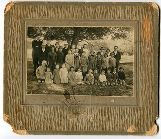 Orbost & District Historical Society
Photograph - Jarrahmond School & pupils c.1914
The Jarrahmond State School No. 2745 near Orbost was one of the earliest in this district. It opened in 1886 at the same time as Orbost and shared a teacher (Campbell McKay who was shortly afterwards replaced by John Rowe who stayed in this position until 1908). The building was financed and built by local farmers on the Stapley property. After a large and damaging flood in the nearby Snowy River in 1893 , the building was shifted to a new location. In 1926, a new building was constructed by the Vic Ed Dept. where it remained until the school was closed in 1948 and children from the Jarrahmond area were then bused to Orbost. Historical significance as one of the earliest photos of Jarrahmond School students.A b/w photo of a group of children and one adult in front of a tree. Children in the front are sitting on the ground, others are standing behind. Photo is mounted onto brown cardboard. On back of photo: Jarrahmond School c.1914. Sally Cole, Angus Cole.education, jarrahmond school, orbost -
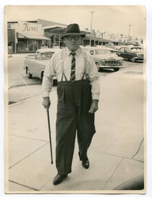 Orbost & District Historical Society
Photograph - Photograph off Albert Trewin
Albert (Abby) Trewin (b.21.03.1876 d. 01.07.1970) was part of the Trewin family who were early settlers at Jarrahmond near Orbost. Albert was born at Kingston near Ballarat, shifted to Jarrahmond where the house was called "Hillview", located 3 miles from Orbost on the B Road. The Trewin selection at Jarrahmond had many big trees on it and because these looked a bit like Jarrah trees from Western Australia, they names their property Jarrahmond (which became the district location and the name of Jarrahmond School). He cleared the land with bullocks, horses, crosscut saws, burned the stumps, burying some logs which were too big to burn. Then they milked cows, planted maize, had pigs, drove the pigs to Bairnsdale or to Waygara (c. 1915 when the train reached Waygara) on a buggy track through the bush. Pigs went to Dandenong Bacon Factory where they were processed into Dandy Ham. This photograph appears to be c.1950s - 1960s.A photograph of one of Jarrahmond's earliest settlers.B/W photograph of a man walking along a footpath. He is wearing a hat and has a walking stick in his right hand. He is wearing braces, white long-sleeved shirt, striped tie, glasses, polished black shoes. Behind him are vehicles and buildings (shops). jarrahmond, farming -
 Eltham District Historical Society Inc
Photograph, Heidelberg Artists Trail sign, "Landscape with Sheep" Walter Withers, Wingrove Park, Eltham, c.May 2001
The Heidelberg School Artists Trail was established in about 1999 with about 52 signs across four local governemnt areas including Nillumbik and Banyule. This one acknowledges "Landscape with Sheep" by Walter Withers. The text on the board states: Walter Withers depicts in this work a number of sheep on Mr. Tom Orr’s property. Our view is from the rise above this park, from the Lower Plenty side of the nearby Diamond Creek, looking northwards towards the main Eltham township. The area that is now Wingrove Park, would have been to the right, in the valley below the sheep. The mood of this work is warm and vibrant, with the use of strong blues and pinks, and this stands in marked contrast to the softer, cooler greens used by Walter Withers in his work ‘The Silent Gums’.Roll of 35mm colour negative film, 7 stripsAgfa HDC 200 plus-2eltham, heidelberg artists' trail, wingrove park trail, landscape with sheep, walter withers -
 Glen Eira Historical Society
Album - Album page, Glenfern, Inkerman Street, Circa 1972
This photograph is part of the Caulfield Historical Album 1972. This album was created in approximately 1972 as part of a project by the Caulfield Historical Society to assist in identifying buildings worthy of preservation. The album is related to a Survey the Caulfield Historical Society developed in collaboration with the National Trust of Australia (Victoria) and Caulfield City Council to identify historic buildings within the City of Caulfield that warranted the protection of a National Trust Classification. Principal photographer thought to be Trevor Hart, member of Caulfield Historical Society. Most photographs were taken between 1966-1972 with a small number of photographs being older and from unknown sources. All photographs are black and white except where stated, with 386 photographs over 198 pages.From Victorian Heritage Database citation for Glernfern H0136 https://vhd.heritagecouncil.vic.gov.au/places/57 (as at 23/10/2020) Glenfern was built on spacious grounds at the corner of Inkerman and Hotham Streets, East St Kilda in two main stages in 1857 and 1876. From 1876 to 1984 Glenfern had only two owners, including the well known Melbourne family of artists, the Boyds. The property was bequeathed to the National Trust of Australia (Victoria) in 1984 and has remained in their ownership. The original Glenfern allotment was bought by John Bakewell in 1856 and sold the following year to Francis McDonnell, a prominent Melbourne investor. By 1858, the house, rated as the most valuable in Caulfield, had been built on the site. Due to financial difficulties, McDonnell offered a number of properties for sale in 1860, including Glenfern. It was not sold at this stage, but subsequently mortgaged in 1862. In 1866 Thomas Watson purchased the property and lived there until 1876 when it was sold to Captain John T. T. Boyd and his wife, Lucy, founders of the Boyd dynasty of artists, musicians, writers and architects. The Boyd family, including twelve children, lived there until 1907, with Lucy Boyd retaining ownership after her husband's death in 1891. In 1907 the property was subdivided and the greatly reduced Glenfern portion was purchased by the Ostberg family, who lived there from 1915. In the latter years of Boyd family ownership and the Ostberg ownership, Glenfern had several tenants and was run as a school on two occasions. The Ostberg family occupancy continued until the death of Miss Amy Ostberg in 1984. From 1929 the property was listed as Glenfern Flats, necessitating various internal alterations over a period of time. The original two storey house, attributed to architect Charles Laing, was extended for the Boyd family in 1876, by architect M. Hennessy. This comprised the addition of a two storey wing to the south of the existing building. Stables were built in 1884 by the architects Smith and Johnson and other outbuildings, since removed, were recorded on the site. The gardens were developed from the establishment of the estate and remnants of early plantings, exotic trees in particular, are evident. Various additions and alterations were made to the house in the twentieth century and a separate block of flats was built on the southern boundary in c1964. Glenfern is a two storey picturesque Gothic house of stuccoed brick with steep, gabled slate roofs, elaborate bargeboards and chimneys of conjoined stacks set diagonally. The original, asymmetrically planned L-shaped house, containing the principal rooms and a rear wing, was designed with two main facades facing north and west. The north facade contains an unusual recessed pointed arch bay formed between twin chimney flues. Internally cedar joinery includes an unusual set of double doors between the drawing room and parlour, the centre pair of which fold back and then slide into the walls. Detailing of the 1876 additions copied that of the original house, including the bargeboards, chimneys and western verandah. Ownership of Glenfern passed to the National Trust of Australia (Victoria) in 1984 and in 2002 transformation of the property into a Centre for the Arts and Culture commenced. This began with the establishment of an Artist-in-residence programme, followed by the Glenfern Writers Centre. Restoration and renovation of the building has been undertaken concurrently with the establishment of this centre. How is it significant? Glenfern, East St Kilda is of architectural and historical significance to the State of Victoria. Why is it significant? Glenfern is of architectural significance as an unusually intact and rare example of the picturesque domestic Gothic Revival house in Victoria. Of particular note are the clustered chimneys, bargeboards and twin arched chimney flues and the folding/sliding cedar doors between the principal rooms. It is significant as an important work of the prominent Melbourne architect, Charles Laing. Glenfern is of historical significance for its connection with the distinguished Victorian Boyd family. It has been recorded in a painting by Emma Boyd, wife of Arthur, in 1885 and in print by writer, Martin Boyd in 1952. Glenfern is of historical significance due to its ownership by only two families from 1876; firstly the Boyds until 1907 and the Ostbergs until 1984. Of note is the resistance to redevelopment in the latter half of the twentieth century and the subsequent survival of the 1907 Glenfern estate.Page 98 of Photograph Album with two photographs (one square and one landscape) of views of Glenfern.Handwritten: "Glenfern" 417 Inkerman Street [top right] / 98 [bottom right]trevor hart, east st kilda, garden, pitched roof, glenfern, hotham street, boyd family, 1850's, 1860's, 1870's, john bakewell, francis mcdonnell, thomas watson, lucy boyd, glenfern flats, charles laing, m. hennessy, smith and johnson, stables, gothic, stuccoed brick, gabled slate roofs, elaborate bargeboards, asymmetrical, cedar joinery, verandah, national trust of australia, centre for the arts and culture, artist-in-residence, glenfern writers centre, gothic revival, clustered chimneys, emma boyd, inkerman street, north caulfield, captain john boyd, artists, writers, st kilda east, national trust of australia (victoria), caulfield, amy ostberg, architects, m hennessy, doors, chimneys, martin boyd, arthur boyd, ostberg family -
 Glen Eira Historical Society
Album - Album page, St Joseph's Presbytery, Orrong Road, Circa 1972
This photograph is part of the Caulfield Historical Album 1972. This album was created in approximately 1972 as part of a project by the Caulfield Historical Society to assist in identifying buildings worthy of preservation. The album is related to a Survey the Caulfield Historical Society developed in collaboration with the National Trust of Australia (Victoria) and Caulfield City Council to identify historic buildings within the City of Caulfield that warranted the protection of a National Trust Classification. Principal photographer thought to be Trevor Hart, member of Caulfield Historical Society. Most photographs were taken between 1966-1972 with a small number of photographs being older and from unknown sources. All photographs are black and white except where stated, with 386 photographs over 198 pages. St Joseph's buildings and grounds are contributory properties to HO72 Elsternwick Estate and environs - City of Glen Eira.Page 162 - two photographs of St Joseph's Presbytery, Orrong Road.Handwritten: St Joseph's Presbytery Orrong Road [top right] / PREVIOUSLY "THE EMS" 1908 [under left photo] / 162 [bottom right]trevor hart, orrong road, curved windows, decorative brackets, arched windows, bay window, portico, slate roof, st joseph's presbytery, catholic church, st joseph's church, st joseph's primary school, porte cochere, the ems, elsternwick, rendered walls, clergy residences, drives, late victorian style, house names -
 Glen Eira Historical Society
Album - Album page, Cromarty, Sandham Street, Circa 1972
This photograph is part of the Caulfield Historical Album 1972. This album was created as part of a project from approximately 1966-1972 by the Caulfield Historical Society to assist in identifying buildings worthy of preservation. This album is related to a Survey the Caulfield Historical Society developed in collaboration with the National Trust of Australia Victoria and Caulfield City Council to identify historic buildings within the City of Caulfield that warranted the protection of a National Trust Classification. Photographers Jenny O’Donnell and Trevor Hart, members of Caulfield Historical Society. Some photographs are older and from unknown sources. All photographs are black and white except where stated. From Victorian Heritage Database citation for HO61 Presentation Convent, 28 Sandham Street Elsternwick https://vhd.heritagecouncil.vic.gov.au/places/35476 (as at 1/11/2020) The "Presentation Convent" is locally significant as a substantial late Victorian villa residence in Elsternwick and for its more recent role in the educational and spiritual lives of the community. https://vhd.heritagecouncil.vic.gov.au/places/65716 (as at 21/08/2021) National Trust Property No B2713 Typical of period but yet interesting for association with Horatio Beauchamp. Classified 26/11/1970 Victorian Heritage Database citation for HO61 Presentation Convent, 28 Sandham Street Elsternwick https://vhd.heritagecouncil.vic.gov.au/places/35476 A substantial two storeyed stuccoed asymmetrical Italianate villa residence, representative of its period, with two storeyed cast iron verandah and projecting facetted bay with trabeated treatment to the ground floor and round arched upper level windows with distinctive moulds.Page 185 of Photograph Album with one photograph of Cromarty.Handwritten: SANDHAM STREET [top] / CROMARTY - OLD CLASSROOMS [under photo] / 185 [bottom left]trevor hart, chimneys, porch, cast iron lacework, school, education, presentation sisters, catholic girls college, balcony, verandah, presentation convent, sandham street, victorian villa residence, villa residence, cast iron frieze, cast iron columns, protruding bay, bay window, 1880's, double storey, cromarty, chiselhurst, chisel hurst, horatio beauchamp, elsternwick, classrooms, class rooms, late victorian style, arched windows