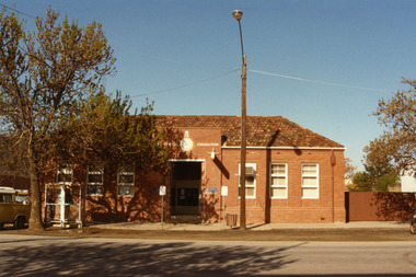
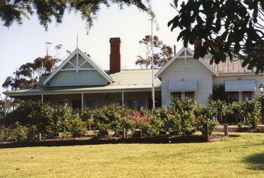
Showing 3899 items matching "bricker"
-
 Bendigo Historical Society Inc.
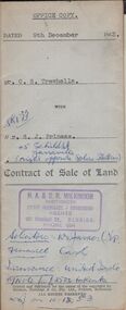
Document - H.A. & S.R. WILKINSON COLLECTION: CONDITION OF SALE
Contract of sale of land dated 9th December 1953 between Mr. C.S. Trewhella (seller) and Mr. S.J. Prineas (buyer) for land being part of Crown allotment 5 section 32 borough of Eaglehawk described in Certificate of title volume 7060 folio 912 and situate 1 Richards Street Eaglehawk, together with brick veneer dwelling and all sundry. Price 3,450 pounds.organization, business, h.a. & s.r wilkinson real estate -
 Bendigo Historical Society Inc.
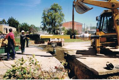
Photograph - CASTLEMAINE GAS COMPANY COLLECTION: PHOTO EXCAVATION
Pipe being laid in trench, 3 workers handling the pipe another one on a bobcat and one on an excavator, man in red shirt standing next to a generator on a trailer, Centre is a hand activated compactor, behind which is the bobcat, left background is cream coloured building, Tree at rear of bobcat, Red brick building to right of centre, right front corner is welding eye shield on the ground.Kodakorganisation, industry, gas and fuel -
 Bendigo Historical Society Inc.
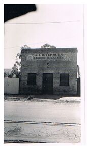
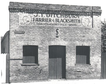
Photograph - J.T. DITCHBURN, FARRIER AND BLACKSMITH
Black and white photo ( copy ? ) with two additional copies ( faded ). Brick building, with central door and window either side. On top of building, printed ' J.T. Ditchburn, Farrier and Blacksmith, horses carefully shod' Appended with photo is photocopy of newspaper article ( Advertiser ? ) with photo of Mr. R.C. Watts and Mr. J.T. Ditchburn and accompanying article detailing their history and friendship. Photo is by P. Pinder.P. Pindercottage, miners, ditchburn, j.t., wattts, r.c., california gully, farrier, blacksmith, bootmaker -
 Bendigo Historical Society Inc.
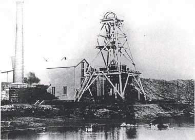
Photograph - LONG GULLY HISTORY GROUP COLLECTION: HERCULES/ENERGETIC MINE
Black and white photocopy of the Hercules/Energetic Mine. The photo shows the poppet legs, mine building and brick chimney. There is also heaps of tailings. In the foreground is a dam, with what looks like ducks/geese on it. Written on the back: One of the mines that Sir John Quick worked in. He used to drive a Horse Whim. Hercules / Energetic Mine. Energetic Mine first then amalgamated to H/E.bendigo, history, long gully history group, the long gully history group - hercules/energetic mine, sir john quick -
 Bendigo Historical Society Inc.
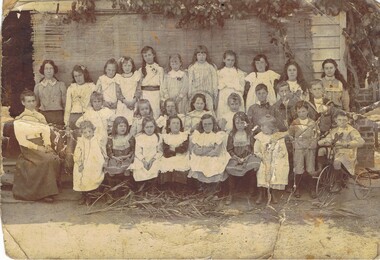
Photograph - SUNDAY SCHOOL PICNIC, Approx., 1900 ?
Sepia photo of three rows of school children on Sunday School picnic, teacher at left. Child at front right on tricycle. 28 children, 1 adult. In background, bamboo blind hanging in front of weatherboard wall, brick chimney ? at right. Grapevine ? at right and top. In foreground lying on ground reed stalks ? Some girls in pinafores, black stockings and boots. Boys in sailor suits and boots.person, group, sunday school picnic -
 Bendigo Historical Society Inc.
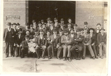
Photograph - BASIL MILLER COLLECTION: BENDIGO TRAMWAYS - GROUP PHOTO OF EMPLOYEES - ORIGINAL
Black and white photograph. Four rows of men posed in front of doorway of brick building. Tram tracks leading into doorway. Men dressed in suits, top hats. Man in front row left holding baby. Window to right of group has Bendigo Tramways written ( partly revealed ). Sign on far left above heads of men says positively No Admittance '94' on back in pencil.person, individual, basil miller -
 Bendigo Historical Society Inc.
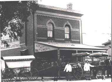
Photograph - HARRY BIGGS COLLECTION: VIEW POINT BUTCHERY EAGLEHAWK
Photograph. Harry Biggs Collection. 2 black & white photos. Square brick building with View Point Butchery sign. Iron sheets on verandah. To the right is a very similar building. In foreground are 3 horses, (1 partly out of the photo) with carts & 2 men with their butchers aprons. One wagon has J. H. Webster Wholesale & Retail sigh along the top. The sides are canvas.place, building, commercial, harry biggs collection, view point butchery, eaglehawk, j. h. webster -
 Bendigo Historical Society Inc.
Photograph - HARRY BIGGS COLLECTION: J T DITCHBURN FARRIER & BLACKSMITH
Photograph. Harry Biggs Collection. 4 black & white copies J. T. Ditchburn Farrier & Blacksmith: Horses carefully shod. A brick building, flat roofed with 2 windows & a door boarded up. There are 2 distinctive horse shoes nailed onto the sign. A street sign is also nailed to the building -Mt Korong Rd. - Also 1 negative Ditchburn Farrier California Gully.organization, business, commercial, harry biggs collection, j t ditchburn farrier & blacksmith, california gully -
 Bendigo Historical Society Inc.
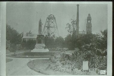
Slide - ALBERT RICHARDSON COLLECTION: HUSTLERS ROYAL RESERVE NO. 2 GOLD MINE
Slide. Hustlers Royal Reserve No.2 Gold Mine. Image taken in early 1900's. Mine was sited where the RSL building in Pall Mall is now located. Poppet head in background, Queen Victoria Statue in foreground, brick chimney on RH side and Post Office clock tower extreme right. Gardens in foreground. Photo taken fro 'Healthy Golden Bendigo' book.No. 29 printed on bottom of slidemine, gold, hustlers royal reserve no.2., bendigo mines-jack hattam collection. -
 Bendigo Historical Society Inc.
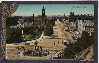
Photograph - CARWARDINE COLLECTION: PALL MALL BENDIGO
Coloured postcard, embellished with wattle left hand side, and kangaroo bottom Rh corner. Image shows Pall Mall, looking northwards. Post Office, Hustler's mine with brick chimney visible on left. Alexandra Fountain in centre bottom, horse drawn vehicles and two trams at Charing Cross. Henderson and Goode Beehive building and Shamrock Hotel on right. Receipt number 355/16bendigo, business, carwardine soap and candle -
 Stawell Historical Society Inc
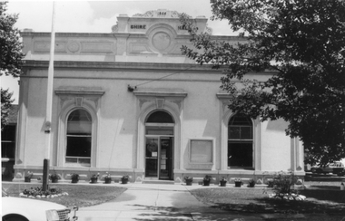
Photograph, Stawell Shire Hall Built in 1866
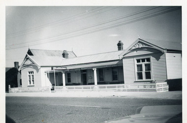
Stawell Shire Hall built 1866. These photographs of the Shire Hall, Longfield Street Stawell. This building has had many changes since 1866. Ronald Campbell, the Shire's second president laid the foundation of the hall on 28th April 1866. The contractors were Hutchings and Delbridge. The first Hall and office were the front part of the existing building. These rooms consisted of two 18 ft square rooms with an entrance hall separating them. The facade was almost the same as it is today. The building cost 502 pounds. Black and white photograph of a brick building which has been cement rendered with a parapet on top. The front of the building has 2 arched windows and arched entrance door. A glass notice board to the right of the door. Shire Hall 1866 is written on the top front of the building. Many small flower pots line either side of the front entrance with a flag post in the lawn on the left. stawell -
 Whitehorse Historical Society Inc.
Document, Villa Residence, 11/12/1937 12:00:00 AM
Auction brochure for 'beautiful modern brick villa residence', with 4 1/4 acres of land, Mitcham Road Mitcham, Saturday December 11 1937.Auction brochure for 'beautiful modern brick villa residence', with 4 1/4 acres of land, Mitcham Road Mitcham, Saturday December 11 1937, under instructions from the executors of the estate of the late E. E. Walker. Frontages to Mitcham Road, Delhi Street and Agra Street. Auctioneers: Baillieu Allard in conjunction with Drake & Co. Original copy framed, located in Map Drawer.Auction brochure for 'beautiful modern brick villa residence', with 4 1/4 acres of land, Mitcham Road Mitcham, Saturday December 11 1937.walker, edgar edwardes, walker estate, mitcham road, mitcham, delhi street mitcham, agra street, mitcham, drake & co., baillieu allard pty ltd -
 Kew Historical Society Inc
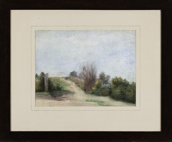
Work on paper - Entrance to the Kew Cemetery, Caroline Bell, c.1892
Boroondara General Cemetery, often referred to as Kew cemetery, is one of the oldest cemeteries in Victoria, Australia, created in the tradition of the Victorian garden cemetery. The cemetery, located in Kew, a suburb of Melbourne, is listed as a heritage place on the Victorian Heritage Register. Framed pastel drawing, donated to the Kew Historical Society in 1965 of the entrance to Boroondara General (Kew) Cemetery, believed to be drawn by the sister of the artist George Bell. The drawing shows one of the entrances to the Cemetery before the construction of the high brick wall in 1895. This would be consistent with the life of Caroline Bell (1872-1947). The artist's perspective is estimated to be near the west end of the cemetery, perhaps in Victoria Park.caroline ethel bell (1872-1947), boroondara general (kew) cemetery, victoria park -
 Kew Historical Society Inc
Photograph - Macauley's, Kew, 1924
Henry Beater Christian (1886-1962) , was a descendant of one of the earliest settler families in Kew. Employed at the Kew Asylum as a 'public servant', he was a skilled amateur photographer, photographing numerous scenes in Kew and on his travels around Victoria. The majority of his photographs date from 1916 to 1929. His finest photographs are housed in two photograph albums. A fine, early view of Macauley's boat sheds on the Yarra River at Kew. It is also one of the earliest views of Carnsworth, a notable mansion in Studley Park. Digital copy of a photograph from page 2 of the 47-page photograph album containing 261 gelatinous silver images, loaned by Diane Washfold with permission given to digitise and hold a copy in our collection. The photograph is of a stretch of the Yarra River at Kew. In the foreground are the boats of Macauley's Boat Sheds. On the horizon is the red brick tower of J Lewis Carnegie's house 'Carnsworth' in Stawell Street. "Macauley’s Kew"henry beater christian (1886-1962), landscape photography, kew (vic.) — yarra river, christian-washfold collection, photograph albums, macauley's boat sheds, carnsworth -- stawell street -- kew (vic.) -
 Kew Historical Society Inc
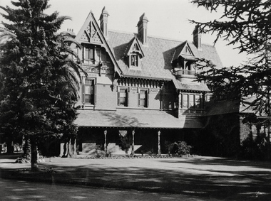
Photograph - 'Tara Hall', Studley Park Road, Marc Strizic (attrib), c.1960
'Lost Glories: a memorial to forgotten Australian buildings' was published by David Latta in 1986. It tells the story of a number of significant Australian buildings that had previously been demolished. A chapter in the book was devoted to Goathland, later known as Tara Hall. To supplement the text, he sourced photographs from a range of suppliers, chiefly the Royal Women's Hospital which had once owned Tara Hall, but had sold it in 1960. This is one of the photographs donated to KHS by the author.Tara Hall, Studley Park Road, circa 1957. The front of Tara Hall (previously named Byram, Goathland and Lowan). This triple-storey mansion with its elaborate gabled, steeply-pitched roofs and verandah was set back from Studley Park Road and concealed by a high brick fence. E. G. Kilburn, of Ellerker & Kilburn, designed Byram for the industrialist George Ramsden in 1888. Typed inscription on reverse: "Tara Hall at the time it was a home for nurses from the Royal Women's Hospital, Melbourne. (Royal Women's Hospital, Melbourne)."byram, goathland, tara hall, lowan, studley park (kew), george ramsden, sir malcolm mceacharn, edward george kilburn (architect), studley park road (kew) -
 Kew Historical Society Inc
Photograph - 'Carronbank', Marshall Avenue, 1980s
Carronbank (demolished) in Marshall Avenue, Kew was once the home of the Rev Graham Henty Balfour. It had extensive grounds, including a tennis court at the rear of the property. It remained a private residence until c.1960. The Department of Education purchased Carronbank as a school for partially sighted children, opening in February 1961 as State School No 4483. During the period 1961 to c.1980, the building housed a number of services. From 1969 to 1974, it was the site of Carronbank State School, later renamed Carronbank School for Deaf-Blind Children. In 1973, the Department established the Visiting Teacher Service for the Visually Impaired at the site. Its aim was to support teachers working in Victorian Government, Catholic and Independent Schools. From 1983 the school operated as Statewide Resource Centre for Visiting Teachers of the Vision Impaired. In 1988, the amalgamation of Princess Elizabeth Junior School for Deaf Children, the Monnington Centre and Carronbank School for Deaf Blind Students allowed the Victorian Government to sell each of the sites. Monnington [Adeney Avenue, Kew] reverted to private ownership, while Glendonald and Carronbank in Marshall Avenue were demolished and subdivided.The donor, Mr Murray Osler, was Principal of the Monnington Special Education Centre in Adeney Avenue (Kew) from 1976. This photo, and an accompanying drawing of 'Monnington' are important primary resources for the delivery of education to and for deaf-blind children in Victoria.The photograph, framed under perspex, shows the tennis court of Carronbank which had been converted into a play area for the students of the school. The flat roofed building may have been a toilet block, added for the school. The garage brick wall belongs to No 11. Grass is growing on the original asphalt court and there is equipment and tunnels for play. When sold the property was divided into three separate building blocks.carronbank -- marshall avenue -- kew (vic.), schools -- kew (vic.), carronbank -
 Kew Historical Society Inc
Photograph - Preshil (formerly 'Kalimna'), 12 Sackville Street, 1988
Documentary evidence records that in 1890 William H. Jarman, accountant, was the first owner and occupier of 'Kalimna', a substantial rwo-storey residence; it having an initial N.A.V. of £1503. In the following year the N.A.V. for the eleven-roomed property had increased to £2504 indicating that the building had been completed. Jarman is recorded as owning and occupying 'Kalimna' until at least 1910,Colour photographic positive of one of 'Kalimna'. The house is typical of the late Victorian period with polychromatic brick walls, a two storeyed, cast iron decorated verandah that spans two facades, and a polygonal bay window extending to the front. The eaves and chimneys are decorated with Italianate brackets executed in render. The slate roof remains intact, including its cast iron finials. (Kew Conservation Study, 1988)kalimna -- sackville street -- kew (vic.), preshil -
 Surrey Hills Historical Society Collection
Photograph, Sunbury Crescent, Surrey Hills looking towards the corner of Union Road, 1930s, 1930
Date is approximate. This is one of a series of photos donated by Arthur Lyons. Lyons family history: Arthur's father, Fred Lyons initially worked for George Rea's cab service until he set up his own business. He started with a horse and hansom cab but in time he changed over to a motor vehicle and continued his service until 1960. Frederick Adolphus Lyons (1891-1980) was born in Surrey Hills, son of Thomas and Catherine Lyons. He married Elizabeth Ruby Hall in 1918. They lived at 55 Sunbury Crescent. The Lyons’ home in Sunbury Crescent was called ‘Knopshambury’ - this was probably a misspelling of Knockshanbally in Co Kilkenny, the birth place of Fred’s father, Thomas Edmund Josias Lyons (1846-1915). Arthur Lyons was born in Surrey Hills on 12 Jun 1920. He became a motor mechanic / welder and lived his whole life at 55 Sunbury Crescent. The donation was made while he was in hospital. He died shortly afterwards (23 Sep 1990). Donation was finalised by a neighbour, Mrs Florence Ann Armitstead, wife of Glen Victor Armitstead. Glen was a local hairdresser. They moved to 11 Sunbury Crescent after their marriage in 1939. Arthur had no relatives to distribute the material to. The buildings date from circa 1887 and extended some way down Sunbury Crescent. The address was 63 Sunbury Crescent on the corner of Union Road. Built by Albert Mills for the Premier Land Agency; taken over by Timothy Leigh in 1893. The building housed a variety of shops – initially the land agency, but later shops included at various times a fruiterer, florist, carpenter, fishmonger, upholsterer, plumber. However, by the time this photo was taken in the 1930s it was occupied by Triumph Press. The printing industry continued to have a lasting presence. Triumph Press was followed by Surrey Press and in 1970 New Life Publications moved to the site from Abbotsford. It was about this time that this original building was demolished to make way for a modern print works. Gradually the needs of the printing business absorbed other properties along the Union Road frontage. The boy in the photo is Arthur (Tiger) Lyons and beside him is Alf Johnson, the local printer. The Lyons family lived adjacent to these buildings at 55 Sunbury Crescent.Black and white photo of a section of double-storey terrace buildings in Sunbury Crescent Surrey Hills, taken looking towards the corner of Union Road. The bricks are two-toned and laid in herringbone pattern. The verandah on the 2nd story is filled in with cast-iron lacework panels. There are 2 vintage cars in front of the terrace. A young boy sits on the running board beside a man dressed in suit and hat. printers, vintage cars, sunbury crescent, victorian style, union road shops, arthur lyons, arthur frederick lyons, alf johnson, triumph press, surrey press, new life publications, timothy leigh,, albert mills -
 Surrey Hills Historical Society Collection
Photograph, 181 Union Road, home of Mr and Mrs Antonio Clota
The house was built in 1910. The Clota and Sans families were part of a group of families of Spanish (Catalan) background who lived around Surrey Hills, many of whom are buried in Box Hill Cemetery. The house was built for Antonio and Josepha Clota and passed on to their daughter Josephine Sans and her family. Antonio's full name: Antonio Eusebio Miquel CLota (1869-1940; died Surrey Hills) had 3 brothers who came to Australia with him. Louis Clota (1864-1925); Marcus Clota (1866-1940) died Surrey Hills; Eusebio Clota (1869-1919). Their parents remained in Spain. Josephine Clota and Kim Sans had photos taken on the front entrance to the house when they were married on 9 May 1919. The wedding was reported in Punch.Black and white photo of the home of Mr and Mrs Antonio Clota; later the home of their daughter Josephine and son-in-law, Kim Sans and family. It shows bluestone curb and channelling in Union Road and a substantial wire mesh fence. The street tree looks like a plane tree and is a relatively young plant. Ther house is single storey brick with a tile roof and solid pillars supporting the verandah.houses, antonio clota, josepha comellas, josepha clota, catalan families, josephine clota, josephine sans, kim sans, joaquim sans, francis clota, frank clota, box hill cemetery -
 Surrey Hills Historical Society Collection
Photograph, 'Maitland', 1 Bedford Avenue, Surrey Hills, c 1900, 1900
Maitland' was built in 1889 for Thomas Zeplin, who was a Professor of Music. He owned all the land bound by Union Road, Wilson and Montrose Streets and the railway line. 1 Bedford Avenue stayed in family ownership until purchased by Camberwell Council in 1986, initially for a car park. However it was renovated to become part of Surrey Hills Neighbourhood Centre. It was opened on 23 November 1990. No 3 Bedford Avenue was built for Thomas Zeplin's daughter and named 'Mervyl' or 'Merryl'. Mrs Brodecky (donor) was the great-granddaughter of Thomas Zeplin. The 2 girls are granddaughters of Thomas Zeplin. Electoral roll information: 1972 & 1977: Albert Vojteck Brodecky, manager, 1 Bedford Avenue. 1977: Ray Nanette Brodecky. There are 2 copies. Thomas had this built for his son and family. The house was occupied by his family, though sometimes rented out. His great-grand-daughter Mrs. A. Brodecky sold to the Camberwell Council in 1986. This was the only surviving photo in the family after the fire. Courtesy: Mrs. A. BrodeckyBlack and white photo of 2 houses taken from the street front. On the LHS is a Victorian double-fronted single-storey villa of Hawthorn brick construction, with wrought iron lacework to the veranda, slate roof and picket fence, with an established garden. Next door at No 3 is a double-storey Victorian terrace with a similar fence and building materials. There are 2 young girls standing in front between the properties.maitland, bedford avenue, 1900, surrey hills neighbourhood centre, victorian style, mervyl, merryl, mr thomas zeplin, mrs nanette brodecky, mr albert vojteck brodecky -
 Lakes Entrance Historical Society
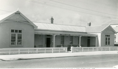
Postcard
Black and white photograph of Bellevue Guesthouse, depicting a substantial weatherboard building, iron roof, veranda across the front, supported by two concrete pillars. Identical gables at each end of the building with double sash windows and three window lights above. Brick chimneys with chimney pots. Wooden fence in 1950's style. Church visible beside and behind the Bellevue. Lakes Entrance Victoriaguesthouses, architecture -
 Charlton Golden Grains Museum Inc
Photograph, Charlton Post Office 1987, c.1987
First Post Office established in Camp St in 1878. Rebuilt on current site in 1879, current Post Office built 1940. Photo part of a Charlton Shire streetscape series 1987.Colour photo of Charlton Post Office. Red brick single storey building. Clock above entrance shows 5 minutes to nine. Yellow combi van, tree and public telephone on LH side of photo. Street light and rubbish bin on right of entrance. Signage above entrance says Post Office Charlton, ER and crown above the clock. Brown fence to right of building,charlton post office, charlton, business, industry, post office -
 Lakes Entrance Historical Society
Photograph - Nyerimilang, 1999
Nyerimilang Homestead is in public ownership, managed by Parks Victoria.Colour photograph of Nyerimilang Homestead showing front view, including rose garden. Situated off Kalimna West Road, Nungurner, it is a large white painted timber homestead, corrugated iron roof of hips and gables, painted green, five internal brick chimneys. Situated above the lake with views of Fraser Island and Flannagan Island, outer barrier and distant ocean. Nungurner Victoriahistoric buildings, local history -
 Charlton Golden Grains Museum Inc
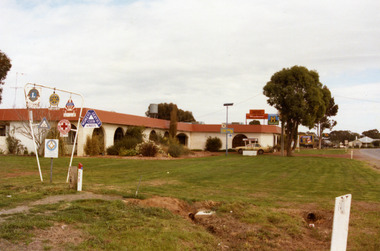
Photograph, Charlton Shire, Charlton Motel c. 1987, c.1987
The motel was built in the 1960s. Photo is part of a Charlton Shire streetscape series c.1987.Colour photograph of the Charlton Motel taken looking south east. The Motel is a white brick, single-storey building with a red trimmed roof. The verandah and some front windows are arches. There is a large garden bed with shrubs in front of the verandah. On the left are signs for various community organisations - Lions, Rotary, Apex, Young Farmers, Red Cross, and Amity. A cream coloured car is parked in the drive way business, charlton, motel -
 Whitehorse Historical Society Inc.
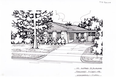
Artwork, other - Ink Line Drawing, 10 Alfred St., Burwood, 1999
A property illustration by Margaret Picken Commissioned by the real estate agency Woodards, Camberwell for the purpose of advertising 10 Alfred St., Burwood for sale in 1999. Made by using Rotring ‘Rapidigraph’ drafting pens with Rotring ink on Rapidigraph polyester drafting film, double matte. The suburb lines are believed to have been redrawn, making this property no longer in Burwood, but located in Glen iris. This property is listed as having sold for in 1999 for $380,000 Trained as a cartographic draftsman within the mining industry, Margaret Picken is an artist who worked producing property illustrations for real estate agencies in eastern suburbs of Victoria from 1983-2005. Retiring from the industry as technological changes favoured coloured photography over illustrations, and commissioning companies over sole contractors.This artwork is of Historical Significance as a record of local domestic architecture.A Black ink line drawing on drafters film by Maragret Picken, of 10 Alfred St., Burwood. Depicted is a one-story brick house situated back from a front lawn with a large tree, and a driveway on the right, leading to a connected carport. There to two hole punches just below the upper edge, and a approximately 1cmx1cm tape reside mark left of centre near the bottom edge 10 Alfred St., Burwood Maragret Picken - 99 Woodards - c'wellwhitehorse historical society, schwerkolt cottage, housing, architecture, margaret picken, burwood, glen iris, house, garden -
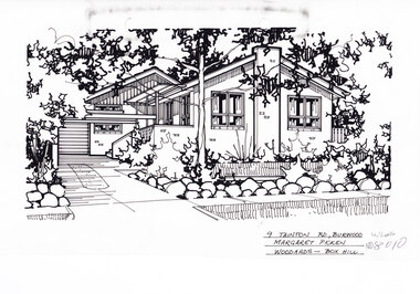 Whitehorse Historical Society Inc.
Artwork, other - Ink Line Drawing, 9 Tainton Rd., Burwood, circa 1990's
A property illustration by Margaret Picken Commissioned by the real estate agency Woodards Box Hill for the purpose of advertising 9 Tainton Rd., Burwood circa 1990's Made by using Rotring ‘Rapidigraph’ drafting pens with Rotring ink on Rapidigraph polyester drafting film, double matte. This property is listed as having had unit 10 sell for $137,000 in 1990 Trained as a cartographic draftsman within the mining industry, Margaret Picken is an artist who worked producing property illustrations for real estate agencies in eastern suburbs of Victoria from 1983-2005. Retiring from the industry as technological changes favored coloured photography over illustrations, and commissioning companies over sole contractors.This artwork is of Historical Significance as a record of local domestic architecture.A black ink line drawing on drafters film by Margaret Picken, of 9 Tainton St., Burwood. A single story brick house with multiple pitched roofs, to the left is a driveway leading to a garage in the background. and in front of the house is a lawn enclosed by a low rock fence and shrubbery. There are two hole punches near the upper edge, And a black wear mark running left below the upper edge9 Tainton Rd., Burwood Margaret Picken Woodards - Box Hillwhitehorse historical society, schwerkolt cottage, housing, architecture, margaret picken, burwood, house, garden -
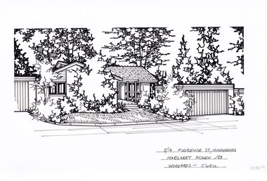 Whitehorse Historical Society Inc.
Artwork, other - Ink Line Drawing, Margaret Picken, 5/16 Florence St., Nunawading, 1993
A property illustration by Margaret Picken Commissioned by a real estate agency for the purpose of advertising 5/16 Florence St., Nunawading Made by using Rotring ‘Rapidigraph’ drafting pens with Rotring ink on Rapidigraph polyester drafting film, double matte. Trained as a cartographic draftsman within the mining industry, Margaret Picken is an artist who worked producing property illustrations for real estate agencies in eastern suburbs of Victoria from 1983-2005. Retiring from the industry as technological changes favored coloured photography over illustrations, and commissioning companies over sole contractors.This artwork is of Historical Significance as a record of local domestic architecture.A black ink line drawing on drafters film by Margaret Picken, of a black and white line drawing of a single story brick house with a path leading to the front door, from the public footpath. To the right is the separate garage. Trees and shrubs grow in garden beds in front of the buildings and in the background, while in front of the house is a front lawn. There are two holepunch holes centred just under the upper edge.5/16 Florence St., Nunawading Margaret Picken - 93 Woodards - C'wellwhitehorse historical society, schwerkolt cottage, housing, architecture, margaret picken, house, garden, real estate, nunawading -
 Lakes Entrance Historical Society
Photograph - Belleview Guesthouse, 1960c
On back 'Alf and Lucy Sandberg 1946 - 1988'Black and white photograph of Bellevue Guesthouse, depicting a substantial weatherboard building, iron roof, veranda across the front, supported by two concrete pillars. Identical gables at each end of the building with double sash windows and three window lights above. Brick chimneys with chimney pots. Wooden fence in 1950's style. Church visible beside and behind the Bellevue. Lakes Entrance Victoriaguesthouses, architecture -
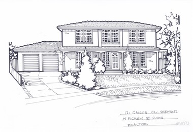 Whitehorse Historical Society Inc.
Artwork, other - Ink Line Drawing, Margaret Picken, 12 Gallus Cl., Vermont, 2002
A property illustration by Margaret Picken Commissioned by a real estate agency for the purpose of advertising 12 Gallus Cl., Vermont This property is listed as having sold for $425,000 in 2002 Made by using Rotring ‘Rapidigraph’ drafting pens with Rotring ink on Rapidigraph polyester drafting film, double matte. Trained as a cartographic draftsman within the mining industry, Margaret Picken is an artist who worked producing property illustrations for real estate agencies in eastern suburbs of Victoria from 1983-2005. Retiring from the industry as technological changes favored coloured photography over illustrations, and commissioning companies over sole contractors.This artwork is of Historical Significance as a record of local domestic architecture.A black ink line drawing on drafters film by Margaret Picken, of a black and white line drawing of a two story brick house with muntin windows, with a driveway on the left leading to a built in double garage. To the right of the house is a tall picket gate, while in the foreground is a front yard with garden beds and decorative trees. There are two hole punch holes just below centre of the upper edge12 Gallus Cl., Vermont M.Picken © 2002 Realtorwhitehorse historical society, schwerkolt cottage, housing, architecture, margaret picken, house, garden, real estate, vermont, vermont south -
 Victoria Police Museum
Police Stations (Ararat)
Ararat is a city in south-west Victoria, Australia, about 198 kilometres west of Melbourne, on the Western Highway on the eastern slopes of the Ararat Hills and Cemetery Creek valley between Victoria's Western District and the Wimmera. It is named after Mount Ararat 10 kilometres south-west of the town. A police station opened in Ararat in 1859, though there was a police presence in the area formerly known as Cathcart, Canton Lead and later Mount Ararat. In 1861 staff consisted of 1 Superintendent, 2 Mounted Constables, 1 Sergeant 2nd class, 1 Senior Constable, 8 Constables. The police reserve was on land bounded by Ligar Street, Barkley Street, Ingor Street and High Street. In 1930 the police station was described as a six-room brick dwelling with a slate roof, situated on one quarter acre of land. There was also a bathroom, wash-house, pantry, office, muster room and quarters for a single constable, stables with three stalls, and a lock-up consisting of two six-person cells. Later residences were located at 3 Ligar Street (brick veneer with a tile roof); 32A High Street (brick veneer with tile roof); and 3 Tobin Street (wood with an iron roof). A new, purpose built police station was opened in October 2010 at 77 Barkly Street. The Ararat Police District was reformed into the Wimmera Police District in 1870. Ararat Police Station became part of "R" (Glenelg) District in January 1948 and "M" (Highlands/Wimmera) District from March 1990. A list of police stationed at Ararat from 1903 - 1930 is available from the Victoria Police Museum8 photos comprising: 7 black & white photos 1 colour photopolice stations; ararat police station