Showing 4552 items matching "sources"
-
 Kew Historical Society Inc
Photograph - Flooding in the Willsmere Park, 1993
Willsmere Park is bounded by the the Yarra River, Green Acres Golf Club, Willow Grove and the Eastern Freeway. The land on which the park is now situated was bought by Thomas Wills at the Crown Land Sales of 1846 (Section 56). From the 1840s to the 1940s it was intensively farmed. The park is dominated by very large playing fields, while planting to the southern boundary was undertaken when the Eastern Freeway was built. It is only along the banks of the Yarra that there is any remnant native vegetation. Willsmere Park is of significance as an area of open land that remains from the flood plain that once dominated northern Kew. (Source: Kew Conservation Study, 1988)Original colour small format polaroid photograph of flooding in the Willsmere Park, taken on 16 September 1993."Flooding of shared path from Willsmere Billabong 16.9.93"willsmere park, yarra river -- floods -- kew (vic.), kew billabong -
 Kew Historical Society Inc
Photograph - Flooding in the Willsmere Park, 1993
Willsmere Park is bounded by the the Yarra River, Green Acres Golf Club, Willow Grove and the Eastern Freeway. The land on which the park is now situated was bought by Thomas Wills at the Crown Land Sales of 1846 (Section 56). From the 1840s to the 1940s it was intensively farmed. The park is dominated by very large playing fields, while planting to the southern boundary was undertaken when the Eastern Freeway was built. It is only along the banks of the Yarra that there is any remnant native vegetation. Willsmere Park is of significance as an area of open land that remains from the flood plain that once dominated northern Kew. (Source: Kew Conservation Study, 1988)Original colour small format polaroid photograph of flooding in the Willsmere Park, taken on 16 September 1993."Flooding of Willsmere Park from Yarra 16.9.93"willsmere park, yarra river -- floods -- kew (vic.) -
 Kew Historical Society Inc
Photograph - Flooding of Willsmere Park from Yarra, 1993
Willsmere Park is bounded by the the Yarra River, Green Acres Golf Club, Willow Grove and the Eastern Freeway. The land on which the park is now situated was bought by Thomas Wills at the Crown Land Sales of 1846 (Section 56). From the 1840s to the 1940s it was intensively farmed. The park is dominated by very large playing fields, while planting to the southern boundary was undertaken when the Eastern Freeway was built. It is only along the banks of the Yarra that there is any remnant native vegetation. Willsmere Park is of significance as an area of open land that remains from the flood plain that once dominated northern Kew. (Source: Kew Conservation Study, 1988)Original colour small format polaroid photograph of flooding in Willsmere Park resulting from heavy rain on 15 September 1993."Flooding of Willsmere Park from Yarra 16.9.93"yarra river -- floods -- kew (vic.), willsmere park -
 Kew Historical Society Inc
Photograph - Willsmere [Kew] Billabong, 1993
Willsmere Park is bounded by the the Yarra River, Green Acres Golf Club, Willow Grove and the Eastern Freeway. The land on which the park is now situated was bought by Thomas Wills at the Crown Land Sales of 1846 (Section 56). From the 1840s to the 1940s it was intensively farmed. The park is dominated by very large playing fields, while planting to the southern boundary was undertaken when the Eastern Freeway was built. It is only along the banks of the Yarra that there is any remnant native vegetation. Willsmere Park is of significance as an area of open land that remains from the flood plain that once dominated northern Kew. (Source: Kew Conservation Study, 1988)Original colour small format polaroid photograph of Willsmere [Kew] Billabong on September 1993."Willsmere Billabong 16.9.93"yarra river -- floods -- kew (vic.), willsmere park -
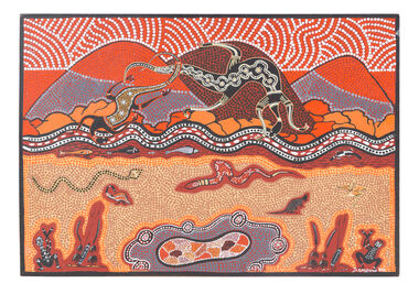 National Wool Museum
Painting - Ceremonial Hunting Grounds in the You Yangs, Stanley Couzens, 1993
Stanley Couzens, a Gunditjmara man and long-time Geelong resident, painted this story upon commission from the Geelong Wool Combing Company. It depicts hunting in the You Yangs, the distinctive granite peaks that overlook the region. In 1993, Couzens’ painting was translated into a pattern by textile designer Jenifer McMahon. It was then turned into a jumper using wool sourced entirely from the region. It was fully processed, from fleece to fabric, in Geelong. The jumper was given to attendees at the opening of the Geelong Wool Combing company on 10 December 1993. Among the many guests, was the Prime Minister Paul Keating. The painting was acquired with the permission of the Couzens family.Framed acrylic painting on board, showcasing the You Yangs mountain range, people, and local flora and fauna in warm earth tones. The painting is signed 'S. Couzens 93' in the bottom right hand corner. The painting is framed in a dark wooden frame.Bottom right corner - 'S. Couzens 93'you yangs, gunditjmara, aboriginal art, jenifer mcmahon, design, geelong wool combing company, jumper -
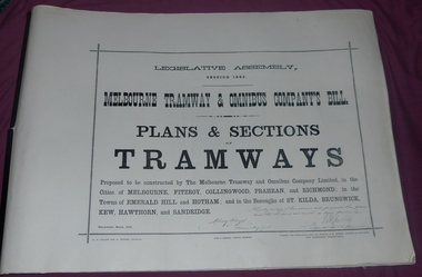 Melbourne Tram Museum
Document - Folder, Jack Cranston, "Melbourne Tramway & Omnibus Company's Bill - Plans and Sections - Tramways - March 1882", 1994
Consists of five sheets with notes about the proposed horse tram system for Melbourne, prepared by Jack Cranston. Includes extract and notes on the parliamentary enquiry and the possibility of a cable tram system. The coloured sheet is from another copy held at the former VicTrack Malvern Museum. Images from the latter set of documents - Sept 2024. 35 Sheets of details on the plans and sections of proposed horse tram lines throughout Melbourne. Produced as part of the work undertaken by Jack Cranston for the Department of Transport / Heritage Victoria - see Reg Item 584. On rear cover ink and on page 2 of the folder is a note on the source of the document. See Inscriptions.Yields information about the proposed horse tram lines by MTOCo that were later developed as cable tram lines.Folder - photocopies or copy prints, A1 approx. size, 45 sheets, clipped together with two black side binders, titled - "Melbourne Tramway & Omnibus Company's Bill - Plans and Sections - Tramways - March 1882". On rear cover sheet, handwritten in black ink - "Constructed and compiled by Jack Cranston by permission from The Ambleside Museum Ferntree Gully Victoria. This is a copy of Original Size Folio"trams, tramways, cable trams, horse trams, mto co, melbourne -
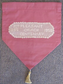 Uniting Church Archives - Synod of Victoria
Textile - Pulpit fall
This pulpit fall commemorates the second Wesleyan church structure that was brought to Mount Pleasant from Clayton's Hill and erected at the corner of Morton and Tress Streets. It was about 30 feet long, 18 feet wide with slab sides and a canvas roof. The Rev Theophilus Taylor was one of the first preachers to conduct services in this church. It was the second church on the site, the first being a canvas tent erected in 1854. In 1857 a third, wooden, church was built with side buttresses and was later enlarged by transepts on each side. The Rev. Albert Briggs was the minister at Mt Pleasant in 1955. [Source: Peers, T. (compiler) 'Mount Pleasant Church 1855 - 2005' ]Cream crochet sewn onto rose coloured curtain fabric with a gold tassel. "'MT PLEASANT CHURCH CENTENARY 1855 1955"mt pleasant methodist church ballarat, rev theophilus taylor, rev albert briggs -
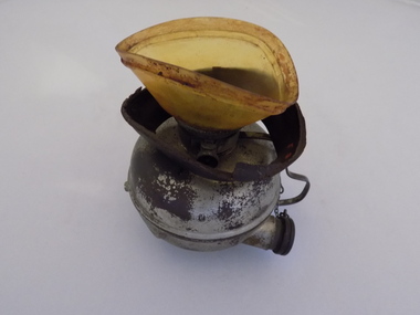 Geoffrey Kaye Museum of Anaesthetic History
Equipment - Inhaler, Hewitt, George Barth & Co. Ltd, c. 1895
Sir Frederic W. Hewitt (1857-1916), an accomplished and well respected English anesthesiologist, was an expert in the function and use of the Clover Ether Inhaler. In 1901, Hewitt described his modification of the Clover Inhaler. Often referred to as the Hewitt Wide-Bore Inhaler, Dr. Hewitt introduced changes in order to make it easier to breathe through the device and improve the ventilation of oxygen and carbon dioxide. In 1901, Hewitt was recruited to anesthetize King Edward VII for emergency abdominal surgery. This was just a day or so before the new King was to be coronated. He recovered well, and Hewitt became the first anesthesiologist ever to be knighted. (Source: Wood Library Museum)Tall black round topped box with brass hooks at the sides and brass hinges at rear. There is a brown fabric handle on the top. The box has red padding inside the lid and red lining inside the base and sides. There is a round section in the base of the box for holding the round clear glass bottle for ether. There is also a ellipse-shaped metal inhaler on small metal base with a thin metal handle and pipe with bakelite plug attached via a small metal chain. A brown mask is made of brown leather and celluloid which is connected to the inhaler. There is a metal ether measure for pouring the ether.On notecard in box: (B) HEWITT'S INHALER 1895, MADE BY GEO. BARTH & CO LTD., ADVERTISED AS THE SOLE MAKERS OF THE INHALER AND RECOGNISED BY HEWITT IN HIS TEXT BOOK - ANAESTHETICS AND THEIR ADMINISTRATION - AS THE MAKER OF HIS INHALER. / GIVEN BY DR. E.S. HOLLOWAY IN 1951, WHO ACQUIRED MUCH OF HOWARD JONES' EQUIPMENT AFTER THE LATTER'S DEATH. Stamped on underside of glass bottle in a circle: WUBW [illegible] Blue sticker on inhaler: O.2.13. Printed on inhaler under handle: Geo Barth [illegible] / SOL [illegible] Printed on body of inhaler: Full Printed on body of inhaler: 1/2 Printed on inside of leather mask: F35hewitt, sir frederic, jones, howard, inhaler, geo. barth & co. ltd., ether -
 Eltham District Historical Society Inc
Photograph - Aerial Photograph, Landata, Montmorency / Lower Plenty, 28 Jan. 1946
Centred on 32 Grand Boulevard, Montmorency bounded by Rattray Road to north, Main Road, Lower Plenty to south, Bolton Street to east and Looker Road to west. Historic Aerial Imagery Source: Landata.vic.gov.au Aerial Photo Details: Project No :5 Project : MELBOURNE AND METROPOLITAN AREA PROJECT Run : 34 Frame : 61778 Date : 12/1945 (28.1.46) Film Type : B/W Camera : EAG4 Flying Height : 10200 Scale : 6000 Film Number : 212 GDA2020 : 37°43'30"S, 145°07'37"E MGA2020 : 334934, 5823043 (55) Melways : 21 E8 (ed. 42)aerial photo, bolton steet, looker road, lower plenty, main road, montmorency, phoebe mason collection, rattray road -
 Eltham District Historical Society Inc
Photograph - Aerial Photograph, Landata, Montmorency / Lower Plenty, Jan. 1962
Centred on 147 Old Eltham Road, Lower Plenty bounded by Hurstbridge Railway Line to north, Yarra River to south, Main Road, Eltham to east and Heidelberg Golf Club to west. Historic Aerial Imagery Source: Landata.vic.gov.au Aerial Photo Details: Project No : 539 Project : MELBOURNE-GEELONG PROJECT Run : 6 Frame : 81 Date : 01/1962 Film Type : B/W Camera : RC5 Flying Height : 6000 Scale : 15840 Film Number : 1524 GDA2020 : 37°43'52"S, 145°07'26"E MGA2020 : 334685, 5822354 (55) Melways : 21 D9 (ed. 42)aerial photo, lower plenty, main road, montmorency, phoebe mason collection, eltham, eltham lower park, heidelberg golf club, hurstbridge railway line, main road eltham, yarra river -
 Eltham District Historical Society Inc
Photograph - Aerial Photograph, Landata, Montmorency / Lower Plenty, Feb. 1956
Centred on 20 Panorama Avenue, Lower Plenty bounded by Rattray Road to north, Yarra River to south, Bolton Street to east and Heidelberg Golf Club to west. Historic Aerial Imagery Source: Landata.vic.gov.au Aerial Photo Details: Project No : 250 Project : MELBOURNE OUTER SUBURBS PROJECT Run : 16A Frame : 53 Date : 02/1956 Film Type : B/W Camera : EAG9 Flying Height : 10000 Scale : 12000 Film Number : 1187 GDA2020 : 37°43'47"S, 145°07'25"E MGA2020 : 334645, 5822519 (55) Melways : 21 D9 (ed. 42)aerial photo, lower plenty, main road, montmorency, phoebe mason collection, bolton steet, heidelberg golf club, rattray road -
 Eltham District Historical Society Inc
Photograph - Aerial Photograph, Landata, Montmorency / Lower Plenty, Mar. 1987
Centred on 354-356 Main Road, Lower Plenty bounded by Rattray Road, Montmorency to north, Yarra River to south, Falkiner Street, Eltham to east and Lower Plenty shops to west. Historic Aerial Imagery Source: Landata.vic.gov.au Aerial Photo Details: Project No :1716 Project : WESTERN PORT FORESHORES Run : 16 Frame : 132 Date : 03/1987 Film Type : B/W Camera : RC10 Flying Height : 5600 Scale : 10000 Film Number : 4102 GDA2020 : 37°43'51"S, 145°07'38"E MGA2020 : 334968, 5822406 (55) Melways : 21 E9 (ed. 42)aerial photo, lower plenty, main road, montmorency, phoebe mason collection, eltham, eltham lower park, falkiner street, lower plenty shops, main road eltham, rattray road, yarra river -
 Eltham District Historical Society Inc
Photograph - Aerial Photograph, Landata, Montmorency / Lower Plenty, Nov. 1975
Centred on 328 Main Road, Lower Plenty bounded by Rattray Road, Montmorency to north, Rosehill Road to south, Falkiner Street to east and Lower Plenty shops to west. Historic Aerial Imagery Source: Landata.vic.gov.au Aerial Photo Details: Project No :1243 Project : (ALSO A.P. 1227) Run : 24A Frame : 146 Date : 11/1975 Film Type : B/W Camera : RC8 Flying Height : 5000 Scale : 10000 Film Number : 2722 GDA2020 : 37°43'40"S, 145°07'32"E MGA2020 : 334820, 5822743 (55) Melways : 21 D8 (ed. 42)aerial photo, lower plenty, main road, montmorency, phoebe mason collection, eltham lower park, falkiner street, lower plenty shops, rattray road, rosehill road -
 The Beechworth Burke Museum
Photograph - Photograph - Reproduction
This photograph depicts mining operations within the Beechworth area, in an unidentified valley where sluicing was utilised as a method for extracting gold from the environment. After gold was discovered in the region in 1851, sluicing became a characteristic of gold mining in the region - "Ovens miners carved intricate networks of races" throughout the region - involved the diversion of water in many channels, or water races, which contained inbuilt 'ripple devices' designed to trap gold for later extraction. By 1871, 900 miles of water races had been cut into the Beechworth Mining District. As suggested by the numerous figures involved in labouring along the water race, sluicing was a source of considerable employment within the region. This image is of important historical significance for its ability to convey information about sluicing and the methods used to find gold in the 1850s, and provides clues as to how sluicing and the widespread construction of water ranges changed the environment of the region. This image is important for current research into the history of the Ovens region in Victoria, which played such a prominent role in the early Australian gold mining industry. Therefore, this image has the capacity to be beneficial for research into society and the motivations of those living and working in this region during this period and therefore, has social significance. The Beechworth Burke Museum has additional images relating to gold sluicing and and the mining activities in the area more generally, which can be analysed and studied alongside images like this one.A black and white rectangular photograph printed on matte photographic paperbeechworth, mining, miners, labour, water race, sluicing -
 Eltham District Historical Society Inc
Photograph - Aerial Photograph, Landata, Eltham, Vic, Jan. 1951
Centred on Allison Crecent Reserve, Sherbrook Road and Scenic Crescent, Eltham bounded by Allendale Road to north, Dudley Street to south, Zig Zag Road to east and St Helena Road to west. Historic Aerial Imagery Source: Landata.vic.gov.au Aerial Photo Details: Project No :65 Project : MELBOURNE AND METROPOLITAN PROJECT NO. 2 Run : 7 Frame : 10 Date : 01/1951 Film Type : B/W Camera : EAG9 Flying Height : 12200 Scale : 12000 Film Number : 1419 GDA2020 : 37°42'14"S, 145°08'36"E MGA2020 : 336339, 5825416 (55) Melways : 21 H2 (ed. 42)Historical aerial photos and photo maps provide viusal evidence of the chronology of changes to the built landscape of the district and assist in dating other imagesaerial photo, 1951-01, eltham, neil webster collection, allendale road, allison crecent reserve, dudley street, melway 21h2, scenic crescent, sherbrook road, st helena road, zig zag road -
 Eltham District Historical Society Inc
Photograph - Aerial Photograph, Landata, Montmorency, Feb. 1956
Centred on present day Grand Boulevard and Olympic Way, Montmorency bounded by Diamond Street to north, Old Eltham Road and Eltham Lower Park to south, Bible Street to east and Para Road to west. Historic Aerial Imagery Source: Landata.vic.gov.au Aerial Photo Details: Project No :250 Project : MELBOURNE OUTER SUBURBS PROJECT Run : 17 Frame : 115 Date : 02/1956 Film Type : B/W Camera : EAG9 Flying Height : 10000 Scale : 12000 Film Number : 1176 GDA2020 : 37°43'24"S, 145°07'55"E MGA2020 : 335375, 5823236 (55) Melways : 21 F7 (ed. 42)aerial photo, 1956-02, neil webster collection, eltham, main road, montmorency, bible street, diamond street, eltham lower park, grand boulevard, melway 21f7, old eltham road, olympic way, para road -
 Eltham District Historical Society Inc
Photograph - Aerial Photograph, Landata, Eltham, Feb. 1956
Centred on present day Mount Plaeasant Road near Dalton Street, Eltham bounded by Luck Street to north, Eltham Lower Park to south, Reynolds Road to east and Central Park to west Historic Aerial Imagery Source: Landata.vic.gov.au Aerial Photo Details: Project No :250 Project : MELBOURNE OUTER SUBURBS PROJECT Run : 18 Frame : 93 Date : 02/1956 Film Type : B/W Camera : EAG9 Flying Height : 10000 Scale : 12000 Film Number : 1176 GDA2020 : 37°43'02"S, 145°09'38"E MGA2020 : 337871, 5823961 (55) Melways : 22 B6 (ed. 42)aerial photo, 1956-02, neil webster collection, eltham, central park, eltham lower park, luck street, melway 22b6, nyora road, reynolds road, dalton street, mount pleasant road -
 Eltham District Historical Society Inc
Photograph - Aerial Photograph, Landata, Eltham, Vic, Feb. 1956
Centred on present day Parsons Avenue at Leane Drive near the Maroondah Aqueduct, Eltham bounded by Lorimer Road to north, Thompson Crescent and Norman Road to south, Bells Hill Road to east and Parsons Road to west Historic Aerial Imagery Source: Landata.vic.gov.au Aerial Photo Details: Project No :250 Project : MELBOURNE OUTER SUBURBS PROJECT Run : 19 Frame : 5 Date : 02/1956 Film Type : B/W Camera : EAG9 Flying Height : 10000 Scale : 12000 Film Number : 1176 GDA2020 : 37°42'04"S, 145°11'09"E MGA2020 : 340064, 5825786 (55) Melways : 22 H1 (ed. 42)aerial photo, 1956-02, neil webster collection, allendale road, bells hill road, eltham, leane drive, lorimer road, maroondah aqueduct, melway 22h1, norman road, parsons road, research (vic.), thompson crescent -
 Eltham District Historical Society Inc
Photograph - Aerial Photograph, Landata, Eltham, Vic, Apr. 1963
Centred on present day Zig Zag Road and Main Road, Eltham bounded by Maroondah Aqueduct to north, Thompson Crescent and Arthur Street to south, Parsons Road to east and Glen Park Road and Banks Road to west. Historic Aerial Imagery Source: Landata.vic.gov.au Aerial Photo Details: Project No :486 Project : MELBOURNE (1963) PROJECT Run : 5 Frame : 59 Date : 04/1963 Film Type : B/W Camera : RC8 Flying Height : 5100 Scale : 9600 Film Number : 1805 GDA2020 : 37°42'24"S, 145°08'52"E MGA2020 : 336716, 5825114 (55) Melways : 21 J3 (ed. 42)aerial photo, neil webster collection, eltham, 1963-04, arthur street, banks road, glen park road, maroondah aqueduct, melway 21j3, parsons road -
 Eltham District Historical Society Inc
Photograph - Aerial Photograph, Landata, Eltham, Vic, Apr. 1963
Centred on present day Floriston Grove, Eltham bounded by Maroondah Aqueduct to north, Thompson Crescent and Diosma Road to south, Research Shops to east and Glen Park Road and Park West Road to west. Historic Aerial Imagery Source: Landata.vic.gov.au Aerial Photo Details: Project No :486 Project : MELBOURNE (1963) PROJECT Run : 5 Frame : 60 Date : 04/1963 Film Type : B/W Camera : RC8 Flying Height : 5100 Scale : 9600 Film Number : 1805 GDA2020 : 37°42'24"S, 145°09'29"E MGA2020 : 337622, 5825128 (55) Melways : 22 B3 (ed. 42)aerial photo, neil webster collection, eltham, 1963-04, diosma road, floriston grove, maroondah aqueduct, melway 22b3, park west road, research (vic.), research shops -
 Eltham District Historical Society Inc
Photograph - Aerial Photograph, Landata, Lower Plenty, Vic, Apr. 1963
Centred on present day Old Eltham Road near Araluen Centre, Lower Plenty bounded by Cromwell Street to north, Yarra River to south, Main Road at Mount Pleasant Road to east and Panorama Avenue to west. Historic Aerial Imagery Source: Landata.vic.gov.au Aerial Photo Details: Project No :486 Project : MELBOURNE (1963) PROJECT Run : 7 Frame : 231 Date : 04/1963 Film Type : B/W Camera : RC8 Flying Height : 5100 Scale : 9600 Film Number : 1805 GDA2020 : 37°44'03"S, 145°07'56"E MGA2020 : 335420, 5822027 (55) Melways : 21 F10 (ed. 42)aerial photo, neil webster collection, 1963-04, araluen, cromwell street, eltham, lower plenty, main road, melway 21f10, mount pleasant road, old eltham road, panorama avenue, yarra river -
 Eltham District Historical Society Inc
Photograph - Aerial Photograph, Landata, Eltham, Vic, Apr. 1963
Centred on present day Eltham Lower Park bounded by Brougham Street to north, Yarra River and Fitzsimons Lane Bridge to south, Main Road at Kent Hughes Road to east and Bolton Street to west. Historic Aerial Imagery Source: Landata.vic.gov.au Aerial Photo Details: Project No :486 Project : MELBOURNE (1963) PROJECT Run : 7 Frame : 232 Date : 04/1963 Film Type : B/W Camera : RC8 Flying Height : 5100 Scale : 9600 Film Number : 1805 GDA2020 : 37°44'03"S, 145°08'33"E MGA2020 : 336329, 5822040 (55) Melways : 21 H10 (ed. 42)aerial photo, neil webster collection, 1963-04, bolton steet, brougham steet, eltham, eltham lower park, fitzsimons lane bridge, kent hughes road, melway 21h10, yarra river -
 Eltham District Historical Society Inc
Photograph - Aerial Photograph, Landata, Eltham North, Vic, Apr. 1972
Centred on present day Eltham North reserve near Eltham North Primary School, Eltham North bounded by Allendale Road to north, Bellevue Road to south, Zig Zag Road and Beard Street to east and Ryans Road to west. Historic Aerial Imagery Source: Landata.vic.gov.au Aerial Photo Details: Project No :985 Project : MELBOURNE 1972 Run : 26 Frame : 190 Date : 04/1972 Film Type : B/W Camera : RC10 Flying Height : 5700 Scale : 9600 Film Number : 2636 GDA2020 : 37°41'52"S, 145°08'52"E MGA2020 : 336705, 5826102 (55) Melways : 11 J12 (ed. 42)aerial photo, neil webster collection, 1972-04, allendale road, beard street, bellevue road, eltham, eltham north, eltham north reserve, melway 11j12, ryans road, zig zag road, eltham north primary school -
 Eltham District Historical Society Inc
Photograph - Aerial Photograph, Landata, Research, Vic, Apr. 1972
Centred on present day Main Road, Research near Maroondah Aqueduct and Eltham College bounded by Allendale Road to north, Research-Warrandyte Road to south, Swipers Gully Training Restaurant to east and Reynolds Road to west. Historic Aerial Imagery Source: Landata.vic.gov.au Aerial Photo Details: Project No :985 Project : MELBOURNE 1972 Run : 26 Frame : 194 Date : 04/1972 Film Type : B/W Camera : RC10 Flying Height : 5700 Scale : 9600 Film Number : 2636 GDA2020 : 37°42'07"S, 145°11'07"E MGA2020 : 340015, 5825692 (55) Melways : 22 H1 (ed. 42)aerial photo, neil webster collection, 1972-04, allendale road, eltham college, main road, maroondah aqueduct, melway 22h1, research (vic.), research-warrandyte road, reynolds road, swiper's gully -
 Eltham District Historical Society Inc
Photograph - Aerial Photograph, Landata, Eltham, Vic, Apr. 1972
Centred on present day Diamond Creek Trail at the Eltham Leisure Centre bounded by Central Park to north, Main Road at Falkiner Street to south, MacMahon Ball Paddock to east and Grand Boulevard at Buena Vista Drive to west. Historic Aerial Imagery Source: Landata.vic.gov.au Aerial Photo Details: Project No :985 Project : MELBOURNE 1972 Run : 28 Frame : 207 Date : 04/1972 Film Type : B/W Camera : RC10 Flying Height : 5700 Scale : 9600 Film Number : 2635 GDA2020 : 37°43'25"S, 145°08'20"E MGA2020 : 335985, 5823223 (55) Melways : 21 G7 (ed. 42)aerial photo, neil webster collection, 1972-04, eltham, buena vista drive, central park, diamond creek trail, eltham leisure centre, falkiner street, grand boulevard, macmahon ball paddock, main road, melway 21g7 -
 Eltham District Historical Society Inc
Document - Property Binder, 963 Main Road, Eltham
Newspaper article: Big crowd sees Eltham P.O. openingThe News, 31 January 1958, Opening of new post office in Eltham. Program of proceedings: Official Opening of the new Eltham Post Office by Mr D C McKenzie M.P. Friday 14th February 1975. Typescript: A History of P.M.G. Services at Eltham, prepared by Derek M Baker, Post Office Historian-Victoria, 1975, including Chronology, text, list of Sources. Sheet of proceedings: Official Opening of the new Eltham Post Office including Historical Notes. Newspaper article: Diamond Valley News, 2 July 1985, Gold brought life to the township. main road, eltham, businesses, eltham post office, e p harmer, d c mckenzie m.p., w j b pollock, a s knox, senator a j missen, derek m baker, australia post, peter jolly -
 Eltham District Historical Society Inc
Photograph - Aerial Photograph, Landata, Eltham, Main Road; Mt Pleasant Rd to Railway Rd, Dec. 1945
Centred on Main Rd and Henry St, Eltham bounded by Railway Road to north, Mount Pleasant Road at Main Road to south, top of the hill in Arthur Street to east and Karingal Drive at Sherbourne Road to west. Historic Aerial Imagery Source: Landata.vic.gov.au Aerial Photo Details: Project No :65 Project : MELBOURNE AND METROPOLITAN PROJECT NO. 2 Run : 8 Frame : 70 Date : 01/1951 Film Type : B/W Camera : EAG9 Flying Height : 12200 Scale : 12000 Film Number : 1419 GDA2020 : 37°43'06"S, 145°08'45"E MGA2020 : 336589, 5823811 (55) Melways : 21 J6 (ed. 42)aerial photo, eltham, main road, henry street, arthur street, bolton street, eltham-yarra glen road, neil webster collection, 1951-01, dave lyon house, ernie andrew house, karingal road, melway 21j6, mount pleasant road, railway road -
 Glen Eira Historical Society
Article - Carrington Grove, 8, St Kilda East
A one page typed report dated 05/08/1989, by H Bullock and R Landells, containing a brief history of the house at 8 Carrington Grove from 1914 to 1989. The report provides a list of occupants and briefly mentions Charles Carrington and Lord Loch after whom Loch Avenue and Carrington Grove was named. The file also includes one page of accompanying handwritten working notes. The file also includes a photocopy of an article from a book, title and publication details unknown, containing a biography of Charles Robert Carrington. A one page research note by Chloe Stapleton, dated 08/05/2012, identifies the source of the article.carrington grove, st kilda east, loch avenue, heads of state, governors, officials, depression 1890s, economic depression, world war 1914-1918, carrington charles robert, harrop thomas s, harrop r, koesis l, mitchell n i, bullock h, landells r -
 Eltham District Historical Society Inc
Photograph, Percy Leason, Cartoon by Eltham resident, Percy Leason, 1931, 1931
Believed to be Percy Leason’s tribute to famous singer, Dame Nellie Melba, operatic soprano who died on 23 February 1931. The black and white drawing shows two men beneath a pedestal and sculpture of a head with the words “MELBA. A GREAT AUSTRALIAN”. Percy Leason (1889 - 1959) was a painter and cartoonist renowned for his depictions of Australian society in the 1920s and 1930s. He lived in Eltham from about 1924 to 1938 when he moved to the USA. In 1931 his cartoons were published in the Melbourne weekly magazine “Table Talk”, usually a whole page on page 8 or 9. (although it cannot be confirmed that this one was). Orignal source: Thomas Nelson, Carlton. This photo forms part of a collection of photographs gathered by the Shire of Eltham for their centenary project book,"Pioneers and Painters: 100 years of the Shire of Eltham" by Alan Marshall (1971). The collection of over 500 images is held in partnership between Eltham District Historical Society and Yarra Plenty Regional Library (Eltham Library) and is now formally known as 'The Shire of Eltham Pioneers Photograph Collection.' It is significant in being the first community sourced collection representing the places and people of the Shire's first one hundred years.Digital image and 4 x 5 inch B&W Negsepp, shire of eltham pioneers photograph collection, percy leason, nellie melba, cartoon, drawing -
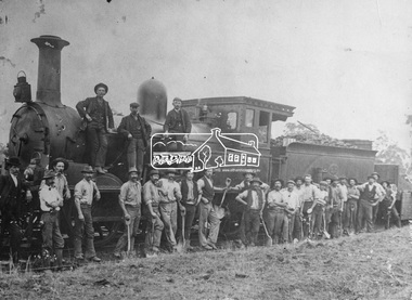 Eltham District Historical Society Inc
Negative - Photograph, Railway construction gang, Heidelberg-Eltham railway extension, c.1899-c.1901
Group of men, a railway construction gang, some with shovels, pose beside an old R-Class 0-6-0 steam locomotive (built by Phoenix Foundry) during construction of the Heidelberg to Eltham line circa 1899-1901. The first wagon contains track ballast and the sides have been lowered for the men to shovel it out for distribution on the track. The tall man without hat beside the tender is "Mrs Batherway's Grandfather". Mr Harry Batherway lived in Bridge St, Eltham, between Tillings Timber and Joslyn's and is the original source of this photo about 1970 when photos were collected from the community for the Eltham "Pioneers & Painters" history publication.This photo forms part of a collection of photographs gathered by the Shire of Eltham for their centenary project book,"Pioneers and Painters: 100 years of the Shire of Eltham" by Alan Marshall (1971). The collection of over 500 images is held in partnership between Eltham District Historical Society and Yarra Plenty Regional Library (Eltham Library) and is now formally known as 'The Shire of Eltham Pioneers Photograph Collection'. It is significant in being the first community sourced collection representing the places and people of the Shire's first one hundred years.Digital image 4 x 5 inch B&W Neg B&W Print 18 x 25 cm B&W Print 16 x 21.5 cmsepp, shire of eltham pioneers photograph collection, eltham, railway construction, railway gangers, railways, steam locomotive, workers, old r-class 0-6-0 steam locomotive