Showing 63 items matching "cartographic material"
-
![Map, Public Lands Office, Township of Sandridge [cartographic material] / lithographed at the Public Lands Office, March 30th 1859, 30 March 1859](/media/collectors/4f729f5897f83e0308601603/items/63c6354eae7bf372478c58b7/item-media/63c635d4ae7bf372478c7627/item-fit-380x285.jpg?cb=6) Mission to Seafarers Victoria
Mission to Seafarers VictoriaMap, Public Lands Office, Township of Sandridge [cartographic material] / lithographed at the Public Lands Office, March 30th 1859, 30 March 1859
... Township of Sandridge [cartographic material] / lithographed at the Public Lands Office, March 30th 1859....It also shows the name Gregory, a family of land owners who became the managers of the new building on the same site in 1889. sandridge bethel church customs house gregory Township of Sandridge [cartographic material] / lithographed at the Public Lands Office, March 30th 1859. ...The map shows where the land of the Customs House was and where the Bethel church was built in 1860. It also shows the name Gregory, a family of land owners who became the managers of the new building on the same site in 1889.sandridge, bethel church, customs house, gregory -
 Phillip Island and District Historical Society Inc.
Book, F.E. Hiscocks &? Co, F.E. Hiscocks &? Co.'s new Victorian counties atlas, 1874 [cartographic material] : together with map of Victoria, indicating roads, distances, relative position of counties, &?c, 1874
... s new Victorian counties atlas, 1874 [cartographic material] : together with map of Victoria, indicating roads, distances, relative position of counties, &?...s new Victorian counties atlas, 1874 [cartographic material] : together with map of Victoria, indicating roads, distances, relative position of counties, &? ...Labelled 'Cowes Free Public Library', 'Phillip Island Historical Society, Cleeland Bequest'.victoria, maps -
 Bayside Gallery - Bayside City Council Art & Heritage Collection
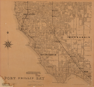
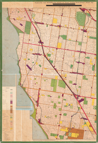
Map, Department of Crown Lands and Survey, Moorabbin, County of Bourke, c. 1918
... ...cartographic material...Moorabbin County of Bourke Map Plan land subdivision land titles Foreshores Sndringham Hampton Beaumaris Highett Cheltenham Department of Lands and Survey Land owners cartographic material Borough of Sandringham Brighton Photolithograph. ...The cadastral map of the Parish of Moorabbin in Victoria (L.6104) shows parish boundaries and land ownership c. 1918 when Sandringham was a Borough.moorabbin, county of bourke, map, plan, land subdivision, land titles, foreshores, sndringham, hampton, beaumaris, highett, cheltenham, department of lands and survey, land owners, cartographic material, borough of sandringham, brighton -
 Bayside Gallery - Bayside City Council Art & Heritage Collection
Map, Department of Crown Lands and Survey, Melbourne and Suburbs, City of Sandringham, 1917-1926
... ...cartographic material...Bayside Gallery - Bayside City Council Art & Heritage Collection Corner Wilson and Carpenter Streets Brighton melbourne map plan foreshores sndringham hampton beaumaris cheltenham department of lands and survey cartographic material borough of sandringham moorabbin black rock street map City of Sandringham Photolithograph. ...map, plan, foreshores, sndringham, hampton, beaumaris, cheltenham, department of lands and survey, cartographic material, borough of sandringham, moorabbin, black rock, street map, city of sandringham -
 Bayside Gallery - Bayside City Council Art & Heritage Collection
Map, H.B. Foot, Plan of the Brighton Estate containing 5120 acres, first special survey at Port Phillip, c. 1842
... ...cartographic material...Were survey plan map Brighton George Ward Cole Baker's lithographer Hibernian subdivision town planning cartographic material H.B. Foot Lithograph. Rectangular shaped sheet of cream paper with a central rectangular plan and three tinted drawings on the top, left and right sides printed in black ink. ...This plan records the Brighton Estate, also known as Dendy's Special Survey. In 1840 Henry Dendy, a farmer in Surrey, England acquired a "Special Survey" from the Commissioners for Land and Emigration which gave him the right to choose land in Port Phillip for the low price of £1 per acre for 5120 acres. Dendy appointed Jonathan Binns Were, as his agent, who later became a partner. Together, Dendy and Were decided on an area 5 miles south from Melbourne, bounded by North Road, East Boundary Road, South Road and to the west by Port Phillip Bay. Their Brighton Estate was first surveyed by T. S. Townsend in May 1841 and was re-surveyed by Robert Hoddle. Dendy and Were were making plans to sell the land and advertised a 30-guinea prize for the best subdivision which was to be divided into a village, marine residences, suburban and cultivation allotments, with the remainder being divided into country sections. The competition was won by H.B. Foot, who planned the village around a reserve and crescents and a 'green belt' forming the town boundary. brighton estate, dendy's special survey, special survey, henry dendy, jonathan binns were, w.b. were, survey, plan, map, brighton, george ward cole, baker's lithographer, hibernian, subdivision, town planning, cartographic material, h.b. foot -
 Bayside Gallery - Bayside City Council Art & Heritage Collection
Map, Department of Crown Lands and Survey et al, Moorabbin, County of Bourke, Government Roads, 1920
... ...cartographic material...Moorabbin County of Bourke Map Plan land subdivision land titles Foreshores Hampton Beaumaris Highett Cheltenham Department of Lands and Survey Land owners cartographic material Brighton Sandringham Town of Sandringham Government Roads Photolithograph of the Parish of Moorabbin (dated 17/7/1920) accompanied by original typed letter to the Town Clerk Sandringham from the Secretary for Department of Lands and Survey (dated 26/2/1934), notifying of dispatch of the map. ...The cadastral map of the Parish of Moorabbin in Victoria (L.6104) shows parish boundaries and land ownership 1920 when Sandringham was a Town. The government roads have been coloured in red pencil.moorabbin, county of bourke, map, plan, land subdivision, land titles, foreshores, hampton, beaumaris, highett, cheltenham, department of lands and survey, land owners, cartographic material, brighton, sandringham, town of sandringham, government roads -
 Bayside Gallery - Bayside City Council Art & Heritage Collection
Map, Department of Lands and Survey, Land under the control of the City of Sandringham, 1962
... ...cartographic material...Bayside Gallery - Bayside City Council Art & Heritage Collection Corner Wilson and Carpenter Streets Brighton melbourne The cadastral map showing land under the control of the City of Brighton in 1962. map plan foreshores sndringham hampton beaumaris cheltenham department of lands and survey cartographic material moorabbin black rock street map City of Sandringham Board of Lands and Works Print. ...The cadastral map showing land under the control of the City of Brighton in 1962.map, plan, foreshores, sndringham, hampton, beaumaris, cheltenham, department of lands and survey, cartographic material, moorabbin, black rock, street map, city of sandringham, board of lands and works -
 Bayside Gallery - Bayside City Council Art & Heritage Collection
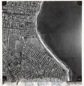
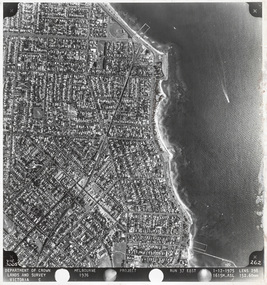
Photograph, Department of Crown Lands and Survey, Victoria, Melbourne Project: Brighton and Elwood, 1976
... ...cartographic material...This aerial photograph shows parts of Brighton and Elwood and was taken on 1 December 1976 Brighton Elwood Department of Crown Lands and Survey Aerial photograph Elsternwick Park Point Ormond North Road Ormond Esplanade St Kilda Street Glen Huntly Road Bayside Port Phillip Bay Map cartographic material Melbourne Project 1976 Black and white photograph. ...The Department of Crown Lands and Survey (1857-1983) was responsible for the administration of survey and mapping and the sale, occupation and management of crown land throughout its existence. This aerial photograph shows parts of Brighton and Elwood and was taken on 1 December 1976brighton, elwood, department of crown lands and survey, aerial photograph, elsternwick park, point ormond, north road, ormond esplanade, st kilda street, glen huntly road, bayside, port phillip bay, map, cartographic material, melbourne project 1976 -
 Bayside Gallery - Bayside City Council Art & Heritage Collection
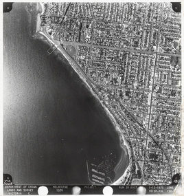
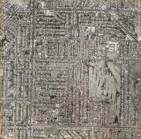
Photograph, Department of Crown Lands and Survey, Victoria, Melbourne Project: Brighton, Hampton, Sandringham, 1976
... ...cartographic material...This aerial photograph shows parts of Brighton, Hampton and Sandringham and was taken on 1 December 1976 Brighton Department of Crown Lands and Survey Aerial photograph Bayside Port Phillip Bay Map cartographic material Hampton Sandringham Green Point Sandringham Yacht Club South Road Beach Road Hampton Street Melbourne Project 1976 Black and white photograph. ...The Department of Crown Lands and Survey (1857-1983) was responsible for the administration of survey and mapping and the sale, occupation and management of crown land throughout its existence. This aerial photograph shows parts of Brighton, Hampton and Sandringham and was taken on 1 December 1976brighton, department of crown lands and survey, aerial photograph, bayside, port phillip bay, map, cartographic material, hampton, sandringham, green point, sandringham yacht club, south road, beach road, hampton street, melbourne project 1976 -
 Bayside Gallery - Bayside City Council Art & Heritage Collection
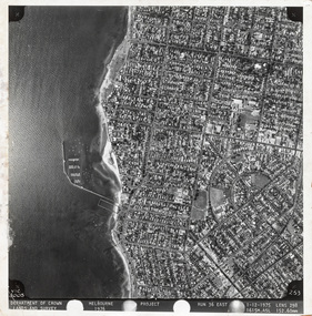
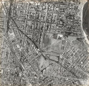
Photograph, Department of Crown Lands and Survey, Victoria, Melbourne Project: Brighton, 1976
... ...cartographic material...This aerial photograph shows parts of Brighton and was taken on 1 December 1976 Brighton Department of Crown Lands and Survey Aerial photograph Bayside Port Phillip Bay Map cartographic material Melbourne Project 1976 Brighton Yacht Club Middle Brighton Baths North Road St Kilda Street New Street Black and white photograph. ...The Department of Crown Lands and Survey (1857-1983) was responsible for the administration of survey and mapping and the sale, occupation and management of crown land throughout its existence. This aerial photograph shows parts of Brighton and was taken on 1 December 1976brighton, department of crown lands and survey, aerial photograph, bayside, port phillip bay, map, cartographic material, melbourne project 1976, brighton yacht club, middle brighton baths, north road, st kilda street, new street -
 Bayside Gallery - Bayside City Council Art & Heritage Collection
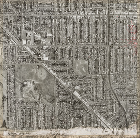
Photograph, Department of Crown Lands and Survey, Victoria, Melbourne Project: Brighton and Hampton, 1976
... ...cartographic material...Brighton Department of Crown Lands and Survey Aerial photograph Bayside Port Phillip Bay Map cartographic material Melbourne Project 1976 Brighton Yacht Club Middle Brighton Baths Hampton Green Point Brighton Beach South Road The Esplanade Hampton Street Black and white photograph. ...The Department of Crown Lands and Survey (1857-1983) was responsible for the administration of survey and mapping and the sale, occupation and management of crown land throughout its existence. This aerial photograph shows parts of Brighton and Hampton and was taken on 1 December 1976. brighton, department of crown lands and survey, aerial photograph, bayside, port phillip bay, map, cartographic material, melbourne project 1976, brighton yacht club, middle brighton baths, hampton, green point, brighton beach, south road, the esplanade, hampton street -
 Bayside Gallery - Bayside City Council Art & Heritage Collection
Photograph, Department of Crown Lands and Survey, Victoria, Brighton, Elwood and Elsternwick, c. 1965-71
... ...cartographic material...Brighton Department of Crown Lands and Survey Aerial photograph Bayside Port Phillip Bay Map cartographic material Elwood Elsternwick Elsternwick Park Elwood Tram Depot Elwood Pier New Street Glen Huntly Road St Kilda Street Nepean Highway Black and white photograph. ...The Department of Crown Lands and Survey (1857-1983) was responsible for the administration of survey and mapping and the sale, occupation and management of crown land throughout its existence. This aerial photograph shows parts of Brighton, Elwood and Elsternwick and was taken circa 1965-71.brighton, department of crown lands and survey, aerial photograph, bayside, port phillip bay, map, cartographic material, elwood, elsternwick, elsternwick park, elwood tram depot, elwood pier, new street, glen huntly road, st kilda street, nepean highway -
 Bayside Gallery - Bayside City Council Art & Heritage Collection
Photograph, Department of Crown Lands and Survey, Victoria, Brighton, Brighton East and Bentleigh, c. 1965-71
... ...cartographic material...Brighton Department of Crown Lands and Survey Aerial photograph Bayside Port Phillip Bay Map cartographic material Bentleigh Brighton East Dendy Park Dendy Street Centre Road nepean highway South Road Football Black and white photograph. ...The Department of Crown Lands and Survey (1857-1983) was responsible for the administration of survey and mapping and the sale, occupation and management of crown land throughout its existence. This aerial photograph shows parts of Brighton, Brighton East and Bentleigh and was taken circa 1965-71.brighton, department of crown lands and survey, aerial photograph, bayside, port phillip bay, map, cartographic material, bentleigh, brighton east, dendy park, dendy street, centre road, nepean highway, south road, football -
 Bayside Gallery - Bayside City Council Art & Heritage Collection
Photograph, Department of Crown Lands and Survey, Victoria, Brighton, Brighton East and Bentleigh, c. 1965-71
... ...cartographic material...Brighton Department of Crown Lands and Survey Aerial photograph Bayside Port Phillip Bay Map cartographic material Brighton East Dendy Park Dendy Street Centre Road nepean highway South Road Brighton Golf Course Golf Black and white photograph. ...The Department of Crown Lands and Survey (1857-1983) was responsible for the administration of survey and mapping and the sale, occupation and management of crown land throughout its existence. This aerial photograph shows parts of Brighton and Brighton East and was taken circa 1965-71.brighton, department of crown lands and survey, aerial photograph, bayside, port phillip bay, map, cartographic material, brighton east, dendy park, dendy street, centre road, nepean highway, south road, brighton golf course, golf -
 Bayside Gallery - Bayside City Council Art & Heritage Collection
Map - print, Melbourne and Metropolitan Board of Works, Interim development order: Brighton, Moorabbin and Sandringham, 1959
... ...cartographic material...Brighton Moorabbin Sandringham Melbourne and Metropolitan Board of Works Map Town Planning cartographic material Interim development order Bayside Print. ...The Melbourne and Metropolitan Board of Works (now Melbourne Water) was established in 1891. From that time, as part of their work laying water and sewerage connections, they created detailed plans of houses and other buildings in the Melbourne metropolitan area. In 1956 it acquired powers to construct and maintain highways and bridges, protect and improve the foreshores and create and maintain parks within the metropolitan region. This Interim development order comprises part of the municipalities of Brighton, Moorabbin and Sandringham and was made on 20 October 1959.brighton, moorabbin, sandringham, melbourne and metropolitan board of works, map, town planning, cartographic material, interim development order, bayside -
 Narre Warren and District Family History Group
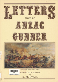
Book, Lyall's Yarns Pty Ltd, Letters from an ANZAC gunner, 1990
... xxiii, 214 p., [2] p. of plates : ill., cartographic materials, ports. ; 30 cm....Narre Warren and District Family History Group 110 High Street Berwick melbourne World War 1914-1918 Brian Lyall This book contains letters from an Anzac Gunner xxiii, 214 p., [2] p. of plates : ill., cartographic materials, ports. ; 30 cm. Letters from an ANZAC gunner Book Lyall's Yarns Pty Ltd Brian Lyall ...This book contains letters from an Anzac Gunnerxxiii, 214 p., [2] p. of plates : ill., cartographic materials, ports. ; 30 cm.non-fictionThis book contains letters from an Anzac Gunnerworld war 1914-1918, brian lyall -
 Anglesea and District Historical Society
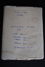
Map, Royal Australian Survey Corps, Anglesea, Victoria, 1954
... Anglesea, Victoria [cartographic material] produced by Royal Australian Survey Corps. ...Anglesea and District Historical Society 5B McMillan Street Anglesea great-ocean-road anglesea map topographic map (See above) Anglesea, Victoria [cartographic material] produced by Royal Australian Survey Corps. ...Anglesea, Victoria [cartographic material] produced by Royal Australian Survey Corps. Colour; Scale [1:63,360] 1 mile to 1 inch; transverse Mercator projection; Sheet No. 866, Zone 7. Two stamps: 1. Rankine and Dobbie Pty Ltd. 2. Authorised for sale / Price 2/- / By Department of the Army Original date: November 1928.(See above)anglesea map, topographic map -
 Bendigo Historical Society Inc.
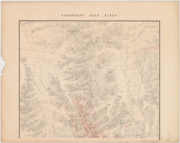
Map - Sandhurst Goldfield 1873, 1873
... Title: Sandhurst gold field [cartographic material] / surveyed and compiled under the direction of R. ...Title: Sandhurst gold field [cartographic material] / surveyed and compiled under the direction of R. ...Robert Brough Smyth (1830-1889), civil servant and mining engineer, was born on 18 February 1830 near Wallsend, Northumberland, England, son of Edward Smith, mining engineer, and his wife Elizabeth, née Brough. On 14 November 1852 Smyth arrived in Melbourne and went to the gold diggings, where he worked as a carter on the construction of roads at Sawpit Gully. Back in Melbourne, on 7 November 1853 he became a draftsman under the surveyor-general, Andrew Clarke, and soon was acting chief draftsman. Smyth compiled numerous reports and wrote catalogues for exhibitions of minerals and fossils. In November 1869 he superintended the establishment of a museum of economic geology, mineralogy and mining and published in Melbourne The Gold Fields and Mineral Districts of Victoria … Covertly involved in the controversy that led to the disbanding of the Geological Survey in 1869, he became its director on its reinstatement in 1871; he increased its part in the search for and proving of economic mineral and coal deposits. In 1875 he became chief inspector of mines and published the geological reports on John Forrest's Western Australian exploration. On 19 June 1860 Smyth had become honorary secretary to the Board for the Protection of Aborigines and in 1863 became a voting member. Zealous and determined, he assumed the role of chairman, which belonged ex officio to the chief secretary, and wielded great power, including the dubious dismissal of John Green, general inspector of Aborigines in 1861-75 with whom he had earlier collaborated. Smyth's compilation, The Aborigines of Victoria … (1878), arose from his efforts to gather information and artefacts of Victorian Aboriginal cultures at a time when their vestiges were fast disappearing. The work, still valuable though long since superseded, relied heavily upon others such as L. Fison, G. B. Halford, A. Howitt and J. Milligan. Press reports and a petition from officers in the Mining Department accused Smyth of 'tyrannical and overbearing conduct', and in February 1876 a board of inquiry was constituted and heard evidence until April. McCoy defended 'one of the best heads of department he had ever known' but the board found the charges of 'excessive severity … in the main substantiated', and reported that Smyth had been irritable, lacking self-control and over-fastidious, but acknowledged his 'unremitting energy and zealous labours in the public service'. On 4 May Smyth resigned all public offices except his membership of the Aborigines' board. Source: Australian Dictionary of Biography. https://adb.anu.edu.au/biography/smyth-robert-brough-4621Original map printed on paper on canvas; copy of map with original. Title: Sandhurst gold field [cartographic material] / surveyed and compiled under the direction of R. Brough Smyth and Thos. Couchman, Angus Mackay ; additions made to the survey under the same direction by Regd. A.F. Murray, April 1873. "Lithd. by R. Shepherd" Topographic map of Sandhurst gold field, with relief shown by hachures. Shows roads, railways and public buildings. "Note - blocks held under leasing regulations are outlined and numbered in red" Map is also available on State Library Victoria: https://find.slv.vic.gov.au/discovery/fulldisplay?vid=61SLV_INST:SLV&search_scope=slv_local&tab=searchProfile&context=L&docid=alma994975393607636 sandhurst, goldfield, lease holdings, gullies, brough smyth, state library of victoria -
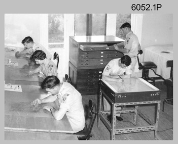 Bendigo Military Museum
Photograph - Scribing at the Army Survey Regiment, c1950s to 1979
... Scribing was the cartographic process of drafting topographic features such as drainage, relief, vegetation, roads and culture on specially coated map reproduction material. ...Scribing was the cartographic process of drafting topographic features such as drainage, relief, vegetation, roads and culture on specially coated map reproduction material. ...These 10 photographs were taken over two decades from the late 1950s to 1979 at the Army Survey Regiment, Fortuna, Bendigo. The two photos taken in 1961 are annotated with named personnel and the date. The other photos are not annotated with dates, locations and names of personnel, although the technicians in the last three photos taken in 1979 are positively identified. The photos were most likely taken in the Ballroom, Ante Room and Attic, Cartographic Squadron’s main production rooms on the top floor of Fortuna Villa. Scribing was the cartographic process of drafting topographic features such as drainage, relief, vegetation, roads and culture on specially coated map reproduction material. The cartographic technician scribed out the map feature such as a creek to a specified line width on the map sheet, using a tool affixed with a metal or sapphire tipped cutter.This is a set of 10 photographs of technicians scribing topographic features at the Army Survey Regiment, Bendigo. The photographs were printed on photographic paper and are part of the Army Survey Regiment’s Collection. The photographs were scanned at 300 dpi. .1) - Photo, black & white, c1950s. unidentified personnel in Cartographic Squadron .2) - Photo, black & white, c1960s. unidentified personnel in Cartographic Squadron .3) - Photo, black & white, c1960s. unidentified personnel in Cartographic Squadron Attic .4) - Photo, black & white, c1960s. Cartographic Squadron Attic .5) - Photo, black & white, Oct 1961. L to R: PTE P. Carseldine, PTE H.S. Pasley, PTE C.A. Brown, WO2 M.A. McLaren, CPL Jennifer H. Murray. Cartographic Squadron .6) - Photo, black & white, Oct 1961. CPL Jennifer H. Murray. Cartographic Squadron .7) - Photo, black & white, 1979. SPR Mick Ellis in Cartographic Squadron .8) - Photo, black & white, 1979. SPR Mark Casey in Cartographic Squadron .9) - Photo, black & white, 1979. SPR Sharon (Jones) Treble in Cartographic Squadron .10) - Photo, black & white, 1961. PTE BJ Madex. Cartographic Squadron.1 to .4 - annotated “Scribing” .5 – annotated “Scribing PTE P. Carseldine, PTE H.S. Pasley, PTE C.A. Brown, WO2 M.A. McLaren, CPL Jennifer H. Murray. Oct 1961” .6 - annotated “Scribing CPL Jennifer H. Murray. Oct 1961” .7 to .9 - annotated “Scribing” .10 – annotated “PTE Madex Oct 61”royal australian survey corps, rasvy, army survey regiment, army svy regt, fortuna, asr, carto -
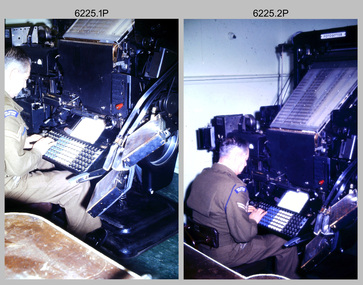 Bendigo Military Museum
Photograph - Cartographic Production – Army Survey Regiment, Fortuna, Bendigo, c1960 -1975
... The scribing process as shown in photos .8P to .9P was the cartographic process of drafting features such as drainage, relief, vegetation, roads and culture on specially coated map reproduction material. ...The scribing process as shown in photos .8P to .9P was the cartographic process of drafting features such as drainage, relief, vegetation, roads and culture on specially coated map reproduction material. ...This is a set of 10 photographs of Cartographic Squadron technicians undertaking map production tasks in at the Army Survey Regiment, Fortuna, Bendigo circa 1968 to 1975. Production was undertaken on the top floor of Fortuna Villa. The Fotosetter type setting machine shown in photos .1P and .2P. replaced the letterpress method of type production in 1956. CPL Arty Lane specialised in the operation of the Fotosetter type setting machine for many years. For more information on the Fotosetter, see page 71 of Valerie Lovejoy’s book 'Mapmakers of Fortuna – A history of the Army Survey Regiment’ ISBN: 0-646-42120-4. The computer based Editwriter Model 7500 typesetting system shown in photos .3P and .4P. was introduced in 1975 as a replacement to the aging Fotosetter. It was operated by a specialised technician, who generated a large variety of map type styles and sizes quickly and reliably, as well as text panels. Output on Copy proof adhesive backed stripping type film replaced messy wax and spray adhesives in 1978. The Editwriter capability supported all RASvy units and its contractor type setting requirements. The Aristo Co-ordinatorgraph shown in photos .5P to .7P was introduced in 1962. It was a large heavy steel framed light table with a scribing head that moved in a XY direction using a vernier calibrated measuring scale to 0.001 of an inch. Whilst hand operated it was much quicker and accurate than manual grid and graticule calculation, plotting and scribing. The history of co-ordinatorgraphs is covered in more detail with additional historic photographs, in pages 50 to 51 and page 88 of Valerie Lovejoy’s book 'Mapmakers of Fortuna – A history of the Army Survey Regiment’ ISBN: 0-646-42120-4. The scribing process as shown in photos .8P to .9P was the cartographic process of drafting features such as drainage, relief, vegetation, roads and culture on specially coated map reproduction material. The cartographic technician scribed out the map feature such as a contour to a specified line width on the map sheet, using a tool affixed with a sapphire tipped cutter. The quality control edit (Proving) stage of map production shown in photo .10P was the first opportunity to independently and systematically inspect a proof of the map.This is a set of 10 photographs of cartographic Squadron technicians undertaking map production tasks at the Army Survey Regiment, Fortuna, Bendigo, c1968 to c1975. The photographs were on 35mm colour slides and scanned at 96 dpi. They are part of the Army Survey Regiment’s Collection. .1) to .2) - Photo, colour, c1968, Fotosetter type setting machine, CPL Arty Lane. .3) to .4) - Photo, colour, c1975, Typesetting machine, ‘Editwriter’ Model 7500. .5) - Photo, colour, c1960s, PTE Desi Asaris and CPL Kalen Sargent operating Aristo Co-ordinatorgraph equipment. .6) - Photo, colour, c1970s, L to R: CPL Desi Asaris, CPL John Bennett, operating Aristo Co-ordinatorgraph equipment. .7) - Photo, colour, c1970s, L to R: CPL John Bennett, CPL Desi Asaris operating Aristo Co-ordinatorgraph equipment. .8) - Photo, colour, c1970s, L to R: CPL Desi Asaris scribing drainage, CPL John Bennett. .9) - Photo, colour, c1970s, CPL Desi Asaris scribing drainage. .10) - Photo, colour, c1970s, L to R: CPL Desi Asaris, CPL John Bennett and their supervisor WO2 Roger Rix inspecting features on an aeronautical chart proof. .1P to .10P There are no annotations stored with the 35mm slides.royal australian survey corps, rasvy, army survey regiment, army svy regt, fortuna, asr, carto -
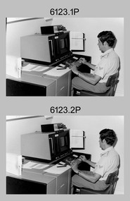 Bendigo Military Museum
photograph - Cartographic Squadron Production – Army Survey Regiment, Fortuna, c1980
... Scribing was the cartographic process of drafting features such as drainage, relief, vegetation, roads and culture on specially coated map reproduction material. ...Scribing was the cartographic process of drafting features such as drainage, relief, vegetation, roads and culture on specially coated map reproduction material. ...This collection of 12 photos was most likely taken in 1980. The photos were most likely taken in Cartographic Squadron’s Ante Room, the Attic and small offices on the top floor of Fortuna Villa. The computer based Editwriter typesetting system was introduced in 1975 as a replacement to the aging Fotosetter machine. It was operated by a specialised technician, who generated a large variety of map type styles and sizes quickly and reliably, as well as text panels. CPL Richards performed this task for several years and in photo .1P and .2P is reading off a type order next to the computer monitor. Output on Copy proof adhesive backed stripping type film replaced messy wax and spray adhesives in 1978. The Editwriter capability supported all RASvy units and contractor type setting requirements. Scribing was the cartographic process of drafting features such as drainage, relief, vegetation, roads and culture on specially coated map reproduction material. The cartographic technician scribed out the map feature such as a contour to a specified line width on the map sheet, using a tool affixed with a sapphire tipped cutter. The quality control edit (Proving) stage of map production was the first opportunity to inspect a proof of the map independently and systematically. Proving tasks were carried out by technicians conversant of the map product specification and task requirement, however, was not involved in its production. Corrections were identified, marked up and sent to back to the correcting section or contractors. Terrain Embossing was a manual map production technique to produce hill shading on medium to small scale graphics and air charts. SPR John Martin is seen in photos .8P to.10P using a fine embossing metal stylus to push down on the drainage impression on a thin malleable opaque plastic material (AK Poligraphy). Ridge lines were then pushed down using the contour impression as a guide, on the opposing side of the AK Poligraphy to create a 3D plastic model terrain effect. The map impression was sprayed with white paint and photographed to create a contone tone hill shade. SPR Gina (Coore) Neilson is seen in photo .11P washing a contone positive of a land mass in a solution. The contone components were registered to the map sheet, as shown in photo .12P and masked using an air brush and a halftone negative was then created. The terrain embossing method of producing hill shading was more efficient to produce than previous specialised artistic methods such pencil/eraser and air brush. Furthermore, a more consistent enhancement of terrain on charts was achieved between technicians.This is a set of 12 photographs of Cartographic Squadron performing four map production tasks at the Army Survey Regiment, Fortuna, Bendigo c1980. The first ten photographs were on 35mm negative film and were scanned at 96 dpi. Photos .11P and .12P were on photographic paper and scanned at 300 dpi. They are part of the Army Survey Regiment’s Collection. .1) - Photo, black & white, c1980, Editwriter typesetter, CPL Paul Richards. .2) - Photo, black & white, c1980, Editwriter typesetter, CPL Paul Richards. .3) - Photo, black & white, c1980, Scribing contours on a RAAF Chart, SPR Megan (McBurney) Reynolds. .4) - Photo, black & white, c1980, Scribing contours on a RAAF Chart, SPR Megan (McBurney) Reynolds. .5) - Photo, black & white, c1980, Scribing contours on a RAAF Chart, SPR Rod Skidmore. .6) - Photo, black & white, c1980, Scribing contours on a RAAF Chart, SPR Rod Skidmore. .7) - Photo, black & white, c1980, Formal quality control edit (Proving), CPL Ian Belmont. .8) - Photo, black & white, c1980, Hill Shade Terrain Embossing, SPR John Martin. .9) - Photo, black & white, c1980, Hill Shade Terrain Embossing, SPR John Martin. .10) - Photo, black & white, c1980, Hill Shade Terrain Embossing, SPR John Martin. .11) - Photo, black & white, c1980, Hill Shade Terrain Embossing, SPR Gina (Coore) Neilson. .12) - Photo, black & white, c1980, Hill Shade Terrain Embossing, unidentified..1P to .10P No personnel are identified. .11P and .12P annotated ‘Terrain Embossing’royal australian survey corps, rasvy, army survey regiment, army svy regt, fortuna, asr, carto -
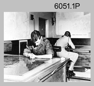 Bendigo Military Museum
Photograph - Retouching Reproduction Material at the Army Survey Regiment, c1960s, c1970s
... Cartographic Squadron’s Correcting Section, located in the Attic. Retouching mainly entailed the application of liquid opaque (Plumtree), commonly known as “duff” to cover blemishes such as scratches and spots on film negatives before photographic exposure. Retouching technicians also used specialised techniques such as “needling” to repair faults on the emulsion of map reproduction material...material at the Army Survey Regiment, Bendigo. The photographs were printed on photographic paper and are part of the Army Survey Regiment’s Collection. The photographs were scanned at 300 dpi. .1) - Photo, black & white, c1960s. unidentified personnel in Lithographic Squadron. .2) - Photo, black & white, c1960s. unidentified personnel in Lithographic Squadron. .3) - Photo, black & white, c1960s. unidentified personnel in Cartographic Squadron Attic. .4) - Photo, black & white, c1960s. unidentified personnel in Cartographic Squadron Attic. .5) - Photo, black & white, c1970s. ...SGT Bob Scaddan in Cartographic Squadron. Retouching Reproduction Material at the Army Survey Regiment Photograph Retouching Reproduction Material at the Army Survey Regiment Army Survey Regiment ...The first four photographs were most likely taken in the 1960 and the fifth in the 1970s at the Army Survey Regiment, Fortuna, Bendigo. As there are no annotations with the photos, the exact dates, locations and names of personnel are unknown. SGT Bob Scaddan appears in the fifth photo taken in the 1970s Photos .1P and .2P. could have been taken in Lithographic Squadron’s retouching room and Photos .3P, .4P and .5P. were probably taken in Cartographic Squadron’s Correcting Section, located in the Attic. Retouching mainly entailed the application of liquid opaque (Plumtree), commonly known as “duff” to cover blemishes such as scratches and spots on film negatives before photographic exposure. Retouching technicians also used specialised techniques such as “needling” to repair faults on the emulsion of map reproduction material. The technician in photo .4P is needling a hydrographic feature on a drainage negative, with a zoom transfer scope projecting a scaled projected aerial photograph as a positional reference. This is a set of five photographs of technicians retouching reproduction material at the Army Survey Regiment, Bendigo. The photographs were printed on photographic paper and are part of the Army Survey Regiment’s Collection. The photographs were scanned at 300 dpi. .1) - Photo, black & white, c1960s. unidentified personnel in Lithographic Squadron. .2) - Photo, black & white, c1960s. unidentified personnel in Lithographic Squadron. .3) - Photo, black & white, c1960s. unidentified personnel in Cartographic Squadron Attic. .4) - Photo, black & white, c1960s. unidentified personnel in Cartographic Squadron Attic. .5) - Photo, black & white, c1970s. SGT Bob Scaddan in Cartographic Squadron..1P to .3P, .5P - annotated “Retouching”royal australian survey corps, rasvy, army survey regiment, army svy regt, fortuna, asr, litho, carto -
 Bendigo Military Museum
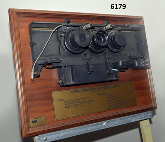
Plaque - Mounted Klimsch Commodore Cartographic Camera Lenses, WYCOMBE Constructions Pty Ltd, 1997
... Cartographic Camera that was located in Lithographic Squadron at the Army Survey Regiment, Fortuna, Bendigo. The KLIMSCH Commodore camera was originally introduced to the Survey Regiment in 1953 and was the largest in the Southern Hemisphere. It was replaced with a new model of the same size in 1977. These lenses are from this new model. The new model with its computer-based interface provided productivity gains with improved speed and its consistent results led to less wastage in time and materials...Cartographic Camera that was located in Lithographic Squadron at the Army Survey Regiment, Fortuna, Bendigo. The KLIMSCH Commodore camera was originally introduced to the Survey Regiment in 1953 and was the largest in the Southern Hemisphere. It was replaced with a new model of the same size in 1977. These lenses are from this new model. The new model with its computer-based interface provided productivity gains with improved speed and its consistent results led to less wastage in time and materials ...These are the Lenses from the Klimsch Commodore Cartographic Camera that was located in Lithographic Squadron at the Army Survey Regiment, Fortuna, Bendigo. The KLIMSCH Commodore camera was originally introduced to the Survey Regiment in 1953 and was the largest in the Southern Hemisphere. It was replaced with a new model of the same size in 1977. These lenses are from this new model. The new model with its computer-based interface provided productivity gains with improved speed and its consistent results led to less wastage in time and materials. Its variomat lens system provided improved retention of map feature linear weights during the camera reduction process. The camera which was specially made for the Australian Army in Germany was fully automatic and power operated. It was claimed to be one of the biggest automatic cameras of its type in the world. It was made to the specifications of the Royal Australian Army Survey Corps to assist in the production of the very high standard maps for the Australian Army. THIS KLIMSCH COMMODORE CARTOGRAPHIC CAMERA was in operation 1977 - 1997". It was a Precision Darkroom Camera especially suited for Cartographic Reproduction of Line, Continous Tone, Halftone and Colour Separation. Reproduction of Negatives and Positives from a variety of Reflection or Transmission Originals. Its characteristics were: Maximum Negative Size 1.27m sq, Copy Holder (Vacuum) 2m sq, Maximum Enlargement 400%, Maximum Reduction 13%, Automatic 60, 90 and 120cm Focal Length Lens, Transmission or Reflection Originals, Pulsed Xenon, Photo Flood or Fluorescent Tube Light Source, Maximum Reflection Original 1.3m x 1.85m, Maximum Transmission Original 1.3m x 1.85m, Exposure Light Monitoring System." The camera was superseded by computerized image manipulation software associated with the Automap system. These significant and extremely high-quality Lenses were retrieved by WYCOMBE Constructions Pty Ltd during the demolishment of the camera in 1997 and then mounted on a display board. See also Item 6189.4P for more photographs of the camera.Lenses from the Klimsch Commodore Cartographic Camera mounted on a very heavy timber display board. The display board contains an engraved plate that describes the technical characteristics of the camera."KLIMSCH COMMODORE CARTOGRAPHIC CAMERA 1977 - 1997", "FUNCTION: Precision Darkroom Camera especially suited for Cartographic Reproduction of Line, Continous Tone, Halftone and Colour Separation. Reproduction of Negatives and Positives from a variety of Reflection or Transmission Originals." "CHARACTERISTICS: Maximum Neg Size 1.27m sq, Copy Holder 2m sq, Maximum Enlargement 400%, Maximum Reduction 13%, Automatic 60, 90, 120cm Focal Length Lens, Transmission or Reflection Originals, Pulsed Xenon, Photo Flood or Fluorescent Tube Light Source, Maximum Reflection Original 1.3m x 1.85m, Maximum Transmission Original 1.3m x 1.85m, Exposure Light Monitoring System." royal australian survey corps, rasvy, fortuna, army survey regiment, army svy regt, asr, litho -
 Bendigo Military Museum
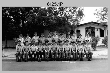
Photograph - Army Survey Regiment’s Officers, Warrant Officers and Sergeants and Squadrons, at Fortuna, Bendigo, 1982
... A component of the Army Svy Regt’s cartographic map production was carried out by the Detachment, a sub-unit located at Bonegilla next to the School of Military Survey. Lithographic Squadron was responsible for the reproduction of map materials and printing of military map products. ...A component of the Army Svy Regt’s cartographic map production was carried out by the Detachment, a sub-unit located at Bonegilla next to the School of Military Survey. Lithographic Squadron was responsible for the reproduction of map materials and printing of military map products. ...This is a set of six staff photographs of the Army Survey Regiment’s Officers, Warrant Officers and Sergeants, and each of its four Squadrons at Fortuna, Bendigo in December 1982. Note - Air Survey Squadron’s photo was probably taken in July 1982 as they appear in winter dress. Air Survey Squadron was responsible for aerotriangulation, photogrammetric feature extraction and the AUTOMAP 1 system. Typical tasks were flight planning the acquisition of aerial photography, pugging, mensuration and block adjustments, photogrammetric extraction of topographic features from aerial photography, digital feature editing, map compilation, operating the scanner/plotter, operating the AUTOMAP 1 system and computer programming by civilians. Cartographic Squadron was responsible for the production of the following military products: Joint Operation Graphics, small-scale RAAF Air Charts, large-scale topographic line maps and orthophotomaps. Cartographic technician tasks were scribing, compiling, retouching, masking, type setting, type stickup, terrain embossing, correcting and proving quality control. Headquarters Squadron was responsible for the planning and coordination of map production and contracts. It also performed administrative and support functions such as personnel administration, pay, finance, transportation, records, map Library, kitchens, messes and facility maintenance. It was staffed by Army personnel from RASvy, RACT, AACC, RAAOC and RAEME corps. Other supporting staff at this time included the RAAF Liaison Officer, RAN Liaison Officer and several civilians employed in administration, the Q-Store and grounds maintenance. A component of the Army Svy Regt’s cartographic map production was carried out by the Detachment, a sub-unit located at Bonegilla next to the School of Military Survey. Lithographic Squadron was responsible for the reproduction of map materials and printing of military map products. The main tasks undertaken by photographic technicians were photographic enlargements, reductions and duplication of map reproduction material and processing of aerial photography. Printing technician tasks included platemaking, offset printing, map stock despatching and proofing.This is a set of six staff photographs of the Army Survey Regiment’s Officers, Warrant Officers and Sergeants, and its four Squadrons, at Fortuna, Bendigo, 1982. The black and white photographs were printed on photographic paper and are part of the Army Survey Regiment’s Collection. The photograph was scanned at 300 dpi. No personnel are identified. No personnel are identified. .1P – Annotated on front “OFFICERS MESS DEC ’82” .2P – Annotated on back “SGTS MESS DEC ’82” .4P– Annotated on front “CARTO SQN DEC ’82” .5P– Annotated on front “HQ SQN DEC ’82”royal australian survey corps, rasvy, army survey regiment, army svy regt, fortuna, asr, air survey, carto, litho -
Bendigo Historical Society Inc.
Painting - FORTUNA COLLECTION: WATERCOLOUR OF FORTUNA VILLA
... Possibly used to develop promotional material for Department of Defence, Cartography section, then resident in Fortuna. ...Possibly used to develop promotional material for Department of Defence, Cartography section, then resident in Fortuna. ...Watercolour painting of Fortuna Villa. Lake in foreground, palm tree left hand side. Perspex sheet overlay with 'Fortuna' embellished in ornate font. Possibly used to develop promotional material for Department of Defence, Cartography section, then resident in Fortuna. Artist name on bottom right hand corner ' Bill Walls'bendigo, house, fortuna villa -
 Flagstaff Hill Maritime Museum and Village
Document - Map, Department of Lands & Survey, Victoria / Panmure, 1942
... Cartographic Company until 1955 when it became the A.H.Q. Survey Regiment. The W.R. Angus Collection includes historical medical equipment, surgical instruments and material once belonging to Dr Edward Ryan and Dr Thomas Francis Ryan, (both of Nhill, Victoria) as well as Dr Angus’ own belongings. ...Cartographic Company until 1955 when it became the A.H.Q. Survey Regiment. The W.R. Angus Collection includes historical medical equipment, surgical instruments and material once belonging to Dr Edward Ryan and Dr Thomas Francis Ryan, (both of Nhill, Victoria) as well as Dr Angus’ own belongings. ...This Emergency Edition of the map of Panmure, Victoria, is part of the W.R. Angus Collection. It was printed in 1942 during World War II. It is one of two maps donated to Flagstaff Hill Maritime Village by the family of Doctor William Roy Angus, who served as Surgeon Captain in the Australian Defence Department. The map was compiled for the Dept. of Army by the Dept. of Lands and Survey in Melbourne, prepared by the Australian Section of the Imperial General Staff, which was a British Government body created in 1907 to co-ordinate the defence of Britain and its Empire. It was printed by A.H.Q. Cartographic Company, Survey Corps, which was formed in 1941. The Corp changed its name to L.H.Q. Cartographic Company of Bendigo. In 1947 the name reverted back to the A.H.Q. Cartographic Company until 1955 when it became the A.H.Q. Survey Regiment. The W.R. Angus Collection includes historical medical equipment, surgical instruments and material once belonging to Dr Edward Ryan and Dr Thomas Francis Ryan, (both of Nhill, Victoria) as well as Dr Angus’ own belongings. The Collection’s history spans the medical practices of the two Doctors Ryan, from 1885-1926 plus that of Dr Angus who began practice in 1924. Dr. Angus served with the Australian Department of Defence as a Surgeon Captain during the Second World Was from 1942 to 1945. He served in Ballarat, Victoria, and in Bonegilla, N.S.W. until he suffering from a heart attack just before the war ended. ABOUT THE “W.R.ANGUS COLLECTION” - Doctor William Roy Angus M.B., B.S., Adel., 1923, F.R.C.S. Edin.,1928, was generally known as Dr Roy Angus. His working life included a position as a doctor with the Flying Doctor Service in Australia’s rural and remote areas. After many varied experiences Dr Angus and his family moved to Warrnambool in 1939 where he purchased “Birchwood,” the 1852 home and medical practice of Dr John Hunter Henderson. He was appointed on a part-time basis as Port Medical Officer in Warrnambool and held this position until the 1940’s when the government no longer required the service of a Port Medical Officer. Dr Angus was a surgeon at the Warrnambool Base Hospital 1939-1942. After further studies he commenced practice as an ophthalmologist in Warrnambool, pioneering in artificial eye improvements. He was Honorary Consultant Ophthalmologist to Warrnambool Base Hospital for 31 years and made monthly visits to Portland to perform eye surgery. Dr Angus and his wife Gladys were very involved in Warrnambool’s community with a strong interest in civic affairs. They were both involved in the creation of Flagstaff Hill Maritime Village, including the layout of the gardens. After his death on 28th March 1970 his family requested his practitioner’s plate, medical instruments and some personal belongings be displayed in the Port Medical Office surgery at Flagstaff Hill Maritime Village, and be called the “W. R. Angus Collection”. This Emergency Edition of the Map of Panmure is significant as an example of the documents prepared for the defence of Australia in World War 2. The Map is also significant for its connection between the Australian Army and the involvement of Dr WR Angus as a Surgeon in the Medical Services during World War II. The W.R. Angus Collection is significant for still being located at the site it is connected with, Doctor Angus being the last Port Medical Officer in Warrnambool. The collection of medical instruments and other equipment is culturally significant, being an historical example of medicine, administration, household equipment and clothing from late 19th to mid-20th century. Dr Angus assisted Dr Tom Ryan, a pioneer in the use of X-rays and in ocular surgery. The collection includes Dr Angus’s Army objects and is significant as an example of items issued to Doctors and Surgeons in the Medical Services of the Australian Army in World War IIMilitary map of Panmure, Victoria, Australia; part of the W.R. Angus Collection. Rectangular coloured map on cream paper for the Australian Army. Details include sea, waterways and land, contour lines, grid lines, names of districts, towns and roads, bridges, swamps, rail lines, cuttings, tracks, buildings (including blacksmiths), pumps, lighthouses, telegraph, telephones and electric transmission lines, and fire stations. The map has margin notes that include distances in miles to nearby towns. The map was compiled for the Dept. of Army by the Dept. of Lands and Survey in Melbourne, prepared by the Australian Section, Imperial General Staff and printed by A.H.Q. Cartographic Company, Melbourne in 1942. Crown Copyright Reserved. Inscriptions in red print state that it is and Emergency Edition and an Official document. An oval purple stamp includes the price.Printed in black; 'Victoria / Panmure", "No. 930 / Zone 6" Printed in red; “EMERGENCY EDITION”, “THIS MAP IS AN OFFICIAL DOCUMENT. IF FOUND, IT MUST BE HANDED / IN TO THE NEAREST MILITARY HEADQUARTERS OR POLICE STATION” Stamped: within concentric ovals (“- - - FOR SALE / PRICE 2/- / - - - - - OF THE ARMY”)flagstaff hill, warrnambool, flagstaff hill maritime museum, maritime museum, shipwreck coast, flagstaff hill maritime village, great ocean road, dr w r angus, dr ryan, warrnambool base hospital, flying doctor, surgeon captain, australian department of defence, royal australian army, world war 2, map panmure 1942, roy angus, port medical officer, nhill base hospital, military map, emergency map, military service australian army, department of army, department of lands and survey, a.h.q. cartographic company melbourne, panmure 1942, australian section, imperial general staff -
 Flagstaff Hill Maritime Museum and Village
Document - Map, Department of Lands & Survey, Victoria / Port Campbell, 1942
... Cartographic Company until 1955 when it became the A.H.Q. Survey Regiment. The W.R. Angus Collection includes historical medical equipment, surgical instruments and material once belonging to Dr Edward Ryan and Dr Thomas Francis Ryan, (both of Nhill, Victoria) as well as Dr Angus’ own belongings. ...Cartographic Company until 1955 when it became the A.H.Q. Survey Regiment. The W.R. Angus Collection includes historical medical equipment, surgical instruments and material once belonging to Dr Edward Ryan and Dr Thomas Francis Ryan, (both of Nhill, Victoria) as well as Dr Angus’ own belongings. ...This Emergency Edition of the map of Port Campbell, Victoria, is part of the W.R. Angus Collection. It was printed in 1942 during World War II. It is one of two maps donated to Flagstaff Hill Maritime Village by the family of Doctor William Roy Angus, who served as Surgeon Captain in the Australian Defence Department. The map was compiled for the Dept. of Army by the Dept. of Lands and Survey in Melbourne, prepared by the Australian Section of the Imperial General Staff, which was a British Government body created in 1907 to co-ordinate the defence of Britain and its Empire. It was printed by A.H.Q. Cartographic Company, Survey Corps, which was formed in 1941. The Corp changed its name to L.H.Q. Cartographic Company of Bendigo. In 1947 the name reverted back to the A.H.Q. Cartographic Company until 1955 when it became the A.H.Q. Survey Regiment. The W.R. Angus Collection includes historical medical equipment, surgical instruments and material once belonging to Dr Edward Ryan and Dr Thomas Francis Ryan, (both of Nhill, Victoria) as well as Dr Angus’ own belongings. The Collection’s history spans the medical practices of the two Doctors Ryan, from 1885-1926 plus that of Dr Angus who began practice in 1924. Dr Angus served with the Australian Department of Defence as a Surgeon Captain during the Second World Was from 1942 to 1945. He served in Ballarat, Victoria, and in Bonegilla, N.S.W. until he suffering from a heart attack just before the war ended. ABOUT THE “W.R.ANGUS COLLECTION” - Doctor William Roy Angus M.B., B.S., Adel., 1923, F.R.C.S. Edin.,1928, was generally known as Dr Roy Angus. His working life included a position as a doctor with the Flying Doctor Service in Australia’s rural and remote areas. After many varied experiences Dr Angus and his family moved to Warrnambool in 1939 where he purchased “Birchwood,” the 1852 home and medical practice of Dr John Hunter Henderson. He was appointed on a part-time basis as Port Medical Officer in Warrnambool and held this position until the 1940’s when the government no longer required the service of a Port Medical Officer. Dr Angus was a surgeon at the Warrnambool Base Hospital 1939-1942. After further studies he commenced practice as an ophthalmologist in Warrnambool, pioneering in artificial eye improvements. He was Honorary Consultant Ophthalmologist to Warrnambool Base Hospital for 31 years and made monthly visits to Portland to perform eye surgery. Dr Angus and his wife Gladys were very involved in Warrnambool’s community with a strong interest in civic affairs. They were both involved in the creation of Flagstaff Hill Maritime Village, including the layout of the gardens. After his death on 28th March 1970 his family requested his practitioner’s plate, medical instruments and some personal belongings be displayed in the Port Medical Office surgery at Flagstaff Hill Maritime Village, and be called the “W. R. Angus Collection”. This Emergency Edition of the Map of Port Campbell is significant as an example of the documents prepared for the defence of Australia in World War 2. The Map is also significant for its connection between the Australian Army and the involvement of Dr WR Angus as a Surgeon in the Medical Services during World War II. The W.R. Angus Collection is significant for still being located at the site it is connected with, Doctor Angus being the last Port Medical Officer in Warrnambool. The collection of medical instruments and other equipment is culturally significant, being an historical example of medicine, administration, household equipment and clothing from late 19th to mid-20th century. Dr Angus assisted Dr Tom Ryan, a pioneer in the use of X-rays and in ocular surgery. The collection includes Dr Angus’s Army objects and is significant as an example of items issued to Doctors and Surgeons in the Medical Services of the Australian Army in World War IIMilitary map of Port Campbell, Victoria, Australia; part of the W.R. Angus Collection. Rectangular coloured map on cream paper for the Australian Army. Details include sea, waterways and land, contour lines, grid lines, names of districts, towns and roads, bridges, swamps, rail lines, cuttings, tracks, buildings (including blacksmiths), pumps, lighthouses, telegraph, telephones and electric transmission lines, and fire stations. The map has margin notes that include distances in miles to nearby towns. The map was compiled for the Dept. of Army by the Dept. of Lands and Survey in Melbourne, prepared by the Australian Section, Imperial General Staff and printed by A.H.Q. Cartographic Company, Melbourne in 1942. Crown Copyright Reserved. Inscriptions in red print state that it is and Emergency Edition and an Official document. An oval purple stamp includes the price.Printed in black; 'Victoria / Port Campbell", "No. 932 / Zone 6" Printed in red; “EMERGENCY EDITION”, “THIS MAP IS AN OFFICIAL DOCUMENT. IF FOUND, IT MUST BE HANDED / IN TO THE NEAREST MILITARY HEADQUARTERS OR POLICE STATION” Stamped: within concentric ovals (“- - - FOR SALE / PRICE 2/- / - - - - - OF THE ARMY”)flagstaff hill, warrnambool, flagstaff hill maritime museum, maritime museum, shipwreck coast, flagstaff hill maritime village, great ocean road, dr w r angus, dr ryan, warrnambool base hospital, nhill base hospital, flying doctor, surgeon captain, map port campbell 1942, roy angus, port medical officer, military map, emergency map, australian department of defence, royal australian army, military service australian army, department of army, department of lands and survey, world war 2, a.h.q. cartographic company melbourne, australian section, imperial general staff, port campbell 1942 -
 City of Moorabbin Historical Society (Operating the Box Cottage Museum)
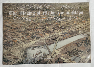
Book, Leeuwenburg, Jeff, The making of Melbourne in maps, 1987
... City of Moorabbin Historical Society (Operating the Box Cottage Museum) Joyce Park Jasper Road Ormond melbourne maps Melbourne Cartographic material. 1 atlas (57 p.) : ill., chiefly maps ; The making of Melbourne in maps Book Leeuwenburg, Jeff Longman Cheshire ...Cartographic material.1 atlas (57 p.) : ill., chiefly maps ;Cartographic material.maps, melbourne -
 Kew Historical Society Inc
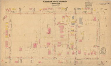
Plan, Melbourne & Metropolitan Board of Works : Borough of Kew : Detail Plan No.1576, 1904
... materials so that the maps in this collection are invaluable and unique tools for researchers and heritage consultants. A number of the plans are not held in the collection of the State Library of Victoria so they have the additional attribute of rarity. melbourne and metropolitan board of works, detail plans maps - borough of kew mmbw 1576 cartography Original survey plan, issued by the MMBW to a contractor with responsibility for constructing sewers in the area identified on the plan within the Borough of Kew. ...The Melbourne and Metropolitan Board of Works (MMBW) plans were produced from the 1890s to the 1950s. They were crucial to the design and development of Melbourne's sewerage and drainage system. The plans, at a scale of 40 feet to 1 inch (1:480), provide a detailed historical record of Melbourne streetscapes and environmental features. Each plan covers one or two street blocks (roughly six streets), showing details of buildings, including garden layouts and ownership boundaries, and features such as laneways, drains, bridges, parks, municipal boundaries and other prominent landmarks as they existed at the time each plan was produced. (Source: State Library of Victoria)This plan forms part of a large group of MMBW plans and maps that was donated to the Society by the Mr Poulter, City Engineer of the City of Kew in 1989. Within this collection, thirty-five hand-coloured plans, backed with linen, are of statewide significance as they include annotations that provide details of construction materials used in buildings in the first decade of the 20th century as well as additional information about land ownership and usage. The copies in the Public Record Office Victoria and the State Library of Victoria are monochrome versions which do not denote building materials so that the maps in this collection are invaluable and unique tools for researchers and heritage consultants. A number of the plans are not held in the collection of the State Library of Victoria so they have the additional attribute of rarity.Original survey plan, issued by the MMBW to a contractor with responsibility for constructing sewers in the area identified on the plan within the Borough of Kew. The plan was at some stage hand-coloured, possibly by the contractor, but more likely by officers working in the Engineering Department of the Borough and later Town, then City of Kew. The hand-coloured sections of buildings on the plan were used to denote masonry or brick constructions (pink), weatherboard constructions (yellow), and public buildings (grey). Development in the 20th century has irreparably altered that part of Kew represented in this plan. In the block bounded by Cotham Road, Charles Street, Wellington Street and Gellibrand; just one house standing in 1903 remains. This block included two of the most historic houses in Kew: ‘Ordsall’ (later ‘Southesk’) and ‘Madford’ (previously ‘Elm Lodge’). Ordsall was the home of the second chairman of Kew, John Halfey. It contained some of the most significant interior murals in Kew, created for Halfey by artists working for Cullen & Co. It was demolished in 1960 to make way for the Kew Civic Centre. Elm Lodge had been built for William Siddeley in ca. 1864. Arthur Septimus King purchased it in 1874. The lower paddocks of Madford were sold in 1905 by his wife to the Borough of Kew and, after landscaping by George and Thomas Pockett, opened as the Alexandra Gardens in 1908. Elm Lodge/Madford was in 1922 to become St. Anthony’s Home for Little Children before its subsequent demolition in the 1980s.melbourne and metropolitan board of works, detail plans, maps - borough of kew, mmbw 1576, cartography -
 Kew Historical Society Inc
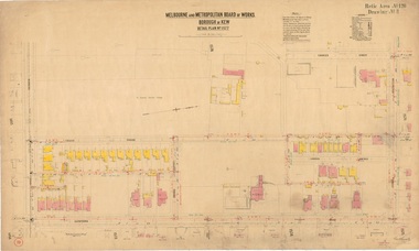
Plan, Borough of Kew Detail Plan No.1577, 1904
... materials so that the maps in this collection are invaluable and unique tools for researchers and heritage consultants. A number of the plans are not held in the collection of the State Library of Victoria so they have the additional attribute of rarity. melbourne and metropolitan board of works, detail plans maps - borough of kew mmbw 1577 cartography Original survey plan, issued by the MMBW to a contractor with responsibility for constructing sewers in the area identified on the plan within the Borough of Kew. ...The Melbourne and Metropolitan Board of Works (MMBW) plans were produced from the 1890s to the 1950s. They were crucial to the design and development of Melbourne's sewerage and drainage system. The plans, at a scale of 40 feet to 1 inch (1:480), provide a detailed historical record of Melbourne streetscapes and environmental features. Each plan covers one or two street blocks (roughly six streets), showing details of buildings, including garden layouts and ownership boundaries, and features such as laneways, drains, bridges, parks, municipal boundaries and other prominent landmarks as they existed at the time each plan was produced. (Source: State Library of Victoria)This plan forms part of a large group of MMBW plans and maps that was donated to the Society by the Mr Poulter, City Engineer of the City of Kew in 1989. Within this collection, thirty-five hand-coloured plans, backed with linen, are of statewide significance as they include annotations that provide details of construction materials used in buildings in the first decade of the 20th century as well as additional information about land ownership and usage. The copies in the Public Record Office Victoria and the State Library of Victoria are monochrome versions which do not denote building materials so that the maps in this collection are invaluable and unique tools for researchers and heritage consultants. A number of the plans are not held in the collection of the State Library of Victoria so they have the additional attribute of rarity.Original survey plan, issued by the MMBW to a contractor with responsibility for constructing sewers in the area identified on the plan within the Borough of Kew. The plan was at some stage hand-coloured, possibly by the contractor, but more likely by officers working in the Engineering Department of the Borough and later Town, then City of Kew. The hand-coloured sections of buildings on the plan were used to denote masonry or brick constructions (pink), weatherboard constructions (yellow), and public buildings (grey). MMBW Plan No.1577 includes some of the most significant houses in Kew: Herbert Henty’s ‘Roxeth’ (now part of Trinity Grammar), ‘Butleigh Wooton’, ‘Bokara’ and ‘Harrow’. It also includes the streets that have since changed their names. That part of College Parade linked to Glenferrie Road is now named College Place, College Parade now extends further north, and Charles Street did not yet reach Barkers Road. Roxeth is one of a number of Henty houses in Kew. Herbert Henty made his home here and was elected a member of Kew Municipal Council in 1864 and mayor in 1868-69. Walter Henry Serle, of Harrow served in the First World War. He was awarded the Military Medal ‘’For conspicuous bravery and devotion to duty. On 29th September near BELLICOURT he showed the greatest bravery and determination when his platoon was attacked by enemy bombing parties. It was due largely to his personal efforts that all the attacks were repulsed. Until wounded, his utter disregard of personal safety and boldness in dealing with the attacks were the means of saving the situation and were an inspiring example to his men.’melbourne and metropolitan board of works, detail plans, maps - borough of kew, mmbw 1577, cartography