Showing 3816 items matching crown
-
 Federation University Historical Collection
Plan, Haddon, County of Grenville, 1932, 13/04/1932
The Haddon Parish Plan shows crown parcels government roads, Crown Reserves, Railway. Scale 40 chains to 1" (1:31, 680) WGS 84 Centroid Lat: 37 degrees 34' 00" S Long: 148 degrees 40' 20" E N.S. 9.3km E.W.: 16.1kmhaddon, grenville, cardigan, water supply reserve, nentingbook pre-emptive right, a. mclachlan, lake burrumbeet, e.a. wynne, p. russell, b. hepburn, benjamin hepburn, nentingbool, t.c. wilson, j. amoy, william collard smith, james roach, j. mitchell -
 Buninyong & District Historical Society
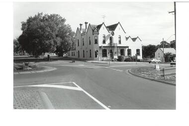
Photograph - B/W photograph, Mr. C.J.Brooks, Crown Hotel Buninyong, cnr. Warrenheip and Learmonth Streets, 1993
Original wooden hotel built 1852, burnt down 1884 and replaced by current brick building.Licensed premises since gold rushB/W photo of Crown Hotel, Buninyong, two-story, gabled hotel, brick painted white, viewed across intersection, large Chinese Elm tree to left, which was destroyed in truck accident 6 May 2022.buninyong, crown hotel, building, streetscape, chinese elm -
 Bayside Gallery - Bayside City Council Art & Heritage Collection
Photograph, Department of Crown Lands and Survey, Victoria, Melbourne Project: Brighton, 1976
The Department of Crown Lands and Survey (1857-1983) was responsible for the administration of survey and mapping and the sale, occupation and management of crown land throughout its existence. This aerial photograph shows parts of Brighton and was taken on 1 December 1976brighton, department of crown lands and survey, aerial photograph, bayside, port phillip bay, map, cartographic material, melbourne project 1976, brighton yacht club, middle brighton baths, north road, st kilda street, new street -
 Victorian Harness Racing Heritage Collection at Lord's Raceway Bendigo
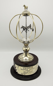
Memorabilia - Silver trophy, Maori's Crown, 1998 Vicbred Super Series Final 2yo trotters
Maori's Crown (The Contender Imp P 1.54.0 - Maori Mara Vic Tr 2.9.2 (Bravado Hanover)) Bay Mare. Foaled 1995 (9th Foal). Breeder/Owner: R McD Healy & Co Pty Ltd. Trainer: R McD Healy. Maori's Crown raced from 1998 (2yo) through to 2001 (5yo). Career: 8 wins 1 second 5 thirds 32 starts $57,060 2.06.2 Winning Drivers: BR Gath (4) BR Healy (3) MN Wishart (1). Won on 4 Tracks: Moonee Valley (5) Bendigo (1) Maryborough (1) Ballarat (1)Maori's Crown won the 1998 Vicbred Super Series Final 2yo Trotters at Moonee Valley over 1940m at a mile rate of 2.10.7. Driven by BR Gath. Defeating Claes 2nd and Mad Azz 3rd.Gold and Silver Trophy on a Wooden BaseVicbred / Super Series / Final / 2yo Trotters / Moonee Valley / Saturday 11 July 1998 / Won bytrotting, maoris crown, moonee valley, vicbred super series, 1998, ric healy, r healy, br healy, bryan healy, br gath, brian gath, b gath, b healy, r mcd healy -
 Victorian Harness Racing Heritage Collection at Lord's Raceway Bendigo
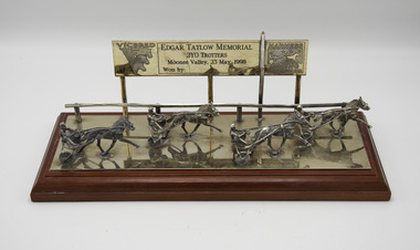
Memorabilia - Glass trophy, Maori's Crown, 1998 Edgar Tatlow Memorial 2yo Trotters
Maori's Crown (The Contender Imp P 1.54.0 - Maori Mara Vic Tr 2.9.2 (Bravado Hanover)) Bay Mare. Foaled 1995 (9th Foal). Breeder/Owner: R McD Healy & Co Pty Ltd. Trainer R McD Healy. Maori's Crown raced from 1998 (2yo) through to 2001 (5yo). Career: 8 wins 1 second 5 thirds 32 starts $57,060 2.06.2 Winning Drivers: BR Gath (4) BR Healy (3) MN Wishart (1). Won on 4 Tracks: Moonee Valley (5) Bendigo (1) Maryborough (1) Ballarat (1)Maori's Crown won the 1998 Edgar Tatlow Memorial 2yo Trotters at Moonee Valley over 1940m at a mile rate of 2.06.3. Driven by BR Gath. Defeating Heza Joule 2nd and Kellybrooke 3rd.Glass plaqueVicbred /Edgar Tatlow Memorial / 2yo Trotters / Moonee Valley 23 May 1998 / Won by / Harness Racing Victoria Designed and Handcrafted / in Australia by / Renown Silverwaretrotting, edgar tatlow, moonee valley, 1998, ric healy, r healy, br gath, brian gath, br healy, bryan healy, b gath, b healy, r mcd healy -
 Bayside Gallery - Bayside City Council Art & Heritage Collection
Photograph, Department of Crown Lands and Survey, Victoria, Melbourne Project: Brighton and Elwood, 1976
The Department of Crown Lands and Survey (1857-1983) was responsible for the administration of survey and mapping and the sale, occupation and management of crown land throughout its existence. This aerial photograph shows parts of Brighton and Elwood and was taken on 1 December 1976brighton, elwood, department of crown lands and survey, aerial photograph, elsternwick park, point ormond, north road, ormond esplanade, st kilda street, glen huntly road, bayside, port phillip bay, map, cartographic material, melbourne project 1976 -
 Bayside Gallery - Bayside City Council Art & Heritage Collection
Photograph, Department of Crown Lands and Survey, Victoria, Melbourne Project: Brighton and Hampton, 1976
The Department of Crown Lands and Survey (1857-1983) was responsible for the administration of survey and mapping and the sale, occupation and management of crown land throughout its existence. This aerial photograph shows parts of Brighton and Hampton and was taken on 1 December 1976. brighton, department of crown lands and survey, aerial photograph, bayside, port phillip bay, map, cartographic material, melbourne project 1976, brighton yacht club, middle brighton baths, hampton, green point, brighton beach, south road, the esplanade, hampton street -
 Bayside Gallery - Bayside City Council Art & Heritage Collection
Photograph, Department of Crown Lands and Survey, Victoria, Brighton, Brighton East and Bentleigh, c. 1965-71
The Department of Crown Lands and Survey (1857-1983) was responsible for the administration of survey and mapping and the sale, occupation and management of crown land throughout its existence. This aerial photograph shows parts of Brighton and Brighton East and was taken circa 1965-71.brighton, department of crown lands and survey, aerial photograph, bayside, port phillip bay, map, cartographic material, brighton east, dendy park, dendy street, centre road, nepean highway, south road, brighton golf course, golf -
 Bayside Gallery - Bayside City Council Art & Heritage Collection
Photograph, Department of Crown Lands and Survey, Victoria, Brighton, Elwood and Elsternwick, c. 1965-71
The Department of Crown Lands and Survey (1857-1983) was responsible for the administration of survey and mapping and the sale, occupation and management of crown land throughout its existence. This aerial photograph shows parts of Brighton, Elwood and Elsternwick and was taken circa 1965-71.brighton, department of crown lands and survey, aerial photograph, bayside, port phillip bay, map, cartographic material, elwood, elsternwick, elsternwick park, elwood tram depot, elwood pier, new street, glen huntly road, st kilda street, nepean highway -
 Bayside Gallery - Bayside City Council Art & Heritage Collection
Photograph, Department of Crown Lands and Survey, Victoria, Melbourne Project: Brighton, Hampton, Sandringham, 1976
The Department of Crown Lands and Survey (1857-1983) was responsible for the administration of survey and mapping and the sale, occupation and management of crown land throughout its existence. This aerial photograph shows parts of Brighton, Hampton and Sandringham and was taken on 1 December 1976brighton, department of crown lands and survey, aerial photograph, bayside, port phillip bay, map, cartographic material, hampton, sandringham, green point, sandringham yacht club, south road, beach road, hampton street, melbourne project 1976 -
 Bayside Gallery - Bayside City Council Art & Heritage Collection
Photograph, Department of Crown Lands and Survey, Victoria, Brighton, Brighton East and Bentleigh, c. 1965-71
The Department of Crown Lands and Survey (1857-1983) was responsible for the administration of survey and mapping and the sale, occupation and management of crown land throughout its existence. This aerial photograph shows parts of Brighton, Brighton East and Bentleigh and was taken circa 1965-71.brighton, department of crown lands and survey, aerial photograph, bayside, port phillip bay, map, cartographic material, bentleigh, brighton east, dendy park, dendy street, centre road, nepean highway, south road, football -
 Buninyong & District Historical Society
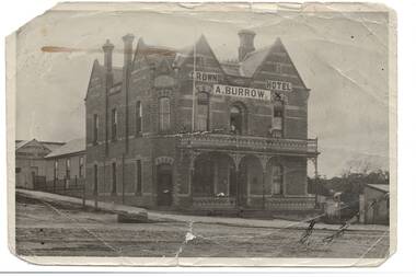
Photograph - Original Photograph, Crown Hotel, Buninyong, from Learmonth St. around 1905, around 1905
gold rush era historic building, social historyB/W photo, Crown Hotel, Buninyong, from Learmonth St. around 1905, shows some adjoining buildings inc. Caffrey's Shoeing Forge. Clearly shows original polychrome brickwork, full width iron lace veranda and tall flagpole.buninyong, crown hotel, learmonth st., warrenheip st, caffrey's shoeing forge -
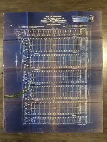 Whittlesea Historical Society Inc.
Map, Plan of Subdivision of Part of Crown Section 25, at Thomastown, Parish of Keelbundora, County of Bourke
Plan of Subdivision of Part of Crown Section 25, at Thomastown, Parish of Keelbundora, County of Bourke Epping Road, Mount View Road, Tramoo St, Hurtle St, Arndell St, Travers St, Westall St, Chappell St, and Pleasant Road, recorded on the map.Blue sheet. Aged sticky tape on map. Map 6 of 20 in green folder. Shows subdivision of blocks numbered 1 - 340, sizes of the blocks, and names of the surrounding streets. LP 13050. Undated.map, subdivision map, thomastown map, thomastown, epping road, mount view road, tramoo street, hurtle street, arndell street, travers street, westall street, chappell street, pleasant road -
 Ringwood and District Historical Society
Document - Land Title, John Quinlan et al, Land title (Ringwood) and correspondence between George Pratt of Nunawading and the Commissioner of Crown Lands 1869-1877, 1869
Land title and correspondence between George Pratt and the Commissioner of Crown Lands and Survey dated 19th(?) August 1869. Numbered 16678 (1M) plus 20 pages marked 42M-61M +Additional Keywords: Commissioner of Land and Survey / Longmare, Mr. / Quinlan, John -
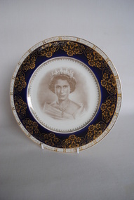 Anglesea and District Historical Society
Plate, Crown Ducal, 1954
Souvenir Queen Elizabeth 2 plate. Transfer printed head of monarch in centre of plate (sepia tone). Royal blue border with gold floral design on top. Some scratch marks - evidence of use.Back: Made Specially / By / Crown Ducal / Made in / England / to / Commemorate / Royal Tour Australia 1954 / Made in / England / A.G.R.queen elizabeth 2, royal tour australia 1954, crown ducal -
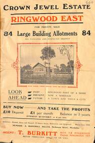 Ringwood and District Historical Society
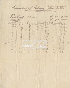
Flyer, Subdivisional Land Sale Brochure, Crown Jewel Estate, Ringwood East, Vic. - c.1925
In May 1884, George Smart of Bulleen Road Kew, brickmaker, bought the 23 acres one rood and twenty nine and three tenths perches, or 9.4834 hctares from Arthur Bailey Clements of Ringwood for the sum of 600 pound sterling. (Extract from The Story of the Crown Jewel Estate in Ringwood East pdf)Double sided folded page with black and red print on both sides advertising auction sale of residential and business sites and highlighting local facilities, services and layout of the estate.Subdivision includes Mount Dandenong Road, Valda Avenue, Evon Avenue, Mirabel Avenue, and Velma Grove. (Agent) T. Burkitt, Box 12 Ringwood, Phone Ringwood 157. Vendor: A. Marshall Miller, McDonald Street, Mordialloc. Solicitors: Russell, Bona and Russell, 19 Queen Street Melbourne, and Ringwood - Phone Cent. 4308. -
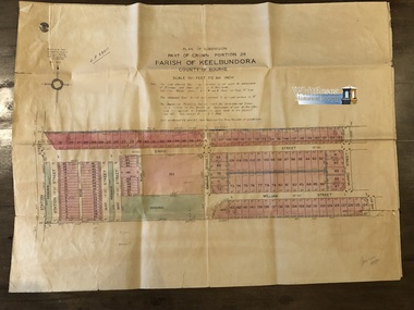 Whittlesea Historical Society Inc.
Map, Gulliver & Sim, Licensed Surveyors, Plan of Subdivision of Part of Crown Portion 26, Parish of Keelbundora, County of Bourke, c. 1953
Subdivision of Part of Crown Portion 26, Lalor, Vic. Map 1: Station St, David St, William St, May St, French St and Dalton Road. Map 2: David St, William St, Munro St, Jean St, Lorne St, Plane St, Ash St and Dalton Road. Messmate Street, Cyprus Street, Ash Street, Maple Street and Daltons Road recorded on the map.Two sheets, attached. The maps are fragile and have tears along the fold lines. Map 1. shows subdivision of blocks numbered 19 - 124, sizes of the blocks, and names of the surrounding streets. Map 2. shows subdivision of blocks numbered 19 - 124, sizes of the blocks, and names of the surrounding streets. Map 5 of 20 in green folder. Map 1. LP 29211. Map 2. LP 29212. Both maps, Sealed 13 May 1953. Gulliver & Sim, Licensed Surveyors, 15 Lorrean Avenue, East Brighton. S6. Tel. X54780.map, subdivision map, lalor, plane street, lalor map, ash street, david street, william street, may street, french street, dalton road -
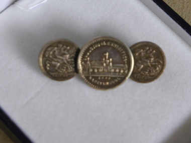 Warrnambool and District Historical Society Inc.
Tie Pin, Tie Pin half crown, Late 19th century
This tie pin has as its centerpiece a souvenir medal from the Warrnambool Industrial and Art Exhibition of 1896-7. This exhibition was held in the Town Hall and Council Buildings and the Mechanics’ Institute and temporary buildings at the corner of Liebig and Timor Streets, Warrnambool. It was held over three months and attracted many visitors and featured concerts, sports events, industrial exhibits and a variety of competitions. This is an interesting and important item. It is one of the more unusual mementoes from the Warrnambool Industrial and Art Exhibition and shows the use made of souvenirs from exhibitions around the world. This tiepin was purchased in an antique shop in England in the 20th century. This is a metal tie pin with three circular coins, soldered together at the edges. In the middle is a souvenir medal of the Warrnambool Industrial and Art Exhibition of 1896-7 showing an image of the Exhibition buildings at the corner of Timor and Liebig Streets on one side and a Coat of Arms on the other side. The two smaller coins on each side are imitation British half crowns. The clip at the back is soldered on to the two smaller coins Medal: Industrial Exhibition, Warrnambool 1896 Coins: 1889-90 warrnambool industrial and art exhibition 1896-7, warrnambool, tie pin -
 Melbourne Tram Museum
Drawing, "Plan of Survey of Part of Crown Allotments 15 and 16 at Hawthorn, Parish of Boroondara, County of Bourke", 1922
Drawing, coloured with water based drawing wash, titled "Plan of Survey of Part of Crown Allotments 15 and 16 at Hawthorn, Parish of Boroondara, County of Bourke". Shows the tram track, Wallen Road, changes around the intersection with Power St, buildings. A note at the bottom notes who owns what - MMTB and City of Hawthorn. Prepared by H. S. McComb, licensed Surveyor 6-9-1922. Stored folded.Stamped "Drawing Office" "Office Copy" and in red pencil "Hawthorn" in the bottom right hand corner, and on the rear "Drawing Office" "Office Copy" and "Hawthorn Depot" in pencil.trams, tramways, htt, mmtb, hawthorn depot, plans -
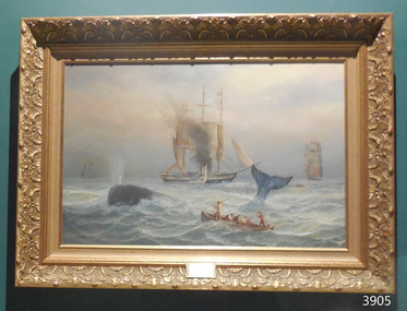 Flagstaff Hill Maritime Museum and Village
Painting - Oil painting, John Dollery, The Chase, c. 1980s
This painting shows a historic depiction of Australian whalers in action at sea, and shows the scale of man to whale. Whaling was one of the first industries in early Victoria. John Dollery was born in London in 1933. As a child he loved to draw and was a frequent visitor to the National and Tate Galleries. In 1957 Dollery came to Australia, settling in Queensland in 1965. After receiving a prize in a drawing exhibition, he began painting in oils, and is entirely self-taught. Whilst in Queensland he painted most of his canvases strictly from life and in 1977 he moved to Melbourne where he established himself as a full-time artist. John was very interested in Australia’s history, and most of his work represents this theme. Many of his pieces are in collections both in Australia and overseas. Dollery’s daughter is also an artist and has exhibited both her father's and her own works together in an exhibition 'Now and Then, Father and Daughter'.The painting is a significant work by artist John Dollery. Its subject of whaling shows an early Australian industry and shows the scale of man to whale. The decorative frame is appropriate for the era in which the scene would have taken place.Painting in oil on canvas, in gilt carved timber frame. Seascape, depicting a whale hunt. A spouting whale is behind a whale boat with six whalers aboard. A tall ship with seamen aboard is behind the whale. Two other tall ships and another whale boat are in background. An embossed plaque in bottom centre of lower frame has inscription.. Artist is J. Dollery. Stamped on the sticker “John Dollery / ARTIST / Crown Lot 16 The Esplanade Corinella, Victoria 3984 / Telephone: (056) 78 0644 “ Hand written on sticker “THE CHASE $xxx” Embossed in the wooden frame “30 / ART / Specturm” Signed “J DOLLERY”flagstaff hill, warrnambool, shipwrecked coast, flagstaff hill maritime museum, maritime museum, shipwreck coast, flagstaff hill maritime village, great ocean road, whales, whaling, industry, whale oil, blubber, john dollery, the chase, corinella, historic art work, australian art work, australian historic artwork -
 Federation University Historical Collection
Plan, Plan of Survey Crown Allotment 9A and Part of Crown Allotment 8 Section 10 City and Parish of Ballaarat, after 1929
ink and watercolor on watermarked laid paper dated 1928text and measurementsballaraat, ballarat, plan, plan of survey, armstrong street, skipton street -
University of Melbourne, Burnley Campus Archives
Document, Crown Grant Land Description Crown Alltoment 16R Parish of Jika Jika, 1994-2007
Photocopies of Title documentscrown land, allotment, jika jika -
Stawell Historical Society Inc
Archive, Crown Cross Reef Gold Mine Co & Extended Crown Cross, Share Register, 1868
Listing NamesHand Writtenstawell, mining -
 Mont De Lancey
Book, J F Ostervald et al, Le Nouveau Testament De Notre Seigneur Jesus - Christ, 1837
An antique copy of the New Testament in French.Brown marbled hardcover book of a French translation of the New Testament, Le Nouveau Testament De Notre Seigneur Jesus - Christ. No title on front cover or spine.non-fictionAn antique copy of the New Testament in French.religion, new testament -
 Eltham District Historical Society Inc
Document - Folder, Greensborough Railway Station Estate, Lots 26, 26A and 26B, Crown Portion 3, Parish of Nillumbik, County of Evelyn (Rattray Road, Montmorency)
Crown Portion 3 of Eltham, Parish of Nillumbik, County of Evelyn, Lots 26, 26A and 26B were part of the Greensborough Railway Station Estate. The land detailed is bounded by present-day Rattray Road, Reichelt Avenue, Wooded Way and Ryrie Court, Montmorency. Originally purchased in September 1913 by George William Miller, signwriter of Greensborough and Harry Frederick Miller, the land was sold to Mrs Margaret Barr Honeyman, 24 June 1918 on mortgage for £400, deposit paid £150. In February 1920, Mr Honeyman called for the title and paid off the loan early, settlement occuring 11 October 1920. Contents: 1. Handwritten payment plan (Sep 1913 to Mar 1923) for Lots 26, 26A and 26B being parts of Crown Portion 3, Parish of Nillumbik, County of Evelyn on the plan of subdivision making up the Greensborough Railway Station Estate situated on Rattray Road; purchased for £179.2.0 with a deposit of £18.0.0. 2. Receipt: From Messrs G.W. and H.F. Miller for £11.15.8 being instalment and interest, 9 Sep 1913 3. Invoice: To Messrs G.W. and H.F. Miller for £11.12.0 being instalment and interest due 15 Sep 1914 4. Contract of Sale: George William Miller and Harry Frederick Miller to Mrs. Margaret Barr Honeyman, in respect of sale of Lots 26, 26A and 26B for £400.0.0, 24 June 1918. Deposit of £150.0.0 balance to be paid half yearly instalments of £15 with interest at 5% per annum added. 5. Letter: Percy J. Russell, Solicitor to G.W. Miller, 5 Feb 1920 advising Mr Honeyman has called for the title and wishes to pay off mortgage. 6. Letter: Percy J. Russell, Solicitor to G.W. Miller, 11 Oct 1920 advising settlement and payment of Miller to Honeyman.contract of sale, george william miller, greensborough railway station estate, harry frederick miller, land sale, margaret barr honeyman, montmorency, rattray road, reichelt avenue, ryrie court, wooded way -
 St Kilda Historical Society
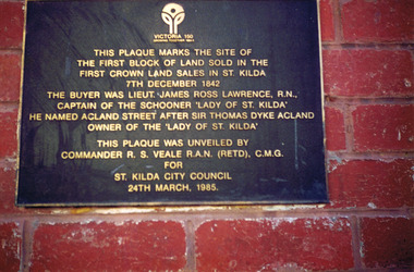
Photograph, Plaque marking the site of the first block of land sold in the first Crown Land Sales in St Kilda 7 Dec 1842, c. 1980s?
colour photograph unmounted (2 identical photographs)This plaque marks the site of the first block of land sold in the first Crown Land Sales in St Kilda 7 Dec 1842. The buyer was Lieut. James Ross Lawrence, R N, Captain of the Schooner 'Lady of St Kilda'. He named Acland st after Sir Thomas Dyke Acland, owner of "The Lady of St Kilda". This plaque was unveiled by Commander RS Veale RAN (retd) CMG for St Kilda City Council. 24 March 1985. -
 Federation University Historical Collection
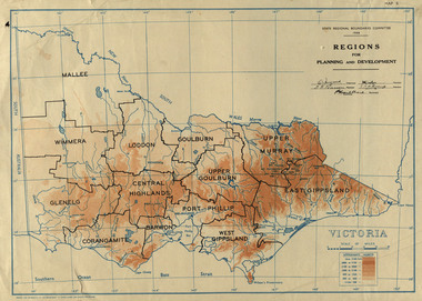
Map, Victoria: Regions for Planning and Development, 1944
This map was produced for the State Regional Boundaries Committee Two colour map of Victoria showing the regions for planning and development. The regions are Central Highlands, Mallee, Wimmera, Glenelg, Corangamite, Barwon, Loddon, Goulburn, Upper Goulburn, Upper Murray, East Gippsland, West Gippsland, Port Phillip.central highlands, mallee, wimmera, glenelg, corangamite, barwon, loddon, goulburn, upper goulburn, upper murray, east gippsland, west gippsland, port phillip, victoria, m4486 -
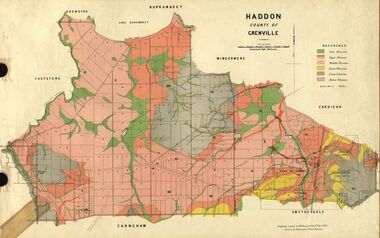 Federation University Historical Collection
Plan, Haddon, County of Grenville, 1887, 1889
Ferdinand Krause taught at the Ballarat School of MinesGeological Map of Haddon in the County of Grenville surveyed by Ferdinand Krause. haddon, grenville, krause, ferdinand krause, cgt, lake burrumbeet, windermere, chepstowe, bailies creek, snake valley lead, nentingbool preemptice right, cardigan state forest, haddon state forest -
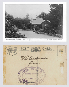 Williamstown Botanic Gardens- Hobsons Bay City Council
Postcard – Williamstown Botanic Gardens, The Crown Studios, Sydney, c1900-1920
The Curator’s lodge, designed by the Town Surveyor, HV Champion, was constructed in 1907 following the re-organisation of the north-east corner with the demolition of the old curator's cottage and erection of new gates. Lee Heap Furniture Warehouse of Williamstown used the postcards to advertise. The postcards are evidence of the interest the gardens held as a subject for postcard publishers. The text and images provide a snapshot into fashions, social interests and concerns of the time. The professionally produced images provide a pictorial history of Gardens including changing planting styles, various structures and features of the Gardens eg the aviary, cannons, the fountain, the second Curator’s Lodge and gates. The images offer an opportunity to compare garden vistas with the present day.A sepia image looking across a path bordered with rocks of a house (the Curators lodge) behind a fence. In front of the fence there is a young girl sitting on a rock with a young boy standing beside her. The house is timber with two brick chimneys, the right hand one half hidden by foliage. The house is federation style with timber battening above the front window. A timber frieze is above a verandah supported by three posts and light coloured brackets. Front: ‘Williamstown Gardens. Vic.’ ‘0457/1’ THE CROWN STUDIOS, SYDNEY’. Reverse: Centre top ‘POST CARD’ with a logo in the middle of the words. Left top corner a drawing of an artist’s board and brushes with a camera in the centre. Left side ‘MESSAGE ONLY.’ Right side ‘ADDRESS ONLY.’ Top right corner inside a dotted rectangle ‘STAMP HERE’. Bottom on card ‘BY THE CROWN STUDIOS, SYNDEY.’ Under the vertical line down the middle line ‘Neither the Address not the Message must cross this line’. In ink ‘With Compliments / from’. An oval stamp with scalloped rim ‘LEE HEAP FURNITURE MANUFACTURER’ inside inner oval ‘FURNITURE WAREHOUSE, / WILLIAMSTOWN’.postcard, gardens, post-card, williamstown-botanic-gardens, hobsons-bay-city-council, curator’s lodge, children, federation style, crown studios, lee heap furniture warehouse -
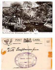 Williamstown Botanic Gardens- Hobsons Bay City Council
Postcard – Williamstown Botanic Gardens, The Crown Studios, Sydney, c1900-1920
The lake was built in 1904, during the curatorship of Mr Thake. Lee Heap Furniture Warehouse of Williamstown used the postcards to advertise. The postcards are evidence of the interest the gardens held as a subject for postcard publishers. The text and images provide a snapshot into fashions, social interests and concerns of the time. The professionally produced images provide a pictorial history of Gardens including changing planting styles, various structures and features of the Gardens eg the aviary, cannons, the fountain, the second Curator’s Lodge and gates. The images offer an opportunity to compare garden vistas with the present day.Sepia image of the ornamental lake and part of the Curator’s Lodge in the background on the left side of card. The small island with a succulent is in the centre of the image with a similar plant on the right side of it. The water is edged with rocks. Reflections of the plantings and lodge can be seen.Front: ‘The Artificial Lake, Williamstown Gardens. Vic.’ ‘0457/3’ ‘THE CROWN STUDIOS, SYDNEY’. Reverse: Centre top ‘POST CARD’ with a logo in the middle of the words. Left top corner a drawing of an artist’s board and brushes with a camera in the centre. Left side ‘MESSAGE ONLY.’ Right side ‘ADDRESS ONLY.’ Top right corner inside a dotted rectangle ‘STAMP HERE’. Bottom on card ‘BY THE CROWN STUDIOS, SYNDEY.’ Under the vertical line down the middle line ‘Neither the Address not the Message must cross this line’. In ink ‘With Compliments from’. An oval stamp with scalloped rim ‘LEE HEAP FURNITURE MANUFACTURER’ inside inner oval ‘FURNITURE WAREHOUSE, / WILLIAMSTOWN’.postcard, gardens, post-card, williamstown-botanic-gardens, hobsons-bay-city-council, ornamental lake, crown studios, lee heap furniture warehouse