Showing 93 items matching dam building
-
 Kiewa Valley Historical Society
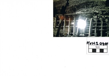
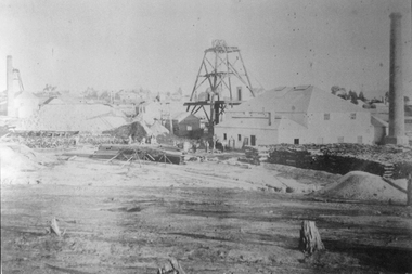
Photograph Junction Dam, Photo Junction Dam and Bogong Village in Background, circa 1950s
... , building dams and villages to accommodate workers in the 1940s ...This item clearly shows the conditions covering both working conditions and housing in the construction of the Junction Dam in the 1940s. Working conditions were extreme and health and safety legislation was at its infancy. The residential buildings were intended to last only for the period of construction, however greater demand for longevity as a tourist haven prevailedThis photo of the construction of the Junction Dam, with The Bogong village as backdrop, details the harsh conditions faced by construction workers, building dams and villages to accommodate workers in the 1940s to the 1950s. Australia at this period in time, experienced a surge of population (influx of World War II refugees), which was the catalyst for developing and undergoing an enormous hydroelectricity program for the Alpine regions, both in Victoria and New South Wales. This program was initiated to supply electricity to the major southern Australian cities of Adelaide, Melbourne and Sydney. It was thought that these developments would reduce, if not eliminate, the requirement for coal driven power stations. However time has demonstrated that these power stations have not matched the demand required by the industries and the populations of the major urban and cities.Black and white photo of original photo with a flashlight reflection in the bottom centre. The photo is on Kodak XtraLife II paper. The paper is semi gloss.This photo is of the construction of the Junction Dam Wall with the Bogong Townshiip in the background.Back of photo is printed " Kodak XtraLite II paperdam construction, bogong village, alpine development, junction dam -
 Kiewa Valley Historical Society
Photograph of Lake Guy and Bogong Village, Lake Guy and Bogong Village, Approx. 1945
In 1940 Field Headquarters for the Kiewa Scheme were established at Bogong with office, workshop facilities and accommodation for workmen, staff and some families constructed. (There had been a 'tent camp' on this site in 1939 but was destroyed by bushfires) Construction of accommodation continued until 1947. A total of 40 houses plus a hostel for single staff, post office, police station, medical centre and primary school all with water and sewerage and electricity supply. The staff hostel was known as Kiewa House and is now occupied by the Education Department. Lake Guy was named after Mr. L.T. Guy who was the Resident Engineer in charge of construction work and associated activities on the Kiewa area. He held this position from 1939 to November 1946 when he was transferred to Head Office.This photograph is an excellent historical record of Bogong Village in about 1945. It shows the layout of the town in the fairly steep terrain, the workmen's camp between the houses and the lake foreshore, the Commissioner's Lodge on the hill behind the Village, the walkway through the dam wall can be seen to the left of the spillway, the dam is on spill and note damage to the large trees is still evident from the 1939 bush fires. The Commissioner's Lodge was lost in the 2003 fires and the camp buildings were in service until 1962, when they were removed and the site converted into a public picnic area with lawns and gardens.A Black and white photograph"Lake Guy and Bogong" hand written on back of photograph.kiewa, accommodation, lake, dam, bogong -
 Kiewa Valley Historical Society
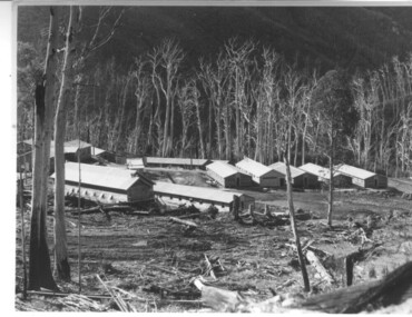
Photograph of Howmans Dam Camp, Howmans Dam Camp, circa 1948
... Black and white photograph of the buildings erected... of the buildings erected at Howmans Dam site as accommodation for workmen ...Howman's Gap camp was erected in 1948. The proposed dam to be built at this site was postponed in 1954 because of financial restraints imposed by the government at this time. It was to have supplied water for No. 2 Power Station at the Junction of the Pretty Valley and Rocky Valley branches of the East Kiewa River. This power station was not constructed until 2008 - 2010 and now gets it water from McKay Creek Power Station. The site of this camp is now occupied by the Howman's Gap Alpine Centre. Some of the original buildings still remain. An excellent photographic record of the type of buildings and size of the camp for accommodation of workmen during construction of the Kiewa Hydro Electric Scheme.Black and white photograph of the buildings erected at Howmans Dam site as accommodation for workmen.Handwritten in blue ink on the back of photograph "Howmans Dam Camp"howman's gap, camp, water, dam -
 Kiewa Valley Historical Society
Photograph of Clover Power Station, No. 3 Power Station, after May 1944
... station with the building of a coffer dam and excavation... of the power station with the building of a coffer dam and excavation ...In July, 1941 work commenced on the site of the power station with the building of a coffer dam and excavation for the power station building and machine foundations followed. Work proceeded, and the access bridge, transformer foundations and transfer track were completed in April, 1943 and the power station building in May, 1943. Installation of the machines was then proceeded with and No. 1 machine was run for the first time in June 1944. No. 2 machine was completed in April, 1944 and placed in service in May.A pictorial record for the State Electricity Commission of the first Power Station commissioned in the Kiewa Hydro Electric Scheme.Black and white photograph of the bridge and entrance to No. 3 Power Station (Clover Power Station).Handwritten on back of photograph in blue ink "No. 3 Power Station".clover, power station, machine, kiewa scheme -
 Kiewa Valley Historical Society
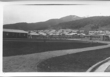
Photograph of Pretty Valley Workers Camp*, Pretty Valley Camp, circa 1949
Erection of staff quarters at Pretty Valley was completed in April, 1947 and accommodation for construction workers commenced in 1948 but suspended on 11th May for winter and resumed on 9th November. Construction of this camp was completed in 1949. A large dam was proposed at this site but was never constructed. Instead a small diversion dam was built which diverts water either to Rocky Valley Dam or to McKay Creek Power Station.An historical record of the type of accommodation provided for workmen during the construction of the Kiewa Hydro Scheme during the 1940's/50's.A black and white photograph of Pretty Valley Camp, c 1949. Dead trees are in the foreground, on both the left and right side of the photograph and a small snow gum is evident. There are camp huts and a much larger building behind these, possibly a workshop, and power poles are evident bringing electricity to the site.Handwritten in blue ink on back of photograph "Pretty Valley Camp. 5600 ft. above sea level".pretty valley, dam, water, workmen, camp -
 Kiewa Valley Historical Society
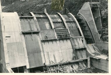
Photo - Junction Dam Construction, Circa 1940's
... workers, building dams and villages to accommodate workers ...Junction (Lake Guy) Dam is a 'slab and buttress' type wall. A timber frame is built and then filled with concrete. The first batch of concrete was placed in September, 1940. By June, 1941 the buttresses were finished to a height safe from floods and in October of that year a flood of 2,800 cusecs occurred but with only slight damage to the installations. Industrial trouble caused some delays but there was also slow progress on the part of the contractor and the work was taken over by the S.E.C., terminating the contract. The dam was completed in March, 1944. A walkway was made through the dam wall. Lake Guy was named after Mr. L.T. Guy who was the Resident engineer, in charge of construction work and associated activities on the Kiewa Area from 1939 to November 1946Photos of the construction of the Junction Dam detail the harsh conditions faced by construction workers, building dams and villages to accommodate workers in the 1940s to the 1950s. Australia at this period in time, experienced a surge of population (influx of World War II refugees), which was the catalyst for developing and undergoing an enormous hydroelectricity program for the Alpine regions, both in Victoria and New South Wales. This program was initiated to supply electricity to the major southern Australian cities of Adelaide, Melbourne and Sydney. It was thought that these developments would reduce, if not eliminate, the requirement for coal driven power stations. However time has demonstrated that these power stations have not matched the demand required by the industries and the populations of the major urban and cities.Black and white photograph of Junction Dam constructionjunction dam, bogong, secv -
 Kiewa Valley Historical Society
Photo - Junction Dam Diversion Tunnel
... conditions faced by construction workers, building dams and villages ...Junction (Lake Guy) Dam is a 'slab and buttress' type wall. A timber frame is built and then filled with concrete. The first batch of concrete was placed in September, 1940. By June, 1941 the buttresses were finished to a height safe from floods and in October of that year a flood of 2,800 cusecs occurred but with only slight damage to the installations. Industrial trouble caused some delays but there was also slow progress on the part of the contractor and the work was taken over by the S.E.C., terminating the contract. The dam was completed in March, 1944. A walkway was made through the dam wall. Lake Guy was named after Mr. L.T. Guy who was the Resident engineer, in charge of construction work and associated activities on the Kiewa Area from 1939 to November 1946.Diversion dams are installed to raise the water level of a body of water to be redirected. The redirected water is used for hydro electric power generation. A diversion tunnel is usually bored through solid rock next to the dam site to bypass the dam construction site. The dam is built while the river flows through the diversion tunnel.Photos of the construction of the Junction Dam detail the harsh conditions faced by construction workers, building dams and villages to accommodate workers in the 1940s to the 1950s. Australia at this period in time, experienced a surge of population (influx of World War II refugees), which was the catalyst for developing and undergoing an enormous hydroelectricity program for the Alpine regions, both in Victoria and New South Wales. This program was initiated to supply electricity to the major southern Australian cities of Adelaide, Melbourne and Sydney. It was thought that these developments would reduce, if not eliminate, the requirement for coal driven power stations. However time has demonstrated that these power stations have not matched the demand required by the industries and the populations of the major urban and cities.Black and white photograph of Junction Dam diversion tunnel at Bogong VillageHandwritten on back - Junction Dam Diversional Tunnelbogong, secv, junction dam, lake guy -
 Kiewa Valley Historical Society
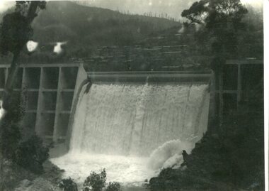
Photograph - Junction Dam spilling
... by construction workers, building dams and villages to accommodate workers ...Junction (Lake Guy) Dam is a 'slab and buttress' type wall. A timber frame is built and then filled with concrete. The first batch of concrete was placed in September, 1940. By June, 1941 the buttresses were finished to a height safe from floods and in October of that year a flood of 2,800 cusecs occurred but with only slight damage to the installations. Industrial trouble caused some delays but there was also slow progress on the part of the contractor and the work was taken over by the S.E.C., terminating the contract. The dam was completed in March, 1944. A walkway was made through the dam wall. Lake Guy was named after Mr. L.T. Guy who was the Resident engineer, in charge of construction work and associated activities on the Kiewa Area from 1939 to November 1946Photos of the construction of the Junction Dam detail the harsh conditions faced by construction workers, building dams and villages to accommodate workers in the 1940s to the 1950s. Australia at this period in time, experienced a surge of population (influx of World War II refugees), which was the catalyst for developing and undergoing an enormous hydroelectricity program for the Alpine regions, both in Victoria and New South Wales. This program was initiated to supply electricity to the major southern Australian cities of Adelaide, Melbourne and Sydney. It was thought that these developments would reduce, if not eliminate, the requirement for coal driven power stations. However time has demonstrated that these power stations have not matched the demand required by the industries and the populations of the major urban and cities.Black and white photograph of Junction Dam spilling at Bogong VillageHandwritten in pencil - Junction Dam spillingbogong, junction dam, lake guy, secv -
 Kiewa Valley Historical Society
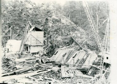
Photographs x 2 - Clover Dam, Circa 1940's
As part of the push to cut electricity costs and diversify supply, the Victorian Government (circa 1930) implemented the conversion strategy from mainly brown coal supply to hydro - electricity. The Kiewa Hydroelectric Scheme became the largest scheme of its kind in the State Of Victoria and the second largest scheme in Australia. Clover Dam and Power Station were built by the State Electricity Commission of Victoria as part of the Kiewa Hydro Electric Scheme from the late 1930's to the early 1940's. This dam was constructed to supply water to feed four turbines (62 mega watts) at the West Kiewa Power Station. This was at the forefront of sustainable "Green" energy. Costs associated with power supplies is still a major incentive of governments, however environmentally friendly alternatives such as wind and nuclear have also made inroads. The Kiewa valley and its surrounding alpine catchment were looked at(Victorian State Government), from the beginning of the twentieth century as a source of alternate power for an ever-increasing demand for electricity by growing population and heavy industrial areas within Melbourne City and State regions. Construction of dams, such as Clover Dam provided the large quantity holding areas of water required to turn the turbines at the various power stations to provide the electricity needed. The impact of these controls by moderating water run-off from the alpine regions is beneficial in reducing flooding from thawing of snow on the alps. This by-product allows agriculture and grazing to be less vulnerable to seasonal flooding thereby resulting in a more stable annual production level. Photographs also document early engineering and building techniques used in the construction of dams and power stations during the 1940’s and 1950’s. Note the lack of safety equipment and suitable work attire worn by construction workers on the sites 1. Black and white photograph of Clover Dam under construction. Has a .5cm white border around photo 2. Black and white photograph of Clover Dam under construction showing workmen at work. Has a .5cm white border around photo Written in pencil on back of both photographs - Clover Damclover dam, secv -
 Kiewa Valley Historical Society
Photographs x 2 1. Lake Guy & Bogong Village 2. Bulldozer moving rocks
1. In 1940 Field Headquarters for the Kiewa Scheme were established at Bogong with office, workshop facilities and accommodation for workmen, staff and some families constructed. (There had been a 'tent camp' on this site in 1939 but was destroyed by bushfires) Construction of accommodation continued until 1947. A total of 40 houses plus a hostel for single staff, post office, police station, medical centre and primary school all with water and sewerage and electricity supply. The staff hostel was known as Kiewa House and is now occupied by the Education Department. Lake Guy was named after Mr. L.T. Guy who was the Resident Engineer in charge of construction work and associated activities on the Kiewa area. He held this position from 1939 to November 1946 when he was transferred to Head Office. 2. Example of the type of heavy machinery used in clearing and building of Lake Guy, Bogong Village and Clover Dam 1. The Bogong Township was developed firstly as an accommodation centre (base camp) for construction workers employed under the Kiewa Hydroelectric Scheme. At the completion of the scheme, in the 1960's, the village was opened to public/tourism use. Strict environmental control has not allowed for any extensive redevelopment in tourist accommodation and basically restricted it to the accommodation initially built for the construction workers. Lake Guy is one of the many water storage reservoirs used to supply the power stations their main power to run the huge turbines generating the final product, electricity 2. Pictorial record of the types of machinery used in the development of Bogong Village and the Hydro-electricity scheme including the Clover Dam. Note the lack of safety equipment worn by construction workers of the period. 2 black and white photographs taken at Bogong 1. Lake Guy with Bogong Village in the background 2. Workman in bulldozer clearing rocks, possibly for construction at Bogong1. Handwritten in blue ink on back of photo 'Lake Guy showing Bogong Village' 2. No markingslake guy, bogong village, secv -
 Kiewa Valley Historical Society
Photographs and copies of photographs of the pack horses and early horsemen who transported supplies to outposts in the Bogong High Plains, via cattle tracks before access roads were made
In the mid to late 1930’s survey outposts were established to plot the early stages of the Kiewa Hydro Electric System for the SECV in the Bogong High Plains. Before any roads were built, the old cattleman’s tracks were used with packhorses to deliver supplies, wages and mail and collect timesheets and correspondence from the workmen and dam builders living in canvas tents and at the outlying survey posts. The trip up the mountain was long and hard and dangerous for both horse and man Most of the men of the survey teams were not bush-men and were often ill equipped for the harsh weather and living conditions of bush camping, often arriving in their city clothes ready for work. The tent city at Bogong was destroyed by bush fires in 1939 after which an access road was built from Mt Beauty to transport building materials for more permanent dwellings for workmen. Pack horses continued to be used for transporting goods etc. to workers further up the mountain.Without the work of horsemen and their pack horses providing supplies and communications for outlying outposts, surveying and early planning for the Kiewa Valley Hydro Electric scheme could not have gone ahead and the dams and power stations which support the system could not have been constructed. The Hydro-electric scheme, and the workers who planned and built it play a major part in the early history of the Kiewa Valley and many original families still remain living, or have ties with the local area.: Set of 21 black and white photographs and copies of photographs depicting the pack horses and the men who handled them, transporting supplies and correspondence to the outlying camps and survey posts in the Bogong High Plains, via the rough cattlemen’s tracks. Photographs also show the early tent camps of the workers. Some photos mounted on A4 white paper. Some photos enlarged to A3 poster size for display1. Handwritten on back – Max Lawrence 2. -8 No inscriptions 9. Handwritten on back- Packing in supplies for early workers of the Kiewa Hydro scheme. There were no roads in the early days of the scheme 10. Printed on bottom of photo- Roper’s cattle on road below Howman’s Gap 11. Handwritten on back – Roper’s et al about to leave for the high plains 12. Printed under photo- Syd Ryder at the Pretty Valley Cut-Out (JBR) 13-16. No markings 17. Printed under photo- Gwen Talbot visits the Camp area. 1937 18. Handwritten on back- 14/1 Barbara Talbot 19. No markings 20-21. No markings 22. Printed under photo- STATE ELECTRICITY COMMISSION OF VICTORIA. Date: 15-3-45 Time: 8.0pm No: K 1838 Kiewa Hydro-Electric Works, Investigations 1944-1945 – Survey Camp at Young’s Hut pack horses; bogong high plains; survey posts; supplies delivery -
 Kiewa Valley Historical Society
Report - Alpine Study Area Volume 2 Maps, Land Conservation Council, 1970s
... for future development such as mineral exploration, building of a dam ...The Victorian Environmental Assessment Council and the former Environment Conservation Council (ECC) and Land Conservation Council (LCC) have completed 36 land use investigations over more than 35 years, including 27 regional reviews. They provide a framework for use of Public Land in Victoria. The Land Conservation Council was established by the Land Conservation Act 1970.These maps provide an assessment of the Alpine area at the time the maps were created. Some of the topics eg. Rainfall and water resources may change over the years thus providing a comparative analysis. Others may provide information for future development such as mineral exploration, building of a dam / tunnel etc.Blue box shaped folder containing 9 of 10 Maps of the Alpine Study Area produced by the Land Conservation Council. Maps include 1. Public land and descriptive blocks. 2. Physiography. 3. Topography. 4. Geology (missing). 5. Rainfall and water resources. 6. Vegetation 7. Land systems. 8. Recreation. 9. Primary production. 10. Minerals Ex library item. Stamped in red "Discarded From Stock / Swan Hill Regional Libraryalpine area, maps of alpine area, land conservation council -
 Kiewa Valley Historical Society
7 small black and white photographs of Pretty Valley, c1948
In 1947 it was proposed to construct a dam on the Pretty Valley branch of the East Kiewa River. This was part of the initial planning in 1937. The Pretty Valley Reservoir was to be part of a pumped-storage scheme with a pumping station located immediately below the main structure. Preparatory work was commenced in 1946 with erection of staff accommodation. Between 1947 and 1950 the main camp was erected, access roads, constructed and banks and benches at the dam site undertaken. Following the financial crisis in 1951, a review of the scheme was carried out and work ceased in June 1951. Construction of the dam was deleted from the programme of works and all buildings removed.A pictorial history of part of the initial planning in 1937 for a dam to be constructed at Pretty Valley as part of the Kiewa Hydro Electric Scheme.7 small black and white photographs of Pretty ValleyAll photos have a circular stamp on the back with 'Print by Willson White Albury' enclosed. Photo 1 - on the back, handwritten in ink 'New 22Kv pump line - Pretty Valley Nov. 1948'. In pencil '18'. Photo 2 - On the back, handwritten in ink 'Pretty Valley - Staff mess on right Nov. 1948'. In pencil '18'. Photo 3 - On the back, handwritten in ink 'Pretty Valley Basin - looking S.E. Nov. 1948'. In pencil '5'. Photo 4 - On the back, handwritten in ink 'New pump 22Kv line, Pretty Valley - looking towards Mt. Mackie. Nov. 1948'. In pencil '5'. Photo 5 - On the back, handwritten in ink 'Pretty Valley. Mt. Cope just out of picture extreme right. Nov. 1948'. In pencil '78'. Photo 6 - on the back, handwritten in ink 'View from Pretty Valley Ruined Castle in Background Nov. 1948'. In pencil '78'. Photo 7 - on the back, handwritten in ink 'Pretty Valley Pump line (Nov. 1948)'. In pencil'78'.construct, dam, pretty valley -
 Kiewa Valley Historical Society
5 small black and white photos of Clover Dam and Power Station, c1948
The construction of Clover Power Station was commenced in October 1942 and the power station building was completed in May, 1943. The first machine was placed in service August, 1944 and the second machine in May, 1945. The water discharges directly into Clover Dam and re-used in West Kiewa Station. Clover Dam - stripping of foundation area commenced in January 1948 but the final concrete pour was not until 14th August, 1954.Pictorial history of the early construction undertaken in the building of the Kiewa Hydro Electric Scheme. Clover power station (No. 3 Development) was the first power station to be built .5 small black and white photographsPhoto No. 1 - handwritten in ink on back ' No. 3 Power Station Clover Flat Nov. 1948 Photo No. 2 - handwritten in ink on back 'No. 3 Power Station Clover Flat Nov. 1948 Photo No. 3- handwritten in ink 'Clover Flat looking towards work area of Clover Dam. Taken near #3 PS. Nov. 1948 Photo No 4 - Handwritten in ink 'Preparation for wall of Clover Dam Dec. 1948 Photo No.5 - handwritten in ink 'Preparation for wall o f Clover Dam Dec. 1948. Photo Nos. 1,2 3, on the back have circular stamp with 'Print by Willson White Albury'. In pencil is the number '78'. Photo Nos. 4, 5, have written on the back in pencil, number '14'. construction, clover power station, clover dam, -
 Kiewa Valley Historical Society
Photograph - Folder of Photographs – Photocopied set of 10 black and white photographs (pages 19 - 28) from the display folder put together by KVHS to document life on the Kiewa Valley Hydro-electric Scheme
... Waters 9-No1 Head Race Tunnel Portal Building 10-Clover Dam ... Building 10-Clover Dam 1-STATE ELECTRICITY COMMISSION OF VICTORIA ...Although the Kiewa Hydro-Electric Scheme was first proposed in 1911, construction did not commence until 1938. As part of the push to cut electricity costs and diversify supply, the Victorian Government (circa 1930) initiated the conversion from primarily brown coal supply to hydro – electricity. Field investigations during the 1940’s resulted in a new proposal for a scheme that had more than double the capacity of the 1938 scheme. The Kiewa Hydroelectric Scheme became the largest scheme of its kind in the State Of Victoria and the second largest scheme in Australia. The number of personnel involved in the planning and construction of the scheme increased dramatically. During the late 1940’s, most activity centred around the construction of the West Kiewa Power Station, Rocky Valley Reservoir, McKay Creek Power Station and the Bogong Creek Aqueduct.A common thread across all the larger hydro scheme constructions was the need for workers, both qualified and unqualified who came from around the world seeking a new life for themselves and their families. New accommodation and facilities were required for the army of workers engaged in construction in often remote and wild areas. The SEC had a high demand for timber, and set up the first of a number of sawmills at Bogong Creek in 1939 and set up the first hardwood logging in the headwaters of the Kiewa River. These new ‘towns’ such as Mt Beauty and Bogong, survived, serving the needs of operational personnel and their families, and expanding with growth of new industries. Mount Beauty, and to a lesser extent Bogong, are among these places. Large A3 size spiral bound display folder containing 21 pages of photocopied black and white photographs of various aspects of the early days of the Kiewa Valley Hydro-electric scheme including equipment, various work sites and photographs of workers and their families. 1-Allis Chalmers Tractor School 2- Gardens outside Administrative Office – Mt Beauty 3- Mt Beauty house – 1950 4-Bridge over Pretty Valley River, Bogong 5-Rocky Valley Spillway Tunnel break through 6-Ni 1 Headrace Tunnel drilling face 7-No 4 Power Station Drilling 8-Clover Dam Flood Waters 9-No1 Head Race Tunnel Portal Building 10-Clover Dam 1-STATE ELECTRICITY COMMISSION OF VICTORIA Date: 5.9.49 Time: 10amm No K5174 Kiewa Hydro Electric Works Allis Chalmers Tractor School Page number 19 2-STATE ELECTRICITY COMMISSION OF VICTORIA Date: 22.2.50 Time: 3.30pm No K5601 Kiewa Hydro Electric Works Gardens outside Administrative Office – Mt Beauty Page number 20 3-Mt Beauty house – 1950 Page number 21 4-STATE ELECTRICITY COMMISSION OF VICTORIA Date: 23.10.50 Time: 11.15am No K6331 Kiewa Hydro Electric Works Bogong-Bridge over Pretty Valley River Page number 22 5-STATE ELECTRICITY COMMISSION OF VICTORIA Date: 23.6.50 Time: 2.30pm No K5844 Kiewa Hydro Electric Works ROCKY VALLEY SPILLWAY TUNNEL BREAK THROUGH Page number 23 6-20/3/52 – No. 1 Headrace Tunnel Drilling face (E.E.E. contract) Page number 24 7-6/6/52 – No 4 Power Station – Drilling Page number 25 8-STATE ELECTRICITY COMMISSION OF VICTORIA Date: 6/6/52 Time: No K7113 Kiewa Hydro Electric Works Clover Dam Flood Waters Page number 26 9-STATE ELECTRICITY COMMISSION OF VICTORIA Date: Oct 1952 Time: No K7239 Kiewa Hydro Electric Works No. 1 HEAD RACE TUNNEL PORTAL BUILDING. Handwritten underneath – This information from Ron White-the later Principal Hydro Engineer of the SEC. Oct 1952 Location incorrect? All work on No 1 had ceased after financial crash of 1951. This photo would refer to No 4 Headrace Tunnel? Page number 27 10-STATE ELECTRICITY COMMISSION OF VICTORIA Date: Jan 1953 Time: No K7307 Kiewa Hydro Electric Works CLOVER DAM Page number 28 secv; kiewa hydro electric scheme; bogong; mt beauty; construction area -
 Kiewa Valley Historical Society
Photograph – Set of 3 black and white photographs of Bogong Village circa late 1930's - 1940's during early construction of Lake Guy ( in the foreground), Late 1930's - 1940's
In 1940 Field Headquarters for the Kiewa Scheme were established at Bogong with office, workshop facilities and accommodation for workmen, staff and some families constructed. (There had been a 'tent camp' on this site in 1939 but was destroyed by bush fires) Construction of accommodation continued until 1947. A total of 40 houses plus a hostel for single staff, post office, police station, medical centre and primary school all with water and sewerage and electricity supply. The staff hostel was known as Kiewa House and is now occupied by the Education Department. Lake Guy was named after Mr. L.T. Guy who was the Resident Engineer in charge of construction work and associated activities on the Kiewa area. He held this position from 1939 to November 1946 when he was transferred to Head Office. The Bogong Township was developed firstly as an accommodation centre (base camp) for construction workers employed under the Kiewa Hydroelectric Scheme. Due to the influx of European workers into the Township the beautification of the immediate surrounds (gardens etc.) had a distinct European flavour. This environment has been very beneficial for tourism in later years. At the completion of the scheme, in the 1960's, the village was opened to public/tourism use. Strict environmental control has not allowed for any extensive redevelopment in tourist accommodation and basically restricted it to the accommodation initially built for the construction workers. Activities such a bike riding, snow skiing, restricted horse riding and bush walking on the Alpine plains and mountains are now a viable part of the Kiewa Valley Tourist Industry. The lake is one of the many water storage reservoirs used to supply the power stations their main power to run the huge turbines generating the final product, electricity3 black and white photographs of the Bogong camp area showing the clearing of trees for the construction of the Junction Dam and Lake Guy. Some administration buildings have been constructed, but part of the tent camp can be seen to the right of the photograph in front of the buildings. bogong village; junction dam; lake guy; kiewa hydro electric scheme; secv -
 Kiewa Valley Historical Society
Photographs - Townships of Mt Beauty and Bogong and the Kiewa Valley, c 1940, 1950, 1960
The township of Mt. Beauty was built to provide family accommodation for personnel working on the construction of the Kiewa Scheme. construction commenced in 1946. Photo 1 is looking towards the corner of Lakeside Ave. and Kiewa Crescent. The Post Office is on the corner and the original building housing the Co op store was in Kiewa Crescent. Photo 2 is taken at a later date as the garden in front of the Post Office is well established. The Community Centre is centre left of the photo and the back buildings are the staff accommodation called "The Chalet". Photo 3. Farming country taken from Wallacedale. The Wallaces were one of he early farming families in the Kiewa Valley. Photo 4. This photo is of Junction Camp at Bogong Village and was commenced late in 1939 and by 1940 accommodated 96 men who were engaged in work on Junction Dam. Sleeping accommodation was provided in hutments, each of four rooms, each room being approx. 12 feet by 10 feet and provided for the accommodation of 2 men. This camp remained in use until November 1962.These photos have both historical and social significance. They show the type of accommodation available for workers during the construction of the SEC Kiewa Hydro Scheme as well as early streetscape views of Mt. Beauty. The Junction Camp photo also shows the state of the forest following the 1939 fires in the area.4 Black and white photographs of various sizes.Photo 1. On back, hand written in pencil: top left hand corner: "Sept 1950". Centre of photo: "Return to Gibson Envelope". Right hand side: "Cooper". Bottom left corner: "Mt. Beauty Camp SEC Kiewa Scheme". Photo 2. No inscriptions or markings. Photo 3. Back of photo handwritten in pencil: "In W>T> June 14. 1961 page31. Some of the farming country in the Kiewa Valley. This taken from the home of Mr. Geoff Wallace Wallacedale, Kergunyah where some of his 600 cattle were rounded up." Bottom right corner "Return to Gibson Envelope". There is a copyright stamp belonging to "the Herald & Weekly Times Ltd. also on the back. Photo 4. Typed on a sticker on the back of the photo "Stable attendants Cottage and Camp Sept. 1940".camp, sec kiewa scheme, kiewa, cattle, mt. beauty -
 Kiewa Valley Historical Society
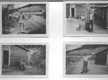
Photograph - 8 Black and white photographs - SECV, Unknown
All eight photographs have been taken at a workmen's camp erected by the State Electricity Commission to house workmen during the construction of the Kiewa Hydro Electric Scheme. These were established in close proximity to various work centres - Junction Camp at Bogong Village, three camps at Mt. Beauty, West Kiewa, Clover Dam and Clover Flat, Howman's sawmill and Howman's Gap, Rocky Valley, Langford's Gap, Pretty Valley, Mountain Creek and Big Hill. These photos have not been identified as to which camp they are taken but typical of the type of accommodation for wages personnel. They followed a general design and layout. There was a mess and recreation hall as well as a building for general trading and postal facilities (this conducted by proprietors of trading stores in Mt. Beauty and Bogong). Originally the rooms accommodated 2 men but later there was a demand for single rooms - the floor size then being 10 feet x 8 feet and furnished with a bed, small table and chair and cupboard with hanging space. The first camps were erected in 1940 and the last was removed in 1962.These photographs are of historical significance as they show the type of accommodation provided for wages personnel working on the Hydro Electric Scheme between 1940 and 1960.Eight small black and white photographs of unknown person and workmen's camp.All photos have been stamped on the back - Two "965U" in red, four "S80 " in green (indistinct) and two "141" in red.workmen's camps, kiewa hydro electric scheme, accommodation, secv, camps on kiewa hydro electric scheme, west kiewa -
 Kiewa Valley Historical Society
Alex McCullough Collection - Notes and Photos on History of Mt Beauty
Alex McCullough was a resident of Mt Beauty for many years and wrote a book on the History of Mt Beauty. Mt Beauty was constructed by the State Electricity Commission of Victoria to house employees working on the Kiewa Hydro Electric Scheme. Alex was involved with many organisations in Mt Beauty and interested in history. He took many photos of events and new developments in town. He also collected individuals memoirs on life in the town.Mt Beauty's history is unique as it was built as a construction town in the late 1940s. The information in Alex's Collection records the town's development perhaps in more detail than in his book "The History of Mt Beauty". His folder includes his education, his work with the SECV (foreman working on Clover Dam), his war service, his community work (Mt Beauty & District Progress Association & Mt Beauty Neighbourhood Centre) and awards, work as Shire Councillor and Mayor, sporting (tennis & golf) interests. Alexander John McCullough 1916 - 2011's obituary is online ref. legacy.comA) Booklet - The Life of Alex McCullough B) Booklet - The Story of Kiewa by Alex McCullough C) Coloured photos 15cm x 10 cm of the renovation of the Mt Beauty Neighbourhood Centre mid 2001. Four photos are labelled by Alex McCullough on the back. Also, photos of various sizes both colored and black and white depicting sites and people in Mt Beauty. Not labelled.Also, six packets of negatives of older photos incl. Community Hall, Fire Brigade, School, School ski group, Back to Kiewa, Alpine Study, D) Alex McCulloughs 1951 Diary - Clover Dam E) Random Items from History Profile Kiewa by Alex McCullough F) Papers - 'Administration of Mt Beauty Township' - 2nd July 1957. SECV buildings in Mt Beauty shared with community groups notes re - arrangement between groups. G) Barrie Wilcox's Memories living in Marum's paddock from c1940s onwards. Written in June 1999 H) Mt Beauty website June 1998 - a lot of history I) Papers - Mt Beauty High School band developement J) The 1950s Development of the Birth of Community support organisations K) Community Centre Mt Beauty opening 3rd August 1951 L) Mt Beauty Fire Brigade History M) Folder Personal papers re Alex McCullough alex mccullough, mt beauty history, community work -
 Kiewa Valley Historical Society
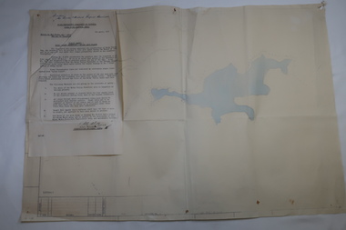
Plan Ref. K. 6612 with Letter attached re Public Safety in Kiewa Works Area
... included the building of Rocky Valley Dam on the Bogong High Plains... the building of Rocky Valley Dam on the Bogong High Plains near Falls ...The SECV constructed the Kiewa Hydro Electric Scheme which included the building of Rocky Valley Dam on the Bogong High Plains near Falls Creek. H.H.C. Williams, construction engineer, Kiewa wrote to the Ski Clubs at Falls Creek outlining the dangers arising with the filling of Rocky Valley Dam. He lists 5 warnings in the interest of safety.The plan and letter provide the dates for the completion of Rocky Valley dam and its effect on the people living and working in the area including miners and ski clubs. It describes some of the features of Kiewa Works Area at the time.Plan No. K 6612 of Fall Creek showing Rocky Valley Dam's shape when it is full. Letter dated 6th April 1959 from H.H.C. Williams to Ski Clubs at Falls Creek re public safety as Rocky Valley fills. Refers to roads, transmission lines, pole lines etc in the Kiewa Works Area.Written in ink at top of letter - "Secretary / Mt Beauty and District Progress Association"rocky valley dam, falls creek ski clubs, h.h.c. williams, khes 1959, safety -
 Learmonth and District Historical Society Inc.
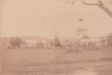
Photo, "Willow Vale" Waubra, Victoria, Late 19th Century or Early 20th Century
It show the farm "Willow Vale" Waubra that was once owned by the Christopher and Selina (nee Smith) Harrison family who once lived on this farm and whoes descendants continue to live in the same area today.A very pale sepia photo of the "Willow Vale" farm at Waubra, Victoria that was owned by Christopher and Selina (nee Smith) Harrison. It shows a horse and buggy, along with the main house/houses and out buildings with what look like it could be a slightly dry dam at the bottom of the photo.Nil -
 The Beechworth Burke Museum
Photograph, c.1927-1930
... and 1930, and was made a necessity by the building of the Hume Dam... a necessity by the building of the Hume Dam. The Hume Dam, formerly ...This image shows the Punt (a kind of small boat) that took residents of Bethanga across the Murray River before the Bethanga Bridge was built. Bethanga Bridge was built between 1927 and 1930, and was made a necessity by the building of the Hume Dam. The Hume Dam, formerly known as the Hume Weir, was in construction between 1919 and 1936, which swelled the Murray River into the floodplain to the East of the dam permanently, creating Lake Hume, and isolating the residents of Bethanga and nearby towns, for whom the trip all the way around the new lake to another river crossing was a massive undertaking. The person who wrote on the back of this card instead chose to cross the river on a boat until the Bethanga Bridge became available. Interestingly, partially submerged trees can be seen in the lake in the background of this photograph, illustrating that the dam had already begun to fill the floodplain even before the bridge was built. This photograph shows the methods the residents of Bethanga used while the Bethanga Bridge was being built. This record is associated with the Heritage Listed sites of the Hume Dam and the Bethanga Bridge, and shows the environment during the process of construction and the creation of Lake HumeSepia rectangular photograph printed on matte photographic paperReverse: 1997.3189 / 84 -19 -1 / This is the snap of the Punt. / Our only means of getting out / of Bethanga for the present / Until the bridge is completed / it is 2 miles above the junction / of the Mitta + Murray. It is / 1/2 a mile wide + runs across / the Murray into NSW / Kodak Print / bethanga, bethanga bridge, hume, hume dam, artificial lake, lake hume, hume weir, flood, floodplain, boat, punt, weir, pier, dock, transport, transportation -
 Surrey Hills Historical Society Collection
Photograph, Muriel Pornitz (deceased), Quarry on site of Grovedale Road - James Street Park
The photo is of a painting of the dam formed on land between Grovedale Road and James Street, Surrey Hills. It was painted in 1927 by Miss Muriel Pornitz, an art teacher, who lived in Grovedale Road. The land had been part of Mr James Maling Snr’s property and in the 1880s clay was removed to build houses, including his own located on the corner of Weybridge and James Streets. Maling grazed cattle on this area and used it as a dam. The land was subsequently made into parkland, the quarry / dam having been filled in after several drownings had occurred in the 1920s/1930s. See also SHP94, another copy of the same. Muriel Hedwig Lucy Pornitz lived at 22 Grovedale Road, Surrey Hills. She was born c1894 in Balwyn; died in Kew on 1 December 1982. She was the daughter of Konrad Pornitz (1864-1903) and his wife Charlotte Richardson Gooderidge (1863-1942), known as Tottie, who married in 1890. Konrad Pornitz is listed in the 1892 directory as living in Edgevale Road, Kew and the business Pornitz and Ross at 291 & 293 Little Collins Street, importers and commission merchants. The 1896 directory gives the Kew address as 176 Edgevale Road, Kew, however the business Pornitz and Ross was dissolved on 1st day of October 1892, by mutual agreement. Legal notice advised that: Mr Pornitz will hereafter carry on the business on his own behalf at the same address, under the style "Pornitz and Ross". Muriel is buried in Box Hill Cemetery (B-086-0042) along with Ulrich Horst Holm Pornitz known as Horst or Bon (d 1957) and Edith Olga Pornitz (d 1951), her brother and sister. A further sibling (Konrad b 1891) died in infancy. He is buried with his mother in Boroondara (Kew) Cemetery - C/E A 0366. Konrad died at his home 'Yarran' in Lane Cove Road, North Sydney on 31 October 1903; reported in the Sydney Morning Herald. Buried Gore Hill Cemetery, St Leonards, North Sydney. The headstone reveals he was born in Chemnitz, Saxony in 1863. Muriel was also known as Muriel Pornett. She studied at the South Australian School of Arts & Crafts in 1911 under James Ashton and Fred Britton, and at the Australian School of Etching in Sydney. She was also an illustrator and cartoonist. The photo, and the painting from which it is derived, documents the landscape prior to close settlement and is material to early building and farming in the Surrey Hills area.A black and white photograph of a painting of a landscape of parkland. Two trees are on top of a rise and are reflected at the bottom in water. The signature of the artist is in the bottom right corner: "AUST MP 192" (and the rest is cut off).(miss) muriel pornitz, grovedale road, james street, surrey hills, artists, parks and reserves, (mr) john butler maling, snr, quarry, dam, (miss) muriel hedwig lucy pornitz, box hill cemetery, muriel pornett -
 Tatura Irrigation & Wartime Camps Museum
Photograph, Eildon, 1957
Taken by photographer for State Rivers and Water Supply Commission.Large sepia photograph. Featuring huge earthen dam wall middle-right of photo - water in reservoir held back by wall left of middle - hills beyond forming horizon - utility buildings foregroundvictoria state rivers and water supply commission, eildon, eildon reservoir -
Creswick Campus Historical Collection - University of Melbourne
Book, 1955 -1963
Fire Protection plan DamsDocument -
 Stawell Historical Society Inc
Photograph, North Cross Reef Mine & Mining Scene 1870 -- Coloured
Mining Scene - North Cross Reef Co.B/W North Cross Reef with buildings, poppet heads, Tailings and wood stack with people. Two colour prints of North cross Reef. One at a different angle to B/W. Second taken further back with wood stacks, tailing dam fenced in beyond poppet heads buildings chimmney's smoking. stawell -
 Hepburn Shire Council Art and Heritage Collection
Public Art Work, Boy with a thorn - 'Lo Spinario', c. 1900
Boy with a Thorn Though the classical bronze that the figure was modeled has become known as Lo Spinario, both Stuart Rattle and Kevin O’Neill referred to it as The Boy with a Thorn. Information from the late Stuart Rattle and John Graham, the late Kevin O’Neill’s partner. The statue was bought by Kevin O’Neill from a South Yarra antique dealer in the 1980s. She had bought it in Europe. Stuart believed that it was cast in Berlin by Moritz Geiss who had pioneered the popular process of zinc casting of classical statues. Schinkel, the architect of early 19th Century Prussian public buildings used the process extensively. I assume that the decorations that can be seen in Berlin currently are copies of those copies, given the comprehensive destruction of the city in 1945. Unless there is a date stamped on the statue, and there might well be, there is no firm indication of its age, although Stuart and Kevin believed it was “turn of the century”. It was given to Stuart by John Graham after the death of Kevin O’Neill. Prior to its installation at Musk Farm, it was “by the dam” at Marnarnie, O’Neill’s property at Mt Macedon. It became a much photographed focal point in the sunken garden at Musk Farm. The statue is a gift from the Rattle family to The Friends of Wombat Hill Botanic Gardens who intend to give it, in turn, to Hepburn Shire to be placed in the Botanic Gardens. Both the family and the Friends see it as a memorial to Stuart’s tireless work to raise funds for the Gardens and to raise the profile of the Gardens so that their considerable significance could be more broadly acknowledged. The CMP notes that statuary has been a feature of most botanic gardens (and a notable feature of the Ballarat Botanical Gardens) and James Lowe, the head of Parks for the Shire has also commented that it is an area that could well be developed in the Gardens. This comes from his attendance at meetings of the BGANZ, the “peak professional body” for the development and maintenance of registered botanic gardens in Aus and NZ. Given the lack of funds that the Shire has been able to allocate to the Gardens, a donation of this calibre is a welcome addition to the cultural asset that the Gardens represent. A very large number of residents of the Shire are members of the Friends, have visited Musk Farm and are appreciative of the Gardens. There is a current feeling that the Gardens are undergoing a dynamic revival as a result of the success of the Café and also because of the extraordinary improvement and enhancement of the amenity that has been undertaken over the past two years by the Friends. The installation of the Boy with the Thorn is another move forward for the Gardens. The statue is cast zinc. It is sometimes referred to a white bronze. As can be seen in the photographs, it is in very good condition with no damage or apparent degeneration of the metal. The Smithsonian Institution has a lengthy document relating to the deterioration and repair of similar casts in the US where urban pollution has taken its toll but for the most part it deals with inappropriate repair rather than maintenance protocols. One of the properties of zinc that is appreciated in Australia is its ability to withstand the elements and given that the artwork has been either on Mt Macedon or at Musk for the last 30 years or more, its relocation to Wombat Hill seems to be an appropriate one. The Friends are prepared to organise and pay for the relocation of the statue. The issue of security from the point of view of theft, malicious damage and environmental impact will need to be addressed. The Ballarat Botanical Gardens have recently reinstalled statuary which has been damaged and which had been removed from the Gardens on account of this. They have used Rockworks Ballarat and Wilson’s Memorials to make plinths, secure artworks with steel pins and to provide especially robust fixings to ensure the safety of the various sculptures. The CMP (2007) makes a number of recommendations regarding security in the Gardens ranging from the installation of lighting to the locking of the gates overnight and the repair/reinstatement of appropriate fencing – not done as yet to my knowledge. Paul Bangay has also agreed to act as a consultant in the process of installing the Boy. John Graham estimates its value at $20,000 The preferred location for the work would be at the entrance to the Fernery from the lawn. The paths form an intersection at that point that could be modified to fit the statue. But this is currently a suggested location only. The statue is a gift from the Rattle family to The Friends of Wombat Hill Botanic Gardens who have gifted it to the Hepburn Shire to be placed in the Botanic Gardens. Both the family and the Friends of the Wombat Hill Botanical Gardens Daylesford see it as a memorial to Stuart’s tireless work to raise funds for the Gardens and to raise the profile of the Gardens so that their considerable significance could be more broadly acknowledged. Lo Spinario (Boy with a thorn) c. 1900 copy after the Greco-Roman Hellenistic antique bronze in Rome. c. 1900 copy after the Greco-Roman Hellenistic antique bronze in Rome (Palazzo dei Conservatori, Musei Capitolini, Rome) Manufacturer M. Geiss, Berlin Nonedaylesford, wombat hill botanical gardens, stuart rattle, kevin o'neill, john graham, boy with a thorn, lo spinario, classical sculpture, zinc, classical nude, hepburn shire, public art, sculpture, art -
 Hume City Civic Collection
Photograph, Early 1980's
The mud brick cottage and outbuilding was possibly built by James Waylett in the 1850's and it is only one of three remaining mud brick buildings in the Oaklands-Greenvale which were constructed in the late 19th Century.A coloured photograph of farm scene. A dam is in the foreground and the remains of a mud brick cottage and timber and corrugated building in the middle distance. Further farm buildings can be seen in the distance.mud brick buildings, waylett, james, farm buildings, sherwood, somerton road, oaklands hunt club, george evans collection -
 Mt Dandenong & District Historical Society Inc.
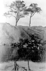
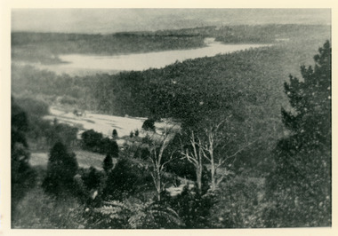
Photograph, Harmony Vale 1933
John Lundy-Clarke grew up in the Kalorama/Mt Dandenong area and later in life (1972-74) began to write a comprehensive history of the area working from an original settlement map in an effort to cover all areas. Harmony Vale was the name of the homestead built by early pioneer Jabez Richardson. The whole of the valley took on this name. The building lasted until 1933. The Silvan Dam was completed in 1932 and was full when this photograph was taken.Black and white photograph looking down over a forested area with a dam in the background. Copied from a Rose Series postcard c1933. Handwritten inscription on reverse by John Lundy-ClarkeRose Series photo of 1933 showing “Harmony Vale” still standing. Copied 1973 JLCharmony vale, silvan dam, jabez richardson -
Federation University Historical Collection
Document - Reports, Martin Westbrooke, Nanya Station
Nanya Station, owned and managed by the University of Ballarat (now Federation University Australia), was purchased with assistance from the Department of Environment and Heritage Government Caring for our Country program. Nanya Station is located in the Scotia country, west of the Darling Ana-Branch in far western New South Wales and consists of the Nanya Western Lands Pastoral Lease 3281 – Perpetual Leasehold Lot 1244 in Deposited Plan 762778, Parish of Winnebaga, County of Tara and part of Lot 1242 County of Windeyer. Nanya is within the tribal area of the Danggali Aboriginal people, a sub-group of the Barkindji. Many Aboriginal sites have been recorded adjacent to major rivers in the region providing evidence that these areas supported a large population. The Scotia region has one of the shortest stock grazing histories of western NSW. Along with five other Scotia properties, Nanya was created as a pastoral lease in 1927. The first European settlement on the land followed exploration of the area by Sturt and Eyre. In 1854, the Lake Victoria lease which encompassed this area comprised 465,000ha.included Scotia blocks 1, 2, 3 and 4, Amoskeag and Winnebaga which formed the area known as the Scotia. It was described as a region of thick mallee scrub, interspersed with bluebush flats and Belah woodland. In the 1920s artesian water was found and the dry Scotia country was surveyed and divided into six Homestead leases allocated by ballot (Withers 1989). All properties were approximately 30,000ha, with a recommended stocking level of 3,000 sheep. Winnebaga (renamed Nanya) was taken up by Gordon Cumming. He initially dug a dam near the southeast corner of the property. A larger ground tank and rudimentary dwelling at the site of the present complex was later established. An adjacent area was cleared and cropped to provide feed for the horses used in digging the earth tanks. The ruins of the original building are located between the shearing shed and Homestead Tank. A cottage was built in the 1930s and a more substantial Red Gum framed homestead in the early 1950s. The lease was held by Mr Gordon Cumming until 1984 when it was purchased by Mr Norm Scadding as an extension to the adjacent lease, Belvedere. It was sold in 1995 to Mr Rob Taylor of Waikerie then in 1999 to BeMax Pty. Ltd., a sand mining company. These last three owners all permitted use of the property by the University for teaching and research. The Centre for Environmental Management at the University of Ballarat had been involved in studies of flora and fauna in western New South Wales since 1988. Studies became concentrated on the Scotia region with its variety of intact ecosystems due to a short pastoral history. Of particular significance is a system of natural salt lakes of which the most extensive is the Scotia Discharge Complex located on Nanya Station. An extensive vegetation survey of the Scotia region Westbrooke et al. 1998) highlighted the significance of the area both in terms of the range of communities in relatively intact condition and the occurrence of species and communities of restricted distribution. Nearly 400 species were recorded of which nine had either not previously been recorded or have restricted distribution in western NSW. Twenty-two plant communities occur on Nanya Station of which two, Halosarcia lylei low open shrubland and Hemichroa diandra/Halosarcia/Frankenia low open shrubland, are dominated by species not previously recorded from NSW. H. lylei and Acacia loderi shrublands are listed as endangered under the NSW Threatened Species Conservation Act. As noted, the area has a relatively short grazing history and, due to the presence of large areas of mallee with a Triodia understorey and restricted water supplies, stocking rates have been low. The diversity of ecosystems in relatively intact condition and extensive areas of old growth mallee made Nanya a highly significant refuge for biological diversity. This factors led to the purchase of Nanya Station by the University of Ballarat in 2004 with the assistance of the Department of Environment and Heritage for the purposes of conservation, research and education. In 2010 the southern paddocks of Nagaella Station (10,000ha.) which lie along the northern boundary, were purchased with the assistance of Lower Murray Darling Catchment Management Authority and added to the Nanya lease to provide complete protection for the communities of the Nanya Discharge Complex and further high quality Malleefowl habitat. Four digital reports documents relating to Federation University's Nanya Station, Western New South Walesnanya station, scotia country, pastoral lease, winnebaga county, darling ana-branch, martin westbrooke, environmental education, nagaella station, lower murray darling catchment management authority, conservation research education, ian gribble, pat prevett, ian henderson, danggali