
Showing 12 items matching "high country grazing"
-
 Kiewa Valley Historical Society
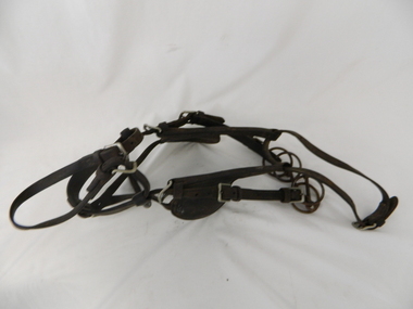
Bridle Horse, circa mid to late 1900's
... ...high country grazing...A scientific study started in 1947 to study the impact of grazing cattle/sheep on the natural Alpine and sub Alpine vegetation found grazing cattle had an adverse affect on the natural Alpine and sub alpine vegetation, and grazing on the plains was stopped by the Victorian Government in 2005.This "camp draft" on the Bogong High Plains could take up to six weeks. horse country leather bridle gaiters high country grazing cattlemen laces studs This harness bridle includes "blinders, winklers or blinkers" and would therefore be used on a pack or "working" horse. ...This stock horse bridle was probably used in the mid 1900's. This was the period when cattle and sheep mustering was at its prime. The movement of cattle and sheep was by mounted stock horse only and not by other methods. Northern territory cattle stations in the late 1900's started to use helicopters for "cattle control". In the KIEWA Valley/Bogong High Plains and other rural cattle/sheep producing areas required well trained stock horses and stockmen for cattle/sheep control. It is only in the later 1900's that motor bikes and four wheeled quad-bikes have taken over, in part, from the mounted stockman.This horse bridle is very significant to the Kiewa Valley because of the early introduction of cattle and sheep stations in what initially was regarded as a semi remote valley location. The maintenance of cattle and sheep in the Kiewa Valley was, and still is an important requirement of livestock management. A good stock horse bridle is important, especially during the period when cattle and sheep were grazed on the Bogong High Plains. The mustering and and moving cattle/sheep from the valley pastures to the high country was a demanding and dangerous exercise requiring "sure footed" stock horses.The "good specialised" bridle was a vital part of this cattle/sheep mustering. A scientific study started in 1947 to study the impact of grazing cattle/sheep on the natural Alpine and sub Alpine vegetation found grazing cattle had an adverse affect on the natural Alpine and sub alpine vegetation, and grazing on the plains was stopped by the Victorian Government in 2005.This "camp draft" on the Bogong High Plains could take up to six weeks.This harness bridle includes "blinders, winklers or blinkers" and would therefore be used on a pack or "working" horse. This bridle has rings on each end of the browband. The bridle is one used by a horse working in a team configuration pulling a heavy cart or wagon. The bridle has ten adjustable straps to allow it to accommodate a variety of horse sizes. See KVHS 0495 for a stock horse saddle.horse, country, leather bridle, gaiters, high country grazing, cattlemen, laces, studs -
 Kiewa Valley Historical Society
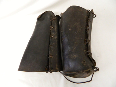
Gaiters Riding, Late 19th Century
... high plains and not so rugged mountain slopes. Small settlements such as Mount Beauty, Bogong village and Falls Creek provided a secure backdrop for short term horse back adventures. The increasing pressure of city life provided a greater flow of stressed out city dweller to find the peace and quiet that city life does not have. Horse riding preceded the modern trail bikes and other recreational vehicles of the late 1900s. horse country leather gaiters high grazing ...These gaiters where used circa 1800's to mid 1900's, by horse riders "cattle men" to protect their shins and long trousers against wear and tear. They were used rather than having expensive boots damaged. Gaiters were a lot easier to fasten and clean than boots. They were used in the Kiewa Valley and the High Plains grazing areas.These gaiters were part of a cattleman's "out fit". The Gaiters were easily cleaned and did away with expensive riding boots. They were used throughout the valley and high plains areas both by horse riders herding cattle and the recreational rider of both sexes. After the 1950s more recreational riders from Melbourne ventured onto the high plains and not so rugged mountain slopes. Small settlements such as Mount Beauty, Bogong village and Falls Creek provided a secure backdrop for short term horse back adventures. The increasing pressure of city life provided a greater flow of stressed out city dweller to find the peace and quiet that city life does not have. Horse riding preceded the modern trail bikes and other recreational vehicles of the late 1900s. Thick leather tapered gaiters with six metal Hooks and Leather lacing through metal eyelets. All bar two eyelets have a metal reinforced punch holes. Left gaiter missing most of lacing.horse, country, leather, gaiters, high, grazing, cattlemen, laces, studs -
 Kiewa Valley Historical Society
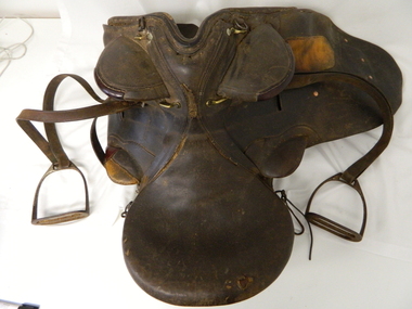
Saddle Horse Stock, Circa 1950
... grazed on the Bogong High Plains. The mustering and and moving cattle from the valley pastures to the high country was a demanding and dangerous exercise requiring "sure footed" stock horses.The "good" saddle was a vital part of this cattle mustering. ...This stock horse saddle was probably used in the mid 1900's. This was the period when cattle mustering was at its prime. The movement of cattle was by mounted stock horse only and not by other methods. Northern territory cattle stations in the late 1900's started to use helicopters for "cattle control". In the KIEWA Valley/Bogong High Plains and other rural cattle producing areas required well trained stock horses and stockmen for cattle control. It is only in the later 1900's that motor bikes and four wheeled quad-bikes have taken over, in part, from the mounted stockman.This horse saddle is very significant to the Kiewa Valley because of the early introduction of cattle stations in what initially was regarded as a semi remote location. The maintenance of cattle in the Kiewa Valley is and was an important requirement. A good stock horse saddle as and is important, especially during the period when cattle were grazed on the Bogong High Plains. The mustering and and moving cattle from the valley pastures to the high country was a demanding and dangerous exercise requiring "sure footed" stock horses.The "good" saddle was a vital part of this cattle mustering. A scientific study started in 1947 to study the impact of grazing cattle on the natural Alpine and sub Alpine vegetation found grazing cattle had an adverse affect on the natural Alpine and sub alpine vegetation, and grazing on the plains was stopped by the Victorian Government in 2005.This "camp draft" in the High Plains could take up to six weeks.This all leather "stock horse" saddle shows plenty of wear. It is in "full harness" configaration with stirrups and leg protectors horse, country, leather, gaiters, high, grazing, cattlemen, laces, studs -
 Kiewa Valley Historical Society
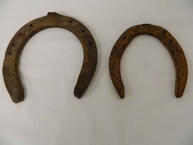
Shoes Horse Stock and Draft, early 1900's
... grazed on the Bogong High Plains. The mustering and and moving cattle from the valley pastures to the high country was a demanding and dangerous exercise requiring "sure footed" stock horses. ...These horse shoes (one a stock horse and one a draft horse) were probably used in the mid 1900's. They have been roughly made suggesting that a professional blacksmith was not instrumental in their manufacture. On smaller or remote cattle stations either the lead stock man or owner would "fire up" the kiln to provide the adjustments required to the horse shoe to ensure a "tight" fit. The larger cattle stations had a "professional" blacksmith to cover all their "working" horses. Larger properties eg.large Northern territory cattle stations use helicopters for "cattle control".These horse shoes are very significant to the Kiewa Valley because of the early introduction of cattle stations in what initially was regarded as a semi remote location. The maintenance of horses hooves is an important requirement, especially during the period when cattle were grazed on the Bogong High Plains. The mustering and and moving cattle from the valley pastures to the high country was a demanding and dangerous exercise requiring "sure footed" stock horses. A scientific study started in 1947 to study the impact of grazing cattle on the natural Alpine and sub Alpine vegetation found grazing cattle had an adverse affect on the natural Alpine and sub alpine vegetation, and grazing on the plains was stopped by the Victorian Government in 2005.This "camp draft" in the High Plains could take up to six weeks.Both these horse shoes have been "roughly" made but are specifically made for the type of horse which wore them. The smaller of the two is for the stock horse/riding horse and the lager one is for the larger draft horse. Each horse type has a specific role to play in the the type of activity it was used for. The small horse shoe has six "nail" holes for attachment to the horse hoof by special nails. The larger shoe has seven "nail" holes. Both have the three quarter moon shape which fits the curvature of the horses hooves. working horses, bogong high plains camp draft, grazing cattle bogong high plains -
 Kiewa Valley Historical Society
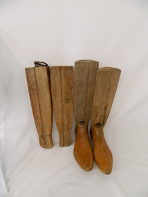
Stocks for Riding Boots, Late 1800's to early 1900's
... grazing cattle families to settle there. Both cattle and sheep properties occupied large areas of the Kiewa Valley and they also herded their flock and herd on the Bogong High Plains region. These stocks and boots were worn by Fred Roper whose great grand daughter donated them to KVHS. Therefore these boots and stocks would date from 1880's to 1920's and are a good representation of the style of boots worn during this period. horse. country ...These wooden trees for riding stocks are a concept that was brought to early colonial days from "mother" England. Gentle folk of wealth and status used these trees from early 1800's to keep and maintain their riding boots in their correct form. This form of maintaining the tall riding boot structure was maintained in Australia by the rural "elite" both on cattle properties and smaller cattle stations in the early 1900's. Good riding boots were a status symbol in rural and outback Australia. The riding stocks "wooden trees" are very significant in the Kiewa Valley because they were used by members of some of the original grazing cattle families to settle there. Both cattle and sheep properties occupied large areas of the Kiewa Valley and they also herded their flock and herd on the Bogong High Plains region. These stocks and boots were worn by Fred Roper whose great grand daughter donated them to KVHS. Therefore these boots and stocks would date from 1880's to 1920's and are a good representation of the style of boots worn during this period. This pair of wooden stocks for riding boots trees has been manufactured to a very high standard. Each of the four boot tree parts fit snugly together and maintain their form, and that of the boot that they occupy. The groove channels and foot forms (tongue and groove) are exact and once snapped together become very solid. There is a brass ring, attached by a small brass "peg" on each of the thin "sliding" middle uprights. See KVHS 0177 - Riding boots.On top "L" (for left boot), "R" (for right boot)horse. country. leather. gaiters. high plains. grazing. cattlemen. laces. studs. stocks. roper family. bogong high plains. -
 Eltham District Historical Society Inc
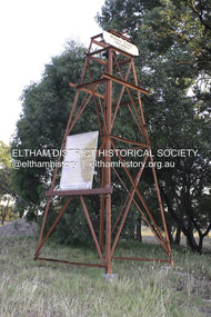
Photograph - Digital Photograph, Alan King, Golden King Mine poppet-head, Yarrambat Primary School, 1 February 2008
... grazed their sheep and cattle. Yarrambat was then known as Tanck’s Corner or Reynolds Corner, after wood carter, Frederick Tanck, who owned land north of Ironbark Road, at the corner of Yan Yean Road, and Thomas Reynolds, owner of the opposite property. After Reynolds sold his land, the corner became known as Tanck’s Corner. In 1929 the district’s name was changed to Yarrambat, believed to mean ‘high hill’ in the Wurundjeri language. Tanck’s Corner was in the centre of gold-bearing country...grazed their sheep and cattle. Yarrambat was then known as Tanck’s Corner or Reynolds Corner, after wood carter, Frederick Tanck, who owned land north of Ironbark Road, at the corner of Yan Yean Road, and Thomas Reynolds, owner of the opposite property. After Reynolds sold his land, the corner became known as Tanck’s Corner. In 1929 the district’s name was changed to Yarrambat, believed to mean ‘high hill’ in the Wurundjeri language. Tanck’s Corner was in the centre of gold-bearing country ...The Golden King Mine poppet-head stands at the school’s Yan Yean Road exit gate. Published: Nillumbik Now and Then / Marguerite Marshall 2008; photographs Alan King with Marguerite Marshall.; p23 Early Yarambat - Tanck's Corner Its early settlers, who in the 1840s were amongst the first non-Aboriginal people in the area, found life tough as they grazed their sheep and cattle. Yarrambat was then known as Tanck’s Corner or Reynolds Corner, after wood carter, Frederick Tanck, who owned land north of Ironbark Road, at the corner of Yan Yean Road, and Thomas Reynolds, owner of the opposite property. After Reynolds sold his land, the corner became known as Tanck’s Corner. In 1929 the district’s name was changed to Yarrambat, believed to mean ‘high hill’ in the Wurundjeri language. Tanck’s Corner was in the centre of gold-bearing country and the district is honeycombed with old tunnels and shafts. However although gold played a dominant role for decades, there was insufficient to develop a substantial township. Meat and agricultural produce made a greater impact. Until the mid-20th century the only substantial building was the primary school. The first gold rush occurred around 1860, the second after 1900; then during the Depression, the Government paid men to pan for gold. The first rush attracted hundreds of Chinese people to Smugglers Gully, who constructed round diggings to keep away spirits. Alluvial miners lived along the Plenty River in tents or humpies - some fenced with gardens - and some miners distilled their own ‘plonk’. It was a wild time and bushrangers - and later gangster Squizzy Taylor - were said to hide4 in the old Pioneer Tunnel in Dunne’s Gully between Heard Avenue and Pioneer Road. Mines opposite Tanck’s Corner included Beer’s Line, Golden Crown and Golden Stairs. Some of the big mines had batteries and stampers to process quartz. At first there was plenty of alluvial gold, as much as two ounces to the ton. At times gold was exposed after heavy rains so fossickers panned for gold around orchard irrigation trenches. Gold was mined until 1984 when Yarrambat’s last operating goldmine, the Golden King Mine, in North Oatlands Road, closed. The Clayton family operated it full-time, making a comfortable living and in the 1960s it was the only private family gold mine in Victoria.5 Gold was such an important part of Yarrambat’s history that a gold poppet-head is the Yarrambat Primary School’s logo. The Golden King Mine poppet-head stands at the school’s Yan Yean Road exit gate. However this school was built in 1988. The original school No 2054, at the corner of Ironbark and Yan Yean Roads, was opened in 1878 and modified to its present form in the 1920s. In 2000 it was relocated to the Heritage Museum at Yarrambat Park.7 The school, whose first head teacher was Charles Planner, consisted of one room with a three-roomed residence. The school was also the community centre. On Saturday nights it was crammed for dances or euchre parties, community singing or other social events. On Sundays, services for different denominations took turns each week. However the school had its teething problems. Parents accused Charles Planner of neglecting his duties and the school closed several times. When it closed in 1892, only church services continued. Social activities moved elsewhere, such as the tennis club to the Stuchbery tennis court opposite. A sports day and woodchop on Boxing Day around 1900 was held at the Evelyn Hill Hotel, also called Evelyn Arms and Tunnel Hill Hotel, on the Greensborough–Diamond Creek Road. An annual agricultural show in Diamond Creek paraded through the town, and New Year’s Day picnics at the Yan Yean Reservoir included highland dancing and competitions. Also popular were the Indian hawkers who visited every three months, selling trinkets, clothing and other items. One called Jimmy ‘Allem dem Bedi’, gave presents and told stories, played draughts and sold delicious curries he cooked over his camp fire at night.This collection of almost 130 photos about places and people within the Shire of Nillumbik, an urban and rural municipality in Melbourne's north, contributes to an understanding of the history of the Shire. Published in 2008 immediately prior to the Black Saturday bushfires of February 7, 2009, it documents sites that were impacted, and in some cases destroyed by the fires. It includes photographs taken especially for the publication, creating a unique time capsule representing the Shire in the early 21st century. It remains the most recent comprehenesive publication devoted to the Shire's history connecting local residents to the past. nillumbik now and then (marshall-king) collection, golden king mine, tanck's corner, yarrambat primary school -
 Kiewa Valley Historical Society
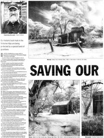
Newspaper article- Double page article. Pages 30 & 83 from the Herald Sun Newspaper. February 18, 2006 regarding preserving Victoria’s High Country Huts
... The arrival of explorers Hume & Hovell in 1842 brought about the widespread clearing of land in the valleys for pastoral uses and the displacement the original inhabitants in the high country which became a boon for cattlemen due to extensive lush summer grazing for cattle. ...The arrival of explorers Hume & Hovell in 1842 brought about the widespread clearing of land in the valleys for pastoral uses and the displacement the original inhabitants in the high country which became a boon for cattlemen due to extensive lush summer grazing for cattle. ...The arrival of explorers Hume & Hovell in 1842 brought about the widespread clearing of land in the valleys for pastoral uses and the displacement the original inhabitants in the high country which became a boon for cattlemen due to extensive lush summer grazing for cattle. High country cattlemen built a variety of huts for shelter and storage, when driving cattle up to the plains in summer, during mustering and bringing the cattle down from the mountains before winter closed in. These same huts now provide shelter from the elements for hikers, bush walkers and skiers. Wallace’s Hut is the oldest of the Cattleman’s huts still standing in the Alpine National Park and is classified under the National Trust. Due to their age and the ravages of the elements, including bush fires, many of the huts have been destroyed, or are falling into disrepair. Groups of willing volunteers are now working to preserve as many of the huts as possible with restoration or rebuilding.The numerous cattleman’s huts of the Alpine National Park and the colourful characters who erected them represent a significant part of the history of the high country area and early cattle grazing, which has been the theme for many poets and film-makers alike. They also have a significant role in the early days of the SECV when they were used by surveyors and other workers for shelter and temporary accommodation. More recently the huts have functioned as shelter for hikers and skiers caught out in the elements and a refuge along the long trek for bush walkers. They are a popular attraction for tourists and feature prominently in much of the tourist information of the region. Black and white double page Newspaper article from the Herald Sun Newspaper of February 18, 2006 regarding the efforts of Mr David Oldfield to preserve Victoria’s remaining High Country Huts through his photography and efforts to restore old and Re-build missing ones. Article shows a photograph of David Oldfield and some of his photographic work of the huts. Page number and date printed at top of each page 30 Herald Sun, Saturday, February 18, 2006 Herald Sun, Saturday, February 18, 2006 83 cattlemen's huts; david oldfield; bogong high plains; wallace's hut; high country; alpine national park -
 Kiewa Valley Historical Society
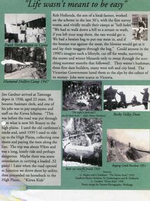
Posters – Set of 3 A4 posters depicting the early days and people in the Kiewa Valley
... They also highlight the early arguments regarding grazing in the high country which would ultimately lead to the end of the long traditions of the high country cattle men. kiewa valley; tourism; lifestyles Printed on each poster – Poster designed by Dyanne Photography - Wodonga 1. ...In the 1830’s, European pastoralists started moving south from NSW into the Alps. In 1836, cattle grazing began around Omeo and the runs spread out into the foothills. The higher country was used for summer grazing and huts were built for shelter and storage during stock mustering. The lure of gold brought many people to the Alps from around 1850 to 1900. Bushfires destroyed the forests around Melbourne in 1939 and the boom in house-building after World War II ked to increased demand for timber from the Alps. This resulted in the building of a network of roads which helped open up access to the Alps. The early 1940’s brought the first of many workers to the Alps for the planning and construction of the Hydro-Electric Scheme. These were the pioneers and early settlers of the Kiewa Valley and provided a wealth of characters and a tapestry of stories and adventures to be handed down to future generations.These 3 posters, which were most likely produced for promotional purposes provide a glimpse into the early lives of the pioneer families of the Kiewa Valley through pictures and verse. They show their lifestyle and outline the hardships they had to endure in living and working in the Alpine region. They also highlight the early arguments regarding grazing in the high country which would ultimately lead to the end of the long traditions of the high country cattle men. Set of 3 A4 size posters with black and white photographs and text and colour background depicting various parts of the history of the Kiewa Valley. 1. Titled - ‘Life wasn’t meant to be easy’ Describes early life for Kiewa Hydro workers. 2. Titled - ‘Cattlemen of the High Plains’ Describes a brief history of life of the cattlemen of the high plains 3. Titled – ‘There are Places I’ll remember’ Depicts early photographs of residents of the Kiewa Valley, also includes the words from a John Lennon song as per poster title. Printed on each poster – Poster designed by Dyanne Photography - Wodonga 1. Printed at bottom of poster – Sources: G Napier and G Easdown “The Kiewa Story” 1993. Southern Hydro Archives, N Hetherington and R Hollands. G Gardner “The Kiewa Kids” 1998. 2. Printed at bottom of poster – Sources: D Purland. Handwritten at top of poster- Poster 4 3. Printed at bottom of poster – Sources: B Roper, W Davies, D Higginson, H Ryder. Handwritten at top of poster- Poster 3 kiewa valley; tourism; lifestyles -
 Kiewa Valley Historical Society
Roper's Hut Memorabilia
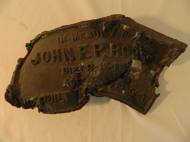
... It was rebuilt in 2008 and is situated on the Bogong High Plains on Duane Spur (where Duane's hut had been before it too was destroyed by (1939) bushfires, between Mt Nelse and Big River. The original hut was used as a shelter for cattlemen who grazed their cattle on the High Plains during summer. The Victorian High Country...It was rebuilt in 2008 and is situated on the Bogong High Plains on Duane Spur (where Duane's hut had been before it too was destroyed by (1939) bushfires, between Mt Nelse and Big River. The original hut was used as a shelter for cattlemen who grazed their cattle on the High Plains during summer. The Victorian High Country ...Roper's Hut was built in 1939 and was burnt down in 2003. It was rebuilt in 2008 and is situated on the Bogong High Plains on Duane Spur (where Duane's hut had been before it too was destroyed by (1939) bushfires, between Mt Nelse and Big River. The original hut was used as a shelter for cattlemen who grazed their cattle on the High Plains during summer. The Victorian High Country Huts Association Inc. members and friends helped rebuild the hut which is now used as an emergency shelter for visitors to the High Plains.The memorabilia is significant as the items belonged to the Roper family who were one of the original settlers of the Kiewa Valley and one of the original families who drove their cattle up to the Bogong High Plains. The burnt plaque and forks and the rebuilding of the huts (Duane's & Roper's) are significant as bush fires are a constant threat to the Bogong High Plains destroying large areas at a time.1. Bronze Plaque and 2 damaged forks from Roper's Hut which was destroyed by bush fires in 2003. 2. DVD & USB and hard copy photos of the rebuild of Roper's Hut in January 2008.The plaque had 'In Memory of / John F. P. Roper/ died 3-12-1977 / Aged 78 years / He built the original hut Feb. 1939'roper's hut, cattlemen, bogong high plains, bronze plaque, roper family, bush fires -
 Falls Creek Historical Society
Photograph - Ray Meyer at Roper's Hut
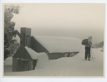
... grazed the Bogong High Plains from the 1890s until 1908. Frederick "Jack" built three huts. The hut known as Roper’s Hut was built on Jack's new grazing lease after his former run had been acquired by the SEC in the late 1930s. It had become a well-used refuge hut prior to its destruction in the 2003 bushfires. It was rebuilt by Victorian High Country...grazed the Bogong High Plains from the 1890s until 1908. Frederick "Jack" built three huts. The hut known as Roper’s Hut was built on Jack's new grazing lease after his former run had been acquired by the SEC in the late 1930s. It had become a well-used refuge hut prior to its destruction in the 2003 bushfires. It was rebuilt by Victorian High Country ...MEYER COLLECTION - FALLS CREEK PHOTOS In 1947 a determined group of like-minded State Electricity Commission (SEC) staff including Ray Meyer, the chief surveyor of the Kiewa Hydro-Electric Scheme, had a common interest that revolved around the skiing potential of the snow-covered high plains which included what is now the resort of Falls Creek. The six SEC employees, Toni St Elmo, Ray Meyer, Jack Minogue, Lloyd Dunn, Adrian Ruffenacht and Dave Gibson (together with their families) banded together to secretly build a 'hut' that was the first ski lodge at Falls Creek. Using a road built in 1930s to gain access to Falls Creek, their hut project was carried out in secret as efforts by other skiers were blocked by H.H.C. Williams – the engineer in charge of the Hydro Scheme. In 1946 Ray Meyer made a trip to the Lands Office in Melbourne. He came away with a 99-year lease on three acres that was ideally suited for a hut designed by Lloyd Dunn. Adrian Ruffenacht (Design Engineer for the KHS) had suggested where the group should build because of easy access to a spring for water. Much of the building material required was scavenged from derelict huts on the high plains. Due to the need for secrecy, the determined group worked on the hut in the evenings and weekends to avoid detection. During the building period the group had met at Echidna Rock (now known as Eagle Rock) where Skippy St Elmo announced, "This is my favourite ‘Skyline’.” And so the first lodge in the area at Falls Creek Ski Resort came into existence. With the development of the International Poma in the 1970s, the Skyline Lodge, which was sited between the ski-lift’s pole one and pole two, was demolished. However, the legacy of Ray Meyer, Toni St Elmo, Jack Minogue, Lloyd Dunn, Adrian Ruffenacht and Dave Gibson and Skyline lives on in the vibrant atmosphere of Falls Creek Resort. The MEYER COLLECTION documents developments on the Kiewa Hydro Scheme and their life at Falls Creek from the mid 1930s to 1960s.These images are significant because they depict aspects of the life of a pioneering family of Falls Creek and the founders of "Skyline", the first lodge at Falls Creek.Two black and white images of Ray Meyer outside Roper's Hut. Frederick Roper and his family grazed the Bogong High Plains from the 1890s until 1908. Frederick "Jack" built three huts. The hut known as Roper’s Hut was built on Jack's new grazing lease after his former run had been acquired by the SEC in the late 1930s. It had become a well-used refuge hut prior to its destruction in the 2003 bushfires. It was rebuilt by Victorian High Country Huts Association in 2008.falls creek, building skyline, skyline founders, toni st elmo, adrian ruffenacht, jack minogue, ray meyer, lloyd dunn, david gibson -
 Falls Creek Historical Society
Photograph - Bogong Trip 1951- Mt. Bogong from above Roper's Hut
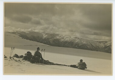
... grazed the Bogong High Plains from the 1890s until 1908. Frederick "Jack" built three huts. The hut known as Roper’s Hut was built on Jack's new grazing lease after his former run had been acquired by the SEC in the late 1930s. It had become a well-used refuge hut prior to its destruction in the 2003 bushfires. It was rebuilt by Victorian High Country...High Plains Wal Johnson Ray Meyer Ropers Hut Black and White Image of Mt. Bogong from above Roper's Hut with Wal Johnson and Ray Meyer seated on the ground. ROPER'S HUT Frederick Roper and his family grazed the Bogong High Plains from the 1890s until 1908. Frederick "Jack" built three huts. The hut known as Roper’s Hut was built on Jack's new grazing lease after his former run had been acquired by the SEC in the late 1930s. It had become a well-used refuge hut prior to its destruction in the 2003 bushfires. It was rebuilt by Victorian High Country ...MEYER COLLECTION - FALLS CREEK PHOTOS In 1947 a determined group of like-minded State Electricity Commission (SEC) staff including Ray Meyer, the chief surveyor of the Kiewa Hydro-Electric Scheme, had a common interest that revolved around the skiing potential of the snow-covered high plains which included what is now the resort of Falls Creek. The six SEC employees, Toni St Elmo, Ray Meyer, Jack Minogue, Lloyd Dunn, Adrian Ruffenacht and Dave Gibson (together with their families) banded together to secretly build a 'hut' that was the first ski lodge at Falls Creek. Using a road built in 1930s to gain access to Falls Creek, their hut project was carried out in secret as efforts by other skiers were blocked by H.H.C. Williams – the engineer in charge of the Hydro Scheme. In 1946 Ray Meyer made a trip to the Lands Office in Melbourne. He came away with a 99-year lease on three acres that was ideally suited for a hut designed by Lloyd Dunn. Adrian Ruffenacht (Design Engineer for the KHS) had suggested where the group should build because of easy access to a spring for water. Much of the building material required was scavenged from derelict huts on the high plains. Due to the need for secrecy, the determined group worked on the hut in the evenings and weekends to avoid detection. During the building period the group had met at Echidna Rock (now known as Eagle Rock) where Skippy St Elmo announced, "This is my favourite ‘Skyline’.” And so the first lodge in the area at Falls Creek Ski Resort came into existence. With the development of the International Poma in the 1970s, the Skyline Lodge, which was sited between the ski-lift’s pole one and pole two, was demolished. However, the legacy of Ray Meyer, Toni St Elmo, Jack Minogue, Lloyd Dunn, Adrian Ruffenacht and Dave Gibson and Skyline lives on in the vibrant atmosphere of Falls Creek Resort. The MEYER COLLECTION documents developments on the Kiewa Hydro Scheme and their life at Falls Creek from the mid 1930s to 1960s.This image is significant because it depicts aspects of the life of a pioneering family of Falls Creek and the founders of "Skyline", the first lodge at Falls Creek.Black and White Image of Mt. Bogong from above Roper's Hut with Wal Johnson and Ray Meyer seated on the ground. ROPER'S HUT Frederick Roper and his family grazed the Bogong High Plains from the 1890s until 1908. Frederick "Jack" built three huts. The hut known as Roper’s Hut was built on Jack's new grazing lease after his former run had been acquired by the SEC in the late 1930s. It had become a well-used refuge hut prior to its destruction in the 2003 bushfires. It was rebuilt by Victorian High Country Huts Association in 2008.falls creek, bogong high plains, wal johnson, ray meyer, ropers hut -
 Falls Creek Historical Society
Book - Cattlemen of the High Country, Tor and Jane Holth, 2008
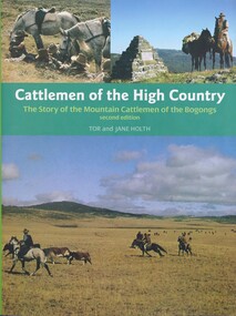
... grazing and the struggle of the mountain cattlemen to retain their leases after the bushfires of 2003. This publication provides an enduring record of a special group of Australian pioneers whose lives and qualities of endurance have become part of Australian folklore. Subtitled "The story of the mountain cattlemen of the Bogongs", this publication of 248 pages includes illustrations, photos, portraits, an index and maps on the end papers. The original edition was published in 1980 Cattlemen of the High Country ...A history of the cattlemen of the Bogongs in the Victorian Alps, including their bushcraft, yarns, hut construction, dog and horse training. It looks at the issue of fire and cattle grazing and the struggle of the mountain cattlemen to retain their leases after the bushfires of 2003. This publication provides an enduring record of a special group of Australian pioneers whose lives and qualities of endurance have become part of Australian folklore.Subtitled "The story of the mountain cattlemen of the Bogongs", this publication of 248 pages includes illustrations, photos, portraits, an index and maps on the end papers. The original edition was published in 1980 A history of the cattlemen of the Bogongs in the Victorian Alps, including their bushcraft, yarns, hut construction, dog and horse training. It looks at the issue of fire and cattle grazing and the struggle of the mountain cattlemen to retain their leases after the bushfires of 2003. This publication provides an enduring record of a special group of Australian pioneers whose lives and qualities of endurance have become part of Australian folklore.bogong high plains, cattlemen of the high plains, bogong high plains history
