Showing 61 items matching "mt beauty land"
-
 Kiewa Valley Historical Society
Papers - Hollonds' Family and their memories, 2013
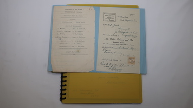
... ...mt beauty land...These papers describe the connection to the families and the Kiewa Valley. hollonds family tawonga station cattlemen mt beauty land tawonga boarding house Typed papers donated by the Hollonds' family covering: The Hollonds Family History, Cattlemen, 'Snowy' Miller, Mrs Hollonds' Boarding house, SEC Depot at Tawonga, building of Bogong Township, Early Scenes on the Kiewa Scheme. ...The Hollonds' family were original settlers in the Kiewa Valley at Mulagong. Their descendants owned land in Tawonga, Tawonga South and between the East and West of the Kiewa river. Hollonds had a cattle run on Mt Fainter which was later given to the Hicks family.Members of the Hollonds family lived, worked and married in the Kiewa Valley. These papers describe the connection to the families and the Kiewa Valley.Typed papers donated by the Hollonds' family covering: The Hollonds Family History, Cattlemen, 'Snowy' Miller, Mrs Hollonds' Boarding house, SEC Depot at Tawonga, building of Bogong Township, Early Scenes on the Kiewa Scheme.hollonds family, tawonga station, cattlemen, mt beauty land, tawonga boarding house -
 Kiewa Valley Historical Society
Papers - Mt Beauty Airport Development
... The SECV began investigating four possible sites for an airstrip in Mt Beauty in 1965. The land was owned by the SEC and leased by Mr J. ...Kiewa Valley Historical Society Mount Beauty Information Centre 31 Bogong High Plains Rd Mt Beauty high-country The SECV began investigating four possible sites for an airstrip in Mt Beauty in 1965. The land ...The SECV began investigating four possible sites for an airstrip in Mt Beauty in 1965. The land was owned by the SEC and leased by Mr J. Sharp. It became available on the condition that the land would only be available to the Municipal shire. This land was officially opened as an Airport as an official tourist activity in 1977. It continues to be available to tourists, fire fighters, the air ambulance and the local gliding club.The opening of Mt Beauty Airport has enhanced Mt Beauty township by enabling fire fighters to access the surrounding bush during bush fires, by enabling Ambulance helicopters to rush emergency patients to city hospital, by giving tourists the opportunity to fly in and to give the local Gliding Club the opportunity to store and fly their gliders. 1. Set of papers titled 'History Mt Beauty Airport Development' held together by large steel clip by Alex McCullough. 2. Set of papers titled 'Department of Transport' and 'Alpine Shire' both held together by one staple. 3.Mt Beauty Township Survey Plan of Airstrip 1975 4. Large folder titled Mr J. R. Sharp 1975 - Mt Beauty Airfieldmt beauty airport history, alex mccullough, transport, tourism -
 Kiewa Valley Historical Society
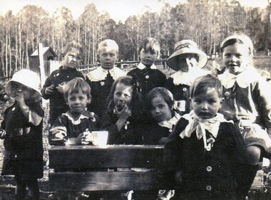
Photo - Tawonga Primary School pupils 1920, 1920
... Mt Beauty high-country Tawonga Primary School Children 1920. Tawonga is in the Kiewa Valley where farmers lived with their families. The school was opened on 27th July 1880 situated on 8 acres near the current township of Tawonga. This school was erased by fire in 1900 and all records were destroyed. The school then moved to the old Tawonga Hall. In 1910 the school was shifted to its present site on 3 acres of land ...Tawonga Primary School Children 1920. Tawonga is in the Kiewa Valley where farmers lived with their families. The school was opened on 27th July 1880 situated on 8 acres near the current township of Tawonga. This school was erased by fire in 1900 and all records were destroyed. The school then moved to the old Tawonga Hall. In 1910 the school was shifted to its present site on 3 acres of land donated by Frank Cooper. The school building and attendance continued to grow especially during the construction of the Kiewa Hydro Electric Scheme. Early residents of the area. Ellie Seymour front row first on left. Walter J E Ryder in front of the desk at right. Vera Ryder behind him on the right. The boys also wore white collarsCopy of black and white photograph of pupils (children) at Tawonga Primary School 1920tawonga primary school, state school, kiewa valley -
 Kiewa Valley Historical Society
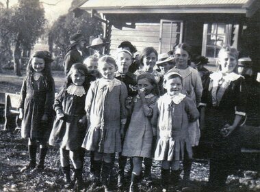
Photo - School Children Tawonga Primary School, Circa 1920 (estimate)
... Mt Beauty high-country Tawonga is in the Kiewa Valley, where local farmers lived with their families. The school was originally opened July 27 1880, situated on 8 acres near the current township of Tawonga. The school was erased by fire in 1900 and all records destroyed. The school was then moved to the Old Tawonga Hall. In 1910, the school was shifted to its present site on 3 acres of land ...Tawonga is in the Kiewa Valley, where local farmers lived with their families. The school was originally opened July 27 1880, situated on 8 acres near the current township of Tawonga. The school was erased by fire in 1900 and all records destroyed. The school was then moved to the Old Tawonga Hall. In 1910, the school was shifted to its present site on 3 acres of land donated by Frank Cooper. The school building and attendance continued to grow, especially during construction of the Kiewa Hydro Electric Scheme.Tawonga Primary School has educated the local farming and town children for many years. It is an excellent source of the names of the local families of the time ie: Vera Ryder – front row, far right (little girl with the wide headband.)Copy of black and white photograph of pupils at Tawonga Primary School. Circa 1920 (estimate)tawonga primary school, kiewa valley -
 Kiewa Valley Historical Society
Photo - School Children Tawonga Primary School, Circa 1920 (estimate)
... Mt Beauty high-country Tawonga is in the Kiewa Valley, where local farmers lived with their families. The school was originally opened July 27 1880, situated on 8 acres near the current township of Tawonga. The school was erased by fire in 1900 and all records destroyed. The school was then moved to the Old Tawonga Hall. In 1910, the school was shifted to its present site on 3 acres of land ...Tawonga is in the Kiewa Valley, where local farmers lived with their families. The school was originally opened July 27 1880, situated on 8 acres near the current township of Tawonga. The school was erased by fire in 1900 and all records destroyed. The school was then moved to the Old Tawonga Hall. In 1910, the school was shifted to its present site on 3 acres of land donated by Frank Cooper. The school building and attendance continued to grow, especially during construction of the Kiewa Hydro Electric Scheme.Tawonga Primary School has educated the local farming and town children for many years. It is an excellent source of the names of the local families of the time. Copy of black and white photograph of pupils at Tawonga Primary School. Circa 1920 (estimate)tawonga primary school, kiewa valley -
 Kiewa Valley Historical Society
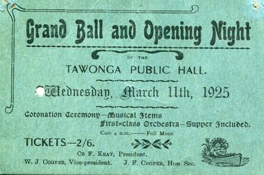
Printed Ticket - for Tawonga Public Hall opening night, Prior to March 11, 1925
... Mt Beauty high-country The first Tawonga Public Hall was opened in grand style with a Grand Ball and Opening Night with musical items, a first class orchestra and supper included. All costing 2/6 The old hall was demolished after the 'new' one was built and being used demonstrating that a hall was considered a necessary community facility for the town This was the first public hall in Tawonga. On the ticket, W.J. Cooper was Vice President and J.F Cooper was Hon Secretary. Coopers were a prominent name in the early days of Tawonga. Frank Cooper donated the land ...The first Tawonga Public Hall was opened in grand style with a Grand Ball and Opening Night with musical items, a first class orchestra and supper included. All costing 2/6 The old hall was demolished after the 'new' one was built and being used demonstrating that a hall was considered a necessary community facility for the townThis was the first public hall in Tawonga. On the ticket, W.J. Cooper was Vice President and J.F Cooper was Hon Secretary. Coopers were a prominent name in the early days of Tawonga. Frank Cooper donated the land which the present Tawonga Primary School is built on.Printed ticket on green card for Grand Ball and Opening Night of the Tawonga Public Hall. Wednesday March 11, 1925. Ticket is punched presumably as proof of admittancetawonga public hall; grand ball opening; ticket; cooper family -
 Kiewa Valley Historical Society
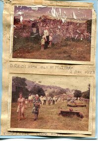
Photographs x 2- D Reids home at Mill Park 1973, 2/12/1973
... Kiewa Valley Historical Society Mount Beauty Information Centre 31 Bogong High Plains Rd Mt Beauty high-country David Reid (1820-1906) was a pastoralists and politician. He left school at 16 and after meeting the overlander John Gardiner he decided to look for land south of the Murray River. ...David Reid (1820-1906) was a pastoralists and politician. He left school at 16 and after meeting the overlander John Gardiner he decided to look for land south of the Murray River. Equipped by his father with some 500 head of cattle, 2 bullock wagons and teams and 6 assigned servants, he reached the Ovens River on 8 September 1838. David settled at Currargarmonge, near Wangaratta. At the end of 1843 he took up land near Yackandandah. In 1847 he took up a section of the family run of which Woorajay (Wooragee) formed a part. He built the first water driven flour-mill in the district on his Yackandandah run in 1845; his woolclip of 1848 was one of the first to be handled by R. Goldsbrough and was claimed to come from sheep descended from stock imported in the 1820s from George III's flock. Going into politics, he held the Legislative Assembly seat of Murray from October 1859 to May 1862. David Reid was a highly regarded grazier and local politician who was significantly involved in settlement around the Yackandandah area. Photo demonstrates ongoing interest in the local history of the area and its early residents2 colour photographs mounted together on buff card 1. Man and 2 children (unidentified) standing outside the remains of the Reid home. 2 Dec, 1973 2. Group of unidentified people on a tour of the old homestead of D. Reid. 2 Dec, 19731. Handwritten in black ink under photo 'D. Reid's home 1845. At Mill Park. 2 Dec 1973 2. Handwritten in blue ink under photo 'Snapshots Clare Roper"clare roper -
 Kiewa Valley Historical Society
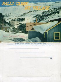
Souvenir Postcard Folder – Falls Creek Ski Village
... Kiewa Valley Historical Society Mount Beauty Information Centre 31 Bogong High Plains Rd Mt Beauty high-country After World War II, the Kiewa Hydroelectric Scheme was started in the Kiewa River valley by the State Electricity Commission of Victoria. On land ...After World War II, the Kiewa Hydroelectric Scheme was started in the Kiewa River valley by the State Electricity Commission of Victoria. On land previously used only for summer cattle grazing in the natural alpine grasslands, the first ski lodge was built in 1948 by workers from the scheme. The first lift, a rope tow, was built in 1951 and the first chairlift in Australia was constructed there in 1957. Falls Creek Post Office opened on 9 June 1958 (with telegraph and telephone facilities only until 1964) .Despite strong opposition from the head of the Kiewa scheme, who didn't want tourists clogging up his roads and destroying his "dry" construction camps by bringing in booze, Falls Creek boomed as much as Hotham, partly owing to its relatively good access road. Early lodges included Bogong (c.1946), Skyline (1947), Albury (1949), Myrtleford (1949) and Dawn (c.1950).The souvenir postcard photographed and produced by an enterprising local businessman Mr S K Pearce, was produced as a memento for skiers and other visitors to the Falls Creek and Mt Beauty area to send to family and friends as a reminder of their visit to the region, or to keep as a personal souvenir. It presented an excellent promotional opportunity for enterprising local businessmen to promote the area to skiers and tourists near and far. It also presents an excellent pictorial history of the falls creek area around the late 1950’s to early 1960’sColour postcard folder (unused) containing 13 photographs of the Falls Creek ski area and surrounds. Inside cover has a brief description of the area and the services available to visitors Printed on front cover- FALLS CREEK SKI VILLAGE. Your Souvenir Folder Photo of skiing slopes of the village Inside front flap - a brief description of the Falls Creek area and the services available to visitors 1. Diana Lodge parking area and Spion Kopje 2. Winterhaven Lodge 3. Ski Hirage Centre and skiing slopes 4. Ski Lodges from main road 5. Nelse and Arundel Lodges 6. Day visitors’ shelter and parking area 7. Summit T-Bar lift 8. Spur T-bar looking towards Village and Spion Kopje 9. T-bar lower station and Snow Crystal Inn 10. ‘Akja’ rescue sled in use 11. Falls Creek road and Grand Coeur Lodge annex 12. Rope tows and beginner slopes 13. Back cover- Published by Nucolorvue Pty Ltd Mentone Vic. Printed in Australia For S.K.Pearce Pty Ltd Tawonga and Mt Beauty falls creek, snow, bogong high plains, victorian alps -
 Kiewa Valley Historical Society
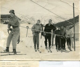
Photographs – Skiers at Falls Creek – Set of 10 black and white photographs
... Kiewa Valley Historical Society Mount Beauty Information Centre 31 Bogong High Plains Rd Mt Beauty high-country After World War II, the Kiewa Hydro-Electric Scheme was started in the Kiewa River valley by the State Electricity Commission of Victoria. On land ...After World War II, the Kiewa Hydro-Electric Scheme was started in the Kiewa River valley by the State Electricity Commission of Victoria. On land previously used only for summer cattle grazing in the natural alpine grasslands, the first ski lodge was built in 1948 by workers from the hydro scheme as skiing was a popular recreation. Many of the hydro employees were of European background and had grown up enjoying skiing and snow sports in their homelands and were keen to continue to pursue their winter sports interests. The first lift, a rope tow, was built in 1951 and the first chairlift in Australia was constructed there in 1957. Two T-Bars were opened in 1961. In 1964, the Victorian Municipal Directory recorded that Falls Creek had 29 ski club lodges and 16 commercial lodges.Employees of the State Electricity Commission of Victoria in the Kiewa River Valley were the earliest skiers on the Bogong High Plains and built one of the first ski lodges at Falls Creek. They were amongst those pivotal in the development of the skiing and tourist industry at Falls Creek and on the Bogong High Plains. Set of 10 black and white photographs of various skiers at Falls Creek Victoria1. From Left-John Robertson Myrtleford; Bill Bridgford, St Trinians; Girl not known; Roy Wolpole, Myrtleford; Fin McAuliffe, Myrtleford; Looking on foreground, Toni St Elmo 2. Falls Creek. Property of State Electricity Commission of Victoria Publicity Photo Negative No PB4046. Publicity Branch, 15 William St Melbourne. 3. Avic Lajons 4. No markings 5. Bill Bridgeford (lower person on slope) 6. Max Lawrence? Facing skiers 7. 6575. Indistinguishable red stamp on back 8. 6875. Ces Dobson on tractor 9. From left on tow. John Robertson (Myrtleford); Bill Bridgeford (St Trinians); Girl unknown; Roy Walpole (Myrtleford); Vin McAuliffe (Myrtleford); Looking on foreground Toni Beveridge. 10. From Left 1; 2; 3. Bill Bridgeford; 4. George McPherson ? (Myrtleford); 5. John Robertson (Myrtleford); 6. Elsbeth Rollenson? (Myrtleford); 7; 8; 9. 11. Bogong. Looking N.E from Big River fire track. Skiers on way to Falls Creek. Spion Kop on left. Going around Ropers Cerner near the 18 mile post falls creek, skiing, bogong high plains -
 Kiewa Valley Historical Society
Newspaper article- Double page article. Pages 30 & 83 from the Herald Sun Newspaper. February 18, 2006 regarding preserving Victoria’s High Country Huts
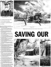
... Kiewa Valley Historical Society Mount Beauty Information Centre 31 Bogong High Plains Rd Mt Beauty high-country The arrival of explorers Hume & Hovell in 1842 brought about the widespread clearing of land in the valleys for pastoral uses and the displacement the original inhabitants in the high country which became a boon for cattlemen due to extensive lush summer grazing for cattle. ...The arrival of explorers Hume & Hovell in 1842 brought about the widespread clearing of land in the valleys for pastoral uses and the displacement the original inhabitants in the high country which became a boon for cattlemen due to extensive lush summer grazing for cattle. High country cattlemen built a variety of huts for shelter and storage, when driving cattle up to the plains in summer, during mustering and bringing the cattle down from the mountains before winter closed in. These same huts now provide shelter from the elements for hikers, bush walkers and skiers. Wallace’s Hut is the oldest of the Cattleman’s huts still standing in the Alpine National Park and is classified under the National Trust. Due to their age and the ravages of the elements, including bush fires, many of the huts have been destroyed, or are falling into disrepair. Groups of willing volunteers are now working to preserve as many of the huts as possible with restoration or rebuilding.The numerous cattleman’s huts of the Alpine National Park and the colourful characters who erected them represent a significant part of the history of the high country area and early cattle grazing, which has been the theme for many poets and film-makers alike. They also have a significant role in the early days of the SECV when they were used by surveyors and other workers for shelter and temporary accommodation. More recently the huts have functioned as shelter for hikers and skiers caught out in the elements and a refuge along the long trek for bush walkers. They are a popular attraction for tourists and feature prominently in much of the tourist information of the region. Black and white double page Newspaper article from the Herald Sun Newspaper of February 18, 2006 regarding the efforts of Mr David Oldfield to preserve Victoria’s remaining High Country Huts through his photography and efforts to restore old and Re-build missing ones. Article shows a photograph of David Oldfield and some of his photographic work of the huts. Page number and date printed at top of each page 30 Herald Sun, Saturday, February 18, 2006 Herald Sun, Saturday, February 18, 2006 83 cattlemen's huts; david oldfield; bogong high plains; wallace's hut; high country; alpine national park -
 Kiewa Valley Historical Society
Photographs –Collection of 10 copies and original black and white photographs and printed articles relating to skiing on the Bogong High Plains
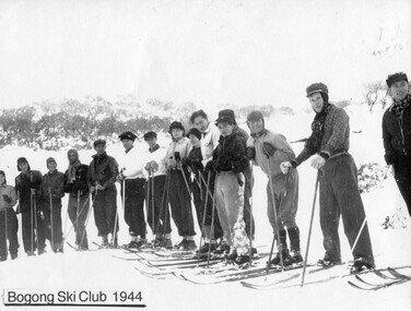
... Kiewa Valley Historical Society Mount Beauty Information Centre 31 Bogong High Plains Rd Mt Beauty high-country After World War II, the Kiewa Hydro-Electric Scheme was started in the Kiewa River Valley by the State Electricity Commission of Victoria. On land ...After World War II, the Kiewa Hydro-Electric Scheme was started in the Kiewa River Valley by the State Electricity Commission of Victoria. On land previously used only for summer cattle grazing in the natural alpine grasslands, the first ski lodge was built in 1948 by workers from the hydro scheme as skiing was a popular recreation. Many of the hydro employees were of European background and had grown up enjoying skiing and snow sports in their homelands and were keen to continue to pursue their winter sports interests. The first lift, a rope tow, was built in 1951 at Falls Creek and the first chairlift in Australia was constructed there in 1957. Two T-Bars were opened in 1961. In 1964, the Victorian Municipal Directory recorded that Falls Creek had 29 ski club lodges and 16 commercial lodges. The area became a popular tourist destination for both winter and summer sports.: Employees of the State Electricity Commission of Victoria in the Kiewa River Valley were the earliest skiers on the Bogong High Plains and built one of the first ski lodges at Falls Creek. They were amongst those pivotal in the development of the skiing and tourist industry at Falls Creek and on the Bogong High Plains. Collection of 10 copies and original black and white photographs and printed articles relating to skiing on the Bogong High Plains. Some pieces have been enlarged to A3 poster size copies for display purposes 1. Copy of black and white photograph of group of skiers at Falls Creek 2. Copy of photograph of early skier on Bogong High Plains with temporary buildings and tents in the background 3. Copy of photograph of 3 skiers on Mt McKay 4. Copy of SECV photograph of Rocky Valley Camp under snow 5. Early sepia photograph of Falls Creek village with skiers in the foreground 6. Copy of a page from booklet (SECV?) promoting the benefits of owning a holiday home in the Bogong Village area 7. Copy of a page from booklet (SECV?) promoting the benefits of holidaying in and around Falls Creek/Mt Beauty 8. Panoramic view of ski fields with skis in the foreground 9. Photograph of young skier (identity unknown) 10. Photograph of 2 male skiers (identity unknown) performing a small jump 1. Bogong Ski Club Members & Friends 1944 2. Jack Neve – electrician. Rocky Valley 3. 17.5.55 Skiers ascending Mt McKay 4. State Electricity Commission of Victoria. Date:17.8.55 No:K8132 Kiewa Hydro Electric Works. Rocky Valley Camp – From Engineering Office 5 & 9 No markings 6 & 7 Short article relating to photos on each page 8. Handwritten signature on rear of photo (Sandra Conea) 10 Faded unreadable photographers stamp and handwritten numbers 6875 on rear secv; bogong high plains; skiers; falls creek; tourism -
 Kiewa Valley Historical Society
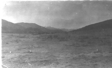
Photographs – Bogong High Plains - Set of 16 black and white photographs mounted back and front on 3 pieces of heavy black card likely removed from a photograph album
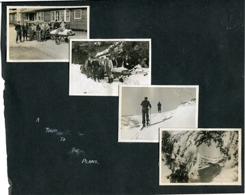
... Kiewa Valley Historical Society Mount Beauty Information Centre 31 Bogong High Plains Rd Mt Beauty high-country After World War II, the Kiewa Hydro-Electric Scheme was started in the Kiewa River Valley by the State Electricity Commission of Victoria. On land ...After World War II, the Kiewa Hydro-Electric Scheme was started in the Kiewa River Valley by the State Electricity Commission of Victoria. On land previously used only for summer cattle grazing in the natural alpine grasslands, the first ski lodge was built in 1948 by workers from the hydro scheme as skiing was a popular recreation. Many of the hydro employees were of European background and had grown up enjoying skiing and snow sports in their homelands and were keen to continue to pursue their winter sports interests. The first lift, a rope tow, was built at Falls Creek in 1951 and the first chairlift in Australia was constructed there in 1957. Two T-Bars were opened in 1961. In 1964, the Victorian Municipal Directory recorded that Falls Creek had 29 ski club lodges and 16 commercial lodges. The area became a popular tourist destination for both winter and summer sports.Employees of the State Electricity Commission of Victoria in the Kiewa River Valley were the earliest skiers on the Bogong High Plains and built one of the first ski lodges at Falls Creek. They were amongst those pivotal in the development of the skiing and tourist industry at Falls Creek and on the Bogong High Plains. Black and white photographs of varying sizes mounted decoratively on heavy black Card. Some pages display a brief description printed in white ink 1. 4 photographs- displayed diagonally across page. 2 pictures of a group of men standing in the snow in front of a car with a loaded trailer behind. 1 photo of skiers. 1 photo of show hanging in tree branches. 2. 2 photographs- showing Upper Kiewa Road with snow in the background 3. 3 photographs- of skiers and 1 photo of 2 of men posing in the snow & 1 photo of 2 men posing shirtless in warmer weather. 4. 2 photographs- arranged diagonally on page showing early buildings and construction at Bogong Village 5. 2 photographs- 1 showing view of Bogong Village from higher up the mountain. 1 showing early Bogong High Plains road 6. 1 photograph- showing view down along Kiewa Valley from higher up in the mountains 1. Handwritten in white ink – A TRIP TO THE PLAINS 2. Handwritten in white ink – UPPER KIEWA ROAD MT FAINTER IN BACKGROUND 3 – 6. No markings bogong village; upper kiewa road; bogong high plains; falls creek; skiers -
 Kiewa Valley Historical Society
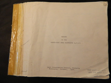
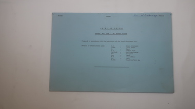
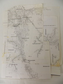
Report - Alpine Study Area Volume 2 Maps, Land Conservation Council, 1970s
... Kiewa Valley Historical Society Mount Beauty Information Centre 31 Bogong High Plains Rd Mt Beauty high-country The Victorian Environmental Assessment Council and the former Environment Conservation Council (ECC) and Land Conservation Council (LCC) have completed 36 land use investigations over more than 35 years, including 27 regional reviews. ...The Victorian Environmental Assessment Council and the former Environment Conservation Council (ECC) and Land Conservation Council (LCC) have completed 36 land use investigations over more than 35 years, including 27 regional reviews. They provide a framework for use of Public Land in Victoria. The Land Conservation Council was established by the Land Conservation Act 1970.These maps provide an assessment of the Alpine area at the time the maps were created. Some of the topics eg. Rainfall and water resources may change over the years thus providing a comparative analysis. Others may provide information for future development such as mineral exploration, building of a dam / tunnel etc.Blue box shaped folder containing 9 of 10 Maps of the Alpine Study Area produced by the Land Conservation Council. Maps include 1. Public land and descriptive blocks. 2. Physiography. 3. Topography. 4. Geology (missing). 5. Rainfall and water resources. 6. Vegetation 7. Land systems. 8. Recreation. 9. Primary production. 10. Minerals Ex library item. Stamped in red "Discarded From Stock / Swan Hill Regional Libraryalpine area, maps of alpine area, land conservation council -
 Kiewa Valley Historical Society
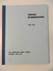
Report - Alpine Area Proposed Recommendations, Land Conservation Council, Victoria Melbourne, April 1978, April 1978
... Kiewa Valley Historical Society Mount Beauty Information Centre 31 Bogong High Plains Rd Mt Beauty high-country The Land Conservation Council was established by the Land Conservation Act 1970. ...The Land Conservation Council was established by the Land Conservation Act 1970. It makes recommendations to the Minister for Conservation with respect to the use of public land. Notices showing the boundary of the study area ... published in the Victorian Government Gazette Sept. 1973. A descriptive report was published in July 1977. Submissions (1538) on the future use of public land were received & included those representing a wide cross-section of the community. These were considered in the final report.Of interest for research on the changing ideas regarding the use of public land and the environment.Blue book bound by dark blue cloth tape. It has 92 pages with maps at the end and an empty folder inside the back cover.alpine area, land conservation council, alpine study area report -
 Kiewa Valley Historical Society
Papers - Jim Goonan's Story - Dederang, 1950's
... Mt Beauty high-country Early settlers came to Dederang from Kergunyah. The main road, Dederang to Tawonga was opened about 1860 - 1864, connecting 'Crosthwaite's Gap' with 'Smith's corner'. Jim Goonan's ancestors selected land ...Early settlers came to Dederang from Kergunyah. The main road, Dederang to Tawonga was opened about 1860 - 1864, connecting 'Crosthwaite's Gap' with 'Smith's corner'. Jim Goonan's ancestors selected land between Dederang and Tawonga in the early 1860's.A comprehensive history of the town of Dederang from the 1860's up to the 1950's. Early settlers, infrastructure, businesses, activities including sport and life style are described giving an insight into how the Kiewa Valley developed during this time.26 typed pages of the History of Dederang. Each page consists of paragraphs with a heading.dederang, jim goonan, kiewa valley -
 Kiewa Valley Historical Society
Report - Land Conservation Council x2, Land Conservation Council, Victoria Melbourne, April 1978, October 1974
... Kiewa Valley Historical Society Mount Beauty Information Centre 31 Bogong High Plains Rd Mt Beauty high-country Land Conservation Act 1970 established the Land Conservation Council to investigate and recommend to the Minister use of public land in Victoria. ...Land Conservation Act 1970 established the Land Conservation Council to investigate and recommend to the Minister use of public land in Victoria. It describes and assesses the natural resources:-Physiography, Geology, Topography, Land Systems, Outdoor Recreation, Public land and blocks. Primary Production. Vegetation.North East Victoria includes the Kiewa Valley. This report gives an understanding of the development of the area.Thick heavy book with 312 pages with black and white photos. Back half has a folder with heavy cardboard attached to thick cardboard back cover. Inside folder are 9 maps with color each with a different title.Stamped on Front Cover: "Mount Beauty High School" Has a library borrowing slip at the back of the last page.land conservation council, environment, public land, kiewa valley, planning -
 Kiewa Valley Historical Society
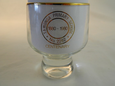
Trophies - Glass - Tawonga Primary School, 1980
... Mt Beauty high-country The Tawonga Primary School was a weatherboard building built on 8 acres. In 1900 a fire destroyed the building and its records. The school was then moved to the Old Tawonga Hall before a new one was built in 1910 on land donated by Frank Cooper. ...The Tawonga Primary School was a weatherboard building built on 8 acres. In 1900 a fire destroyed the building and its records. The school was then moved to the Old Tawonga Hall before a new one was built in 1910 on land donated by Frank Cooper. In 1937 and 1954 further buildings were added. Tobacco farming and the building of the Kiewa Hydro Electric Scheme increased the number of pupils during the 1950s and 1960s. This glass represents the celebration held when the school became 100 years old.Tawonga Primary School was established for the children of the farmers of the Kiewa Valley in 1880 and later for children of the tobacco farmers and workers on the Kiewa Hydro Electric Scheme. The history of the school reflects the activities of the people living in the valley and in particular Tawonga township.Clear glass with gold metal brim and embossed in gold on two sides. Base is solid tapering up to the glass sides.On one side: Gold embossed picture of school building On opposite side: Gold embossed 2 circles - Inside inner one: 1880 - 1980. Between this and outer circle - Tawonga Primary School No 2282. Underneath both circles gold embossed: Centenarytawonga primary school, kiewa valley, education -
 Kiewa Valley Historical Society
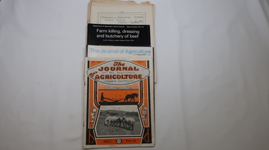
Journals - Department of Agriculture, 1. 1950s and 2. one 1932 & others 1970s
... It provided the township of Mt Beauty at the upper end of the valley where shops and schools were constructed, roads were improved out of the valley and the supply of electricity for milking etc. became available. farming, agriculture, cattle, pasture, kiewa valley, department of agriculture in victoria, kiewa hydro electric scheme, 1. "J.H.Wallace" hand written top right corner of covers of pamphlets titled 'Diseases Affecting /Young Cattle' and 'Mastitis'. "AHW" hand written top right corner of cover of pamphlet titled ' Grading Land ...The Kiewa Valley has been a farming district from early settlement of white people. This has continued until the present although the nature of farming has varied over the years. Access to information has improved with transport and technology. The journals kept the farmers informed and up to date.These booklets and journals were one of the few sources of information during the 1950s for the isolated farmers of the Kiewa Valley. The Kiewa Hydro Electric Scheme improved both transport and technology during the scheme's construction from the 1940s. It provided the township of Mt Beauty at the upper end of the valley where shops and schools were constructed, roads were improved out of the valley and the supply of electricity for milking etc. became available. 1. 14 articles each bounded by 2 staples, and each reprinted from Dept. of Agriculture Journal on a particular topic relating to Agriculture. All black & white and c1950s. 2. 4 Journals with colored covers 3 from Victoria Dept. of Agriculture (1932, 1974 & 1975) and 1 from Sth. Australia.1. "J.H.Wallace" hand written top right corner of covers of pamphlets titled 'Diseases Affecting /Young Cattle' and 'Mastitis'. "AHW" hand written top right corner of cover of pamphlet titled ' Grading Land for Irrigation' 2. Nonefarming, agriculture, cattle, pasture, kiewa valley, department of agriculture in victoria, kiewa hydro electric scheme, -
 Kiewa Valley Historical Society
Folder - Kiewa Methodist Church, 1917 to 1962
... Mt Beauty high-country The copy of a letter written by Harry H. Simmonds of Huon notes that "the church existed in 1905. It was built by Hill and McCormack with timber donated by Mr Ned Dunstan on ground donated by Mr James Thomas probably in the late 1800s. It was possibly called a Methodist Church because the donor of the land ...The copy of a letter written by Harry H. Simmonds of Huon notes that "the church existed in 1905. It was built by Hill and McCormack with timber donated by Mr Ned Dunstan on ground donated by Mr James Thomas probably in the late 1800s. It was possibly called a Methodist Church because the donor of the land was a Methodist. It was used by the three Protestant Groups and maintenance was paid for by an annual area collection.The house on the west side was a Presbyterian Manse for many years and the block of ground on the north side was known as the Manse paddock in which the minister grazed his cow and horse." In 1936 there was a fence between the Kiewa Methodist Church was the Presbyterian Church in Kiewa. Its Certificate of Title is Volume 5134 Folio 1026783 (Sept. 1942.) In 1952, the church was made of wood with an iron roof. In 1954. Request to Yackandandah Shire re a fence from Kiewa Consolidated School entrance to the unused hedge adjacent to the Church. In 1958 there was correspondence re 'the strip of land on each side of the Church.' Churches were an important part of life during the late 19th century and early to mid 20th century and were built in the centre of town as was this one. These papers give an understanding of the work involved in maintaining a church. The letters and 'book' give a lot of names of local families involved with the Methodist Church at Kiewa. Yellow plastic spiral folder with 18 pages enclosed in clear plastic sleeves.Papers enclosed include accounts, payments, tenders and other correspondence relating to the Methodist Church at Kiewa dating from 1932 to 1962. Of particular interest is a black cardboard cover book dated 1917 re collection of donations from listed people. The latest date in the book is 1942.Enclosed in first plastic sleeve is a letter from the donor, Kathie Vines dated 15th July 2013methodist church; kiewa; harry h. simmonds; yackandandah council; -
 Kiewa Valley Historical Society
Book - Mt Beauty Voters' Roll, Shire of Bright - Voters' Roll 1979 - Mt Beauty Riding, 1979
... Mt Beauty. Alex McCullough was a resident of Mt Beauty and Councillor in the Bright Shire. shire of bright; mt beauty riding; voters roll; parish of wermatong; alex mccullough On the cover, top right hand corner "Cr McCullough" 40 pages of firm blue paper with black typed print on one side only in 'landscape' format. Held by three staples. Each page has columns - numbered 1 to 656; Surnames in alphabetical order; Given names; Occupation; Includes L = 'land ...Electoral roles list people who are registered and eligible to vote at federal, state, territory and local government elections and referenda. Prior to 1990 the rolls list voters in alphabetical order by surname and first names within each Sub-division of an electoral Division of each State or Territory. The roll is useful and interesting for family historians and the study of demographics.Electoral rolls help to locate the residential address of a person in a particular year or over a period of years. They can be used as a substitute for census records for family historians and the history of a particular place, in this case Mt Beauty. Alex McCullough was a resident of Mt Beauty and Councillor in the Bright Shire. 40 pages of firm blue paper with black typed print on one side only in 'landscape' format. Held by three staples. Each page has columns - numbered 1 to 656; Surnames in alphabetical order; Given names; Occupation; Includes L = 'land'; Address followed by Lot number in the Parish of WermatongOn the cover, top right hand corner "Cr McCullough"shire of bright; mt beauty riding; voters roll; parish of wermatong; alex mccullough -
 Kiewa Valley Historical Society
Photograph - 30 black and white photographs (assorted sizes) plus page from a newspaper and copied article on A4 paper, c1880's c1910 - 1920 (photographs) Newspaper 1961
... Kiewa Valley Historical Society Mount Beauty Information Centre 31 Bogong High Plains Rd Mt Beauty high-country K2,3 and4 are of the Kiewa River and two of the bridges spanning the river along the valley. K3 and K4 would have been taken in the 1880's and show the type of trees and plant growth along the river prior to land clearing for farming. ...K2,3 and4 are of the Kiewa River and two of the bridges spanning the river along the valley. K3 and K4 would have been taken in the 1880's and show the type of trees and plant growth along the river prior to land clearing for farming. K5 is of the Running Creek Cricket Team and therefore there was sufficient population in the area to form and maintain a team as well as have other teams in the relatively near vicinity to provide competition. Note the horse drawn cart which provided transport. Date taken is unknown but possibly c 1910. The Mt. Buffalo Chalet was built in 1910 by the Victorian Government. It was Australia's first ski resort and has served generations of skiiers, hikers and families over the years. It was built for 3195 pounds and has had stories and wings added since and is the largest timber building in Australia. B4 is the earliest photo in this group as the garden is in early stages of development - the other photos show the growth of the shrubs and would be taken about c 1920. Note the cars and motor bikes. It closed in 2006. The other photos are of general interest only but interesting to see that there were donkey's grazing. There is no information as to their purpose on Mt. Buffalo. Four different Kiewa Valley families are represented in the photographs. Their descendants still live in the Valley and carry on the traditions of beef and dairy farming. Of particular interest is the photo of Miss Marjorie Clemence, the first School Teacher of Upper Gundowring School. Gundowring pastoral run was taken up in 1838 and occupied by framers in the 1860's. The area was known as Gundowring and Upper Gundowring. The Gundowring School was opened in 1871 and most likely the Upper Gundowring school would be built at the same time. It was School No. 2733 and situated in Boyd Road. It closed in 1953 when the Kiewa Consolidated School opened. The newspaper page describes the activities in which the local community of Kergunyah were in engaged in that period - Red Cross, Fire Brigade, cattle round up and some of the identities involved. The article photocopied from the Yackandandah times states that he (Norman Coad) "was sent to the Ovens District Hospital, Beechworth for treatment" which would mean that this was the closest hospital to the Kiewa Valley for emergencies in 1912.The Kiewa Valley photographs are of social significance showing two of the early bridges allowing the community easy access to both sides of the river and also the tree and plant growth before land clearing for farming. The photos of Mt. Buffalo Chalet have social, architectural and historical significance. the Chalet has been used by skiers, bush walkers and day trippers since its completion in 1910 and its closure in 2006. It is listed in the Victorian Heritage Register. The family photographs are of social and historical significance as they are of early farming families in the Kiewa Valley and also depict the dress, of both men and women) in the late 1880's. The write up in the Weekly Times has social significance as it depicts the social and farming activities and photos of the local residents from around that area. The article from the Yackandandah Times is of a personal nature with concern for the individual involved. Note: There is a photo of the gentleman mentioned in the article (Mr. Norman Coad) in the Families of the Kiewa Valley (F4) as above.30 black and white photographs - 5 of the Kiewa Valley, 8 of families of the Kiewa Vallley and 17 of Mt. Buffalo. Various sized photos. Page from the Weekly times and copied article from the Yackandandah Times on A4 sheet.(Note for easier identification they have been numbered and grouped - K1-5 (Kiewa Valley), F1-8 (Families) and B1-17 (Mt. Buffalo). K1: handwritten in ink, lower L hand corner "Bogong in the distance". K2: handwritten in ink lower L hand corner "Mongan's Bridge or Towonga". K3 handwritten in ink "Taken from Mongan Bridge looking up stream". K4 - no inscription. K5: handwritten in ink, back of photo "Running Creek Cricket Team". F1: handwritten in ink on back "Mrs. Heap" and lower down in pencil "1880's". F2 handwritten in pencil at top of back phot "Land at Tawonga TROVE The Y'dah Times 20/2/1913" and lower down in ink "Henry Ellis Larkin". F3: handwritten in ink bottom edge "Mrs Coad". Note that this photo is a postcard. F4: Written in ink lower edge "Norman Coad". Note this photo is also a postcard. F5: Lower left corner in Ink "Harry Larkin". F6: lower half back of photo, in ink "Bernie Maddison". F7: on back of photograph in ink "Miss Marjorie Clemence first School Teacher Upper Gundowring: and underneath, in pencil "C1880's". F8: Handwritten in ink on back of photo "Frank & Mrs. Keat & Lesley of Tawonga". Lower down in pencil "c1912-1914". B1: Back of photo in ink "The Chalet Mt. Buffalo". B2: no inscription. B3: "chalet at Bufflo" in ink lower left corner. B4: This is a post card. Written in ink is "Mt. Buffalo Chalet". B5 - B10 printed in ink, lower left corner "Buffalo". B11: no inscription. B12: "Mt. Buffalo" lower R corner. B13: "Buffalo?". B15: Printed in ink lower edge "Picnic at Buffalo". B16: "Donkeys on Mt. Buffalo" printed in ink lower edge. B17: handwritten in ink across back of photo "Donkeys & top of Mt. Buffalo with the Monileith in the distance". A4 sheet of paper describing an accident to Mr. Norman Coad. Under article is : Yackandandah Times (Vic: 1890 - 1931), Thursday 18 July 1912, page 3. A page torn from the Weekly Times, June 14, 1961 and entitled "Kergunyah has picturesque setting". kiewa valley, farming, families, kergunyah, gundowring upper, mt. buffalo chalet, briggs family, larki family, coad family, clemence family, laskowski collection -
 Kiewa Valley Historical Society
Maps of Victoria
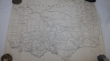
... Mt Beauty high-country maps of victoria 19th century oven and murray district of victoria Three maps: copies from the 19th century. 1. Handwritten 'Dept of Lands & Survey 1876'. 2. Map of the Ovens & Murray District, Victoria with handwritten 'F.H. Hiscock & Co's, New Victoria Countries Atlas 1874'. 3. Map of the Murray and Gipps Land ...Three maps: copies from the 19th century. 1. Handwritten 'Dept of Lands & Survey 1876'. 2. Map of the Ovens & Murray District, Victoria with handwritten 'F.H. Hiscock & Co's, New Victoria Countries Atlas 1874'. 3. Map of the Murray and Gipps Land Distr' with handwritten: "Baillieu's County Atlas of Victoria 1866'.maps of victoria, 19th century, oven and murray district of victoria -
 Kiewa Valley Historical Society
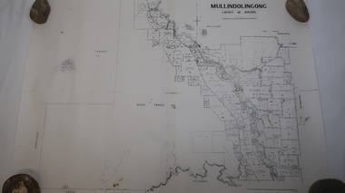
Map - Mullindolingong
... Kiewa Valley Historical Society Mount Beauty Information Centre 31 Bogong High Plains Rd Mt Beauty high-country Land owners of land in the Kiewa Valley in 1928 The Kiewa Valley was farming country with families settling in the area prior to 1928 mullindolingong kiewa valley land owners families of the kiewa valley Two sheets the same: (one old with paper joined together and the other is a copy without any joins. 21 6 1928 dated Map of Mullindolingong / County of Bogong showing land owners along the Kiewa River and beyond.Produced by the Department of Lands and Survey, Melbourne Map - Mullindolingong ...Land owners of land in the Kiewa Valley in 1928The Kiewa Valley was farming country with families settling in the area prior to 1928 Two sheets the same: (one old with paper joined together and the other is a copy without any joins. 21 6 1928 dated Map of Mullindolingong / County of Bogong showing land owners along the Kiewa River and beyond.Produced by the Department of Lands and Survey, Melbournemullindolingong, kiewa valley, land owners, families of the kiewa valley -
 Kiewa Valley Historical Society
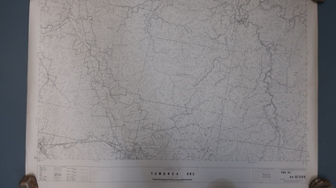
Maps - Tawonga and Feathertop
... Kiewa Valley Historical Society Mount Beauty Information Centre 31 Bogong High Plains Rd Mt Beauty high-country Plan of Tawonga showing roads etc, rivers, use of land in 1968 and of Feathertop in 1969. ...Plan of Tawonga showing roads etc, rivers, use of land in 1968 and of Feathertop in 1969.Historical use of land in Tawonga and Feathertop.1. Topographical Map - Tawonga 803 Forests Commission of Victoria 1968. Cream paper with black print. Legend: Roads, tracks etc, rivers, Parishes and use of land. 2. Feathertop 813. 1969tawonga map 1968, tawonga parishes, feathertop map 1969 -
 Kiewa Valley Historical Society
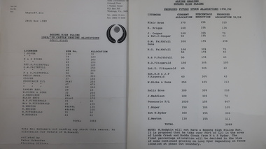
Papers - Cattle Grazing, Bogong High Plains
... Mt Beauty high-country Cattle grazing. In the 1990s government departments allocated the number of cattle being taken up to the Bogong High Plains by the families who traditionally leased land there. ...Cattle grazing. In the 1990s government departments allocated the number of cattle being taken up to the Bogong High Plains by the families who traditionally leased land there.Cattle grazing had been banned in other Alpine areas due to concerns of their impact on the environment. Kiewa Valley cattle graziers were caught up in the controversy as it was their tradition dating back to the 1840s. This controversy continues as cattle grazing was banned in 2005. 4 pages with black print: 1. 1989/90 Cattle Grazing Allocation and Dept. of Conservation Forests and Lands, Wodonga. 2. Proposed Future Stock Allocations 1991/92 list of 16 families 3. & 4. List of families, ear marks, brands etc. dated 22nd Feb. 1979 stapled togetherex S.C.A. / Benalla / Received 22nd Feb. 1979 / signedcattle grazing, kiewa valley farmers -
 Kiewa Valley Historical Society
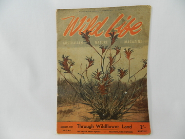
Magazine - Nature, Joseph Swanson Wilkinson, Wild Life Australian Nature Magazine, January 1949
... Mt Beauty high-country This magazine was part of the Bogong School's library and represents an important aspect of the school's curriculum. Bogong School was noted for having a great interest in nature and conservation. bogong primary school. bogong. wild life. nature. 'Registered at G.P.O. Melbourne for transmission by post as a periodical'. written in black in tiny print across the top. 1st line: 'Wild Life' in orange with white outline. 2nd line: 'Australian Nature Magazine' in white underneath title. All across top. 3rd written line: 'January, 1949 Through Wildflower Land ...This magazine was part of the Bogong School's library and represents an important aspect of the school's curriculum.Bogong School was noted for having a great interest in nature and conservation. 48 page soft covered magazine. Cover with limited colour including orange, black, white and brown with green. Inside pages in black, brown and grey pictures with black print on off white pages. Page 41 is in cartoon form. 'Registered at G.P.O. Melbourne for transmission by post as a periodical'. written in black in tiny print across the top. 1st line: 'Wild Life' in orange with white outline. 2nd line: 'Australian Nature Magazine' in white underneath title. All across top. 3rd written line: 'January, 1949 Through Wildflower Land 1/-' underneath picture of Kangaroo Paw. in black Underneath this writing follows: 4th line: 'Vol.11 No. 1 The Truth About Borers : : Beautiful Bird Pictures' in black Underneath 1/- is 'Monthly' Background behind black writing is orange same as title.bogong primary school. bogong. wild life. nature. -
 Kiewa Valley Historical Society
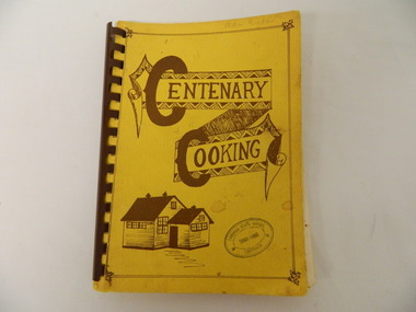
Book - Cooking x2, Centenary Cooking, 1980
... Kiewa Valley Historical Society Mount Beauty Information Centre 31 Bogong High Plains Rd Mt Beauty high-country The Tawonga School was a weatherboard building built on 8 acres of land catering for children from the surrounding grazing farms to ride their horses to school. ...The Tawonga School was a weatherboard building built on 8 acres of land catering for children from the surrounding grazing farms to ride their horses to school. It opened on 27th July 1880. The original school building and records were erased by fire in 1900. The Tawonga hall was used until 1910 when 3 acres of land was donated by Frank Cooper. It still operates today (2015) with its numbers having fluctuated over the years with the Kiewa Hydro Electric Scheme, tobacco farming and now tourism. The Tawonga community published a cook book to celebrate the school's centenary.This book may have also been used as a fund raiser.The Tawonga school celebrated its centenary with a cookbook with contributions from the community. This indicates that the school was very proud of reaching its centenary and the community co-operated with each other to develop this book.This book is a good source of the names of people who lived in Tawonga in 1980.Yellow book with brown writing and sketch of school held together with brown hard plastic binding. It has 90 pages of recipes most of which give the contributor's name.Tawonga State School Centenary 1880 - 1980 (stamped on front & back cover) In pencil on front cover: Ada Ryder An advertising for Kelvinator sticker has been stuck on the inside front cover with 18-3-92 written on it & on the inside back cover and 'Energy Rating' sticker.tawonga school. centenary of school. 1880-1980. cooking. food. kiewa valley -
 Kiewa Valley Historical Society
Parish Maps - Kiewa Valley
... Mt Beauty high-country The Parish Maps show how the Counties were divided into allotments for buyers. On one the original owners are named and the sizes of their properties given. The reference numbers enable individuals research the history of the property. The other is on a smaller scale giving only the allotment numbers. The map with the names gives information on the early settlers of the Kiewa Valley. They show how the Kiewa Valley was divided up into allotments for town dwellers and farmers and enables further research. kiewa valley. parish maps. land ...The Parish Maps show how the Counties were divided into allotments for buyers. On one the original owners are named and the sizes of their properties given. The reference numbers enable individuals research the history of the property. The other is on a smaller scale giving only the allotment numbers. The map with the names gives information on the early settlers of the Kiewa Valley. They show how the Kiewa Valley was divided up into allotments for town dwellers and farmers and enables further research.Two copies of Parish Maps of the towns in the Kiewa Valley. One gives the original owners and the other the reference numbers of the allotments.kiewa valley. parish maps. land owners -
 Kiewa Valley Historical Society
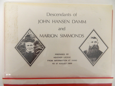
Folder - Family History, Descendants of John Hansen Damm and Marion Simmonds. Multiple copies, 1989
... Kiewa Valley Historical Society Mount Beauty Information Centre 31 Bogong High Plains Rd Mt Beauty high-country John and Marion Damm (nee Simmonds) selected 317 acres of land at Gundowring in 1873. ...John and Marion Damm (nee Simmonds) selected 317 acres of land at Gundowring in 1873. They lived there until 1902. Left for 4 years before returning to the Kiewa Valley in 1906.The Damm family is a pioneer family of the Kiewa Valley.Plastic red cover with transparent front held by 2 gold metal slide clips. 10 clear plastic sleeves holding a brief history, family tree, 4 typed pages, 5 handwritten pages, 4 typed pages - family of John Damm Jnr and handwritten pages - family of John Damm Jnr.damm family; simmonds family; kiewa valley; -
 Kiewa Valley Historical Society
Folder - Family History, The Maddison Family, 1968 and later
... George Maddison selected land in 1877 between the East and West Kiewa branches of the Kiewa River - known as the "Island". Now Mt Beauty...Kiewa Valley Historical Society Mount Beauty Information Centre 31 Bogong High Plains Rd Mt Beauty high-country George Maddison selected land in 1877 between the East and West Kiewa branches of the Kiewa River - known as the "Island". ...George Maddison selected land in 1877 between the East and West Kiewa branches of the Kiewa River - known as the "Island". Now Mt Beauty.Pioneer family in the Kiewa ValleyPlastic brown folder with transparent front held by 2 gold metal slide clips. 9 clear plastic sheets holding 4 typed sheets, 3 typed sheets by Ted Maddison 1968, 4 handwritten pages in 1 plastic sleeve and 6 handwritten pages in 1 plastic sleeve (the handwritten sheets are the same as the typed sheets.)maddison family; mount beauty; kiewa valley