Showing 185 items matching "water features"
-
 University of Melbourne, Burnley Campus Archives
Plan, Mark Burns, 3 Stage Therapy Garden Merve Irvine Nursing Home, 1996
... ...water features...University of Melbourne, Burnley Campus Archives 500 Yarra Boulevard Richmond melbourne mark burns merve irving nursing home landscape design therapy garden water features Laminated and coloured Planting Plan by Mark Burns dated 07.10.1996, File No B33 Sheet No 3 of 4. ...Laminated and coloured Planting Plan by Mark Burns dated 07.10.1996, File No B33 Sheet No 3 of 4. Scale 1:100.mark burns, merve irving nursing home, landscape design, therapy garden, water features -
 City of Kingston
Photograph - Black and white, c. 1944
... Houses, market garens, roads, and water features are all clearly visible....Houses, market garens, roads, and water features are all clearly visible. Photograph Black and white ...Aerial photograph of Moorabbin, including Chesterville Road, Keys Road and Wickham Road, Moorabbin, Briggs cottage, Neill's waterhole, McKittrick property, site of FRUMELBlack and white aerial view of Moorabbin. Houses, market garens, roads, and water features are all clearly visible.Handwritten in red ink on reverseL A 603 / 97% [in red circle] Handwritten in blue ink on reverse: 9502 06111 / M'bbinmoorabbin, city of moorabbin, chesterville, keys, wickham -
Tatura Irrigation & Wartime Camps Museum
Book, Finland 2006, 2006
... Pale blue cover, title in darker blue. Water features. Nanotech to the fore. What script for Europe. ...Contains loose leaf map finland tatura contemporary finland Pale blue cover, title in darker blue. Water features. Nanotech to the fore. What script for Europe. ...Gives an overview of Finnish competence in industry, business and technology. Contains loose leaf mapPale blue cover, title in darker blue. Water features. Nanotech to the fore. What script for Europe. Photography - exploring existencefinland, tatura, contemporary finland -
 Ringwood and District Historical Society
Document - Community Engagement Workshop, Eastern Gateway "Lake To Creek Link" Project - Ringwood, Victoria, 2007
... A key initiative of the Precinct Plan is the significant street upgrade which may include creative water features along Larissa Avenue to better connect recreational paths along Mullum Mullum Creek and Ringwood Lake....Ringwood and District Historical Society 125A Warrandyte Road Ringwood North melbourne A key initiative of the Precinct Plan is the significant street upgrade which may include creative water features along Larissa Avenue to better connect recreational paths along Mullum Mullum Creek and Ringwood Lake. 2-page Maroondah City Council notice for workshop on Tuesday 3 July 2007 at Urban Life, 143 Maroondah Highway, Ringwood - light refreshments served. ...2-page Maroondah City Council notice for workshop on Tuesday 3 July 2007 at Urban Life, 143 Maroondah Highway, Ringwood - light refreshments served.A key initiative of the Precinct Plan is the significant street upgrade which may include creative water features along Larissa Avenue to better connect recreational paths along Mullum Mullum Creek and Ringwood Lake. -
Tatura Irrigation & Wartime Camps Museum
Booklet, Shepparton, 1991
... Main picture on front cover Monash Park by night. Water features lit up, small orchard scene and boating on river. ...Main picture on front cover Monash Park by night. Water features lit up, small orchard scene and boating on river. ...Commissioned by City of Shepparton showing history of Shepparton in pictures, from early days, culture, industries, leisureNavy blue cover. Main picture on front cover Monash Park by night. Water features lit up, small orchard scene and boating on river. Back cover - fireworks at Lake Victoria.shepparton, goulburn valley, city of shepparton, history of shepparton -
 Wodonga & District Historical Society Inc
Drawing - Water Tower, Wodonga, 2020
... Water Tower...Scenic features Wodonga...Wodonga Water Tower Scenic features Wodonga Representation of the Water Tower in High Street, Wodonga in white frame Water Tower, Wodonga Drawing Water Tower, Wodonga ...THE WATER TOWER is a major landmark of High Street, Wodonga. It began operation from 1924 until it ceased operation in 1959. It stood unused for a decade until the lower section was modified and put to use as “ The Tower’s Cobbler’s Inn” in 1962. In 1972 Wodonga City Council proposed to demolish the Tower. Their suggestion received an unfavorable response from the city’s citizens, so the Tower still stands today.Donated by Dr. Imalka WettesingeRepresentation of the Water Tower in High Street, Wodonga in white framewodonga water tower, scenic features wodonga -
 Melbourne Tram Museum
Photograph - Set of 7 postcard size photographs - Wattle Park MMTB, Melbourne & Metropolitan Tramways Board (MMTB), 1960s
... Set of 7 photographs, probably by the MMTB of Wattle Park. 1 - Wattle Park Chalet building 2 - ditto - side view 3 - Children's playground area 4 - General view of the footpaths and park 5 - one of the water features 6 - View of some of the buildings. 7 - part of the golf course....Melbourne Tram Museum 8 Wallen Road Hawthorn melbourne Set of 7 photographs, probably by the MMTB of Wattle Park. 1 - Wattle Park Chalet building 2 - ditto - side view 3 - Children's playground area 4 - General view of the footpaths and park 5 - one of the water features 6 - View of some of the buildings. 7 - part of the golf course. ...Set of 7 photographs, probably by the MMTB of Wattle Park. 1 - Wattle Park Chalet building 2 - ditto - side view 3 - Children's playground area 4 - General view of the footpaths and park 5 - one of the water features 6 - View of some of the buildings. 7 - part of the golf course.Yields information about Wattle Park during the 1960s, which was owned and maintained by the MMTB.Set of 7 black and white photographs.tramways, mmtb, wattle park, golf -
 Glenelg Shire Council Cultural Collection
Painting, A S Murray, Dunrobin, n.d
... Depicted in shades of grey, the calm water features a patch of white in the centre - reflection. ...Depicted in shades of grey, the calm water features a patch of white in the centre - reflection. ...CEMA Art Collection Previously located in History HouseA large body of water with a shore line in the foreground on the left. Depicted in shades of grey, the calm water features a patch of white in the centre - reflection. In the background to the right, is a distant view of a small patch of land covered in trees. Behind the land is an out of focus view of mountains in the distance. The top half of the work features a grey cloudy sky. The work has a gilded ornate frame with cardboard and gold mounts and glass.Front: A.S. Murray Label attached to glass front: Presented to Council in 1984 by A.S. Murray Dunrobin Back: W. Hamer 189 Sturt Street Ballarat VICTORIA BUILDINGS, OPPOSITE CITY FIRE BRIGADElandscape -
 Federation University Historical Collection
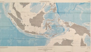
Map - Geological, U.S. Government Printing Office, Bathymetric Map of the Indonesian Region: Folio of the Indonesian Region Map I-875-A, 1974, 1974
... The area covered shows the islands and seas from Latitude 12 degree North to 16 degrees South and Longitude 90 degrees to 148 degrees. Various water features are also named....The area covered shows the islands and seas from Latitude 12 degree North to 16 degrees South and Longitude 90 degrees to 148 degrees. Various water features are also named. indonesia united nations economic commission department of state geological survey latitude longitude government of indonesia Longitude and Latitude are shown. ...Map was prepared on behalf of the Government of Indonesia, The United Nations Economic Commission for Asia and the Far East, the Agency for International Development and the U.S. Department of State in cooperation with the Geological Survey of Indonesia. The area covered shows the islands and seas from Latitude 12 degree North to 16 degrees South and Longitude 90 degrees to 148 degrees. Various water features are also named.Large map showing the Indonesian area - islands and seasLongitude and Latitude are shown. Major / Capitol cities indicated. Names of those responsible for the productionindonesia, united nations economic commission, department of state, geological survey, latitude, longitude, government of indonesia -
 Ambulance Victoria Museum
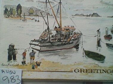
Card, Christmas, Ambulance Service Melbourne, Pre 1987
... Fold out Christmas card. Features water colour image of fishing boats tied up on beach...Ambulance Victoria Museum 1/55 Barry Street Bayswater melbourne christmas GREETINGS Fold out Christmas card. Features water colour image of fishing boats tied up on beach Card, Christmas, Ambulance Service Melbourne. ...Fold out Christmas card. Features water colour image of fishing boats tied up on beachGREETINGSchristmas -
 Glenelg Shire Council Cultural Collection
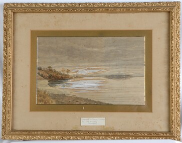
Painting, A.S. Murray, Scene on the River Murray, n.d
... Depicted in shades of blue and grey, the water features patches of brown and blue which illustrate the reflections of riverbank trees. ...Depicted in shades of blue and grey, the water features patches of brown and blue which illustrate the reflections of riverbank trees. ...Art collection Previously located in History HouseThe painting depicts a large body of water surrounded by tree-covered riverbank. Depicted in shades of blue and grey, the water features patches of brown and blue which illustrate the reflections of riverbank trees. In the foreground to the left of the water is a large tree which extends up to cover the top left skyline of the work. Featured in the background is a dense patch of trees completed in shades of blue. To the right of the water is a dense patch of trees completed in shades of brown and black. These trees reach into a purple and blue cloud-filled sky. The work has a gilded ornate frame with cardboard and gold mount and exposed canvas.Front: A.S. Murray Plaque attached to frame: SCENE on the RIVER MURRAY Back: (no inscriptions) -
 Glenelg Shire Council Cultural Collection
Print, View From A Boat, 1984
... In the foreground is the front of the boat and four birds about to take flight from the water. The background features a few boats and the buildings along Bentinck Street....In the foreground is the front of the boat and four birds about to take flight from the water. The background features a few boats and the buildings along Bentinck Street. ...Laminated screenprint of Portland harbour from the perspective of a boat looking back towards the shore. In the foreground is the front of the boat and four birds about to take flight from the water. The background features a few boats and the buildings along Bentinck Street. -
 Bendigo Historical Society Inc.
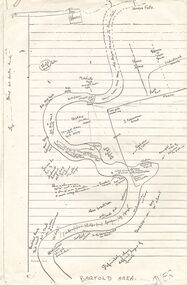
Document - PETER ELLIS COLLECTION: SKETCH OF THE BARFOLD GORGE
... On the sketch is the location of a house, trees, fences, different types of rock, some accessible areas to get down to the river, geological features and water falls....On the sketch is the location of a house, trees, fences, different types of rock, some accessible areas to get down to the river, geological features and water falls. Document PETER ELLIS COLLECTION: SKETCH OF THE BARFOLD GORGE ...Two photocopies of hand-drawn sketch of the Barfold Gorge. On the sketch is the location of a house, trees, fences, different types of rock, some accessible areas to get down to the river, geological features and water falls.place, land, barfold gorge, peter ellis collection, barfold area, mitchell's falls, queen's fall -
 Eltham District Historical Society Inc
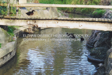
Photograph, Fay Bridge, Footbridge, Fort Knox Self Storage, 197 Sherbourne Road, Eltham, n.d
... The footbridge which extended from the facility to the landscaped garden and water features is now gone. The footbridge and garden were previously part of a former hat factory in Sherbourne Road Eltham which has in the past been used for various purposes and presently a self storage business. ...Eltham District Historical Society Inc 728 Main Rd Eltham melbourne The footbridge which extended from the facility to the landscaped garden and water features is now gone. The footbridge and garden were previously part of a former hat factory in Sherbourne Road Eltham which has in the past been used for various purposes and presently a self storage business. ...The footbridge which extended from the facility to the landscaped garden and water features is now gone. The footbridge and garden were previously part of a former hat factory in Sherbourne Road Eltham which has in the past been used for various purposes and presently a self storage business. The Karingal Yallock Creek passes through the front of the land and the creek environs are the subject of significant and unusual landscaping works, including some cascading water channels. Some of the landscaping was damaged by the Christmas Day floods of 2011, but the main elements remain intact. The landscaped area (as distinct from the factory itself) is the subject of a Heritage Overlay under the Nillumbik Planning Scheme. The basis of this overlay is a Heritage Report by Graeme Butler and Associates in 2006. As well as an assessment of the landscaped area, it includes one background information on the history of the site (although a complete history would require more research). The site was part of Crown Portion 3 of the Parish of Nillumbik that remained as the Montmorency Farm until early in the twentieth century. The 1911 subdivision of this farm created Lot 7 of some seven acres, which is the site of this factory. The Heritage Report lists the various owners of the site. From the rate records and aerial photos it is concluded that the site was used as an orchard and farmland until the 1940s. William F Crellin, orchardist, owned the site from 1912 to 1923. Then Edmund Williams owned it until 1951. In 1955 the site was owned by Rupert V. Kirsch and this is the name anecdotally associated with the hat factory, where the well-known brand of Fayrefield Hats were manufactured. There is some belief that this was built about the time of the Second World War and that hats for the armed forces were made there.fay bridge collection, eltham, fayrefield hat factory, foot bridge, sherbourne road, footbridge, fort knox eltham -
Bendigo Historical Society Inc.
Document - Fortuna Article - Handout Notes for a Tour, 1990s
... Bedrooms: Main bedrooms are located off a central passage, each with its own bathroom equipped with marble baths and cedar cabinetry.Pompeii Fountain: Constructed in 1879 as a scale replica of the Great Fountain in Pompeii, inspired by Lansell's travels.Includes statues, water features, and a Roman column with a statue, considered unique in Australia and possibly worldwide. ...Bedrooms: Main bedrooms are located off a central passage, each with its own bathroom equipped with marble baths and cedar cabinetry.Pompeii Fountain: Constructed in 1879 as a scale replica of the Great Fountain in Pompeii, inspired by Lansell's travels.Includes statues, water features, and a Roman column with a statue, considered unique in Australia and possibly worldwide. ...Here are the key points from the document on Fortuna Villa and its grounds: Music Room: Originally the main drawing room, featuring an ornate decorative ceiling and stained glass windows with musical inscriptions. The room was expanded in 1904, with earlier renovations enclosing an open colonnade in the 1890s. Conservatory: Built in 1876 after Lansell's European trip, showcasing high-quality etched glass and Italian design.Features rare glasswork, including Ruby Flashed Seedless French Antique glass and acid-etched panels with mining, Australian, and heraldic motifs. Reception Room: Served as the initial gathering space for guests, with a bay window added in 1875.Decorative elements like pressed metal ceilings, a cut glass skylight, and parquetry were likely added around 1895. Staircase: Made of cedar and blackwood, added in 1888 to access a new third floor, and remodeled in 1907. Features an upper balcony intersecting a large stained leadlight window. Bedrooms: Main bedrooms are located off a central passage, each with its own bathroom equipped with marble baths and cedar cabinetry.Pompeii Fountain: Constructed in 1879 as a scale replica of the Great Fountain in Pompeii, inspired by Lansell's travels.Includes statues, water features, and a Roman column with a statue, considered unique in Australia and possibly worldwide. Crushing Battery: A 30-head stamper battery built in 1874 for mining, attached to the villa's northern end.The chimney and machinery were removed in the 1940s, but the structure remains largely intact, now used as a printing press. These points highlight the architectural, artistic, and historical significance of Fortuna Villa and its associated features.Fortuna Article - Handout Notes for a Tour, by the Australian Government Department of defence support group This item contains the following document: 11217.61a A glossy coloured page A3 document of Fortuna lower floor and Ground Floor, which lists tha main points of the Villa and includes plans of the two floors.non-fictionbendigo, fortuna, george lansell, george victor lansell -
 Glenelg Shire Council Cultural Collection
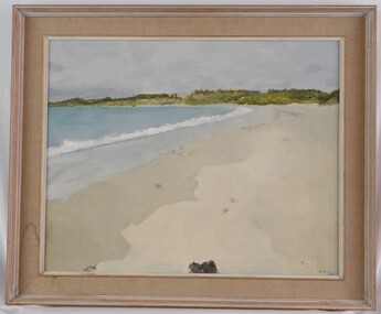
Painting, Irene Hill, Beach at Dutton Way, 1967
... To the right of the sand is the blue ocean with the white wash of a broken wave seperating the sand from the water. The background features foliage in various shades of green which meets a blue/purple sky. ...To the right of the sand is the blue ocean with the white wash of a broken wave seperating the sand from the water. The background features foliage in various shades of green which meets a blue/purple sky. ...CEMA Art CollectionThe painting depicts the shoreline of a beach with green foliage in the background. Various shades of sand make up the foreground, with a black object in the centre edge of the foreground. To the right of the sand is the blue ocean with the white wash of a broken wave seperating the sand from the water. The background features foliage in various shades of green which meets a blue/purple sky. The work has a painted white wooden frame with material mount and exposed canvas.Front: I.G. HILL 1967 (black painted, lower right corner) Back: White chalk:- ARTIST (underlined) MISS I.G.HILL 42 BOWEN ST. CAMBERWELL(underlined) Price $63 IRENE HILL "BEACH AT DUTTON WAY" (1967) (typed label) Yellow Sticker: 1967 -cema, portland artists society -
 Mont De Lancey
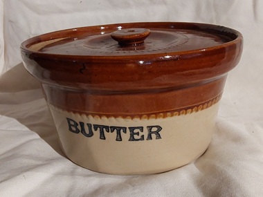
Functional object - Butter Dish, Unknown
... The porous nature of these materials, combined with design features like water-filled bases, created a cool, airtight environment that inhibited spoilage and allowed for easy use. ...The porous nature of these materials, combined with design features like water-filled bases, created a cool, airtight environment that inhibited spoilage and allowed for easy use. ...These containers were used in the home to store butter or later, margarine. Pottery, particularly ceramic and terracotta, were popular choices for butter containers before refrigeration was common because they helped keep butter fresh and spreadable at room temperature. The porous nature of these materials, combined with design features like water-filled bases, created a cool, airtight environment that inhibited spoilage and allowed for easy use. A two toned brown and cream round lidded pottery butter dish with a knob on the top of the lid. It has a glazed dark brown wide band at the top with a tiny pattern surround. The lower section is cream glazed ceramic. The brown lid is stamped with a small circular pattern.On the side of the dish, 'Butter' is printed in black lettering.butter containers, butter dishes, dishes, containers -
 South Gippsland Shire Council
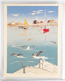
Print, Boats at Wicklow Harbour
... Set in cream card window mount. Features boats, water, buildings and low hills in the distance. ...Set in cream card window mount. Features boats, water, buildings and low hills in the distance. ...Colour print of a watercolour painting titled "Boats in Wicklow Harbour". Set in cream card window mount. Features boats, water, buildings and low hills in the distance. Colours of red, greys, creams, blues and browns. Title printed lower left corner and artists signature lower right corner. Produced by Wicklow Scenic Prints. Made in Ireland. -
 Bacchus Marsh & District Historical Society
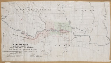
Map, General Plan for Water Supply Works, Shire of Bacchus Marsh 1887
... The plan includes the route of a proposed water channel in the Parwan area, and other features of water supply infrastructure such as the location of standpipes and gates are also shown on the plan....The plan includes the route of a proposed water channel in the Parwan area, and other features of water supply infrastructure such as the location of standpipes and gates are also shown on the plan. ...Debate about water supply and its planning and development took place in the Bacchus Marsh region from the 1850s through into the twentieth century. This plan was part of documentation to support an application for an additional loan of money from the Ministry of Water Supply to the Bacchus Marsh Shire Water Supply Trust. The plan includes the route of a proposed water channel in the Parwan area, and other features of water supply infrastructure such as the location of standpipes and gates are also shown on the plan.A single page paper map showing a general plan for the supply of water in the Bacchus Marsh area.The plan shows the route of the 'Main Channel' near the Werribee River and a proposed route for a Parwan Channel. The location of 'Dryden's House' near the Werribee River is also shown and the locations of land held by T. (Tom) Oliver and the Racecourse Reserve in Maddingley. Scale 40 chains to 1 inch. The plan is signed by Bacchus Marsh Shire Engineer, W.E. Standfield. The map is pasted into a bound volume containing 76 maps or plans in total. High resolution digital image stored on BMDHS computer network. General Plan of Water Supply Works in the Shire of Bacchus Marsh. Accompanying application for 2nd additional Loan. Original Waterworks district. Additional area. W.E. Standfield, 30/8/87.water supply, water supply maps, water supply bacchus marsh, irrigation, bacchus marsh victoria maps -
 Bendigo Historical Society Inc.
Document - BILL ASHMAN COLLECTION: CORRESPONDENCE
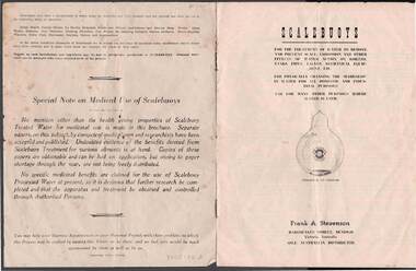
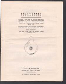
... Abbott, Jnr.)Also mentions How Scalebuoys Function, Not a 'Water-Softener', Special Features and First Cost is the Last Cost. ...Abbott, Jnr.)Also mentions How Scalebuoys Function, Not a 'Water-Softener', Special Features and First Cost is the Last Cost. ...Brochure titled Scalebuoys. Contains Scientific Treatise of Scalebuoy . . . Process of Water Treatment (By the Creator R. H. S. Abbott, Jnr.)Also mentions How Scalebuoys Function, Not a 'Water-Softener', Special Features and First Cost is the Last Cost. Scalebuoys Units includes Domestic Household Tank Unit, Hydraulic-Nozzle Tank Unit, Scalebuoy Tap Unit, Practical Applications of Scalebuoy for Domestic Uses, Scalebuoy Hand Unit, Vest Pocket Unit, Large Hydraulic-Nozzle Agitation Tank Unit, Motorized Tank Unit, A Few of the Many Industrial & Processing Applications, Motor Car Unit and a Special Note on Medical Use of Scalebuoys.sciences, instruments - general, scalebuoy, bill ashman collection - correspondence, frank a stevenson, r h s abbott jnr, bendigo electronic coy of australia, cambridge press -
 Bendigo Historical Society Inc.
Document - BILL ASHMAN COLLECTION: SCALEBUOYS BROCHURE
... Items mentioned are: Scientific Treatise of Scalebuoy - Process of Water Treatment, How Scalebuoys Function, Not a 'Water-Softener', Special Features, First Cost is the Last Cost. ...Items mentioned are: Scientific Treatise of Scalebuoy - Process of Water Treatment, How Scalebuoys Function, Not a 'Water-Softener', Special Features, First Cost is the Last Cost. ...Six copies of an eight page brochure titled 'Scalebuoys'. Printed by Cambridge Press, Bendigo. Items mentioned are: Scientific Treatise of Scalebuoy - Process of Water Treatment, How Scalebuoys Function, Not a 'Water-Softener', Special Features, First Cost is the Last Cost. Scalebuoy Units for Domestic Household Tanks, Hydraulic-Nozzle Tank Unit, Scalebuoy Tap Unit, Practical Applications of Scalebuoy for Domestic Uses, Scalebuoy Hand Unit, Vest Pocket Unit, Large Hydraulic-Nozzle Agitation Tank Unit, Motorised Tank Unit. Also A Few of the Many Industrial & Processing Applications, Motor Car Unit. On the back page is a list of where Scalebuoy Units have been installed.sciences, instruments - general, scalebuoy, bill ashman collection - correspondence, frank a stevenson, r h s abbott, jnr, bendigo electronic coy of australia, civic square bendigo, cambridge press -
 Warrnambool and District Historical Society Inc.
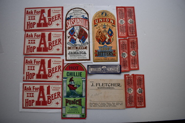
17 labels, J Fletcher, Early 20th century
... FLETCHER WARRNAMBOOL Approximately 26 Oz. .4 UNION TRADE MARK JOHN FLETCHER WARRNAMBOOL HOP BITTERS EXTRACTED FROM THE FLOWER .5 J FLETCHER WARRNAMBOOL SUPERIOR GREEN COLOURED WITH BURNT SUGAR GINGER CORDIAL .6 Identical to .3 .7,.8,.9,.10 ASK FOR XXX HOP A1 BEER J FLETCHER WARRNAMBOOL .11,.12,.13.14,.15.16 SODA WATER J Fletcher .17 LITHIA WATER J FLETCHER WARRNAMBOOL .1 Buff coloured rectangular card label with black text. 2 Rectangular label with curved top adhered to a piece of white paper. It is coloured red, blue black and gold and features ...In 1888 it was reported in "Victoria and its Metropolis" that John Fletcher carried on the business of a manufacturer of aerated waters, cordials, hop bitters, etc. in Warrnambool, and traded throughout the Western District. The establishment was started by a Mr. J. Davis with whom Mr. Fletcher was connected from its commencement, and whom he succeeded in 1885. His business continued until 1930. The Warrnambool and District Historical Society has a collection of bottles used by John Fletcher to contain his products. These labels are significant as John Fletcher was a most successful manufacturer of cordials and aerated waters in Warrnambool in the late 1800s and early 1900s .1 Buff coloured rectangular card label with black text. 2 Rectangular label with curved top adhered to a piece of white paper. It is coloured red, blue black and gold and features two standards and text. .3 Rectangular label with curved top adhered to the reverse of .2. It is coloured red and green and features a sketch of Punch carrying a bowl of a steaming substance and text .4 Rectangular label with curved top adhered to a piece of white paper. It is coloured red, apricot, dark and light blue, gold and black. It features the linked initials JF, two standards a trade mark and text .5 Rectangular label with curved top adhered to the reverse of .4 It is coloured red, blue, green, black and gold. It features two standards and text. .6 Identical to .3 but not adhered to paper .7,.8, .9 .10 White rectangular labels with red text. .9 has a damaged corner. .10 is adhered to a piece of white paper. .11,.12,.13,.14,.15..16 Red rectangular labels with black text and a coat of arms. .13 is adhered to a piece of pink card, .17 Blue rectangular label with text and a coat of arms .1 FROM J. FLETCHER, WARRNAMBOOL Manufacturer of Aerated Waters, Soda, Lithia and Tonic Waters, Lemonade, Ginger Ale, Hop beer, Hop Bitters, Sarsaparilla and all Cordials .2 SUPERIOR CONCENTATED COMPOUND EXTRACT OF SARSAPARILLA PREPARED FROM THE BEST RED ROOT OF JAMAICA SARSAPARILLA J. FLETCHER,WARRNAMBOOL .3 HOT CHILLIE PUNCH J. FLETCHER WARRNAMBOOL Approximately 26 Oz. .4 UNION TRADE MARK JOHN FLETCHER WARRNAMBOOL HOP BITTERS EXTRACTED FROM THE FLOWER .5 J FLETCHER WARRNAMBOOL SUPERIOR GREEN COLOURED WITH BURNT SUGAR GINGER CORDIAL .6 Identical to .3 .7,.8,.9,.10 ASK FOR XXX HOP A1 BEER J FLETCHER WARRNAMBOOL .11,.12,.13.14,.15.16 SODA WATER J Fletcher .17 LITHIA WATER J FLETCHER WARRNAMBOOL john fletcher, warnambool, cordials -
Warrnambool and District Historical Society Inc.
Medallion, Stokes Melbourne, Centenary of Victoria 1935, 1933
... Text The reverse features a hatted man wearing a suit and holding a walking stick standing on a grassy shore, a body of water and a sky line of buildings ...Text The reverse features a hatted man wearing a suit and holding a walking stick standing on a grassy shore, a body of water and a sky line of buildings Centenary of Victoria 1935 Medallion Stokes Melbourne ...This medal was given to Victorian school children to celebrate the centenary of European settlement in Victoria and the establishment of Melbourne in 1835. Portland was settled by the Henty brothers and John Batman and John Fawkner are the two names associated with the founding of Melbourne. The Melbourne Shrine of Remembrance was dedicated during these celebrations. This medal is a memento of the centenary of Victoria and may have been given a local Warrnambool school child. Circular silver coloured medal with ring at top and a further ring inserted. The obverse features a sailing ship entering a bay. Since "Portland " is part of the text it is assumed the bay is situated in Portland. Text The reverse features a hatted man wearing a suit and holding a walking stick standing on a grassy shore, a body of water and a sky line of buildings Obverse CENTENARY OF VICTORIA 1934 PORTLAND 1834 Reverse CENTENARY OF MELBOURNE 1935 1835 -
 Warrnambool and District Historical Society Inc.
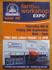
Pamphlet, Owens of Warrnambool
... There is information on the history of Owens of Warrnambool, Owens Water Industries, Owens Rural and Industrial Supplies and associated firms with their logos. There are black and white and colour photographs and the front page features the Owens logo and a photograph of the shop front in Caramut Road, Warrnambool...There is information on the history of Owens of Warrnambool, Owens Water Industries, Owens Rural and Industrial Supplies and associated firms with their logos. There are black and white and colour photographs and the front page features the Owens logo and a photograph of the shop front in Caramut Road, Warrnambool Owens of Warrnambool Pamphlet ...This is a brochure produced for the Owens of Warrnambool Farm and Workshop Expo. The story of Owens of Warrnambool began in the 1880s when Flett and Hopkins began a plumbing and blacksmith business in Lava Street. In the early 1900s the business was taken over by Bruce and McClure who added a foundry and produced and serviced farm equipment. In 1945 the business was purchased by four Owen brothers. In 1953 the business became known as Owens of Warrnambool. In 1987 the business was purchased by Alan Lane and following his death in 1995 the business became part of the Alan Lane Foundation. In 2000 the business was transferred to Caramut Road. This brochure is of some interest as it contains information on Owens of Warrnambool, a prominent business in Warrnambool today and one with a significant history in the city. This is an Owens of Warrnambool A4- size fold-out brochure of three pages, printed back to back. There is information on the history of Owens of Warrnambool, Owens Water Industries, Owens Rural and Industrial Supplies and associated firms with their logos. There are black and white and colour photographs and the front page features the Owens logo and a photograph of the shop front in Caramut Road, Warrnamboolowens of warrnambool, warrnambool -
 Bendigo Military Museum
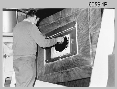
Photograph - Photographic Technicians performing tasks at the Army Survey Regiment, c1960s, c1970s
... water and dried leaving the exposed colour impression. The technician repeated this process using process or spot dyes for remaining publication colours. Type impressions were a combination of the map grid and the topographic features in their correct print colours, forming a base for the cartographer to accurately position map names and symbols on a clear film overlay. ...water and dried leaving the exposed colour impression. The technician repeated this process using process or spot dyes for remaining publication colours. Type impressions were a combination of the map grid and the topographic features in their correct print colours, forming a base for the cartographer to accurately position map names and symbols on a clear film overlay. ...These five photographs were most likely taken in the 1970s in Lithographic Squadron at the Army Survey Regiment, Fortuna, Bendigo. Photos .1P to .3P are annotated with the name of the technicians written on the back. Although Photo .4P is not annotated the technician is positively identified. In these five photos the technician is applying a UV-sensitive pigmented dye emulating one of the print colours to a white opaque polyester sheet mounted on a rotating table in a whirler. The coated sheet was dried before placement in a vacuum light frame beneath a stud registered map negative. They were then exposed to a carbon arc lamp. If there was more than one negative – typical for a type impression or 1st proof, the process was repeated for the other negatives of that print colour. There was a single exposure for composite negatives which was typical for the 2nd and final proof - the pre-press proof. The sheet was removed and washed with water and dried leaving the exposed colour impression. The technician repeated this process using process or spot dyes for remaining publication colours. Type impressions were a combination of the map grid and the topographic features in their correct print colours, forming a base for the cartographer to accurately position map names and symbols on a clear film overlay. The pre-press proof was a cost-effective way of producing a one-off visual copy of the map or chart product. It enabled cartographers to perform a quality inspection and correct any faults before publication. The pre-press proof was deemed authoritative before its release to Print Troop for bulk printing and distribution.This is a set of photographs of lithographic technicians preparing map proofs at the Army Survey Regiment, Bendigo c1960s c1970s. The photographs were printed on photographic paper and are part of the Army Survey Regiment’s Collection. The photographs were scanned at 300 dpi. .1) - Photo, black & white, c1970s, SGT Graham Jeffers, Lithographic Squadron .2) - Photo, black & white, c1970s, SGT Ken Slater Lithographic Squadron .3) - Photo, black & white, c1970s, Ian ‘Loft’ Turner, Lithographic Squadron .4) - Photo, black & white, c1970s, Gary Kerr, Lithographic Squadron .5) - Photo, black & white, c1960s, unidentified, Lithographic Squadron.1 to .3 – personnel names (less rank) annotated on back. .4 to .5P – no annotationroyal australian survey corps, rasvy, army survey regiment, army svy regt, fortuna, asr, litho -
 Kiewa Valley Historical Society
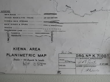
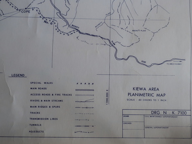
Map - Kiewa Area Planimetric Map
... Planimetric maps are two-dimensional representations of the Earth's surface, showing the location and spatial arrangement of features such as roads, buildings, and bodies of water....Kiewa Valley Historical Society Mount Beauty Information Centre 31 Bogong High Plains Rd Mt Beauty high-country Planimetric maps are two-dimensional representations of the Earth's surface, showing the location and spatial arrangement of features such as roads, buildings, and bodies of water. A very clear map showing the Kiewa Hydro Electric Scheme in two dimensions to include the construction done by the SECV. ...Planimetric maps are two-dimensional representations of the Earth's surface, showing the location and spatial arrangement of features such as roads, buildings, and bodies of water.A very clear map showing the Kiewa Hydro Electric Scheme in two dimensions to include the construction done by the SECV.Black and white Map of the Kiewa Area from Mt Beauty to the High Plains covering the Kiewa Hydro Electric Scheme and surrounds. Drawn on 11th May 1966kiewa hydro electric scheme 1966 -
 Kiewa Valley Historical Society
Maps - Kiewa Valley Parish Maps x3 and Kiewa Area Planimetric Map x1
... Planimetric maps are 2 dimensional representations of the Earth's surface, showing the location and spatial arrangement of features such as roads, buildings, and bodies of water. The parish maps show the occupiers with leases or licences of the land. ...Kiewa Valley Historical Society Mount Beauty Information Centre 31 Bogong High Plains Rd Mt Beauty high-country Planimetric maps are 2 dimensional representations of the Earth's surface, showing the location and spatial arrangement of features such as roads, buildings, and bodies of water. The parish maps show the occupiers with leases or licences of the land. ...Planimetric maps are 2 dimensional representations of the Earth's surface, showing the location and spatial arrangement of features such as roads, buildings, and bodies of water. The parish maps show the occupiers with leases or licences of the land. These are updated by the Department of Lands regularly. The names of early settlers of the Kiewa Valley occupying land by lease or licence are shown. Many of these familie's descendants still live in the Kiewa Valley.1. Kiewa Area Planimetric Map (photo) 2. Wermatong, County of Bogong Parish Map 3. Mulllindolingong, County of Bogong Parish Map 4. Mullagong, County of Bogong Parish Map All black and white kiewa valley. parish maps. land owners -
 Kiewa Valley Historical Society
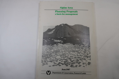
Book - Book - Alpine Area - Department of Conservation, Forests & Lands, Alpine Area / Planning Proposals / a basis for management. 1987
... features, values and uses. Planning is proceeding on this basis. Victoria's alpine area is one of the State's most outstanding and spectacular natural areas. It is noted for its diverse plant and animal life, scenery, recreation opportunities and as a water catchment. ...It is the policy of the Government that most of the State's alpine area will be proclaimed as an Alpine National Park, which would complement the Kosciusko National Park in N.S.W.. This is yet to be achieved (1987), however there is a need for sound, efficient and coordinated management based on the area's natural features, values and uses. Planning is proceeding on this basis.Victoria's alpine area is one of the State's most outstanding and spectacular natural areas. It is noted for its diverse plant and animal life, scenery, recreation opportunities and as a water catchment. This country is at the upper end of the Kiewa Valley and the planning for it is of interest to the Kiewa Valley inhabitants.White bound book with green print for title at the top, black & white picture and black print at the bottom for the name of the government authority publishing the book.143 pages with fold out map after page 7. The map is coloured green to indicate the planning area.alpine area, bogong national park, victorian department of conservation forests & lands -
 Ballarat Clarendon College
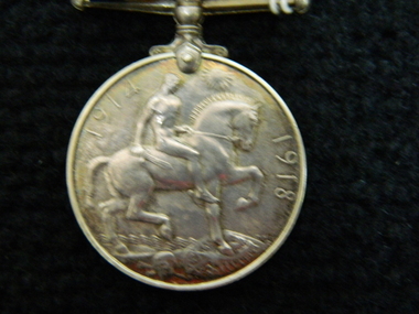
Medal, British War Medal, 1918
... features the effigy of George V on the obverse. The reverse has an image of St George on horseback trampling underfoot the eagle shield of the Central Powers, and a skull and cross-bones, the emblems of death. Above this is the risen sun of victory. The British War Medal has a wide central watered...features the effigy of George V on the obverse. The reverse has an image of St George on horseback trampling underfoot the eagle shield of the Central Powers, and a skull and cross-bones, the emblems of death. Above this is the risen sun of victory. The British War Medal has a wide central watered ...The British War Medal 1914-20 was iInstituted by King George V in 1919 to mark the end of World War I and record the service given. The qualification period was later extended to cover post-war mine clearance and service in Russia during 1919 and 1920. The British War Medal was awarded for service in a theatre of war between 5 August 1914 and 11 November 1918. Those eligible included members of women's organisations; persons on the staffs of military hospitals and members of recognised organisations who handled sick and wounded; and members of other duly recognised or other authorised organisations as specified in medal regulations. The qualification period was later extended to cover post-war mine clearance and service in Russia during 1919 and 1920. Lieut E. S. Holgate was mentioned in despatches for Gallantry in the Field 24/25 April 1918. He was killed in action at Villers-Bretonneux, 27 April, 1918. The British War Medal completes a trio of medals awarded to Lieut. E. S. Holgate, including the 1914-15 Star and the Victory Medal. The Holgate medals were the first war medals held by BCC archives. They have historical and social significance for the College.The British War Medal is round and made of cupro-nickel. It features the effigy of George V on the obverse. The reverse has an image of St George on horseback trampling underfoot the eagle shield of the Central Powers, and a skull and cross-bones, the emblems of death. Above this is the risen sun of victory. The British War Medal has a wide central watered stripe of orange, flanked by two narrow white stripes, which are in turn flanked by two black pin-stripes, further flanked by two outer stripes of purple. The colours have no particular significance. Impressed around edge are the recipient's details. Inscribed around outer edge of obverse: 'GEORGEIVS V BRITT. OMN:REX ET IND:IMP:' Impressed around edge of medal: 'LIEUT.E.S.HOLGATE. A.I.F.' Inscribed on the reverse '1914 1918'medal, 1918, world war 1, british war medal, w w 1, holgate, a i f, australian imperial force, holgate e s, holgate medal -
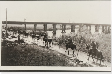 Lara RSL Sub Branch
Photograph, Set 4 photographs. and others for Torquay Light Horse camp, 1940
... water. They also showed remarkable ability to find their way in a strange country and use its features for cover, in both attack and defence. ...water. They also showed remarkable ability to find their way in a strange country and use its features for cover, in both attack and defence. ...These images capture for all time Light Horsemen travelling through Geelong on their way to camp at Torquay for the last Group meeting in Australia . information following - details obtained from .........https://torquayhistory.com/light-horse-brigade/ On Australia Day, 1997, Sir John Young unveiled this plaque on Point Danger, Torquay. Torquay history, Light Horse Training Camp, WW2 Plaque at Pt. Danger Note----- (See images to view plaque) The plaque identifies a significant event in Torquay’s history and the sentiments of ‘change’ for the Light Horse Brigade – from horses to machines. In 1940 the four Light Horse Regiments (4th, 8th, 13th and 20th), some 5000 Light Horse and 2000 horses camped and trained at Torquay. Three other regiments, formerly mounted on horses, were also at Torquay ‘mounted’ on privately owned trucks and cars. Division troops included Artillery, Engineers, Signals, Field Ambulance and other branches of the Army necessary to enable a Division to function. It wasn’t just the sheer numbers of men coming to this little town that made the event significant, it was also the fact that the men of the Light Horse were dramatic, almost glamorous figures and it is easy to see their exploits as some splendid adventure. Horses have played a special role in the story of Australia. They were the only means of transport across this huge country, so it was necessary for everyone to have the ability to ride a horse. When war broke out in 1899 between Britain and the Boers of South Africa (“Boer” was Dutch for “farmer”) Australia sent troops to fight. At first Britain was wary of using untried, unprofessional colonial cavalrymen but soon saw that the slouch-hatted Australian “bushmen” were a match for the fast-moving and unconventional mounted commandos of the Boers. The Australians proved themselves to be expert rough-riding horsemen and good shots. Bush life had hardened them to go for long periods with little food and water. They also showed remarkable ability to find their way in a strange country and use its features for cover, in both attack and defence. By 1914, when Australia joined the war against Germany, there were 23 Light Horse regiments of militia volunteers. Many men from these units joined the Light Horse regiments of the Australian Imperial Force (AIF). Men were given remounts (if not using their own horses) – army horses bought by Commonwealth purchasing officers from graziers and breeders. These were called “walers” because they were a New South Wales stockhorse type – strong, great-hearted animals with the strains of the thoroughbred and semi-draught to give them speed, strength and stamina. On 1st November, 1914, Australia’s First Infantry Division and the first four Light Horse regiments sailed for England in a fleet of transport ships. The first of the Light Horse arrived at Gallipoli in May without their horses. Back with their horses after Gallipoli, they were formidable combatants across the Sinai and Palestine. Some British commanders observed that the light horseman moved with a “lazy, slouching gait, like that of a sleepy tiger” but described how the promise of battle “changes that careless gait, into a live athletic swing that takes him over the ground much quicker than other troops”. They had Light Horse, Torquay, training campdeveloped a reputation as formidable infantrymen. The Turks called them “the White Ghurkas” – a reference to their deadly skill with the bayonet. The Arabs called them “The Kings of the Feathers”. The plume had originally been a battle honour of the Queensland Mounted Infantry for their work in the shearer’s strike of 1891. During WW1 it was adopted by almost all the Light Horse Regiments. It was the proud badge of the light horseman. The most famous of their battles was the attack on Beersheba- the charge of the 4th Light Horse Brigade. Mounted infantrymen and their superb walers had carried out one of the most successful cavalry charges in history – against what seemed impossible odds. They surprised the Turks by charging cavalry-style, when they would normally have ridden close to an objective then dismounted to fight. The fall of Beersheba swung the battle tide against the Turks in Palestine; and changed the history of the Middle East. While 19 men from the Surf Coast Shire served with the 4th Light Horse over the course of WW1, only four were involved in the charge of Beersheba- John GAYLARD, Philip QUINN.(Winchelsea); Wallace FINDLAY (Anglesea); Harry TRIGG (Bambra). After the war, Light Horse units played a key role in the Australian Government’s compulsory military training programme. The Citizen Military Forces (C.M.F.) thrived on the glamour of the wartime Light Horse tradition, ignoring the possibility that motor vehicles would soon replace the horses. When training was no longer compulsory, the C.M.F. regiments declined and horses became more of a luxury during the 1930s depression years of poverty and unemployment. Some regiments were motorised. Then, in 1939, Australia joined Britain in another world war. Training was increased for the militia at both home bases and regional training camps. The camp at Torquay in 1940, commanded by Major General Rankin, was at Divisional strength. By the end of the camp some felt that the Division was ready for active service. Gradually, over the next four years, the Australian Light Horse units were mounted on wheels and tracks and the horses were retired. Six men enlisted at the Torquay camp and another 57 men and women enlisted at Torquay for service in WW2. Those who served in the Militia provided valuable Officers and NCOs and men for the armed services during the war. Each infantry division of the 2nd AIF had a Light Horse regiment attached to it. But the day of the Australian mounted soldier hadn’t quite passed. During World War II, Australia’s 6th Cavalry Regiment formed a mounted unit they called “The Kelly Gang” which did valuable scouting work. In New Guinea, a mounted Light Horse Troop did patrol duty and helped carry supplies. Some fully equipped walers were flown into Borneo for reconnaissance in rugged mountain country. But by the end of the war, in 1945, the horse had disappeared from the Australian Army. References: Australian Light Horse Association www.lighthorse.org.au National Australia Archives Australian War Memorial Surf Coast Shire WW1 memorials www.togethertheyserved.com The Light horse- a Cavalry under Canvas Light Horse, Training Camp, Torquay, WW2 Late in 1939 it was decided to set up a Lighthorse training camp in Torquay to train both men and horses for the battles of the Second World War. Horses, men and equipment came on special trains from all over Victoria and NSW, and as you would expect horseman came from areas such as Omeo and Sale, the Wimmera and the Western District. They arrived at the Geelong racecourse for watering in the Barwon River and then were ridden across the ford at the breakwater and began their 11 mile trek to Torquay. Light Horse, Training Camp, Torquay, WW2 Tent city By the end of January 1940 the camp at Torquay accommodated some 5000 men and 2500 horses of the Second Cavalry Division. The rows of horses, tents and huts near Blackgate Road were quite a sight. While the cavalrymen engaged in exercises on the land and on the beaches, many of the troops took over the Torquay School for special training of men and officers. Mr Bob Pettit local farmer and Councillor for the Barrabool Shire, wrote about the Light horse in the Surf Coast Community News in 1985 saying “They used to travel about the district riding four abreast in one long convoy. To my annoyance they went through my property and shut all the gates behind them. I had certain gates open to let stock in to the water holes and it would take me three -quarters of an hour to follow the horsemen up and put all the gates right again” he continued “the men from the Light Horse were here when the fire went through in March 1940. He recalled an incident when early one morning, as some one blew the bugle, a soldier putting a white sheet on the line frightened the horses. They panicked and ran off in all directions. Six went over the cliff near Bird Rock, five were never found, and the rest were gathered up after nearly a fortnight in the bush around Addiscott and Anglesea" Light Horse, Training Camp, Torquay, WW2, Geelong Parade Geelong parade The training camp culminated in a parade through the streets of Geelong on March 12th 1940. The salute was given at the Town Hall and the troops continued on a route to the You Yang’s for a training exercise. Note-----(see media section for photograph) The Camp was abandoned in mid 1940 as it was deemed unsuitable for training during winter and the cost of a permanent camp could not be justified if it could not be used all year. Historic.......Rare,,,Interpretive.Sepia photographs.set of four ....post card size ....Horses &LighthorsemenNo 1, Lighthorsemen Regiment Geelong 1940......No 2 Light Horse at Breakwater Geelong 1938 to 1940....No 3 Light Horse at Breakwater Geelong 1938 to 1940.....No 4 Light Horse crossing Breakwater camped at Geelong Showgrounds. These markings are on reverse of photographs.light horsemengeelong 1940., world war 2