Showing 78 items matching "western district maps"
-
 Warrnambool and District Historical Society Inc.
Map (series) - Local Parish Maps, Local Government maps 1942 and three fire maps
... western district maps...These maps are a valuable resource for researchers looking at ownership of particular parcels on land. western district maps Belfast Brucknell Caramut Cooramook Framlingham East Framlingham West Garvoc Laang Kangertong Meerai Minjah North Minjah Minhamite Nullawarre Narrawaturk Nirranda Paaratte Panmure Purnim Quamby North Tallangatta Quamby Timboon Wangoom Willatook Woolsthorpe Yangery Yarpturk Ecklin Yeth- Youang. ...These show the Western District in detail with property owners named . The fire maps have properties which are numbered.western district maps, belfast, brucknell, caramut, cooramook, framlingham east, framlingham west, garvoc, laang, kangertong, meerai, minjah north, minjah, minhamite, nullawarre, narrawaturk, nirranda, paaratte, panmure, purnim, quamby north, tallangatta, quamby, timboon, wangoom, willatook, woolsthorpe, yangery, yarpturk, ecklin, yeth- youang.western district maps, belfast, brucknell, caramut, cooramook, framlingham east, framlingham west, garvoc, laang, kangertong, meerai, minjah north, minjah, minhamite, nullawarre, narrawaturk, nirranda, paaratte, panmure, purnim, quamby north, tallangatta, quamby, timboon, wangoom, willatook, woolsthorpe, yangery, yarpturk, ecklin, yeth- youang. -
 Warrnambool and District Historical Society Inc.
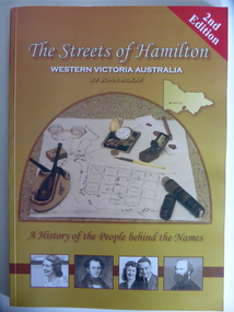
Book, Streets of Hamilton, 2007 (revised and reprinted 2009)
... Western District. The book will be a useful research tool. Hamilton, Victoria John McKay Street Names of Hamilton Warrnambool Front Cover: ‘2nd Edition’ ‘The Streets of Hamilton’ ‘Western Victoria Australia’ ‘By John McKay’ ‘A History of the People behind the Names’ This is a soft cover book of 174 pages. The back cover has a white background with black and white photographs of five local Hamilton people. The front cover has a yellow and brown background with black and white photographs of five local Hamilton people, an outline of a map ...This is a book providing information on the streets of Hamilton, Victoria and the origin of the names. Hamilton is a city in Western Victoria at the intersection of the Glenelg Highway and the Henty Highway. European settlement began with the arrival of pastoralists following the 1836 explorations of Major Thomas Mitchell. The Wedge family in 1839 had the property ‘The Grange’ which covered the site of Hamilton today. The town was gazetted in 1851 and named after a place in Scotland. Hamilton Victoria is the centre of a sheep-grazing and agricultural district. The book won an award in the 2008 Victorian Community History Awards. This book is of interest as it gives information on the Hamilton streets and the origin of their names. The history of Hamilton is of particular interest to those also living in the Western District. The book will be a useful research tool. This is a soft cover book of 174 pages. The back cover has a white background with black and white photographs of five local Hamilton people. The front cover has a yellow and brown background with black and white photographs of five local Hamilton people, an outline of a map of Victoria and a photograph of a map of the Hamilton area with some artefacts placed on the map. The book contains an Introduction, a Preface, a Foreword, an Early Days Overview, a list of Contents, a list of the streets in alphabetical order with information on the origin of the names, two Appendices and an Index. The book has many black and white photographs and sketches. Front Cover: ‘2nd Edition’ ‘The Streets of Hamilton’ ‘Western Victoria Australia’ ‘By John McKay’ ‘A History of the People behind the Names’hamilton, victoria, john mckay, street names of hamilton, warrnambool -
 Warrnambool and District Historical Society Inc.
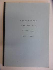
Booklet, Warrnambool City & Shire A Bibliography 1847-1988, 1989
... The publications may still be available at the Warrnambool Library or at the South West College of TAFE in Timor Street Warrnambool or at Deakin University in Warrnambool. history of warrnambool history of western district warrnambool library Front Cover: ‘Warrnambool City and Shire’ ‘A Bibliography 1847-1988’ This is a soft cover booklet of 162 pages. It has a pale blue cover and is bound with black tape. It has a map ...This 1989 booklet contains lists of publications connected with Warrnambool and District and it was compiled by W. Pinson and M. Johnstone. The publications listed were ones held at the time by the Warrnambool branch of the Corangamite Regional Library Service and the Warrnambool Institute of Advanced Education library. The publications are listed under the headings of Community, Environment, Heritage, Industry and Tourism. Although the information in this book is well out-of-date, it may be of interest to researchers today. The publications may still be available at the Warrnambool Library or at the South West College of TAFE in Timor Street Warrnambool or at Deakin University in Warrnambool. This is a soft cover booklet of 162 pages. It has a pale blue cover and is bound with black tape. It has a map of Warrnambool city, an Introduction, an alphabetical listing of publications concerning Warrnambool City and Shire and an Index. It has some photocopied black and white photographs of Warrnambool (untitled) and a reproduction of the front cover of Osburne’s History of Warrnambool.Front Cover: ‘Warrnambool City and Shire’ ‘A Bibliography 1847-1988’ history of warrnambool, history of western district, warrnambool library -
 Warrnambool and District Historical Society Inc.
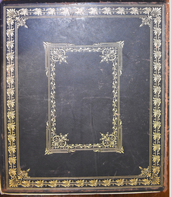
Book - Antiquarian book, Hon. Andrew Garran, Picturesque Atlas of Australasia Volume One, 1886
... Warrnambool History Western District History Australian History Australasian History picturesque atlas of australasia picturesque atlas of australasia volume 1 Contemporary and geographical record of Australasia in the 19th century This is a leather covered book. The cover is decorated with gold panels of fruit and gold lettering on the spine and has a plastic cover to protect it. There is gilt edging on the 388 pages. It contains text, sketches, lithographs and some coloured maps ...Contemporary and geographical record of Australasia in the 19th centuryThis is a leather covered book. The cover is decorated with gold panels of fruit and gold lettering on the spine and has a plastic cover to protect it. There is gilt edging on the 388 pages. It contains text, sketches, lithographs and some coloured maps and engravings on wood..non-fictionContemporary and geographical record of Australasia in the 19th centurywarrnambool history, western district history, australian history, australasian history, picturesque atlas of australasia, picturesque atlas of australasia volume 1 -
 Warrnambool and District Historical Society Inc.
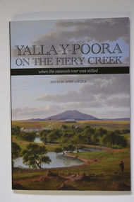
Book - Yalla-Y-Poora On The Fiery Creek, James Affleck, Yalla-Y-Poora On The Fiery Creek when the cannon's roar was stilled, 2023
... district including information and photographs of each of the 24 settler's and their families. This book is of considerable importance as it is a comprehensive record of the history of the post World War Two Soldier Settlement in the Yalla-y-Poora area. It will be very useful for local researchers. soldier settlement yalla-y-poora Number Six in James Affleck's series of book on Soldier Settlements in Western Victoria. An edited compilation of settler families' own stories, combined with a reincorporation of a previously published history of the area, profiles of local people and organisations illustrated with maps ...Number Six in James Affleck's series of book on Soldier Settlements in Western Victoria. An edited compilation of settler families' own stories, combined with a reincorporation of a previously published history of the area, profiles of local people and organisations illustrated with maps, photographs and poetry136 page softcover book. Front cover has the Title: "Yalla-Y-Poora On The Fiery Creek when the cannon's roar was stilled" printed over a coloured print of Eugene von Guerard's painting of Yalla-y-Poora; Back cover: Three colour photographs soldier settlement farming family descendants, soldier settler house and tractor. Yalla-Y-Poora On The Fiery Creek printed on spine.non-fictionNumber Six in James Affleck's series of book on Soldier Settlements in Western Victoria. An edited compilation of settler families' own stories, combined with a reincorporation of a previously published history of the area, profiles of local people and organisations illustrated with maps, photographs and poetrysoldier settlement, yalla-y-poora -
Warrnambool and District Historical Society Inc.
Document - Documents (3) of Farnham Cheese and Butter factory, 1890s (originals)
... These documents are of interest as the Farnham Cheese and Butter Factory was one of the earliest of its type in the Western District and won a Gold Medal in 1909 for butter-making at the Islington Dairy Show in competition with other butter-making countries in the world. Farnham Cheese and Butter Factory Nestles Factory Warrnambool .1 sheet of paper with black and white map showing location of factory in Dennington (copy) .2 An A3 size piece of paper with a sketch map and typed material showing a Certificate of Title (copy) .3 An 3 size piece of paper with a sketch map and typed material showing a Certificate of Title (copy) Document Documents (3) of Farnham Cheese and Butter factory ...These three sheets are copies of the originals and relate to the establishment of the Farnham Cheese and Butter Factory in Dennington (Warrnambool). The name 'Farnham' is the name of the Special Survey in the area first purchased by William Rutledge and also the name of the Rutledge property at Dennington. In 1889 WIlliam Rutledge (Junior) and Thomas Palmer established the Farnham Cheese and Butter Factory on the banks of the Merri River at Dennington. In 1890 they sold the factory to a farmers' co-operative. Farnham had a high reputationfor butter=making when the factory was in existence. The factory was bought out by Nestles about 1909 with that company establishing its factory on the same area.in 1911. These documents are of interest as the Farnham Cheese and Butter Factory was one of the earliest of its type in the Western District and won a Gold Medal in 1909 for butter-making at the Islington Dairy Show in competition with other butter-making countries in the world..1 sheet of paper with black and white map showing location of factory in Dennington (copy) .2 An A3 size piece of paper with a sketch map and typed material showing a Certificate of Title (copy) .3 An 3 size piece of paper with a sketch map and typed material showing a Certificate of Title (copy)farnham cheese and butter factory, nestles factory warrnambool -
 Warrnambool and District Historical Society Inc.
Booklet - Booklet Collection: City of Warrnambool Tourist Guides, Collett, Bain and Gaspar, Warrnambool
... map of businesses and landmarks in Timor Street. The reverse side contains a brief history of Warrnambool. [.6] A 98 page stapled booklet with a foreword by Vanda Savill. There are 4 pages of coloured photographs. The remainder are black and white photographs. The front cover is purple with white writing in the lower third. There is an outline of the coast and five colour photographs of district attractions. The inside middle page has a map of the Western...map of businesses and landmarks in Timor Street. The reverse side contains a brief history of Warrnambool. [.6] A 98 page stapled booklet with a foreword by Vanda Savill. There are 4 pages of coloured photographs. The remainder are black and white photographs. The front cover is purple with white writing in the lower third. There is an outline of the coast and five colour photographs of district attractions. The inside middle page has a map of the Western ...This is a collection of sixteen tourist guides dating from the mid 1970's to 2013. These contain listings of businesses, accommodation, eateries and events in Warrnambool and district. They also include maps of Warrnambool and surrounds, advertising and photographs of various attractions. While mainly covering Warrnambool a small number of the guides cover the South West Region. These directories have mainly been published by the Warrnambool City Council and are a selection of the types of information provided to visitors at the Tourist information centre during this time period.These tourist guides give snapshots of the City of Warrnambool for the years covered and will be useful for research.[.1] An 8 page paper booklet with black printing and a black & white photo of the pond at the Botanical Gardens on the front cover. [.2] two photocopied A4 black and white pages from the book "On the Trail" K Winser 1956 (Main Roads of Australia) [.3] A trifold colour brochure with a stylised map of the coast on the yellow and blue front cover. The inside has stylised colour drawings on Warrnambool attractions. The rear cover has coloured photographs of bush, Liebig Street and Fletcher Jones gardens [.4] A trifold black and white brochure with a black line drawing of a whale on the front cover. [.5] A trifold white card with mauve printing. The front cover has a line drawing of the former Timor Street post office and a map of businesses and landmarks in Timor Street. The reverse side contains a brief history of Warrnambool. [.6] A 98 page stapled booklet with a foreword by Vanda Savill. There are 4 pages of coloured photographs. The remainder are black and white photographs. The front cover is purple with white writing in the lower third. There is an outline of the coast and five colour photographs of district attractions. The inside middle page has a map of the Western wonderland region. The content covers towns in this area. Content relating to Warrnambool is in the last six pages. [.7] Twelve loose photocopied black and white pages. The front cover has the Warrnambool Premier Town 1988-1991 logo and a photo of a Southern Right Whale and calf. The bottom right hand corner has a Standard Warrnambool logo. [.8] 44 page booklet printed with blue ink. The staples have been removed. The glossy front cover has blue printing with a coloured photo of Flagstaff Hill Maritime Village pond. The centre pages has a fold out map of the City of Warrnambool. The rear cover has photos of The Twelve Apostles and Hopkins Falls. [.9] 4 loose photocopied pages with Warrnambool Library and Corangamite Regional Library Service Warrnambool City Library black ink stamps. The front page line drawing illustrations of Warrnambool attractions [.10] A single sheet of glossy white paper folded in half to make four pages. The front page has a Warrnambool premier town logo 1979-1982 and blue printing and a visitor survey. [.11] A conference pack of light card folded to make a pocket containing three brochures, a shipwreck coast tourist directory and a Australian Heritage Parks Association conference program dated 24 to 27 May 1992. The front cover of the pack has green writing over a stylised upward arrow. There is a City of Warrnambool logo in the top right hand corner and two film strips diagonally across the cover containing photographs of Warrnambool. The rear cover has a coloured Warrnambool Premier Town logo. [.12] A 63 page stapled booklet with coloured photographs of Warrnambool. The front cover has black writing on white background. There is a coloured photograph of Flagstaff Hill in the middle of the cover and a Warrnambool City and Visit Victoria logos on the lower edge. The middle pages has a coloured of the city of Warrnambool with an inset map of Allansford. [.13] A single large sheet of white paper folded in ten to make a brochure. The front cover has black printing. The rear cover has a purple ink stamp for the City of Warrnambool Tourist Information Centre. When folded out the reverse side has a green, grey and white map of the South West Region of Victoria. [.14] A 48 page colour booklet on glossy paper. The front cover has white writing on a blue background and includes photographs of the Twelve Apostles, the Promenade walk, Flagstaff Hill and a southern right whale's tail. The rear cover has photographs of The Twelve apostles, a passenger train from Melbourne passing the Lake Pertobe playground, and a rural scene. There is white writing and a white Warrnambool City logo on a blue background. The centre pages have a stylised green and blue map of the city of Warrnambool. [.15] A 48 page colour booklet on glossy paper. The front cover has white writing over colour photographs of two people at a lookout, Flagstaff Hill, three southern right whales and a child at the Lake Pertobe playground. The lower edge has blue upper case writing on a white background. The rear cover has a colour photograph of the Twelve Apostles. The lower white border on the rear covers has a a blue and green City of Warrnambool logo and blue writing. The centre pages have a stylised green and blue map of the city of Warrnambool. [.16] A 64 page colour booklet on glossy paper. The front cover has black writing on a black background and there is a photograph of a southern right whale's tail. The lower edge has the Warrnambool City and Visit Victoria Logos. The centre pages have maps of Warrnambool and surrounds. [.1] This week in Warrnambool Vol 2 No. 5 Thurs 1st Feb. For the time of your life [.2] Warrnambool Way [.3] Warrnambool The Holiday Host on the South West Coast with compliments City of Warrnambool and Warrnambool Chamber of Commerce [.4] MMI Insurance presents Whales Giants of the Deep Whale Watcher's Logbook Warrnambool [.5] Warrnambool History began in Timor Street [.6] Western Wonderland Tourist Association [.7] A Premier Arrow Tour of Warrnambool Victoria's Premier Town Australia's Southern Right Whale Nursery [.8] Warrnambool The Heart of Victoria's Great Southwest Visitor's Handbook [.9] What to see in Warrnambool Victoria's Premier City 1979-1982 [.10] Win a Free Holiday & $200 Cash in Victoria's Premier Town [.11] Advancing Warrnambool together! [.12] Great Ocean Road Warrnambool Official Visitor Guide [.13] Tourist guide to the South West Region Victoria All it needs is you [.14] Warrnambool visitor guide 2005 the great ocean road experience attractions accommodation entertainment dining [.15] Warrnambool Visitor Guide 2006 the great ocean road experience Attractions Accommodation Entertainment Dining [.16] Official Visitors' Guide Warrnambool Victoria Australia Discover the Great Ocean Road warrnambool, warrnambool tourist guides -
 Warrnambool and District Historical Society Inc.
Booklet - Warrnambool Visitor's Handbooks 1979-2024, Collett, Bain and Gaspar, Printers, 1979-2014
... maps of Warrnambool and the surrounding district. The glossy cover has a black background with a colour photograph of the Twelve Apostles taken at sunset. The rear cover has three small of Proudfoot's boathouse on the Hopkins River, Flagstaff Hill, and the main beach area. The front cover has black writing inside to peach coloured rectangles. The inside rear cover has a fold out coloured tour map of Western...maps of Warrnambool and the surrounding district. The glossy cover has a black background with a colour photograph of the Twelve Apostles taken at sunset. The rear cover has three small of Proudfoot's boathouse on the Hopkins River, Flagstaff Hill, and the main beach area. The front cover has black writing inside to peach coloured rectangles. The inside rear cover has a fold out coloured tour map of Western ...This is a collection of eight Warrnambool Visitor handbooks produced between 1979 and 2014 by the City of Warrnambool Tourist Information Centre. They contain maps of Warrnambool, lists of services, accommodation and tourist attractions as well as many advertisements for local businesses.These handbooks give a useful snapshot of businesses and tourist attractions in Warrnambool for each of the years covered. (1979, 1980, 1986, 1990, 1993, 1994, 1995, 2014)[.1a] A 48 page booklet with white pages and blue printing. The front cover has a coloured photograph of Flagstaff Hill with boats on a man made lake in the foreground looking across Lake Pertobe toward South Warrnambool. [.1b] A coloured bifold brochure. The front cover has a fisherman on a cray-boat holding a crayfish in the lower section. The top quarter has a blue back ground with white printing. The rear cover is red and has small photos of the Hopkins River and the Framlingham Forest. [.2] A 48 page booklet with white pages and black printing. The front cover is white with black writing on the left hand side and a colour photograph of the Loch Ard peacock. The Warrnambool Premier Town stylised logo of seven Norfollk pines above blue waves is in the top right hand corner. There is a blank ink Warrnambool Library stamp underneath the logo. The rear cover has photographs of The Twelve Apostles and the Hopkins Falls and the Premier Town Logo [.3] A 40 page booklet with mainly black printing on white paper. There are three fold out maps of Warrnambool and the surrounding district. The glossy cover has a black background with a colour photograph of the Twelve Apostles taken at sunset. The rear cover has three small of Proudfoot's boathouse on the Hopkins River, Flagstaff Hill, and the main beach area. The front cover has black writing inside to peach coloured rectangles. The inside rear cover has a fold out coloured tour map of Western Victoria. [.4] A 40 page booklet printed on glossy white paper with coloured photographs and black and red printing. The front cover has a photograph of The Twelve Apostles surrounded by a white border. There is red writing in the upper border. There is a sandy coloured writing superimposed across the bottom of the photograph and a Victoria's Shipwreck Coast logo in the bottom right hand corner. [.5] A 44 page booklet printed on white paper with black printing. The cream coloured cover has a pale red rectangle with blue writing on the right hand facing edge and includes two stylised Norfolk pines and with waves underneath. There is is an intersecting blue rectangle with cream printing. [.6] A 48 page booklet printed on white paper with black printing. The cover is brown with a cream vertical strip containing black writing on the right hand side. There is a stylised map from Geelong to Mount Gambier showing the Great Ocean Road across the cover. [.7] A 48 page booklet printed on white paper with black print. The glossy colour cover has a photograph of a Southern Right whale fluke. There is white printing on a the blue background of the sky and sea. The bottom left hand side of the front cover has a Tourism Victoria logo made of jigsaw puzzle pieces. The back cover has a stylised coloured map of The Great Ocean Road located in a white rectangle at the top of the page. Within the rectangle is a small map of Australia locating Victoria and the part of Victoria covered by the map. [.8] A 64 page A5 coloured booklet printed on white pages with black print. The white front cover has black and grey print with a colour photograph of two people holding coffee cups watching four race horses being exercised on the beach and in the water of Lady Bay in the early morning. The bottom right hand corner has a Tourism Victoria logo. The rear cover has a mainly blue back ground with a pink orange and green colour splats contains words advertising the 2015 Fun 4 Kids Festival [.1a] Warrnambool The Heart of Victoria's Great Southwest Visitor's Handbook [.1b] Warrnambool City for all seasons; The Heart of Victoria's Great Southwest [.2] Warrnambool visitor's handbook Warrnambool Premier Town 1979-1982 [.3] Warrnambool Handbook Victoria [.4] Warrnambool The Shipwreck Coast [.5] Welcome to Warrnambool Warrnambool Visitors Handbook 1993-1994 [.6] Welcome to Warrnambool Visitors Handbook 1994-95 Rear cover: Warrnambool Centre of Victoria's Shipwreck Coast on Australia's Great Ocean Road [.7] Warrnambool Shipwreck Coast - Great Ocean Road; You'll love every piece of Victoria; Visitors Handbook [.8] Warrnambool Great Ocean Road Official Visitor Guide; It's a wonderful Warrnambool; You'll love every piece of Victoria visitvictoria.com. Rear Cover Live entertainment.Workshops.Creativity.Action 28 June - 5 July 2015 Australia's Best Children's Festival F4K The ultimate winter school holiday adventure Fun 4 kids festival Warrnambool For more information visit Fun4kids.com.au Warrnambool great Ocean Road Victoriawarrnambool, visitor handbooks, tourist information guides, warrnambool maps -
 Warrnambool and District Historical Society Inc.
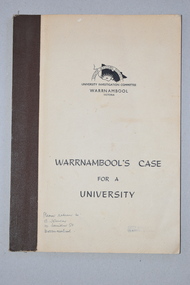
Booklet, Warrnambool's Case for a university, 1961
... This booklet has some historical significance as it contains the information collated on the campaign in Warrnambool and the Western District for a university to be established in the Warrnambool area. deakin university history of warrnambool This is a soft cover booklet of 48 pages. It has a beige-coloured cover with black printing. The booklet has been bound with brown tape. It has printed information, black and white photographs, a fold-out map ...The information in this booklet was prepared by a University Investigation Committee formed in Warrnambool in 1961 to present the case for the establishment of a university in the Warrnambool area. The chairman of this committee was the Mayor of Warrnambool, Cr P. O’Sullivan and the secretary was W. L. George of Warrnambool. This submission was unsuccessful at the time but campaigning for a university continued. In 1961 Warrnambool Technical School in Timor Street was offering both secondary and tertiary courses in the technical and trades areas and in 1969 the tertiary section of this Technical School became the Warrnambool Institute of Advanced Education. The tertiary section was relocated in 1984 to Sherwood Park, a 94 hectare site on the Princes Highway five kilometres from Warrnambool’s C.B.D. In 1990 Deakin University established a regional campus at Sherwood Park after a merger with the Warrnambool Institute of Advanced Education. This booklet has some historical significance as it contains the information collated on the campaign in Warrnambool and the Western District for a university to be established in the Warrnambool area.This is a soft cover booklet of 48 pages. It has a beige-coloured cover with black printing. The booklet has been bound with brown tape. It has printed information, black and white photographs, a fold-out map, graphs and tables.deakin university, history of warrnambool -
 Warrnambool and District Historical Society Inc.
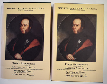
book - Books, Eagle Press, Mitchell's Three Expeditions into Eastern Australia, 1996
... Western District and the subsequent settlement of Warrnambool Major Mitchell Australia Felix Squatting Period Major Thomas Mitchell historical writing. To Peter Gunn (died 2021) with kind regards Brian H. Kelly Transferred to James Affleck Nov 22 Regards Brian H Kelly This is set number 223 of two facsimile volumes of an historical work. The covers are green with gold printing and the dust covers are cream with black printing and two colour illustrations. The pages contain printed text and illustrations, both black and white and coloured. There are two inserts, one a map ...Major Thomas Mitchell historical writing.This is set number 223 of two facsimile volumes of an historical work. The covers are green with gold printing and the dust covers are cream with black printing and two colour illustrations. The pages contain printed text and illustrations, both black and white and coloured. There are two inserts, one a map and the other showing a New South Wales natural feature. The two volumes are contained in a hardcover green folder.non-fictionMajor Thomas Mitchell historical writing.major mitchell, australia felix squatting period -
 Warrnambool and District Historical Society Inc.
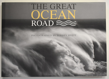
Book, Rodney Hyett, The Great Ocean Road, 2013
... District Historical Society Inc. 2 Gilles Street (south of Merri St) Warrnambool great-ocean-road This book contains photographs of the Great Ocean Road taken by Rodney Hyett, a photographer who produces books and calendars featuring coastal views of the Great Ocean Road. The book contains his best images from 15 years of calendar making and includes mostly black and white photographs together with historical engravings, maps and diaries dating back to the early history of the region. This book is of interest as it contains finely-executed photographs of the Great Ocean Road. Warrnambool is situated at the western ...A book containing Great Ocean Road PhotographsThis is a book of 144 pages. The cover is buff-coloured with an embossed title. The dust cover has a black and white photograph and a map with white, yellow and black printing. The pages contain printed text and black and white and colour photographs amd mapsnon-fiction A book containing Great Ocean Road Photographsgreat ocean road, rodney hyett photographer -
 Warrnambool and District Historical Society Inc.
Book, Pam Marriott (publisher), Top Dog of the West, 2017
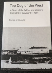
... Western District 19th Century History Western District Civil Service 19th Century History of Warrnambool This is a soft cover book of 480 pages. The cover and spine are white, with a black and white photograph and black printing. The pages include an introduction, eleven chapters of printed material, an index, a bibliography and appendices. There are several black and white photographs, plans, maps ...This book, written by Pam Marriott, is subtitled ‘A Study of the Belfast and Western District Civil Service 1841-1886’. It contains information on the police, police magistrates, court officials, customs and immigration officials etc who lived and worked in the Port Fairy and Warrnambool districts in the 19th century and many of the incidents and events with which they were connected. The book includes much information that is relevant to Warrnambool’s past. This book is an important acquisition to the Warrnambool & District Historical Society library as it contains information on many 19th century Warrnambool personalities, including policemen and court officials. It also has detailed information on some events that occurred in the Warrnambool district in the 19th century. This is a soft cover book of 480 pages. The cover and spine are white, with a black and white photograph and black printing. The pages include an introduction, eleven chapters of printed material, an index, a bibliography and appendices. There are several black and white photographs, plans, maps and other illustrative material. western district 19th century history, western district civil service 19th century, history of warrnambool -
 Warrnambool and District Historical Society Inc.
Book, Press Here, Ocean Grove, Lemnos 1915, 2011
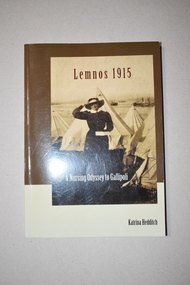
... Western District nurses during World War One. Western Victorian Nurses in World War One Sr Hope Weatherhead, Warrnambool A history of lives and work of the 130 Australian World War One nurses on the island of Lemnos. This is a soft cover book of 195 pages. It has a cover with a cream and brown background and a black and white photograph on the front cover and a map ...A history of lives and work of the 130 Australian World War One nurses on the island of Lemnos.This is a soft cover book of 195 pages. It has a cover with a cream and brown background and a black and white photograph on the front cover and a map and printed material on the back cover. The printing on the front is white, black and brown. The book has an introduction, four sections of printed material, an appendix, acknowledgements, abbreviations, bibliography and an index. The pages contain several black and white photographs.non-fictionA history of lives and work of the 130 Australian World War One nurses on the island of Lemnos.western victorian nurses in world war one, sr hope weatherhead, warrnambool -
 Warrnambool and District Historical Society Inc.
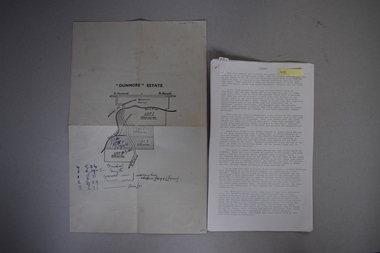
Map and Article, Dunmore, 1 1954 .2 1970
... Warrnambool and District Historical Society Inc. 2 Gilles Street (south of Merri St) Warrnambool great-ocean-road Both these items deal with the property of Dunmore, in the Macarthur/Hawkesdale/ Woolsthorpe area of Western Victoria. The first item is a sheet of paper with a map ...Both these items deal with the property of Dunmore, in the Macarthur/Hawkesdale/ Woolsthorpe area of Western Victoria. The first item is a sheet of paper with a map and details of the sale of portion of Dunmore in 1954. This is an original document. The second item is a history written by Stan Baulch of the property Dunmore from its establishment up to 1970. Dunmore was first established by Charles Hamilton MacKnight and two partners in 1842 and it was purchased by Samuel Baulch in 1893. After Samuel Baulch’s death the property was bequeathed to his three sons. One son, Stanley Baulch (1897-1980) took over the eastern portion which he named Rose Park. Stan Baulch was a member of the Warrnambool and District Historical Society and wrote several articles on aspects of his life and work, including this valuable article on the history of Dunmore. These items are of significance as they concern the estate of Dunmore in Western Victoria, an early and important property which is still farming land today under various owners. .1 This is a sheet of paper containing a map of the Dunmore property on one side and details of the sale of portion of Dunmore on the other side. The map has been annotated in handwritten black ink. The page has been folded twice. .2 This is an article typed on 12 foolscap pages. The typing is somewhat faint in places. ‘Dunmore’ Estate Dunmore baulch family, western district, victoria, dunmore estate, macarthur/hawkesdale, history of warrnambool -
 Warrnambool and District Historical Society Inc.
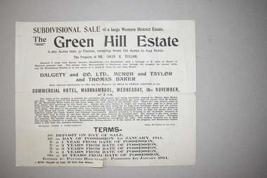
Documents (2), 1 1915 .1 1910
... These items are of minor interest and will be useful to researchers as they show the sizes and some owners of some early 20th century Western District properties. western district estates warrnambool olongolah estate green hills estate The Green Hills Estate Western District Estate ‘Olangolah’ .1 A single sheet of white paper with a map or plan of a property and black printing. ...These documents come from a collection of material from the Baulch families of Dunmore and Rose Park estates in Western Victoria in the Macarthur district. They concern the sales of the Green Hills Estate (1910) and the Olangolah estate (1915) near Woolsthorpe. Both were offered for sale by the owner, Colin Tulloh. The properties bordered on Baulch property belonging to Stan Baulch (1897-1980) and hence this is the reason for their being included in Baulch estate material. These items are of minor interest and will be useful to researchers as they show the sizes and some owners of some early 20th century Western District properties. .1 A single sheet of white paper with a map or plan of a property and black printing. The paper is creased and torn slightly at the edges. 2 A single sheet of white paper with a map of a property on one side and black printing on the other. The paper is creased and torn at the edges. The Green Hills Estate Western District Estate ‘Olangolah’ western district estates, warrnambool, olongolah estate, green hills estate -
 Warrnambool and District Historical Society Inc.
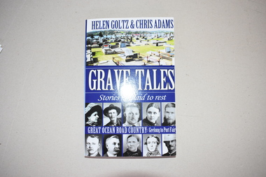
Book, Grave Tales, 2017
... It will be useful to researchers. western district of victoria warrnambool jack denham agnes ruttleton william sharrock rutledge brothers mills brothers frank burnet william mclean This is a soft cover book of 290 pages. It has black and white and coloured photographs on the front and back covers and printing on the spine and back and front covers. The pages contain an introduction, 22 chapters, black and white photographs and maps ...This book details the lives of some people of the past who are buried in cemeteries along the Great Ocean Road. Of particular interest to Warrnambool and district readers are the documented lives of Jack Denham of the La Bella shipwreck, early Warrnambool settlers, Agnes and James Ruttleton, William Sharrock, hero of the Nestor sinking, the Rutledge brothers and the Mills brothers of Port Fairy, the scientist Frank Burnet, the unionist William McLean, Dick the bushranger and Captain Pye, V.C. This book is of interest as it gives information on a variety of historical figures buried in cemeteries in the Great Ocean Road districts (Geelong to Port Fairy). It will be useful to researchers. This is a soft cover book of 290 pages. It has black and white and coloured photographs on the front and back covers and printing on the spine and back and front covers. The pages contain an introduction, 22 chapters, black and white photographs and maps and illustrations. western district of victoria, warrnambool, jack denham, agnes ruttleton, william sharrock, rutledge brothers, mills brothers, frank burnet, william mclean -
 Warrnambool and District Historical Society Inc.
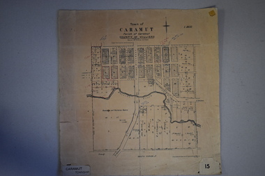
Map, Department of Lands and Survey (Lithographers), Caramut township, 1938
... This map of the township of Caramut was produced in 1938 but shows the original land owners of each town allotment and of the surrounding area. The size of all the allotments and the date of the original purchase are also shown. Caramut is a Victorian Western District...Warrnambool and District Historical Society Inc. 2 Gilles Street (south of Merri St) Warrnambool great-ocean-road This map of the township of Caramut was produced in 1938 but shows the original land owners of each town allotment and of the surrounding area. The size of all the allotments and the date of the original purchase are also shown. Caramut is a Victorian Western ...This map of the township of Caramut was produced in 1938 but shows the original land owners of each town allotment and of the surrounding area. The size of all the allotments and the date of the original purchase are also shown. Caramut is a Victorian Western District town on Mustons Creek on the Hamilton Highway 48 kilometres from Warrnambool. This map was used by Rolf Crawley when he was the engineer for the Shire of Warrnambool from 1935 to 1968. The annotations on the map have probably been made by Rolf Crawley as they refer to the records and letter books of his father, John William Crawley, Junior (Shire of Warrnambool Engineer 1895 to 1935). Both Rolf Crawley and his father, John had private businesses as architects, surveyors and engineers and the map could have been used in connection with both their official Shire duties and their private businesses. The last owner of the map was the surveyor, Michael Hand who took over the business of Rolf Crawley in the late 1960s. This map is of great interest firstly because it has all the historical details of the land first purchased in the town of Caramut and area and secondly because it came from the office of Rolf Crawley, the engineer for the Shire of Warrnambool from 1935 to 1968. This is a buff-coloured paper map with a cloth backing. The map details are in black and white print. There are some handwritten red and black annotations on the map. “Town of Caramut Parish of Caramut County of Villiers’town of caramut, john william crawley junior, warrnambool, rolf crawley, warrnambool -
 Warrnambool and District Historical Society Inc.
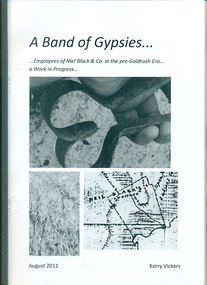
Booklet, A band of gypsies: employees of Niel Black & Co in the pre-goldrush era: a work in progress
... Western District of Victoria who held large tracts of land including Glenormiston and The Sisters estates. Black was responsible for bringing many employees to the area. The employees' names, birthplace, arrival date, marriage partner/s, other employers are tabulated. An overview of Black's properties and conditions of the time is also included. This booklet documents those who came to the Western District to work for Niel Black prior to the goldrushes of the 1850s. emigration employment family history early victorian squatters niel black In-house booklet with plastic sleeve outer cover, with black & white images of sheep shears, wool and a map of the Black property. ...Niel Black was an early settler in the Western District of Victoria who held large tracts of land including Glenormiston and The Sisters estates. Black was responsible for bringing many employees to the area. The employees' names, birthplace, arrival date, marriage partner/s, other employers are tabulated. An overview of Black's properties and conditions of the time is also included.This booklet documents those who came to the Western District to work for Niel Black prior to the goldrushes of the 1850s.In-house booklet with plastic sleeve outer cover, with black & white images of sheep shears, wool and a map of the Black property. All text is in black.emigration, employment, family history, early victorian squatters, niel black -
 Warrnambool and District Historical Society Inc.
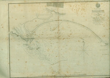
Document, Map: Lady Bay 1853, 1853
... Warrnambool and District Historical Society Inc. 2 Gilles Street (south of Merri St) Warrnambool great-ocean-road This is one of the earliest surveys and maps of Warrnambool harbor, Lady Bay. Being done in 1853, it shows the depths of the bay area marked in fathoms, currents and directions and areas of rocks around mouth of the Merri and the Western side of the bay as well as a large sand spit to the middle right of the beach region.. ...This is one of the earliest surveys and maps of Warrnambool harbor, Lady Bay. Being done in 1853, it shows the depths of the bay area marked in fathoms, currents and directions and areas of rocks around mouth of the Merri and the Western side of the bay as well as a large sand spit to the middle right of the beach region.. It also marks the large areas of seaweed and fuci in the outer bay area. It has the area of Pertobe Lagoon marked and shows the early tracks to the town. The engraving work was done by Tulloch and Brown, with Tulloch being one of the earliest engravers and lithographers in the state of Victoria. He arrived in Melbourne in 1849 and set up business with James Davie Brown in 1853 with Brown being a map engraver. They were awarded bronze and silver medals for their work at the Victorian Industrial Exhibition. He also worked in the vignettes on the Proeschel Map of Victoria.This map is of high historical and comparitive significance as it shows the Lady Bay area prior to the changes that have occurred in the last 160 years with the building of the breakwater. The issue regarding access to Lady Bay remains a current one. The engraver D Tulloch engraved some of the earliest scenes of the goldfields in Ballarat and as such has left a record of a very early and important era in Australian history. Rectangular cream paper with black text. Map area is outlined by fine black lined border. Key in top right hand corner and scale at bottom middle of map.Map is labelled Town of Warrnambool printed at top of map. Small logo at top right corner which has “Hydrographic Department” in circle around an anchor. Lady Bay Warrnambool Surveyed by John Barrow assistant surveyor Engraved by Tulloch & Brown in bottom right corner. Melbourne engraved by order of the legislative Council of Victoria in middle bottom.map, warrnambool, town of warrnambool map 1853, tulloch & brown map 1853, lady bay warrnambool,, warrnambool harbour, warrnambool breakwater, warrnambool beach -
 Warrnambool and District Historical Society Inc.
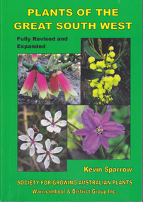
Book, Star Printing Terang Victoria. 978-0-9751360-1-0, Plants of the Great South West 2013 Second Edition, 2013
... Warrnambool and District Historical Society Inc. 2 Gilles Street (south of Merri St) Warrnambool great-ocean-road Second edition (revised a& expanded edition) First edition 2004. Guide to the indigenous plants of South West Victoria. South West Victoria: Nelson – Port Campbell. Zone A.B.C & D. Local maps Bioregions plantsof western ...Second edition (revised a& expanded edition) First edition 2004. Guide to the indigenous plants of South West Victoria. South West Victoria: Nelson – Port Campbell. Zone A.B.C & D. Local maps BioregionsCard cover green) gloss white paper. End papers. Map 1&2. 6 pages credits, title, table of contents, forward, acknowledgements, disclaimer, websites. 348 pages. Colour maps & photographs. References & reading. Index plantsof western victoria, kevin sparrow, warrnambool -
 Warrnambool and District Historical Society Inc.
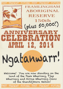
Booklet - 150 plus Framlingham Aboriginal Reserve, 2014
... The celebration of the 150th anniversary of Framlingham’s establishment in 2014 was therefore a significant event in the district’s history and the booklet is a permanent reminder of this. framlingham aboriginal trust western district aborigines peek whurrong kirrae whurrong gunditjmara tjap whurrong Front cover: ‘Framlingham Aboriginal Reserve 150th Anniversary Celebration, April 12, 2014, Ngatanwarr’ etc Back cover: Acknowledgements of sponsors and written material This is a small booklet of 8 pages containing information on the 150th celebrations of Framlingham Aboriginal Reserve in 2014. The cover has a cream background with illustrations and printed material in yellow, black and brown. The pages are stapled. The booklet includes photographs, maps ...The Framlingham Aboriginal Trust is a shareholder- owned organization established under Victorian law in 1971. The Trust owns and manages part of what was the old Aboriginal Reserve established in 1861 under the auspices of the Church of England. In 1865 the Reserve was officially established as a Government-managed aboriginal station. By 1970 the original area of 3,500 acres was whittled down to 585 acres and handed over to the Framlingham Aboriginal Trust. Framlingham is today one of only two discrete aboriginal communities in Victoria where aborigines live on aboriginal land and is an important part of the district cultural life. The celebration of the 150th anniversary of Framlingham’s establishment in 2014 was therefore a significant event in the district’s history and the booklet is a permanent reminder of this.This is a small booklet of 8 pages containing information on the 150th celebrations of Framlingham Aboriginal Reserve in 2014. The cover has a cream background with illustrations and printed material in yellow, black and brown. The pages are stapled. The booklet includes photographs, maps, illustrations and printed material. Front cover: ‘Framlingham Aboriginal Reserve 150th Anniversary Celebration, April 12, 2014, Ngatanwarr’ etc Back cover: Acknowledgements of sponsors and written material framlingham aboriginal trust, western district aborigines, peek whurrong, kirrae whurrong, gunditjmara, tjap whurrong -
 Warrnambool and District Historical Society Inc.
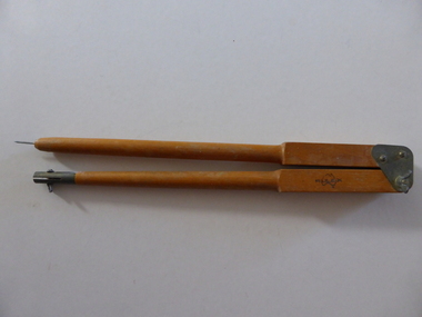
Artefact, Black board compass, c. 1950
... western district history of warrnambool blackboard compass ‘Rulex’ This is a wooden blackboard compass with two wooden prongs hinged at the top end with three metal screws. The other end of one prong has a pointed nail protruding for fixing to a blackboard or whiteboard and the end of the other prong has a metal part around the tip of the prong with a metal screw for adjustment and a hollow part to insert chalk or other large writing medium. The maker’s name and an outline of a map ...This compass would have been used in a school or other educational institution for drawing a circle or part circle on a blackboard or whiteboard. A compass similar to this has been used in schools for many decades and may still be used. This school blackboard compass has no known local provenance but was a common classroom item and will be useful for display.This is a wooden blackboard compass with two wooden prongs hinged at the top end with three metal screws. The other end of one prong has a pointed nail protruding for fixing to a blackboard or whiteboard and the end of the other prong has a metal part around the tip of the prong with a metal screw for adjustment and a hollow part to insert chalk or other large writing medium. The maker’s name and an outline of a map of Australia are engraved into the top part of one of the prongs. ‘Rulex’ education in the western district, history of warrnambool, blackboard compass -
 Warrnambool and District Historical Society Inc.
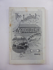
Journal, The Journal of the Department of Agriculture of Victoria April 1902, 1902
... Western District Koroit Dairying Warrnambool History This is a soft cover booklet of 102 pages - pages 350 to 452 of Part 4 of a journal published monthly. The back cover is missing. The front cover is black and white and has an inset of a photograph showing wheat harvesting. The booklet is bound with cotton thread and shows rust where the thread is tied, perhaps from metal staples now removed. The cover has a slight tear and there is some staining throughout the pages. The booklet contains maps ...This booklet has been produced in April 1902 for the Government of Victoria under the direction of the Minister for Agriculture, Hon John Morrissey M.L.A. It contains articles on agriculture in Victoria, including the dairying industry in the Western District. This journal is of some interest because of the photographs and information on dairying in the Western District in the early 20th century, including dairy inspection, milking controls in Koroit, prize-winning cows at Koroit and dairy bacteriology. This is a soft cover booklet of 102 pages - pages 350 to 452 of Part 4 of a journal published monthly. The back cover is missing. The front cover is black and white and has an inset of a photograph showing wheat harvesting. The booklet is bound with cotton thread and shows rust where the thread is tied, perhaps from metal staples now removed. The cover has a slight tear and there is some staining throughout the pages. The booklet contains maps, diagrams, sketches and black and white photographs. dairying in the western district, koroit dairying, warrnambool history -
 Warrnambool and District Historical Society Inc.
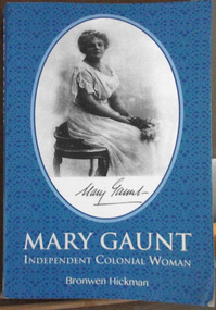
Book, Bronwen Hickman, Mary Gaunt: independent colonial woman, 2014
... Western District settings. Mary Gaunt Australian Literature History of Warrnambool Biography of novelist and travel writer, Mary Gaunt (1862-1942) This is a soft cover book of 304 pages. It has a blue cover with a black and white photograph of Mary Gaunt in an oval shape on the front cover. There is white lettering on the front cover and black lettering in an oval shape on the back cover. The book has an introduction, 35 chapters, acknowledgements, endnotes, a list of publications and an index. It has several illustrations, sketches, maps ...Biography of novelist and travel writer, Mary Gaunt (1862-1942)This is a soft cover book of 304 pages. It has a blue cover with a black and white photograph of Mary Gaunt in an oval shape on the front cover. There is white lettering on the front cover and black lettering in an oval shape on the back cover. The book has an introduction, 35 chapters, acknowledgements, endnotes, a list of publications and an index. It has several illustrations, sketches, maps and black and white and colour photographs,non-fictionBiography of novelist and travel writer, Mary Gaunt (1862-1942)mary gaunt, australian literature, history of warrnambool -
 Warrnambool and District Historical Society Inc.
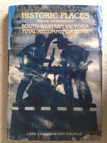
Book, Historic Places of South West Victoria
... District Historical Society Inc. 2 Gilles Street (south of Merri St) Warrnambool great-ocean-road This is the third in a series of booklets produced by the Land Conservation Council in 1997 (176 pages). Booklets One and Two (1996) contained A Descriptive Report and Proposed Recommendations. The Final Recommendations include information on processes for protection of historic places, lists of significant places in the south-western region and aboriginal historic places. Attached inside the back cover are two maps ...This is the third in a series of booklets produced by the Land Conservation Council in 1997 (176 pages). Booklets One and Two (1996) contained A Descriptive Report and Proposed Recommendations. The Final Recommendations include information on processes for protection of historic places, lists of significant places in the south-western region and aboriginal historic places. Attached inside the back cover are two maps showing the location of the significant places.This is a useful book as it lists the declared historic sites in the region and researchers will find the information helpful. This is a soft-cover book with a multi-coloured cover featuring a photograph of the Pioneers Memorial, Deep Lead. It has a red-coloured spine and back cover.Front Cover – Historic Places - Special Investigation - South-Western Victoria - Final Recommendations – Land Conservation Council Spine – Historic Places – South-Western Victoria – Final Recommendations – Land Conservation Council Back Cover – Historic Places, Final Rec., code used for retail sales warrnambool, south west historic places, aboriginal historic places -
Federation University Historical Collection
Document, Zelda Martin, Central Victorian Goldmining towns - Boom Towns or Ghost Towns?, c1996
... Western Highway a few miles out of Horsham. Pg 15 - Ballarat Excursion - re the finding of gold. *Three articles published by Buninyong and District Historical Society Inc: (Magpie Exploration; Finding Gold In The Green Hills; Magpie Exploration; Burnt Bridge to Cargarie to Mt Mercer) *Copies of newspaper articles/items *Buninyong Street Directory Carisbrook: *In the Beginning There Was Carisbrook *The History of the Carisbrook Racecourse Carngham / Snake Valley: *Brief History *Directory Castlemaine: *Directory 1865-1866 - Alphabetical and Street *Poster - Castlemaine A Contemporary Guide "The Great Centre" 1866 - A Contemporary Guide to the Fascinating Past *Pamphlet - Castlemaine District Community Hospital *Map - Castlemaine, Maldon & Surrounding Districts *Map and Information - The Dry Diggings Track - a 55kl walk among historic goldfields relics ( Castlemaine Fryerstown Vaughan Mt Franklin Hepburn Daylesford) *Postcard - Former Court House *Directory 1867 - Alphabetical, Trade [.10] Resource No.3 Grey folder Titled Towns 3 Creswick to Maryborough Creswick: *Brief History *Booklet - "Creswick Cemetery Walk" *Booklet - The Buried Rivers of Gold Heritage Trail Creswick *Creswick Historical Museum Information Sheet *Chronological History of Creswick *Alphabetical Directory of the Borough of Creswick *Creswick's Creek Directory 1856 *Historic Creswick Walking Tour *A Brief Account of the Schools of Creswick - Past and Present *100 Years of Railway Travel in Creswick *The Berry Deep Leads *The Spence Home at Jackass Gully in the Creswick State Forest ( William Guthrie Spence - Pioneer) *The New Australian Mine and the 1882 Disaster *Creswick District News, Issue 7, July August 1999 *The Creswick Miners Walk - Information and Map *Maps Chewton: *Brief History *Directory Clunes: *Brief History *Clunes Street Directory Daylesford: *Brief History *Notable Bushfires in Daylesford District Over More Than a Century - "Black Thursday" 1851; 1862; 1899; the Disastrous Hepburn Fire of 1906; 1939; 1944; 1969. ...Western Highway a few miles out of Horsham. Pg 15 - Ballarat Excursion - re the finding of gold. *Three articles published by Buninyong and District Historical Society Inc: (Magpie Exploration; Finding Gold In The Green Hills; Magpie Exploration; Burnt Bridge to Cargarie to Mt Mercer) *Copies of newspaper articles/items *Buninyong Street Directory Carisbrook: *In the Beginning There Was Carisbrook *The History of the Carisbrook Racecourse Carngham / Snake Valley: *Brief History *Directory Castlemaine: *Directory 1865-1866 - Alphabetical and Street *Poster - Castlemaine A Contemporary Guide "The Great Centre" 1866 - A Contemporary Guide to the Fascinating Past *Pamphlet - Castlemaine District Community Hospital *Map - Castlemaine, Maldon & Surrounding Districts *Map and Information - The Dry Diggings Track - a 55kl walk among historic goldfields relics ( Castlemaine Fryerstown Vaughan Mt Franklin Hepburn Daylesford) *Postcard - Former Court House *Directory 1867 - Alphabetical, Trade [.10] Resource No.3 Grey folder Titled Towns 3 Creswick to Maryborough Creswick: *Brief History *Booklet - "Creswick Cemetery Walk" *Booklet - The Buried Rivers of Gold Heritage Trail Creswick *Creswick Historical Museum Information Sheet *Chronological History of Creswick *Alphabetical Directory of the Borough of Creswick *Creswick's Creek Directory 1856 *Historic Creswick Walking Tour *A Brief Account of the Schools of Creswick - Past and Present *100 Years of Railway Travel in Creswick *The Berry Deep Leads *The Spence Home at Jackass Gully in the Creswick State Forest ( William Guthrie Spence - Pioneer) *The New Australian Mine and the 1882 Disaster *Creswick District News, Issue 7, July August 1999 *The Creswick Miners Walk - Information and Map *Maps Chewton: *Brief History *Directory Clunes: *Brief History *Clunes Street Directory Daylesford: *Brief History *Notable Bushfires in Daylesford District Over More Than a Century - "Black Thursday" 1851; 1862; 1899; the Disastrous Hepburn Fire of 1906; 1939; 1944; 1969. ...Zelda Martin was a PhD candidate at the University of Melbourne.[.1] 4th item in light blue display book titled Research Approach/Overview of Chapters/Confirmation of Canditure/Chapters1,2,3&4 of proposed thesis. *Twenty-seven page article on Victorian goldfields towns titled: Central Victorian Goldmining Towns - Boom Towns or Ghost Towns. The article was written during the author's PhD study. It outlines the context methodology, and resources and the chapters of the proposed thesis: (1) Central Victorian Goldmining Towns - The Context (2) Contemporary Views of the Factors Necessary for Town Growth (3) Outward Manifestations of Town Growth (4) The Trappings of Government (5-9) The Main Towns and Their Hinterland. [.2] 5th item in Light Blue display book as above item. *Chapter 1 of proposed thesis titled 'Pick, Shovel and Tin Dish Mining.' Covers in Section A: Central Victoria - Pre 1851: Aborigines in Central Victoria, Squatters, and Government. Section B: The years 1851-1854: The Early Gold Rushes, Government Reaction, Township Surveys, Legislation, Town Development, Local Government and Early Settlement. [.3] 6th item in Light Blue display book as above item. *2A of proposed thesis titled 'Contemporary Views of the Factors Necessary for Town Growth'. Similar information to Chapter 1 plus extra re towns and maps. Sections: Introduction, Context of Place - Geographical Towns Listed, The Context of Time - Pre1851 Aborigines, Governance of Port Phillip, The Squatters, The Villages of Central Victorian Highlands, Conclusion, Condensed Version of Chapter2B. [.4] 7th item in Light Blue display book as above item. *Chapter2B of proposed thesis. Sections: Area of Research, Schools, Banks, Newspapers, Progress Association, Town Development - Sandhurst (Bendigo), Ballarat, Castlemaine,, Maryborough, Ararat and Stawell. [.5] 8th item in Light Blue display book as above item. *Chapter 3 of proposed thesis titled 'Outward Manifestations of Town Growth'. Sections: Introduction, Contemporary Writing, Educationalists, The Bankers, The Townsfolk, Current Theory, General Theories of Urban Development, and Conclusion. [.6] 9th item in Light Blue display book as above item. *Chapter 4 of proposed thesis titled 'Trappings of Government' Sections: Introduction, Early Government Attitudes to Mining and Town Development, Law and Order, Township Surveys, Legislation, Local Government, Transport and Communication, The People and Lobbyists. [.7] 10th item in Light Blue display book as above item. *'The Rise and Fall of Central Victorian Goldmining Towns'. Includes a map showing main Goldfields, a table showing towns and villages at two points in time - 1857 and 1871; a Bibliography of Primary and Secondary Sources. [.8] Resource No1. Black display book titled Local Towns 1 : Alma: *Brief history *Directory *Maps Amphitheatre / Mountain Hut: *Brief History Post Office Directory Ararat: *Brief History *Post Office Directory 1869 - Alphabetical Listing by Occupation *Ararat - Prominent Citizens of 1858 *Langi-Morgala Museum Avoca: *Brief History *Excerpts from 'Avoca The Early Years', Margery and Betty Beavis; pg1 - Beginnings; pg11 - The Midas Touch; pg25 - Local Gold Escorts; pg27 - A Town is Born; pg51- The Administration of Justice; pg53 - The Ways of the Law; pg61 - News of the Day; pg65 - A Time to Play; pg72 - Land Ownership *Post Office Directory (Bailliere's) 1869 *Tourism Map and Information of area *Historic Avoca - A 5.5km Tour *Avoca & the Pyrenees Region - information pamphlet Ballarat: *Early History of Ballarat - Ballarat Historical Society, Publication No.1: origin of the name; Ballaarat - the Beginning; Fabulous Yields from the Ballaarat Goldfield; *Streetscape Lydiard Street. *Hand drawn map showing Leigh River, Old Portland Bay Road, plaque on road to Colac; etc. *Newspaper article re 'The Theatre Royal' ( which stood in the vicinity of the current Owen Williams store) - 'The News'15/04/1998 *Article - 'Ballarat's Mechanics' Institute Lives On' Ballarat Courier, 14/09/1985 *Article - Standing the Test of Time' The News 17/11/1993 re The Mechanics Institute & picture of the Reading Room *'Ballarat a Study of a City, Phyllis Reichl, pub. Nelson, 1968; no.3 place, time and people field studies series *Investigator Vol.33 No.2, 1998 Geelong Historical Society. Article on pg75 describes Ballarat in 1861 *Folded poster - 'Ballarat 100' a history of telegraph communication, pub. Telecom. Beaufort (Fiery Creek): *Brief history *Post Office Directory [.9] Resource No.2 Black Folder Titled Towns cont.No2 Bendigo (Sandhurst): *'Family & Local History at the Bendigo Library - 1851-2001 150 years of gold'. *Bendigo Government Camp in 1853 illustration; key to sketch and names of Government officers stationed there *Excerpts from 'Bendigo and Vicinity' Adolph Haman *The Bendigo Goldfield Registry - pgs 1-7 Introduction *Excerpt: 'Breaking the Grip' *Excerpt: The Most Go-Ahead Place *Excerpts from 'History of Bendigo' - anti license agitation; laying out of town; proposed railway; gold calls and dividends; the Sandhurst Municipality; journalism *Bibliography Blackwood: *Excerpts from 'Aspects of Early Blackwood - The Goldfield, the Landmarks, the Pioneers' Alan J Buckingham and Margaret F Hitchcock, JG Publishing,1980 Buninyong: *A Brief History *Investigator Vol1 No.2 Feb 1966 Geelong Historical Society. Pg3 - Article re gold escort route - Mt Alexander to Adelaide - (see a simple monument on the Western Highway a few miles out of Horsham. Pg 15 - Ballarat Excursion - re the finding of gold. *Three articles published by Buninyong and District Historical Society Inc: (Magpie Exploration; Finding Gold In The Green Hills; Magpie Exploration; Burnt Bridge to Cargarie to Mt Mercer) *Copies of newspaper articles/items *Buninyong Street Directory Carisbrook: *In the Beginning There Was Carisbrook *The History of the Carisbrook Racecourse Carngham / Snake Valley: *Brief History *Directory Castlemaine: *Directory 1865-1866 - Alphabetical and Street *Poster - Castlemaine A Contemporary Guide "The Great Centre" 1866 - A Contemporary Guide to the Fascinating Past *Pamphlet - Castlemaine District Community Hospital *Map - Castlemaine, Maldon & Surrounding Districts *Map and Information - The Dry Diggings Track - a 55kl walk among historic goldfields relics ( Castlemaine Fryerstown Vaughan Mt Franklin Hepburn Daylesford) *Postcard - Former Court House *Directory 1867 - Alphabetical, Trade [.10] Resource No.3 Grey folder Titled Towns 3 Creswick to Maryborough Creswick: *Brief History *Booklet - "Creswick Cemetery Walk" *Booklet - The Buried Rivers of Gold Heritage Trail Creswick *Creswick Historical Museum Information Sheet *Chronological History of Creswick *Alphabetical Directory of the Borough of Creswick *Creswick's Creek Directory 1856 *Historic Creswick Walking Tour *A Brief Account of the Schools of Creswick - Past and Present *100 Years of Railway Travel in Creswick *The Berry Deep Leads *The Spence Home at Jackass Gully in the Creswick State Forest ( William Guthrie Spence - Pioneer) *The New Australian Mine and the 1882 Disaster *Creswick District News, Issue 7, July August 1999 *The Creswick Miners Walk - Information and Map *Maps Chewton: *Brief History *Directory Clunes: *Brief History *Clunes Street Directory Daylesford: *Brief History *Notable Bushfires in Daylesford District Over More Than a Century - "Black Thursday" 1851; 1862; 1899; the Disastrous Hepburn Fire of 1906; 1939; 1944; 1969. *Post Office Directory -Daylesford and Hepburn Dunolly / Inkerman: *Brief History *Directory *Pamphlet - Goldfields Historical Museum *Pamphlet - Historic Dunolly - Victoria's Best Kept Secret *Map of Gold Workings at Dunolly Area - showing where the main gold rushes occurred *Brief History - Inglewood *Directory - Inglewood - Name Occupation, Dwelling Kingower: *Brief History *Directory - Name / Ocupation / Dwelling Linton / Happy Valley / Piggoreet: *Brief History *Directory - Lintons McIvor: *"A History of the Shire and the Township of Heathcote" by J.O. Randell Majorca: *Brief History *Official Post Office Directory 1869 - Name / Occupation/ Address Maldon (Tarrangower): *Brief History Part 1 *Brief History Part 2 *Post Office Directory *List - Alphabetical Order by Names plus Business and Trade (Tarrangower Times Oct/1858) *List - Alphabetical Order by Trade plus Name and Business *Directory - Name / Occupation / Dwelling Maryborough: *Worsley Cottage - built by Arthur Worsley, a contractor in stonework in 1894 [.11] Resource No. 4 Blue Display Book titled Towns 4 Moliagul to Stawell Moliagul: *Brief History *Moligul Legislative Assembly (Voting?) List - Names and Occupations *Moliagul Victorian Post Office Directory 1868 - Name / Ocupation / Address / Comments *"The Welcome Stranger" gold nugget *The Sunday School *The Welcome Stranger Discovery Walk - information and map Moonambel (Mountain Creek) Redbank *Brief History *List of names extracted from advertisments of the Pioneer and Mountain Creek Advertiser 16/02/1861. *Bailliere's Directory 1869 - Alphabetical List of Name / Occupation / Place St Arnaud: *Brief History Sebastapol: *Brief History *Directory 1869 - Alphabetical by Name; plus occupation and address. Browns and Scarsdale: *Brief History *Browns Street Directory - Name and Occupation Smythesdale: *Brief Description *Smythesdale Street Directory -Name and Occupation Stawell (Pleasant Creek) *Brief History *Victorian Official Post Office Directory - Name /Occupation / Dwelling *Chronology - 1841-1920 *Production of gold statistics - 1879 - 1900 *Big Hill *Extracts from "The Golden Years of Stawell". Chapt 1 - Stawell's Coming Out. Capt. 2 - The Gold Rush. Caapt.3 - Cradle of Democracy. Chapt.4 - The Reefs Becomes Stawell. Chapt. 5 - Rushing In. Chapt.6 - The Pioneers. Chapt 7 - The Decade of Optimism. [.12] Resource No. 5: Blue Display Book titled 'Towns Steiglitz to the The Golden Triangle. Steiglitz: Brief History Victorian Post Office Directory 1869 *Map of Steiglitz *List of maps relevant to Steiglitz history *Information 6 tables of data from "Reports of Mining Surveyors Talbot (Back Creek) Brief History Taradale: Post office Directory 1869 - Name/Occupation/Street. Also list in alphabetical order by Occupation Taradale *Chronological Reference to Taradale Mines *Water - The Coliban System of Waterworks *Joseph Brady *The Syphon Tarnagulla (Sandy Creek) *Brief History *Tarnagulla Businessmen Cameos to give depth to advertisments in 'The Tarnagulla Courier' various issues 1864-1871 *Directory - Name/Occupation /Address *List - Name/Business/Trade Wedderburn (Koorong) *Brief History *List - Name/Occupation The Golden Triangle: *The Early Rushes - Wedderburn / Moliagul / Sandy Creek - Tarnagulla / Jones Creek - Waanyarra / Kingower / Dunolly - Goldsborough / Inglweood *Census of 1857 - Population / Occupations *1858-1871 - A Time of Consolidation- Wedderburn / Moliagul / Sandy Creek- Tarnagulla / Arnold *Census 1871 - Population *Information gleaned from the census data - Demographics / Population / Occupations / marital / Birthplace / Religion / Literacy/ Occupation and Housing Cameos *Graphs - Birthplace of settlers /Male-Female Ratio / Married males / Children under 15 as Percentage of Population / Religion *Census 1857 - Statistical data *Maps *Bibliography [.13] Resource No. 6 - Black Display Book Information and Research in Central Victoria including: *Banking - Research from ANZ Bank Archives *Institutions - also includes articles listed from the Ballarat Times Newspaper *Australian mining History Association - A.M.H.A. Bibliography *Australia's Mining History * Bibliography - Land Surveys Victoria - *1853 Administration (Statistics and Other) includes: schools / ministers of religion / police / military / local administration / licences for sale of spirits / distances between various Victorian gold fields. * Victoria Government Gazette (Copy) - N0. 116, 12/12/1854 includes: Gold Felds Commission of Enquiry & No. 85, 15/09/1854 - Addresses presented to the Lieutenant Governor (Sir Charles Hotham) during his tour through the Gold Fields of Victoria,1854. Addresses on behalf of : the people of Bendigo; Members of the Church of England, Bendigo; Members of the Wesleyan Church on the Bendigo Gold Fields; Bendigo Gold District General Hospital; the Bendigo Prospecting Association; Committee of the Bendigo Local Exhibition; Bendigo District Medical Association; Coloured Americans Resident at Bendigo; German Inhabitants of Bendigo; Landowners, Inhabitants, and Miners of Castlemaine; Inhabitants of Forest Creek; Inhabitants of Heathcote and Gold Miners of McIvor; Residents and landholders of the District of Bacchus Marsh; Inhabitants of Kilmore and Vicinity. *Gold Fields Correspondence 1853: letter from Lieutenant Colonel Valiant, (Officer commanding the Troops in Victoria) to the Lieutenant Governor re threatened disturbance at Sandhurst (Bendigo) regarding the Gold License Fee. * Extracts from a book "Victoria" re Gold Fields Commission of Enquiry involving mainly Ballarat and Castlemaine and a chapter titled 'A Tour to the Victorian Gold-Fields' *Lists of central Victorian newspapers - listed by date published 1851to 1874; by first date available to State Library. *A list of cities and towns showing County, population in 1861 &1871, and municipal status. [.14] Resource no.7. Black display book. *Reference: Papers presented to Parliament Victoria - 1859-1860 4 volumes - relevant sections copied. Contains information on Branches of Government. General / Finance / Gold / Gazette / Commission and Warrant / Statistic. *Gold Fields Act. In accordance with the Act the gold fields are divided into six districts - Ballaarat, Castlemaine , Sandhurst, Avoca, Ararat, and Beechworth.. Official staff in each gold district consists of a Resident Warden, Wardens, Wardens' Clerks, Bailiffs, Chinese Protectors, Chinese Interpreters, and Mining Surveyors. *Gold Receiver *Gaols *Police magistrates and Clerks of Petty Sessions, etc. *Field Branch *Immigration and Emigration Overland - Chinese - 1859 *Population on the Goldfields *The Geological Survey - The Government Geologist is assisited by staff from four branches - the office Branch; the Publishing Branch; the Field Branch and the Museum Branch. *Commission to Enquire Into Sludge dated 10/02/1859 (Some sections copied) - Report to the Honorable Chief Commissioner of Public Works, Melbourne re the mode of carrying the sludge from the puddling mills in Sandhurst without interfering with the drainage of the town and the roads in the neighbourhood. [.15] Resource No.8: Camel display book titled Resource No. 8. Aborigines *Lists of book titles - +"Readings in Victorian prehistory" +"The Aborigines of Port Phillip" +Aboriginal languages and clans" +"A History of the Port Phillip District" +"Langi Ghiran 1: Aboriginal Rock...." +"Koorie History: sources for aboriginal studies in the State Library of Victoria", ed. Tom Griffiths, Melb. Friends of the State Library, 1989 +"The Public Lands of Australia Felix"; settlement and land appraisal in Victoria1834-91 with special reference to the Western Plains", J.M.Powell, Melb. Oxford University Press 1970 +*Bibliography of the Victorian Aborigines' from the earliest manuscripts to 31st December 1970, Massoa, Aldo, Melb. Hawthorn Press, 1971 +"Aborigines in Colonial Victoria, 1836-1886", M.F. Christie, Sydney University Press, 1979 +"Urban and Industrial Australia: readings in Human Geography" ed J.M. Powell, Melb. Sorrett Pub. 1974 *Extracts: -Processes of Pioneer Settlement - The Squatting Occupation of Victoria, 1834-60. J.M. Powell -Areal Variations in the Class Structure of the Central-Place Hierarchy. P. Scott - Volume1 and Volume 2: Notes Relating to the Habits of the Natives of Other Parts of Australia and Tasmania. Compiled from various sources for the Government of Victoria by R Brough Smyth. John Curry, O'Neil, Melb. 1st pub. Melb. 1876. p31-45 - Numbers and Distribution of the Aborigines in Victoria -Victorian Aborigines 1835-1901 - A Resource Guide to the Holdings of the Public Record Office, Victoria; published by the Government Information Centre 1984. *History of the Aboriginal Artefacts Displayed in the Daylesford Museum. F. G. Powell (4 page pamphlet) *Letter to Zelda Martin from Peter Lovett, Cultural Officer, Ballarat & District Aboriginal Co- Operative, 05/02/1997 *Map: Ian Clarke Victorian Tribunal Boundary Map - Clans of Central Victoria. *Victorian Rock Art and Mythology - Article about Mount Langhi Ghiran and myths of the Tjapwarong people. *Two Aboriginal myths relating to the Grampians - 'The Monster Emu' / 'The Aquisition of Fire', by the Aborigines in the Grampians Areas *Article titled (chapter 8) Ballarat - information re camping sites in the region. Lake Wendouree / Lake Burrumbeet (includes a myth) / Mt Bunninyong / Lal Lal / Pitfield / Mount Elephant / Mount Egerton / Meredith / Lake Goldsmith / Lake Learmonth / Ercildoune *Notes on the Aborigines of the Wider Ballarat Region plus European names=Aboriginal names. John Morris 26/07/1995 *Role of Aborigines in Town Development in Central Victoria. Mentions Native Police Force est. in Port Phillip 1842 and Central Board for Aborigines est. 1860 *The Grave of King Billy. (Frank Wilson) Pamphlet. *Camping Places in Central and Northern Victoria. Article re Lake Burrumbeet site. *Programme for the Unveiling of Memorial Cairn for Edward Stone Parker 1802-1865. Note portrait not accurate. Accurate portrait is available in the book "A Successful Failure A Trilogy The Aborigines and Early Settlers", Edgar Morrison, Graffiti Publications, 2002. * Large envelope addressed to Mr G Netherway containing newspaper cuttings regarding the life of Edward Stone Parker, the unveiling of the Memorial Cairn as mentioned above, articles titled 'Episodes from Our Early Days' (Edgar Morrison, Yandoit)- The Black's School, A School At Last and The Final years. Also a typed page titled 'Historical Background to E.S.Parker's Career. Includes an interesting tale titled 'When the cat lay doggo' re laying power leads for the unveiling ceremony at the memorial site. [.16] green display folder titled 'Research Aids' *List of references to Commissioners' & W'ardens' Reports (formerly held at La Trobe Library Archives, now at Public Records Office [PRO]). Indicates town referred to / date of report / name of camp if different to town. * Archive information re Anglican Records *Movement around the Goldfields - Miners and Storekeepers - usefulness of newspapers in providing information - areas covered - Castlemaine, Maldon, Ararat, Stawell, Tarnagulla, Dunolly. *Port Phillip /Victoria Directories 1839/1867 - Chronological list of Directories included in this series. *"Notes on the History of Local Government in Victoria" A.W. Greig Melb. University Press 1925 - Photo-copied extract p5-p40. (Source - Deakin University Library) - Introduction by W.Harrison Moore. Section 1 - Development in New South Wales Before Separation. Section 2 - Development in Victoria After Its Separation from New South Wales. Hand written notations: 'roads, markets, and local government 1855 on' ;'opportunity of squatters in parliament' and 'opportunities of matters in parliament p33' * Notes on the Establishment of Surveyor General's Department 1851and Commissioner of Crown Lands and Survey. * Newspaper articles from The Argus, 1849, re the discovery of gold in the Pyrenees region. * Excerpt - a report on schools - A.B.Orlebar, Inspector; re the need for permanent school buildings rather than tents. *Excerpt from - 'Approaches to Urban History', Sean Glynn: The Case for Caution * Except from - 'The Urban Sprinkle', Weston Bate: Country Towns and Australian Regional History *Reference- 'The History of Land Tenure in the Colony of Victoria', John Quick. References the Haines Land Bill, land tenure and Land Leagues. [.17] Light blue envelope folder titled 'Birtchnell's Ballarat, etc. Directory 1862 *Contains various directories for Smythesdale, Buninyong, Clunes, Brown's and Creswick. [.18] Red envelope folder no.2 titled Victorian Gazetteer *Selected pages from 1869 Victorian Gazetteer on A4 paper (with a handwritten note questioning if some pages are from 1868 Victorian Gazetteer as appears to be different sizes - A3 pages.) Information includes locations and descriptions of towns, hotels, banks, communications and populations. (Does not include names, residences and occupations) [.19] Red Envelope folder titled Bailliere's Official Post Office Directory 1868 (or1869 or a mixture of both?) *Preface *Contains a selection of pages of towns highlighted in yellow in the the index *Work on this directory was commenced in 1867. *Information includes: Municipalities - mayors and councilors; lists of towns naming male inhabitants and their occupations. [.20]Yellow manila folder titled Post Grad Seminar Presentation 1996 *Gives some background to Zelda Martin's proposed thesis and why she chose the topic Gold Mining Towns Boom or Bust [.21] A3 display book - No. 1A * A list of 'Relevant Newspapers collected: The Tarrangower Times and Maldon Advertiser (first published 1858) Includes dates 1858-1867. The Mount Alexander Mail. Includes dates 1854-1866 The Tarnagulla Courier. Includes dates from1864-1871 Dunolly and Burnt Creek Express. Includes dates from 1862-1871 * Selection of newspaper pages from The Mount Alexander Mail 1854 to 1856, mostly showing advertisements for businesses and services provided to that community. [.22] A3 display book - No. 1B * Selection of newspaper pages from The Mount Alexander Mail 1857 to 1866, mostly showing advertisements for businesses and services provided to that community. [.23] A3 display book -No. 2 * Selection of newspaper pages from The Tarnagulla Courier 1864 to 1871, mostly showing advertisements for businesses and services provided to that community. [.24] A3 display book - No. 3 *Selection of newspaper pages from The Tarrangower Times (and Maldon and Newstead) Advertiser 1858 to1867, mostly showing advertisements for businesses and services provided to that community. [.25] A3 display book - No.4 * Selection of newspaper pages from The Dunolly and Burnt Creek Express; and The Dunolly and Betbetshire Express 1862 to 1871, mostly showing advertisements for businesses and services provided for that community. [.26] A3 display book - No.5 Includes: * Bryce Ross's Diggings Directory. Includes instructions for using this directory. This directory was used by "all persons having connexion or desiring to communicate with 'working parties, private friends, or Stores at the Diggings." As a directory for each area wwas completed it was published in each month's issue of Bonwick's "Digger's Magazine." Years c1852/1853. This Directory commences first at the head of Forest Creek. Includes a directory for Bendigo and Ballarat. Of interest at the end of the Bendigo and Ballarat directory is a list of the number of storekeepers, butchers, doctors, smiths, eating houses, lemonade sellers and chapels. * The Castlemaine Directory and Book of General Information Comprehending Glass's Model Calendar for the Two Years 1862 and1863. "zelda martin, victorian goldfield towns, bendigo, castlemaine, ballarat, maldon, stawell, ararat, maryborough, creswick, avoca, heathcote, banks, bank of australasia, union bank of australia, government camp, sandhurst, water supply, tarnagulla, talbot, back creek, mountain creek, police court, carisbrook, dunolly, thompson's foundry, charles clacy, anthony trollope, robert cecil, mount alexander, urbanisation, national schools, education, govenrment, industry, railway, transport, settlement, land settlement in central victoria, steiglitz, joseph brady, the new australian mine, berry deep leads, william guthrie spence, creswick state forest, arthur worsley, worsley cottage, the welcome stranger, moliagul, moonambel, redbank, st arnaud, sebastapol, brown's, scarsdale, clunes, chewton, daylesford, bushfires, inkerman, inglewood, kingower, lintons, happy valley, piggoreet, mcivor, majorca, tarrangower, taradale, the coliban system, the syphon, sandy creek, wedderburn, koorong, arnold, jones creek, waanyarra, the golden triangle, census 1857, blackwood, buninyong, durham lead, magpie, carngham, snake valley, alma, amherst, daisy hill, amphitheatre, mountain hut, beaufort, fiery creek, counties, population, gold fields commission of enquiry1854, william westgarth, gold license fee, lieutenant colonel valiant, administration of the victorian gold fields, commission to enquire into sludge 1859, e.s. parker, edward stone parker, edgar morrison, mount franklin protectorate, dja dja wurrung, memorial cairn, franklinford, mt franklin memorial cairn, jajowurrong, dja dja wurung, tjaowarong, wothowurong, assistant protectors, daylesford museum, buluk, rock art - grampians, aboriginal mythology - grampians, aborigines, first nations people, mount franklin, aboriginal artifacts, lake burrumbeet, native police force, central board of aborigines, yandoit, commissioners' reports, wardens' reports, port phillip/victoria directories 1839-1867, local government - victoria 1853/1854, surveyor general's department - 1850's, victorian schools 1850's, a.b.orlebar, haines land bill, william charles haines, wilson gray, land tenure, land leagues, victorian gazetteer, the tarrangower times and maldon advertiser - 1858-1867, the mount alexander mail 1854-1866, the tarnagulla courier 1864, dunolly and burnt creek express 1862-1871, bryce rose's diggings directory, the castlemaine directory 1862-1863 -
 Greensborough Historical Society
Book, Australian Publicity Council, The Western horizon of Victoria Australia, 1960c
... Greensborough Historical Society 34A Glenauburn Road Lower Plenty Lower Plenty melbourne A pictorial presentation of the natural resources and development of agriculture and industry in Victoria's Western District. victoria - history western district (vic.) melbourne - history A glossy publicity publication for the state of Victoria. 111 p., illus. (some col.), maps ...A glossy publicity publication for the state of Victoria.111 p., illus. (some col.), maps.non-fictionA glossy publicity publication for the state of Victoria.victoria - history, western district (vic.), melbourne - history -
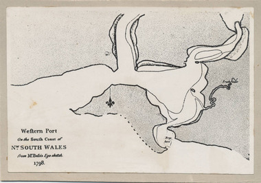 Phillip Island and District Historical Society Inc.
Photograph, Bryant West, 1798
... Phillip Island and District Historical Society Inc. phillip-island-and-the-bass-coast One of a collection of over 400 photographs in an album commenced in 1960 and presented to the Phillip Island & Westernport Historical Society by the Shire of Phillip Island local history photography photographs exploration maritime documents maps george bass phillip island bryant west john jenner As written on front of map - "Western Port on the South Coast of Nw. ...One of a collection of over 400 photographs in an album commenced in 1960 and presented to the Phillip Island & Westernport Historical Society by the Shire of Phillip IslandPhotograph of the First Map of Phillip Island ever drawn. An eye sketch by Bass.As written on front of map - "Western Port on the South Coast of Nw. South Wales from GE Bass's Eye-sketch 1798"local history, photography, photographs, exploration, maritime, documents, maps, george bass, phillip island, bryant west, john jenner -
Phillip Island and District Historical Society Inc.
Book, Western Port chronology 1798-1839 : exploration to settlement, 1984
... Phillip Island and District Historical Society Inc. phillip-island-and-the-bass-coast Extracts from log books and journals of explorers and travellers from the time George Bass entered and sketched the harbour in 1798, combined with rare charts and plates. This compilation brings life to European activity at Western Port during the thirty-seven years that preceded Melbourne's founding. xiv, 110 p. : ill., facsims., maps ; 24 cm. ...Extracts from log books and journals of explorers and travellers from the time George Bass entered and sketched the harbour in 1798, combined with rare charts and plates. This compilation brings life to European activity at Western Port during the thirty-seven years that preceded Melbourne's founding. xiv, 110 p. : ill., facsims., maps ; 24 cm. ISBN 0959065202 -
 Phillip Island and District Historical Society Inc.
book, Ruth Gooch, Seal Rocks and Victoria's primitive beginnings, 2008
... Phillip Island and District Historical Society Inc. phillip-island-and-the-bass-coast seal rocks local aboriginal history sealing western port Stamped Phillip Island & District Historical Society ix, 166 p. : ill., maps, ports. ; 25 cm. ...ix, 166 p. : ill., maps, ports. ; 25 cm. Includes index. Bibliography: p. 151-159. Stamped Phillip Island & District Historical Societyseal rocks, local aboriginal history, sealing, western port