Showing 2594 items
matching maps of victoria
-
 Warrnambool and District Historical Society Inc.
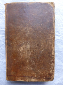
Book, The history of ancient Greece pub 1812, 1812
This book has the signature of Joseph Ware of Minjah, Caramut, Victoria. Joseph Ware came, with his parents, from England to Van Diemen’s Land (Tasmania) in 1822. With his brother, Jeremiah, he came to the Port Phillip Colony (Victoria) in 1838 and settled in the Colac area (Wooriwyrite and Koort-Koort-Nong stations). With his brothers or alone Joseph then held the runs of Minjah, Mustons Creek (Barwidgee), Sinclair West and Springburn. Joseph Ware was a highly successful pastoralist, breeding sheep, cattle and horses and importing Shorthorn cattle. Ware was connected with Minjah from 1845 to his death in 1895. The homestead at Minjah which still stands today was built by Joseph Ware in 1870. This book is of interest because of its antiquarian nature. But it is far more important because it was once the property of Joseph Ware. He and his brothers were most influential pastoralists in South Western Victoria in the 19th century. This is a hard cover book of 630 pages. It has a Preface, an Introduction, five Books with Chapters on the history of Greece and an Index. The cover is dark brown leather, now stained and mottled, with ‘Robertson’s Greece’ embossed in red and gold lettering on the spine. The top of the first page has been cut out and there is considerable staining throughout the book. There is one insert map of ancient Greece and some scribble (perhaps a signature) on the first and last pages. The inscription is handwritten in black ink. ‘Joseph Ware, Minjah, Caramut’ ‘Dec.24…’ ware brothers, joseph ware, minjah, pioneers of s.w. victoria -
 Warrnambool and District Historical Society Inc.
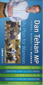
Document, Leaflet Federal Election, 2013
This is a 2013 election leaflet for Dan Tehan, the Federal Member for Wannon (Liberal Party). Wannon electorate is in the south west of Victoria and was one of the original seats established in 1900 for the first Federal Government. Warrnambool is in the Wannon Electorate. Dan Tehan won the seat in 2010 for the Liberal Party and has held it ever since. This is a leaflet of four pages and a cover. The printed material is multi-coloured with colour photographs, a map of the electorate and election statements and promises. There is one loose sheet printed in black and white. dan tehan, wannon electorate, warrnambool -
 Warrnambool and District Historical Society Inc.
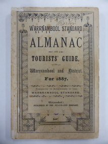
Book, Warrnambool Standard Almanac 1887, 1887
This booklet was given to subscribers to the Warrnambool Standard newspaper as an almanac for the year 1887. These Standard almanacs were produced from 1875 to 1930. They contain much local information on Warrnambool and district about the businesses, government officials, schools, societies and organizations, harbour management, churches, banks etc. The Warrnambool Standard newspaper was established in 1872 and continues to this day. This booklet is of high significance as it contains much valuable information on Warrnambool and district for the year 1887. It is a very important research tool for those studying and writing the history of Warrnambool and district. This copy has the name ‘Barber’ on the front cover and probably refers to George Barber, the son of George Barber, a well-known solicitor who opened a legal practice in Warrnambool in 1855. He died in 1879 and it appears that a member or members of his family went to live in the Maryborough district. This copy came into the collection of the Warrnambool and District Historical Society via the Midlands Historical Society. This is a soft cover booklet of 73 pages, plus several pages of advertisements. The section on the tourist’s guide to Warrnambool is printed in pink. There is a fold-out page with a map of the railway routes in Victoria. The cover is buff-coloured with black lettering and is slightly frayed. There is some scribble on the first page and the back cover. There are many black and white illustrations and several sketches of Warrnambool and district printed in pink. The name ‘Barber’ is handwritten in black ink on the front cover. ‘Barber’ ‘Miss Duff c/o Mrs Hyslop Farquar Lodge Lysle Street Ladysmith South Africa’warrnambool standard newspaper, history of warrnambool, standard almanac1887 -
 Kiewa Valley Historical Society
Folder - Bogong High Plains and Falls Creek, 1960's and 1970's
Tourism on the Bogong High Plains developed after/during the State Electricity Commission of Victoria construction of the Kiewa Hydro Electric Scheme.With the completion of the power stations on the Bogong High plains, tourism has created a new focus and different infrastructure/lifestyle for the community.A blue folder with a collection of papers & booklets on: 1. Discovery of Bogong High Plains 1962 2. SECV Discovery of Bogong High Plains 1968 3. SECV Kiewa Hydro Electric Scheme 1911 - 1961 4. Newspaper cutting - Mt Beauty 1974 5. McKay Creek Power Station and Clover Power Station 6. Falls Creek and Mt Beauty Tourist Map & brochures 7. Bogong High Plains Tour 1973bogong high plains; falls creek; tourism; -
 Kiewa Valley Historical Society
Report - Alpine Study Area Volume 2 Maps, Land Conservation Council, 1970s
The Victorian Environmental Assessment Council and the former Environment Conservation Council (ECC) and Land Conservation Council (LCC) have completed 36 land use investigations over more than 35 years, including 27 regional reviews. They provide a framework for use of Public Land in Victoria. The Land Conservation Council was established by the Land Conservation Act 1970.These maps provide an assessment of the Alpine area at the time the maps were created. Some of the topics eg. Rainfall and water resources may change over the years thus providing a comparative analysis. Others may provide information for future development such as mineral exploration, building of a dam / tunnel etc.Blue box shaped folder containing 9 of 10 Maps of the Alpine Study Area produced by the Land Conservation Council. Maps include 1. Public land and descriptive blocks. 2. Physiography. 3. Topography. 4. Geology (missing). 5. Rainfall and water resources. 6. Vegetation 7. Land systems. 8. Recreation. 9. Primary production. 10. Minerals Ex library item. Stamped in red "Discarded From Stock / Swan Hill Regional Libraryalpine area, maps of alpine area, land conservation council -
 Kiewa Valley Historical Society
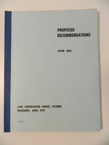
Report - Alpine Area Proposed Recommendations, Land Conservation Council, Victoria Melbourne, April 1978, April 1978
The Land Conservation Council was established by the Land Conservation Act 1970. It makes recommendations to the Minister for Conservation with respect to the use of public land. Notices showing the boundary of the study area ... published in the Victorian Government Gazette Sept. 1973. A descriptive report was published in July 1977. Submissions (1538) on the future use of public land were received & included those representing a wide cross-section of the community. These were considered in the final report.Of interest for research on the changing ideas regarding the use of public land and the environment.Blue book bound by dark blue cloth tape. It has 92 pages with maps at the end and an empty folder inside the back cover.alpine area, land conservation council, alpine study area report -
 Kiewa Valley Historical Society
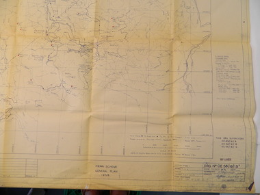
Plan - Kiewa Scheme General Plan 1958, S.E.C.V. Design & Construction Dept. Civil Branch, Dec. 1958
The Kiewa Hydro Electric Scheme was constructed by the State Electricity Commission of Victoria. Draftsmen drew up the plan of the layout as per the instructions from the engineers. The plan was drawn up on a transparency sheet and paper prints run off on a 'dyeline' copier. The 'Chief draftsman' and 'Design engineer' and 'Civil engineers recommended it and approved it. Historic: This plan gives a time line for the work on the Kiewa Hydro Electric Scheme. It is a good example of the work of a draftsman and the copying process in 1958.Large topography map of the area covered by the Kiewa Hydro Electric Scheme in 1958. Mountain peaks are marked in red and named. Rivers, roads, construction infrastructure as well as the main areas / names of construction are named. Signed and dated by employees of the S.E.C.V. working on the scheme.state electricity commission of victoria., kiewa hydro electric scheme, plan, engineer, draftsman -
 Kiewa Valley Historical Society
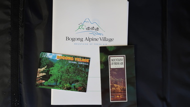
Papers - Bogong Village & the 'Commissioner's' Lodge & Progress Association Members, c 1997/1998
Bogong Village was built by the SECV in 1940 for the workers of the Kiewa Hydro Electric Scheme. In 1971, 30 houses were furnished for use as holiday homes for SEC personnel throughout the State. From 1989 to 1993 the houses were restored & renovated.During the 1990s the buildings in the village had been leased to private owners. Many of them rented their houses for tourists. The Commissioner's lodge was on the other side of the Mt Beauty - Falls Creek road, above Bogong Village. Wally Baldwin ran it in the 1960's.It was destroyed by the 2003 bushfires.These papers present a history of 'the Commissioner's lodge' and Bogong Village in the 1990's. The Progress Association was an active community group in 1963/64.Papers advertising Bogong Village & the Lodge for accommodation with rates 1997/1998. Describes the alternatives, maps and cafe hours, Also, 'Jan's Recollections' and on the back of these pages a hand written list of members of the the Progress Association 1963-64 as 'per Mr A. McCullough's spiel'. In original folder and includes a pamphlet & postcard.bogong village, secv lodge, lake guy, state electricity commission of victoria., kiewa hydro electric scheme, tourism, accommodation -
 Kiewa Valley Historical Society
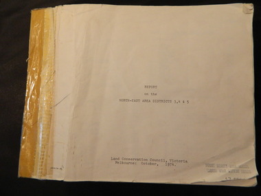
Report - Land Conservation Council x2, Land Conservation Council, Victoria Melbourne, April 1978, October 1974
Land Conservation Act 1970 established the Land Conservation Council to investigate and recommend to the Minister use of public land in Victoria. It describes and assesses the natural resources:-Physiography, Geology, Topography, Land Systems, Outdoor Recreation, Public land and blocks. Primary Production. Vegetation.North East Victoria includes the Kiewa Valley. This report gives an understanding of the development of the area.Thick heavy book with 312 pages with black and white photos. Back half has a folder with heavy cardboard attached to thick cardboard back cover. Inside folder are 9 maps with color each with a different title.Stamped on Front Cover: "Mount Beauty High School" Has a library borrowing slip at the back of the last page.land conservation council, environment, public land, kiewa valley, planning -
 Kiewa Valley Historical Society
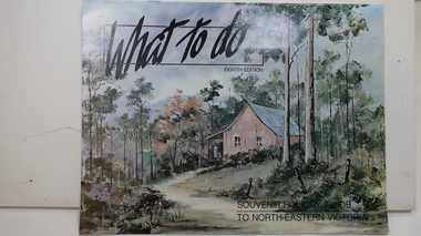
Brochure - Tourism, What to do - Souvenir Holiday Guide to North-Eastern Victoria
The Kiewa Valley has promoted itself as a tourist hot spot since the Kiewa Hydro Electric Scheme concluded. Mt Beauty began as a construction town and was to be sold off but tourism became promising so the SECV handed the town over to the Bright Shire, houses were sold and businesses commenced. From the early 1960s the town promoted itself and Falls Creek as a tourist destination. The Kiewa Valley Accommodation group combined with the local advertisers to publish this brochure.This brochure promotes tourism all year round promoting the local businesses enabling them to succeed. As tourism is the main industry in Mt Beauty and Falls Creek since the Kiewa Hydro Electric Scheme finished, this advertising is important. It is interesting to note the businesses - their type, their location and the comparison with those in the area now.19 black and white pages including maps and advertisements. Cover is a 'washed' color of a hut in the bush. The title is in black across the top and at the bottom right hand corner. The front cover is in 'landscape' format but the rest of the book is 'portrait'.mt beauty; falls creek; kiewa valley; tourism; north east victoria -
 Kiewa Valley Historical Society
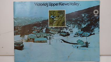
Booklet - SEC x2, 1. Victoria's Kiewa Valley 2. Victoria's Upper Kiewa Valley, No. 2 is dated October 1978
The State Electricity Commission of Victoria built the Kiewa Hydro Electric Scheme and was keen to promote tourism in the area. The booklet includes Facilities, Falls Creek Ski Resort, the Kiewa Works Area, the Three Floras of Bogong, the Geology of the Kiewa area, the Bird and Animal life of Bogong and the Kiewa Hydro Electric Scheme. The colored photos and the map on the back appeal to the reader/tourist.The SECV promoted tourism in the Kiewa Valley especially the area of the Kiewa Hydro Electric Scheme. This booklet is attractive and informative with a lot of detail. This proved to be the early stages of tourism in the area in what is now a very popular tourist destination and the main industry for the Upper Kiewa Valley.Blue cover with photo of Falls Creek at night. Title in black print at the centre top under which is an insert photo of a blue wren and SEC logo in white towards the top far right. Back cover is light green with a tourist map of the area. The text is complimented with brightly colored photos throughout.state electricity commission of victoria; kiewa hydro electric scheme; tourism; bogong; flora; fauna; geology; -
 Kiewa Valley Historical Society
Leaflet - Kiewa, Welcome to Kiewa
The State Electricity Commission of Victoria constructed the Kiewa Hydro Electric Scheme from 1938 to 1961. The Scheme included three power stations, dams, tunnels and was becoming a popular tourist destination with Falls Creek Ski field within its boundaries.This leaflet was published by the SECV to ensure all visitors to the Kiewa Hydro Electric Scheme were made aware of safety measures with regard to their driving and to bush fires. These were necessary as the area was unique with driving on mountainous roads, changeable and extreme weather and the threat of bush fires. The gatehouse existed during construction, when the SECV was in charge, as a restriction to entry to the Scheme for SECV workers and those with permission to enter. The SECV controlled the area so in case of accident, the SECV was the body to contact not eg. the police.Small white and green leaflet made from one sheet of glossy paper and folded in half. Front cover has the title in the middle, the SECV emblem at the centre top and across the bottom is a message to read the inside pages which are safety messages for driving and bush fires. The back cover has a RACV road map of Kiewa and its 'works' including the Gatehouse which was the entrance to the scheme.The map also has an insert of the main roads & nearby cities. state electricity commission of victoria; kiewa hydro electric scheme; gatehouse; safety rules; kiewa -
 Kiewa Valley Historical Society
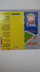
Brochure - Falls Creek Tourism, Falls Creek Never Out of Season
Falls Creek is a Ski Resort in the north east of Victoria. This brochure has been produced to encourage tourists to visit throughout the year.Tourism to the Kiewa Valley is an important industry for the area. Falls Creek is a ski resort with accommodation during winter for skiers, snow boarders and other snow sports. It involves entertainment, restaurants and associated workers. This brochure is produced to promote the resort throughout the year to increase the occupancy of these lodges. The tourist industry has increased steadily with fishing, cycling and bush walking increasing numbers in the area.Glossy square brochure folded in in half and half again. Front page is yellow on the left with black print on the far left. The right side has the title with blue, green and grey background with yellow, orange and white as part of the title. The back is a man standing in front of a sunset with print in a column towards the right side. Inside includes a map with advertisements for accommodation surrounding it.falls creek ski resort; alpine region in victoria; mountain lodges; -
 Kiewa Valley Historical Society
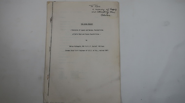
Memoir - Adrian Rufenacht, The Kiewa Project
Adrian Rufenacht, BCE (S.F.I.T. Zurich) MIE Aust. former Chief Civil Engineer of the State Electricity Commission of Victoria, retired 1967. Insight into the Kiewa Hydro Electric Scheme.First hand knowledge of the history of the Kewa Hydro Electric Scheme.40 pages stapled with 4 staples. The Kiewa Hydro Electric Scheme by Adrian Rufenacht, former civil engineer of SECV. Includes maps.On the front page - handwritten: 'To Ron / in memory of happy / and interesting times. / Adrianadrian rufenacht, khes, kiewa project, construction, secv -
 Kiewa Valley Historical Society
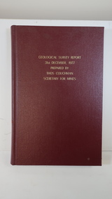
Book - Geographical Survey, Geographical Survey Report 31st Dec. 1977 prepared by Thos. Couchman Secretary for Mines
Office of Mines published progressive reports on the Geological Survey of parts of Victoria.This book includes a chapter on 'Dargo and Bogong' Pages 96 - 117 and includes a fold out map of this area. These pages show heavy use.Hard deep red cover with gold printed title located at the centre top. Bound with spine blank. 217 pages. Date 1878 First chapter and some pages have pencil marks including page 97.geological survey 1878, dargo, bogong -
 Kiewa Valley Historical Society
Maps - Tawonga and Feathertop
Plan of Tawonga showing roads etc, rivers, use of land in 1968 and of Feathertop in 1969.Historical use of land in Tawonga and Feathertop.1. Topographical Map - Tawonga 803 Forests Commission of Victoria 1968. Cream paper with black print. Legend: Roads, tracks etc, rivers, Parishes and use of land. 2. Feathertop 813. 1969tawonga map 1968, tawonga parishes, feathertop map 1969 -
 Kiewa Valley Historical Society
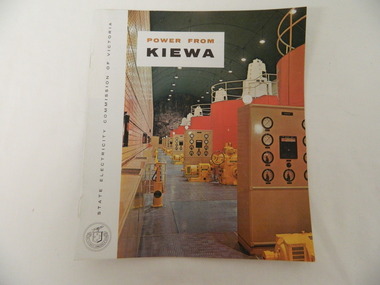
Booklet - S.E.C.V. x2, Power from Kiewa
The State Electricity Commission of Victoria constructed the Kiewa Hydro Electric Scheme. Their public relations employees published booklets to promote the Scheme and the area. In this booklet there are photos of some of the major work constructions with an explanation of how they work and their purpose, a map of the Scheme and an article and photos of tourist facilities and activities that are available.This booklet promotes the Kiewa Hydro Electric Scheme and tourism indicating that tourism was recognised as a new industry for the area. The photos give a pictorial history of the area eg. skiing using the Summit T-bar lift and includes the facilities available at the time. The explanation of the Kiewa Hydro Electric Scheme is a basic resource for students interested in Hydro power.Slim booklet with photo of McKay Creek Power Station on the front cover and the title in brown and black at the top. Printed along the spine is State Electricity Commission of Victoria.state electricity commission of victoria. kiewa hydro electric scheme. tourism. t-bar ski tow. falls creek -
 Kiewa Valley Historical Society
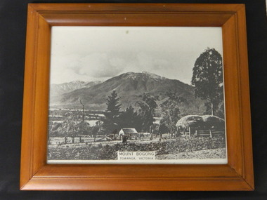
Photo - Mt Bogong, Towanga, Possibly early 1900s
Towanga & Mt Bogong. Mt Bogong is actually the mountain on the left at the back. Early maps spelt Tawonga differently to the current day spelling 'Tawonga'. The haystack and fence indicate that the photo may have been taken at the turn of the century. The exotic trees are not very old.This seems to be an early photo of Tawonga showing older style fencing and haystack and vegetation in the area.Black and white photo with title at the bottom middle - "Mt Bogong / Towanga (sic), Victoria Modern light brown wooden frame with black cardboard back triangular hook and black cardboard stand attached. Photo covered with clear glass.Sticker on back of frame "67480 Eng Walnut / 49426 / Made In Thailandtowanga. tawonga. mt bogong. kiewa valley. -
 Kiewa Valley Historical Society
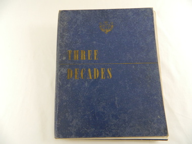
Book - Historical - SECV x3, Three Decades. The Story of the State Electricity Commission of Victoria from its Inception to December 1948, First Published March 1949
At the time of writing this book The State Electricity Commission of Victoria had been in existence for 30 years. This book tells something of its progress and achievements during that period. It includes brown coal and water power. The Commission was to develop and use these natural resources through the expertise and experience of the Commissioners, its staff and employees. Historical: Chapter 5 "The War Years - and Kiewa." describes the early stages of the Kiewa Hydro Electric Scheme. Photos, map and diagrams of the Kiewa Scheme are also included. Hard cover blue bound book with the SECV insignia and the title "Three Decades" both in gold on the front cover. Book includes coloured and black and white photos.Handwritten inside front cover: "Bob Burnett". Title page: hand written in print and crossed out: "L.D.Miller / Tawonga". Not crossed out - "(Cheryl)"state electricity commission of victoria. kiewa hydro electric scheme. bogong high plains. pretty valley. kiewa valley. -
 Kiewa Valley Historical Society
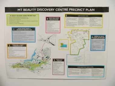
Poster - Mt Beauty Discovery Centre Precinct Plan
The current (2015) Mt Beauty Tourist Centre site was to be upgraded into a 'Sports Tourism Cluster' with funding from the Government and the Alpine Shire with 'In Kind' assistance from Falls Creek Resort management Board, Parks Victoria and the Local Community & Tourism Industry. This project didn't go ahead.The Mt Beauty town was handed over to the Alpine Shire in the 1960's after completion of the Kiewa Hydro Electric Scheme. Plans for up dating facilities are on-going but are rarely completed. This poster is an example of this.Very large laminated poster depicting 6 points for the Alpine Region Sports Tourism Cluster. Each point has a coloured border and background to black writing. There are 3 maps.mt beauty. tourism. discovery centre. sports cluster. -
 Kiewa Valley Historical Society
Map - Topographical, Ski Club of Victoria Bogong High Plains and Adjacent Peaks, Early 1930's
This map has been in the Ryder family for approx. 70 years. Probably used when bush walking and skiing in the early days on the Bogong High Plains. The Ryder family are farmers in the Kiewa Valley and were involved in taking their cattle up to the Bogong High Plains where they had a lease. The State Electricity Commission of Victoria constructed the Kiewa Hydro Electric Scheme opening up the area during the 1940's and 1950's. This type of map is an early one, used by people in the Kiewa Valley and possibly by surveyors prior to construction.The map is an early topographic map used by farmers living in the Kiewa Valley. It is historically significant as these people were involved in taking cattle up to the High Plains during summer and may have been used for bush walking and skiing.This is a sepia coloured paper map which was originally printed copyright registered. It was revised in 20/6.33/4.4.37/8.4.40/24.8.43/19/6/54. It shows roads / tracks / snow poles / snow pole numbers (27) / Snow pole spacing (3 chains. 66 yards) approximately 27 poles to the mile / height above sea level in feet - 5280. Water courses not definitely located etc.Rocky Valley Dam (Kiewa Hydro Electric Scheme) has been drawn on the map by hand with a biro. There is a wooden rod at the top of the map.topographic map; kiewa valley; ryder family; high plains of victoria -
 Kiewa Valley Historical Society
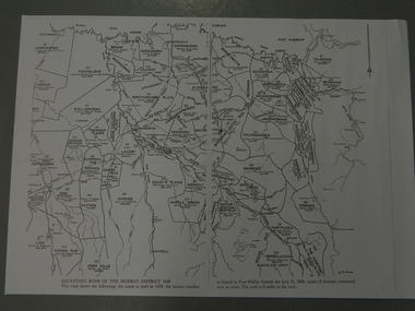
Maps - Squatting Runs of the Murray District 1848 x2, July 26,1848
The Port Phillip Gazette was the second newspaper published in Melbourne, in the then Port Phillip district, now Victoria. In 1948 it was published bi-weekly.The map shows the original names of squatters along the Kiewa River. The names of the district are mostly current today although some are spelt differently.2 copies - 1 laminated & 1 paper of the map of "Squatting Runs of the Murray District 1848." The area is recorded (eg. Tawanga, Dederang, Gundowring, Kergunia, Merrimarenbung all along the Kiewa River) under which the names of the squatter is recorded, the number of acres and the licence number. Scale is 8 miles to the inch.squatting runs; kiewa valley; port phillip district; -
 Warrnambool and District Historical Society Inc.
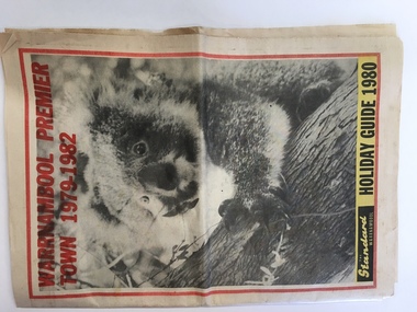
News Sheet, Standard, 1980
This Holiday Guide was produced by the Warrnambool Standard with several articles contributed to the supplement by Sally Clark, the Warrnambool Tourist Promotion Officer. Holiday Guides were produced each year to assist and promote tourism in the area. The fact that Warrnambool had won the Premier Town Award for the years 1979-1982 was an added reason for tourists to come to the region and this fact was used as an advertising tool. Warrnambool won the Premier Town Award in 1988 for the third time. This Holiday Guide is of some interest as it shows what was considered the best places for tourists to visit in the Warrnambool region in 1980. The advertisements are also of some value for recording the business life of the city in 1980. This is a 40 page Holiday Guide published by the Warrnambool Standard newspaper in 1980 featuring tourist spots of Warrnambool and district. It includes black and white photographs, maps and advertisements. ‘Warrnambool Premier Town,1979-1982, The Standard, Warrnambool, Holiday Guide 1980’premier town awards, victoria, warrnambool -
 Warrnambool and District Historical Society Inc.
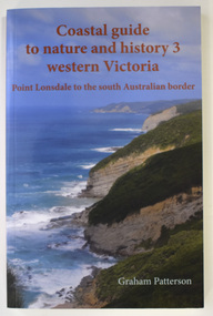
Book - Coastal Western Victoria, Graham Patterson, Coastal Guide to Nature and History 3 Western Victoria, 2022
Description of Western Victorian Coast from Point Lonsdale to South Australian BorderThis is a book of 188 pages. The cover has colour photographs and printing in red and white. The pages contain printed text, maps and illustrations, and black and white and colour photographsnon-fictionDescription of Western Victorian Coast from Point Lonsdale to South Australian Borderwestern victoria coastline, graham patterson, warrnambool, shipwreck coast -
 Warrnambool and District Historical Society Inc.
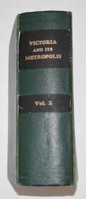
Book, Victoria and its Metropolis Vol 2, 1888
... coloured maps. Victoria and its Metropolis Vol 2 Book ...Information on the of Colony of VictoriaThe book has a green cloth cover with an indented pattern. The spine has gold printing on black cloth attached to the green cloth. The 820 pages are gilt edged and, to some extent, are water damaged. They contain printed text and lithographs .Some original pages relating to Warrnambool have been removed and replaced with photocopies which are pasted in. There are fold out coloured maps.non-fictionInformation on the of Colony of Victoria warrnambool history, history of victoria -
 Warrnambool and District Historical Society Inc.
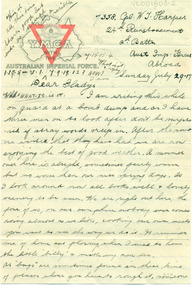
Document, Letters: July 1917 To Gladys from 7358 Pte William Thomas Harper, pre 1917
Original documents, envelopes, diet sheet,letters and photograph sent from abroad from William Thomas harper to Gladys Holmes, Byaduk 7358 Pte William Thomas Harper b. 1896, Byaduk, 8th Battalion - 24th Reinforcements, embarked on 19th February 1917 on HMAT A70 Ballarat. Killed in France on 3rd May 1918. Buried Outtersteene Communal Cemetery Extension, Bailleul France. Cousin to twin AV Harper and RS Harper. one of eight correspondents to Gladys Holmes, ByadukOriginal documents, part of 14 sets of correspondence to Gladys Holmes and local Byaduk residents from local servicemen during WW 1..001803.1: Envelope 001803.2 -.6R: Buff coloured paper, 6 sheets with YMCA logo on map of Australia and red triangle. 001803.7 - 7R: Envelope has a red 1d stamp with 20 SEP 17 black ink postmark and blue ink handwritten address with sender's details. 001803.8 - 8R: note and Diet sheet Week Aug 26 - Sep 2 1917 001803.9 - 9R: Small sepia photograph of physical training soldier, and reverse has handwritten notes001803.1: Envelope, addressed to Miss Gladys Holmes/Byaduk/Hamilton/Victoria/Australia. Postmark ...CAMP B.O. SALISBURY 10 UY 17 001803.2-.6R: Leeter: 24th Reinforcement/2nd Battn/Aust Imp Forces/Abroad/Sunday July 29.17 to Dear Gladys 001803.7- 7R: Envelope: Red id stamp with black postmark 11.45AM, 20 SEP 17, Address-Miss Gladys Holmes/Byaduk/Hamilton/Victoria/Australia. Sender: 7538 8th Batt. Reverse: Received 24th Nov 1917. 18.8.17/Use old/address/still/ 24.8 A.I.F. etc 001803.8- 8R: Note andDIET SHEET Week Aug 26 to Sep 2, Breakfast Dinner & Tea 1001803.9 - 9R: Photograph of physical trainer and reverse has 11 lines of informationwilliam thomas harper, gladys holmes, byaduk ww1, letter, photograph, envelope, a.i.f. -
 Warrnambool and District Historical Society Inc.
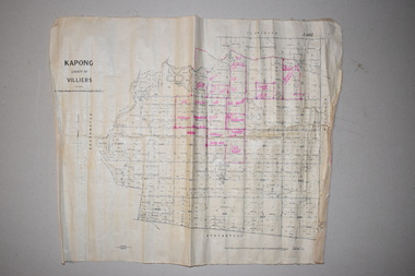
Maps (2), 1 Kapong .2 Hawkesdale, 1 1913 .2 1942
These two maps of the Kapong/ Hawkesdale area in Victoria show the original lands that belonged to the pioneer settler, Charles Hamilton MacKnight and the handwritten annotations that show the subsequent owners of these lands. Charles Hamilton Macknight (1819-1873) came to Australia from Scotland in 1841 and in 1842, with partners, James Irvine and William Campbell, established the property of Dunmore in Broadwater (24 kilometres from Hawkesdale). He was a prominent breeder of sheep, cattle and horses. Sections of his lands were acquired by the Baulch family and these maps were acquired from a member of the Baulch family, with Stanley Baulch being the possible annotator of the Kapong map. These maps are of interest as they show the properties that belonged to the pioneer settler, Charles Hamilton MacKnight and the subsequent division of these lands, some of these passing into the hands of the Baulch family. As the Kapong map also shows other original landowners, it will be a useful tool for researchers..1 This is a map of Kapong in the County of Villiers. It is on a rectangular-shaped piece of linen-backed paper with black printing and some handwritten annotations in red ink. It is crumpled at the edges. .2 This is a rectangular-shaped piece of paper showing a map of the Hawkesdale area. The printed material is in grid form in black, green and red. At the left bottom edge it has a mauve stamp. kapong, victoria, hawkesdale, victoria, dunmore estate, victoria, charles hamilton macknight, baulch family, western victoria, history of warrnambool -
 Warrnambool and District Historical Society Inc.
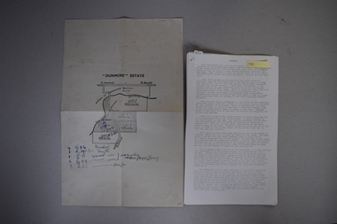
Map and Article, Dunmore, 1 1954 .2 1970
Both these items deal with the property of Dunmore, in the Macarthur/Hawkesdale/ Woolsthorpe area of Western Victoria. The first item is a sheet of paper with a map and details of the sale of portion of Dunmore in 1954. This is an original document. The second item is a history written by Stan Baulch of the property Dunmore from its establishment up to 1970. Dunmore was first established by Charles Hamilton MacKnight and two partners in 1842 and it was purchased by Samuel Baulch in 1893. After Samuel Baulch’s death the property was bequeathed to his three sons. One son, Stanley Baulch (1897-1980) took over the eastern portion which he named Rose Park. Stan Baulch was a member of the Warrnambool and District Historical Society and wrote several articles on aspects of his life and work, including this valuable article on the history of Dunmore. These items are of significance as they concern the estate of Dunmore in Western Victoria, an early and important property which is still farming land today under various owners. .1 This is a sheet of paper containing a map of the Dunmore property on one side and details of the sale of portion of Dunmore on the other side. The map has been annotated in handwritten black ink. The page has been folded twice. .2 This is an article typed on 12 foolscap pages. The typing is somewhat faint in places. ‘Dunmore’ Estate Dunmore baulch family, western district, victoria, dunmore estate, macarthur/hawkesdale, history of warrnambool -
 Warrnambool and District Historical Society Inc.
Original Document, Map: Agricultural area of Ballangeich 1865, 1865
... surveys Victoria 1865 Lands Act 1865 Victoria Ballangeich map 1865 ...George Eddington arrived in Australia in 1839 and named and established property in 1841 calling the property Ballangeich after a Pass near his home town of Stirling in Scotland. It is situated 151 miles west of Melbourne and to the south of Mortlake and was originally part of the Mortlake shire, which was proclaimed 26th Jan 1864. Nearest streams are the Hopkins Riverand Lyall and Drysdale creek running through good agricultural land. This map relates to the breaking up of large runs which the Victorian government enabled through selection acts of the 1860's. The previously larger runs which were mainly cattle and sheep based were now more open to closer settlement and a greater variety in farming.The lots range in size from approximately 50 acres to around 600 acres.Some areas are set aside for reserves. By 1886 the population of Ballangeich had grown to around 600 with an hotel, three state schools and a church.Tri weekly coaches ran to Colac, Warrnambool and Camperdown providing access to supplies mail and communication. This map is typical of many which were produced in the 1860's in Victoria during a significant period of Victoria's and Warrnambool district history.Rectangular light card paper with black text showing allotments of land The area is coloured in green with scale at bottom right cornerAt the top: Plan of the Agricultural area of Ballangeich 1865 At the bottom left: Prepared by the Board of Lands & Works in accordance with the Amending Land Act 1865 Lands & Survey Office Melbourne 13th April 1865. With signaturehistory of warrnambool, ballangeich, land surveys victoria 1865, lands act 1865 victoria, ballangeich map 1865 -
 Warrnambool and District Historical Society Inc.
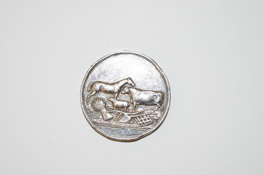
Medal, Villers & Heytesbury, 1879
This splendid medal was awarded by the Villiers and Heytesbury Agricultural Association in 1879. This association held its first show in Port Fairy in 1854 and in Warrnambool in 1855. It continues to this day under the name of the Warrnambool and District Agricultural Society. The medal was awarded to James Astley Bromfield, am early Warrnambool chemist who arrived in Victoria in 1852 and is significant in Warrnambool’s history. He produced the 1856 map of the Warrnambool district with the first landowners, a seminal resource for historians and was prominent in community affairs, especially in horse racing. He was also a Warrnambool and Shire Councillor. The medal was awarded for the best blood yearling of 1879 and this was Fright, one of the progeny of the famous stud horse Panic (second in the Melbourne Cup, 1865), His progeny won many hurdle races and flat races including the Melbourne Cup. The medal features also the names of two donors of prizes to James Bromfield, Henry Phillips and Francis Tozer, both pioneer men in Warrnambool’s horse racing history. Henry Phillips was the first President of the Warrnambool Amateur Turf Club and had the horse Panic standing at his 1000 acre stud, Bryan O’Lynn, at Purnim in the Western District. Francis Tozer was an owner, breeder and steward in racing circles and in the 1870s had the 2000 acre stud farm, Wangoom Park, at Wangoom, near Warrnambool.This is a most significant item as it was awarded to James Astley Bromfield, an early Warrnambool chemist and a person concerned with the history of the early settlement of Warrnambool and one prominent in community affairs in Warrnambool in the 19th century. The item also has connections with the famous stud horse, Panic and two other noted personalities of Warrnambool and district, Francis Tozer and Henry Phillips. The item also is of intrinsic monetary value as a 19th century medal from the Villiers and Heytesbury Agricultural Association. This is a round silver medal. It has etched printing on one side and raised images of farm animals and farm implements on the other side. It also has etched printing around the edge of the medal. There are some slight dents around the edge of the medal.‘Villiers & Heytesbury Agricultural Association 1st Prize Awarded to J. A. Bromfield for Blood Yearling 1879 ‘Fright by Panic’ Warrnambool Oct. 16 1879’ ‘Also Phillips and Tozer’s Special Prizes’ james astley bromfield, warrnambool, villiers and heytesbury agricultural association, henry phillips, warrnambool, francis tozer, warrnambool, history of warrnambool