Showing 167 items
matching south road brighton
-
 City of Moorabbin Historical Society (Operating the Box Cottage Museum)
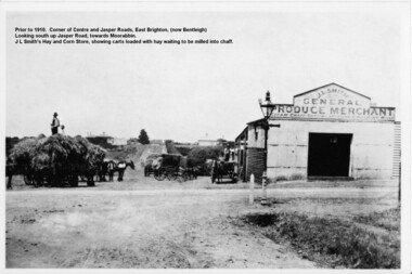
Photograph - Photograph Hay & Corn Store, Before 1910, Smith's Hay & Corn Store, Cnr. Centre and Jasper Roads, Bentleigh, Late 19th to early 20th Century
The first photograph was taken prior to 1910. The location is at the corner of Centre and Jasper Roads, East Brighton, (now known as Bentleigh). It is an early view of John L. and "Minnie" Smith's Hay and Corn Store, situated on the South West corner of those two roads. The first photo was taken prior to the introduction of electricity in the area. A gas lamp and horse "hitching post" can be seen "in shot". There are several loaded wagons waiting in line to have their hay milled to chaff. Farmers came from places as distant as Carrum to have their loads of hay milled into chaff. John Smith was born in 1860 in Point Nepean Road, Brighton, and Minnie was born in Patterson Road, Moorabbin, in a wattle and daub cottage with earthen floor and butter muslin over the windows. The couple married in 1884, Minnie was a devout Methodist and the family became very involved in the development of the local Methodist church. The couple had four children and during the 1890s Depression their first child died, they lost all their possessions, and John's family struggled to survive. Finally in the late 1890s JL Smith was able to rent a shed from Mr Henry Box on the corner of Centre and Jasper Roads, and he later purchased that property. With the gradual improvement in the economy, and the development of the successful market gardening industry in the Shire of Moorabbin, JL Smith's produce store became quite prosperous. Over some years the little "shed" developed into a thriving Hay and Corn Store. JL Smith went on to become Moorabbin Shire President in 1914. He and his wife were active in assisting soldiers returning injured from the 1st WW, in the local Methodist Church and other early community projects. Smith was a typical example of the majority of the early settlers in the Shire of Moorabbin, being god-fearing and devoted to the idea of service to the community. The photographs demonstrate the primitive conditions and early development of what is now a bustling and well-recognised area of Bentleigh, (known as east Brighton before 1907). The photo shows a gas lamp in use before the introduction of electricity in 1916. The Smith's story is representative of the many early pioneering traders, who elected to "set up shop", who suffered the adversity of the 1890s depression, but who survived and made their living in the largely undeveloped area of East Brighton ( now Bentleigh) district. Two black and white early photographs both of the same location. The photos are of the corner of Centre and Jasper Roads, Bentleigh. (Prior to 1907 this area was known as East Brighton.) Both photos show J.L Smith's General Merchant Produce store. "Steam Chaff Cutting and Corn Crushing Mills" and the surrounding area at differing stages. In the first photo taken prior to 1910, we can see there are several horse-drawn carts loaded with hay waiting to be milled, a gas lamp and a horse "hitching post". The store is just a single unadorned, shed. The later, second photo of the same area, shows improvements and the further development of that site. On the back of the photo "Hay and Corn Store -/ not later than 1910."/"Photographer /Victor C Smith,/ Phone Number XL1472"/hitching post, methodist church, smith minnie, moorabbin shire president, gas lamp, east brighton district, 1890s depression, wattle and daub cottage, centre road, jasper road, box henry, smith john l -
 City of Moorabbin Historical Society (Operating the Box Cottage Museum)
Photograph - Map of Dendy's Special Survey, 1852 Map of Henry Dendy's Special Survey of 1841, 19th Century
A Map drawn in 1852 that shows the 5,120 acres that formed Dendy's Special Survey of 1841. In 1840 Henry Dendy, a farmer in Surrey, England acquired a "Special Survey" from the Commissioners for Land and Emigration which gave Dendy the right to choose land in Port Phillip for the "bargain basement" price of only £1 per acre for 5120 acres, (an area of 8 square miles). The Special Survey also included the right to "the shipment of a worker for every £20 spent on land, whose free passage was paid by the Crown, equalling a total of 100 workers ". Accordingly Dendy sold his English holdings and paid the required £5120 and arrived in Melbourne in February 1841. However by this time land in the new colony was selling for £5 - £40 per acre. Because Henry Dendy possessed the order from the Colonial Office in London he was able to successfully oppose Governor LaTrobe's attempts to alter the price of the land. Dendy appointed Jonathan Were, (an entrepreneur, who had arrived in 1839), as his Manager and who later became a partner. Together, Dendy and Were decided on an area 5 miles south from Melbourne, bounded by North Road, East Boundary Road, South Road and to the west by Port Phillip Bay. Were and Dendy pitched their tents in the area now known as ' Park St, Brighton' and sank a well near the corner of 'St Andrew's St and Wells St'. By 1845 J.B Were and Company had bought almost half of Dendy's land and Were built himself "Moorabbin House" in Were St Brighton made from stone, quarried from local cliffs. It was still standing in 1924. Legend records Moorabbin is named after the Aboriginal word for ' Mother's Milk ' The soil is very fertile and well supplied with water especially in the area called 'East Brighton' - now known as Bentleigh and East Bentleigh - By 1850 the area had developed with numerous market gardens, dairy farms, fruit gardens and vineyards supplying food for the growing population of Melbourne.This Map shows the birth of the Brighton and Moorabbin area. On 18th January1859 Brighton was proclaimed a Municipality and a Borough by October 1863. Meanwhile, following a Petition, the area of East and South Brighton, incorporating Mordialloc, Cheltenham, Mentone, Sandringham and Oakleigh separated from Brighton to form the Moorabbin District Roads Board becoming the first Local Government Authority. Col. William Mair was elected as the first Chairman of the Moorabbin Roads Board. Moorabbin Shire 1871 developed further and was declared a City in1934. The City of Moorabbin was the largest Municipality in Melbourne before the Amalgamation of Councils in 1994 when it was divided in the south to City of Kingston and in the north to City of Glen Eira A Photo-lithographed 1852 Map showing the 5,120 acres that formed Dendy's Special Survey of 1841. Henry Dendy & Jonathan Were chose an area 5 miles south from Melbourne, bounded by North Road, East Boundary Road, South Road and to the west by Port Phillip Bay. Moorabbin County of Bourke / Photo-Lithographed at the department of Lands and Survey. /Melbourne. / Price 1/- brighton, moorabbin, bentleigh, cheltenham, dendy henry, bent thomas, were jonathan, special survey -
 City of Moorabbin Historical Society (Operating the Box Cottage Museum)
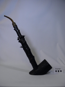
Leisure object - Pipe, South African smoking, Circa 1900
This item was donated to the Moorabbin Historical Society in the 1980's by Mr John Herron of Bentleigh. It was brought back from the Boer War by Private W.F. Daff of South Brighton [Later Moorabbin] Private Daff served in the Second Contingent sent to the Boer War 1899 - 1902 South Africa.This item is of Historical Significance because it is linked to the Boer War [1899- 1902] and is of native South African origin.Mr John Herron is a descendant of James Jones an early settler in Moorabbin Shire and the Daff family were early settlers in South Brighton ( Moorabbin).A large natual wood pipe in three pieces with carved bone mouth piece.The bottom piece is on an angle so it stands upright. A hole is bored through the middle of the pipe at different sizes so the smoke is drawn up through the pipe slowly by the smoker.The carvings around the join for the top section of the pipe are very fine and delicate and extend up an over the join to camouflage it.boer war, daff w.f., pipe, native, moorabbin, brighton, south africa, bentleigh, herron john -
 City of Moorabbin Historical Society (Operating the Box Cottage Museum)
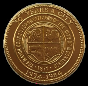
Badge - City of Moorabbin - 50 Years Medal, 1984-85
A gold-plated medal issued by the City of Moorabbin to commemorate the quincentenary of Victoria in 1984-5. It features the City Shield incorporating vegetables, a rooster, a cow and a house, and the sesquicentenary logo. The township of Moorabbin, known as South Brighton until 1909, remained small, with the Plough and Harrow Hotel as its main building. In 1917 Sandringham borough was formed by severance from Moorabbin shire and in 1920 Mentone and Mordialloc were also severed. In the remaining Moorabbin shire the Moorabbin township was still small (1,770 persons), but the shire grew in population during the 1930s. On 10 October 1934 it was proclaimed a city. It existed as a separate municipality until 1995. When local government boundaries were changed in 1994 about half of Moorabbin city was united with Glen Eira city and about half with Kingston city. On 15 December, 1994 the City of Chelsea, parts of the Cities of Mordialloc, Moorabbin, Springvale and Oakleigh were amalgamated to create the City of Kingston by Order of the Governor in Council. On the same day Glen Eira City Council was formed from the City of Caulfield and the remaining part of the City of Moorabbin.Gold Plated Medal Side one: Within a wide rim formed by a line circle, the City Shield incorporating vegetables, a rooster, a cow and a house; around, THE MAYOR COUNCILLORS & CITIZENS OF THE CITY OF MOORABBIN; around on broad rim, 50 YEARS A CITY 1934 - 1984. Side 2: Logo of the Victorian sesquicentenary; below, VICTORIA 150 / GROWING TOGETHER 1984-5 at rim in small letters the mint name, BRIM MELBTHE MAYOR COUNCILLORS & CITIZENS OF THE CITY OF MOORABBIN; VICTORIA 150 / GROWING TOGETHER 1984-5.city of moorabbin, victorian sesquincentenary, moorabbin shire, councillors moorabbin, cheltenham, bentleigh, moorabbin, le page family, cr coates l.r, cr sheppard l.a., cr cooper j.c. -
 City of Moorabbin Historical Society (Operating the Box Cottage Museum)
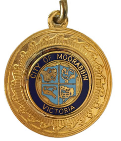
Badge - City of Moorabbin Key Chain
“City of Moorabbin” The township of Moorabbin, known as South Brighton until 1909, remained small, with the Plough and Harrow Hotel as its main building. In 1917 Sandringham borough was formed by severance from Moorabbin shire and in 1920 Mentone and Mordialloc were also severed. In the remaining Moorabbin shire the Moorabbin township was still small (1,770 persons), but the shire grew in population during the 1930s. On 10 October 1934 it was proclaimed a city. It existed as a separate municipality until 1995. When local government boundaries were changed in 1994 about half of Moorabbin city was united with Glen Eira city and about half with Kingston city. On 15 December, 1994 the City of Chelsea, parts of the Cities of Mordialloc, Moorabbin, Springvale and Oakleigh were amalgamated to create the City of Kingston by Order of the Governor in Council. On the same day Glen Eira City Council was formed from the City of Caulfield and the remaining part of the City of Moorabbin.Gold Key ring with a dark blue circle surrounding the shield of the City of Moorabbin.City of Moorabbin, Victoria,city of moorabbin -
 City of Moorabbin Historical Society (Operating the Box Cottage Museum)
Programme - Two Programs for Mayoral Functions held in the City of Moorabbin. 1946 & 1953, City of Moorabbin Council, 1946 & 1953
“City of Moorabbin” The township of Moorabbin, known as South Brighton until 1909, remained small, with the Plough and Harrow Hotel as its main building. In 1917 Sandringham borough was formed by severance from Moorabbin shire and in 1920 Mentone and Mordialloc were also severed. In the remaining Moorabbin shire the Moorabbin township was still small (1,770 persons), but the shire grew in population during the 1930s. On 10 October 1934 it was proclaimed a city. It existed as a separate municipality until 1995. When local government boundaries were changed in 1994 about half of Moorabbin city was united with Glen Eira city and about half with Kingston city. On 15 December, 1994 the City of Chelsea, parts of the Cities of Mordialloc, Moorabbin, Springvale and Oakleigh were amalgamated to create the City of Kingston by Order of the Governor in Council. On the same day Glen Eira City Council was formed from the City of Caulfield and the remaining part of the City of Moorabbin.Official functions held in the City of Moorabbin 1946 & 1953Two program cards, one green 1946 and the other cream 1953. The inside lists the entertainment during the reception of the Mayoral functions of the City of Moorabbina) RECEPTION /given by the / MAYOR AND MAYORESS / of MOORABBIN / 1946 b) RECEPTION / given by the / MAYORESS of MOORABBIN / 1953mcc, marriott, ward, coates, city of moorabbin, reception, program cards, entertainment, market gardeners, early settlers, cheltenham, moorabbin, bentleigh -
 St Kilda Historical Society
Postcard, Brighton Rd (south west)
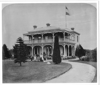
Photo shows two adults and four children with croquet sticks in hand in front of building black and white photograph, unmounted, copy, good conditionOn back: Brighton Road, w side Built for Emil Thoneman, Merchant. Demolished approx 1960. Flats now on the site in Wimbledon Avenue -
 St Kilda Historical Society
Photograph, St Kilda (Brighton Road)Primary School
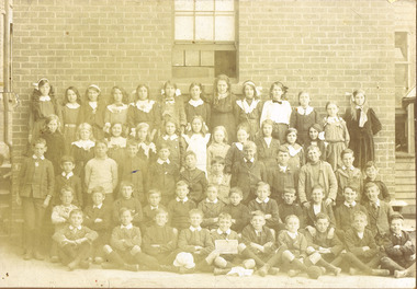
Unable to read date in photograph but children's clothing suggests early 1900ssepia photograph mounted fair conditionSt Kilda (Brighton Road)Primary School. (?) Thomeson (?). 721 South Road, Moorabbin. Donated to the Historical Society. -
 Kingston Arts
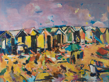
Painting, Elizabeth Prior, Summer Brighton, 1982
-
 Ballarat Tramway Museum
Photograph - Digital image, Dick Jones, W3 661 outbound in St Kilda Road, Dec. 1964
Demonstrates one of the Museum's trams in service in Melbourne.Digital Image of MMTB tram W3 661 outbound in St Kilda Road, approaching Doman Junction. Tram has destination of East Brighton, Route 64 and an advertisement for Proofkote (rain wear protection?) BP House in the background. Photo December 1964. Photo reference from Dick Jones - 661_StKildaRd_DickJones_6412MIns.23.04trams, tramways, w3 class, st kilda road, east brighton, tram 661 -
 Ballarat Tramway Museum
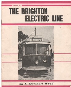
Book, Leon Marshall -Wood, "The Brighton Electric Line", 1956, 1958
.1 - Twenty page booklet on the history of the Brighton Electric Line by Leon Marshall-Wood, published 1956. Gives a brief history of the electric tramway operated by the Victorian Railways between St. Kilda Station and the Brighton Beach railway station, that commenced operation in 1905. The booklet was priced 2/-, published by the Traction Publications. Has 18 photographs, map 1905 and present day (when printed), rolling stock roster and notes and on the rear cover has details of the AETA. Front cover has horizontal crimson stripes. Has details of the AETA on the back cover and listing of some publications. Second copy from Ian Stanley added 24-1-2016. .2 - as for above - second edition, 1958, similar text, different photo layout and different front cover photo. See Reg Item 7631i for a scan of the 1966 edition.On front cover of first copy of .1 - top right hand corner; "N.Z.R.L.S / with compliments" and initials. Under title of book, "Price to Society 18/- Aust. per doz. / Retails 2/-" On page 3 of second copy of .1 - "Ian J Stanley 28 Park Road, South Camberwell, SE6, BK3746" On page 3 of .2 - "Ian J Stanley" in ink.trams, tramways, vr, melbourne, brighton, st kilda -
 Ballarat Tramway Museum
Ephemera - Timetable/s, Melbourne and Metropolitan Tramways Board (MMTB), Set of 24 MMTB Melbourne tram timetables, 1969
Set of 24 MMTB timetables for various routes, dated July 1969. Generally includes Sat and Suns, Good Friday and Christmas day as well as weekdays, unless noted otherwise. Also includes a map of the route, detailed time points, sections, connecting services, fares, and organisation address - 616 Little Collins St. Melbourne. Have been folded into ten portions. All on white paper unless noted otherwise. Items shown with an # - have a sticker modifying timetable information details on the front page. 1154.1 - Route 4 - Carnegie - City .2 - Route 4D - East Malvern (Darling Road) - City # .3 - Route 5 - Malvern Burk Road, - City # .4 - Route 6 - Glen Iris - City # .5 - Route 7 - Camberwell - City # .6 - Route 8 - Toorak - City # .7 - Routes 9, 10 and 12 - South Melbourne and St Kilda Beach - City (Brunswick St.) - via Collins St. .8 - Routes 10, 11 - West Preston and routes 9 & 9A Northcote .9 - Routes 15 & 22 - Moreland and 1 & 21 - East Coburg .10 - Route - 15 & 16 - St Kilda Beach and 1 & 2A - South Melbourne Beach - via Swanston St. .11 - Route 19 - North Coburg - City # .12 - Route 42 - Mont Albert - City # .13 - Routes 48 - North Balwyn and Burwood - City .14 - as above, but for Saturdays and Sundays on pink paper .15 - Routes 55 & 56, West Coburg - City - (William St.) - Domain Road. .16 - Route 57 - West Maribyrnong - City .17 - Route 59 - Essendon (Aerodrome) - City .18 - Route 64 & 65 - East Brighton - City .19 - Route 69 - Kew Cotham Road - St. Kilda Beach # .20 - Route 70 - Wattle Park - City # .21 - Routes 77 - Prahran - City, 78 - North Richmond - Prahran, 79 - North Richmond - St Kilda Beach .22 - Route 82 - Footscray to Moonee Ponds .23 - Route 88 - East Preston - City and Route 96, East Brunswick - City .24 - as above but for Saturdays and Sundays on pink paper. Images of a sample of documents added 16-11-2013.mmtb, timetables, melbourne -
 Ballarat Tramway Museum
Photograph - B&W print of donated negative, Ron E. Fluck, 7/04/1950 12:00:00 AM
Black and white print of a donated negative. Print made 8/1998. Photo of Victorian Railway tram No.34 at the Brighton Beach terminus. Tram has the destination of "St Kilda Rly Stn". In the overhead can be seen the pan for assisting the driver to put the rear pole onto the wire. Also in the background of the photo is a stone wall of the railway tunnel under the road that served the Brighton Beach Pier. Photo taken 7-4-1950. See Victorian Railways to '62, pages 47 and 49 re railway tunnel.tramways, trams, brighton beach, vr, railway tunnel, tram 34 -
 Bayside Gallery - Bayside City Council Art & Heritage Collection
Map, H.B. Foot, Plan of the Brighton Estate containing 5120 acres, first special survey at Port Phillip, c. 1842
This plan records the Brighton Estate, also known as Dendy's Special Survey. In 1840 Henry Dendy, a farmer in Surrey, England acquired a "Special Survey" from the Commissioners for Land and Emigration which gave him the right to choose land in Port Phillip for the low price of £1 per acre for 5120 acres. Dendy appointed Jonathan Binns Were, as his agent, who later became a partner. Together, Dendy and Were decided on an area 5 miles south from Melbourne, bounded by North Road, East Boundary Road, South Road and to the west by Port Phillip Bay. Their Brighton Estate was first surveyed by T. S. Townsend in May 1841 and was re-surveyed by Robert Hoddle. Dendy and Were were making plans to sell the land and advertised a 30-guinea prize for the best subdivision which was to be divided into a village, marine residences, suburban and cultivation allotments, with the remainder being divided into country sections. The competition was won by H.B. Foot, who planned the village around a reserve and crescents and a 'green belt' forming the town boundary. brighton estate, dendy's special survey, special survey, henry dendy, jonathan binns were, w.b. were, survey, plan, map, brighton, george ward cole, baker's lithographer, hibernian, subdivision, town planning, cartographic material, h.b. foot -
 Bayside Gallery - Bayside City Council Art & Heritage Collection
Map, Department of Crown Lands and Survey et al, Moorabbin, County of Bourke, Government Roads, 1920
The cadastral map of the Parish of Moorabbin in Victoria (L.6104) shows parish boundaries and land ownership 1920 when Sandringham was a Town. The government roads have been coloured in red pencil.moorabbin, county of bourke, map, plan, land subdivision, land titles, foreshores, hampton, beaumaris, highett, cheltenham, department of lands and survey, land owners, cartographic material, brighton, sandringham, town of sandringham, government roads -
 Bayside Gallery - Bayside City Council Art & Heritage Collection
Photograph, Department of Crown Lands and Survey, Victoria, Melbourne Project: Brighton, Hampton, Sandringham, 1976
The Department of Crown Lands and Survey (1857-1983) was responsible for the administration of survey and mapping and the sale, occupation and management of crown land throughout its existence. This aerial photograph shows parts of Brighton, Hampton and Sandringham and was taken on 1 December 1976brighton, department of crown lands and survey, aerial photograph, bayside, port phillip bay, map, cartographic material, hampton, sandringham, green point, sandringham yacht club, south road, beach road, hampton street, melbourne project 1976 -
 Bayside Gallery - Bayside City Council Art & Heritage Collection
Photograph, Department of Crown Lands and Survey, Victoria, Melbourne Project: Brighton and Hampton, 1976
... Hampton Green Point Brighton Beach South Road The Esplanade ...The Department of Crown Lands and Survey (1857-1983) was responsible for the administration of survey and mapping and the sale, occupation and management of crown land throughout its existence. This aerial photograph shows parts of Brighton and Hampton and was taken on 1 December 1976. brighton, department of crown lands and survey, aerial photograph, bayside, port phillip bay, map, cartographic material, melbourne project 1976, brighton yacht club, middle brighton baths, hampton, green point, brighton beach, south road, the esplanade, hampton street -
 Bayside Gallery - Bayside City Council Art & Heritage Collection
Photograph, Department of Crown Lands and Survey, Victoria, Brighton, Brighton East and Bentleigh, c. 1965-71
... Centre Road nepean highway South Road Football Black and white ...The Department of Crown Lands and Survey (1857-1983) was responsible for the administration of survey and mapping and the sale, occupation and management of crown land throughout its existence. This aerial photograph shows parts of Brighton, Brighton East and Bentleigh and was taken circa 1965-71.brighton, department of crown lands and survey, aerial photograph, bayside, port phillip bay, map, cartographic material, bentleigh, brighton east, dendy park, dendy street, centre road, nepean highway, south road, football -
 Bayside Gallery - Bayside City Council Art & Heritage Collection
Photograph - gelatin silver photograph, Visit of His Royal Highness the Prince of Wales to the Municipality of Brighton, 1920
In 1920 the Prince of Wales embarked on a journey to Australia on behalf of his father, King George V. While the visit was intended to strengthen the relationship between Australia and the Empire, the main objective was to offer thanks to the Australian men and women for the sacrifices and contributions that they had made during World War I. The Royal Tour began in April 1920 and covered 110 cities and towns across the country. The Prince spent eleven days in New South Wales, nine days in Victoria, four days in Tasmania, eleven days in Western Australia, six days in South Australia and eight days in Queensland. On Saturday 5 June 1920, following a morning at the races in Flemington, the Prince spent the afternoon at ANZAC Hostel in Brighton, where he chatted to wounded soldiers and, according to the newspaper reports at the time, "won the hearts of all present."prince of wales, his royal highness, hrh, royal tour, anzac hostel, brighton, mayor, cr. thomas wilson, j.h. taylor, town clerk, soldiers, diggers, crowd, guard of honour, captain grieve, h.m.s. renown, north road, kamesborough, bayside -
 Bayside Gallery - Bayside City Council Art & Heritage Collection
Photograph - gelatin silver photograph, Visit of His Royal Highness the Prince of Wales to Brighton, 1920
In 1920 the Prince of Wales embarked on a journey to Australia on behalf of his father, King George V. While the visit was intended to strengthen the relationship between Australia and the Empire, the main objective was to offer thanks to the Australian men and women for the sacrifices and contributions that they had made during World War I. The Royal Tour began in April 1920 and covered 110 cities and towns across the country. The Prince spent eleven days in New South Wales, nine days in Victoria, four days in Tasmania, eleven days in Western Australia, six days in South Australia and eight days in Queensland. On Saturday 5 June 1920, following a morning at the races in Flemington, the Prince spent the afternoon at ANZAC Hostel in Brighton, where he chatted to wounded soldiers and, according to the newspaper reports at the time, "won the hearts of all present."prince of wales, his royal highness, hrh, royal tour, anzac hostel, brighton, mayor, cr. thomas wilson, j.h. taylor, town clerk, soldiers, diggers, crowd, north road, kamesborough, bayside -
 Bayside Gallery - Bayside City Council Art & Heritage Collection
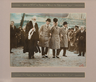
Photograph - hand tinted gelatin silver photograph, H. Singer, The Prince and party at The Anzac Hostel, Brighton, 1920
In 1920 the Prince of Wales embarked on a journey to Australia on behalf of his father, King George V. While the visit was intended to strengthen the relationship between Australia and the Empire, the main objective was to offer thanks to the Australian men and women for the sacrifices and contributions that they had made during World War I. The Royal Tour began in April 1920 and covered 110 cities and towns across the country. The Prince spent eleven days in New South Wales, nine days in Victoria, four days in Tasmania, eleven days in Western Australia, six days in South Australia and eight days in Queensland. On Saturday 5 June 1920, following a morning at the races in Flemington, the Prince spent the afternoon at ANZAC Hostel in Brighton, where he chatted to wounded soldiers and, according to the newspaper reports at the time, "won the hearts of all present."prince of wales, his royal highness, hrh, royal tour, anzac hostel, brighton, mayor, cr. thomas wilson, soldiers, diggers, crowd, north road, kamesborough, bayside -
 Bayside Gallery - Bayside City Council Art & Heritage Collection
Map, Department of Crown Lands and Survey, Moorabbin, County of Bourke, c. 1918
The cadastral map of the Parish of Moorabbin in Victoria (L.6104) shows parish boundaries and land ownership c. 1918 when Sandringham was a Borough.moorabbin, county of bourke, map, plan, land subdivision, land titles, foreshores, sndringham, hampton, beaumaris, highett, cheltenham, department of lands and survey, land owners, cartographic material, borough of sandringham, brighton -
 Ballarat Tramway Museum
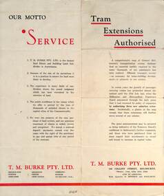
Pamphlet - Real Estate, T M Burke Pty Ltd, "Tram Extensions Authorised", 1936
Wal Jack collected tramway and railway items for his collection. This pamphlet gives details of the Melbourne Public Transport system - rail, tram and bus in late 1936. Issued by T M Burke Pty Ltd of 840 Collins St Melbourne, Real Estate agents, shows the extensive sub-divisions where land was available for purchase and notes the MMTB authorisation of new tram routes. Gives details of the T M Burke services. Routes shown as authorised (16-7-1936) are: Keilor Road Essendon, High St North Balwyn and Hawthorn Road East Brighton. Demonstrates a Real Estate Sales pamphlet.Pamphlet - four colours printed on cream coloured bond paper, folded vertically originally.letter, wal jack, buninyong, railway lines -
 Kew Historical Society Inc
Plan, Melbourne & Metropolitan Board of Works : Contour Plan of Melbourne & Suburbs : Melbourne Sewage, 1894
The Melbourne and Metropolitan Board of Works (MMBW) plans were produced from the 1890s to the 1950s. They were crucial to the design and development of Melbourne's sewerage and drainage system. This plan forms part of a large group of MMBW plans and maps that was donated to the Society by the Mr Poulter, City Engineer of the City of Kew in 1989. Within this collection, thirty-five hand-coloured plans, backed with linen, are of statewide significance as they include annotations that provide details of construction materials used in buildings in the first decade of the 20th century as well as additional information about land ownership and usage. The copies in the Public Record Office Victoria and the State Library of Victoria are monochrome versions which do not denote building materials so that the maps in this collection are invaluable and unique tools for researchers and heritage consultants. A number of the plans are not held in the collection of the State Library of Victoria so they have the additional attribute of rarity.Digital copy of an original MMBW plan. This contour plan shows the area identified by the MMBW for purposes of drainage and sewerage in 1894. The suburbs represented extend from Williamstown in the west to Bulleen in the east, and from Preston in the north, south to Sandringham. Suburbs are outlined in coloured ink. Red lines indicate main and branch sewers in existence at the beginning of 1894 in central and inner Melbourne. These extended as far as Williamstown and Brighton, but not yet as far as Kew, where sewering did not commence until 1901. Contour lines show the topography, which was important for indicating the fall of the land for the laying of sewers and drainage channels. Kew appears to be fairly undeveloped at this date except for railway lines and stations (the Kew and Outer Circle lines), main roads, the Kew Lunatic Asylum Reserve and Studley Park. However, the contour plan does not accurately represent the density of settlement, nor the large number of houses, which were being built in Kew and other suburbs from the 1850s to the land boom of the late 1880’s and early 1890’s. This plan is part of a large and historically significant group of MMBW plans and maps that was donated to the Society by the Mr Poulter, City Engineer of the City of Kew in 1989.mmbw contour plan of melbourne and suburbs, melbourne and metropolitan board of works, melbourne sewage, cartography -
 Kew Historical Society Inc
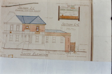
Slide - Architectural Drawing, Kew Public Offices, 1887
A civic campaign for new public offices developed in Kew in the 1880s. After much deliberation, the location chosen was the junction of Bulleen and Cotham Roads. The buildings were designed by George Watson and John Henry Harvey, architects within the Department of Public Works (Victoria). Building was commenced in 1887, and after one year, the buildings were opened. The Post Office was transferred to the new Commonwealth Government in 1901. The Police Station and Court House, sold by the Victorian Government to the City of Boroondara in 2007, are now a community cultural centre and performing arts venue.The buildings were listed on the Victorian Heritage Register Register (HO885) in 1991. They are historically and architecturally significant to the State Of Victoria because Watson and Harvey's designs exhibit diversity in integrating civil offices, they accommodate the apex of road junctions, and they demonstrate a departure from the contemporaneously favoured High Victorian Classical to the Queen Anne style in the design of civic buildings. 35mm colour transparency of an original plan by George Watson and John Henry Harvey, architects of the Department of Public Works (Victoria), in 1887 for New Public Offices at Kew. This plan was copied by the donor from an original held at the Commonwealth Archives in Brighton (Vic). The copy was made to illustrate a report that the donor made on ‘The functional planning design, building materials and construction methods of the Kew Post Office’ as part of course work at RMIT.SOUTH ELEVATION / SECTION L-L / SECTION G-Gkew court house, kew police station, kew post office, architectural drawings, khs - slides, new public offices -- kew (vic.), architecture — queen anne style -
 Glen Eira City Council History and Heritage Collection
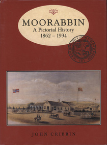
Book, "Moorabbin: A Pictorial History, 1862 - 1994", 1995
Copy of pictorial history book written by John Cribbin significantly signed by councillors and the author on the first page.The words "Moorabbin: A Pictorial History, 1862 - 1994" printed in brown colour in and oval at the top of a red, hard paper cover book, copy of an image of horse and carts and Gregg's Plough and Harrow Hotel, South Brighton below. Below that name of author "John Cribbin" is printed. -
 Glen Eira City Council History and Heritage Collection
Document (Item) - Newspaper (digital), Caulfield Contact
The Caulfield Contact was the official newspaper of the City of Caulfield from 1976-1994. The City of Caulfield was the Municipal Council for an area of the South Eastern suburbs of Melbourne, including Brighton East, Carnegie, Caulfield, Elsternwick, Gardenvale, Glen Huntly, McKinnon, Murrumbeena, Ormond and St Kilda East. Following the amalgamation of City of Caulfield and parts of the City of Moorabbin in 1994, the municipality was renamed the City of Glen Eira. The Caulfield Contact was replaced by the Glen Eira News. 320-001-1976-001-001-07-28 Vol 1 edition 1 July 1976 Twenty-fifth (25th) anniversary of home help service; Profiles on Councillors Ray Mann, David Nolan; Murray and Wells call out for historical material; Resident's proposal for ward boundary changes accepted by Council, Profiles Councillor Bert Caldwell, Stan Hunter Town Hall Reprieve, History of Caulfield First Caulfield Arbor Day, Results of Council Elections held on 26 August 1976 city of caulfield, caulfield, history of caulfield, glen eira -
Glen Eira City Council History and Heritage Collection
Document (Item) - Newspaper (digital), Caulfield Contact
The Caulfield Contact was the official newspaper of the City of Caulfield from 1976-1994. The City of Caulfield was the Municipal Council for an area of the South Eastern suburbs of Melbourne, including Brighton East, Carnegie, Caulfield, Elsternwick, Gardenvale, Glen Huntly, McKinnon, Murrumbeena, Ormond and St Kilda East. Following Amalgamation of City of Caulfield and parts of the City of Moorabbin in 1994, the Caulfield Contact was followed by the Glen Eira News. Includes references to the following: Children's Neighbourhood Centre Caulfield; Fire destroyed Caulfield Park Bowling Club; Naming of Harleston Park; Home Handyman Service; Profiles Councillors Peter Baitz, Ron Walters; Carnegie-Glenhuntly Football Club formed Council drops approval of rail crossings over Neerim and Glenhuntly Roads; Profiles Councillor Alwyn Samuel, Glen Richards; First stage of Nepean Highway widening; Minister approved re-subdivision; Council spills; Exciting development of Caulfield Park; Profiles Councillor Max Blair, Councillor Brian Rudzki; Tram shelter classified by National Trustcity of caulfield, caulfield, glen eira, city of glen eira, caulfield contact, children's neighbourhood centre caulfield, fire destroyed caulfield park bowling club, naming of harleston park, home handyman service, profiles councillors peter baitz, ron walters, carnegie-glenhuntly football club formed, council drops approval of rail crossings over neerim and glenhuntly roads, profiles councillor alwyn samuel, glen richards, first stage of nepean highway widening, minister approved re-subdivision, council spills, exciting development of caulfield park, profiles councillor max blair, councillor brian rudzki, tram shelter classified by national trust -
Glen Eira City Council History and Heritage Collection
Document (Item) - Newspaper (digital), Caulfield Contact
The Caulfield Contact was the official newspaper of the City of Caulfield from 1976-1994. The City of Caulfield was the Municipal Council for an area of the South Eastern suburbs of Melbourne, including Brighton East, Carnegie, Caulfield, Elsternwick, Gardenvale, Glen Huntly, McKinnon, Murrumbeena, Ormond and St Kilda East. Following Amalgamation of City of Caulfield and parts of the City of Moorabbin in 1994, the Caulfield Contact was followed by the Glen Eira News. Contains References to the following Freedom of Entry to 3rd ordinance of the RAAOC, visit by Sir Zelman Cowen, Return to Rosstown, A 'spacy new home' (nursery at Caulfield Park), Profile on Gus Theobold, Meals on Wheels Aviary completed Caulfield Park. Profile resident Gus Theobold. Cr Irene Capek win Herald Australia Day essay prize. Caulfields Meals on Wheels set Victorian record. Historical feature Return to Rosstown. New ambulance station Glenhuntly and Clarinda roads opens. Volume 4 Number 5 Date 03 August 1978 Features Where and How to Vote in council election. Cr Irene Capek retires from council. Profiles election candidates. Image: Image Cr Irene Capek. Images of election candidates. Volume 5 Number 1 Date 14 September 1978 Freedom of Entry to 3rd ordinance of the RAAOC, visit by Sir Zelman Cowen, Subjects from Carol: GG Sir Zelman Cowen and Lady Cowen offical visit. Off street carpark project underway Pyne St and Hawthorn Rd. City Manager Graeme Caldwell submits plans for Townhall renovations. Action plan for development of Elsternwich Shopping precint to be developed. Freedom of Entry ceremony. Profile Rosemary Keppel. Booran Motors Glenhuntly donate dual control Holden Gemini to Caulfield Tech school pre-driver education program. council election results. Comments from elected Crs Jack Campell, Bob Baxter, Dorothy Ford, Brian Rudzki. Promotion of Caulfield Institute of Technology and TAFE. Image: Image Sir Zelman Cowen, Lady Cowen. Images Freedom of Entry ceremony and citizens attending. Image Rosemary Keppel. Cartoon pre-driver education program. Image Mayor Cr Geoff Patience in robes. Volume 5 Number 2 Date 26 October 1978 Rate rise 5.73% announced. Readership of Caulfield Contact surveyed. Caulfield ranger Reg Dixon and members of works dept rescue duck family from drain and reinstate them to Caulfield Racecourse dam. Profile resident and teacher Claire Manning. Image: Image of Reg Dixon and the rescued ducks. Image Claire Manning and students at Waverley Private school. city of caulfield, caulfield, glen eira, city of glen eira, caulfield contact, freedom of entry to 3rd ordinance of the raaoc, visit by sir zelman cowen, return to rosstown, a 'spacy new home' (nursery at caulfield park), profile on gus theobold, meals on wheels -
Glen Eira City Council History and Heritage Collection
Document (Item) - Newspaper (digital), Caulfield Contact
The Caulfield Contact was the official newspaper of the City of Caulfield from 1976-1994. The City of Caulfield was the Municipal Council for an area of the South Eastern suburbs of Melbourne, including Brighton East, Carnegie, Caulfield, Elsternwick, Gardenvale, Glen Huntly, McKinnon, Murrumbeena, Ormond and St Kilda East. Following Amalgamation of City of Caulfield and parts of the City of Moorabbin in 1994, the Caulfield Contact was followed by the Glen Eira News.city of caulfield, caulfield, glen eira, city of glen eira, caulfield contact