Showing 302 items
matching the proclaimers
-
 City of Greater Bendigo - Civic Collection
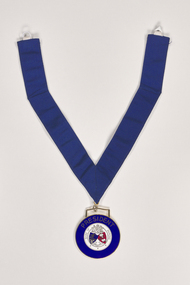
Ceremonial object - Shire of Marong President Medallion, P Blashki & Sons
The first local government authority for Marong was the Marong Road District (an early form of single-purpose local government), which was proclaimed on 19 August 1860. Its boundary was altered twice in 1862 and on 12 December 1864 it was re designated as a shire. It absorbed Raywood Borough in 1915, and was proclaimed a Rural City in 1990. On 2 December 1994, with the creation of Greater Bendigo City Council, it was abolished by being amalgamated with Bendigo City, Eaglehawk Borough, Huntly Shire, part of McIvor Shire, part of Metcalfe Shire and Strathfieldsaye Shire to form Greater Bendigo City.Manufactured by Blashki and Son this circular medal hangs from a royal blue gosgrain ribbon. The medallion has a gold edging with blue enamel outer band. Centre depicts Australia coat of arms and the Shire of Marong coat of arms.PRESIDENT / SHIRE OF MARONG / DIEU ET MON DROIT / INDUSTRIAshire of marong, marong presidents medal, city of greater bendigo ceremonial item -
 City of Greater Bendigo - Civic Collection
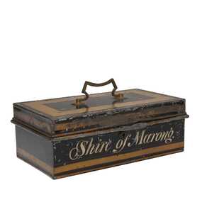
Functional object, Shire of Marong, Unknown
The first local government authority for Marong was the Marong Road District (an early form of single-purpose local government), which was proclaimed on 19 August 1860. Its boundary was altered twice in 1862 and on 12 December 1864 it was re designated as a shire. It absorbed Raywood Borough in 1915, and was proclaimed a Rural City in 1990. On 2 December 1994, with the creation of Greater Bendigo City Council, it was abolished by being amalgamated with Bendigo City, Eaglehawk Borough, Huntly Shire, part of McIvor Shire, part of Metcalfe Shire and Strathfieldsaye Shire to form Greater Bendigo City.Painted metal tin with handle on top. Currently locked closed.Shire of Marongshire of marong -
 Federation University Historical Collection
Map, Town of Buninyong, 1927, 09/1927
The date of this map is September 1927 revised from the original 1910 map. Buninyong was created a district on 09 July 1858, proclaimed a Shire on 16 February 1864, and the Buninyong Borough united on 01 October 1915.Township plan of the Town of Buninyong showing government roads and crown allotments. Earlier detail pencilled on (commercial buildings, etc) appears to be from an 1850 survey. Scale: 4 chains to 1 inch (1:3168)buninyong, map, buninyong botanical gardens, tannery dam, buninyong reservoir, chapel school, rev. hastie -
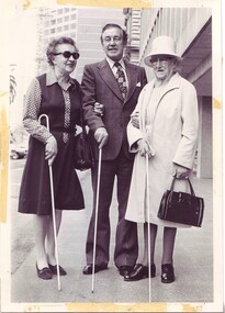 Vision Australia
Image, 15/10/1979
Sir Rupert Hamer, who proclaimed October 15 as White Cane Day for the State of Victoria, holding a white cane and standing between two blind ladies. The one on the right is possibly Mrs Alice McClelland.1 B/W photographwhite cane day, sir rupert hamer -
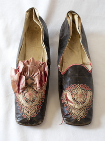 Brighton Historical Society
Shoes, circa 1867
These shoes were worn by Emily Cock (nee Smith), the daughter of wealthy early settler John Matthew Smith. From 1856 until 1931 the Smiths lived at 'Castlefield', a mansion on a vast estate that at one time stretched along South Road from Bluff Road to Hampton Street. The land was gradually subdivided, and the house is now a part of Haileybury College. Julien Mayer was a French ladies shoemaker and prolific exporter who advertised his successes on the shoes themselves by stamping the soles with details of the prizes he had won.Pair of black kid leather shoes with low block heel, decorated with pink silk, cut-away applique and embroidery. Pink bow with metal clasp on one shoe; missing from the other. Edged with pink silk ribbon binding, largely deteriorated.Sole embossed with "MAYER / Julien / à Paris", in addition to tamped with three small medallions proclaiming the awards the shoemaker won in London in 1862, Porto in 1865 and Paris in 1867. Handwritten in interior sole of T0124.2 in pencil: "Emily Smith / Castlefield"emily smith, castlefield, shoes, 1860s, applique, embroidery, julien mayer -
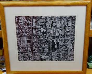 Kew Historical Society Inc
Photograph - Aerial View of East Kew, c.1930
The Municipality of Kew was proclaimed in 1860. This eastern section of Kew was settled from the 1850s with all land sold in the vicinity by 1851. The original large estates were further subdivided in the second half of the 19th and in the first decades of the 20th centuries.Early aerial photograph of KewFramed aerial photograph of that part of Kew in which is located Genazzano FCJ, the Kew Reservoir, and the retail nurseries of Bennett’s and Rimington's.genazzano fcj, kew reservoir, rimington's nurseries, bennett's nursery, cotham road, mont victor road (kew) -
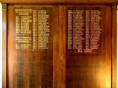 Sunshine and District Historical Society Incorporated
Honour Board, CHAIRMEN of BRAYBROOK ROAD DISTRICT 1860-1871 and PRESIDENTS of SHIRE OF BRAYBROOK 1871-1950, Unveiled 15 March 1940
By around circa 1850 Braybrook was already well established, and during the gold rush period also became a staging point for prospectors on their way to the diggings. Local government for the area began on 28th May 1860 when the BRAYBROOK ROAD BOARD DISTRICT was proclaimed, however this authority was soon superseded on 23rd January 1871 when the SHIRE OF BRAYBROOK came into existence. The Shire of Braybrook continued as the local government authority for the district until the CITY OF SUNSHINE was proclaimed in 1951. This Honour Board was unveiled on Monday 18th March 1940 at 8:30 p.m., and was hung in the Council Chamber, at the Shire of Braybrook Hall, Sunshine.The Honour Board is a historical record of the people who served as heads of local government in the district from 1860 to 1950.Large brown stained wooden structure comprised of two board sections positioned side by side to make one display board. Contains in gold coloured lettering the names of people who served as CHAIRMEN of the BRAYBROOK ROAD DISTRICT and as PRESIDENTS of the SHIRE OF BRAYBROOK during the years 1860 to 1950.braybrook road district, shire of braybrook, chairmen, presidents, 28 may 1860, 23 january 1871, 1950, sunshine., braybrook road district, shire of braybrook, chairmen, presidents, 28 may 1860, 23 january 1871, 1950, sunshine. -
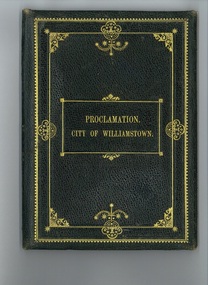 Hobsons Bay City Council
Proclamation of City of Williamstown, Circa 1919
Williamstown was first incorporated as a borough on 14 March 1856. It became a town on 2 April 1886, subdivided into four wards in 28 October 1887 and was proclaimed a city on 17 May 1919. The city was proclaimed by His Excellency the State Governor, the Hon. Sir Arthur Stanley on 17 May 1919. At the same time he unveiled a photographic honour board in memory of local soldiers killed during World War One and officially opened the Town Hall/Council Chambers building at 104 Ferguson Street. The Governor was presented with this proclamation and asked to sign the parchment. The official birth of the city was celebrated by 2000 residents. Commemorates the movement of Williamstown to the status of a city and also marks the occasion of the opening of the new municipal buildings, Council Chamber and unveiling of a collective photo of local soldiers who had died during WW1.Bound Proclamation of City of Williamstown signed by Governor of State Victoria. 3rd April 1919, black tooled leather with gilt embossing, two fold with ribbon from date of visit - 17th May 1919Arnall & Jackson, Melb Proclamation City of Williamstowncouncil chambers, williamstown, -
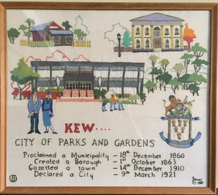 Kew Historical Society Inc
Textile - Bicentennial tapestry, 8. Kew. City of Parks and Gardens, 1988
This is one of eight embroidered panels, completed during the 1988 Australian Bi-Centennial, and carried out under the auspices of City of Kew Council and the Kew Historical Society. Nearly 600 residents, including many children, participated in their production by adding a few or more stitches. A book records their names and the panels upon which they worked. Artist: Joy Stewart / Co-ordinator: Dorothy Benyei.8. Kew. City of Parks and Gardens. A framed embroidery created by adults and children of the City of Kew as a Bicentennial project, based on a design by the artist Joy Stewart. Five of the six completed embroideries created in the project are/were displayed in the Kew Library. [The five embroidered panels have now been temporarily removed for conservation reasons].Inscription: "KEW: City of Parks and Gardens / Proclaimed a Municipality December 1860 / Created a Borough 1st October 1863 / Gazetted a Town 14th December 1910 / Declared a City 9th March 1921." Embroidered signature of the artist: "(c) JStewart, 1988"bicentennial project (kew), joy stewart, charles grimes expedition, australian bicentennial -
 Bendigo Historical Society Inc.
Document - NOTED EVENTS, c1970
Document. Two pages typed, timelined document on noted events in the Bendigo District, 1839 - 1891. Prepared by the Bendigo Branch of the Royal Historical Society of Victoria. Mentions Mr Charles Sherratt, Grice and Heape (licenced squatters of Mt. Alexander sheep run, later called Ravenswood), Mrs John Kennedy & Mrs Patrick P Farrell. 'Bendigo's Creek' named after Thomas Myer, Mr J A Paton (Resident Commissioner), Mr Lachlan McLachlan (Police Magistrate), First Bendigo Advertiser printed 9 Dec. 1853, Bendigo 1854 Census - 15,480 and 4,000 Chinese, E. J. Ennor, Sandhurst Fire Brigade, A. Lloyd - Inspector Cattle Yards, Cr. W. V. Simons, J. Mouat - Chairman Eaglehawk Council, Cr. Joh;n McIntyre. Sandhurst proclaimed a city on 21 July 1871, 1881 population of Bendigo - 14,577, 18 May 1891 - name of Bendigo was once again proclaimed.cottage, miners, noted events, bendigo census, bendigo advertiser, cattle yards, sandhurst proclaimed a city -
Glenelg Shire Council Cultural Collection
Photograph - Photograph - Portland Gaol, n.d
The Gaol at Portland was in operation as early as 1852. It was reproclaimed in the Government Gazette, along with several other prisons in the colony, in October 1877. In 1892, it was proclaimed a Police Gaol, under the provisions of the Gaols Act 1890. The Police Gaol was closed by proclamation in March 1893.Black and white photo of gaol at Portland, two sides visible. High stone walls, roof of building visible behind walls. Large stone pillars either side of wooden entrance. Dilapidated wooden fence, cow grazing in foreground.Front: 'THE FIRST JAIL IN VICTORIA, PORTLAND' - white print on bottom edge of photoportland gaol, jail, incarceration, prison -
 Bayside Gallery - Bayside City Council Art & Heritage Collection
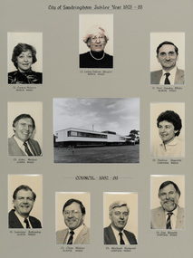
Photograph, City of Sandringham Jubilee Year 1923-83, 1983
Sandringham was originally part of the Shire of Moorabbin. On 28 February 1917, Sandringham was severed from Moorabbin and incorporated as the Borough of Sandringham. It was proclaimed a Town on 9 April 1919 and a City on 21 March 1923. This compilation marks the Jubilee year of the City of Sandringham.sandringham municipal office, councillor, mayor, portrait, municipal building, sandringham, bayside, cr. carmen watson, cr. lesley falloon, cr. paul gundry-white, cr. john merkus, cr. pauline reynolds, cr. laurence bottomly, cr. clem waters, cr. michael harwood, cr. jim bissett, jubilee year -
 Bayside Gallery - Bayside City Council Art & Heritage Collection
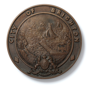
Plaque, City of Brighton plaque
The design of this crest was used by the City of Brighton until 1970, when an official Coat of Arms was issued by the British College of Heraldry. Brighton was first incorporated as a borough on 18 January 1859. It became a town on 18 March 1887 and was proclaimed a city on 12 March 1919. Four circular cast bronze plaques with City of Brighton crest. The outer border surrounding the central crest includes CITY OF BRIGHTON lettering around the top half, two diamonds on the bottom left and right sides with the British Coat of arms at the bottom centre. The central crest depicts the Brighton coastline in relief, with a pier extending to the water, sail boats and a ship in the distance, a train on the right of the pier, a bathing box and trees on the left.plaque, city of brighton, brighton, crest, coat of arms, municipality, bayside -
 Bayside Gallery - Bayside City Council Art & Heritage Collection
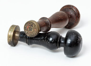
Ceremonial object - Seal, Town of Sandringham and City of Sandringham seals
Council's seals were stamped into hot wax to officialise documents. Sandringham was originally part of the Shire of Moorabbin. On 28 February 1917, Sandringham was severed from Moorabbin and incorporated as the Borough of Sandringham. It was proclaimed a Town on 9 April 1919 and a City on 21 March 1923.Two round brass seals on wooden handles. The longer brown wooden handle seal reads around edge 'TOWN OF SANDRINGHAM' with an illustration of St Edward's crown in centre. The black wooden-handled seal reads around edge 'CITY OF SANDRINGHAM' with an illustration of St Edward's crown in centre. Both seals have mushroom-shaped tops and tapered arms.There are remnants of red wax on both seals.seal, common seal, stamp, town of sandringham, city of sandringham, writing accessory, wax seal, bayside -
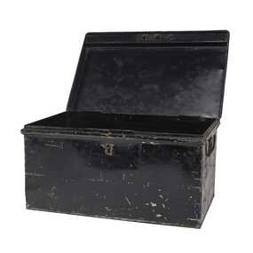 City of Greater Bendigo - Civic Collection
Functional object - Metal Box, Unknown
The first local government authority for Marong was the Marong Road District (an early form of single-purpose local government), which was proclaimed on 19 August 1860. Its boundary was altered twice in 1862 and on 12 December 1864 it was re designated as a Shire. It absorbed Raywood Borough in 1915, and was proclaimed a Rural City in 1990. On 2 December 1994, with the creation of Greater Bendigo City Council, it was abolished by being amalgamated with Bendigo City, Eaglehawk Borough, Huntly Shire, part of McIvor Shire, part of Metcalfe Shire and Strathfieldsaye Shire to form the City of Greater Bendigo. This metal box contained a roll of admission tickets and was possibly used for holding cash at the swimming pool or other municipal facility. Lockable painted metal box. Shire of Marongshire of marong -
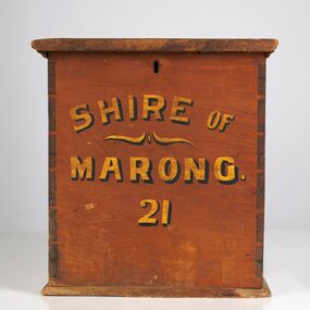 City of Greater Bendigo - Civic Collection
Functional object - Ballot Box, Shire of Marong, Shire of Marong 21, Unknown
The first local government authority for Marong was the Marong Road District (an early form of single-purpose local government), which was proclaimed on 19 August 1860. Its boundary was altered twice in 1862 and on 12 December 1864 it was re designated as a Shire. It absorbed Raywood Borough in 1915, and was proclaimed a Rural City in 1990. On 2 December 1994, with the creation of Greater Bendigo City Council, it was abolished through the amalgamation which took place between Bendigo City, Eaglehawk Borough, Huntly Shire, part of McIvor Shire, part of Metcalfe Shire and Strathfieldsaye Shire to form the City of Greater Bendigo. This box would have been used to collect votes during council elections.Wooden, painted, lidded box with hinged opening lid. Central slit in lid to insert ballot papers. Front face painted in black and gold paint. Hinged at back of box with lock on front. Front of box Shire of / Marong / 21shire of marong -
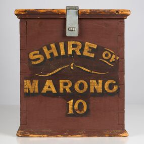 City of Greater Bendigo - Civic Collection
Functional object - Ballot Box, Shire of Marong, Shire of Marong 10, Unknown
The first local government authority for Marong was the Marong Road District (an early form of single-purpose local government), which was proclaimed on 19 August 1860. Its boundary was altered twice in 1862 and on 12 December 1864 it was re designated as a Shire. It absorbed Raywood Borough in 1915, and was proclaimed a Rural City in 1990. On 2 December 1994, with the creation of Greater Bendigo City Council, it was abolished through the amalgamation which took place between Bendigo City, Eaglehawk Borough, Huntly Shire, part of McIvor Shire, part of Metcalfe Shire and Strathfieldsaye Shire to form the City of Greater Bendigo. This box would have been used to collect votes during council elections.Wooden painted, lidded box with hinged opening lid. Central slit in lid to insert ballot papers. Front face painted in black and gold paint. Hinged at front of box with lock on back. Handle attached to the back.Front of box; Shire of / Marong / 21shire of marong -
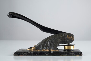 City of Greater Bendigo - Civic Collection
Ceremonial object - Common Seal, Rural City of Marong et al
The first local government authority for Marong was the Marong Road District (an early form of single-purpose local government), which was proclaimed on 19 August 1860. Its boundary was altered twice in 1862 and on 12 December 1864 it was re designated as a Shire. It absorbed Raywood Borough in 1915, and was proclaimed a Rural City in 1990. On 2 December 1994, with the creation of Greater Bendigo City Council, it was abolished through the amalgamation which took place between Bendigo City, Eaglehawk Borough, Huntly Shire, part of McIvor Shire, part of Metcalfe Shire and Strathfieldsaye Shire to form the City of Greater Bendigo. This embosser would have been used over the years by the local council authority. Decorated hand operated cast iron embosser with 50mm stamp head attached. Gold painted decorations on body of embosser only. Lever is also cast iron. Well used showing all over signs of wear. Stamp is for the Rural City of MarongRural / City / of / Marong -
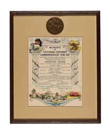 City of Greater Bendigo - Civic Collection
Artwork, other - Commemorative print and medal, Bolton Brothers Printers, 1951
The first local government authority for Marong was the Marong Road District (an early form of single-purpose local government), which was proclaimed on 19 August 1860. Its boundary was altered twice in 1862 and on 12 December 1864 it was re designated as a Shire. It absorbed Raywood Borough in 1915, and was proclaimed a Rural City in 1990. On 2 December 1994, with the creation of Greater Bendigo City Council, it was abolished through the amalgamation which took place between Bendigo City, Eaglehawk Borough, Huntly Shire, part of McIvor Shire, part of Metcalfe Shire and Strathfieldsaye Shire to form the City of Greater Bendigo. This memento commemorates the centenary of gold discovery in Victoria and was presented to school children in the Marong Shire.Framed and mounted commemorative certificate with Victorian Centenary Medal top centre.Memento / of / Victorian Centenary / Commemoration Year 1951 / Shire of Marong -
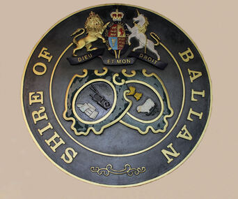 Ballan Shire Historical Society
Plaque, Ballan Shire Seal
The Shire of Ballan was proclaimed in November 1864. The Corporate Seal of the Shire of Ballan appeared first as an impression in September 1867 and as a wax seal in August 1868. This large metal seal was originally mounted on the wall of the Ballan Council Chambers and can now be found in the Ballan Old Courthouse.This is a photograph of the cast metal Corporate Seal of the Shire of BallanSee photographballan shire, ballan shire seal -
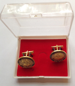 Warrnambool and District Historical Society Inc.
Accessory - Cuff Links, Late 20th century
These cuff links were produced for the Warrnambool City Council presumably to give as gifts to visiting dignitaries etc. They may also have been available for the public to purchase. Warrnambool, first settled in 1847, was proclaimed a Municipality in 1856, a Borough in 1863, a Town in 1883 and a City in 1918. These cuff links are of minor interest as an example of an item produced for the Warrnambool City Council – to use either as gifts or to sell to the public as a memento of the city. These are round metal cufflinks (2) outlined in gold with gold pins (two prongs and a bar) for attachment to the shirt sleeves. The cuff links have the City of Warrnambool logo with gold, blue and cream printing and enamelling. The cuff links are in a plastic box which has a white base and a clear plastic lid and red velvet lining. The cuff links are attached to the inside of the box with black plastic strips. ‘City of Warrnambool, Victoria, By These We Flourish’warrnambool city council, cuff links -
Phillip Island and District Historical Society Inc.
Newspaper clippings, 1888
Extract from The Argus, Monday July 9th 1888 - Griffiths Point Saturday at a Public meeting of the inhabitants of Griffiths Point, held this afternoon to consider the most appropriate name for the newly proclaimed township there. It was unanimously decided on the suggestion of Mr Fraser that it should be called San Remo.Extract from The Argus, Monday July 9th 1888local history, documents, newspapers, griffiths point, san remo, , black & white newspaper clipping, miss elms san remo -
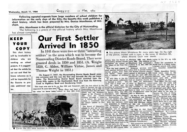 Whitehorse Historical Society Inc.
Article, Our First Settler Arrived 1850, 11/03/1964
A4 photocopy of the history of the City of Nunawadingnon-fictionA4 photocopy of the history of the City of Nunawadingnunawading district roads board, city of nunawading -
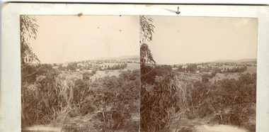 The Beechworth Burke Museum
Photograph - Stereoscopic Photograph
This photograph offers a view of Beechworth, located at the foot of the Victorian Alps. It captures the gorge and native vegetation in the foreground, with the Beechworth township visible in the middle, where the hospital is marked with an arrow. Distant hills form the backdrop. Originally settled c1839, Beechworth was officially proclaimed a town in 1856.This photograph is historically significant as it captures the landscape of Beechworth, providing valuable insight into the town's visual and historical character.Two sepia-toned square photographs showing the view of a town with trees in the foreground and hills in the far distance, mounted.Obervse: Above the right photograph there is an arrow pointing down. Reverse: 97.2195/ View across the Gorge/ looking over Beechworth/ (Hospital under arrow)/ 84-110-1/ A03082beechworth, town, landscape, ovens district, stereoscopic -
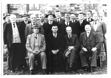 Tarnagulla History Archive
Photograph of Shire of Bet Bet Council, 1952, Shire of Bet Bet Council, 1952, 1952
Murray Comrie Collection. Shire of Bet Bet Proclaimed Sept 20, 1864 Re-defined Feb 10, 1891 Tarnagulla Borough united Oct 1915 Dunolly Borough united Nov 1, 1921 Re subdivision from 5 to 3 ridings Oct 1952Monochrome photograph of a group of men assembled in rows for a photograph. Accompanied by a handwritten note (catalogued separately as a Research Note) with subjects' names. Names of subjects from accompanying note (handwriting difficult to decipher) are believed to be: Left to Right Back/3rd row: Cr J. Grogan, A. Whitehead, G. Barman, J.B. Reid, I.R. Stevens (?), KAG Lowe (Shire Sec), Mr A Rescott (Maryborough Advertiser) Middle row: Crs N.K. Conera (Pres. Elect), D.E. Wood, A. Brownbill, J.P. Mason, D. Clark, K.R. Culleton (Shire Engineer). Front/1st row: Crs G. Fotheringham, J. Fremantle (1951-52), A. Green, J. Hickey. Note also states: 'Secretary Lowe passed away Sept 7, 1952' and 'Fotheringham House, Glenferrie' (location where photograph taken?)tarnagulla, council, bet bet shire, local government, councillors, mayor, shire, engineer, maryborough advertiser, reid, grogan, whitehead, barman, stevens, lowe, rescott, conera, wood, brownbill, mason, clark, culleton, fotheringham, fremantle, green, hickey -
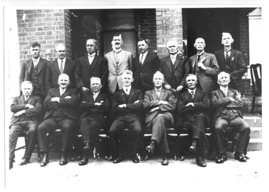 Tarnagulla History Archive
Photograph of Shire of Bet Bet Council, 1935, Shire of Bet Bet Council, 1935, 1935
Murray Comrie Collection. Shire of Bet Bet Proclaimed Sept 20, 1864 Re-defined Feb 10, 1891 Tarnagulla Borough united Oct 1915 Dunolly Borough united Nov 1, 1921 Re subdivision from 5 to 3 ridings Oct 1952Monochrome photograph of a group of men assembled in rows for a photograph. Accompanied by a handwritten note (catalogued separately as a Research Note) with three of the subjects' names. Text from accompanying note (handwriting difficult to decipher): With compliments A. Green (Pres) 3 I know: Geo F., J.B. Reid Don Calder tarnagulla, council, bet bet shire, local government, councillors, mayor, shire, reid, calder -
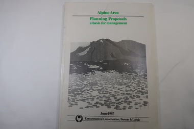 Kiewa Valley Historical Society
Book - Book - Alpine Area - Department of Conservation, Forests & Lands, Alpine Area / Planning Proposals / a basis for management. 1987
It is the policy of the Government that most of the State's alpine area will be proclaimed as an Alpine National Park, which would complement the Kosciusko National Park in N.S.W.. This is yet to be achieved (1987), however there is a need for sound, efficient and coordinated management based on the area's natural features, values and uses. Planning is proceeding on this basis.Victoria's alpine area is one of the State's most outstanding and spectacular natural areas. It is noted for its diverse plant and animal life, scenery, recreation opportunities and as a water catchment. This country is at the upper end of the Kiewa Valley and the planning for it is of interest to the Kiewa Valley inhabitants.White bound book with green print for title at the top, black & white picture and black print at the bottom for the name of the government authority publishing the book.143 pages with fold out map after page 7. The map is coloured green to indicate the planning area.alpine area, bogong national park, victorian department of conservation forests & lands -
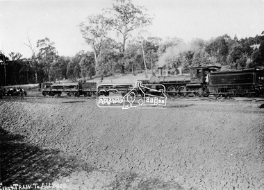 Eltham District Historical Society Inc
Photograph, First train to Hurstbridge
The first steam train to Hurstbridge was probably this one which carried equipment for the construction of the rail line and railway station. The formal opening of the train extension from Eltham to Hurstbridge railway station took place on June 25, 1912. The area was known as Allwood and was offically proclaimed as Hurstbridge in 1924. This photo forms part of a collection of photographs gathered by the Shire of Eltham for their centenary project book, "Pioneers and Painters: 100 years of the Shire of Eltham" by Alan Marshall (1971). The collection of over 500 images is held in partnership between Eltham District Historical Society and Yarra Plenty Regional Library (Eltham Library) and is now formally known as 'The Shire of Eltham Pioneers Photograph Collection.' It is significant in being the first community sourced collection representing the places and people of the Shire's first one hundred years.Digital imagesepp, shire of eltham pioneers photograph collection, diamond creek, hurstbridge, wattle glen, allwood, steam train, construction, railroad -
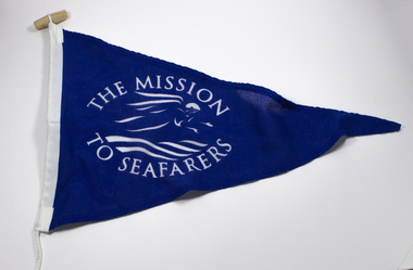 Mission to Seafarers Victoria
Flag - Pennant, The Mission to Seafarers, 20th C
Pennant displaying the flying angel motif without the Bible. The Mission adopted, as its symbol, a flying angel inspired by a verse from the Book of Revelation (14:60) “Then I saw a flying angel in mid-heaven, with an eternal gospel to proclaim to those on earth, to every nation and tribe, language and people”From the personal Collection of Mrs Pat Dann a former member of the Central MtSV and later with her husband Captain Keith Dann supported and founded the Hastings branch of the Mission to Seamen in the late 20th C. Mid-blue polyester fabric triangular Mission to Seafarers (with flying angel motif in white) pennant, with synthetic mounting rope.The Mission to Seafarers in whitepennant, flying angel, mission to seafarers -
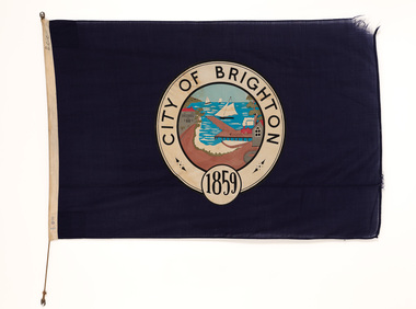 Bayside Gallery - Bayside City Council Art & Heritage Collection
Flag, Evan Evans, City of Brighton flag
This flag features the City of Brighton crest which was used by the City of Brighton until 1970, when an official Coat of Arms was issued by the British College of Heraldry. Brighton was first incorporated as a borough on 18 January 1859, it became a town on 18 March 1887 and was proclaimed a city on 12 March 1919.Navy blue flag with circular crest in the centre with the words CITY OF BRIGHTON 1859 in black ink in a white border around the outside. A polychrome scene of the Brighton crest is in the centre showing the coastline with a pier extending to the water, sail boats in the distance, a train on the right of the pier, buildings on the left and the sandy beach at the base. The flag has rope woven through left side.flag, brighton, city of brighton, crest, bayside