Showing 4549 items matching "historical maps"
-
 Orbost & District Historical Society
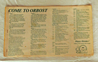
brochure, Come To Orbost, c 1980's
This brochure was produced as a tourist guide to Orbost.This item is a useful research tool.A magazine/brochure for use as tourist information. It contains the history, maps and touring routes of the Orbost district.tourism-orbost -
 Orbost & District Historical Society
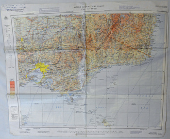
map, 1985
An aeronautical chart is a map designed to assist in navigation of aircraft. Using these charts and other tools, pilots are able to determine their position, safe altitude, best route to a destination, navigation aids along the way, alternative landing areas in case of an in-flight emergency, and other useful information such as radio frequencies and airspace boundaries. World aeronautical charts have a scale of 1:1,000,000 and cover relatively large areas. Orbost Aero Club began in 1969 with Basil Dowie as Chair, David Nixon as Secretary/Treasurer. The group went into recess from 1977-1991 closing in 1997. The mid 1960s were boom years in flying training in Australia and the number of Aero Clubs grew rapidly. The Club played a significant role in the establishment of the small airport at Marlo and in the ongoing operation and development of the airport over the years particularly for patient transfer by aerial ambulance. The Orbost Aero Club Club played a significant role in the establishment of the small airport at Marlo and in the ongoing operation and development of the airport over the years.A laminated map of eastern Victoria. A World Aeronautical Chart. It shows elevations, longitude etc and is designed for pre-flight planning as well as pilotage. Top left hand corner - D.F.N.Nixon VH-FWD 12 Kristine Ct Cheletenham 27/7/87orbost-aero-club aeronautical-map -
 Orbost & District Historical Society
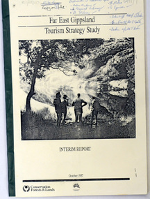
book / document, Far East Gippsland Tourism Strategy Oct 1987, October 1987
The project team for this document comprised E. Beacham, T. Claridge, B. Ebbs, C. Wilso. and J. Cristofaro.This booklet is a useful refernce tool.A document of 86 pp, titled Far East Gippsland Tourism Strategy Study Interim Report October 1987. it has a cream cover and black binding with a b/w photograph of four people in a bushland setting. It contains fold-out maps.tourism-east-gippsland -
 Orbost & District Historical Society
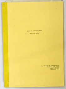
document, BALDWIN SPENCER TRAIL Project Brief 1988, February 1988
This document was produced by the Department of Conservation, Forests & Land Management, Orbost, to commemorate the visit by Baldwin-Spencer in 1989 as part of the Bicentennial Walking Tracks Project. The Baldwin Spencer Trail closely follows the route of scientist and explorer William Baldwin Spencer. Sir Walter Baldwin Spencer KCMG (23 June 1860 – 14 July 1929) was an English-Australian biologist and anthropologist. this booklet is a useful reference tool.A document of 10 pp with a cream cover, titled, Baldwin Spencer Trail Project Brief Feb 1988. It contains mapsbaldwin-spencer -
 Orbost & District Historical Society
map/poster, Victorian Government Printer, 22.4.1926
The Department of Crown Lands and Survey was originally established in 1857 as part of the Board of Land and Works. In 1964 it ceased to be controlled by the Board. The Department functioned for almost twenty more years before being combined with other Ministries to form the Department of Conservation, Forests and Land. It was responsible for the management of the State's Crown land and pastoral estates. This map was used by Don Mehlert after 1928. The VERMIN AND NOXIOUS WEEDS ACT 1928 was an Act to consolidate the Law relating relating to Vermin and Noxious Weeds. E. J. E. G. Pemberton who published this poster was Superintendent of Field Staff, Dept. of Lands and Survey. This map and posters are significant records of early settlement history in Murrangower, between Cabbage Tree and Orbost,A paper map of Murrangower showing settlement subdivisions. This is glued onto the back of four overlapping cloth poster of "Notices of Vermin Destruction". All print is black."DON MEHLERT" in black pen. Pike's block shaded in blue. School site marked in blue pencil. on poster "MURRANGOWAR" along side.map-murrangower poster-vermin-and-noxious-weeds murrangower-settlement -
 Orbost & District Historical Society
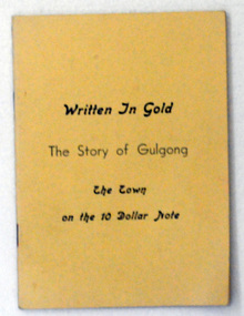
book, Written in Gold, 1966
This is the third edition of this book.This is a useful reference tool.A thin 56 pp paper back book with a pale yellow cover. On the cover in black print is the title, "Written in Gold the story of Gulgong the town on the 10 dollar note". It contains a history of Gulgong, maps and illustrations.gulgong-history bank-notes -
 Orbost & District Historical Society
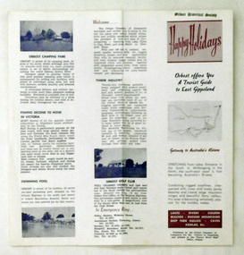
pamphlet, Snowy River Mail, Happy Holidays
This pamphlet was probably produced for use in the Slab Hut (Orbost Visitor Information Centre)These pamphlets are useful reference tools and reflect the tourism history of the local area.Two single page tourist brochures, printed on both sides and folded in the middle. They are white with pink and blue print. and have a map of East Gippsland and descriptions of places to visit.tourism-orbost -
 Orbost & District Historical Society
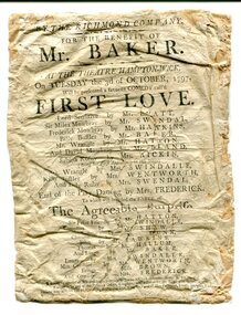
program, 1797
"The theatre itself was located in a barn close to the village pond. Its location is indicated on the attached 1827 map of Hampton Wick and the Swan arrowed where tickets were to be had. The picture of Ye Swan around 1900 is probably not too dissimilar to how it would have looked in 1797. One of the regular patrons at the theatre is believed to have been William, Duke of Clarence (later King William IV, uncle of Queen Victoria). The Duke lived in Bushy House about a mile away from the village and was a known devotee of theatrical entertainments. The theatre had disappeared by 1865. It would have been a touring company who were playing on the night of 3 October 1797." ( information from Ray Elmitt, historian of Hampton Wick ) The doors were to be opened at 6 to begin precisely at 7 o'clock,. Boxes were 3 shillings, Pit seats were 2 shillings and seats in the gallery were 1 shilling. Tickets could be bought at the printing office in Kingston or from Mr Ansel of Adam and Eve in Kingston or from Mr Pattenden of the Swan in Hampton Wick. "First Love" is a 1795 sentimental comedy play by the British playwright Richard Cumberland. It was first performed at the Drury Lane Theatre in May 1795. Frederick Mowbray becomes the protector of Sabrina Rosny after her abandoment by Lord Sensitive. The Agreeable Surprise is a 1781 comic opera to music by Samuel Arnold and a libretto by John O'Keeffe. The work in two acts was first performed at the Theatre Royal, Haymarket (London), on 3 September 1781. It was one of the most performed works of its kind in London in the last quarter of the 18th century. In England the 18th century saw the flourishing of theatre as a popular pastime. Many theatres were enlarged and new playhouses built in London and the provinces. This item was kept as a souvenir / memento and brought to Australia by an early settler.A very old program from the Richmond Company at the Theatre Hampton-Wick. It is white with black print. There are two performances - First Love and The Agreeable Surprise. There is a cast list for each. theatre hampton-wick-richmond-company -
 Orbost & District Historical Society
book, Snowy River Mail as "Mail" Print, Princes Freeway Orbost Section, 2117.1 : 1976 2117.2 : 4.9.2013
The Snowy River Bridge, Princes Freeway, Orbost, Victoria was opened by the Hon. J A Rafferty, Minister for Transport, 25 November 1976. ‘The bridge was built at a cost of A$2.4 million and is the first of four bridges to be built as part of the 8.4 kilometre freeway bypass of Orbost. Construction of the bridges commenced in January 1975, with an expectation to open the bridge across the Snowy River as soon as possible. Less than two years later, on 25 November 1976, the bridge across the Snowy River was opened to traffic, allowing the old bridge to be demolished. The remainder of the Orbost Bypass, both the floodplain crossings and the eastern section around the township itself, was declared ‘Princes Freeway’. The newspaper article was written by David Jellie as part of the centenary celebrations of Vic Roads/Country Roads on 4.9.2013. David Jellie was the project engineer for the Snowy River Crossing Project.This book and article contain historical information and details about the construction of the bridges on the Orbost section of the Princes Freeway.2117.1 isaA thin paperbook book which contains a map, history and construction details of the Princes Freeway at Orbost. It has a program for the opening ceremony of the snowy River Bridge in 1976. 2117.2 is an article from the snowy River Mail on the history of the highway. It is dated 4.9.2013.In pencil - 20csnowy-river-bridge jellie-david princes-freeway-orbost -
 Orbost & District Historical Society
magazines, East Gippsland Victoria, 1978
The magazine is a travel book and is probably one of a series.A glossy magazine titled, East Gippsland - Victoria. It contains coloured photographs. This is a 24pp travel book containing coloured illustrations, maps and descriptions of East Gippsland. There are historical details/articles in the book. The photography is by George Hurdes and Ian Roberts. The cover which was designed by Bill Stockdale has a colour photo of a yacht with a predominantly blue background of water and sky. The text is by Barbara Glover.travel east-gippsland -
 Orbost & District Historical Society
folder and photographs, Leatch, May, February 2005
From an interview by Ngaere Donald and May Leatch.Rabbits had been reported in Orbost from 1899. Prior to the introduction of myxomatosis, there was an active export trade in rabbit skins and meat. The main market for canned rabbit meat was the United Kingdom and most skins were exported to the USA.. In Orbost there was a Rabbit Skin Buyers' Shed.1904.1 is a manila folder with printed information and a hand -drawn map. There are four coloured photographs of the Tyndall Street Old Hide Merchants shed with Lachlan Macalaster standing in the doorway. macalaster-lachlan rabbit-skin-buyers-shed hide-merchant -
 Orbost & District Historical Society
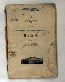
book, The Story of the Settlement and Development of Bega, 1942
... maps, newspaper clippings of historical articles, official... settlers. It also includes maps, newspaper clippings of historical ...After being out of print for 30 years this book has been reprinted in 1987 as a tribute to W.A. Bayley (dec.). WA Bayley had been a public school teacher and was principal of Bega Intermediate High when he researched and wrote his history in the 1940s. He wrote history books on all the towns where he worked,A 120 pp book titled "The Story of the Settlement and Development of Bega". The author is William Alan Bailey (1910-1981). it was published by Bega Intermediate High School.The book contains biographical sketches of some of the early settlers. It also includes maps, newspaper clippings of historical articles, official and handwritten correspondence. The cover title is History of Bega. bega bayley-w.a. bega-settlement -
 Orbost & District Historical Society
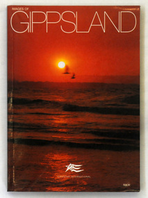
book, Images of Gippsland, C 2008
A paperback book with a bright orange cover of a sunset over a beach, The title text is in white. The book contains maps and coloured photographs. It is written by Alexandra Stevens and photographed by Barry Stevens. It is designed as a souvenir book with 240 pp.gippsland photography souvenir -
 Orbost & District Historical Society
map/brochure, Discovering Marlo & The Snowy River Estuary, December 1988
In 1983 the Department of Conservation, Forests and Lands replaced the Department of Crown Lands and Survey, the Department of State Forests and the Ministry for Conservation. This brochure/map was used as tourist information in Orbost.This item is a useful research tool.A folded map/brochure titled "DISCOVERING MARLO & THE SNOWY RIVER ESTUARY". On the front is a photograph of Marlo and the title in yellow print. There is a locality map for access to Corringle beach and the brochure Includes a key to fishing sites and various tourist locations. On the back of the brochure are notes on fishing, wildlife and a boating guide, map brochure snowy-river marlo -
 Orbost & District Historical Society
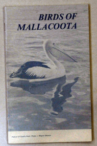
book, Birds of Mallacoota 1979, August 1979
This book was produced at the Mallacoota Central School. Bruce Pascoe wrote the introduction for the book. He was teaching at Mallacoota.This book is a valuable reference book which is used by ornithologists to compare recordings of bird sightings in Mallacoota.A small 52 pp book titled Birds of Mallacoota 1979. On the front cover is a photo of a pelican at Coull's Point, Mallacoota. The photo was taken by Wayne Stevens. The title is in black. It contains photographs and maps.book birds mallacoota pascoe-bruce -
 Orbost & District Historical Society
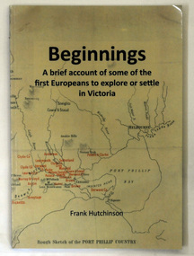
book, Beginnngs, 2011
"A map on the wall of his parent's shop in country Victoria is what got Frank Hutchinson interested in the geography and early settlement of Victoria. He later moved to Ballarat where he spent most of his working life. Whilst there his interest in the early explorers continued until about ten years ago he began to compile the listing which developed into the present publication." (ref.Port Phillip Pioneers Group) When he commenced the research and writing of Beginnings, it was not intended for publication. It was a project of personal interest. A soft covered 122 pp book title Beginnings a brief account of the first Europeans to explore or settle in Victoria. On the glossy front cover is a rough map of Port Phillip Bay. Print is black. a chronological list of the earliest visits to Victoria and attempts to settle. The book contains: brief notes on the exploration and earliest settlement of the state, region by region and a summary of the early Murray River paddle steamer industry.hutchinson-frank history-victoria prahran-mechanics-institute -
 Orbost & District Historical Society
book, Broadbent's Melbourne - Sydney Guide Book, 1936
Broadbent's Official Road Guides Company took over George R. Broadbent's business in 1935. In 1963, it changed its name to Broadbent's Road Maps Pty. Ltd. George Robert Broadbent (1863-1947), cyclist and map publisher, was born on 3 November 1863 at Ashby near Geelong, Victoria. At various times Broadbent held most Victorian and Australian road cycling records. Broadbent became an active vice-president of the Good Roads Association of Victoria in November 1912 and was consulted regularly during the preparation of the country roads bill. That year he took over the Argus motoring column, wrote tirelessly on road improvements and maintenance, and became manager of the Automobile Club's new touring department in 1914.A 160 pp road guide book titled Broadbent's Official Road Guide Melbourne - Sydney. The front cover has a yellow background with a map of the coastline from Sydney to Melbourne, the Prince's Highway route marked. This is inset in a drawing of a car driving along the coastal road.The book contains speedometer readings, route maps, advertisements and photos of points of interest. In the top right is the logo of the Royal Automobile Club of Victoria and at the bottom right is the price 1/-.traavel road-guides broadbent-george car-touring -
 Orbost & District Historical Society
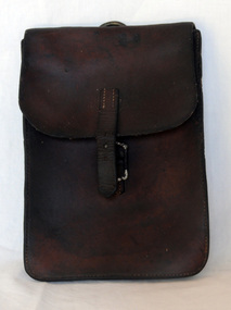
document bag, Early 20th century
A brown leather document/map bag. It is envelope style with a rusted silver coloured buckle. On the back is a silver coloured metal ring to attach to a saddle. The flap has a small strap to close the buckle.leather-case document-holder -
 The Beechworth Burke Museum
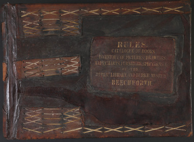
Book - 1875 Catalogue, William Detmold, RULES / CATALOGUE OF BOOKS / INVENTORY OF PICTURES, DRAWINGS, / MAPS, CHARTS, FURNITURE, SPECIMENS / OF THE / PUBLIC LIBRARY AND BURKE MUSEUM / BEECHWORTH, 1875
This large, leather bound journal was made for the Public Library and Burke Museum in Beechworth by book manufacturer, William Detmold in 1875. It was commissioned by the President of the Library and Burke Museum committee, Dr Antoine Mousse, for the purpose of cataloguing all the items in the collection. The cataloguer was the curator at that time, William Morton, whose hand-writing appears in the journal today. When William Morton first started recording in this journal in 1875, there were already a number of existing items in the institution. The Public Library and Burke Museum in Beechworth had actually been operating since the 1850s; first as a Young Men’s Association in 1856, then as Beechworth Athenaeum in 1858, then as the Beechworth Public Library in 1860. Then in 1861 when news of the death of Beechworth’s former police superintended, Robert O’Hara Burke, reached the town, it was agreed that the Public Library would also become a museum to tribute his legacy, renaming it as the ‘Public Library and Robert O’Hara Burke Memorial Museum, Beechworth’. Many of the items from the early institutions would have been used to form the nucleus of this new organisation. Plus, the additional items that were either collected or donated to develop it into a museum. The catalogue is extensive. There are exactly 461 pages of recorded items, each page detailing the various collections the museum acquired in the late 19th century. Collections recorded in this catalogue include a large collection of geological specimens, that were given to the museum in 1868 by the Geological Survey Department of Victoria. A large collection of taxidermy mounts, that were given to the museum as skins by the Museum of Australia in 1865. An extensive collection of Aboriginal artefacts that were purchased from amateur anthropologist R. E . Johns in 1868. As well as artworks, charts, photographs, machinery, maps etc., all of which have been held in the museum since. This catalogue also details the governance and management of the organisation. There were originally 30 rules that governed the actions for the management committee and, while anyone could read in the free library, only subscribers could borrow two books and one periodical. At first, subscriptions rates were 7/6 a quarter. This was later changed to £1 per annum, paid quarterly in advance. This was a considerable amount; 7/6 per quarter meant that the annual fee was £1.10. This was equivalent to about £650.00 or about $1,182.00AUD today, while the reduced subscription fee of £1 a year was the equivalent to £450.00 or about $818.00AUD today. Membership of the athenaeum would have been the reserve of the town's notable citizens. The vale of the catalogue lies not only in its historical connect with the establishment of the Athenaeum and the current museum, but also in its record of the names and positions of all members of the institution's committees of management from 1875-1876. This is a unique object that contains important records for a notable country town. Large brown leather bound book made in 1875 for the Beechworth library and museum by William Detmond. Inside is a comprehensive and detailed itemised listing of the paintings, drawings, charts, photographs, specimens and books that entered the institution from 1850 -1882. non-fictionCover: RULES / CATALOGUE OF BOOKS / INVENTORY OF PICTURES, DRAWINGS, / MAPS, CHARTS, FURNITURE, SPECIMENS / OF THE / PUBLIC LIBRARY AND BURKE MUSEUM / BEECHWORTHburke museum, beechworth, catalogue, museum catalogue, 1875, william morton, william detmold, exposition universelle, ferdinand von mueller, public library, collection, book, leather bound, restored, digitised, robert o'hara burke, hand-written -
 Ballan Shire Historical Society
Map - Map. Bungal, Department of Lands and Survey, Bungal, County of Grant, 09/09/1926
A map of Bungal in the 1920's showing the allotments, and the size, with the names of the residents. It shows the roads and the Western and Eastern Moorarbool River, and the Whipstick State Forest.Cream coloured map of Bungal in the County of Grant, bounded by the the East Moorarbool River on the East, and the State Forest on the South. It is marked with the scale of chains and the number L.358. Lithographed at the Department of Lands and Survey. Melbourne by W. J. Butson on 9.9.1926. It shows the land allotments with names of owners.Coloured pen marks and circled numbers on various areas. Price 2 shillings marked on bottom right hand edge.bungal, kerrit bareet, egerton, lal lal, borhoneyghurk, bungeeltap, ballark, yaloak, gorong, moorarbool west -
 Ballan Shire Historical Society
Map - Map. Ballark, Department of Lands and Survey, Ballark. County of Grant, 31/08/1915
A map of the Ballark area within the County of Grant showing roads, waterways, property boundaries and property owners in 1915.Significant to people researching land usage and ownership. Also those researching families in the area at that time.A map of Ballark in the County of Grant. Black printing on buff coloured paper. Extra notations by hand and various coloured highlighting of certain features. Details roads, rivers, property boundaries and names of property owners and districts. The map is easily readable although there is some physical damage to the borders and some sellotape residue. Shows a scale in Chains and the number L.6030Various numbers and directional arrows added to map.bungal, borhoneyghurk, bungeeltap, ballark, beremboke, moreep, meredith, morrisons, moorarbool river -
 Ballan Shire Historical Society
Map - Map. Kerrit Bareet, Department of Lands and Survey, Kerrit Bareet. County of Grant, 08/1944
A map of the Kerrit Bareet area within the County of Grant showing properties and names of owners in 1944.Significant to people researching land usage and ownership. Also those researching families in the area at that time.A map of Kerrit Bareet in the County of Grant. Black printing on buff coloured paper. Details roads, rivers, railways, property boundaries and names of property owners and towns and villages. The map is easily readable although there is some physical damage and that and the borders have been reinforced with sellotape. Shows a Scale in Chains and Price 2/.gordon, bungal, kerrit bareet, lal lal, moorarbool river, warrenheip, bungaree, wallace, moorarbool west -
 Ballan Shire Historical Society
Map - Map. Bullarook State Forest, Bullarook State Forest Reserve
A small map of the Bullarook State Forest Reserve. Drawn on a fine buff coloured paper attached to a stiff cloth backing sheet. The title is hand written and includes a "scale one mile to one inch" hand written also. The map is signed "John Wrigglesworth, assistant ? and dated 26/6/1869" although the month and year are almost illegible.moorabool west, state forest, bullarook, eastern moorabool river, werribee river, moorabool east, blakes saw mill, wombat, andersons saw mill -
 Ballan Shire Historical Society
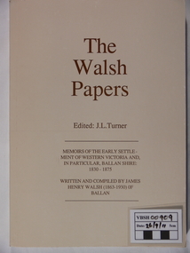
Book - Book. The Walsh Papers, The Walsh Papers, 1985
The former Shire of Ballan commissioned this work which ties in with the formation and early years of the Ballan Shire Historical Society. It is a collection of articles, works and memoirs written and compiled by James Henry Walsh, an early resident of Ballan, that have been edited for publication by James Turner. The book contains maps and photographs and is fully indexed. It is considered by some to be the foremost reference work on the history of Ballan.The book is significant as it is a comprehensive collection covering the history of Ballan. It is a limited edition and now out of print.A soft covered book, ivory in colour. Printed on the cover is - "The Walsh Papers. Edited: J.L.Turner. Memoirs of the early settlement of Western Victoria and, in particular, Ballan Shire: 1830 -1875. Written and compiled by James Henry Walsh (1863 -1930) of Ballan." The back cover is a full page sepia photograph of James Walsh (head and shoulders only) and the printed number "ISBN 0 95599911 1 5". Book No.106. 312 pages.The book bears the stamp of the Ballan Shire Historical Society and the handwritten marking "Receipt P.1." Book No.106 and Reg No. (VC) 00909 in pencil.walsh james henry, ballan memoirs, turner j l, ballan history -
 Ballan Shire Historical Society
Map - Map. Shire of Ballan, Shire of Ballan
This is a fairly comprehensive map of the former Shire of Ballan which is now amalgamated into the Shire of Moorabool.A black and white map of the Shire of Ballan showing major roads, rivers, towns, settlements, State parks and forests and land subdivisions. It appears to be a copy of the original as no dates or maker or printer appear on the map. There is a scale of 2 miles to 1 inch.gordon, ballan, bungal, kerrit bareet, borhoneyghurk, bungeeltap, ballark, yaloak, gorong, beremboke, wallace, ingliston, hunterston, millbrook, bradshaw, myrniong, blackwood, moorarbool, greendale, bayup, trentham, bullarto, korweinguboora, glenlyon, bolwarra -
 Ballan Shire Historical Society
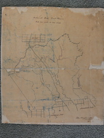
Map - Map. Moorarbool East and West, Country Lands in the Parishes of Moorarbool East and Moorarbool West. Counties of Bourke and Grant
This is a map of "Country Lands" around the Werribee River, north of Ballan in the Counties of Bourke and Grant.A relatively small map, paper on a material backing. Shows topographical features, roads and property divisions. Scale of forty chains to one inch. The map is dated March 31st, 1859.There is a small inscription under the chain scale that reads "No 58/364 John Phillips ? Survey 1st August 1858". The name Dugald McPherson is hand written on one of the blocks of land.moorarbool west, moorarbool east, dugald mcpherson, county of bourke, county of grant, werribee river, ballan -
 Ballan Shire Historical Society
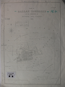
Map - Map. Ballan Township, Plan of Ballan Township in the Counties of Bourke and Grant
The map is an early one of the township of Ballan showing street names and land owners.The map is significant in that it lists the owners of the house blocks within the township.A map showing the township and surrounding area of Ballan in 1856. Town streets are named as are the owners of the subdivided blocks of land. The map is a lithocopy and there is a scale in chains."D D Fraser" is written across the top of the map and "1856" is written in the near top right corner. There are other additions to the map but they are very difficult to decipher accurately or completely.ballan, ballan township map, ballan1856 -
 Ballan Shire Historical Society
Map - Map. Korweinguboora, Department of Lands and Survey, Korweinguboora. Counties of Talbot and Grant
A map of the Korweinguboora area showing roads, forests, railway lines and properties with the owners names.The inclusion of the names of landowners is of significance and value to historians.A map of the Korweinguboora area showing land subdivisions and names of owners and other physical features. There is a scale in chains. No date is certain but it could be 1902. The map has been repaired with sellotape.There are various pencil annotations but the are difficult to read.talbot, moorarbool west, wombat, bullarto, korweinguboora, moorarbool east, dean, wombat state forest, barkstead -
 Ballan Shire Historical Society
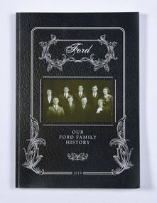
Book - Book, Ford - Our Ford Family History, 2015
A history of the Ford Family and descendants, pioneer settlers of the Morrisons/Meredith area in Victoria. Contains photographs, family trees, documents, newspaper cuttings, maps, narratives etc. Black and white only.This book is significant in that it contains valuable historic information on the Ford and Brawn families. The publication is private and intended for the information and interest of family members and others researching the family.Book, soft cover, perfect bound, with a leather look cover and a photograph of family members with a scrollwork surround.ford, brawn, bant -
 Flagstaff Hill Maritime Museum and Village
Document - Navigation Chart, Admiralty Office, Lady Bay and Warrnambool Harbour, 03/04/1871
This Chart titled “Lady Bay and Warrnambool Harbour” was surveyed by Nav. Lieut. H.J. Stanley, of Britain's Royal Navy, in 1870 and printed in April 1871. The chart was made before the Warrnambool Breakwater was built (construction had begun in 1874 and was completed in 1890). The chart includes Directions for entering Lady Bay, Warrnambool Harbour. These are "Vessels entering Warrnambool Harbour must bring the Red Light in sight and steer in with it in line with the upper white Light bearing North, until the Green Light on the Jetty is opened, when steer towards it and anchor. The best anchorage is in 2 ¼ fms [fathoms)] of water, about a cable from ledge off Breakwater rock. Or where convenient, according to draught of water, only endeavouring to anchor as close as possible to Breakwater rock. It is not safe to enter or leave the Harbour in south westerly or Southerly gales.” This chart is significant for its strong connection to the maritime history of Warrnambool Harbour and Lady Bay, and eventually to the Warrnambool Breakwater. The Warrnambool Breakwater is registered as a place of significance on the Victorian Heritage Database (VHR H2024). A copy of the same chart was used to plan several submissions for future changes to the jetty and breakwater. The chart is a historical record of structures existing in 1870; the Warrnambool Jetties, Lady Bay, the leading lights (lighthouses), streets, roads, bridges and many buildings. It also shows the lay of the land and seabed.Canvas chart of Australia, South Coast, Victoria Title: Lady Bay and Warrnambool Harbour Surveyed by Nav. Lieut. H.J. Stanley, R.N., 1870. Magnet Variation, 1870 Published April 3, 1871, by the Admiralty, London. Directions for vessels entering Warrnambool Harbour are printed on the chart. The chart has a lacquer or seal over it.Top of chart has logo "HYDROGRAPHER OFFICE" "Price Eighteen Pence". "Engraved by Edward Weller" Along bottom of Chart: “London… Published at the Admiralty, 3rd April 1871, under the Superintendence of Rear Admiral G.H. Richards, F.R.S. Hydrographer, Corrections July 71” Bottom of chart “Australia South Coast Victoria Lady Bay and Warrnambool Harbour. 2494”flagstaff hill, warrnambool, chart of lady bay warrnambool 1870, warrnambool harbour, cartography, navigation, warrnambool breakwater, 1871, australia – south coast / victoria, lady bay, 1870, nav. lieut. h.j. stanley, r.n, directions for entering warrnambool harbour, hydrographer office, rear admiral g.h. richards, edward weller, port of warrnambool, flagstaff hill maritime museum & village, maritime museum, maritime village, shipwreck coast, map, chart, navigation chart, admiralty chart, breakwater, jetty, pier, vhr h2024