Showing 1073 items matching "south melbourne city"
-
![Newspaper Clipping, Diamond Valley Leader, Fine mess at school [MS4925], 31/05/2017](/media/collectors/4f729f5697f83e03086015b8/items/599e485821ea69168c864b42/item-media/59a294d121ea670d006fe368/item-fit-380x285.jpg) Greensborough Historical Society
Greensborough Historical SocietyNewspaper Clipping, Diamond Valley Leader, Fine mess at school [MS4925], 31/05/2017
A revenue raising tactic by Banyule Council is putting the lives of young children at risk, according to a group of angry parents at Montmorency South Primary School.News article 1 page, black text, colour image.montmorency south primary school, banyule city council -
 Glenelg Shire Council Cultural Collection
Medal, Centenary of Melbourne 1835 Commemorative Medallion, 1834
White metal medal issued to commemorate Melbourne's centenary 1934-35. This medal was given out to Victorian school children; 325,600 white metal medals were struck. There were also a few VIP pieces in other metals, including two in gold. The medal references Portland, the location of Victoria's first settlement. The Henty brothers, entrepreneur farmers and whalers, established the state's first permanent European settlement in Portland in 1834. Melbourne was established the following year by a party of settlers led by John Batman.White metal medal. Medal, silver. with hole and ring at the top. Obverse: Sailing Ship, Coast, Boat on shore, 3 men. Reverse Colonial man on grass, river, city buildings on other river bank Medal commemorates the centenary of Victoria and Portland 1834 and Melbourne 1835. Obverse:Scene of landing at Portland Bay; in ground below, PORTLAND / 1834; above, centenary of victoria / 1934 Reverse: Pioneer on south bank of Yarra looking across to Melbourne, below 1835 above, CENTENARY / OF / MELBOURNE / 1935Front: Inverse: Centenary of Melbourne 1835 (Top) 1835 (Bottom) Back: Obverse: Centenary of Victoria 1934 (Round Top) Portland 1834 (Bottom)medal, numismatics, celebration, 1834, 1934, 1935, melbourne, portland -
 City of Moorabbin Historical Society (Operating the Box Cottage Museum)
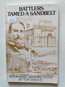
Book, Thomas Arthur Sheehy, Battlers Tamed a Sandbelt : Moorabbin 50 Years a City, 1985
A hard cover book, published and printed in City of Moorabbin 1985.non-fictionaustralia, moorabbin, tommy bent, history, sandbelt, market gardens, golden jubilee, 150th. anniversary, victoria, -
 City of Moorabbin Historical Society (Operating the Box Cottage Museum)
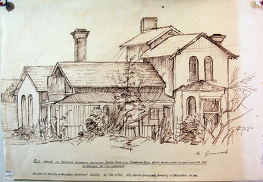
Drawing, of early house Cummins Road Moorabbin, c1950
A pencil sketch of an early house on the corner of South Road and Cummins Road by Marian Grimwade. signed : M Grimwademoorabbin, bbrighton, early settlers, bentleigh, nepean highway, arthur's seat road, moorabbin district roads board, market gardeners, artists, grimwade marian, -
 City of Moorabbin Historical Society (Operating the Box Cottage Museum)
Document,photocopy plan 'Two Acre Village 'c1852, c1960
In the 1852 Josiah Holloway, a developer, purchased 625 acres from the squatters Richard and John King and sectioned '2 acre allotments' south of Henry Dendy's Brighton Survey along the Arthur's Seat Road ( later Nepean Highway) for sale @ £10 It became known as The Two Acre Village as settlers took up the allotments and established market gardens, general stores, butchers, blacksmiths, post office and 2 hotels. Charles Whorral opened The Cheltenham Inn and it became so popular as a meeting place that the area was called Cheltenham. The early settlers, who were predominantly English and Scottish immigrants initially leased their allotments and, because the sandy soil was so fertile, they were soon able to purchase the land and increase their acreage. Cheltenham became a very important part of the large Moorabbin Shire1871 and City of Moorabbin 1934 In the 1994 Amalgamation of Councils, when the large City of Moorabbin was divided between the newly formed Glen Eira, Kingston and Bayside Councils, the Cheltenham area was assigned to the City of Kingston A photocopy of the Plan for the 2 Acre Village in Moorabbin Parish c1852. A3 laminatedmoorabbin, brighton, cheltenham, market gardeners, pioneers, early settlers, , king. john, holloway josiah, whorral charles, arthur’s seat road, nepean highway , cheltenham inn hotel, henry dendy special survey 1841 -
 City of Moorabbin Historical Society (Operating the Box Cottage Museum)
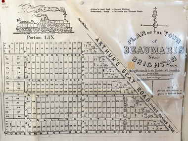
Document, photocopy of Plan of Beaumaris 1853, c1960
Beaumaris includes two early estates in the parish of Moorabbin developed by Josiah Holloway from 1852. Named Beaumaris Town and Beaumaris Estate (after the pastoral run in the area and ultimately after Beaumaris in Wales), the lots comprising them were marketed by Mr Holloway's suggesting that the railway was imminent and a canal would be built. The township developed slowly, a Post Office opened on 1 March 1868, but was replaced next month by Gipsy Village office (now Sandringham) In 1862 Beaumaris was one of the early settler communities within the boundaries of the Moorabbin District Roads Board , the region’s first local government authority. Beaumaris is a suburb in Melbourne, Victoria, Australia, 19 km south-east from Melbourne's central business district. .Since the Amalgamation of Councils 1994 the local government area is the City of Bayside which includes Brighton. A Photocopy of the Plan of Beaumaris 1853 A3moorabbin, county of bourke, brighton, beaumaris, pioneers, early settlers. market gardeners, cheltenham, king. john, holloway josiah, whorral charles, arthur’s seat road, nepean highway, morabbin district roads board, sandringham, mordialloc, mentone -
 City of Moorabbin Historical Society (Operating the Box Cottage Museum)
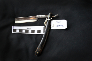
Personal Effects, Cut-throat razor ‘Bengal’, early 20thC
Bengal’ THOMAS RADLEY CADMAN & SONS St. Mary's Road, Sheffield In business at least 1892-1919 Originally a trademark of Luke Cadman, Sheffield, England from ca. 1748-1906. From ca. 1906 - 1953, used by: Thomas Radley Cadman & Sons St. Mary's Road, Sheffield. In business at least between 1892 and 1965. The Cadman family originally came from Derbyshire and settled in the village of Eckington, to the south of Sheffield. Luke Cadman (1727-1788) moved to Sheffield in 1740 and became apprenticed into the cutlery trade. He became a freeman of the Cutlers' Company of Hallamshire in 1748 and was granted the trademark "BENGALL". (Another branch of the family was granted the trademark "SENEGALL"). Two of Cadman's sons followed him into the business. The Cadmans' business was located at various addresses in Sheffield over the years. In the early 1870s Thomas Radley Cadman (1833-1917) took over the firm. By 1933 the firm had diversified into safety razor and pocket knife manufacture. T.R.Cadman & Sons, Ltd. ceased trading in 1965. A man's cut-throat razor that folds to protect the blade inside the handle , 'Bengal'on blade 'BENGAL'cut-throat razors, straight razors, shaving equipment, steel blades, sheffield steel, england, thomas radley cadman & sons ltd., cutlers, steel manufacturers, ‘bengal’ trade mark, early settlers, market gardeners, moorabbin, bentleigh, cheltenham, -
 City of Moorabbin Historical Society (Operating the Box Cottage Museum)
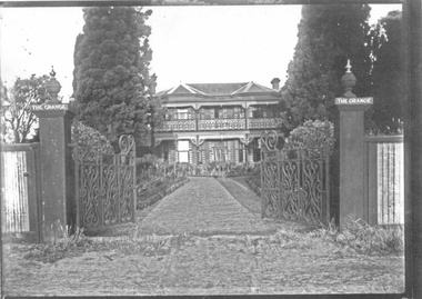
Photograph - 3 black & white Photographs, 'The Grange' ( 'Baydon Hill' ) Moorabbin, c 1920
'The Grange ' was a 2 storey home built 1857 by Mr Charles Tuck, originally named 'Baydon Hill' , at 1011 Nepean Highway, Moorabbin ( South Brighton). Mr Charles Tuck was Veterinary Surgeon from Baydon Hill, Wiltshire, England, who migrated to Australia c1850. He married his cousin Miss Jan Chaudler in Melbourne in1853. He was at the Ballarat gold-fields at the time of the riots and then they settled in South Brighton ( later Moorabbin) and built a large Georgian Styled home called 'Baydon Hill'. The Tucks had a large family - 9 children. Charles enjoyed a prosperous Veterinary Practice as his advice was needed for stock purchases by the farmers / settlers. Charles died in 1893 and Jane left the property c 1903 and died at Blackburn in 1928. The House had 5 owners, the last being the Healey family c1920 and at some stage the name was changed to 'The Grange' and the gates shown were installed. The Healey Family were also prosperous in developing vegetables and flower seeds and seedlings. 'The Grange' was sold to Moorabbin City Council 1972 and then used by the City of Moorabbin Historical Society for meetings and storage of historical material. It was demolished amidst considerable controversy 1983 and the District Police Offices were built on the site. ( S.T.Mulvany, Grand-daughter of Charles Tuck 26/7/1974)The Grange was a significant property 1853 -1983 in Moorabbin. It was built by Mr Charles Tuck 1857and in1900 extended from Point Nepean Road to South Road - 10acres. Mr Harold James Healey purchased the property in c1920 and leased a portion to a Chinese market gardener. Later with his sons he established a profitable Plant Nursery that they managed for 42years.. Keith Healey, a son, remodelled the house extensively mid 20thC .The Moorabbin City Council purchased it in 1972 for $255,000 and it was demolished amid controversy 1983. The District Police Offices are now on the site.3x black and white photographs of the property at 1011 Nepean Highway Moorabbin built by Mr Charles Tuck c1853 known as 'The Grange'. Originally it was named 'Baydon Hill' because he migrated from Baydon Hill, Wiltshire, England c1850. These photographs are c 1880, 1920 and 1950 showing the original and later additions made to the property by some of the 5 owners.Written in pencil on back a) " This Photo donated by Mr Neil Follett - at the time it came into his possession he had a photography studio in Cheltenham. Photographer unknown"; Folio 6 b) The Grange c 1950 Folio 6/10 c) 'Baydon Hill' ( alias "The Grange" ) / Donated by Mrs Elsa Jones, daughter of Leslie Stephen Tuck, youngest son of Charles Tuck Folio 6 /18tuck charles, tuck jane, veterinary surgeons, livestock, market gardeners, early settlers, dendy's special survey, brighton, moorabbin, ballarat, gold diggings, horses, chickens, cattle, bullocks, flower shows, fruit garden, mulvaney s. t., healey haold james, healey keith, moorabbin city council, chinese market gardeners, plant nursery, tuck leslie stephen, jones elsa -
 City of Moorabbin Historical Society (Operating the Box Cottage Museum)
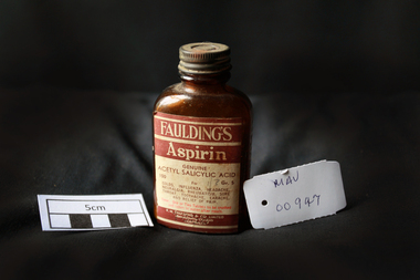
Manufactured Glass, brown bottle 'Fauldings Aspirin', c1950
Francis Hardy Faulding 1816 – 1868 arrived in Sydney 1842. He was a Surgeon on the emigrant ship Nabob. 1845 Francis Hardy Faulding opened his first pharmacy at 5 Rundle Street in Adelaide and the business prospered. In 1867 he formed F.H Faulding & Co with Luther Scammel. as wholesale druggists and manufacturing chemists. Two of the Faulding company's major innovations were the development of a process for distillation of eucalyptus oil, and the development of the test for determining the eucalyptol content of the oil. Faulding's success was founded on eucalyptus oil, which formed the basis of an antiseptic marketed as "Solyptol" In 1868 Francis Hardy Faulding died, aged 52 at his suburban Glen Osmond home in Adelaide. Scammel’s two sons took over the business in 1888 and in 1890 the Company expanded to West Australia, then Sydney, Brisbane and finally, in 1924, Faulding began operations in Exhibition Street, Melbourne, eventually adding wholesale activities. 1986 With a presence in every city, from Darwin to Tasmania. Faulding becomes a truly national company. 2008 Zuelllig Group takes control Focusing solely on pharmaceutical wholesaling and distribution, Hong Kong based Zuelllig Group takes over control of Symbion Pharmacy Services. 2008 Symbion Pharmacy Services exceeds $3 billion with one of the country's largest networks of warehousing systems and service A brown glass, bottle with a metal screw top containing ‘Faulding's Aspirin’ tabletsFront label : FAULDINGS / ASPIRIN / GENUINE / ACETYL SALICYLIC ACID / 100 Gr 5 / for / Colds, .............. / DOSE ........... / F.H.FAULDING & CO LTD / MANUFACTURING CHEMISTS / AUSTRALIApharmacy, medicines, faulding f.h., scammell luther, faulding's aspirin, glassware, bottles, moorabbin, bentleigh, cheltenham, antiseptics, analgesics, pharmaceuticals, south australia, ss nabob, f.h.faulding & co. -
 City of Moorabbin Historical Society (Operating the Box Cottage Museum)
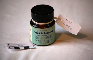
Manufactured Glass, brown bottle 'Penicillin Lozenges', 20thC
F. H. Faulding & Co was a pharmaceutical company founded in Adelaide, South Australia in 1845 by Francis Hardey Faulding 1816 – 1868, a native of Swinfleet, Yorkshire, He arrived in Sydney on the Nabob in February 1842,and travelled on the brig Dorset to Adelaide in May, where he opened a pharmacy at 5 Rundle Street in 1845.The pharmacy flourished, so he purchased a warehouse in Clarence Place in the city and transferred the manufacturing and wholesale arms of the business there. In 1861 he entered into partnership with Luther Scammell (1826–1910).a Yorkshireman, who had received medical training at Guy's Hospital, and arrived in Adelaide in 1849. Faulding died in 1868 and Scammell took over the business, however he was forced to retire in 1889 when the Bank of Adelaide threatened foreclosure after a series of failed mining and pastoral speculations. Two of his sons, Luther Robert Scammell FCS LSA ( 1858 – 1940) and William J. Scammell ( 1856 – 1928) acquired the manufacturing and wholesaling operations, and the business name, in 1888; the retail shops were sold to reduce the debt to the bank.The company expanded under the two brothers and later two sons of each became directors of the company. In June 1921 Faulding & Co. became a private company, with L.R. Scammell as chairman and managing director. He continued to run the firm's affairs until 1935.Two of the Faulding company's major innovations were the development of a process for distillation of eucalyptus oil, and the development of the test for determining the eucalyptol content of the oil. Faulding's success was founded on eucalyptus oil, which formed the basis of an antiseptic marketed as "Solyptol" (for soluble eucalyptus oil). The test became the industry standard, and the British Pharmacopoeia standard method in 1898. Other well-known products were Milk Emulsion (a pleasant alternative to cod-liver oil), Solyptol Soap, (which won a gold medal at the Franco-British Exhibition in London in 1908), Solyptol disinfectant, junket tablets, cordials, essential oils for perfumery and reagents such as Epsom salts, most produced in its factory in Thebarton The Faulding Co. built success around optimising the delivery of oral dosage form drugs. A brown glass bottle with a plastic screw top that contained 'Penicillin Lozenges' made by F.H. Faulding Co. Ltd . AustraliaFAULDING / Penicillin Lozenges / ( Troch. Penicillin B.P.) /......... / F.H.Faulding & Co. Ltd. / Adelaide, Perth, Sydney, / Melbourne, Brisbane on back DIRECTIONS......pharmacy, medicines, f.h. faulding co. ltd, penicillin lozenges, antibiotics, dentists, glassware, bottles, moorabbin, bentleigh, cheltenham -
 City of Moorabbin Historical Society (Operating the Box Cottage Museum)
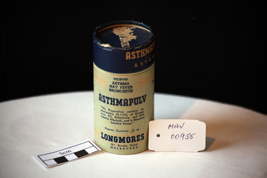
Containers, cardboard, ‘Longmores’ ‘Asthmapulv’, mid 20thC
Longmore’s was a manufacturing chemical pharmacy of many over-the-counter preparations, including Sulphur Hair Restorer, Strengthening Tonic, Blood and Liver Pills, Asthmacur (for asthma) and Hoyle’s Miraculous Oil (for miracles unknown), He was a native of New South Wales, but his father, Mr. Joseph Longmore settled in Melbourne in the late 1850s. Mr Longmore was educated at the Melbourne Grammar School, and leaving early, he studied and qualified as a chemist. Argus “12 October 1921, Mr. Francis Longmore, chemist of Bourke Street was at his business on Saturday but he had a chill which developed into pneumonia, and he died yesterday morning. The funeral will leave from his residence Wontravell, Gower Street, Kensington. He was a widower, his wife having died a year ago and he leaves a grownup family of 2 sons and 6 daughters. Carlisle Francis Longmore and his certificate number as a pharmacist was No. 1440; he qualified as a pharmacist at his final exam in Victoria on 11 September 1905. He had three pharmacies in addition to the address on the covers, one on the corner of Flinders and King Streets, Melbourne, one at 130 Bourke Street East and one Brunswick Street, North Fitzroy. He also had another sideline in addition to his pharmaceuticals and this was White Crow Jelly Crystals made at his Food Products division in Melbourne A cardboard cylindrical container with a lift-off lid for 'Longmores Asthmapulv'.Lid ASTHMAPULV. Around Lid ASTHMAPULV /FOR / ASTHMA Relieves/ ASTHMA / HAY FEVER / BRONCHITIS / ASTHMAPULV / "This preparation contains......... labelled Poison" / Approx. Contents 3 1/2 oz. / LONGMORES / 361 Bourke Street / MELBOURNE / For Inhalation Only / DIRECTIONS ................ / Invaluable in severe cases of Asthma. ......... / (Patent Medicine) Act 1942........* pharmacy, medicines, longmore c.. francis, longmore joseph, asthma, hospitals, nursing, containers, moorabbin, bentleigh, cheltenham, melbourne -
 City of Moorabbin Historical Society (Operating the Box Cottage Museum)
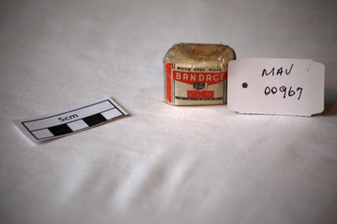
Bandage, cotton, mid 20thC
A bandage is a piece of material used either to support a medical device such as a dressing or splint, or on its own to provide support to the body; it can also be used to restrict a part of the body. G. J. Coles opened the 'Coles Variety Store' on 9 April 1914 on Smith Street in the Melbourne, Victoria suburb of Collingwood. Further expansion occurred and Coles' interest in food retailing was spurred in 1958 when it acquired 54 John Connell Dickins grocery stores. It then acquired the Beilby's chain in South Australia in 1959 and 265 Matthews Thompson grocery stores in New South Wales in 1960 .In 1960, the first supermarket was opened in the Melbourne suburb Balwyn North, at the corner of Burke and Doncaster Roads where a modernised version continues to operate. By 1973, Coles had established stores in all Australian capital cities. From 1962, its supermarkets were branded Coles New World with accompanying rocket imagery. In 1991, the stores were re-branded Coles Supermarkets and from 1998, simply as Coles. George James (G. J.) Coles learned the retail trade working for his father's 'Coles Store' business from 1910 to 1913. The store continued operating as "The Original Coles" at Wilmot, Tasmania until it was destroyed by a fire on 24 January 2014. An unused, 1 inch ( 2.5cm ) x 6 yards ( 2metres) cotton, ‘open wove’ bandage in a cellophane wrapper sold by G.J. Coles Pty Ltd Variety StoresCellophane wrapper top: WHITE OPEN WOVE / BANDAGE / 1 X 6 YDS. / SPECIAL QUALITY / G.J.COLES * pharmacy, medicines, bandages, wounds, early settlers, market gardeners, moorabbin, bentleigh, cheltenham, cotton, gauze, coles g j pty ltd., variety stores, supermarkets, smith street collingwood, retailers, shops -
 City of Moorabbin Historical Society (Operating the Box Cottage Museum)
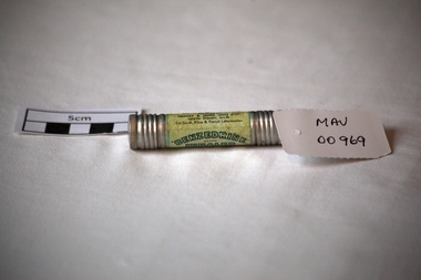
Containers, metal cylindar 'Benzedrine ' inhaler, mid 20thC
An Inhaler helps to ease breathing and provides relief from a stuffy nose caused by colds and allergies. An empty metal cylinder with screw top containing ‘Benzedrine’ inhalation’BENZEDRINE’./ BRAND / INHALER / FOR RELIEVING NASAL CONGESTION / Each tube is packed with /……… / Remove both ends , insert tapered /end well into nostril / …….. Effectiveness gradually decreases / with use / ….Distributed by / MENLEY&JAMES (Col) LTD / NORTH SYDNEY N.S.W. / For Smith, Kline & French Laboratories pharmacy, medicines, asthma inhalers, respiratory diseases, early settlers, market gardeners, moorabbin, bentleigh, cheltenham, benzedrine, sydney, new south wales, menley & james (col) ltd., smith, kline & french pty ltd -
 Greensborough Historical Society
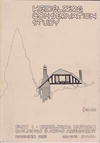
Book, Heidelberg Conservation Study: Part 1 Historic Buildings and Areas Assessment, 1985_
Report prepared by Graeme Butler on behalf of City of Heidelberg and Heidelberg Heritage Advisory Committee. Area covered is from Eaglemont in the south to Macleod in the north.This study identifies neighbourhood character, documents past development and the capacity of the environment for future development.Part one of set of three books. Paperback, 189 pages, Illus., maps. 2 copies.Stamps: Yarra Plenty Regional Library Service, and, Withdrawnheidelberg, macleod, heidelberg heritage advisory committee, graeme butler, plenty river, eaglemont -
 Greensborough Historical Society
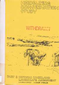
Book, Heidelberg Conservation Study: Part 2: Historic Riverland Landscape Assessment. Revised 1987, 1987_
Report prepared by Loder and Bayly and Marilyn McBriar on behalf of City of Heidelberg and Heidelberg Heritage Advisory Committee. Area covered is from Darebin Parklands in the south to Plenty River at Yallambie in the north. Revised 1987.This study identifies neighbourhood character, documents past development and the capacity of the environment for future development with particular emphasis on the river precincts - Plenty River, Yarra River and Darebin Creek.Part three of set of three books. Paperback, 333 pages, Illus., maps. 2 copies.Stamps: Yarra Plenty Regional Library Service, and, Withdrawnheidelberg, macleod, heidelberg heritage advisory committee, marilyn mcbriar, plenty river, yarra river, darebin creek -
 Eltham District Historical Society Inc
Photograph, Doug Orford, Completion of bridge works across Yarra River at rear of Eltham Lower Park, August 2004
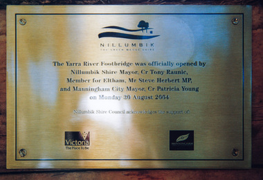
Plaque commemorating the opening of the Yarra River Footbridge opened by Nillumbik Shire Mayor Cr. Tony Ranuic, Member for Eltham, Mr Steve Herbert MP, and Manningham City Mayor, Cr. Patricia Young on Monday 30 August 2004. Nillumbik Shire Couuncil acknowledges the support of the Victorian State Government and City of Manningham. The footbridge links the Diamond Creek Trail between the Shire of Nillumbik and City of Manningham. It is a shared pathway and also links with the Main Yarra Trail. It affords lovely views over the Yarra River.One of three colour photographsbridges, yarra river, eltham south, eltham lower park, lenister farm, homestead road, plaque, yarra river footbridge, steve herbert, tony ranic, patricia young -
 Eltham District Historical Society Inc
Photograph, Doug Orford, Completion of bridge works across Yarra River at rear of Eltham Lower Park, July 2004
Bitumen shared pathway under construction at the new Eltham-Templestowe footbridge over the Yarra River off Homestead Road, Eltham which was completed in July 2004. The Yarra River Footbridge was opened in August 2004 and links the Diamond Creek Trail between the Shire of Nillumbik and City of Manningham. It is a shared pathway and also links with the Main Yarra Trail. It affords lovely views over the Yarra River.Three colour photographs showing commencement of construction of Eltham-Templestowe footbridge over Yarra River off Homestead Road, Eltham which was completed July 2004. Third photograph of dedictaion plaque at opening 30 Aug 2004bridges, yarra river, eltham south, eltham lower park, lenister farm, homestead road, asphaldt, bitumen, shared pathway, diamond creek trail -
 Eltham District Historical Society Inc
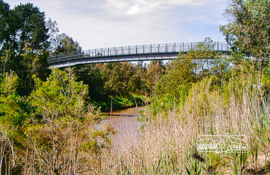
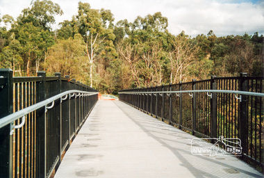
Photograph, Footbridge across the Yarra River at Eltham Lower Park
The Yarra River Footbridge was opened in August 2004 and links the Diamond Creek Trail between the Shire of Nillumbik and City of Manningham. It is a shared pathway and also links with the Main Yarra Trail. It affords lovely views over the Yarra River.Colour photographbridge, eltham lower park, eltham south, homestead road, lenister farm, yarra river, footbridge, lookout, diamond creek trail -
4th/19th Prince of Wales's Light Horse Regiment Unit History Room
Regimental Scrap Book: 1990-1999, 2009
Archival quality A3 loose leaf slip case containing memorabilia documents, cuttings and photos about the Regiment for the period 1990-1999. Contents include:Training, Ceremonial, social activities. Hansard 18 Oct 1990 re future of the Regiment. Threats to the Regiment. Chief of General Staff Commendation to A Squadron 4/19 PWLH for assistance with flood emergency in Gippsland April 1990. Meritorious Unit Commendation to Prince of Wales Light Horse Troop while attached to 173 US Airborne Brigade, South Vietnam 1965/66. Freedom of City of Melbourne May 1992. 50th Birthday of Regiment. Closure of Traralgon Depot 1998.ceremonial, training, vietnam war, history 4 19 prince of wales s light horse, freedom of city melbourne, freedom of city traralgon, traralgon army depot, commendations, gippsland floods -
 4th/19th Prince of Wales's Light Horse Regiment Unit History Room
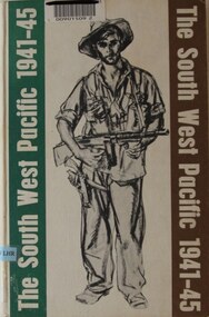
Book, Colonel E G Keogh M.B.E., E.D, The South West Pacific 1941-45, 1965
A book on war in New Guinea and Islands providing a detailed overview of Australian forces participation in the Battle for Australia. Concise for Kokoda and Milne Bay including copy of battle maps, but also covers Singapore, Borneo, Philippines, Wewak and Bougainville, and more.Hard covered book, 479 pages, WW11 Australian soldier on front cover bearing sub-machine gun and pistolnon-fictionA book on war in New Guinea and Islands providing a detailed overview of Australian forces participation in the Battle for Australia. Concise for Kokoda and Milne Bay including copy of battle maps, but also covers Singapore, Borneo, Philippines, Wewak and Bougainville, and more.history, world war 2, south west pacific, keogh -
4th/19th Prince of Wales's Light Horse Regiment Unit History Room
Photograph, est late 1800's
A photo of a large contingent of mounted soldiers parading through the streets of a city. The uniforms indicate the South African War era. It could be a farewell parade, with many citizens on each side of the street. There is indication of location.Nilphoto, colonial era, photo, colonial era -
 Kiewa Valley Historical Society
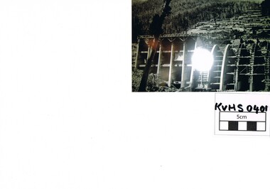
Photograph Junction Dam, Photo Junction Dam and Bogong Village in Background, circa 1950s
This item clearly shows the conditions covering both working conditions and housing in the construction of the Junction Dam in the 1940s. Working conditions were extreme and health and safety legislation was at its infancy. The residential buildings were intended to last only for the period of construction, however greater demand for longevity as a tourist haven prevailedThis photo of the construction of the Junction Dam, with The Bogong village as backdrop, details the harsh conditions faced by construction workers, building dams and villages to accommodate workers in the 1940s to the 1950s. Australia at this period in time, experienced a surge of population (influx of World War II refugees), which was the catalyst for developing and undergoing an enormous hydroelectricity program for the Alpine regions, both in Victoria and New South Wales. This program was initiated to supply electricity to the major southern Australian cities of Adelaide, Melbourne and Sydney. It was thought that these developments would reduce, if not eliminate, the requirement for coal driven power stations. However time has demonstrated that these power stations have not matched the demand required by the industries and the populations of the major urban and cities.Black and white photo of original photo with a flashlight reflection in the bottom centre. The photo is on Kodak XtraLife II paper. The paper is semi gloss.This photo is of the construction of the Junction Dam Wall with the Bogong Townshiip in the background.Back of photo is printed " Kodak XtraLite II paperdam construction, bogong village, alpine development, junction dam -
 Eltham District Historical Society Inc
Photograph, Doug Orford, Completion of bridge works across Yarra River at rear of Eltham Lower Park, July 2004, July 2004
Brand new Eltham-Templestowe footbridge over the Yarra River off Homestead Road, Eltham which was completed in July 2004. The Yarra River Footbridge was opened in August 2004 and links the Diamond Creek Trail between the Shire of Nillumbik and City of Manningham. It is a shared pathway and also links with the Main Yarra Trail. It affords lovely views over the Yarra River.One of three colour photographs.yarra river, eltham south, eltham lower park, lenister farm, homestead road, shared pathway, diamond creek trail, footbridge -
 Warrnambool and District Historical Society Inc.
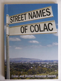
Book, Streets of Colac, 2008
This is a book giving information on the streets of Colac and the origins of the names. Colac is a city 150 kilometres south west of Melbourne and is a commercial centre for a major agricultural area. It is situated near the 3rd largest volcanic plain in the world and European settlement began in 1837. The book was commenced by Ian McIntosh in the 1970s and in 2005 the Colac and District Historical Society took on the project again with the major editors being Ida and Andrew McIntosh. This book is of interest, particularly those in the Western District of Victoria, as it contains information on Colac streets, many of which were named after pioneers of the district. The book will be useful for research. This is a soft cover book of 60 pages. The cover has a blue background and features a colour photograph (mainly in green, blue and white tonings) of a panorama of the Colac district. The photograph extends over the front and back covers. The book contains the names and name origins of Colac streets in alphabetical order and many black and white photographs. The pages have a glued binding. Front Cover: ‘Street Names of Colac’ ‘Colac and District Historical Society’ history of colac, colac and district historical society, street names of colac, ian mcintosh -
 Warrnambool and District Historical Society Inc.
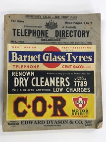
Book, Telephone Directory Melbourne May 1933, 1933
This is a telephone directory of the telephone numbers and addresses of residents and businesses in Melbourne in 1933. There had been several early attempts in the second half of the 19th century to link places and homes in Victoria by locally-made telephone systems with a commercial telephone system in the same year successfully linking a business in Melbourne to a branch office in the same city. The first telephone exchange in Australia was established in Melbourne in 1880. This 1933 telephone directory shows the growing number of private residents and businesses to have the telephone installed but the installations were still confined mostly to the more affluent private residents and to businesses. This book is of considerable interest as a reference guide as it provides the names and addresses of those who had a telephone installed in Melbourne in 1933. This will be of great use to researchers, especially those compiling their family tree. This is a soft cover book of 364 pages. It has a buff-coloured cardboard cover with the title and other printed information on the front cover and four multi-colour advertisements for Melbourne businesses (Barnet Glass Tyres, Renown Dry Cleaners, C.O.R. Motor Spirit and Edward Dyason, Sharebrokers), also on the front cover. The back cover has a colour advertisement for Gilbey’s Gin. The pages listing the householders’ telephone numbers and addresses in alphabetical order are white with black printing and there are 20 pink pages at the back (business and professional listings). The book has been bound with glue. The cover is somewhat crumpled and the pages are dog-eared. melbourne history, telephone installation history in victoria, warrnambool, history -
 Warrnambool and District Historical Society Inc.
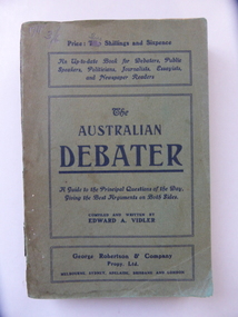
Book, The Australian Debate, Early 20th century
This book has been written by Edward Vidler (1863-1942), a publisher, editor, writer and journalist. He was born in England and was in Geelong in the 1880s where he produced a commemorative volume on that city. He was living in Warrnambool in the early years of the 20th century and was the Secretary of the Warrnambool and District Progress League and the Warrnambool Chamber of Commerce and Industry. He later lived in Melbourne where he edited magazines and published his own and other writings. He was especially interested in the promotion of the arts and was a keen naturalist. He was a foundation member of the group that established the Maranoa Native Gardens in Balwyn, Melbourne. The writer of this book, Edward Vidler, was important in the history of Warrnambool for two main reasons:- 1. In 1907 he initiated and organized the establishment of the Warrnambool Pioneer Honour Board featuring portraits of 204 pioneer men. This board still exists. 2. In 1907 he produced a publication called ‘Warrnambool Past and Present – Sixty Years of Progress’. It celebrated the 60th anniversary of the founding of Warrnambool and contained 88 pages, 120 illustrations and photographs and many advertisements. The publication is noted for its historical accuracy, the way it complements and adds to Richard Osburne’s 1887 history of Warrnambool and its presentation of historical material that may otherwise have been lost. Both of Vidler’s initiatives described above are of the utmost importance in Warrnambool’s history. This is a soft cover book of 270 pages. The cover is green with black printed material on the covers and the spine. The book has a Preface, 24 chapters of text and a Bibliography. There are advertisements for other books on the last page and the back cover. The cover is stained and faded and partly torn in places and some of the inside pages are stained. The Australian Debateredward vidler, history of warrnambool -
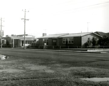 Victoria Police Museum
Police Stations (Altona)
Altona is a suburb of Melbourne, 13 km south-west of Melbourne's CBD and located within the City of Hobsons Bay Altona Police Station opened as a temporary police station in 1919 in the Melbourne District. It was on the corner Sargood and Blyth Streets. It was staffed by one 1st Constable. The original police station was in a small room attached to the front of a 5-roomed weather-board dwelling with an iron roof on land measuring 66' x 165'. There was also a kitchen, vestibule, wash-house, office, one W.C. and a lock-up. In 1929 it became part of the Bourke District. On 31 March 1958 it moved into newly built government premises at 51-53 Blyth Street, on the corner of Bent Street. The building consisted of a cream brick veneer police residence and police station with cell. Staff was increased to a Sergeant in Charge and 3 Constables. A new police station was opened in Altona North on 7th October 1979. The Altona Police Station remained as a sub-station for a few a short time until the building was sold. July 2019 - a new police station is being constructed at 1 Galvin Street, Altona. Galvin Street was names after S/C Michael Arthur Galvin, 3651, who was appointed on 5 Jan 1886 and resigned on 4 Dec 1913. He was Werribee Shire President 1926-1927 and 1940-1941 8 black and white photos of new police station, 1963police stations; altona police station -
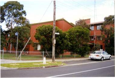 Victoria Police Museum
Police Stations (Altona North)
Altona North is a suburb of Melbourne, Victoria, Australia, 10 km south-west of Melbourne's Central Business District, located within the City of Hobsons Bay local government area. Altona North Police Station opened on 7 October 1979 as a new twenty-four police station and was the District Headquarters of Altona District. It comprised a C.I.B. and a Community Policing Squad. It is located at 72 Cooper Avenue, on the corner of McArthurs Road. A new police station is being planned for Galvin Street, opening in 2020.2 colour photospolice stations; altona north police station -
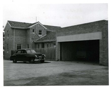 Victoria Police Museum
Police Stations (Ararat)
Ararat is a city in south-west Victoria, Australia, about 198 kilometres west of Melbourne, on the Western Highway on the eastern slopes of the Ararat Hills and Cemetery Creek valley between Victoria's Western District and the Wimmera. It is named after Mount Ararat 10 kilometres south-west of the town. A police station opened in Ararat in 1859, though there was a police presence in the area formerly known as Cathcart, Canton Lead and later Mount Ararat. In 1861 staff consisted of 1 Superintendent, 2 Mounted Constables, 1 Sergeant 2nd class, 1 Senior Constable, 8 Constables. The police reserve was on land bounded by Ligar Street, Barkley Street, Ingor Street and High Street. In 1930 the police station was described as a six-room brick dwelling with a slate roof, situated on one quarter acre of land. There was also a bathroom, wash-house, pantry, office, muster room and quarters for a single constable, stables with three stalls, and a lock-up consisting of two six-person cells. Later residences were located at 3 Ligar Street (brick veneer with a tile roof); 32A High Street (brick veneer with tile roof); and 3 Tobin Street (wood with an iron roof). A new, purpose built police station was opened in October 2010 at 77 Barkly Street. The Ararat Police District was reformed into the Wimmera Police District in 1870. Ararat Police Station became part of "R" (Glenelg) District in January 1948 and "M" (Highlands/Wimmera) District from March 1990. A list of police stationed at Ararat from 1903 - 1930 is available from the Victoria Police Museum8 photos comprising: 7 black & white photos 1 colour photopolice stations; ararat police station -
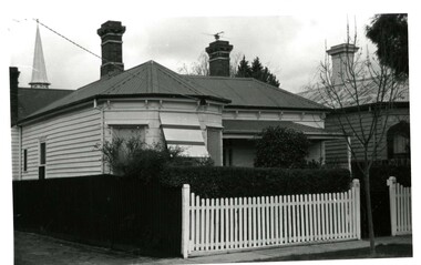 Victoria Police Museum
Police Stations (Armadale)
Armadale is an inner suburb of Melbourne, Victoria, Australia, 7 km south-east of Melbourne's Central Business District, located within the City of Stonnington local government area. Armadale Police Station opened, in Melbourne Police District, on 11 May 1885. Its original location is unknown, but in 1890 it is listed in the Sands & McDougall directory as at 295 Hight Street. From 1985-1920 it was located at 20/22 Auburn Grove, 1925-1930 at 769 High Street and 1935-1946 at 3 Cheel Street. The station closed on 28 January 1946. The sub-division east of Orrong Rd was incorporated into Malvern Sub-district and west of Orrong Road into Prahran Sub-district. In a special 1930 issue of the Victoria Police Gazette the Armadale Police Station was described as a seven-roomed brick dwelling with a tiled roof on land measuring 127' x 104' x 98'. There was also a bathroom and W.C., a wash-house, office, and a lock-up (one cell). This is probably a description of the Cheel Street police station. It was staffed by one senior constable and three foot constables.12 photographs comprising 8 coloured images and 4 black and white images 1 sketch plan of Old Armadale Police Stationpolice stations; armadale police station