Showing 137 items matching "walls album"
-
 Ballarat Tramway Museum
Photograph - Black & White Photograph/s, Keith Kings, 12/02/1966 12:00:00 AM
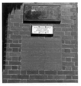
Black and White photograph contained with Reg. Item 1902 - Photo Album from Keith Kings to Les Denmead 1970. Photograph on AGFA paper of the ESCo foundation stone and SEC office plaques on the wall of the Wendouree Parade Offices of the SECV, 12/2/1966. Keith Kings No. N(o)(13) Scanning: i - image file, p - presentation file, b - back of photograph.Stamp in top left hand corner and handwritten number with "K.S. Kings No. N(o)(13), Copyright reserved". In blue ink "Ballarat (1) Foundation Stone for Power House and offices of the Electric Supply Co. of Vic. Ltd. (2) S.E.C. of Victoria plate. (3) E.S.D. plate of SEC Wendouree parade 12/2/66"trams, tramways, secv, foundation stone, plaques, power station, esco -
 Ballarat Tramway Museum
Photograph - Black & White Photograph/s, Keith Kings, 7/03/1958 12:00:00 AM
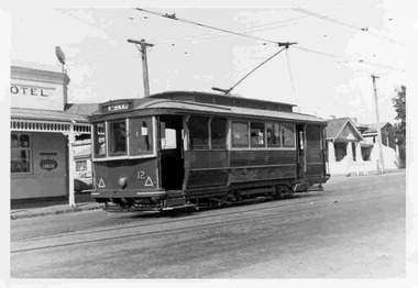
Black and White photograph contained with Reg. Item 1902 - Photo Album from Keith Kings to Les Denmead 1970. Photograph of SEC Bendigo tram No. 12 at Golden Square terminus with the Golden Square hotel in the background. Has a "Fosters Lager sign" on the wall. Tram has destination of "Nth Bendigo". Photo taken 7/3/1958. Keith Kings No. A(d)(15) Scanning: i - image file, p - presentation file, b - back of photograph.Stamp in top left hand corner and handwritten number with "K.S. Kings No. A(d)(15) Copyright reserved". In blue ink "Bendigo / No.12 / As converted for "One Man" operation / Golden Square terminus 7/3/58"trams, tramways, golden square, bendigo, tram 12 -
 Ballarat Tramway Museum
Photograph - Black & White Photograph/s, Keith Kings, Geelong 28 on depot fan, 21/08/1955
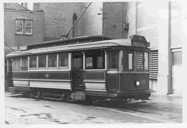
Photograph of SEC Geelong, No 28 on the depot fan, 21/8/1955. Tram showing the destination of "City". Has depot buildings and power station walls in the background. See item 8879 for a colour version. Keith Kings No. P(e)(4)Black and White photograph contained with Reg. Item 1902 - Photo Album from Keith Kings to Les Denmead 1970. Stamp in top left hand corner and handwritten number with "K.S. Kings No. P(e)(4) Copyright reserved". In blue ink "Geelong / No. 28 / Ex-Melbourne car, as altered for "one-man" operation / Depot / 21/8/55".trams, tramways, geelong, depot, tram 28 -
 Ballarat Tramway Museum
Photograph - Digital image, Alwyn Marshall, 1960
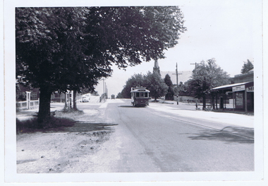
Yields information about the appearance of No. 32, Lydiard St North and Macarthur St intersection in 1960.Digital image from the Wal Jack Ballarat Album of a photograph of No 32 southbound in Lydiard St at the intersection with Macarthur St. Has a Milk Bar - shop on the right hand side and the photograph shows the cutting wall on the east side of the street after the intersection. Photo by Alwyn Marshall. Possibly printed by Wal Jack as it has his handwriting on the rear. See image i2 for rear of photograph.On rear of photograph in ink "SEC, Ballarat No. 32 to Sebastopol in Lydiard St Nth at Macarthur St 1960 A. Marshal Photo."trams, tramways, lydiard st nth, macarthur st, tram 32 -
 Ballarat Tramway Museum
Photograph - Black & White Photograph/s, Wal Jack, 6/01/1963 12:00:00 AM
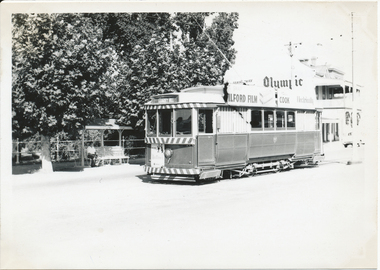
Black and White print contained within the Wal Jack Bendigo and Geelong Album, see Reg Item 5003 for more details. Photo of the Bendigo 7 at Eaglehawk 6-1-1963. Wal's album notes note that the tram ex Ballarat No. 19. The tram has the destination of Eaglehawk and has advertisements for Ilford Film and Electricity cooking on roof and Hutton's ham on rear drivers dash panel. In the background is the Park Hotel with the wall painted for Beaurepaires Olympic tyres. Printed on Ilford Paper. i1 - scan of print in the album i2 - rear of image i3 - scan of negative at 3200dpi added 6/6/2020. On the rear in blue ink "SEC Bendigo, 3rd No. 7 ex Ballarat No. 19. Eaglehawk, 6-1-63" with Wal Jack copyright stamp in the top right hand corner and the number "T1311" written in.trams, tramways, bendigo, eaglehawk, tram 7 -
 Kew Historical Society Inc
Photograph, Veranda, Kew Mental Hospital, 1954, 1954
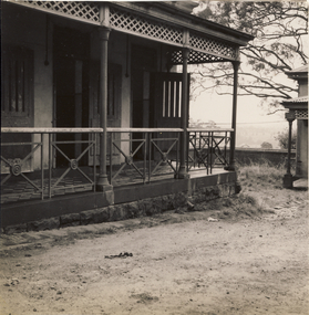
This photograph is one of approximately 43 original photographs and photocopies of buildings, patients and staff assembled in a red covered, spirally bound photograph album (the album itself is now discarded and the images stored separately). The images in the album cover the period from the 1870s to 1965. A few photographs have inscriptions on the reverse; others had later separate labels in the album. The album was presumably compiled as a public record. It and other items came from the collection assembled by Dr Fred Stamp, the last medical superintendent of Willsmere Hospital before its closure in 1988. Original photographs have been uploaded to and described on Victorian Collections. The album itself is listed and linked separately showing the photographs in situ.A number of the photographs from the Willsmere Hospital album are confronting, especially given the condition of the buildings and facilities depicted, as well as the casual photographs of patients, which some viewers may find distressing. The album and its photographs are however an historically significant visual record of the Kew Mental Hospital, especially in the years 1951-1965.Black and white photograph of the edge of a veranda in the Kew Mental Hospital. What appears to be a HaHa! wall can be seen in the distance"1954"kew lunatic asylum, kew hospital for the insane, kew mental hospital, kew mental institute, willsmere mental hospital, willsmere hospital -
 Kew Historical Society Inc
Photograph - Construction of Maroondah Dam, c.1926
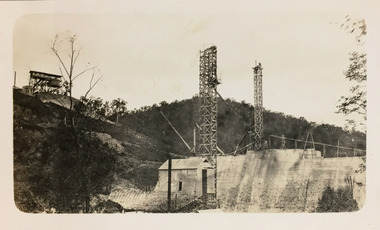
Henry Beater Christian (1886-1962) , was a descendant of one of the earliest settler families in Kew. Employed at the Kew Asylum as a 'public servant', he was a skilled amateur photographer, photographing numerous scenes in Kew and on his travels around Victoria. The majority of his photographs date from 1916 to 1929. His finest photographs are housed in two photograph albums. Digital copy of a photograph from page 22 of the 47-page photograph album containing 261 gelatinous silver images, loaned by Diane Washfold with given to digitise and hold a copy in our collection. This photograph, dating from the 1920s, shows a dam wall being constructed. The dam is probably the Maroondah Dam which was built by the MMBW in the 1920s. henry beater christian (1886-1962), landscape photography, christian-washfold collection, photograph albums, water catchments -- melbourne (vic.), dam walls, maroondah dam -
 Kew Historical Society Inc
Photograph - Construction of Maroondah Dam, c.1926
Henry Beater Christian (1886-1962) , was a descendant of one of the earliest settler families in Kew. Employed at the Kew Asylum as a 'public servant', he was a skilled amateur photographer, photographing numerous scenes in Kew and on his travels around Victoria. The majority of his photographs date from 1916 to 1929. His finest photographs are housed in two photograph albums. Digital copy of a photograph from page 22 of the 47-page photograph album containing 261 gelatinous silver images, loaned by Diane Washfold with permission given to digitise and hold a copy in our collection. This photograph, dating from the 1920s, shows a dam wall being constructed. The dam is probably the Maroondah Dam which was built by the MMBW in the 1920s. henry beater christian (1886-1962), landscape photography, christian-washfold collection, photograph albums, water catchments -- melbourne (vic.), dam walls, maroondah dam -
 Kew Historical Society Inc
Album, Dorothy Rogers, Newspaper Articles : Eastern Suburbs Standard, 1964
This work forms part of the collection assembled by the historian Dorothy Rogers, that was donated to the Kew Historical Society by her son John Rogers in 2015. The manuscripts, photographs, maps, and documents were sourced by her from both family and local collections or produced as references for her print publications. Many were directly used by Rogers in writing ‘Lovely Old Homes of Kew’ (1961) and 'A History of Kew' (1973), or the numerous articles on local history that she produced for suburban newspapers. Most of the photographs in the collection include detailed annotations in her hand. The Rogers Collection provides a comprehensive insight into the working habits of a historian in the 1960s and 1970s. Together it forms the largest privately-donated collection within the archives of the Kew Historical Society.A scrapbook compiled by the historian Dorothy Rogers comprised largely of 15 articles that she wrote for the Eastern Suburbs Standard between January and August 1964. Only one of the articles has additional typed material that was cut at the time of publication. The author notes that the scrapbook is covered with wall paper from her now demolished family home.dorothy rogers, local history (kew), newspapers -- eastern suburbs standard -
 Wodonga & District Historical Society Inc
Album - Hume Reservoir Australia Album - Detail plan and explanation, Department of Public Works, N.S.W, 1927
This set of photos is from a leather bound album bearing the inscription "HUME RESERVOIR AUSTRALIA" plus 'The Rt. Hon. L. C. M. S. Amery, P. C., M .P.' all inscribed in gold. It was presented to The Rt. Hon. L. C. M. S. Amery, P. C., M. P, Secretary of State for Dominion Affairs on the occasion of his visit to the Hume Reservoir on 2nd November 1927. This album is of local and national significance as it documents the planning and development of the Hume Reservoir up to 1927. It was the largest water reservoir in the British Empire. The album records the pioneering engineering work that went into its construction.2. Detail Plan and Section. Starting from the New South Wales and there will be an earthen embankment 430 feet 6 inches long which is retained by the North Wing Wall. Then come the sluice section 284 feet 3 inches long, the spillway 720 feet long and the South Wing Wall, making a total length of 1,042 feet 6 inches of concrete wall. Beyond the South Wing Wall is earth embankment again to a length of 3,827 feet. The Full Supply Level is R.L.626.00 and allowance has been made for a surcharge of 9 feet. A road will run along the top of the dam at R.L.642.00. The sluice section contains seven offlets, the three nearest the north wing wall being 13 feet in diameter for hydro-electric purposes and the other four 9 feet in diameter for regulation purposes only. There are to be stony sluice gates on the upstream ends of the outlets and needle valves on the downstream ends. The shock of the discharged water will be taken by a stilling pool. Trash racks will protect the intake ends of the outlets. Next comes the spillway section, which is curved on the downstream face, and carried up to within 15 feet of the full supply level. Above that will be a series of piers between which will be the flood gates and on top of which the roadway will be carried. The gates will be 20 feet wide and 15 feet high and will be 29 in number. They will slide down the face of the wall when opened for the escape of the water. The investigation of the control of this cascade of water was made by means of a model and as a result the form of “bucket” or energy dissipater shown on the section of the spillway was decided upon. The earth embankment in Victoria is being constructed by the State Rivers and Water Supply Commission of Victoria who are the Constructing Authority for that State under the River Murray Waters Agreement. The core of the embankment is of concrete 6 feet wide at the base tapering to 2 feet at the top end and is reinforced with steel rods from the level of the decomposed rock upwards. On the downstream side, at about natural surface level, is a tunnel for drainage and inspection purposes. Above the tunnel is a vertical layer of large stones to drain any seepage to the tunnel. Against the core wall is packed selected material of as impervious a character as can be got locally and beyond that the bank is carefully built up in horizontal layers by means of horses and wheel scoops. The upstream slope is 3-to-1 hardening to 2½-to-1 at the top and the downstream slope is 2½-to-1 hardening to 2.07-to-1 at the top. The thrust of the upstream toe is taken by a mass of granite blocks, and this face is protected by concrete laid in situ. The width of the bank at base is 650 feet and at top 32 feet.hume reservoir australia, river murray waters scheme, hume weir diagrams, hume plan details -
 Wodonga & District Historical Society Inc
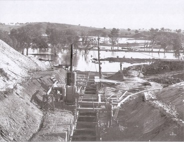
Album - Hume Reservoir Australia Album - Foundations for core wall of earth embankment, September 1921
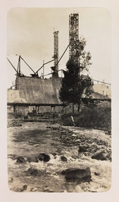
... Hume Reservoir Australia Album - Foundations for core... Hume Reservoir Australia Album - Foundations for core wall ...This set of photos is from a leather bound album bearing the inscription "HUME RESERVOIR AUSTRALIA" plus 'The Rt. Hon. L. C. M. S. Amery, P. C., M .P.' all inscribed in gold. It was presented to The Rt. Hon. L. C. M. S. Amery, P. C., M. P, Secretary of State for Dominion Affairs on the occasion of his visit to the Hume Reservoir on 2nd November 1927. This album is of local and national significance as it documents the planning and development of the Hume Reservoir up to 1927. It was the largest water reservoir in the British Empire. The album records the pioneering engineering work that went into its construction.DEPARTMENT OF PUBLIC WORKS, N.S.W. RIVER MURRAY WATERS SCHEME. HUME RESERVOIR. 5. Foundations for core wall of earth embankment in New South Wales in September 1921. The River Murray in flood.hume reservoir australia, river murray waters scheme, hume weir diagrams, hume plan details -
 Wodonga & District Historical Society Inc
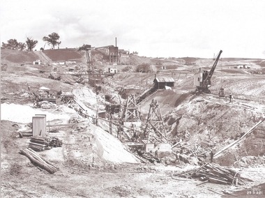
Album - Hume Reservoir Australia Album - Excavation for Foundations of Core Wall September 1922
This set of photos is from a leather bound album bearing the inscription "HUME RESERVOIR AUSTRALIA" plus 'The Rt. Hon. L. C. M. S. Amery, P. C., M .P.' all inscribed in gold. It was presented to The Rt. Hon. L. C. M. S. Amery, P. C., M. P, Secretary of State for Dominion Affairs on the occasion of his visit to the Hume Reservoir on 2nd November 1927. This album is of local and national significance as it documents the planning and development of the Hume Reservoir up to 1927. It was the largest water reservoir in the British Empire. The album records the pioneering engineering work that went into its construction.DEPARTMENT OF PUBLIC WORKS, N.S.W. RIVER MURRAY WATERS SCHEME. HUME RESERVOIR. 9. Excavations for foundations of core wall (in foreground) and part of core wall and earth embankment constructed (in background) in Victoria, September 1922.hume reservoir australia, river murray waters scheme, excavation hume reservoir -
 Wodonga & District Historical Society Inc
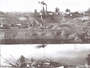
Album - Hume Reservoir Australia Album - View from the Victorian bank of the Murray River, May 1923
This set of photos is from a leather bound album bearing the inscription "HUME RESERVOIR AUSTRALIA" plus 'The Rt. Hon. L. C. M. S. Amery, P. C., M .P.' all inscribed in gold. It was presented to The Rt. Hon. L. C. M. S. Amery, P. C., M. P, Secretary of State for Dominion Affairs on the occasion of his visit to the Hume Reservoir on 2nd November 1927. This album is of local and national significance as it documents the planning and development of the Hume Reservoir up to 1927. It was the largest water reservoir in the British Empire. The album records the pioneering engineering work that went into its construction.DEPARTMENT OF PUBLIC WORKS, N.S.W. RIVER MURRAY WATERS SCHEME. HUME RESERVOIR. 12. View from the Victorian bank of the river showing in the foreground a levee bank along the New South Wales side of the river with connecting wings back to the higher ground, May 1923. The first stage in the construction of the Dam foundations was carried out inside the levee bank which was at a sufficient height to protect from floods the work going on inside. A length of 300 feet of the Dam was left at a low elevation to allow of the river flowing over it in the second stage of the operations and at the ends of the concrete was brought up above flood level. To divert the river, a Coffer Dam was built across the old bed above and below the Dam site and tying into the end of the concrete wall built inside the levee bank. This completely surrounded the remainder of the site of the Dam and south wing wall, including an area of 12½ acres.hume reservoir australia, river murray waters scheme, hume reservoir construction -
 Wodonga & District Historical Society Inc
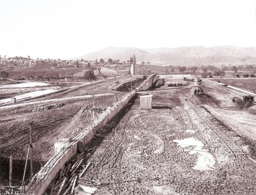
Album - Hume Reservoir Australia Album - Core wall with drainage tunnel and earth embankment in progress in Victoria, June 1924
... Hume Reservoir Australia Album - Core wall with drainage... Album - Core wall with drainage tunnel and earth embankment ...This set of photos is from a leather bound album bearing the inscription "HUME RESERVOIR AUSTRALIA" plus 'The Rt. Hon. L. C. M. S. Amery, P. C., M .P.' all inscribed in gold. It was presented to The Rt. Hon. L. C. M. S. Amery, P. C., M. P, Secretary of State for Dominion Affairs on the occasion of his visit to the Hume Reservoir on 2nd November 1927. This album is of local and national significance as it documents the planning and development of the Hume Reservoir up to 1927. It was the largest water reservoir in the British Empire. The album records the pioneering engineering work that went into its construction.DEPARTMENT OF PUBLIC WORKS, N.S.W. RIVER MURRAY WATERS SCHEME. HUME RESERVOIR. 14. Core wall with drainage tunnel and earth embankment in progress in Victoria, June 1924.hume reservoir australia, river murray waters scheme, hume reservoir construction -
 Wodonga & District Historical Society Inc
Album - Hume Reservoir Australia Album - Driving first row of piles for coffer dam across the river, December 1925
This set of photos is from a leather bound album bearing the inscription "HUME RESERVOIR AUSTRALIA" plus 'The Rt. Hon. L. C. M. S. Amery, P. C., M .P.' all inscribed in gold. It was presented to The Rt. Hon. L. C. M. S. Amery, P. C., M. P, Secretary of State for Dominion Affairs on the occasion of his visit to the Hume Reservoir on 2nd November 1927. This album is of local and national significance as it documents the planning and development of the Hume Reservoir up to 1927. It was the largest water reservoir in the British Empire. The album records the pioneering engineering work that went into its construction.DEPARTMENT OF PUBLIC WORKS, N.S.W. RIVER MURRAY WATERS SCHEME. HUME RESERVOIR. 19. Driving first row of piles for coffer dam across the river. New South Wales. December 1925. Cofferdams are temporary structures used where construction is being carried out in areas submerged in water. They are most commonly used to facilitate the construction or repair of dams, piers and bridges. To divert the river, a Coffer Dam was built across the old bed above and below the Dam site and tying into the end of the concrete wall built inside the levee bank. This completely surrounded the remainder of the site of the Dam and south wing wall, including an area of 12½ acres. hume reservoir australia, river murray waters scheme, hume reservoir construction -
 Wodonga & District Historical Society Inc
Album - Hume Reservoir Australia Album - Section of completed coffer dam, January 1927
This set of photos is from a leather bound album bearing the inscription "HUME RESERVOIR AUSTRALIA" plus 'The Rt. Hon. L. C. M. S. Amery, P. C., M .P.' all inscribed in gold. It was presented to The Rt. Hon. L. C. M. S. Amery, P. C., M. P, Secretary of State for Dominion Affairs on the occasion of his visit to the Hume Reservoir on 2nd November 1927. This album is of local and national significance as it documents the planning and development of the Hume Reservoir up to 1927. It was the largest water reservoir in the British Empire. The album records the pioneering engineering work that went into its construction.DEPARTMENT OF PUBLIC WORKS, N.S.W. RIVER MURRAY WATERS SCHEME. HUME RESERVOIR. 20. Section of completed coffer dam with river diverted over the concrete foundations of dam that were placed during the first stage of operations. New South Wales. January 1927. Cofferdams are temporary structures used where construction is being carried out in areas submerged in water. They are most commonly used to facilitate the construction or repair of dams, piers and bridges. To divert the river, a Coffer Dam was built across the old bed above and below the Dam site and tying into the end of the concrete wall built inside the levee bank. This completely surrounded the remainder of the site of the Dam and south wing wall, including an area of 12½ acres. hume reservoir australia, river murray waters scheme, hume reservoir construction -
 Wodonga & District Historical Society Inc
Album - Hume Reservoir Australia Album - Excavations for foundations inside coffer dam, January 1927
This set of photos is from a leather bound album bearing the inscription "HUME RESERVOIR AUSTRALIA" plus 'The Rt. Hon. L. C. M. S. Amery, P. C., M .P.' all inscribed in gold. It was presented to The Rt. Hon. L. C. M. S. Amery, P. C., M. P, Secretary of State for Dominion Affairs on the occasion of his visit to the Hume Reservoir on 2nd November 1927. This album is of local and national significance as it documents the planning and development of the Hume Reservoir up to 1927. It was the largest water reservoir in the British Empire. The album records the pioneering engineering work that went into its construction.DEPARTMENT OF PUBLIC WORKS, N.S.W. RIVER MURRAY WATERS SCHEME. HUME RESERVOIR. 21. Excavations for foundations inside coffer dam. New South Wales. January 1927. Cofferdams are temporary structures used where construction is being carried out in areas submerged in water. They are most commonly used to facilitate the construction or repair of dams, piers and bridges. To divert the river, a Coffer Dam was built across the old bed above and below the Dam site and tying into the end of the concrete wall built inside the levee bank. This completely surrounded the remainder of the site of the Dam and south wing wall, including an area of 12½ acres. hume reservoir australia, river murray waters scheme, hume reservoir construction, coffer dam -
 Wodonga & District Historical Society Inc
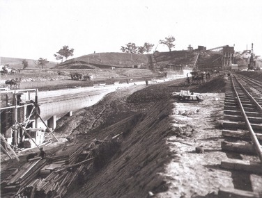
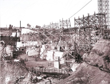
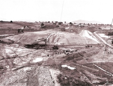
Album - Hume Reservoir Australia Album - General View of Works from New South Wales end, Looking Upstream, August 1927
This set of photos is from a leather bound album bearing the inscription "HUME RESERVOIR AUSTRALIA" plus 'The Rt. Hon. L. C. M. S. Amery, P. C., M .P.' all inscribed in gold. It was presented to The Rt. Hon. L. C. M. S. Amery, P. C., M. P, Secretary of State for Dominion Affairs on the occasion of his visit to the Hume Reservoir on 2nd November 1927. This album is of local and national significance as it documents the planning and development of the Hume Reservoir up to 1927. It was the largest water reservoir in the British Empire. The album records the pioneering engineering work that went into its construction.DEPARTMENT OF PUBLIC WORKS, N.S.W. RIVER MURRAY WATERS SCHEME. HUME RESERVOIR. 22. General View of Works from New South Wales end, Looking Upstream. Features: At the left, part of the North Wing Wall, the highest part of which is 26 feet below its ultimate height. Below in the foreground is the portion of the dam where provision is to be made for hydro-electric generation. The tubes, three in number, 13 feet in diameter, will be laid on the level shown and an early start will be made in laying them. The level for the other four regulating outlets, 9 feet in diameter, together with a part of the spillway section of the dam, is underwater at this stage and it may be remarked that at one point, about half way across the channel where the water is now flowing, the concrete foundations are about 80 feet below the level of the water. The broken surface of the water is due to the large “plums” in the concrete. The still water in the right foreground is the stilling pool over the concrete floor of which there is now more than 20 feet of water and by means of which the discharge from the outlet pipes will be quelled. The trestlework on the upstream side of the dam carries the concrete belt conveyor. It extends from the concrete mixer house, which is out of the picture, behind the wing wall, along almost the entire length of the concrete portion of the dam. The concrete is discharged from the belt at any desired point by means of trippers, one of which may be seen over the second trestle. On the other side of the flowing water is the coffer dam. A channel 300 feet wide involving about 140,000 cubic yards of excavation and dug for the temporary diversion of the river as it is flowing now. To the right top of the view beyond the Coffer Dam is the earth embankment being thrown across the major part of the valley by the Victorian Constructing Authority. The Mitta Mitta River flows into the Murray at the far end of the reach of water on the left. August 1927.hume reservoir australia, river murray waters scheme, hume reservoir construction -
 Wodonga & District Historical Society Inc
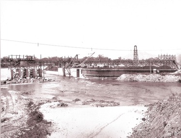
Album - Hume Reservoir Australia Album - Work proceeding inside the coffer dam, August 1927
This set of photos is from a leather bound album bearing the inscription "HUME RESERVOIR AUSTRALIA" plus 'The Rt. Hon. L. C. M. S. Amery, P. C., M .P.' all inscribed in gold. It was presented to The Rt. Hon. L. C. M. S. Amery, P. C., M. P, Secretary of State for Dominion Affairs on the occasion of his visit to the Hume Reservoir on 2nd November 1927. This album is of local and national significance as it documents the planning and development of the Hume Reservoir up to 1927. It was the largest water reservoir in the British Empire. The album records the pioneering engineering work that went into its construction.DEPARTMENT OF PUBLIC WORKS, N.S.W. RIVER MURRAY WATERS SCHEME. HUME RESERVOIR. 25. Work proceeding inside the Coffer Dam. This shows the curving downstream face of the Spillway section taking shape, the bottom edge being the line of the contraction joint between the wall and the energy dissipater which has still to be built. Note the steam navvy at the end of the bit of curved work ready to take out the foundations for the energy dissipater. The tall concrete pillar is a portion of the work at the intersection of the main and south wing walls which was built in advance of the rest of the work to accommodate the tail tower of the cableway. The Tail Tower for the first stages of the work stood on the ground. Part of it is seen erected on the pillar while part of it is still in its original position. To command the concreting of the pillar end of the south wing wall a twin hoist tower of steel construction was erected at the end of the belt conveyor. This hoist is 160 feet high. The belt conveyor will at a later stage be raised for the concreting of the upper portion of the dam and the trestles are now being built up for that purpose. A drag line excavator with a 2 cubic yard capacity bucket is at work near the tail tower on the foundations for the south wing wall. New South Wales, August 1927.hume reservoir australia, river murray waters scheme, hume reservoir construction -
 Wodonga & District Historical Society Inc
Album - Hume Reservoir Australia Album - Work proceeding inside the coffer dam (2), August 1927
This set of photos is from a leather bound album bearing the inscription "HUME RESERVOIR AUSTRALIA" plus 'The Rt. Hon. L. C. M. S. Amery, P. C., M .P.' all inscribed in gold. It was presented to The Rt. Hon. L. C. M. S. Amery, P. C., M. P, Secretary of State for Dominion Affairs on the occasion of his visit to the Hume Reservoir on 2nd November 1927. This album is of local and national significance as it documents the planning and development of the Hume Reservoir up to 1927. It was the largest water reservoir in the British Empire. The album records the pioneering engineering work that went into its construction.DEPARTMENT OF PUBLIC WORKS, N.S.W. RIVER MURRAY WATERS SCHEME. HUME RESERVOIR. 26. Work proceeding inside the coffer dam. This view was taken from the edge of the cut for the South Wing Wall foundations looking from the opposite direction to that of the preceding photograph, the curving downstream face of the main wall being seen beyond the steam navvy. This view shows the way in which the concrete paddocks are stepped and broken jointed vertically and horizontally. In the distance is the North Wing Wall and Power House stack beyond it. New South Wales, August 1927.hume reservoir australia, river murray waters scheme, hume reservoir construction -
 Wodonga & District Historical Society Inc
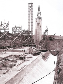
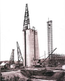
Album - Hume Reservoir Australia Album - Concrete pillar for tall tower, New South Wales, August 1927
This set of photos is from a leather bound album bearing the inscription "HUME RESERVOIR AUSTRALIA" plus 'The Rt. Hon. L. C. M. S. Amery, P. C., M .P.' all inscribed in gold. It was presented to The Rt. Hon. L. C. M. S. Amery, P. C., M. P, Secretary of State for Dominion Affairs on the occasion of his visit to the Hume Reservoir on 2nd November 1927. This album is of local and national significance as it documents the planning and development of the Hume Reservoir up to 1927. It was the largest water reservoir in the British Empire. The album records the pioneering engineering work that went into its construction.DEPARTMENT OF PUBLIC WORKS, N.S.W. RIVER MURRAY WATERS SCHEME. HUME RESERVOIR. 28. Concrete Pillar for Tail Tower. This shows the back and upstream side of the tower. The groove at the back is left for the reception of the concrete core wall of the earth embankment. The groove is being used at present as a hoist well, up and down which men and materials are conveyed in connection with the re-erection of the Tail Tower of the cableway. The pillar is 108 feet from the ground and is within 4 feet of its ultimate height. The foundation of this part at its deepest is 90 feet below the natural surface so that when the 80 feet tower and jury mast are in place the total height from foundation to top of mast will be about 300 feet. New South Wales, August 1927.hume reservoir australia, river murray waters scheme, hume reservoir construction -
 Wodonga & District Historical Society Inc
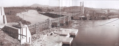
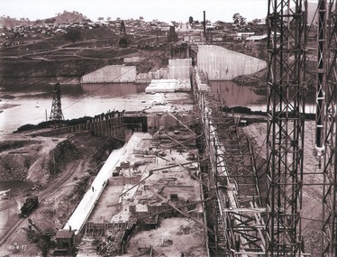
Album - Hume Reservoir Australia Album - View of concrete dam from top of tall tower pillar, August 1927
This set of photos is from a leather bound album bearing the inscription "HUME RESERVOIR AUSTRALIA" plus 'The Rt. Hon. L. C. M. S. Amery, P. C., M .P.' all inscribed in gold. It was presented to The Rt. Hon. L. C. M. S. Amery, P. C., M. P, Secretary of State for Dominion Affairs on the occasion of his visit to the Hume Reservoir on 2nd November 1927. This album is of local and national significance as it documents the planning and development of the Hume Reservoir up to 1927. It was the largest water reservoir in the British Empire. The album records the pioneering engineering work that went into its construction.DEPARTMENT OF PUBLIC WORKS, N.S.W. RIVER MURRAY WATERS SCHEME. HUME RESERVOIR. 29. View from Top of Tail Tower Pillar - Concrete Dam. This was taken from the top of the Tower described in the preceding photograph looking towards New South Wales. (WHS 00722) First is the part of the spillway being built inside the Coffer Dam, then over the Coffer Dam the submerged portion of the Spillway and outlet sections for the river diversion, beyond that the situation for the hydro-electric turbo passages bounded by the North Wing Wall. The gap may be seen in wing wall for the passage of the belt conveyor and half of the concrete mixer house behind. This gives a general view of the New South Wales Township. The Quarry is on the side of the hill showing up beyond the Township. New South Wales, August 1927.hume reservoir australia, river murray waters scheme, hume reservoir construction -
 Wodonga & District Historical Society Inc
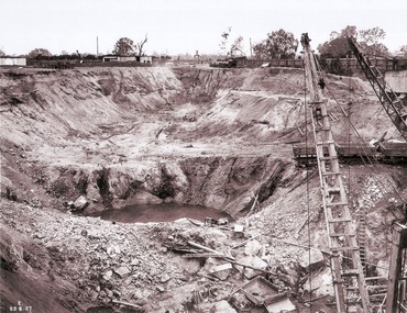
Album - Hume Reservoir Australia Album - View of South Wing Wall Foundations from Top of Tail Tower Pillar, August 1927
This set of photos is from a leather bound album bearing the inscription "HUME RESERVOIR AUSTRALIA" plus 'The Rt. Hon. L. C. M. S. Amery, P. C., M .P.' all inscribed in gold. It was presented to The Rt. Hon. L. C. M. S. Amery, P. C., M. P, Secretary of State for Dominion Affairs on the occasion of his visit to the Hume Reservoir on 2nd November 1927. This album is of local and national significance as it documents the planning and development of the Hume Reservoir up to 1927. It was the largest water reservoir in the British Empire. The album records the pioneering engineering work that went into its construction.DEPARTMENT OF PUBLIC WORKS, N.S.W. RIVER MURRAY WATERS SCHEME. HUME RESERVOIR. 30. View from Top of Tail Tower Pillar - South Wing Wall Foundations. This photograph was taken at right angles to the preceding one, (WHS 00723) ooking downstream along the cut for the South Wing Wall foundation. The granite is at a greater depth here than elsewhere and the cut will be twice as deep before the foundations are cleared. New South Wales. August 1927.hume reservoir australia, river murray waters scheme, hume reservoir construction -
 Wodonga & District Historical Society Inc
Album - Hume Reservoir Australia Album - Earth embankment on Victorian side from Top of Tail Tower Pillar, August 1927
This set of photos is from a leather bound album bearing the inscription "HUME RESERVOIR AUSTRALIA" plus 'The Rt. Hon. L. C. M. S. Amery, P. C., M .P.' all inscribed in gold. It was presented to The Rt. Hon. L. C. M. S. Amery, P. C., M. P, Secretary of State for Dominion Affairs on the occasion of his visit to the Hume Reservoir on 2nd November 1927. This album is of local and national significance as it documents the planning and development of the Hume Reservoir up to 1927. It was the largest water reservoir in the British Empire. The album records the pioneering engineering work that went into its construction.DEPARTMENT OF PUBLIC WORKS, N.S.W. RIVER MURRAY WATERS SCHEME. HUME RESERVOIR. 31. View from Top of Tail Tower Pillar - Earth Embankment, Victoria. This is a general view of the embankment which is being constructed by the Victorian Constructing Authority. The bank at its base is about 650 feet wide and it is about half its ultimate height. In the middle is the reinforced concrete core wall. At about the natural surface a tunnel for drainage and inspection purposes is built along the downstream side of the core wall but this cannot be seen. The Victorian workshops and township are located on the high ground beyond the embankment. The embankment curves round to the left at the side of the valley and will eventually block the gulley where the bushy tree stands. Access to one of the cuttings from which material is being got for the embankment is gained by means of this gulley at present. Part of another cutting may be seen on the right hand side at the back. August 1927.hume reservoir australia, river murray waters scheme, hume reservoir construction -
 Wodonga & District Historical Society Inc
Album - Hume Reservoir Australia Album - Earth embankment, Victoria, August 1927
This set of photos is from a leather bound album bearing the inscription "HUME RESERVOIR AUSTRALIA" plus 'The Rt. Hon. L. C. M. S. Amery, P. C., M .P.' all inscribed in gold. It was presented to The Rt. Hon. L. C. M. S. Amery, P. C., M. P, Secretary of State for Dominion Affairs on the occasion of his visit to the Hume Reservoir on 2nd November 1927. This album is of local and national significance as it documents the planning and development of the Hume Reservoir up to 1927. It was the largest water reservoir in the British Empire. The album records the pioneering engineering work that went into its construction.DEPARTMENT OF PUBLIC WORKS, N.S.W. RIVER MURRAY WATERS SCHEME. HUME RESERVOIR. 32. Earth Embankment, Victoria. Looking down on the earth embankment and core wall. The earth is conveyed to the bank by rail, tipped out and then put in place by wheeled scoops, the horses and wheels treading and rolling the material into a very compact form while hoses play water on the mass to keep it moist. The concrete pillar with Tail Tower, and North Wing Wall, look very small in the distance. August 1927.hume reservoir australia, river murray waters scheme, hume reservoir construction -
 Bacchus Marsh & District Historical Society
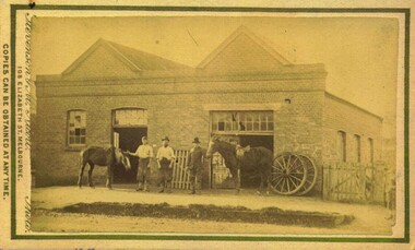
Photograph, Woolpack Stables Bacchus Marsh 1883
This image is one of a series of photographs taken by Melbourne based photographers Stevenson and McNicoll who visited Bacchus Marsh and its nearby districts between September and November 1883. James Elijah Crook settled in Bacchus Marsh in 1841 and soon after held a licence for a lodging house on the Portland Road. In about 1845, he built the first Woolpack Inn, a slab building of eight rooms. This was replaced in 1850 with a “stately country villa” of brick and stone. The stables were also built in 1850 to accommodate twenty horses. In 1851, Crook established a coach service to the goldfields. After being in use as a Court of Petty Sessions, the Woolpack Inn lost its licence and closed in 1862. After this date, Crook took an interest in horse-breeding and continued to use the stables for his horses. His most notable success was with his horse, Saladin, which won the Australia Cup in 1872, after two exciting dead-heats with The Flying Dutchman. James Elijah Crook died in 1889. The Woolpack Inn and Stables were sold and then used as a hay and corn store. In 1910 the site was leased for use as an abattoir. The Woolpack Inn was demolished in 1931. The site is still in use as an abattoir. Little remains of the original stables.Small sepia 'carte de viste' style unframed photograph on card with gold border framing photograph. Housed in the Jeremeas Family Album which contains photographs of Bacchus Marsh and District in 1883 by the photographers Stevenson and McNicoll. The photo is of a gable-roofed commercial stables with shingled roofing, and white-washed render to the walls, standing in a large cleared yard. There is a skillion extension to the south-west corner. On the front (northern) wall can be seen a door and three windows, two large and one small paned window in the centre. The eastern window is paned, while the western window has louvres and a pull-out blind. Three S shaped stays can be seen on the northern wall. Along the western wall are two more windows and doors. A mound of hay lies at the north-western corner. Standing at the front of the stables is a group of five men and two boys, one holding a large dog. Four of the men are dressed in workman’s clothing and some are holding tools of their trade. The man at the back is wearing more formal clothes and has distanced himself from the workmen. The pole against which one of the workmen is leaning appears to have damage along one side. This pole may have been used as a hitching post as there is a footrest installed lower down to make mounting easier. Printed On the front: Stevenson & McNicoll. Photo. 108 Elizabeth St. Melbourne. COPIES CAN BE OBTAINED AT ANY TIME. On the back: LIGHT & TRUTH inscribed on a banner surmounted by a representation of the rising sun. Copies of this Portrait can be had at any time by sending the Name and Post Office Money Order or Stamps for the amount of order to STEVENSON & McNICOLL LATE BENSON & STEVENSON, Photographers. 108 Elizabeth Street, MELBOURNE. stevenson and mcnicoll 1883 photographs of bacchus marsh and district -
 Bacchus Marsh & District Historical Society
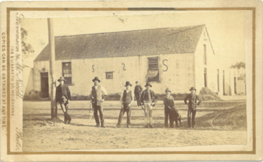
Photograph, Marshall's Blacksmith Shop 1883
This image is one of a series of photographs taken by Melbourne based photographers Stevenson and McNicoll who visited Bacchus Marsh and its nearby districts between September and November 1883. William Marshall opened his new premises in Main Street in June 1869. In the following November he opened a wheelwright shop adjacent to his smithy. Mr T. Carlton was the wheelwright. The Marshall Blacksmith building was located next to the ANA Hall in Main Street. It was demolished in 1910 to make way for a new building known as the Chambers Building. In the nineteenth and early twentieth centuries, the blacksmith played an essential role in the functioning of the whole community. Before the industrialisation of manufacturing, all metal objects, including farm implements, building requirements and domestic utensils were made by hand. As mechanisation of industry increased, the smith commonly performed the role of farrier in the times when horse power was pivotal to all aspects of society. Complementing this work, the forge was often allied with a wheelwright's shop. These premises also acted as a meeting place for the men of the town, where news was shared and friendships forged. Small sepia 'carte de viste' style unframed photograph on card with gold border framing photograph. Housed in the album, 'Photographs of Bacchus Marsh and District in 1883 by Stevenson and McNicoll'. William Marshall opened his new premises in June 1869, and in the following November opened a wheelwright shop adjacent to his smithy. Mr T. Carlton was the wheelwright. The photograph shows a brick building with two gables and two large doors, indicating that a second workshop has been added to the original building. Parts of a picket fence and two cartwheels lean against the wall. Three men stand at the front, two wearing the distinctive farrier’s apron slit between the knees. The third man is wearing more formal clothing. Two of the men hold the reins of two horses. A picket fence runs along the front of a spare block at the side of the building. The deep gutter is straddled by two crossing points. Printed On the front: Stevenson & McNicoll. Photo. 108 Elizabeth St. Melbourne. COPIES CAN BE OBTAINED AT ANY TIME. On the back: LIGHT & TRUTH inscribed on a banner surmounted by a representation of the rising sun. Copies of this Portrait can be had at any time by sending the Name and Post Office Money Order or Stamps for the amount of order to STEVENSON & McNICOLL LATE BENSON & STEVENSON, Photographers. 108 Elizabeth Street, MELBOURNE. blacksmiths, shops bacchus marsh vic., william marshall 1839-1914 -
 Linton and District Historical Society Inc
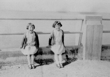
Photograph, Reilly Twins at the Seaside, circa 1925, 1925
Part of photograph album donated by Mrs Faull. Mr Reilly was Grenville Shire Engineer 1923-1930 Girls approximately 8 years old on a day at the seaside.Sepia photograph of two young girls wearing short summer dresses and cardigans sitting beside each other on low wall at seaside.reilly twins, faull collection -
 Bendigo Historical Society Inc.
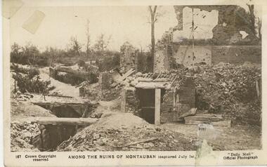
Postcard - BLANCHE SLY POSTCARD COLLECTION, 1900 - 1920
... Pyramid, Victoria, Australia Sender - Martin Walls Dated 11.6.17 ...Postcard Album of Blanche Sly. Postcards stored in Folder 81 (49 postcards). 1403.1 - 1403.28 Grey linen look cover with picture of a small sailing boat pasted centre front pf cover. Partly torn sticker on lower LH corner. Blanche Victoria SLY Born: 11 Oct 1890, daughter of William and Hannah Sly Address: 1913; Loddon Vale Address: 1980; 100 Barnard Street Bendigo Died: Bendigo 12 June 1982, buried Bendigo G3 William Sly: Born: 1856 at Smythesdale, Victoria Married in Victoria in 1887; Hannah Theilman Died: Bendigo 1937, buried Bendigo G1 Hannah Sly Nee Theilman Born: 1866 Married in Victoria in 1887; William Sly Died: Bendigo 1948, buried Bendigo G3 See additional Research .Postcard Album of Blanche Sly containing 49 postcards. See 1403 Sepia photo of some bombed ruins at Montauban (captured July 1st, 1916) Official photograph of the 'Daily Mail' Addressee - Miss B. Sly, Loddon Vale P.O., Via Pyramid, Victoria, Australia Sender - Martin Walls Dated 11.6.17postcard, collector, blanche sly -
 Lakes Entrance Historical Society
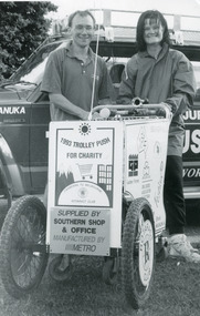
Photograph - Fundraising, Lakes Post Newspaper, 1993
number in album 03346.02Black and white photograph Peter Wilkinson and Jenny Wall volunteer members of the Rotaract Club pushing trolley fundraising for brain injury charity, as they passed through from Canberra to Melbourne. Lakes Entrance Victoria volunteering, fundraising