Showing 1219 items
matching 47
-
 Eltham District Historical Society Inc
Film - Video (VHS), Diamond Creek Fire Brigade, c.1955-1987
Combination of three movie films. Movie One (1950s): 00:00 – 13:14 Black and white footage of Diamond Creek firemen practising in Diamond Street in the 1950s for forthcoming demonstrations of abilities. Mentions of Gordon Brandy and Joe Hislop Running out hoses from old hose reels along Diamond Street, Diamond Creek Displays from various brigades running out and connecting hoses. Also scenes from the 1950s of Diamond Creek Fire Brigade competing in various locations around Victoria and Tasmania. Mentions of Brigade members Dave Kidd, Bruce Hackett, Ron Kirkbride, Jack Marks, Graham Upton who are prominent in these events. Members of Kyneton Fire Brigade also present. Members competing in running out hose reels, connecting hoses togethers and to hydrants then climbing towers to direct water from hose or at a target hanging above the road. Diamond Creek members identified wearing a diamond on their chest and back. Includes scenes of Scottish pipe bands at the events and significant crowds of spectators. Footage of Mel Stone and Beryl Marks, Stan Redpath and Ron Kirkbride, then Ron Kirkbride and Eric Holt viewing flower displays. Film changes to colour at Diamond Creek oval for practice with fire engine entering oval. Members depicted include Bill May, Jack Sinclair, Jim Cox, Bob Beale, Dave Kidd, Bruce Hackett and Captain Clarrie Stone. Reverts to black and white in the 1950s where the Brigade joins forces with the Diamond Valley Community Hospital for a Gala Day on the Diamond Creek Oval. Changes to colour again, possibly same event and scenes of children on bikes and scooters or with prams and carts racing around the oval. Mention of young lad Brian Laurie who has his own fire truck. Dart throwing, pony rides. Scenes with Dr Don Cordner, Gus Lyons, Vic Cohn (?) and spinning wheel and Diamond Creek School children entertain a large crowd with Maypole dancing. Movie Two (1950s): 13:25 – 19:00 This black and white film was taken by a TV film crew in the 1950s depicts a typical call out for the Diamond Creek Fire Brigade. In this case the careless action of a member of the public throwing a lighted match from a car, which can cause extensive damage. Footage features the Shire of Eltham War Memorial tower at Kangaroo Ground before it was modified with a fire spotter’s cabin. Discusses fire spotting operations from the tower. Shows a fire spotter walking around the top of the tower. A fire is detected, and the information is relayed to the nearest fire station, in this case, Diamond Creek. The telephone call is received, and the alarm sounded. Captain Clarrie Stone and firemen May and Shaw leave their workplaces and prepare for action. Scenes of running across the Main Hurstbridge road showing the shops (Shell service station and Chemist prominent). Scenes entering the fire station which has a pictorial warning covering the entire door “Only you can prevent forest fires – If you’re careless – we’re homeless!” Eric Holt pinpoints the location of the fire while Captain Clarrie Stone and Fireman Shaw take note. The advance vehicle (an FE Holden ute, rego GTE-696) leaves to assess the extent of the fire. Having assessed the fire, Fireman Shaw communicates with base showing radio with call sign VL3JZ. Eric Holt takes the call. In the meantime, Captain Clarrie Stone and Fireman Shaw undertake some limited action to address the fire. Firemen Bill May, Jim Bates and Hugh Bar (?) man the tanker. A photo portrait of Queen Elizabeth is visible hanging on the wall. They are later joined by Firemen Jim Cox, Eric DeBuse (?) and Jack Marks. The tanker is seen departing the station and diverging off before the bridge. Captain Clarrie Stone and Fireman Shaw are seen pumping water on the flames with hand pumps when the tanker arrives. The hose is unreeled, and water turned on the flames. Jack Sinclair joins the action. Jim Cox directs water to the high stuff. The fire put out, Jack Marks and Eric DeBuse wind in the hoses and the team head back to town. It’s peaceful again at the memorial tower. Movie Three (1969-1987): 19:14 – 34:34 Colour film “Fired with Dedication”, Country Fire Authority Victoria, produced by I.L. Wadeson, Commentary by A.M. Hem. Credits with CFA Victoria emblem and then placed over a view of an old-style ladder engine. Opens with the scene of a fire engine outside the Diamond Creek Fire Station then various trophies reflecting the competition success of the brigade in various track and disciplined events. Two trophies shown of particular pride to the brigade were for first place in the Torchlight Procession at the State Championships in Mildura in 1986 and also at Swan Hill in 1981. Still photo scenes of ex Captain Clarrie Stone, Brigade Captain for 21 years; ex Captain Jack Marks, 10 years; ex Captain Ian Douglas, 10 years. Cuts to scene of radio control room, January 1969, and news of a fire on the northern side of the township of Diamond Creek. With scenes of flames in bush, the narration explains that until the early 1960s the area was an orchard district which protected the town against the savagery of bushfires. But due to competition from other areas more suitable for orcharding and easier transport to Melbourne the district could no longer remain competitive, and orchards were replaced by grassed areas, which together with the bush areas were a feeding ground for fire. On 8th January 1969, high temperatures and strong north winds, were, with the carelessness of some individual all that was necessary to produce the worst fire the district had seen. Cuts to scene of blackened fields and cattle - Hundreds of hectares of grass land were blackened, and cattle had to be transported to other areas for agistment. Scene of destroyed buildings in the township – 13 houses and the public hall in the town were destroyed as was the theatre equipment which was owned by the fire brigade. The Church of England Hall and bell tower were badly damaged. The whole town could have been burnt out but for the determination, skill, and courage of the Diamond Creek Fire Brigade. Scenes of all that was left of the home on the hill on the west side of the Church of England. Also, the remains of the old Pisy (?) home on the top of the same hill near Lambert Street, and the ruined Crocker home. Cuts to a scene in the mid-1970s to mid-1980s of a house fire in Haley Street attended by the Diamond Creek Fire Brigade. Although the house was severely damaged, it was saved. Mentions that whilst assistance is appreciated, in some circumstances, those doing so are not properly dressed for fighting fires. Breathing apparatus is a must in structure fire attack. Next scene (either on Mangarook or Coventry oval) showing off four Diamond Creek Fire Brigade efficient and very expensive firefighting units. Features a forward control vehicle Toyota 4WD used for conveying task force personnel to the required areas; a Hino Model 3.2 tanker, diesel powered and carries 3,000 litres of water and has a 16 HP petrol driven pump which delivers 900 litres of water per minute; an International tanker (registration TCM-418) which carries 3,000 litres of water with pumping capacity of 600 litres per minute. The Ford diesel powered pumper (registration MXE-754) is a well-equipped vehicle with a water capacity of 1,000 litres and capable of pumping 1,900 litres of water per minute from the main pump, has many lockers which hose equipment such as breathing apparatus and various types of hose nozzles and foam making equipment. The vehicle carries 360m of 64mm diameter hose which can be laid out from the rear lockers and a portable lighting plant, an Oxy Viva resuscitator to revive smoke inhalation victims and forcible entry tools to gain access to structure fires. Views of the main pump and control panel on the vehicle. As well as the main pump, the vehicle is equipped with an auxiliary pump which allows the facility to pump whilst moving. Fire fighters must undergo constant training and hone their skills, Scenes of a training exercise using the pumper to pump from static water. First, the short lengths of suction hose are coupled, a strainer fitted to ensure debris does not foul the pump. Gauges must be constantly monitored to ensure manageable water pressures are maintained. Pressures are normally controlled to allow two fire fighters to work at each nozzle outlet. Two nozzles are tested, one adjustable jet fog type which is used on flammable gasses or within a structure fire to absorb heat. A straight jet nozzle to project water long distances to protect exposed surfaces close to a fire radiated heat. The pumper is quite a versatile vehicle in handling structure fires, but it also carries specialist equipment needed in containing hazardous chemical incidents. Cuts to scene of parade – the Diamond Creek Fire Brigade has with other neighbouring brigades participated in most town fairs and earns the respect of the watching public. It can be seen why this brigade has been so successful at disciplined contests. Views of Plenty Fire Brigade Road Rescue unit which is equipped with the “Jaws of Life” Scenes of athletic competitions – many neighbouring brigades indulge in friendly but keen competition at the Diamond Creek Town Fair. The young are also encouraged to participate in all aspects of Junior Fire Brigade activities and become tomorrow’s generation of volunteer fire fighters. Scene of the 1986 Diamond Creek Town Fair which was the last time veteran Captain Clarrie Stone BEM marched with the brigade. Clarrie was awarded the British Empire Medal for his service to the Country Fire Authority. Also, scenes of vehicles in the parade. Cuts to scene of brigade members in drill formation for inspection by Acting Chief Harry Rothsay (?) on the occasion of the opening of the new fire station extensions on August 29, 1987. Rudy Libel (?) Captain at the time. Scenes of crowds including many dignitaries of neighbouring brigades present including Lieutenant Gordon Grandy (who came down from Queensland for the occasion) and ex-Secretary David Kidd and wife Betty, also ex Captain Clarrie Stone and Mrs Nel Stone, a life member of the Ladies Auxiliary, the Reverend Jock Ryan, son of J.L Ryan, founder of the Diamond Creek Fire Brigade, Foundation Captain of the fire brigade, Keith Bradbury and Mrs Bradbury. Pauline Dick accepts a community service award for services to the CFA. Recognising over 47 and a half years of service, a presentation is made by Mr Neil Marshall, Acting Chairman of the CFA to ex Captain Clarrie Stone with response by Clarrie. Other members of the official party include Cr. Martin Wright, Shire President Wayne Phillips and local Member of Parliament, Mrs Pauline Toner. Ex foreman John Bennett is presented with a life member’s awards by Captain Rudy Libel. The camera also catches Gwen Cox, Jean Ryan and Bessie Layton (?) Provides historic footage of people, places and equipment and a record of the worst fires expoerienced in Diamond Creek in 1969BASF Standard Quality SQ E-180 VHS dubbing (poor quality) of three films Converted to MP4 file format 0:34:38, 1.85GBOn label: "Donation - August 2000 Diamond Creek Unit Old films made up from Fire Brigade shows at competitions - also Kangaroo Ground Tower being used"video recording, diamond creek fire brigade, 1986 diamond creek town fair, a.m. hem, acting chief harry rothsay, athletic competitions, beryl marks, bessie layton, betty kidd, bill may, bob beale, brian laurie, bruce hackett, captain clarrie stone, chemist, church of england hall, clarrie stone, clarrie stone bem, country fire authority victoria, coventry oval, cr. martin wright, crocker home, dart throwing, dave kidd, david kidd, diamond creek, diamond creek fire station, diamond creek oval, diamond creek school, diamond creek town fair, diamond street, diamond valley community hospital, dr don cordner, eric debuse, eric holt, fe holden ute, fire damage – buildings, fire spotter, fire spotter’s cabin, fire station extension, fired with dedication (film), firefighting units, fireman shaw, firemen jim cox, ford pumper, foundation captain, gala day, gordon brandy, gordon grandy, graham upton, gus lyons, gwen cox, haley street, hino model 3.2 tanker, house fire, i.l. wadeson, ian douglas, international tanker, j.l ryan, jack marks, jack sinclair, january 1969, jaws of life, jean ryan, jim bates and hugh bar, jim cox, joe hislop, john bennett, kangaroo ground, kangaroo ground tower, keith bradbury, kyneton fire brigade, lambert street, main hurstbridge road, mangarook oval, maypole dancing, mel stone, mildura 1986, mrs bradbury, mxe754 vic registration, neil marshall, nel stone, orchard district, oxy viva resuscitator, pauline dick, pauline toner mp, pisy home, plenty fire brigade road rescue unit, pony rides, radio control room, reverend jock ryan, ron kirkbride, rudy libel, shell service station, shire of eltham war memorial, shire president wayne phillips, spinning wheel, stan redpath, state championships, swan hill 1981, tcm418 vic registration, torchlight procession, toyota 4wd, trophies, vic cohn, victorian bushfires - 1969, vl3jz -
 Unions Ballarat
Scrapbook: Ballarat Trades Hall newspaper clippings 1988-1996, The Courier
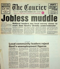
1a. Jobless muddle: Ballarat leaders say local survey closer to mark than Govt's 'drastic underestimate' 1b. Local community leaders reject Govt's unemployment figures Paper: The Courier Date: 15 November 1991 2. Ballarat must change industry base: Shearer - Reliance on wool and wheat now redundant Paper: n.a. Date: 14 November 1991 3.Lay-offs plan sparks strike [Ballarat] Paper: The Courier Date: 13 November 1991 4a. Ballarat makes pleas to Hawke: Help us beat jobless problem 4b. Help us create jobs plea to Canberra Paper: The Courier Date: 8 November 1991 5. Ballarat to plead for its life Paper: The Courier Date: 8 November 1991 6. Disunity blasted: Council bickering 'sabotaging local economy' [Ballarat] Paper: The Courier Date: 9 May 1992 7. Hand cuts migrant intake: Ballarat Trades Hall welcomes cut Paper: n.a. Date: 13 May 1992 8. School leavers 'missing out' Paper: The Courier Date: 18 May 1992 9. 10,000 in rally over government assets sale Paper: n.a. Date: 8 July 1992 10. Unions seek views on amalgamation [Ballarat] Paper: The Courier Date: 30 May 1992 11. Jobs plan hailed: Local leaders say it'll help young jobless [Ballarat] Paper: The Courier? Date: 26 June 1992 12. Youth wage gets mixed reaction [Ballarat] Paper: The Courier Date: 7 July 1992 13. Plans to axe tariffs are 'frightening': Shearer [Ballarat] Paper: The Courier? Date: 11 July 1992 14. Asbestos scare at primary school [Ballarat] Paper: The Courier Date: 11 July 1992 15. Ballarat protest: 5000 rally against the Kennett Govt Paper: n.d. Date: 11 November 1992 16. The Ballarat strike (pictures) Paper: The Courier Date: 11 November 1992 17. Train services under threat, warns union [Ballarat] Paper: n.a. Date: n.d. 18. Shearer slams new WorkCare Paper: n.a. Date: 5 November 1992 19. Ballarat unions back strike against Govt Paper: The Courier Date: 7 November 1992 20. Youth late night lolly selling may be both risky and illegal [Ballarat] Paper: The Courier Date: 5 December 1990 21a. 500 Ballarat jobs 'at risk' 21b. Tariff cuts will hit Ballarat jobs Paper: The Courier Date: 5 December 1990 22. Govt blueprint to hit local industries [Ballarat] Paper: The Courier Date: n.d. 23. AHA wage move rejected: Pay rise offer in place of penalty rates [Ballarat] Paper: The Courier Date: 9 July 1991 24. City shops leave Sunday to big stores [Ballarat] Paper: n.a. Date: 18 July 1991 25. Union dispute threat to Base [Ballarat] Paper: n.a. Date: 23 July 1991 26. Metalworkers agree on wages: Unions call on IRC to accept agreement Paper: The Courier Date: 19 July 1991 27. Ballarat bakery fears price war Paper: n.a. Date: 28 June 1991 28. Ballarat CES in Newstart bans Paper: n.a. Date: 29 June 1991 29. No Sunday trading: rally seeks support Paper: The Courier Date: 29 June 1991 30. The re-emerging Trades Hall belong to all workers [Ballarat] Paper: The News Date: 15 September 1988 31. Work safety better: TLC [Ballarat] Paper: n.a. Date: 15 September 1998 32. Black ban on bank [Ballarat] Paper: n.a. Date: 28 February 1989 33. BTLC slams Stockdale Workcare 'rort' claims Paper: n.a. Date: 11 May 1989 34. BTLC backs luxury surcharge plan [Ballarat] Paper: n.a. Date: 24 June 1989 35. Strike ends at John Valves [Ballarat] Paper: n.a. Date: 21 June 1989 36. Unions need a better image: 'Future is linked to intensive education process' [Ballarat] Paper: n.a. Date: n.d. 37. Ballarat protest against Govt: Teachers vow to fight Govt Paper: The Courier Date: 3 December 1992 38. Cleaners vote not to take industrial action [Ballarat] Paper: The Courier Date: 3 December 1992 39. Nurses stop work [Ballarat] Paper: The Courier Date: 3 December 1992 40. Amcast to close: Up to 140 will be made redundant [Ballarat] Paper: n.a. Date: 5 December 1992 41. Ronaldson hits out at union's 'fear campaign' [Ballarat] Paper: n.a. Date: 5 December 1992 42. Reprieve for Amcast workers [Ballarat] Paper: n.a. Date: n.d. 43. Workers take levy protest to Traynor [Ballarat] Paper: n.a. Date: 10 December 1992 44. Unions claim 2000 jobs lost in 12 months [Ballarat] Paper: The Courier Date: 6 October 1993 45. Unions plan on strong show [Ballarat] Paper: n.a. Date: 28 November 1992 46. Union rally to blast WorkCover [Ballarat] Paper: n.a. Date: 17 July ? 47. 1800 unionists in action day [Ballarat] Paper: n.a. Date: 1 December 1992 48. Protest at Lakeside stops work [Ballarat] Paper: n.a. Date: 1 December 1992 49. Ballarat urged to fight Amcast closure Paper: n.a. Date: 7 December 1992 50. Big crowd expected at deficit tax rally [Ballarat] Paper: n.a. Date: 12 December 1992 51. Trade unions: Recruit drive in Ballarat Paper: The Courier Date: 14 September 1995 52. Church and union unite for protest [Ballarat] Paper: n.a. Date: 14 September 1995 53. Ballarat strike tomorrow Paper: n.a. Date: 15 December 1992 54. Govt accuses striking unions of 'thuggery' Paper: n.a. Date: 15 December 1992 55. Hundreds support rally [Ballarat] Paper: n.a. Date: 14 December 1992 56. Disagreement on new Fightback package Paper: n.a. Date: 19 December 1992 57. Unions boycott public rally [Ballarat] Paper: n.a. Date: 19 December 1992 58. Group aims to fight deficit levy [Ballarat] Paper: n.a. Date: 21 December 1992 59.42 jobs go at workshops, more cut backs feared Paper: The Courier Date: 24 December 1992 60. ALP against levy: Devereaux Paper: The Courier Date: 3 February 1993 61. Rail workers fight for jobs [Ballarat] Paper: n.a. Date: 6 January 1993 62. Trams and buses to be disrupted [Ballarat] Paper: n.a. Date: 6 January 1993 63. Brown snubs rail talks [Ballarat] Paper: n.a. Date: 6 February 1993 64. Deficit levy is causing hardship: Trades Hall [Ballarat] Paper: n.a. Date: 5 February 1993 65. Ballarat unions to rally on March 1 Paper: n.a. Date: 5 February 1993 66. Angry rail workers plan to see Brown [Ballarat] Paper: n.a. Date: 8 January 1991 67. Sharing the secrets of the camera Paper: The Courier Date: 6 February 1993 68. Councils must unite: Shearer [Ballarat] Paper: The Courier Date: 9 February 1993 69. Shearer hits Lib health policies Paper: n.a. Date: 11 February 1993 70. Worker injury costs 'shifted' to taxpayers [Ballarat] Paper: n.a. Date: ? June 1993 71. Shearer warns on contracts Paper: n.a. Date: 5 February 1993 72. Ballarat hurting, says union chief Paper: n.a. Date: 22 February 1992 73. Workers will back protest, says Shearer [Ballarat] Paper: n.a. Date: 22 February 1992 74. Shearer gives Govt a blast on 'sacrifice' Paper: The Courier Date: 17 February 1993 75. Shearer supports strike [Ballarat] Paper: The Courier Date: 1 March 1993 (?) 76. Workers may be 'scared off" rally [Ballarat] Paper: n.a. Date: 1 March 1993 77. Workers at risk: Shearer Paper: n.a. Date: 25 February 1993 78a. 3000 marchers in protest against Kennett policies 78b. Marchers in street protest [Ballarat] Paper: The Courier Date: 2 March 1993 79. 'Jobs threat from Libs tariff plan' [Ballarat] Paper: The Courier Date: 2 March 1993 80. Students, staff rally in protest at govt cuts Paper: The Courier Date: 6 October 1993 81. Hurt workers live on $50 a week: union [Ballarat] Paper: n.a. Date: ? July 1994 82. Workers in protest at injury benefits [Ballarat] Paper: The Courier Date: 24 July 1994 83. Contracts need an 'even hand' [Ballarat] Paper: n.a. Date: ? July 1993 84. 2000 rally against public service cuts [Ballarat] Paper: n.a. Date: 6 May 1993 85. Telstra cuts threatening 100 Ballarat jobs: union Paper: n.a. Date: ? ? 1996 86. Workers to fare worse under Libs - Hubbard [Ballarat] Paper: n.a. Date: ? ? 1996 87. Ballarat workers to protest against industrial changes Paper: The Courier Date: n.d. 88. Meet Telstra, unions urge development body [Ballarat] Paper: n.a. Date: ? July 1996 89. Threat seen to part-time job security [Ballarat] Paper: n.a. Date: 6 July 1996 90. Trades Hall gears up for big battle [Ballarat] Paper: n.a. Date: ? July 1996 91a. Workers in city protest 91b. Workers in city protest Paper: n.a. Date: 31 August 1996 92. Unionists urged to fight hard for rights Paper: n.a. Date: 31 August 1996 93. Unpaid work trials a trap: Shearer Paper: The Courier Date: 9 November 1996 94. CES union action 'minor' Paper: The Courier Date: 9 November 1996 95. Sawmill row looks likely to escalate Paper: The Courier Date: 9 November 1996Significant collection of press articles that include comment from Unions Ballarat Secretary, Graeme Shearer, around the period when Jeff Kennett (Liberal Party Victoria) was premier of Victoria. Focus upon a variety of social and industrial issues impacting the Ballarat region.Scrapbook - news clippings.btlc, ballarat trades and labour council, industrial relations, industrial action - strikes, kennett jeff, liberal party victoria, victorian railways, australian labour party - alp, oh&s, unemployment - ballarat -
 Surrey Hills Historical Society Collection
Archive - Vertical file, Chatham Primary School
Chatham Primary School opened in August 1927 following local pressure for an additional school. Balwyn, Mont Albert and Surrey Hills schools were all experiencing overcrowding following population growth after WW1.A vertical file of information related to Chatham Primary School: 1. Correspondence regarding establishment of the school – all are copies: • Letter from Amy Brown to Secretary of Chatham School Committee (undated) relating to correspondence regarding the establishment of the school • Letter from Education Department to Mr. A.R. Brown, 17.5.1923. • Letter from Department of Public Works to Mrs. Amy R. Brown, 2.10.1923. • Letter from Education Department to Mr. A.R. Brown, 2.11.1923. • Letter from A. Brown to Education Department ?, 7.11.1923. • Letter from E.W. Greenwood, MLA, State Parliament House to Mr. A.R. Brown, 8.11.1923. • Letter from E.W. Greenwood, State Parliament House to Mr. A.R. Brown, 19.11.1923. • Letter from Department of Public Works to Mrs. Amy R. Brown, 5.12.1923. • Letter from Education Department to Mrs. A. Brown, 8.12.1923. • Letter from A. Brown to Mr. Greenwood, 26.7.1925. • Letter from E.W. Greenwood, State Parliament House to Mrs. A. Brown, 14.3.1925. • Letter from E.W. Greenwood, State Parliament House to Mrs. A. Brown, 15.7.1925. 2. Letter from E.W. Greenwood, State Parliament House to Mrs. A. Brown, 16.11.1925. 3. Letter from Department of Public Works to Mrs. A. R. Brown, 10.11.1926. 4. Letter from E.W. Greenwood, State Parliament House to Mrs. A. Brown, 2.3.1923. 5. Letter from E.W. Greenwood, State Parliament House to Mrs. A. Brown, 3.6.1927. 6. Letter from E.W. Greenwood, State Parliament House to Mrs. A. Brown, 29.6.1927. 7. 2 Mr. Harbert’s account for Shelter Shed, Chatham State School, (undated), (1 page). 8. 4 copies of newspaper cuttings: 9. ‘Masts tell Edina’s history’, Herald, 4.5.1931, 10. ‘Edina to have holiday on 80th birthday’, Argus, 4.5.1934, 11. ‘Edina’s birthday tomorrow’, Age, 4.5.1934, 12. ‘Old lady of the sea has a birthday’, Star, 4.5.1934 (1 page). 13. ‘The story of the steamship “Edina” a wonderful veteran of the seas’, The Meccano Magazine, A.R. Prince, December, 193 ? (1 page). 14. ‘Ponsford and schoolboys’, (paper and date unknown), (2 pages). 15. Program for ‘Trial by jury’, 16.11.1929 (1 page). 16. ‘What was the joke that the Governor told?’, paper unknown, 5.5.1931 (1 page). 17. ‘History in school flag’, paper and date unknown (1 page). 18. Lists of girl and boy dux 1928 – 1944 (1page). 19. Chatham School 4314 notes (undated) (3 pages). 20. Extracts from Box Hill Reporter, 1927-9, from Alan Holt collection (1 page). 21. Empire day celebrations in Surrey Hills in 1930s, notes from Matt Bowen, 1983 (1 page). 22. Extracts from Box Hill Reporter 1927-8 (1 page). 23. Vision and realisation, 1973 Education Department : Port Phillip Eastern Region: 4314 Chatham notes by H.H. Singleton (1 page). 24. ‘Bell has historic appeal’, paper unknown, c. 1985 (1 page). 25. Background information on the SS 'Edina' bell, Adrian Peniston-Bird, Principal of Chatham Primary School, 1982 (1 page). 26. ‘It’s there for another fifty years’, October, 1985. See also ‘Chatham past and present, a patchwork of people’. (1 page). 27. ‘Miss Marie George’, SHNN No. 40, June/July, 1989 (1 page). 28. ‘Chatham Primary School – a community within the community’, SHNN No. 56, Feb/March, 1992 (1 page). 29. ‘Chatham Primary School – another exciting year begins’, SHNN No. 68, Feb./March, 1994 (1 page). 30. ‘Chatham plans a big reunion’, SHNN No. 77, Aug./Sept. 1995 (1 page). 31. ‘In search of the past’, Progress Press, 15.5.1996 (1 page). 32. ‘Chatham primary’, SHNN No. 82, June/July, 1996 (1 page). 33. ‘Happy Birthday, Chatham Primary’, SHNN No. 84, Oct./Nov. 1996 (1 page). 34. Chatham School Fathers Club, SHNN No. 83, Aug./Sept. 1996 (1 page). 35. Notes by Doug Iversen, 18.7. year unknown, (1 page). 36. Advertisement for Chatham Primary School celebrating 70 years: ‘Take a walk down memory lane’, 10.9.1996, paper unknown (1 page). 37. Chatham Primary School invitation to 70th year celebration – Sat. 19.10.1996 (1 page), AND Back to Chatham (1 page). 38. Flyer: Chatham Primary School Reunion Celebrating 70 years 19.10.1996 (1 page, 2 copies). 39. Program ‘Welcome to Chatham Primary School No. 4314 70th celebration’, undated (1 page, 2 copies). 40. Chatham History trail, undated (1 page). 41. Drawing of Chatham Primary School, David Williams, 1995 (1 page). 42. ‘Seems like yesterday’ 1998, paper unknown (1 page). 43. ‘Schools and the environment’, SHNN No. 98, Feb./March, 1999 (1 page). 44. ‘School praises retiring head’, by Kate Morris, 19.6.2000, paper unknown (1 page). 45. “Chatham’s class of ‘30” by Meg Freeman, Progress Press, c. July, 2000 (1 page). 46. ‘Recalling a class act’, Progress Press, c. August, 2000 (1 page). 47. List of students enrolling in 1930 (2 pages). 48. ‘Boy in man’s shoes’, Progress Press, 21.8.2000 (1 page). 49. Chatham Foundation Day Lunch invitation 31.7.2000, (with contact details of former students on the back, written by Ken Hall) (1 page). 50. ‘An invitation – Chatham Primary plans for its 75th birthday’, SHNN No. 118, June/July, 2002 (1 page). 51. 75th birthday assembly – August 1st 2002 (1 page). 52. ‘Chatham lands special garden’ (paper and date unknown, possibly Progress Leader) (1 page). 53. ‘Chatham Primary celebrates specialist programs’, SHNN No. 184, June/July 2013 (1 page). 54. ‘City’s sustainable schools awarded this month’, Boroondara Bulletin, April, 2013 (1 page). 55. ‘Chatham Primary walks to win’, SHNN No. 189 March/April 2014 (1 page). 56. ‘School builds pathway to greater sustainability’, Progress Leader, 15.9.2015 (1 page). 57. ‘Schools embrace need for class action’, Age, 7.11.2016 (1 page). 58. Advertisements for 2017 grand fair 4th March, 2 designs (3 pages including 2 copies of one). 50. A history of Chatham Primary School, golden jubilee edition 1977 (9 pages with covers). 51. Photo of Mrs. Frances Le Couteur receiving a gift at Chatham Primary School, golden jubilee 1977 (1 page). 52. ‘Thank you’ letter to editor from Mrs. Frances Le Couteur (paper unknown), 1977 (1 page). 53. Letter from Chatham School No. 4314 to Mrs. Ethel Cerini, 10.2.193 ? (1 page). 54. Programme for concert held in the 1930s (source possibly Jocelyn Hall) (1 page). (mrs) amy brown, e w greenwood, albert harbert, s s edina, matt bowen, adrian peniston-bird, marie george, reunions, doug iverson, david williams, meg freeman, frances le couteur, ethel cerini -
 Creswick Museum
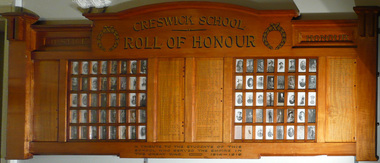
Honour Board, 1920 approx
Pupils who listed World War 1. Wooden Board with 80 small glass panels holding photographs. Four wooden panels listing 157 names of the pupils in gold lettering with red cross against the names of the soldiers who were killed. Top Creswick School Roll of Honour Botton: A tribute to the Students of this school who served the Empire. The Great War 1914-1919. Photos in LHS 1. JS Anderson 2 A Anderson 3 R Anderson 4 A Beckerleg, 5 R Bell 6 A Bernado 7 J Bernado 8 EG Booth 9 M Boradale 10 R Boradale 11 R Boradale 12 WJ Bowley 13 FA Canning 14 HGN Cassell 15 E Clarkson 16 A Clausen 17 V Crougey 18 HG Dean 19 W K Dean 20 CV Gardner 21 WG Gardner 22 RJ Gardner 23 EH Goats 24 R Gray 25 B Gray 26 AB Grose 27 CT Grose 28 BA Grose 29 JB Grose 30 W Hadler 31 W Hartley 32 GT Hewitson 33 CC Hewitson 34 W Howie 35 R Howie 36 C Howie 37 WH James 38 P Kennedy 39 WJ Lambert 40 A Lambert 41 F Lambert RHS 42 H Lambert 43 WH McFarlane 44 VH Malone 45 PJA Malone 46 J Maughan 47 J Mendham 48 AE Merriman* 49 AC New 50 T New 51 W Parkes* 52 R Pasco 53 FH Pavarno 54 EP Pavarno 55 AB Peters* 56 G Petrie* 57 T Porter 58 G Porter 59 F Porter 60 H Praetz 61 R Praetz 62 S Reeves 63 W Sherriff 64 P Short 65 J Skewes 66 N Slade 67 JC Smith 68 J Still 69 GW Tait 70 DG Toohey 71 A Tonkins 72 SH Townshend 73 E Townshend* 74 HE Townshend 75 H H Townshend 76 S Treloar 77 RJ Ward 78 WE Westcott* 79 FC Whitfield* 80 AC Wisby* Writen Names T Anderson, T Arnold, S,D,G & W Barclay, G Beaucort, B Bentwich, J Berry, E&C Blake, S&A Bush, AF, WJW & R, Bowley, J,F & HB Brady, Alex Bowley, L Brotherton, JC Caddy*, J Canning, SF Carlyon, R Chaulkey, F Clausen, F*,G & J Clifton,V Creati,B Crosbie, H* & V Clover, A Chandler, J&G Davidson, S Dean, W Denny, W Digby, C Douglas D,H* & J Drummond, G Donald*, JP Dooley, W*&A Edmends, Percy Ellis, P,SW & T Ellis, A Egglestone, W & R Fricker, A,C & Clive Falla, G Fricker, A* & W Gibson, H Gardner, EJA Gray, WEC, N & H Grose, H Green, M Glass, FP Grady, W Hadler, W Hartley, N&T Hammon, H & J Harris, W & L Hartland, R Hawkey, PA Hertford, T Hogo, R Forrestor, A,F & N James, J Jebb, Alex,A & FT Johnson, WE Jordan, P Jory, E Jane, HC,RJ & JW Kelly, A King, S knight* M Lang(Sister), Clint'n Lavas, Mat Lang, C&TJ Liddicoat, RG* & ED Lindsay, W Little, L Lucas(navy), W & C Mann, WHS Merriman, J Mitchell, S Northcott, S New, W Nicholas, V Northcott, L Orange, JT & HC Packham, E Pearce, E Pilling, J Praetz, R Williams, AM & F* Robertson, A Romeo, J Rowe, H Russell, H & C Woods, C Sandford, G Sherriff, W & F Smith, J & R Snell, A & J* Spence, W Stephenson, J A Still, W,WL & AJ Surredge, J Shaw, Jas Wisby, A Treeby, F Tregonning, FL & W Treloar, A Tremearne, R Tilt, H Vague, A Wade, H Wall, BT,IW & J Ward, J,M & O Whatman, D Wilson, H & A Wood, DG Wormald, A Wright, L Watt, A Whitfield*. -
 Unions Ballarat
Leaflets, pamphlets, periodicals, newspapers, cuttings and roneoed material retained by the Council, 1891-1962
TBATBATwo boxes, paper. 1. Anti-Hanging Committee - regarding hanging. 1962. 2. Ballarat Banking Co. Ltd. Chairman's address and 145th report. August 1954. 3. Country Municipal Association circular regarding conference on centralisation, Ballarat. 22 November 1916. 4. Geelong Town Band's weekly performance programme. n.d. 5. Ironmasters' Association of Victoria rules and regulations agreed upon at the General Iron Trades' Conference, Melbourne. 1891. 6. Melbourne Eight Hours Anniversary programme. 1901. 7. Museum of Applied Science of Victoria, on gas from our brown coal. n.d. 8. New Australian Trade Unionist Committee regarding rally to protect shooting of Polish workers. 195-? 9. Circular from Ballarat Trades and Labour Council to Ironmoulders' Society regarding the Congress. 1891. 10. List of subjects to be discussed at Congress. 11. Circular from Melbourne Trades Hall Council regarding financial help for Congress. 1891. 12. Reports of Standing Orders Committee appointed by the Congress, 23-29 April 1891. 13. Trade Mark Committee report. 14. Committee on Federation report. 15. Draft scheme of Federation (Australasian Federation of Labor). 16. Draft scheme of Federation (Australasian Federation of Labor) to the Labour Councils and Unions of Australasia. (2 copies.) 17. Asian and Pacific Regions Peace Conference, Peking, October 1962. Report on Peking, Melbourne. 1962. (2 copies). 18. Australian Bureau of Census and Statistics. Labour and Industrial Statistics, Melbourne. 1911. 19. Australia. Laws, Statutes, etc Trade Marks Bill, 1905. Workers' Trade Marks. Melbourne, 1905. 20. Australian Council of Trade Unions. Agenda paper for ... Congress, 1953. Melbourne, 1953. 21. Australian Labor Party. Work of the Labor government. Melbourne, 1928. 22. Australian Textile Union, Victorian Branch. Wages Sheet. Melbourne, 1953? 23. Baker, W.A. The Commonwealth Basic Wage. 1907-1953. Sydney, 1953? 24. Building Workers' Industrial Union. Building Workers support your convention. n.p. 1954? 25. Carters' and Drivers' Union. Committee of Management. Important to members of Carters and Drivers' Union. Melbourne, 1936. 26. Dougherty, Tom. Santamaria unmasked. Melbourne, 1954? 27. Eight Hours' Anniversary Sports Programme, 1893. Ballarat 1893. 28. Eight Hours' Anniversary Programme, 1894. Ballarat, 1894. 29. Fadden, Arthur W. The menace of political banking. Sydney, 1945. 30. Federated Clerks' Union, Victoria Branch. The Fennessy Story. The Braun Story. n.p., 1954. 31. Federated Clerks' Union, Victoria Branch. Manifesto, n.p., 1955. 32. Greater Ballarat Association. Seventeenth annual report. Ballarat, 1954. 33. Langridge, H.E. Employers in the Labor Party. Melbourne, 1914. 34. Metal Trades Federation. National Conference of Federal Council and delegates from State branches. Sydney, 1960. 35. Municipal Association of Victoria. Arbitration aware regarding employment of members of the Municipal Officers Association of Australia. Melbourne, 1950. 36. Municipality of the Town of Ballarat East. Annual report, 1919. Ballarat, 1919. 37. Plumbers and Gasfitters Employees' Association of Australia. Melbourne Branch. Why did Menzies abdicate when he had a working majority and 18 months to go? Melbourne, 1955? 38. Plumbers and Gasfitters Employees Union of Australia, Melbourne Branch. Who are the wreckers in the Australian Labor Party? Melbourne, 1955. 39. Spence, W.G. The ethics of New Unionism. Sydney, 1892. (42 copies) 40. Trades Hall Council, Melbourne. Statement of accounts, 1959. Melbourne, 1959. 41. Universal Business Directories (Australia) Pty. Ltd. Home edition for Ballarat. Melbourne, 1954. 42. Victoria, Apprenticeship Commission. Twenty-seventh annual report. Melbourne, 1956. 43. Victorian Labor College. Labor Colleges. Melbourne 191? (3 copies) 44. W.F. Williams. An appeal to the workers of Victoria. n.p., 19?? 45. Workers' Industrial Union of Australia. Preamble, classification and rules. Melbourne 1919? 46. ACTU Bulletin, 1955, Vol 2, No. 2 47. Amalgamated Engineering Union monthly journal, 1954, No. 3. March 48. American Economist, (New York), 1893, Vol 12, No 12, September 49. Australian Worker, (Sydney), 1955, Vol 64, No. 10, May; No. 15, September (held by ANU and at Trove online) 50. Building Workers' Organiser, official organ of the Building Trades Federation, 1954, June 51. Bulletin issued by the Economic Information Service, Melbourne. No. 2 1954, Nos. 10, September; 13 August; 1956, No 14, January 52. Ballarat Courier, 1890, Vol 46, No. 7096, April 53. Ballarat Star, 1888, Vol 33, No. 95, April 54. The Clerk, official journal of Federated Clerks' Union, Victorian Branch, 1955, Vol 10, No. 2, February/March 55. Common Cause, official journal of the Miners' Federation of Australia 1954 Vol 19, No. 10, March; No. 12, April 1955 Vol 20, No. 12, April; No. 19, May 1955 Vol 20, No. 23, June; No 28 July 1955 Vol 20, No. 29, August 1956 Vol 21, No. 17, May 56. Evening Echo, Ballarat, 1915, No. 6673, September 57. Evening Post, Ballarat, 1889, Vol 38, No. 6326, March 58. Industrial Herald, published by Labor Press, Geelong 1952 Vol 34, No. 35, June 1954 Vol 36, No. 20, March; No. 23, April 1954 No. 36, July; No. 39 July 1958 Vol 40, No. 19, March 59. Labor Call, published by Industrial Printing and Publicity Co., Melbourne. 1953, Vol 46, No. 2417, September 60. Labor Supplement. 1952, November 1954, February; March 61. Light, Ballarat diocesan journal. 1955, September. 62. Locomotive journal, published by the Australian Federated Union of Locomotive Enginemen. 1954, Vol. 16, No. 4, January. 63. People's Tribune Supplement, ed. by E.E. Jones, Melbourne. 1886, Vol 5, No. 20, April. 64. Railways' Union Gazette, published by J.D. Michie, Melbourne. 1919, June, Frank Byett in memoriam edition. 65. Rehab News issued by Central Ex-Servicemen's Office, Melbourne. 1946, Vol 2, No. 30, May. 66. Sheet Metal Workers, official organ of the Sheet Metal Working, Agricultural Implement and Stovemaking Union of Australia, Sydney. 1954, No. 107, February. 67. Socialist Comment, Socialist Party of Australia, Melbourne. 1937, No. 2, February. 68. Tocsin, A.L.P. Victorian Branch. 1955?, No. 2, October; No. 4, December. 1956, No. 5, February. 69. Tribune, CPA Sydney. 1965, No. 958, August. 70. UN World, published by Egbert White, New York. 1948, Vol 2, No. 11, December. 71. Miscellaneous newspaper cuttings. Posters 72. Eight Hours' Anniversary, Ballarat, 22 April 1892. 73. Eight Hours' Anniversary, Ballarat, 21 April 1894. 74. Eight Hours' Anniversary, Ballarat, 21 April 1913. 75A. Eight Hours' Anniversary, Ballarat, 3 April 1922. 75B. Electoral Rolls, persons entitled to be enrolled and to vote, 1922. 76. Progress, prospectus of debentures to publish a daily Labour paper to be called "Progress". 1904, Vol 1, No. 1, December. Cards 87. Smoke night social 88. Bi-election 89. How to vote card Roneoed material 77. Circular letter regarding new morning newspaper. n.d. 78. Circular letter from Trades Hall Council, Melbourne. 21 March 1955. 79. Article, History of the recent ALP dispute. n.d. 80. Article: What is freemasonry (from Ballarat St. Patrick's Gazette, October 1854). (2 copies) 81. Information summary of HRH Duke of Edinburgh's study conference on the human problems of industrial communities. ALP Broadcasts from Station 3KZ 82. Incentive payments by Norman A. Gibbs. 17 August 1953. 83. Escalating wages by F.J. Riley. 25 February 1954. 84. Margins by F.J. Riley. 4 March 1954. 85. Freezing margins by F.J. Riley. 17 March 1954. 86. The struggle across the Ages (No. 2) by F.J. Riley. 7 May 1954. ballarat trades and labour council, ballarat trades hall, unions, anti-hanging committee, hanging, ballarat banking co. ltd., country municipal association, geelong town band, ironmasters' association of victoria, general iron trades' conference, museum of applied science of victoria, new australian trade unionist committee, ironmoulders' society, melbourne trades hall council, btlc, intercolonial trades and labor union congress, 7th., trade mark committee report, committee on federation report, australasian federation of labor, asian and pacific regions peace conference, australian bureau of census and statistics, abs, australian bureau of statistics, trade marks bill, actu, australian council of trade unions, australian labor party, alp, australian textile union, w.a. baker, building workers' industrial union, carters and drivers' union, tom dougherty, eight hours' anniversary sports programme, labour and industrial statistics, workers' trade marks, building workers, santamaria, arthur w. fadden, federated clerks' union, fennessy, braun, greater ballarat association, h.e. langridge, metal trades federation, municipal association of victoria, ballarat east, plumbers and gasfitters employees' union of australia, menzies, w.g. spence, new unionism, universal business directories, victoria apprenticeship commission, victorian labor college, w.f. williams, workers' industrial union of australia. preamble, classification and rules. melbourne, 1919?, amalgamated engineering union, american economist, australian worker, building workers' organiser, building trades federation, economic information service, the courier, ballarat star, the clerk, common cause, miners' federation of australia, evening echo, evening post, industrial herald, labor call, labor supplement, light journal, locomotive journal, australian federated union of locomotive enginemen, people's tribune supplement, railways union gazette, frank hyett, rehab news, central ex-servicemen's office, sheet metal worker, sheet metal working, agricultural implement and stovemaking union of australia, socialist comment, tocsin, tribune, un world, eight hour anniversary, electoral rolls, progress, freemasonry, st patrick's gazette, hrh duke of edinburgh, incentive payments, wages, f.j. riley -
 Flagstaff Hill Maritime Museum and Village
Book - Travel, Over The Range
This book was part of a large group of books referred to as the Pattison Collection, which belonged to the Warrnambool Public Library, part of the Warrnambool Mechanics’ Institute. About RALPH ERIC PATTISON and the ‘PATTISON COLLECTION’ The ‘Pattison Collection’ is a collection of books and records that was originally owned by the Warrnambool Mechanics’ Institute, founded in Warrnambool in 1853. By 1886 the Warrnambool Mechanics’ Institute (WMI) had grown to have a Library, Museum and Fine Arts Gallery, with a collection of “… choice productions of art and valuable specimens in almost every branch and many wonderful national curiosities are now to be seen there, including historic relics of the town and district.” It later included a School of Design. Although it was very well patronised, the WMI was led to ask the City Council to take it over in 1911 due to lack of financial support. In 1935 Ralph Pattison was appointed as City Librarian to establish and organise the Warrnambool Public Library as it was then called. Ralph Eric Pattison was born in Rockhampton, Queensland, in 1891. He married Maude Swan from Warrnambool in 1920 and they set up home in Warrnambool. In 1935 when Pattison accepted the position as City Librarian for the Warrnambool City Council his huge challenge was to make a functional library within two rooms of the Mechanics’ Institute. He tirelessly cleaned, cleared and sorted a disarrayed collection of old books, jars of preserved specimens and other items reserved for exhibition in the city’s museum. He developed and updated the library with a wide variety of books for all tastes, including reference books for students; a difficult task to fulfil during the years following the Depression. He converted all of the lower areas of the building into a library, reference room and reading room for members and the public. The books were sorted and stored using a cataloguing and card index system that he had developed himself. He also prepared the upper floor of the building and established the Art Gallery and later the Museum, a place to exhibit the many old relics that had been stored for years for this purpose. One of the treasures he found was a beautiful ancient clock, which he repaired, restored and enjoyed using in his office during the years of his service there. Ralph Pattison was described as “a meticulous gentleman whose punctuality, floorless courtesy and distinctive neat dress were hallmarks of his character, and ‘his’ clock controlled his daily routine and his opening and closing of the library’s large heavy doors to the minute.” Pattison took leave from 1942 to 1945 to serve in the Royal Australian Navy, Volunteer Reserve as Lieutenant. A few years later he converted one of the Museum’s rooms into a Children’s Library, stocking it with suitable books for the younger generation. This was an instant success. In the 1950’s he had the honour of being appointed to the Victorian Library Board and received more inspiration from the monthly conferences in Melbourne. He was sadly retired in 1959 after over 23 years of service, due to the fact that he had gone over the working age of council officers. However, he continued to take a very keen interest in the continual development of the Library until his death in 1969. THE NEW WARRNAMBOOL LIBRARY When the WMI building was pulled down in 1963 a new civic building was erected on the site and the new Warrnambool Library, on behalf of the City Council, took over all the holdings of the WMI. At this time some of the items were separated and identified as the ‘Pattison Collection’, named after Pattison. Eventually, the components of the WMI were distributed from the Warrnambool Library to various places, including the Art Gallery, Historical Society and Flagstaff Hill. Later some were even distributed to other regional branches of Corangamite Regional Library and passed to and fro. It is difficult now to trace just where all of the items have ended up. The books at Flagstaff Hill Maritime Village generally display stamps and markings from Pattison as well as a variety of other institutions including the Mechanics’ Institute itself. Ion Llewellyn Idriess was born in Waverley, Sydney, New South Wales on 20th September 1889 and passed away on 6th June 1979 in Mona Vale, Sydney, New South Wales at the age 89. After Idriess finished school he worked in the assay office of Broken Hill Proprietary mine. Both Idriess and his mother had typhoid fever when Ion was about 15 years old and it caused his mother’s death. After spending time with his Grandmother in Sydney he found work on a paddle-steamer and had a relapse of the fever. He then went into the western district of New South Wales where he worked in many different itinerant jobs, including rabbit poisoner, boundary rider, drover, sandalwood harvester, shearer, dingo shooter and opal miner. While opal mining at Lightning Ridge he wrote short stories, about life on the opal fields, for the Bulletin using the name “Gouger”. Idriess then moved to North Queensland in search of gold, tin and sandalwood. He travelled over a great deal of the Cape York Peninsula spending a lot of this travel time with local indigenous people; thus began his lifelong interest in their customs. He then spent time on cattle stations in the Gulf of Carpentaria. In 1914 Idriess travelled to Townsville and enlisted in the 5th Light Horse as a trooper. He became a specialist in sniping and was a spotter for the noted sniper Billy Sing. He saw service in Palestine, Sinai and Turkey. Idriess was wounded at Beersheba and after fighting the Battle of Gaza he was invalided home in March 1918. After recovering from his wounds Idriess again travelled to the Cape York Peninsula where he worked with pearlers and missionaries in the Torres Strait Islands. He then went gold mining in Papua New Guinea, buffalo shooting in the Northern Territory of Australia and then exploring in Central and Western Australia. LITERARY WORKS OF IDRIESS In 1928 Idriess settled in Sydney and published the first of his 47 books. In 1931 - “Lasseter’s Last Ride”, became his first best seller. In the years 1932 and 1940, he published three books in each year. “The Cattle King” (1936) and “Flynn of the Inland” (1932) have gone through reprinting forty to fifty times. His last book was published in 1969. Idriess’ books were in general non-fiction and were written in a colourful and immediate story style, taken from life experiences gained during his travels. Idriess was appointed an Officer of the Most Excellent Order of the British Empire (OBE) for his service to literature in 1968. WARRNAMBOOL PUBLIC LIBRARY The Warrnambool Mechanics’ Institute (WMI) was formed by a voluntary community group in 1863, within six years of Warrnambool’s beginnings, and it's Reading Room opened in 1854. The WMI operated until 1963, at which time it was one of the oldest Mechanics’ Institutes in Victoria. Mechanics’ Institutes offered important services to the public including libraries, reading rooms and places to display and store collections of all sorts such as curiosities and local historical relics. In 1886 a Museum and Fine Arts Gallery were added to the WMI and by the beginning of the 20th century, there was also a billiards room and a School of Art. By this time all Mechanics’ Institutes in country Victoria had museums attached. Over the years the Warrnambool Mechanics’ Institute Library was also known as the Warrnambool Public Library the Warrnambool Library and the Free Library. Early funding from the government was for the “Free Library”. The inscription in a book “Science of Man” was for the “Warrnambool Public Library”, donated by Joseph Archibald in 1899. Another inscription in the book “Catalogue of Plants Under Cultivation in the Melbourne Botanic Gardens 1 & 2, 1883” was presented to the “Warrnambool Library” and signed by the author W.R. Guilfoyle. In 1903 the Warrnambool Public Library decided to add a Juvenile Department to library and stock it with hundreds of books suitable for youth. In 1905 the Public Library committee decided to update the collection of books and added 100 new novels plus arrangements for the latest novels to be included as soon as they were available in Victoria. In July 1911 the Warrnambool Council took over the management of the Public Library, Art Gallery, Museum and Mechanics’ Institute and planned to double the size of the then-current building. In 1953, when Mr R. Pattison was Public Librarian, the Warrnambool Public Library’s senior section 10,000 of the 13,000 books were fiction. The children’s section offered an additional 3,400 books. The library had the equivalent of one book per head of population and served around 33 per cent of the reading population. The collection of books was made up of around 60 per cent reference and 40 per cent fiction. The library was lending 400 books per day. In 1963 the Warrnambool City Council allocated the site of the Mechanics’ Institute building, which included the Public Library, Museum and Art Gallery, for the new Municipal Offices and the Collections were dispersed until 1971. The Warrnambool Library took over the Mechanics’ Institute Library’s holdings on behalf of the Warrnambool City Council. Since the closure of the Warrnambool Mechanics’ Institute, the exact location and composition of the original WMI books and items has become unclear. Other materials have been added to the collection, including items from Terang MI, Warrnambool Court House and Customs House. Many of the books have been identified as the Pattison Collection, named after the Librarian who catalogued and numbered the books during his time as Warrnambool Public Librarian in the time before the Mechanics’ Institute closed. It seems that when Warrnambool became part of the Corangamite Regional Library some of the books and materials went to its head office in Colac and then back to Warrnambool where they were stored at the Art Gallery for quite some time. Some then went to the Warrnambool Historical Society, some stayed at the Art Gallery and some were moved to Flagstaff Hill Maritime Village. The various stamps and labels on the books held at Flagstaff Hill show the variety of the collection’s distribution and origin. The books in the collection at Flagstaff Hill Maritime Village date from the 1850’s to the late 1950s and include rare and valuable volumes. Many of the books are part of the “Pattison Collection” after the Warrnambool’s Public Librarian, Mr R. Pattison. WARRNAMBOOL MECHANICS’ INSTITUTE Warrnambool's Mechanics' Institute (or Institution as it was sometimes called) was one of the earliest in Victoria. On 17th October 1853, a meeting was held where it was resolved to request the Lieutenant Governor of the Colony to grant land for the erection of a Mechanics' Institutes building. A committee was formed at the meeting and Richard Osburne chaired the first meeting of this committee. The land on the North West corner of Banyan and Merri Streets was granted but there were no funds to erect the building. The Formal Rights of the Warrnambool Mechanics' Institute's encompassed its aims and these were officially adopted in1859; "This Institution has for its object the diffusion of literary, scientific, and other useful knowledge amongst its members, excluding all controversial subjects, religious or political. These objects are sought to be obtained by means of a circulating library, a reading room, the establishment of classes, debates, and the occasional delivery of lectures on natural and experimental philosophy, mechanics, astronomy, chemistry, natural history, literature, and the useful and ornamental arts, particularly those which have a more immediate reference to the colony." The Warrnambool Mechanics' Institute opened its first reading room in November 1884 in the National School building at the corner of Banyan and Timor Streets. The Institute was funded by member subscription, payable on a quarterly, half-yearly or yearly basis. Samuel Hannaford, the Manager of the Warrnambool Bank of Australasia, was the first Honorary Secretary of the Mechanics' Institutes, and an early President and Vice-President. He also gave several of the early lectures in the Reading Room. Another early Secretary, Librarian and lecturer was Marmaduke Fisher, the teacher at the National School. Lecture topics included The Poets and Poetry of Ireland', 'The Birth and Development of the Earth', 'The Vertebrae - with Remarks on the pleasures resulting from the study of Natural History' and 'Architecture'. In 1856 the Reading Room was moved to James Hider's shop in Timor Street, and by 1864 it was located in the bookshop of Davies and Read. In the 1860's the Mechanics' Institute struggled as membership waned but in 1866, after a series of fundraising efforts, the committee was able to purchase land in Liebig Street, on a site then called Market Square, between the weighbridge and the fire station. A Mechanics' Institute building was opened at this site in August 1871. The following year four more rooms were added to the main Reading Room and in 1873 the Artisan School of Design was incorporated into the Institute. The same year Joseph Archibald established a Museum; however, it deteriorated when he was transferred to Bendigo in 1877. In 1880, with Archibald's return to Warrnambool, the Museum was re-established, and in 1885 a new building was built at the back of the Institute to accommodate the re-created School of Design, the Art Gallery and the Museum. In 1887 the Museum section was moved to the former courthouse in Timor Street (for some time the walls of the building formed part of the TAFE cafeteria but all is now demolished)). In 1911 the Museum was transferred back to the original building and the management of the Mechanics' Institute was handed over to the Warrnambool City Council. The Museum and Art Gallery became one and housed many fine works of art, and the Library continued to grow. The building was well patronised, with records showing that at the beginning of the 20th century there were between 500 and 800 visitors. During World War One the monthly figures were in the thousands, with 3,400 people visiting in January 1915. The Museum was a much - loved Institution in Warrnambool until the contents of the Museum and Art Gallery were removed to make room for the Warrnambool City Council Engineers' Department. The contents were stored but many of the items were scattered or lost. When the original building was demolished the site became occupied by the Civic Centre, which included the new City Library. (The library was temporarily located in the old Palais building in Koroit Street.) In the process of reorganisation the Collection was distributed amongst the community groups: -The new City Library took some of the historical books and some important documents, historic photographs and newspapers. -The Art Gallery kept the 19th Century art collection and some of the artefacts from the museum. -The Historical Society has some items -The State Museum has some items -Some items were destroyed -Flagstaff Hill Maritime Village has old newspapers, Government Gazettes, most of the Mechanics' Institute Library, ledgers and documents connected to the Mechanics' Institute Library, some framed and unframed artworks and some photographs. The Warrnambool Mechanics' Institute Library book collection is deemed to be of great importance because it is one of the few collections in an almost intact state, and many of the books are now very rare and of great value. The Pattison Collection, along with other items at Flagstaff Hill Maritime Village, was originally part of the Warrnambool Mechanics' Institute’s collection. The Warrnambool Mechanics’ Institute Collection is primarily significant in its totality, rather than for the individual objects it contains. Its contents are highly representative of the development of Mechanics' Institute libraries across Australia, particularly Victoria. A diversity of publications and themes has been amassed, and these provide clues to our understanding of the nature of and changes in the reading habits of Victorians from the 1850s to the middle of the 20th century. The collection also highlights the Warrnambool community’s commitment to the Mechanics’ Institute, reading, literacy and learning in the regions, and proves that access to knowledge was not impeded by distance. These items help to provide a more complete picture of our community’s ideals and aspirations. The Warrnambool Mechanics Institute book collection has historical and social significance for its strong association with the Mechanics Institute movement and the important role it played in the intellectual, cultural and social development of people throughout the latter part of the nineteenth century and the early twentieth century. The collection of books is a rare example of an early lending library and its significance is enhanced by the survival of an original collection of many volumes. The Warrnambool Mechanics' Institute’s publication collection is of both local and state significance. Over The Range Author: Ion L Idriess Publisher: Angus & Robertson Date: 1937 The label on spine cover with typed text PAT 919.53 IDR Front loose endpaper has a sticker from Corangamite Regional Library Service Flyleaf has a stamp from Warrnambool Public Library Flyleaf has a stamp from Warrnambool Mechanics Institute The top of the text block has a stamp from Warrnambool Public Library flagstaff hill, warrnambool, shipwrecked coast, flagstaff hill maritime museum, maritime museum, shipwreck coast, flagstaff hill maritime village, great ocean road, book, pattison collection, warrnambool library, warrnambool mechanics’ institute, ralph eric pattison, corangamite regional library service, warrnambool city librarian, mechanics’ institute library, victorian library board, warrnambool books and records, warrnambool children’s library, over the range, ion l idriess -
 Ballarat Tramway Museum
Book, H.P. James, "In Other Days", late 1930's
ESCo Employee Hours Work Record book that has been used by an ESCo/SEC inspector, H. P. James as a record / note book for his personal collection or papers or journal titled "In Other Days". Book sewn with string in 36 page sections, blank end papers, board covers with stipple paper out sides and Rexene cloth binding. Comprising plain paper end papers and 104 printed pages (52 leaves), with each sheet printed in black on feint ruled paper for recording the hours worked and other details of drivers and conductors employed by ESCo. Printed for daily use, with Day and date page headings - made out for the 1930's. Text generically printed feint ruled paper. Images: Book - i1 Inside front cover - i2 Members Certificate - i3 Photo of H.P. James and index page - i4 Has been used to gather mementos such as photos, articles, newspaper clippings, letters and other miscellaneous documents on Ballarat local history. Newspaper cuttings etc often have side notes written by Mr. James. Inside front cover has certificate recording Mr. James membership to the Ballarat Historical Society (on Australasian Historical Record Society paper) for 1937 - 1938. A side note records Mr. James elected as Vice President in 1939. Receipt signed by Edward Crimmins (See Reg. Item 2486) Has a table of contents for pages 1 to 65. Opposite is a photograph of Mr. James dressed for the Ballarat Tramways Social Club function - See Reg. Item No. 506 Primary items are: 1 - Newspaper cutting "A stroll along Bridge St. 50 years ago" - Nathan F. Speilvogel. 3 - Newspaper cutting "What I Remember of Early Ballarat" - James Sainsberry. 4 - Newspaper cutting "Magnet that Made Ballarat - New Monument Marks Gold Discovery" 7 - Newspaper cutting "Romance of a Ballarat Street Block" - Speilvogel 9 - Newspaper cutting "Sixty years of Dana St. School"- Speilvogel 11 - Newspaper cutting "The White Flat - its Transitions of Service - Historical Review" - J. Hargreaves 15 - Newspaper cutting "Memories of Russell Square - Fireman's Carnivals" - James 16 - Notes on the Alfred Hall 17 - Newspaper cutting - "Alfred Hall" - James 21 - Letter re Russell Square dated 24/2/38, J. McLeish 23 - Newspaper cutting "The First Train to Ballarat" 25 - Newspaper cutting "Story of Ballarat's Horse Trams 1887 to 1913", James - see Reg. Item 2489. 27 - Photos and Newspaper cutting of items re horse trams, and photo of ESCo No. 18 - See Reg. Items 2490, 2491 and 2492. 28 - ESCo opening ticket (See other Reg. Items 608 for examples of this) ticket No. 1595. 29 - Newspaper cutting "Story of Ballarat's Electric Trams", James, See Reg. Item 2493. 30 - Poster - SEC - Ballarat "The New System of Fares and Sections" - 3/10/1997 - See Reg. Item 2494. SEC - Tourist Ticket - See Reg. Item 2495 ESCo - 3d check ticket - See Reg. Item 2496 31 - Tickets and handwritten notes - with reference to page 51 ESCo 1d - See Reg. Item 2497 (2 No.) ESCo/SEC? - lunch hour weekly ticket - See Reg. Item 2498 ESCo/SEC? - Morning and evening weekly ticket - See Reg. Item 2499 ESCo/SEC? - 3d Adult Transfer - See Reg. Item 2500 ESCo/SEC? - 2d child Transfer - See Reg. Item 2501 ESCo - 1.1/2 child ticket - See Reg. Item 2502 ESCo - 3d Adult ticket - See Reg. Item 2503 Extract of an item titled "History of Ballarat Tramways", SEC Magazine, Feb. 1939 - See Reg. Item 2504 2d ESCo token (See other reg items 1794 and 1943 for details of this object) - sewn into page. 33 - Handwritten notes "Alfred Hall" 35 - Handwritten notes "Russell Square" 36, 37 - miscellaneous cuttings from the Courier for 1939 and 1940 39 - Newspaper cutting "South Street Band Contests" - cutting dated 27/10/1932. (See images - i5 to 41, 43, - ditto - contest results 44 - Photo of the Tramway Shelter in Sturt Street being removed - Courier dated 18/12/1923 - see Reg Item 2523. 45 - Extract of April 1938 from SEC Magazine, photos of the launch of the illuminated Ballarat Centenary tram - see Reg Item 2524. 47 - Newspaper cutting "Peeps into the Past" 48 - Listing of "Members of Returned Soldiers Band", Ballarat, dated 18/11/1919. 49 - Newspaper cutting "Ballarat, The Home of the Band Contests", dated 27/10/1932. 51 - Handwritten notes - "Tram Fares methods of collection" - See Reg. Item 2505. 53 - Newspaper cutting "100 years ago", Port Phillip Herald for 1840. 54 - Black and white photo of a gathering of people (tramway?) at the Showgrounds - See Reg. Item 2506 55 - Six black and white photos with handwritten notes ESCo 19 or 20 - See Reg. Item 2507 Group of ESCo employees by ESCo tram - See Reg. Item 2508 Photo of ESCo employee, Si Barker - See Reg. Item 2509 Photo of ESCo company bus - See Reg. Item 2510 (See also Reg Item 3813) Photo of No. 25 - Barkly St - See Reg. Item 2511 Photo of two ESCo employees - See Reg. Item 2512 56 - Loose newspaper cutting "San Francisco Struggle Buggies" - cable trams - The Age 15/3/1947 57 - Letter from Mr. Pringle of ESCo to Inspector James and Handwritten notes on ESCo management - See Reg. Item 2513 Handwritten notes on the token systems - See Reg. Item 2514 59 - Page titled "Bundy clocks and meters" but no notes 61 - Hand drawn map of Ballarat tramways with notes on tracks - horse, SEC and ESCo and loops - See Reg. Item 2515. 63 - Miscellaneous newspaper cuttings and photo of the Arch of Victory 64 - Photo of W. J.K. Dunstan ??? (has notes written on back, but difficult to read)* - Notes on rear of photo p64. "49 years in service W.J.K. Dunstan Office Manager Ballarat Branch Retired 18/3/46" 65 - Newspaper cutting "Old Victorian Schooldays, letters and reminiscences by past scholars". 67 - Newspaper cuttings - photo of Ballarat Choral Union and Urquhart St. school 69 - Newspaper cutting "Saint with a top hat" 71, 73 - Newspaper cutting "District Mining Disasters of By-Gone Days" - John Hargreaves 75 - Newspaper cutting "The Ballarat Courier" banners for 2/9/1939 - outbreak of World War Two - normal and a special edition. 77, 79 - Newspaper cutting "My Youth in Ballarat" - T.P. Long. 81 - Two photos and handwritten notes showing trams in Sturt St and the line up of horse trams - See Reg Item 2516. 83 - Newspaper cutting "Theatrical History - The Charlie Napier" - Speilvogel 85, 87 - Newspaper cutting "Story of the Eureka Stockade Monument" - Speilvogel 89 - Newspaper cutting "The Beginning of Buninyong" - Speilvogel 91 - Newspaper cutting "St. David's Day" 93, 95 - Newspaper cutting "From 1856 to 1894, Ballarat's Foremost Citizen Major (William Collard) Smith Recalled - J. Hargreaves. 97 - Newspaper cutting "All Electrical Exhibition / Ballarat's Electric Supply, its development" - 1936, See Reg. Item 2517. 98 - Loose photo of the ESCo Power station chimney and steeplejacks - See Reg. Item 2518. 98 - Loose sheet of paper about the origin of the ESCo trams - See Reg. Item 2525. 99 - Newspaper cutting - about Electricity in Ballarat and tramway services, and handwritten notes on ESCo Inspectors - See Reg. Item 2519 100, 101 - Newspaper cuttings - "Mr. Melbourne Day by Day" cartoon series and the artist's death notice dated 22/8/1939. 102 - Poster - Dana Street School Jubilee Re-union, has N. Speilvogel and H. James as joint secretaries. 103 - Newspaper cutting of various photos and a scene of a gold train at Bendigo 104 - Newspaper cuttings - Bob Menzies and Adolph Hitler and backs of Melbourne tram tickets - "School Boy Howlers". 105 - Letter in an envelope to H.P. James dated 11/10/1937, by a person about the building of the tram sheds at Wendouree - See Reg. Item 2520. Newspaper cutting of the opening of the tramway to Lydiard St. North from Gregory St. - See Reg. Item 2521 Loose item - 1/- SEC Tourist Ticket No. A2676 - See Reg. Item 2522.Many in pencil and inktrams, tramways, h.p. james, esco, horse trams, ballarat, civic history -
 Stawell Historical Society Inc
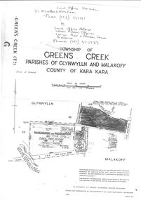
Photograph, Whitehall Property Greens Creek
Hutchings family 1. Wimmera River in flood below Whitehall running a banker c. 1920. Ted & Col Hutchings in foreground. 2. Wimmera River in flood looking downstream. No date but possibly same time as no. 1. from same place. 3. Looking over the Wimmera River to Island paddock towards Greens Creek 4. Wimmera River half a banker at Whitehall 5. Wimmera River in flood upstream from carpenter's shop looking towards engine house at Whitehall 5a. Wimmera River in flood. Left to right - blacksmith shop and carpenters' shop. 5b. Taken from the same spot with Emily & Ada Hole, E G (Ted) & Col Hutchings. Blacksmith shop & carpenters' shop, Whitehall. 5c. Wimmera River upstream from the carpenters' shop. Foreground is possibly Belladonna lilies which were all over the river bank in 1992. Whitehall. 5d. Looking downstream towards the loose boxes, Whitehall. 5e. Blacksmiths' shop and carpenters' shop from the pumping station. Wimmera River, Whitehall. 6. Wimmera River in flood at Whitehall. 7. Wimmera River half a banker in front of old hut at Whitehall. 8. Wimmera River Emily Hayes, Edward G (Ted) Hutchings & Colin J Hutchings. 9. Morrl-Morrl - Greens Creek Road opposite back paddock. Whitehall. Black Ford in distance. c. 1919 10. Whitehall woolshed north east aspect, Drive to the right of photo 11. Whitehall woolshed - north east aspect showing the drive to the right 11a. Whitehall woolshed - north aspect 11b. Same tree near woolshed 11c. Same tree again in centre, other trees came up after the 23 flood. Woolshed to the right out of photo. 12. Whitehall woolshed - south aspect, sheep entrance end 13. Whitehall. left to right, Stackyard, stables in the centre and the Wimmera River behind following the trees. 14. Whitehall horse paddock c. 1920. left to right, Machinery shed, stable in the centre. Homestead to the right in distance. There is no windmill. 15. Load of wool from Whitehall woolshed to right. 16. Whitehall c. 1920 before the windmill. left to right, garage and mens' hut. Wimmera river runs along the tree line. 16a. Stables, garage and mens' hut after the construction of the windmill. River behind. 17. Whitehall c. 1922. Note windmill addition. Garage to left, Mens' Hut to right. Jack Donnelly & Edward G (Ted) Hutchings with pet lambs. River behind trees. 18. Whitehall gardens. Summer house to the right, pine tree lined drive in the centre background. Ted & Col Hutchings on the lawn. C. 1920 19. Edward G. (Ted) & Colin J. Hutchings in Whitehall garden. Wimmera River in the background. The building behind the fence is the carpenters' shop which the family lived in while house was rebuilt after fire 15 Jan 1877 20. Whitehall c. 1920. left to right, cattle yard, killing house, Wimmera river behind the fence, and the loose box on the right. Black Orpington chooks in foreground. 21. Bay window (original blinds) in the master bedroom. Whitehall 20 Sep 1992 22. Master bedroom (original wallpaper) Joyce & Col Hutchings, Moyu, Ben & Rebecca Roe 20 Sep 1992 23. Col & Ted's bedroom (original) Marble mantlepiece had been removed. Whitehall. 20 Sep 1992 24. Whitehall kitchen. Large yellow meat oven to left of stove, bread oven far left, extreme right is oven where milk heated to skim cream. Chimney was a central one shared with meat oven. Bread oven chimney separate. 20 Sep 1992 25. Whitehall dairy, made of natural stone with dried brick corners. Entrance behind creeper which is over trellis. 20 Sep 1992. This building still remains in 1 Jun 2023 26. Inside charcoal lined meat cellar. Bottom right is concrete vat for pickling meat in brine. Top of brickwork slightly above ground level. Whitehall 20 Sep 1992 27. Fire foreground was stable flooring which was to left of photo. Machinery shed (thatch roof). 4 posts far left remains of cowshed. Large post in centre foreground is the gate post of corral. River to right. 20 Sep 1992 28. Whitehall machinery shed. Posts on far right are cow shed. Over the river is the island paddock. Wimmera river runs behind machinery shed. 20 Sep 1992 29. Posts of 10 sided corral. Killing house by side of gum tree in centre of photo on far side of corral. To left is one of the bales of the cowshed. Whitehall. 20 Sep 1992 29a. Similar photo in the 1920's. To the right is horsebreaking corral, then cow shed, loose box, haystacks and stable on left. Whitehall. 30. Dining room fire place put in the open fire of the mens' hut, only the chimney remains. To the left is the drive & river. Rebecca Roe, Col Hutchings granddaughter. 20 Sep 1992 30a. Looking down the Whitehall Drive. Mens' Hut (Jack Donnelly in doorway) and garage far left. 1920's 30b. The Drive, Whitehall taken from in front of the mens' hut. Wimmera River on the left. Gum tree on left still there 20 Sep 1992. 30c. Reverse from 30a. Whitehall drive from the front gate looking towards the mens' hut and garage. c. 1926 30d. Curly Donohue leaving for Warracknabeal. Ex mail contractor Omeo to Bright Victoria. C. 1926 30e. Looking down the drive towards front gate. Mens' hut on the right, river on the left. 31. Whitehall from the side. Building in centre behind David is separater room. 2 roomed hut to left of separater room and remains of mens' hut chimney. Photo 16 taken from similar spot. 20 Sep 1992 32. Benjamin Roe (Col Hutchings grandson) in the Carpenters' shop. The family lived in this building after the fire in the 1870's. Whitehall 20 Sep 1992 33. Ford across the Wimmera River at Whitehall (River abt. 5 feet higher than normal) 20 Sep 1992 33a. Wimmera River, Whitehall 34. Site of old bridge before Col Hutchings time. Tree in foreground to right still has bolt from bridge work protuding. A large post was in the centre of photo to make equal distance. 20 Sep 1992 35. Entrance to the old ford. Colin J Hutchings & his daughter, Moyu Roe. Wimmera River, Whitehall 20 Sep 1992 36. Summer house at Whitehall 20 Sep 1992 looking down to the orchard, dark green trees in distance old fruit trees. 36a. Edward & Colin Hutchings in front of the Summer house, Whitehall c. 1921 36b. Summer house looking towards front gate. Whitehall. 36c. Grey thrush in nest box which can be seen in previous photo with summer house in the background. Whitehall. 36d. Summer house from the orchard side. Whitehall. 37a. South side of Whitehall. First window Edith Sutherland's room, 2nd window, Ted & Col's room, bay window master bedroom 38. Taken in middle of front path looking towards front gate. Edith Sutherland in garden. Date palm in centre, cotton palm to left. Whitehall c. 1920's 38a. Garden at Whitehall taken from near the cotton palm. 39. Whitehall 20 Sep 1992 Bay window-master bed, small window to r. of bay-Colin Hutchings born in, front door, window to right-dining room, round the corner- drawing room, window on right, spare bed, verandah on left is spare bed. 39a. Whitehall c. 1920's Date palm on the right. 39b. Win, Colin T & Colin J Hutchings. Date palm in background. Whitehall 1943 39c. Edward George, Colin Thomas, Elizabeth Ambler & Colin James Hutchings wearing RAAF uniform. Date Palm in background. Whitehall c. 1943 39c. Front garden of Whitehall looking from the front right side of the house towards the drive & Wimmera River. Date palm on right, cotton palm on left 20 Sep 1992 40. Taken from bottom left corner of front garden looking towards the summer house. Cotton palm on right. River to the left. 41. Elizabeth A Hutchings beside master bedroom window. Whitehall c. 1920 42. Whitehall (photo of a painting by Wallace) owned by Colin T Hutchings 1982. 42a. Whitehall painting by Wallace after restoration now owned by Nick Hutchings 2021 42b. Whitehall c. 1923 42c. Taken from the side garden looking towards the right side of house. Front door is to the left out of photo. The cotton palm is to the left. c. 1923 43. Signpost showing Whitehall 20 Sep 1992, All ground up to the tree line behind the signpost was Whitehall property. 44. Colin T. Hutchings age 9 mths. Mar 1943 Whitehall 45. Colin James, Elizabeth Ambler & Edward George Hutchings. Front garden by the date palm, Whitehall c. 1939-40 45a. Colin James, Edward George, Edward Thomas Hutchings & E. Winifred May & Barney (dog) Whitehall. c. 1939-40. 45b. Colin James & Colin Thomas Hutchings during drought & World War ll c. 1944-45 in front of cotton palm, date palm to right. 46. Garden at Whitehall. Jack Donnelly on the hand mower. Cotton palm on left, date palm behind Jack and roof of carpenters shop to right. 47. Colin J Hutchings on tractor, E. Tom Hutchings behind. Whitehall, c. 1933 48. Jack Donnelly (Tad) & Colin J. Hutchings. Cotton palm to right. Whitehall c. 1917-18 49. Edward G (Ted) & Colin J Hutchings with cockatoo outside the dairy in rear garden. Whitehall c. 1923 50. Taken from the windmill looking across the roof of the mens' hut to the garden, orchard and drive in Winter time. House is behind the trees to right, Wimmera River to the left out of picture. Whitehall. 50a. Not labelled by Col Hutchings. It is an aerial shot looking towards the house in the trees & seems to be taken from the top of a tree...on the river side. 51. E. Tom Hutchings & George Chambers dam sinking. Whitehall. 51a. Tom Hutchings & George Chambers dam sinking. Whitehall. 51b. E. Tom Hutchings dam sinking. 52. Emily Hayes & Ada Hole (sisters) with Tom, Col & Ted Hutchings at the woolshed. 53. E T (Tom) Hutchings on reaper & binder. Whitehall. 54. Orchard looking towards the house. Carpenters' shop and river on the right. Whitehall. 54a. Orchard looking from the house, dark trees in background form part of the drive. 55. Grasshopper plague, Christmas Day 1933. Whitehall 56. Frost on the front lawn, Whitehall. 57. Little red hen & chicks with the river in the background 58. Edward (Ted) G. Hutchings muscovy ducks, hay shed and trees along the river in the background. 58a. Edward (Ted) G Hutchings muscovy ducks. 59. Swimming in the Wimmera River, either Ted or Col Hutchings in the foreground. 60. Looking towards the fowl house and pigsty, Whitehall. 61. Snake on the path, Whitehall. c. 1923 61a. E. Tom Hutchings killing a snake, Whitehall. c. 1923 61b. E. Tom Hutchings killing a snake, Whitehall. c. 1923 62. Notice of clearing sale, Stawell News & Pleasant Creek Chronicle on 5 Apr 1916 where the stock & whole of the household furniture was to be sold by James Hutchings widow. 63. Back to Greens Creek 7 Jun 1987 Colin J Hutchings left and Belle Kindred centre looking at photo 64. Back to Greens Creek 7 Jun 1987 Colin J Hutchings centre, Graham Stewart holding photograph on the right. 65. Colin J Hutchings & Bill Walker. Back to Greens Creek 7 Jun 1987 66. Colin J Hutchings delivering a speech before the plaque unveiling. Back to Greens Creek 7 Jun 1987 67. Graeme Williamson & Colin J Hutchings (2 'old boys') Greens Creek School Site 7 Jun 1987 68. Graeme Williamson talking to Moyu Roe (Hutchings) in background is May Williamson. Back to Greens Creek 7 Jun 1987 69. Greens Creek SS, Edward (Ted) & Colin J Hutchings attended. 70. Original students of first Greens Creek School 7 Jun 1987 Back row left 1. Kindred 3. Colin J Hutchings 4,5,6 not known 7. Graeme Williamson Sitting left 1. Not an original 2,3,4, not known 5. Belle Kindred 71. Terrier at Greens Creek State School 72. The new school students Back to Greens Creek 7 Jun 1987. Perry twins standing in centre and the teacher kneeling front left. 73. Will Rees water colour 1925 signature 74. Will Rees water colour 1925 75. Shearing at Kirkellar. Allen Simpson's 76. Back to Greens Creek 7 Jun 1987 Colin J Hutchings left and Belle Kindred centre looking at photo 77. Back to Greens Creek 7 Jun 1987 Colin J Hutchings centre, Graham Stewart holding photograph on the right. 78. Colin J Hutchings & Bill Walker. Back to Greens Creek 7 Jun 1987 79. Colin J Hutchings delivering a speech before the plaque unveiling. Back to Greens Creek 7 Jun 1987 80. Graeme Williamson & Colin J Hutchings (2 'old boys') Greens Creek School Site 7 Jun 1987 81. Graeme Williamson talking to Moyu Roe (Hutchings) in background is May Williamson. Back to Greens Creek 7 Jun 1987 82. Greens Creek SS, Edward (Ted) & Colin J Hutchings attended. 83. Original students of first Greens Creek School 7 Jun 1987 Back row left 1. Kindred 3. Colin J Hutchings 4,5,6 not known 7. Graeme Williamson Sitting left 1. Not an original 2,3,4, not known 5. Belle Kindred 84. Shearing at Kirkellar. Allen Simpson's 85. Terrier at Greens Creek State School 86. The new school students Back to Greens Creek 7 Jun 1987. Perry twins standing in centre and the teacher kneeling front left. Digital Copy of Parish Maps Kara Karahomestead -
 Ballarat Tramway Museum
Film - Movie Film & Box, Kodak, 1960
Yields information in movie film format of Ballarat trams in 1960, how the system operated and was used by people., Yields information in movie film format of Ballarat trams in 1960, how the system operated and was used by people.Movie film - 8mm, approx. 30mins, with leader strip on a plastic reel, within a black and white plastic box, titled "Ballarat No. 1. 1960". Has been transferred to DVD - see Reg item 4100 as Segment No. 2. Made by Ben Parle. Also transferred to DVD by Rod Cook Oct. 2015, via Roger Greenwood for use in his DVD, "The City of Ballarat Trams, Gardens & Gold" of 2016. See Reg Item 6883. Synopsis: based on time. 0:00 View of typed introduction, noting that this is a pictorial record of Ballarat. 0:10 Title “The Tramways of Ballarat 1960, Part 1” 0:16 13, showing “View Point” at Stones Corner, Bridge St, east end, with trolley pole being turned, while another single trucker heads out towards Mt Pleasant. 0:25 13 leaving Stones Corner, short approach and then longer trailing shot of the tram going towards the City in Bridge St. 0:44 View out of front of tram in Bridge St heading towards the City, with cars in the photo, then passing through city Loop, no trams in the loop and running up to Lydiard St Nth and crossing the road. 1:22 Running up Sturt St from Armstrong St, passes over Dawson St X-over and up to the next intersection, Lyons St. 1:54 Title “The View Point Line” 1:59 19 inbound, in Ripon St, from crossing Mair St, towards camera and then passing away and turning into Sturt St. 2:49 View of a “Warning Oncoming Trams” sign 2:52 19 in Ripon St, going to View Point, crossing Webster St towards camera, then going away through the disconnected Victoria Ave loop, pass the “Warning Oncoming Trams” sign. Note very windy scene with people running across roads. 3:17 19 in Wendouree Parade, in bound, though showing destination View Point, going away from the camera, past the View Point Hotel. 3:39 19 coming towards camera near Excerpt or Devon St and then going away towards the terminus. 4:04 19 at the terminus, stationary, with a single trucker 3?, passing from Macarthur St into Wendouree Parade, behind 19. 4:20 33 coming towards camera in Wendouree Parade from St Aidans Drive, stopping to pick up passenger at Forest St and then going away towards the City, photographed from near the depot, on a wet and windy day. 4:54 35 in Wendouree Parade, coming towards the Camera from St Aidans Drive and then going away with the Gardens Loop area in the background. Tram stops at stop to let a passenger off. 5:28 21 leaving Gardens Loop for the City via the Depot, green light in signal can be seen. 5:43 28?, closely followed by 26 turn from Drummond St South into Sturt St. 6:18 Scene opens with shot of “Sebastopol” destination on a bogie tram. 6:21 Title “The Sebastopol Line” 6:24 21 turning from Sturt St into Drummond St Sth with destination of Bell St and then going away from the camera. 6:55 38 in Drummond St Sth, coming towards the camera and then passing the camera with Sturt St just in the view. 7:10 21, showing Gregory St, in Drummond St Sth, approaching and then going away, entering the Urquhart St Loop, 7:39 34 in Drummond St Sth (location check required (Latrobe?)), approaches camera, picks up passengers and the goes away. 8:09 39 at ? Street, turns from Drummond St Sth into Skipton St, after picking up and setting down passengers, bound for Sebastopol 8:55 35 inbound in Skipton St passes through the Bell Street Loop, and then goes away from the camera. 9:33 42 outbound in Skipton St, approaches the camera, passes and then crosses over the half the road into Albert St. 10:00 39 inbound in Albert St – location? 10:31 34 outbound for Sebastopol, approaches camera and just starts to pass by. 10:36 34 in Grey St crossing loop, crosses 42 inbound. 10:59 39 outbound in Albert St, with shopping centre in bound, approaches camera, passes and then crosses over Albert St. Mid morning scene. 11:39 39 inbound, Albert St south, approaches camera and then passes and the crosses over Albert St. 12:16 41 outbound in Albert St passes the camera, and pulls into the terminus with the conductor getting out on the back bumper to pull the pole down as the tram stops and a passenger walks into the Royal Hotel. 12:39 Title “The Lydiard Street North Line” 12:44 Filmed from the Hotel balcony, 21 inbound in Lydiard St Nth passes over Mair St, stops while 33 passes in the other direction. 13:18 With the red light showing on the Seymour St loop signal, 33 inbound for Sebastopol stops and picks up many passengers, passes the camera and runs past the VRI building in the background and through the loop. Possibly filmed on a Sunday given the ladies dresses and quieter streets. 14:01 30 outbound, passes the camera and stops at Macarthur St. Filmed alongside the brick wall of the cutting. 14:28 30 inbound arrives, passes through the Gregory St loop and then proceeds past the camera, making a stop to pick up passengers. 15:14 28 in Lydiard St Nth – location?, approaches and goes away from the camera, north of Gregory St. 15:34 28 ditto location? 15:53 21 arrives at the terminus with passengers getting on and off. 16:11 View of the a vertical positioned “End of Section” sign on a pole at the terminus and then lifting the camera to see the timetable board and the stop sign. 16:33 31 in Bridge St passing Morseheads and then turning into Sturt St, stops at the Grenville St stop, while another single trucker comes down to the stop from the City. 16:58 31 outbound in Bridge St, with destination of Victoria St. 17:14 Title “The Victoria Street Line” 17:18 31 outbound to Victoria St from Stones Corner. Starts with an overhead shot, shows clock at the Caltex service station,. 17:37 31 inbound approaching Bakery Hill and then descending to the junction after it passes camera. 18:09 25 climbing outbound in Victoria St, passing the camera, to then pass through the King St loop. 18:47 25 inbound in Victoria St, passing the camera, then pass through the King St loop, with St Alypius Church in the background. 19:36 14 approaching the rail bridge in Victoria St and stopping at the 2nd last stop to left of passengers. 20:01 14 leaving the terminus and approaching the camera and the a short sequence going away, to the next stop to pick up quite a few passengers. 20:14 “Trams Stop Here” sign, metal wrap around on a steel pole. 20:16 Title “The Mount Pleasant Line” 20:21 11 inbound in Main St, with a passenger leaping off the tramcar and another getting off just before the junction. 20:45 11 passes the junction and then proceeds away from the camera in Bridge St. 21:04 30 outbound in Main St, then turns into Barkly St, a bus (Eclipse Motors) passes in Main St just before the sequence ends. 21:31 30 inbound near Steinfield St. (exact location?) 21:49 25 approaches the camera, then proceeds away and passes through the Grant St. loop. 22:29 25 inbound, windy day, between Grant and Cobden, (exact location?), with a horse drawn bread van in the view and the breadman walking behind the tram as it passes. 23:02 11 outbound in Barkly St, (exact location?) 23:37 11 inbound in Barkly St (exact location?) 23:44 Mt Pleasant terminus signage 23:50 30 approaches the terminus and then stops with the conductor alighting turning the pole, passengers getting on and off and the driver appearing at the other end. 24:32 Title “The Gardens Via Sturt St. West Line” 24:35 21 outbound in Sturt St near Raglan St, approaches and passes the Camera. 25:09 12, showing City Oval, approaches and passes the camera, outbound near Windermere St. 25:33 13 showing View Point, goes away from the camera – location? 25:44 12 comes from St. West, inbound passes the camera and then stop as the next stop next Talbot St? 26:21 Short sequence of a “Warning Oncoming Trams” sign 26:28 42 inbound in Sturt St West, just before Ripon St, view coming towards camera and then going away to cross Ripon St. 27:10 34 passes through the Parker St loop 27:25 35 or 39 inbound past the college in Sturt St West 28:04 41 outbound at the Russell St curve, passes away from the camera. 28:11 35? inbound passes away from the camera through the Victoria Park or Morrison St loop, swinging out into the roadway. 28:29 View of timetable sign at Hamilton Ave. 28:37 35 turning from Sturt St West into Hamilton Ave, can see the conductor changing over the barrier rails. 29:11 42 inbound, crosses another bogie tram (35?) at Carlton St loop then passes the camera and goes past the Olympic rings monument. 29:42 12 approaches the Carlton St gates. 30:07 12 outbound, crosses a bogie tram in the loop with both trams then leaving the loop. 30:20 Title “End of Part One” Written labels giving title information on outside of box.trams, tramways, ballarat, sebastopol, lydiard st north, victoria st, mt pleasant, sturt st west -
 Ballarat Tramway Museum
Album - Postcards & Photographs - Vic Solomons and others - Australian Tramways, Vic Solomons, 2023
Contains 184 images of postcards and photographs collected primarily by Vic Solomons of Sydney, with others from the collection of Wal Jack and Warren Doubleday. Covers almost all of Australia's tramway systems. 1 Post Card Hay St Perth Looking East No 3 Unknown Perth 2 Post Card Cars 30 & 90 both on Route 19 pass in Barrack St looking South Perth WA 1935.02.18 Perth 3 Post Card Hay St Looking East Perth WA Unknown Perth 4 Post Card William St Perth WA Unknown Perth 5 Post Card Perth from Shaftsbury Hotel Unknown Perth 6 Post Card Hay St Perth WA Looking East Unknown Perth 7 Post Card Barrack St Perth Unknown Perth 8 Post Card Murray Views No 3 High St Showing Town Hall Fremantle WA Unknown Fremantle 9 Post Card High St Fremantle WA Unknown Fremantle 10 Post Card View of Bolder City Golden Mile in the Background (Section No 1) 1908.08.20 Kalgoolie 11 Post Card Hannan St Kalgoolie 1900.08.19 Kalgoolie 12 Post Card Hannan St Kalgoolie WA (No 2) Unknown Kalgoolie 13 Post Card Intersection Hannan & Maritana Sts Kalgoolie WA Unknown Kalgoolie 14 Post Card Hannan St Kalgoolie Unknown Kalgoolie 15 Post Card Lane Street Bolder City Unknown Kalgoolie 16 Post Card Hobart Double Deck Tram Unknown Hobart 17 Post Card Macquarie St Hobart Unknown Hobart 18 Photo Liverpool Street Hobart Unknown Hobart 19 Photo Hobart 21 Unknown Hobart 20 Photo Hobart 14 in Elizabeth St Hobart Unknown Hobart 21 Post Card Macquarie St Hobart Unknown Hobart 22 Post Card Macquarie St Hobart Tas Unknown Hobart 23 Photo Double Decker Tram 3 at G.P.O. Hobart Tas No 31 Unknown Hobart 24 Post Card Double Decker Tram 19 Hobart Tas A B Series No 24 Unknown Hobart 25 Photo Hobart Municipal Tramways Tas No 95 Unknown Hobart 26 Post Card Elizabeth St Hobart Unknown Hobart 27 Post Card Elizabeth St Hobart Unknown Hobart 28 Post Card Elizabeth St Hobart Unknown Hobart 29 Post Card Elizabeth St Hobart Tas Unknown Hobart 30 Post Card HMT 21 with crew at Beach Road Terminus Unknown Hobart 31 Post Card HMT 9 & another with crew at Beach Road Terminus. Front cover photo of Destination GPO 1921.01.00 Hobart 32 Post Card Cascade Road and Mount Wellington Hobart Unknown Hobart 33 Post Card Elizabeth St Hobart Unknown Hobart 34 Post Card Elizabeth St Hobart Unknown Hobart 35 Post Card Elizabeth St Hobart 1915.04.07 Hobart 36 Post Card Macquarie St Hobart Tas Unknown Hobart 37 Post Card Macquarie St showing Post Office Hobart 1908.03.12 Hobart 38 Post Card Hobart Municipal Tramways 21 Unknown Hobart 39 Post Card Elizabeth St Hobart Tas Unknown Hobart 40 Post Card Liverpool Street Hobart Unknown Hobart 41 Post Card Electric Tram Launceston Tas 446 W J Little Photo 1919.02.08 Launbceston 42 Post Card Launceston Tram no 3 1911.08.30 Launbceston 43 Post Card Launceston Tram no 3 passes tram No 1 Unknown Launbceston 44 Post Card Tram 6 at Trevallyn a popular suburb Launceston Tasmania Unknown Launbceston 45 Post Card Tram 7 at Trevallyn Road Terminus Launceston Tasmania Unknown Launbceston 46 Post Card Tram 4 in Brisbane St Launceston Unknown Launbceston 47 Post Card Tram 9 in Brisbane St Launceston Tasmania Unknown Launbceston 48 Post Card Camerom Street Launceston Tasmania Unknown Launbceston 49 Post Card Murray Views No 15 Jetty Road Glenelg Terminus 1962-02-08 Adelaide 50 Post Card Bay Tram at Jetty Road Terminus Glenelg SA Unknown Adelaide 51 Post Card Tram 3 in King William Street Adelaide S Aust Unknown Adelaide 52 Post Card Valentine Series No 3065 The Old Horse Tram Victor Harbour Unknown Victor Harbour 53 Post Card Bourke Street Melbourne with Cable Car Looking East 1904.04.25 Melbourne 54 Post Card Opening of New Electric Tramway Elsternwick 1913-11-13 Melbourne 55 Post Card Cable trams in Clarendon St Sth Melb Unknown Melbourne 56 Post Card Pall Mall from Charing Cross Bendigo Unknown Bendigo 57 Post Card Tram 4 & 7 pass at The Fountain and Mitchell Street Bendigo Vic Rose Series P 3198 Unknown Bendigo 58 Post Card M&MTB 133 at Charing Cross bound for Eaglehawk Bendigo Vic Murray Views No 45 Unknown Bendigo 59 Post Card Pall Mall Bendigo Vic Unknown Bendigo 60 Post Card Charing Cross & Mitchell St Bendigo Trams passing 1919.00.00 Bendigo 61 Post Card Pall Mall Looking East Unknown Bendigo 62 Post Card Electric Trams and City Hotel Bendigo Vic Unknown Bendigo 63 Post Card Moorabool Street Geelong V 23 Unknown Geelong 64 Post Card Murray Views No 3 Moorabool Street Geelong Vic Unknown Geelong 65 Post Card The Rose Series P 2487 Ryrie Street Geelong Vic Unknown Geelong 66 Post Card Southern Cross Series 2696 Ryrie Stret Geelong Vic Unknown Geelong 67 Post Card The Rose Series P 1490 Ryrie Street Geelong Vic 1920-03-04 Geelong 68 Post Card Valentine Series No 1568 Lower Sturt Street Ballarat Unknown Ballarat 69 Post Card Rose Series P 1710 Sturt Street Ballarat Victoria Unknown Ballarat 70 Post Card Sturt Street Ballarat Victoria Unknown Ballarat 71 Post Card Horse Tram In Sturt Street Ballarat 1905.11.10 Ballarat 72 Post Card Sturt Street Ballarat Looking North-West Unknown Ballarat 73 Post Card Shoppes Square Sturt Street Ballarat Looking North Unknown Ballarat 74 Post Card Junction Sturt and Lydiard Streets Ballarat 1909-09-01 Ballarat 75 Post Card The Electric Supply Co Souvenir Tram Ticket No 3085of the opening of Electric System August 18 1905 1905.08.18 Ballarat 76 Post Card Sturt Street Ballarat Victoria 1907.11.25 Ballarat 77 Post Card Off to the Gardens Electric Tram Ballarat Unknown Ballarat 78 Post Card Sturt Street Ballarat 1907.04.16 Ballarat 79 Post Card Sturt Street Ballarat Looking East Electric tram with Double Deck Trailer 1911.04.17 Ballarat 80 Post Card Sturt Street Ballarat Looking East Unknown Ballarat 81 Post Card Sturt Street Ballarat Looking West 1911.03.01 Ballarat 82 Post Card Town Hall and Sturt Street Ballarat Unknown Ballarat 83 Post Card Lydiard Street Ballarat 1906.11.23 Ballarat 84 Post Card Looking North along Adelaide Street from George Street Brisbane Sidues Series No 764 Unknown Brisbane 85 Post Card Looking South along Queen Street from the Creek Street Intersection Brisbane Qld Sirues Series No 1379 Unknown Brisbane 86 Post Card George Street from near Supreme Court Brisbane Unknown Brisbane 87 Post Card Queen and Eagle Streets Brisbane 1907.07.04 Brisbane 88 Post Card Queen Street showing His Majesty’s Theatre Brisbane Unknown Brisbane 89 Post Card Queen Street Treasury Building 1908.01.20 Brisbane 90 Post Card G P O and Queen Street Brisbane Unknown Brisbane 91 Post Card Queen Street Brisbane Looking from Wharf Street Unknown Brisbane 92 Post Card Customs House Brisbane 1905.02.16 Brisbane 93 Post Card Queen St Brisbane 1905.09.16 Brisbane 94 Post Card Queen St Brisbane 1907.11.19 Brisbane 95 Post Card Treasury Buildings Brisbane Unknown Brisbane 96 Post Card Queen and Eagle Streets Brisbane Unknown Brisbane 97 Post Card The Valley Corner Brisbane Unknown Brisbane 98 Post Card Brisbane Queen Street opposite General Post Office Unknown Brisbane 99 Post Card North Quay and Milton Beach Brisbane Q Unknown Brisbane 100 Post Card Victoria Bridge Brisbane South Side 1907.08.14 Brisbane 101 Post Card Victoria Bridge Brisbane Unknown Brisbane 102 Post Card Breakfast Creek Bridge Brisbane Q Unknown Brisbane 103 Post Card Melbourne Street Station South Brisbane Queensland Unknown Brisbane 104 Post Card General Post Office Queen Street Brisbane 1955.09.23 Brisbane 105 Post Card Customs House Brisbane 1904.11.04 Brisbane 106 Post Card Queen St Brisbane 1919.11.00 Brisbane 107 Post Card Queen St Brisbane Sidues Series No 627 Unknown Brisbane 108 Post Card Creek Street Brisbane Queensland Unknown Brisbane 109 Post Card Customs House and Garden Reach Brisbane Queensland 1910.00.08 Brisbane 110 Post Card Queen and Creek Streets Brisbane 1909.06.07 Brisbane 111 Post Card Queensland National Bank andd Queen Street Brisbane Queensland Unknown Brisbane 112 Post Card Queen Street and Treasury Buildings Brisbane 0000.09.07 Brisbane 113 Post Card Queen Street showing “Courier” Buildings Brisbane Unknown Brisbane 114 Post Card Intersection George & Roma Streets Brisbane Q 1916.05.11 Brisbane 115 Post Card Adelaide Street Brisbane Q Unknown Brisbane 116 Post Card G P O Queen Street Brisbane Q Unknown Brisbane 117 Post Card Treasury Building Brisbane 1906.03-20 Brisbane 118 Post Card Queen and Eagle Streets Brisbane 1907.02.01 Brisbane 119 Post Card Queen St Brisbane Unknown Brisbane 120 Post Card Queen St Brisbane Q Unknown Brisbane 121 Post Card Victoria Bridge Brisbane 1906.07.30 Brisbane 122 Post Card An Unusual View showing Head of Queen Street Victoria Bridge & South SideSuburbs Brisbane Q Unknown Brisbane 123 Post Card Petries Bight Brisbane Q Unknown Brisbane 124 Post Card South End Victoria Bridge Brisbane Q Unknown Brisbane 125 Post Card Customs House Brisbane Unknown Brisbane 126 Post Card Photo of toastrack car circa 1910 Unknown Brisbane 127 Post Card Treasury Buildings Brisbane Unknown Brisbane 128 Post Card East Street Rockhampton with Steam Tram & trailer Unknown Rockhampton 129 Post Card Post Office Rockhampton with steam tram Unknown Rockhampton 130 Post Card East Street Rockhampton with Steam Trams Rose Series P 7154 Unknown Rockhampton 131 Post Card William Street Rockhampton Rose Series P 7156 Unknown Rockhampton 132 Post Card Central East Street Rockhampton Q with Steam Trams Unknown Rockhampton 133 Photo Sturt St Ballarat Unknown Ballarat 134 Photo Bridge Street Ballarat Unknown Ballarat 135 Post Card George St Sydney Unknown Sydney 136 Post Card Elizabeth St Sydney Unknown Sydney 137 Post Card Railway Square Unknown Sydney 138 Post Card Sydney Harbor Bridge - pending receipt 139 Post Card Kings Cross - Mowbray Series with description on rear from C Roy G Field Unknown Sydney 140 Post Card Kings Cross - Mowbray Series with description on rear from C Roy G Field Unknown Sydney 141 Post Card Central Railway Station Sydney - Rose Series P6033 1954-01-26 Sydney 142 Post card William Street Darlinghurst looking towards City - Rose Series P6602 unknown Sydney 143 Post Card Circular Quay Sydney - Rose Series P6680 Unknown Sydney 144 Post Card View at Manly NSW - Rose Series B1003 Unknown Sydney 145 Post Card Hunter St Newcastle NSW - Rose Series P7843 Unknown Newcastle 146 Post Card Bank Corner Newcastle NSW - Mowbray Series No. 155 Unknown Newcastle 147 Post Card Hunter St Newcastle NSW Unknown Newcastle 148 Post Card Criterion Hotel Hunter St Newcastle NSW Unknown Newcastle 149 Photo Horse tram at Newtown Station 1894 to 1898 - PTC photo c1894 Newtown 150 Photo Steam tram motor No 3 at Railway Square 1879 1879 Sydney 151 Photo Railway steam tram c1900 with a horse drawn double deck bus c1900 Sydney 152 Photo Steam motor 5A and doubled deck bus Unknown Sydney 153 Photo Steam motor 53A with detail notes on rear 1922 Sydney 154 Photo Cable tram set at Milsons Point ferry terminal c1900 Sydney 155 Photo Early Sydney electric car - Ocean St - Rose Bay Unknown Sydney 156 Photo George St looking souoth c1905 c1905 Sydney 157 Photo Tram 165 at Circular Quay Unknown Sydney 158 Photo Tramcar ferry or transporter at The Spit Unknown Sydney 159 Photo tram 882 George St at Marti Place, 1937 1937 Sydney 160 Photo Tram 826 Railway Sq area Unknown Sydney 161 Photo Railway Sq in background, Broadway with double decker bus and toastrack car late 1930s Sydney 162 Photo Coupled St Pitt St? - photo Ben Parle Feb. 1950 Sydney 163 Photo Electric tram No. 2 - North Sydney with side trolley pole running Unknown Sydney 164 Photo George St - Horden's Corner Unknown Sydney 165 Photo George St at Martin Place c1920 Sydney 166 Photo Castlereagh St Sydney c1928 c1928 Sydney 167 Photo Railway Sqare c1920 c1920 Sydney 168 Photo Darling St Countereweight Unknown Sydney 169 Photo Trolley bus depot Unknown Sydney 170 Photo Trolley bus No. 14 Unknown Sydney 171 Photo Newcastle Railway Station with steam tram - Wharf Road?? Unknown Newcastle 172 Photo High St West Maitland - steam tram Unknown Maitland 173 Photo High St West Maitland - steam tram Unknown Maitland 174 Post Card Argent St near tram terminal Broken Hill NSW c1900 Broken Hill 175 postcard Argent St looking south Broken Hill - with Ken Magor's notes on rear Unknown Broken Hill 176 Photo Toronto - steam tram 61A Unknown Toronto 177 Photo 124A trial run 1911? Sutherland - Cronulla line 1911 Sutherland 178 Photo 103A at a tram stop Unknown Sydney 179 Photo Cable tram set at Crows Nest terminus grip car 12, trailer 22 Unknown Sydney 180 Photo Cable tram Queens Square Sydney 1903 Sydney 181 Photo cars 2078 and 2077 Chatswood late 1950s Sydney 182 Photo car 1877 Balmain area late 1950s Sydney 183 Photo Trolley bus - Rockdale destination Late 1950s Sydney 184 Photo Broken Hill steam tram - motor 18A North Tram Unknown Broken Hill 185 Photo Millars Point Sydney NSW - ferry/tram interchange, unknown Sydney All items imaged including the rear or back where there was writing of information. All files stored on the Museum's Photo Collections directory. Demonstrates through the medium of many images, Australian tramway systems and Ballarat's place in them.Album - heavy card covers, plastic lined with postcard or 6x4 photo sleeves.australia, tramways, postcards, photographs, steam trams, horse trams, cable trams, trolley buses -
 Bendigo Military Museum
Photograph - Army Survey Regiment Freedom of Entry Parade, Queen Elizabeth Oval, Bendigo, 1980
The Freedom of Entry to the City was an honour conferred by the Bendigo City Council to the Army Survey Regiment in 1970. 1980 was the third time the unit exercised its freedom of marching into the city with swords drawn, bayonets fixed and drums beating. The honour is usually bestowed upon local regiments, in recognition of their dedicated service, and it is common for military units to periodically exercise their freedom by arranging a parade through the city. Led by the Regiment’s CO – LTCOL Bob Skitch, the unit marched down View St in the CBD, along Pall Mall and up Gaol Rd to the Queen Elizabeth II Oval. The ceremonial parade followed with a march past the guests of honour, Mayor of Bendigo Councillor Paul Tomkinson and military dignitaries. The parade concluded after formal inspections of the troops. The Regiment also exercised its Freedom of Entry with anniversary parades in 1977, 1980, 1985, 1990 and 1995. Some photos in this set were also printed on photo paper and catalogued under item 6021.25P. Photos of the march are catalogued under item 6491.19P. Photos of the Freedom of Entry parade rehearsal are catalogued under item 6479.38P.These black and white photographs of the Army Survey Regiment were taken on the occasion of the Freedom of Entry parade to the City of Bendigo in 1980. The photographs are on 35mm negative film and scanned at 96 dpi. They are part of the Army Survey Regiment’s Collection. .1) to .7) - Photo, black & white, 1980. Squadrons formed up at beginning of parade. .8) & .9) - Photo, black & white, 1980. 3rd Military District Band marches to their parade position. .10) to .11) - Photo, black & white, 1980. Squadrons formed up parade with 3rd Military District Band playing music. .12) to .14) - Photo, black & white, 1980. Officers formed up before taking posts. L to R: MAJ Peter Eddy, LT Brendon Jaego-Banks, CAPT Peter Searle - UK Exchange, unidentified, ADJT CAPT John Harrison, MAJ Sam Schwartz US Exchange, unidentified, MAJ Robin Blackburn, remainder unidentified. .15) - Photo, black & white, 1980. Officers march to their posts. L to R: MAJ Peter Eddy, LT Brendon Jaego-Banks, CAPT Peter Searle - UK Exchange, unidentified, ADJT CAPT John Harrison, MAJ Sam Schwartz US Exchange, unidentified, MAJ Robin Blackburn, remainder unidentified. .16 - Photo, black & white, 1980. Officers march to their posts. .17 - Photo, black & white, 1980. Army Svy Regt awaits the arrival of the Mayor – Councillor Paul Tomkinson. .18 - Photo, black & white, 1980. CO LTCOL Bob Skitch escorts the Mayor – Councillor Paul Tomkinson and unidentified guest to the dais. .19) to .25) – Army Svy Regt salutes the Mayor – Councillor Paul Tomkinson. .26) - Photo, black & white, 1980. CO LTCOL Bob Skitch escorts the Mayor – Councillor Paul Tomkinson to Headquarters Squadron to inspect its personnel. .27) - Photo, black & white, 1980. Headquarters Squadron inspection. L to R: OC MAJ Paddy Strunks, RSM WO1 Aub Harvey, Mayor – Councillor Paul Tomkinson, SPR Chris ‘Charlie’ Brown, unidentified, SGT John Grove (orderly room), unidentified, SPR Jeff Ruiz, WO2 Max Neil, unidentified, SGT Alan Brown, SGT Tim Allanson. .28) - Photo, black & white, 1980. Headquarters Squadron inspection. L to R: OC MAJ Paddy Strunks, Mayor – Councillor Paul Tomkinson, unidentified, SGT Rick Warren, unidentified, CPL Andy Wilson, WO2 Ted Burgess. .29) - Photo, black & white, 1980. Headquarters Squadron inspection. L to R: OC MAJ Paddy Strunks, RSM WO1 Aub Harvey, unidentified civilian, Mayor – Councillor Paul Tomkinson, unidentified, SGT Rick Warren, unidentified, CPL Andy Wilson, WO2 Ted Burgess. .30) - Photo, black & white, 1980. Cartographic Squadron’s OC CAPT Bob Roche salutes the Mayor – Councillor Paul Tomkinson. L to R: unidentified civilian, CO LTCOL Bob Skitch. In background L to R: SSGT Bob Scaddan, unidentified, CPL John Tempest, CAPT Simon Lemon, SSGT Colin Cuskelly, CPL Trevor Bottomley, SPR Bob Sheppard, WO2 Bob ‘Stretch’ Hayden, unidentified, CPL Ian McKenzie, FLTLT Ron Aitken, SPR Ian Fitzgerald, SPR Greg Else. .31) - Photo, black & white, 1980. Cartographic Squadron’s OC CAPT Bob Roche salutes the Mayor – Councillor Paul Tomkinson. L to R: unidentified civilian, CO LTCOL Bob Skitch. In background L to R: CPL Terry Danger, SPR Rod Skidmore, SSGT Bob Scaddan, unidentified, CPL John Tempest, CAPT Simon Lemon, SSGT Colin Cuskelly, CPL Trevor Bottomley, SPR Bob Sheppard, WO2 Bob ‘Stretch’ Hayden, unidentified, CPL Ian McKenzie, FLTLT Ron Aitken, SPR Ian Fitzgerald, SPR Greg Else. .32) - Photo, black & white, 1980. Cartographic Squadron inspection. L to R: OC CAPT Bob Roche, Mayor – Councillor Paul Tomkinson. In background L to R: SGT Stu Thaxter, unidentified, SSGT John Barrie, CPL Roger Pearson, SGT Doug Carswell, SPR Peter Main, WO2 Bob ‘Stretch’ Hayden. .33) - Photo, black & white, 1980. Cartographic Squadron inspection. L to R: CO LTCOL Bob Skitch, OC CAPT Bob Roche, unidentified civilian, SGT Doug Carswell, Mayor – Councillor Paul Tomkinson, WO2 Bob ‘Stretch’ Hayden. .34) - Photo, black & white, 1980. Female Contigent inspection L to R: unidentified, SPR Gae (Amato) Robinson, SPR Scheryl Delforce, unidentified officer, unidentified civilian, Mayor – Councillor Paul Tomkinson, CPL Marrianne (Van De Zee) De Groot, SPR Cathy Regan, SPR Ginny (Turner) Rowe, SPR Ilen Isaac, SPR Penny Knott, SPR Santina (Argetto) Straube, SPR Gina (Coore) Neilson, WO2 Pat Lumsden. .35) - Photo, black & white, 1980. Female Contigent inspection L to R: SPR Scheryl Delforce, unidentified officer, CO LTCOL Bob Skitch, unidentified civilian, Mayor – Councillor Paul Tomkinson, SPR Ginny Turner, SPR Ilen Isaac, SPR Penny Knott, SPR Santina (Argetto) Straube, SPR Gina (Coore) Neilson, WO2 Pat Lumsden. .36) - Photo, black & white, 1980. Female Contigent inspection L to R: SPR Scheryl Delforce, unidentified officer, CO LTCOL Bob Skitch, unidentified civilian, Mayor – Councillor Paul Tomkinson, SPR Cathy Regan, SPR Ginny Turner, SPR Ilen Isaac, SPR Penny Knott, SPR Santina (Argetto) Straube, SPR Gina (Coore) Neilson, WO2 Pat Lumsden. .37) - Photo, black & white, 1980. Female Contigent inspection L to R: SPR Scheryl Delforce, unidentified officer, CO LTCOL Bob Skitch, CPL Marrianne (Van De Zee) De Groot, unidentified civilian, Mayor – Councillor Paul Tomkinson, SPR Ilen Isaac, SPR Penny Knott, SPR Santina (Argetto) Straube, SPR Gina (Coore) Neilson, WO2 Pat Lumsden. .38) - Photo, black & white, 1980. Air Survey Squadron’s OC MAJ Peter Eddy salutes the Mayor – Councillor Paul Tomkinson. L to R: unidentified civilian, CO LTCOL Bob Skitch. In background L to R: WO1 Jim ‘Triple J’ Jefferies, SPR Allan Choat, SPR Geoff Havelberg, CPL Alan Hawkins, CPL Dave Cook, LT Brendon Jaego-Banks, SGT Jim Beard, SSGT Russell ‘Rusty’ Williams, SGT Cam Chapman, SSGT Alan Derby, SSGT Greg Buckingham. .39) - Photo, black & white, 1980. Air Survey Squadron inspection. L to R: back of CAPT Kym Weston, OC MAJ Peter Eddy, Mayor – Councillor Paul Tomkinson, unidentified civilian. .40) - Photo, black & white, 1980. Air Survey Squadron inspection. L to R: CAPT Peter Searle - UK Exchange, unidentified officer, unidentified civilian, Mayor – Councillor Paul Tomkinson, unidentified, SSGT Alan Derby, LCPL Paul Hopes, SPR Peter Jones, SPR John Lane, WO2 Brian Meade, CPL Mick Hogan, CPL Greg Byers, SGT Cliff Webb. .41) - Photo, black & white, 1980. Air Survey Squadron inspection. Centre rank L to R: SGT Bruce ‘Stretch’ Gordon, WO2 Chris Parkinson. Rear rank L to R: SPR Allan Choat, unidentified, SPR Jamie McRae, SSGT Russell ‘Rusty’ Williams, SSGT Greg Buckingham, CPL Greg Byers, CPL Roger Rees, SPR Gary Ames, SGT Greg Gilbert, SSGT Peter Warwick, WO2 Mick Dempster. .42) - Photo, black & white, 1980. Air Survey Squadron inspection. Rear rank: SSGT Russell ‘Rusty’ Williams. Centre rank L to R: SPR Geoff Havelberg, CPL Peter Treble, SGT Jim Beard, SPR Peter Hardy, SPR Steve Hilton, SPR John Lane, CPL Mick Hogan, Mayor – Councillor Paul Tomkinson, OC MAJ Peter Eddy. .43) - Photo, black & white, 1980. Air Survey Squadron inspection. Centre rank L to R: SGT Bruce ‘Stretch’ Gordon, WO2 Chris Parkinson. Mayor – Councillor Paul Tomkinson, OC MAJ Peter Eddy. Rear rank L to R: SPR Allan Choat, unidentified, SPR Jamie McRae, SSGT Russell ‘Rusty’ Williams, SSGT Greg Buckingham, CPL Greg Byers, CPL Roger Rees, SPR Gary Ames, SGT Greg Gilbert, SSGT Peter Warwick, WO2 Mick Dempster. .44) - Photo, black & white, 1980. Lithographic Squadron’s OC MAJ Robin Blackburn salutes the Mayor – Councillor Paul Tomkinson. L to R: unidentified civilian, CO LTCOL Bob Skitch. In background L to R: WO1 Manfred Panknin, SSGT Peter Coombes, CPL Frank Lenane, SPR Per Andersen, CPL John ‘Flash’ Anderson, unidentified, MAJ Sam Schwartz US Exchange, CPL Warren ‘Waldo’ Shirley, SPR Warren ‘Wah’ Hall, unidentified, SPR Neville Carr, SPR Paul Davis, SPR Paul Baker, CPL Mick ‘Buddha’ Ellis, SPR Martin Van De Maele, CPL Bill Jones, SPR Greg Rowe. .45) - Photo, black & white, 1980. Lithographic Squadron inspection. L to R: RSM WO1 Aub Harvey, SPR Warren ‘Wah’ Hall, CO LTCOL Bob Skitch, SPR Paul Davis, unidentified civilian, unidentified, OC MAJ Robin Blackburn, CPL Lance Strudwick, Mayor – Councillor Paul Tomkinson, SPR Neville Carr, SPR Roy Hicks, SSGT Trevor Osborne, SPR Paul Baker, CAPT Stan Vote, CPL Bill Jones, SGT Greg Francis-Wright, SGT Ralph Chant, CPL Garry Drummond, WO2 Noel ‘Nesty’ Coulthard. .46) - Photo, black & white, 1980. Lithographic Squadron inspection. Front rank L to R: SGT Greig Kidman, SPR Garry Hudson, SPR Gary Tremain, CPL Steve Egan, SPR Greg Rowe, CPL Mick ‘Buddha’ Ellis, remainder unidentified. Centre rank: SSGT Kevin Macquire. Inspection party L to R: CO LTCOL Bob Skitch, OC MAJ Robin Blackburn, unidentified civilian, Mayor – Councillor Paul Tomkinson. Rear rank L to R: unidentified (x5), CPL Warren ‘Waldo’ Shirley, SPR Neville Carr, SPR Paul Baker, CPL Bill Jones, CPL Garry Drummond, SGT Graeme Jeffers, WO2 Tom Pattison. .47) - Photo, black & white, 1980. Lithographic Squadron inspection. Front rank L to R: SSGT Trevor Osborne, SGT Greig Kidman, SPR Garry Hudson, SPR Gary Tremain, CPL Steve Egan, SPR Greg Rowe, CPL Mick ‘Buddha’ Ellis, remainder unidentified. Centre rank: SSGT Kevin Macquire, SGT Ralph Chant. Inspection party L to R: OC MAJ Robin Blackburn, RSM WO1 Aub Harvey, unidentified civilian, Mayor – Councillor Paul Tomkinson. Rear rank L to R: SPR Paul Baker, CPL Bill Jones, CPL Garry Drummond, SGT Graeme Jeffers, WO2 Tom Pattison. 48) - Photo, black & white, 1980. Lithographic Squadron inspection. Inspection party L to R: OC MAJ Robin Blackburn, Mayor – Councillor Paul Tomkinson, CO LTCOL Bob Skitch, unidentified civilian. Rear rank L to R: WO2 Tom Pattison, SGT Graeme Jeffers, CPL Garry Drummond, CPL Bill Jones, CPL SPR Neville Carr, Warren ‘Waldo’ Shirley, unidentified. Rear supernumery: WO1 John McCulloch. 49) - Photo, black & white, 1980. Lithographic Squadron inspection. Inspection party L to R: OC MAJ Robin Blackburn, CO LTCOL Bob Skitch, Mayor – Councillor Paul Tomkinson, unidentified civilian, RSM WO1 Aub Harvey. Rear rank L to R: WO2 Tom Pattison, SGT Graeme Jeffers, remainer unidentified. 50) - Photo, black & white, 1980. 3rd Military District Band inspection. L to R: unidentified band master, CO LTCOL Bob Skitch, Mayor – Councillor Paul Tomkinson. 51) - Photo, black & white, 1980. CO LTCOL Bob Skitch delivers his speech. 52) & .53) - Photo, black & white, 1980. Army Svy Regt squadrons stand at ease during CO LTCOL Bob Skitch’s speech.There are no personnel identified. royal australian survey corps, rasvy, army survey regiment, army svy regt, fortuna, asr -
 Eltham District Historical Society Inc
Document - Property Binder, 895 Main Road, Eltham
Folder: 895 Main Road, Eltham Contents Listing 1. Certificate of Title; Vol. 8424, Fol. 334, 5 February 1963 2. Certificate of Title; Lot 2, Plan of Subdivision No. 63242, Parish of Nillumbik, Vol. 8479, Fol. 283, 18 May 1964 (Eltham War Memorial Trust) 3. Newspaper article: Extensions to shire offices will benefit all, by Fab Calafuri, Diamond Valley News, Tuesday, July 8, 1986, p6 [Reverse side, p5, Residents rally to save dam by Helen Gillman about Peck’s Dam in Napier Street, Montmorency] 4. Office memo: Temporary Shutdown of Water Supply Shire Offices – Tuesday 9 March 1993; Anthony Guzzo, 5 March 1993 – Melbourne Water advice due to works on new library 5. Plan of Old Municipal Offices, date and creator unknown 6. Newspaper clipping: Move to convert shire office for police use, by Jodie Haythorne, Diamond Valley News, May 1995 7. Newspaper clipping: Sale of Eltham office / Removal of Question time; Nillumbik Happenings, Mountain Views, 15 May 1995 8. Newspaper clipping: Bid for TAFE campus, Mountain Views, 25 September 1995, p8 9. Newspaper clipping: Will the former Shire of Eltham offices become a TAFE college?, The Advertiser, circa September 1995 [Reverse side; Jezza! Photo of football legend Alex Jesaulenko at Watsonia RSL also Advertisement: Maternal and Child Health Centre Timetable] 10. Newspaper clipping: Eltham may get TAFE campus in shire offices, by Fiona Kaegi and Natalie Town, and Nillumbik set for rate cuts, Diamond Valley News, circa September 1995 [Reverse side; Art for hope – article about artist Damien Curtain at Hurstbridge Primary School] 11. Newspaper clipping: More talks on TAFE, The Advertiser, Tuesday, October 17, 1995, p3 – includes photos of Nillumbik Chief Commissioner Don Cordell, Box Hill College of TAFE Executive Director Andrew Jackson and Niillumbik CEO Barry Rochford; Eltham MP Wayne Phillips with Eltham Chamber of Commerce President Norm Williams and Rotary Club of Eltham President Peter Bishop; Eltham College principal John Brennan with St Helena Secondary College head Ken Cunningham and Eltham High School principal Ron Edwards. [On reverse, p4, Sorry sag of botched relations, Jock Kyme] 12. Newspaper clipping: Eltham hails TAFE take-over, by Fiona Kaegi and Council to hold regular briefings, Diamond Valley News, 18 October 1995 13. Newspaper clipping (photocopy): Why no council office at Eltham?, Mark Burns, Letters, Diamond Valley News, 18 October 1995 14. Newspaper clipping: Future of Eltham office?, Mountain Views, Monday, October 23, 1995, p8 15. Newspaper clipping: Council seeks opinions on former shire offices, by Fiona Kaegi, Diamond Valley News, 25 October 1995 16. Newspaper clipping: Shire office move, The Advertiser, December 1995 17. Newspaper clipping: Former shire offices up for sale; possibly Diamond Valley News, December 1995 18. Newspaper clipping: Agents to sell shire office, Mountain Views, Monday, December 18, 1995, p8 19. Newspaper clipping: Advertisement; Nillumbik Shire Council Proposed Sale or Lease of Eltham Municipal Offices, Diamond Valley News, 10 January 1996 20. Newspaper clipping: No Submissions on Eltham Shire Offices, Diamond Valley-Whittlesea Advertiser, 30 January 1996, p1 21. Photocopy: Minutes of Ordinary Council Meeting, 31 January 1996, 7.4 Sale or Lease of Former Eltham Municipal Offices 22. Photocopy: Letter HTW Valuers to Nillumbik Shire Council, Valuation of former Eltham Municipal Offices at $1.45 million, 31 January 1996 23. Newspaper clipping: New G’boro, Eltham places, Diamond Valley-Whittlesea Advertiser, Tuesday, March 26, 1996, p4 [on reverse, p3, ALP Faithful at Montsalvat] 24. Newspaper clipping: Legal costs a hurdle for action group, by Laeta Antonysen, Diamond Valley News, 16 April 1996 25. Photocopy (91 pages): Tender Documents for purchase of Former Eltham Shire Offices 895 Main Road, Eltham, Prepared for Nillumbik Shire Council, Maddock Lonie & Chisholm, Melbourne. Tenders close at 3.00pm on 24 April 1996 26. Newspaper clipping (Photocopy): Building’s asbestos riddle. By Fiona Kaegi, Diamond Valley News, 26 June 1996 27. Photocopy: Minutes of Ordinary Council Meeting, 26 June 1996, 11.43/96 Sale of Eltham Offices, Main Road, Eltham 28. Media Release (Photocopy of facsimile from Barry Rochford, CEO): Community Facilities in New Gateway to Eltham, 28 June 1996 29. Photocopy (A3): TPA1 – Site Plan 1:200 Proposed Convenience Centre At Main Road Eltham, Baldasso Cortese Pty Ltd Architects, Collingwood, July 1996 30. Newspaper clipping: ‘Whopper’ For Eltham?, Letters, Sigmund Jorgensen, The Advertiser, Tuesday, July 2, 1996, p3 31. Newspaper clipping: Ex-shire offices to go, by Fiona Kaegi, Diamond Valley News, 3 July 1996, p1 32. Photocopy Newspaper clipping: Unsuccessful bidders criticise sale of offices, by Fiona Kaegi, Diamond Valley News, 10 July 1996 33. Newspaper clipping: Insensitive proposal, Sue Dyet, Letters, Diamond Valley Newsm 17 July 1996 34. Photocopy: Minutes of Ordinary Council Meeting, 17 July 1996, 7.116/96 Sale of Eltham Offices, Main Road, Eltham 35. Newspaper clipping: Former shire office sale angers residents, Diamond Valley News, 30 July 1996, p3 36. Newspaper clipping: Eltham Offices Demolition, ‘You can’t demolish city hall’, The Advertiser, Tuesday, July 30, 1996, pp14-15 features photos of Eltham protestors, Thelma Barkway, Harry Gilham, Jenni Mitchell, Jock Kyme and David Essex 37. Photocopy (A3): TPA1 – Site Plan Proposed Convenience Centre, Main Road, Eltham, Graeme Bentley Landscape Architects, August 1996 38. Newspaper clipping (Photocopy): Letters; Disbelief at plans, Margaret Jennings; Lack of respect, Mike Jansz; Community opinion, Sigmund Jorgensen, Diamond Valley News, circa August 1996 39. Newspaper clipping (Photocopy): ‘There was no conflict of interest’, The Advertiser, Tuesday, August 4, 1996 40. Newspaper clipping: Chamber supports plans, by Jodie Guest, Diamond Valley News, 7 August 1996 41. Newspaper clipping (Photocopy): Letters; Adding to the price, Kelly Fitzpatrick; Area being torn apart, Jenni Bundy, Diamond Valley News, 7 August 1996 42. Newspaper clipping: Labor joins battle to save offices, by Fiona Kaegi, Diamond Valley News, (7?) August 1996 43. Newspaper clipping: Letters to the Editor; ‘Atrocious assault of commercialism’, Lois Loftus-Hills, The Advertiser, Tuesday, August 13, 1996, p9 44. Newspaper clipping: Letters; Roll up for the show, Kahn Franke; Thanks for turn-out, Margaret Jennings; Way past time, Jenni Bundy; Angry at the vandalism (continued p13 missing), Diamond Valley News, August 14, 1996, p12 45. Newspaper clipping: ‘Enough is enough’ states John Cohen; Letters to the Editor, Diamond Valley-Whittlesea Advertisers, Tuesday, August 20, 1996, p2 [Reverse, p1, Trade boost at Diamond Creek] 46. Newspaper clipping: Public viewing, Diamond Valley News, 4 September 1996, p 47. Newspaper clipping: Letters; Chiefs must resign, Gayle Blackwood; Time to have your say, Margaret Jennings; Sensible balance, Gwen Jakins; Recycling: a fine example, Grace Mitchell; Limits on site use, Stephen Clendinnen; Diamond Valley News, 4 September 1996, p4 48. Newspaper clipping: Letters; A lasting memorial, Ken and Laurel Eckersell; Stripping assets, Jack Lawson; Diamond Valley News, 4 September 1996, p29 49. Newspaper clipping: Letters; Nillumbik: in the eye of the beholder, Sigmund Jorgensen; ‘Crying inside’ over Eltham Shire office, Grace Mitchell; The Advertiser, Tuesday, September 10, 1996, 2 50. Newspaper clipping: Public Notice; Notice of an Application for Planning Permit, Dallas price Homes Pty Ltd, Diamond Valley News, 11 September 1996 51. Newspaper clipping (Photocopy): Timing was the problem: chief, by Laeta Antonysen, Diamond Valley News, 11 September 1996 52. Newspaper clipping: Letters; Architectural monstrosity, Jenni Bundy; Bargain price, Gavin Gray; Paying for road works, Sue Dyet; Diamond Valley News, 11 September 1996 [ on reverse, articles on Queen’s Guide Nicola Blay (photo) and Plenty River and Diamond Creek waterways] 53. Newspaper clipping: Eltham Hub Plans on Show, The Advertiser, Tuesday, September 17, 1996, p1 54. Newspaper clipping: Bleeding halted: Commish and Letters; Sigmund’s credibility gap, David Nolte; ‘Double standards’, Ros Harris, The Advertiser, Tuesday, September 17, 1996, p3 55. Newspaper clipping: Gateway to the future; Plans on display, public comments sought, by Laeta Antonysen, Diamond Valley News, September 18, 1996, p8 [Reverse, p7, Policy limits event signs, and, Council ‘arrogant’ on ward option: MP] 56. Newspaper clipping (Photocopy): 19 on council inquiry list, by Jodie Guest, Diamond Valley News, 18 September 1996 – about council listing 19 people who are only to be dealt with directly by CEO, Barry Rochford 57. Newspaper clipping (Photocopy): Eltham is wonderful, Sigmund Jorgensen, Letters, The Advertiser, Tuesday, September 24, 1996, p4 58. Objection to Grant of Planning Permit (Photocopy): Russell Yeoman per Eltham District Historical Society Inc. re application 960376 for petrol station, convenience shop, retail shop, etc to be issued to Dallas price Homes Pty Ltd, 25 September 1996 59. Newspaper clipping (Photocopy): Public meeting, Eltham Gateway Action Group – to discuss latest plans to develop former shire office site on Sunday 4 September 1996; publication unknown, possibly Diamond Valley News 60. Newspaper clipping: Minister orders sale probe, by Jodie Guest, Diamond Valley News, Wednesday, October 12, 1996, p1 61. Newspaper clipping: Letters; Headline could mislead, Wayne Phillips, Member for Eltham, The Advertiser, Tuesday, October 8, 1996, p3 62. Newspaper clipping: Letters; Few jobs for young, Margaret Jennings; The whole truth, Alan Ramsay, Diamond Valley News, October 9, 1996, p12 63. Newspaper clipping: Public outcry at Abbott veto with ‘reserve power’; 200 residents yell abuse as commissioners give ok to Eltham service station, The Advertiser, Tuesday, October 15, 1996, p1 64. Newspaper clipping: Letters; Eltham Hub briochure has ‘trees that are a fiction’, Lois Lofus-Hills, The Advertiser, Tuesday, October 15, 1996, p2 65. Newspaper clipping: Shrewd tactics row, by Jodie Guest, Diamond Valley News, Wednesday, October 16, 1996, p1 66. Newspaper clipping: Residents have their say on former shire offices, by Jodie Guest, and, Anger over reserve power, by Laeta Antonysen, Diamond Valley News, Wednesday, October 16, 1996, p9 67. Newspaper clipping: Office sale report will not be made public, Diamond Valley News, October 23, 1996 [Reverse, article featuring Youth development officer, Ian Patching] 68. Newspaper clipping: Letters; Happening in a hurry, Peter Dodds; Development unsuitable, Mark Burns; Vale those dreamers, Sigmund Jorgensen, Diamond Valley News, October 23, 1996, two pages unidentified 69. Newspaper clipping: Group to fight council decision on office site, by Laeta Antonysen, Diamond Valley News, October 26, 1996 – re Eltham Gateway Action Group taking Council to the Administrative Appeal Tribunal over approval of controversial development [Reverse, article on Bend of Islands place name] 70. Newspaper clipping: Three days allowed to hear objection, by John Dubois, Diamond Valley New, December 4, 1996 71. Newspaper clipping: Letters; Site traffic dangers, Frank Burgoyne; Thanks for support, Margaret Jennings, Diamond Valley News, noted in pen as 8 December 1996 though probably 11 December 1996 [Reverse, What about that link, asks council, by Natalie Town – about ring road between Greensborough and Ringwood] 72. Newspaper clipping: Minister to rule on proposal, by Fiona Kaegi, Diamond Valley News, December 18, 1996 73. Report (Photocopy, 31 pages): Convenience Centre Development Proposal: Italian Cypress at Former Eltham Shire Offices Site, Main Rd. Eltham, Graeme Butler & Associates, 1997 74. Newspaper clipping: People unite to battle project, by Fiona Kaegi, Diamond Valley News, February 19, 1997 75. Letter (Photocopy): Ms B Martin to Fiona Kaegi to be submitted for Letters to the Editor, Diamond Valley News 26 March 1996 edition 76. Letter (Photocopy): Thelma Barkway to Fiona Kaegi to be submitted for Letters to the Editor, Diamond Valley News 26 March 1996 edition 77. Newspaper clipping: Legal Battle, by Fiona Kaegi, Diamond Valley News, Wednesday, April 2, 1997 78. Newspaper clipping: Site Row Saga, by Laeta Antonysen, Diamond Valley News, Wednesday, April 9, 1997 79. Newspaper clipping: Community fears loss of heritage, by Laeta Antonysen, Diamond Valley News, April 9, 1997 80. Newspaper clipping: Debate erupts over service station plan, by Laeta Antonysen, Diamond Valley News, April 9, 1997 [Reverse, ‘No’ to rates hike proposal] 81. Newspaper clipping: Letter to the Editor; “Your front-page last week is considerable inaccurate … a surplus of $14,000 is expected at 30 June 1977.”, Robert Marshall, The Advertiser, April 28, 1997, p1 82. Newspaper clipping: $1.1m Debt Plan, by Fiona Keagi, Diamond Valley News, Wednesday, April 23, 1997, p1 and continued on p24, Shire to defer works programs 83. Newspaper clipping: Blast for Council, by Laeta Antonysen, Diamond Valley News, Wednesday, April 30, 1997, p1 and continued on p7, ‘Experts’ oppose plans for shire site. 84. Newspaper clipping: Photo – Uncertainty: the future of the former Eltham Shire office site is still to be decided by Planning Minister Rob Maclellan., Diamond Valley News, April 30, 1997 [ Reverse; Not your average convenience store, by Laeta Antonysen] 85. Newspaper clipping: Shire site decision soon, Diamond Valley News, May 28, 1997 86. Newspaper clipping: Letters to the Editor; Features to protect, Ken Eckersell, Diamond Valley News, June 4, 1997 87. Newspaper clipping: Costly bun fight over shire offices, by Laeta Antonysen, Diamond Valley News, July 2, 1997 [reverse, Montsalvat plans season of festivals, by Fiona Kaegi] 88. Newspaper clipping: Shire office shemozzle, Diamond Valley News, July 2, 1997 – provides a brief timeline of events June 1996 to April 22, 1997 89. Newspaper clipping: Law Suit Threat, by Fiona Kaegi and Laeta Antonysen, Diamond Valley News, Wednesday, July 9, 1997, p1 90. Newspaper clipping: Report rejects store plan, and, Residents with panel, Diamond Valley News, Wednesday, July 9, 1997 91. Newspaper clipping: Councillors meet Shell developer, by Laeta Antonysen, Diamond Valley News, July 30, 1997 92. Newspaper clipping: Deadline extended to allow more talks, by Fiona Kaegi, Diamond Valley News, August 8, 1997. Also Curves to stay in link road about Nillumbik’s realignment plans for Diamond Creek’s ‘windy mile’ [Reverse, Shire tightens grants scheme] 93. Newspaper clipping: $10m option for shire office site, by Laeta Antonysen, Diamond Valley News, September 10, 1997 94. Newspaper clipping: New plan for shire office site, by Laeta Antonysen, and , Council refuses to do trade with developer, Diamond Valley News, September 17, 1997, p12 [ Reverse, p11, Mixed reaction to kangaroo culling] 95. Newspaper clipping: Gateway plan review, by Laeta Antonysen, Diamond Valley News, October 22, 1997, p3 96. Newspaper clipping: Top planner calls for rethink on office site, by Jodie Guest, Diamond Valley News (includes photo of John Pizzey) 97. Newspaper clipping: Opposition offers help on planning, by Jamie Duncan, Diamond Valley News, November 5, 1997, p3 (includes photo of Opposition Leader John Brumby and Nillumbik Shire President Robert Marshall at the Eltham Gateway site) 98. Letter (Photocopy): Russell Yeoman, Secretary, Eltham District Historical SAociety to Mr B. Rochford, CEO, Nillumbik Shire Council, 15 November 1997 with specific reference to the health of the three “Shillinglaw” trees 99. Newspaper clipping: Puzzlement over delay on office site, by Laeta Antonysen, Diamond Valley News, November 19, 1997 100. Newspaper clipping: Developer pulls out, by Laeta Antonysen, Diamond Valley News, December 10, 1997, p3, and, Council uproar over officers [Reverse, p4, Final victory – announcing resignation of Jenni Mitchell as president of Etham Gateway Action Group] 101. Newspaper clipping: Letters; Asset of pride, Sigmund Jorgensen, Diamond Valley News, January 14, 1998 102. Newspaper clipping: Minister ‘no’ to plan, by Laeta Antonysen, Diamond Valley News, February 11, 1998, p3 103. Newspaper clipping: Shell shocked as Eltham planning protest is upheld, by Gabrielle Costa, date and publication unknown; possibly The Age, February 1998 104. Newspaper clipping: Land review, by Laeta Antonysen, Diamond Valley News, April 1, 1998 105. Newspaper clipping: Bid to move shire offices to new site, by Laeta Antonysen, Diamond Valley News not specifically about 895 Main Road but former Diamond Valley Shire Offices at Civic Drive, Greensborough, circa June 1998 106. Newspaper clipping: Letters; What about us?, Gayle Blackwood, Diamond Valley News, circa June 10, 1998 107. Letter (Photocopy): Sigmund Jorgensen to Kahn Franke, 1 July 1998 re advertisement and list of contributors 108. Advertisement (Photocopy): Show that democracy is not dead in Nillumbik !!!, Saturday 17 Oct. 1998 109. Newspaper clipping: Arts dream shattered, by Natalie Birch, Diamond Valley Leader, July 17, 2002, p3 – Council about to dump plans for an arts centre on former office site 110. Newspaper clipping: Letters; This site belongs to the people, John Cohen; Pro-development, Jenni Bundy, Diamond Valley Leader, May 21, 2003 111. Discussion Paper: Community Use of Site, 895 Main Road Eltham, 8 pages, Gayle Blackwood, Sue Dyet, Ken Eckersell, 25 August 2003 with supporting drafts dated August 5 and 6. 112. Newspaper clipping: Shire plan ‘sacrilegious’; Residents fight war memorial sale, by Dave Cropssthwaite, Diamond Valley Leader, Nillumbik Edition, Wednesday, August 18, 2004, p1 – about council plans to sell Eltham War memorial and former Shire Office sites 113. Newspaper clipping: Land sales to come under more debate, by Dave Crossthwaite, Diamond Valley Leader, September 15, 2004, p5 114. Newspaper clipping: Council saves ex-office site, axes club plan, Diamond Valley Leader, March 30, 2005 115. Newspaper clipping: Letters; Ask the people, John Cohen, Diamond Valley Leader, April 6, 2005, p20 116. Newspaper clipping: Shire moving for public use zoning on Eltham landmark sites, Diamond Valley Leader, October 25, 2006 117. Newspaper clipping: Letters; Consultation a sham, Carol Doherty; Civic centre excellent, Marguerite Marshall; Only Eltham counts, Carmel Jacobsen, Diamond Valley Leader, May 22, 2007 [Reverse, Disability a test for councillor (Bo Bendtsen)] 118. Newspaper clipping: Advertisement; Nillumbik Planning Scheme, Approval of Amendment C49 – rezoning of 895 and 903-907 Main Road, Diamond Valley Leader, September 5, 2007, p7 119. Newspaper clipping: Illustration; An artist’s impression of the proposed Nillumbik civic centre in Main Rd., Diamond Valley Leader, June 25, 2008 [Reverse, City link with learning – about Eltham College setting up a city campus for Year 9 students, with photo featuring principal Dr David Warner and students] 120. Newspaper clipping: Civic centre forecast withdrawn, Diamond Valley Leader, July 2, 2008 121. Letter: Nillumbik Shire Council, 5 September 2008, re Civic Future Project 122. Letter: Nillumbik Shire Council to EDHS, 5 October 2008, re Civic Future Project 123. Letter (Copy): Mrs D. Bassett-Smith to Mayor and Councillors, 17 April 2009 re former shire office site and future community use 124. Letter (Copy): Eltham District Historical Society to Bill Forrest, CEO, Nillumbik Shire Council, 1 August 2009, in support of D. Bassett-Smith letter of 17 April 2009 and response from Council, 12 August 2009 125. Newspaper clipping: Hotel mooted for site, by Brittany Shanahan, Diamond Valley Leader, July 5, 2017 126. Newspaper clipping: Letters; Fury, surprise and support for Eltham development; Re: Grand plan for Eltham’s jewel (February 7), Cath McLardy, Diamond Valley Leader, February 14, 2008, p14 [Reverse, p13, Learning from the fateful day; the devastation on that day in 2009 will always stay in Steve Warrington’s mind. He recalls the tragedy] 127. Newspaper clipping: Letters; Plan to fight council on land sell-off, Jennifer Ambrudge and others, Diamond Valley Leader, February 14, 2018, p15 – about council plan to sell off reserves and shire office site and Eltham War Memorial 128. Newspaper clipping: Plans for site urged, by Brittany Shanahan, Diamond Valley Leader, September 5, 2018 129. Newspaper clipping: Approach under fire; Council plans for historic shire site raises eyebrows, by Brittany Shanahan, Diamond Valley Leader, September 19, 2018 130. Newspaper clipping: Advertisement; Our plan for a revitalised Eltham, Nillumbik Shire Council, Diamond Valley Leader, Wednesday, October 3, 2018, p7 131. Notice: Eltham Community Town Meeting, Saturday 134th October 2018 – about council plans to sell off community reserves and assets – along with flyer for Eltham Community Action Group 132. Essay A4 18 pages: An essay addressed to the Councillors of Nillumbik Shire, October 2018 (with addendum 7 November), Andrew Lemon 133. Photocopy Marked Up Flyer: The story behind 895 and 903-907 Main Road, Eltham – the heart of Eltham’s Town Centre, with marked up comments by Eltham Community Action Group, collected 9 December 2018 134. Newspaper clipping: Calls to fix ‘outdated’ site; negotiations cease with developers amid renewed push to improve civic space at Main St. Eltham, by Anthony Plovesan, Diamond Valley Leader, May 29, 2019, p5 135. Newspaper clipping: Ex-council site flagged for hospital; Councillor suggests former Eltham headquarters would be ideal spot, by Anthony Plovesan, Diamond Valley Leader, October 30, 2019, p3 136. Concept plan: Proposal; Nillumbik Cultural Gallery with Art Cinema, Restaurant, Tourism, Preliminary Sketch Design G, Barry Pearce Architect and Designer, 8 April 2022, 8 pagesmain road, eltham, property, houses, shops, businesses, shillinglaw trees, eltham shire offices site -
 Ballarat Tramway Museum
Memorabilia - Scrap Book, Neville Gower, Nov. 1992 to June 1997
Scrap Book - with printed cardboard covers - titled scrap book on outside and reproductions of newspaper clippings printed onto covers, 64 pages off white paper. Scrap book compiled by Neville Gower from Nov. 1992 to June 1997. Primarily consists of newspaper clippings glued to the pages involving the Ballarat Tramway Museum. Also contained are other items of relevant interest, such as BTM brochures. Pages number in pencil by Warren Doubleday 2/2001. Where relevant some items contained in this book have been separately catalogued to enable easier reference. Some items were already in the collection and are thereby reference with their registered number. Also contains registered items 1659, 1654 and 1655. Page Description of item 1 Newspaper clipping - 9/11/1992 - Reg. item No. 1105 Newspaper cutting - "New Life for old tram" - Courier 6/11/1992, p7 forthcoming recommissioning of Horse tram No. 1 at depot on Saturday. Gives details of horse tram and some notes on horse trams. 2 Newspaper cutting -"Where is this tram now", BTPS seeking information on the whereabouts of a former ESCo tram, photo taken in Sept. 1971 - See Reg. No. 1651 - Courier Heritage column 19/1/1993 Newspaper cutting "Collector enjoys his postcards of the past", Courier Heritage column 26/1/1992, about Andrews Kabia's collection of postcards. Has a photo of Bridge St. with a tram, c1950's. 3 Reg Item No. 1659 - Newspaper cutting - "SEC offers historic lake property for sale" 20/2/1993. Postcard - Sovereign Hill reproduction - purchased 2/1993, of Bridge St., looking west. Postcard - Sovereign Hill reproduction - purchased 2/1993, of Bridge St looking east - See Item No. 841 and image i4. Newspaper clipping of BTPS advertisement for 1993 Begonia Festival - Courier 3/3/1993. 4 Newspaper clipping "BUCpower on track" Courier 15/5/1993 - Ballarat University College tram pulling challenge to other schools. Has photo of BUC team lined up in front of No. 26. Ballarat Vintage tram brochures - 2 No. - Reg. Item 294.1 5 Lake Wendouree Caravan Park brochure - c1993 - colour photo of No. 26 at St. Aidans Drive. Registered item No. 1654 Newspaper clipping - "Horse drawn transport heritage" (11/5/1993) 6 Newspaper clipping - Courier 28/6/1993 - "New tramways video shows early Ballarat" - launch of BTM/BTPS video, sales details, quotes R.Gilbert. Has head on photo of No. 40 in Sturt St. showing Sebastopol. Postcard of four scenes of Ballarat, Steve Parish production, featuring BTM No. 27 in Wendouree Parade. Postcard - BTM issue - July 1993 - of three trams - see Reg. Item No. 1657. Separate copy of the cutting re video added 29-3-2016 from donation of Lil Butler - see image i3. 7 Postcard - Ballarat Victoria featuring 9 views of Ballarat, first one is of 27 in SEC late 1960's colour scheme in Wendouree Parade, operated by BTPS. - purchased July 1993. Postcard - Ballarat Vic Aust. - featuring four view of Ballarat, fourth one is of BTM 14 at crossing loop - purchased July 1993. Newspaper clipping - Courier 2/8/1993 "Tram Plan too costly" - quoting Dave Macartney about the costs of bringing trams Ballarat to Ballarat - took costly. Also quotes Ballarat Tourist Assoc. Secretary - Brian Whykes and Peter Hiscock of Sovereign Hill. 8 Newspaper clipping - Courier 28/7/1993 - "Major changes planned for lake" (page 1) and "Lake area changes proposed - Plan to narrow Wendouree Parade" - controlling traffic speed in parade. Newspaper clipping - Courier 21/9/1993 - "Council adopts strategy for lake traffic" - control of traffic in Wendouree Parade. 9 Newspaper clipping - Courier 3/8/1993 - "Lake changes will turn tourists away" - letter from R.A. Nelson about Wendouree Parade traffic control. Newspaper clipping - Courier 3/8/1993 - Council plan for Wendouree Parade - not one way traffic. Newspaper clipping - Courier 31/7/1993 - "Lake traffic strategy raises questions" - letter from L. Holloway. Newspaper clipping - Courier 8/8/1993 - "Strategy will improve access" - letter from Cr. Janet Dale. Newspaper clipping - Courier 15/9/1993 -"City defers action on Lake changes" - traffic plans deferred. 10 Newspaper clipping - Courier 31/8/1993 - "Plans threaten Lake amenities" letter from L. Holloway. Copy of letter from Warren Doubleday, Engineering Manager of BTPS to Andrew O'Brien and Associates re traffic study - dated 26/4/1993. 11 page 2 of above letter. 12 Letter from Jim W. Bell of the Golden City Paddle Steamer Museum Society to Neville Gower forwarding a copy of a submission to the Rotary Club of Ballarat South, in which they mentioned a extension of the tramline around Lake Wendouree. Newspaper clipping - Courier 30/9/1993 - "City's plans to narrow lake road dropped". 13 Poster from the Ballarat Tourist Association - for "Days of Discovery" 14-15 August 1993. Lists "Ballarat Historic Tramways" as one of the attractions. Loose item - Invitation from the "Golden City Paddle Steamer Society" to join as a member. 14 Newspaper clipping - Courier - 9/9/1993 - about the BTPS calling for nominations and forthcoming AGM Newspaper clipping - Courier - 18/9/1993 - about the BTPS launching a new book - "Ballarat's Heritage Tramway" - Stephen Butler holding a copy, with No. 12 in the background. Story by Lorrie Brown. (Image of this cutting added 28/3/2011) 15 Newspaper clipping - Courier 23/9/1993 - Reg. Item No. 1108 and 1109. Newspaper clipping - Courier - undated - c late 1993 - of SES challenging other people to a tram pulling competition in forthcoming Begonia Festival. Has photo of group pulling horse tram No. 1 with Frank Puls looking on. 27 in the background. Story by Dennis Torpy. 16 & 17 -copy of brochure (see Item 1108 for launch details) about Lake Wendouree, its history, ecology, wildlife and other attractions, including a drawing of the lake and locations. Printing sponsored by McDonalds. Produced by City of Ballaarat. 18 Newspaper clipping - Courier 30/10/1993 - review of book titled "Watch for Trams", published by Kangaroo Press . Has a photo of a Melbourne cable car set in Sydney Road Brunswick with bogie trailer. 19 Newspaper clippings - In Retrospect section of The Courier 30/7/1994 - 100 years ago - first shipment of electric light equipment for Ballarat in three weeks 30/7/1994 - 25 years ago - Retirement of Dan Irvin as tram depot foreman 17/9/1994 - 25 years ago - Council asking for abandonment of Ballarat trams 3/12/1994 - 25 years ago - hiring of trams by Jewish Youth group for convention 8/7/1995 - 100 years ago - construction of line along the south side of Sturt St between Ripon and Pleasant - related to horse tramways. 15/7/1995 - 100 years ago - Courier reporting completion of above tram line. 18/10/1994 - 40 years ago - retirement of H. W. Preston, former driver and first person to drive an electric tram over the line from Rubicon St. to Sebastopol. Newspaper clipping - Courier 31/12/1993 - School holidays supplement - and free travel voucher for Ballarat Tramways. 20 Newspaper clipping - Courier 4/1/1994 - Reg. item 1655 - "David Kellett's life on the trams" Newspaper clippings - In Retrospect section of The Courier 25/6/1994 - 50 years ago - raising of funds for patriotic appeal by Sylvia Mitchell - conductress 2/7/1994 - 50 years ago - Mayor the City of Maryborough complaining about Treasure Tram in Maryborough and raising funds for patriotic appeal. 21 Newspaper clipping - Courier 4/8/1994 about Transport Minister Alan Brown offering Ballarat surplus trams at a Ballarat Chamber of Commerce AGM. Newspaper clipping - Courier 6.8.1994 - Seaton Ashton in a column about the tram offer of Alan Brown and suggesting a line around the Lake. Newspaper clipping - Courier 6/9/1994 - Reg. Item 1132 Newspaper clipping - Courier 20/9/1994 - Reg Item 1117. 22 Newspaper clipping - Courier 5/10/1994 - Reg Item 1121 23 BTPS pamphlet (brochure) for tramway - see Reg. Item 300.1 24 Newspaper Clipping - Courier 16/3/1995 - advertising feature - Golden City Paddle Steam restored to service on Lake Wendouree and associated Gill Boat shed. Two separate items. 25 Newspaper Clipping - Courier 3/1/1995 - "Rosella searches for memorabilia" - heritage column - Lorrie Brown - has postcard photo of an ESCo tram turning from Sturt St into Lydiard St. North, taken from Post Office. Newspaper clipping - In Retrospect section of The Courier - 7/2/1995 - "Trams revived" - about opening of BTPS tramway, 20 years ago. 26 Newspaper clipping - Courier - 28/6/1995 - Inside/Out column written by Kim Quinlan - Interview with Peter Hiscock. Mentions that he is passionate about the restoration of tramways to Ballarat. 27 - Newspaper clipping - Courier - 3/6/1995 - item about Sunday Trading in Ballarat - Peters Hiscock saying entertainment needed and possibility of tramways in Ballarat. Quotes Warren Doubleday in item. Has photo of Peter Hiscock on steps of No. 27 - Photo by Ian Wilson. Part of front cover of "This month in Ballarat", July 1995, which has a photo of BTM No. 27. 28 Cutting from July 1995 Royalauto magazine - featuring a picture report by Ron Warren on the AETM museum at St Kilda. 29 Newspaper clipping - Courier - 27/7/1995 - about plan to improve Botanical Gardens, extension of tram tracks to Sturt St. Editorial Opinion column 28/7/1995 about the Botanical Gardens and extension of tramway. 30 Newspaper clipping - Courier - 18/8/1995 - "Public Views invited on Strategy Plan" - item by Angela Barlow, about CBD development in Ballarat. Mentions reinstatement of trams in Ballarat. Letter to Editor - 21/8/1995 - "Who asked for Lake Changes" - A. Simpson of Ballarat - questioning possible changes to the Botanical Gardens. 31 Newspaper clipping - Courier - 9/8/1995 - "City Plans to spend $67m in three years - pages 1 and 2 of Courier - notes reinstatement of "tramway communications" 32 - Brochure by City of Ballarat Central Business Area of the Strategy Plan for area - includes possible developments, - notes reinstatement of trams to provide a linkage mechanism between Bridge St and Central Square shopping area - dated August 1995. Newspaper clipping - Courier - 22/11/1995 - item by Ian Haberfield about the endorsement of the strategy plan for the CBD or CBA strategy plan. 33 Newspaper clipping - Courier - 24/11/1995 - letter to the Editor - about CBA strategy plans - by C. McDonald and noting a tramway to Sovereign Hill. Newspaper clipping - Courier - 4/10/1995 - Reg. item 1104. Newspaper clipping - Courier - 29/11/1995 - "Discussion on final gardens plan tonight" - Ian Haberfield - Gardens Masterplan - draft - notes tramway extensions Newspaper clipping - Courier - 30/11/1995 - "First look at Masterplan" for gardens, item by Andrew Lang. 34 Newspaper clipping - Courier - 19/9/1995 - School Holiday fun supplement advert page - includes an advertisement by the BTM noting operation of Horse tram on 1/10/1995. 35 Newspaper clipping - Courier - 12/12/1995 - Reg item 1450.1 Newspaper clipping - Courier - 11/12/1995 - Reg item 1449 Newspaper clipping - Courier - 1/11/1995 - "New face for City" item by Ian Haberfield - Ballarat Central area plan - quotes Chief Commissioner Vern Robson. 36 Newspaper clipping - Courier - 5/12/1995 - Reg item 1444 37 Newspaper clipping - Courier - 8/11/1995 - Reg item 1446 Newspaper clipping - Courier - 9/12/1995 - Reg item 1447.2 37A Newspaper clipping - Courier - 16/12/1995 - Reg Item 1452.1 and .2 Newspaper clipping - Courier - 23/12/1995 - Reg Item 1448 Newspaper clipping - Courier - 16/12/1995 - Reg Item 1453 Newspaper clipping - Courier - 21/12/1995 - "Railway shops would hurt CBD - letter to Editor from David Peile, about the proposal for a shopping centre at the railway station. 37B Newspaper clipping - Courier - 16/12/1995 - column by the Commissioner - Vern Robson, including a note about the BTM and its members and the work it does. Newspaper clipping - Courier - 28/12/1995 - Reg Item 1455 38 Newspaper clipping - Courier - 22/1/1996 - Reg Item 1456 Newspaper clipping - Courier - 27/1/1996 - Reg Item 1463 Newspaper clipping - Courier - 25 Years ago - suggesting retention of tram line by Brown Hill Progress Association around Lake Wendouree - no date. 39 Newspaper clipping - Courier - 27/1/1996 - Reg Item 1464 Newspaper clipping - Courier - 24/1/1996 - Reg Item 1457 40 Newspaper clipping - Courier - 19/2/1996 - Reg Item 1472 Newspaper clipping - Courier - 31/1/1995 - Reg Item 1468 Newspaper clipping - Courier - 30/1/1996 - Reg Item 1467 Newspaper clipping - Courier - 3/1996 - 50 years ago - Retirement of SEC office manager Mr. W. K. J. Dunstan. Newspaper clipping - Courier - 4/5/1996 - 25 years ago - replacement of trams mooted - announcement by Transport Regulation Board. 41 Newspaper clipping - Courier - 24/2/1996 - Reg Item 1473 Newspaper clipping - Courier - 6/4/1996 - 25 years ago - Brown Hill Progress Association seeking support for retention of trams around Lake Wendouree. Newspaper clipping - Courier - 18/5/1996 - 50 years ago - announcement that tram services would be curtailed as from next Monday due to power restrictions. 42 Newspaper clipping - Courier - 5/4/1996 - "Tram Study Close" - Ken Hill reporting that Peter Hiscock saying that study for tramway should get a go ahead within the next three months. Newspaper clipping - Courier - 26/2/1996 - Reg Item 1475. 43 Fax of newspaper clipping 18/5/1996 - of Reg Item 1493 - item fading. 44 Newspaper clipping - Courier - 8/3/1996 - Reg Item 1126 and 1494.1 Envelope, letter and newsletter from Labor Senator Barney Cooney regarding the 1996 Federal Election. Envelope has a photo reproduction of tram 14. 45 Newspaper clipping - Courier - 24/4/1996 - Reg Item 1496 Newspaper clipping - Courier - 17/9/1996 - "Tram submission lodged" - lodging grant application with Tourism Victoria for support for study. Newspaper clipping - Courier - 27/57/1996 - 25 years ago - about the hijacking of the tram in Barkly St. shortly before closure. Newspaper clipping - Courier - 9/11/1996 - 50 years ago - construction of a shelter at corner of Sturt and Drummond St. for tram passengers. Newspaper clipping - Courier - 22/11/2996 - editorial opinion - regarding roofing of mall and possibility of the return of trams. 46 Newspaper Clipping - Courier - 2/10/1996 - Reg Item 826 Newspaper Clipping - Courier - 11/12/1996 - "Live wires scare after bus hits pole" - item by Elise Sullivan, about a bus backing into a tramway pole in Wendouree Parade and breaking it. 47 Newspaper Clipping - Courier - letter from P.Kervarec - undated - c12/1996 - about Eureka Stockade area and removal of tram tracks. Newspaper Clipping - Courier - 16/11/1996 - Reg Item 1499 Newspaper Clipping - Courier - 24/1/1997 - Reg Item 1459 Newspaper Clipping - Courier - 21/9/1996 - 25 years ago - about Council decision for BTPS tram depot. 48 Newspaper Clipping - Courier - 16/1/1997 - Reg Item 1506 Newspaper Clipping - Courier - 10/1/1997 - "Hiscock wants hard facts to back tram sentiment" - discussing results of a survey of Ballarat residents and future studies. Newspaper Clipping - Courier - 11/1/1997 - Eureka Column - about trams coming back and a boon for car panel beaters. Newspaper Clipping - Courier - 11/1/1997 - 50 years ago - Council meeting and granting of fare concessions to children on trams and buses. Newspaper Clipping - Courier - 11/1/1997 -letter - "Keeping rail gates a matter of desire" 49 Newspaper Clipping - Courier - 10/1/1997 - Editorial - "A great idea but can we afford trams" - about the various studies and care should be taken. Newspaper Clipping - Courier - 10/1/1997 - cartoon - "Easy tram funding" - by Burns. Newspaper Clipping - Courier - 9/1/1997 - Reg item 1503 50 Newspaper Clipping - Courier - 7/1/1997 - Reg Item 1502 Newspaper Clipping - Courier - 13/1/1997 - Reg item 1504 51 Newspaper Clipping - Courier - 4/1/1997 - Reg item 1501 Newspaper Clipping - Courier - 14/1/1997 - Reg Item 1505 52 Horse Tram No. 1 pamphlet - Reg Item 1656 53 Newspaper Clipping - Courier - 3/2/1997 - "Sovereign Hill plans to re-invent itself" - report by Seaton Ashton on Sovereign's Hill's future planning. Newspaper clipping - Courier - 30/1/1997 - Reg item 1509 Newspaper clipping - Courier - letter from M. Buret of Wendouree suggest that Cobb and Co coaches be run in Ballarat. 54 - Newspaper Clipping - Courier - 5/2/1997 - "City decides in close vote to keep rail gates" - article on Lydiard St. North Railway Gates - article by Ian Haberfield. 55 - Newspaper Clipping - Ballarat News - 11/6/1997 - Reg Item 605. Image of Numerous - hand written notes of date etc on many of the cuttings.trams, tramways, newspaper clippings, scrap book, ballarat revival, btm, btps -
4th/19th Prince of Wales's Light Horse Regiment Unit History Room
Photo Albums - set of two, c. 1919
Memorabilia of 908 Dvr Thomas Edward Whyte, 3rd Light Horse Field Ambulance, World War 1 READ THIS. During the last war I sent these pictures home through devious channels. When I lobbed back I found them all pasted in these albums by my young brother Billy. He was only a kid then! Nowadays he is serving up North. Went away with the original 9th Battn. Was in the Blitz on England and served in Libya, Tobruk, Greece, Crete and Palestine and was twice knocked. It's not long since the last upheaval 1914-18 and I wonder if these boys think as we did. This will be the last war? I sincerely hope so. TWSet of two photo albums. Photos pasted into albums with captions in white ink. Photo captions - Vol 1. (? = not legible) 1. Prisoners from ES SALT 2. Dust scene at AUJA FORD. 4th LH BDE 3. ? ? CHEOPS PYRAMID 4. Houses and domain WASSA battle 5 .Pontoon at SERAPELAI 6. SPINX (sic) & PYRAMID 7. The Nile floods occur once yearly and all irrigation centres are alternatively flooded 8. Pontoon bridge over SUEZ Canal at SERAPEUM . Constructed by Aust Engineers 9. The arrival of newspapers and mail 10. Lake IIMSAH-ISMALIA 11. Camp outside Jerusalem. Walls of old city easily discernible 12. Roman walls on beach at MONTAZEH 13. ? ? These boats are used for conveying between steamer & shore 14. Interest shown in the new issue. Through the scarcity of horses Batmen/Grooms and drivers ? allotted donkeys ? ? 15. DAMASCUS GATE JERUSALEM 16. Trumpeter ? 17 Indians making ? for railroad 18. 'SPELLO' Sinai Country 19. Police searching Egyptian labourer 20. Cavalry ?? SHA? 21. Entering ? WADI ? 22. Bedouins at ? 23 No caption 24 No caption 25 Bolar trees EZBEKIEH Gardens CAIRO 26 .Flamingos at NOUZEH Gardens ALEXANDRIA 27 BARAGE 28 KASR-ELNILL Bridge 29 NOUZEH GARDENS 30 AMGS on beach at ? 31 NOUZEH GARDENS - ALEX 32 Mascot of 7th M.V.G. 3RD ALHR 33 Printing on walls inside St Mary's Church. Depicting the Flight from Herod. (Corner torn off photo) 34 Inside Virgin Mary's Church at MATARA 35 ? painting in Church ?? 36 SUEZ Canal. Finish of Arab pony race. ZAL-A-ZIA 37 Admiralty offices at PORT SAID 38 A corner of CHEOP"s PYRAMID 39 The Spinx (sic). Nose was blown off by a shell from one of Napoleon's guns. 40 Monastry on the MT of TEMPTATION 41 Mess orderlies. Foodstuffs in locker given to troops by the AIF 42 Mid day meal on treck 43 Ambulance sand carts for conveying wounded and sick over desert sand 44 3rd ALHB 45 Kaisers Church JERUSALEM. Inside is a large painting figuring the Kaiser & Kaiserine holding a model church. 46 Bedouin women drawing water from well at EL-ARISH 47 2nd ALH BGDE doing route march on JERUSALEM-JERICHO ROAD 48 GEN HODSON GOC Anzac Mounted Divn presenting decorations & investitures on the sands at SHEIKS-ZOWAID 49 Armoured Car 50 Snow at the CEEDERS (sic) on Mt LEBANON 51 Compulsory phenyle bath for all troops in front line area 52 Austrian guns taken at point of bayonet by NZ & 2nd BGDE at GAZA 53 CACHOLETS for carrying wounded 54 The boys found some timber and made a spring board on SUEZ Canal 55 Bedouin wedding. The Bride travels in state amongst rubbish on top of camel. Her father leads conveyance. 56 Australian graves at SHALLAL 57 Camel Transport Company bring rations along beach 58 Billy the mascot holds an offensive & checks advancement 59 Exercising horses at HELMIEH Egypt 60 PONT-DE-QUOBBA Egypt. A suburb of well-to-do Egyptian merchants 61 Demolition stunt at ASLU. Bridge destroyed by Australian Engineers 62 Swimming horses in Great Bitter Lakes Egypt 63 On the move along Wadi 64 On the shores of the Bitter Lakes EL-EGYTE 65 A leave party waiting for the pontoon to swing into position 66 Carting grain 67 Egyptian Brass Band 68 French warboat (sic) in Canal 69 Russian Troops from Mesopotamia passing through SUEZ Canal 70 Prisoners coming in under escort. Turkish & German officers in lead mounted on ponies 71 Turkish prisoners 72 T.B.D in Canal 73 Old trenches on SUEZ CANAL near BITTER LAKES on W Bank 74 Monitor in Canal 75 Block house, trenches & entanglements near Post 62 76 A halt in an Egyptian village EL-MARO' 77 Mobile wireless plant 78 On the road from Canal to Railhead 79 Old Turkish guns in ancient fort at ALEXANDRIA 80 Francenia steaming through Canal 81 After MAGHDABA stunt. Convoy taking wounded form EL-ARISH to railway at 139 82 Indian Camelry 83 Virgin Mary's Church 84 Sluice gate at BARAGE Egypt 85 Hospital at lower W bank of Canal 86 Virgin Mary's tree 87 Sweetwater Canal at ISMAILIA Egypt 88 Halt and Feed. The A.M.C. attached to flying column. 89 Bringing stores ashore at JAFFA 90 H Videon & J Britton astride donks. Horses became scarce through casualties etc and units had donkeys issued to them 91 RAMLEH. The traditional burial place of St John the patron saint of England (sic). 92 Jewish Synagogue at RISHON-COUR-LE-LION (Richard the Lion Hearted) 93 Water tower at HELIOPOLIS 94 Portion of camp on HELIOPOLIS Racecourse 95 Arrival of papers 96 Sand sleigh 97 Boring plant & prisoners taken on the JIFF-JAFFA stunt. Two Austrian officers and party of Turks taken whilst building a concrete gun emplacement 98 The obelisk at MATARIA 99 In an avenue of Australian gums at ZEITOUA 100 Mountain battery gun 101 The 3rd ALH BGDE camped at HELIOPOLIS Racecourse 102 Captured Turkish guns 103 Turkish and Austrian prisoners. JORDAN VALLEY 104 The MT of Temptation Monastery built over spot where Christ spent his 40 days 105 Refugees from ES-SALT at JERICHO 106 3rd LHFA and 8th LH REGT at HELIOPOLIS 107 Fig trees at Roman Wells JIFF JAFFA 108 Inside the Blue Mosque CAIRO 109 Lagoon that was destroyed on JIFF JAFFA stunt 110 Section race at Brigade sports 111 Another tombstone at ALEX 112 Innoculating female date palm 113 Bronze tombstone in a cemetary at ALEXANDRIA 114 Luna Park at HELIOPOLIS 115 Egyptian water buffalo. Used by natives for ploughing etc 116 Russian church. Some call it the "Church of St Mary Magdelene" 117 At pyramids GIZA. Billingsley lost leg & McMullin KIA 118 Pontoon bridge over Suez Canal 119 DURBAN 120 Rescue work 121 Paddy Hanly 122 Motor train for conveying rations between Canal and Railhead. 123 At MUCKSHUBE ? 124 British ??? 125 Bedouins bringing in their harvest from the fields of ABBASSAN-EL-KEBIR Palestine 126 German HD QTRS BEERSHEBA 127 Date ? SINAI 128 Military railroad running through ? at EL-ARISH 129 Street scene at KHAN-YUNIS Palestine. Samson often called at this place to visit his girl. Napoleon narrowly escaped capture here during his ? in 1799 130 Date palms bearing fruit. These do not ? they are ?? 131 Motor ambulance convoy 132 Turkish hospital BEERSHEBA 133 MT CALVARY 134 Town Hall BEERSHEBA 135 Railway station BEERSHEBA 136 ASLUJ 137 Turkish depot MAGDABA 138 DURAN 139 3rd ALAB Hospital 140 Main Street PORT SAID 141 Stock Exchange ALEXANDRIA 142 The "Bull Ring" 14th AGH 143 (Double exposure) 144 Jewish School at DURAN Palestine 145 Damascus Gate JERUSALEM 146 Roller used for grinding clay for making bricks 147 The Harbour at ALEXANDRIA 148 Part of Napoleons Road along sea shore opposite BEELAH 149 Hotel at ALEX. Barred to the troops of course. 150 HELIOPOLIS 151 -153 ALEXANDRIA 154 Ambulance treck 155 Cacholets at the casually clearing station 156 Refugees from ES-SALT entering the Jordan Valley. Mts of MOAB in background 157 Cameliers bring in prisoners 158 The "Niagara". Casualties were from the front line by all descriptions of transport and passed through several field hospitals until they eventually reached the railway. They were sent to KANTARA by train. Despatched from there to PORT SAID by this boat 159 JERICHO 160 Turkish prisoners in JORDAN VALLEY 161 Bedouin nippers of SINAI 162 Bridge destroyed by ALH at ASLUJ 163 Railway sheds at BEERSHEBA. Portion was set afire by retreating Turks 164 ASLUJ Station 165 German Hospice 166 at ASLUJ 167 Suez Canal offices PORT SAID 168 MENA Village from top of Cheops. White lines at left are roads made by Australian troop. First Aust Contingent camped here. 169 A felukeh passing through gate at BARAGE 170 Military railway terminal EL ARISH 171 (No caption) 172 Egyptian family waiting for a train 173 Turkish prisoners and captured material coming in 174 Turkish wounded at BEERSHEBA awaiting removal 175 Two hospital ships at ALEXANDRIA 176 Some of the Bd boys 177 Race meeting 3rd ALHB at TRIPOLI- SYRIA 178 The blacksmith and Rodney Thomas swimming horse in SUEZ CANAL 179 Natives grinding grain 180 Thoroughbred 181 MUKATTAM HILLS 182 Trenches at JIFF JAFFA 183 MacBoyd as a Padre 184 Egyptian Syce having shave by travelling barber 185 The creek outside ALMINA 186 Cameliers 187 Clearing Station on beach at EL-ARISH 188 Wadi at TALLAT-EL-DUMM 189 Motor transport park 190 Some of the boys 191 Pompeys Pillar 192 at MAGHDABA 193 Hospital at JERUSALEM 194 Cheop's Pyramid 195 Golden Gate JERUSALEM 196 Hustling Turks through BEERSHEBA 197 Holy City 198 Mosque of Omar Jerusalem 199 Railway bridge destroyed by ALH at ASLUJ 200 Enemy material captured at SHERIA BEERSHEBA 201-3 These Mosques built with alabaster taken from pyramids at GIZA 204 Pontoon bridge built by our Engineers over RIVER JORDAN 205 3rd Bgde in Koil at MASAID 206 Billy McGhie throwing the weight 207 Nirazeh ? Gardens 208 Motor Ambulance Park 209 Bedouin women in Palestine village 210 ALEXANDRIA 211 Junction Stn 212 Indian Lancers 213 Motor convoy at ESSANI 214 A & B Sections 215 JERUSALEM. Once known as the 'City of Palms' and presented to Cleopatra by Anthony 216 Monastery on the Mount of Temptation. Situated on the Hills of Solomon on E side of Jordan Valley just behind JERICHO 217 DURAN A Jewish village in Palestine 218 One of our planes meets with a mishap on landing 219 Bedouin flocks around NABLUS 220 ES-SALT Road just above Jordan River 221 Halt! Action Front! Getting guns into action from pack 222 Village well 223 Gun inspection 224 WADI GHUZZEE Bridge 225-6 At GIZA Zoo Egypt 227 Syrians gathering olives 228 Smashed plane 229 MacBoyd 230 Bridge across Jordan at GORRONHOER 231 Competitors for Gretna Green. 3rd Bgde sports at TRIPOLIA 232 EL ARISH 233 Main street JAFFA 234 The beach at MARI-KHEB 235 Scene of old Cairo 236 Bedouin market 237 Bridge built over Wadi EL-ARISH. The biblical "River of Egypt". 238 Old water reservoir in native village 239 A "spello" on the track 240 Plane going out on reconnaissance 241 Bomb attached to carrier on a plane 242 Ancient Turkish gun at forts in TRIPOLI - SYRIA 243 Gun inspection 3rd AMGS 244 Old Turkish trenches outside GAZA 245 Wadi KHUZEL Bridge at SHALLA 246 BEERSHEBA 247 Street scene ZAG-A-ZIG 248 Spinx (sic) & Pyramid - GIZA 249 Egyptian Coastguards at ALEXANDRIA 250 A Palestine camp E Troop 3rd MG Sqn 251 B class horses killed in Syria 252 Scene from summit of Pyramid 253 Bert Richmond & an old Turkish Howitzer on MONTAZEH 254 LION'S WELL 255 Australian trenches outside Ferry's Post near Hill 70 256 A street scene in HELIO{PLIS 257 Electric trams at ALEXANDRIA 258 Cleaning harness 259 Swinging pontoon bridge into position at SERAPEUM 260 British Monitor in Suez Canal 261-2 Scenes of Turkish buildings at MAGHDABA. Taken by the ALH The first time in history mounted troops have attacked and taken entrenched positions 263 Aussies at Egypt's ancient monuments 264 Scenes of old CAIRO from MOKATTAM Hils 265 Bridge across canal at BARAGE, 16 miles outside CAIRO 266 Curly and Vic Norton 267 Stumpy McIntyre & Long Pikington 268 In Wadi GHUZZEL near TELL-EL-JEMM 269 Digging post holes for stables 270 Cameliers bring in prisoner. Austrian Officer in black 271 White washing mess shed 272 F Troop 3rd AMGS Sqn 273 Jews at Recruiting Depot at JERUSALEM, forming Jewish Battalion 274 In Jordan Valley, 3rd Machine Gunners have 8 horses killed by an aerial torpedo 275 Turkish prisoners 276 Cocos Island 277 Snow on the Lebanon Ranges 278 Egyptian Hotel 279 Gordon Wake. Note intruders 280 Electric trams at HELIOPOLIS Egypt. Heliopolis built by Belgian firm in 7 years 281 Sweetwater Canal at SERAPEUM 282 The ? wells at JIFF-JAFFA 283 Virgin Mary's well at MATARIA. Boyd, Simpkin & Crowley 284 Cricket for convalescents at MONTAREH 285 Indians working at cutting for military railway 286 Australian Hospital BEERSHEBA 287 Removing wrecked ambulance car from rail road 288 Engineers depot in ? at EL-ARISH 289 Water preservation scheme at SHALLAL 290 German Princes Palace at HELIOPOLOLIS 291 Some of the boys 292 Aussie aerodrome BEELAH 293 EL-JALLAH outside BETHLEHEM 294 Some of the gunners 295 Trying camels in gun carriages. Note sand caterpillar 296 Street outside old city JERUSALEM 297 D.H QRS In EL-ARISH. Hod 298 Cairo Museum 299 Wadi bridge built by Army Engineers 300 A two storied building at GALM used as German HQrs until reached by our guns 301-2 No caption 303 Ambulance with Flying Column 304 Jack Pegg 3 AMGS 305 KHAN YUNIS 306 In the Jewish village of "Rischon le Lion" 307 Wet Canteen BEELAH 308 Motor Transport LATRON 309 Gen Chauvel OC Desert Mounted Column 310 10th LH - Inverness Battery "Railhead" 311 3rd LHFA "SERAPIUM" 312 ESBEKIEN Gardens "LE CAIRE" 313 Camel training and wireless station Hill 60 314 ZAG-A-ZIG Rly Stn 315 One of the Irrigation Canal locks "HELOUAN" 316 Indian Camel Corps 317 Base at Hill 60 318 Aussie transport arriving "ALEXANDRIA" 319 3 ALHB at AL MINA 320 Main entry to city of JAFFA 321 Mosque at DAMASCUS 322 A Turk brought to earth by one of our patrols 323 Brigade boxing contrst 324 Ostrich farm ZEITOUN 325 MATERIA 326 No caption 327 Mail day 328 3rd LHFA entering HELIOPOLIS from MENA 329 M Boyd, L Simpkins, S Crowley 330 Stretcher bearers 331 French Hosp JERUSALEM 332 SERAPIUM 333 Gippo crushing wheel 334 On the move - bully and biscuits 335 V Morton, F Stokes, L Simpkins & Hanley 336 Turkish prisoners - SHERIA 337 Getting used to the mask J Antonio MM 338 Sand carts 339 Model house - MONTAZA Hospital 340 "Abdul" 341 Wood Depot "ESDUD" 342 On troop ship - from Syria 343 Turkish prisoners "JULIUS" 344 TRIPOLI 345 3rd AMGS cook house "BEELAH" 346 Breaking camp "ZEITOUN" 347 Turkish prisoners "GAZA" 348 One of our tanks. About nine were blown out of action at GAZA 349 Camp in HOD-EL-ARISH 350 German HQRS BEERSHEBA 351 Race Course TRIPOLI 352 A Locke & P Leeming 353 Sea planing in Suez Canal 354 MOASCR detail camp 355 KANTARE Suez Canal 356 Four boys of MG Sqn at cards while convalescing . Marked X was a prisoner of war for three days. Got him back with us when we countered. 357 Signal station at CANA 358 H Videon in german rig 359 ROD-EL-FARAC 360 Sweetwater Canal ZAG-A-ZOG 361 Hospital train on beach EL-ARISH 362 Jerusalem Road 363 Bedouin camel and young'un 364 Admiralty Offices, PORT SAID 365 Suez Canal PORT SAID 366 Taking wounded to clearing station 367 Hills of 10-60 MALHA 368 Junction Station 369 EL ARISH 370 Wine Distillery LATRON 371 White figures how entrance to Pyramid 372 RAPC Wireless Station 373 Sports in Canal. ANZAC Day 1916. Prince of Wales is aboard white launch. 374-5 Captured Austrian boat. 40,000 cases of benzine aboard. She was brought into Canal at Port Said. Spies set her afire. She burnt for some considerable time and eventually blew up. 376 Pumping water from Wadi on Muckshabee stunt 377 On trenches 378 Bringing in disabled battle plane 379 Giving a motor transport a lift 380 Old Turkish howitzer. MONTAZZA 381 Jerusalem country 382 Palm Hod in SINAI. Trees do not bear dates until 14 years old. No bees here. Palms innoculated by Bedouin. 383 Camel cacolets for conveying wounded 384 ESKBEKIEL Gardens Cairo 385 LAKE TIMBAH 386 Xmas dinner 1916 387 Gift billies from ACF 388 Section competition 389 In big marquees HELIOPOLIS 390 HM Landships 391 Capt Aberdeen inspecting horses 392 Football. Black vs White 393 The game 394 Old Napoleon fort. 10 mile along coast from ALEX 395 Jewish Cemetery AKRON 396 Ration fatigue 397 Blowing bottom out of Turkish Reservoir to allow soakage 398 Tilley & Farley - 14th AGH 399 At GIZA Zoo. Note height of giraffe 400 On this stunt we destroyed Turkish reservoir of 2 1/2 million gallons 401 Demolition party at wells MUCK-SHUBE 402 3rd ALH Bde HELIOPOLIS Race course 403 HMLS "Lady Wingate" 404 Turks blew out our tanks at GAZA 405 One of our aviators captured by German. Note German wearing Iron Cross. Snapped behind Turkish lines. Original of this snap was dropped at Aust aerodrome to let them know Aussie airman was alright and not killed in capture. Chivalry 406 Sausage observation balloon 407 READY 408 Bomb on carrier 409 Testing 410 B Richmond, Wireless Operator RAFC 411 Loading Bomb 412 Crash in desert 413 Bomb in YMCA at MAZRAR 414 No caption 415 LW Simpkin - Late 3LHFA 416 LEMNOS 417 Shelling the MARSDEN 418 Pontoon across Jordan River 419 Shells on Walkers Ridge 420 Sweetwater Canal 421 LAKE ISMAILIA 422 Indian Lancers on Canal 423 CAIRO Railway Station 424 Destroying Turkish water supplies. Explosives used for breaking clay at bottom of lagoon, help to absorb water 425 Exercising horses at ZEITOUN Egypt 426 In Wadi on MUG-SHUBEE stunt 427 Tractor drawing 60 lb gun towards front line 428 Sultan's mother's place at HELIOPOLIS = City of the Sun 429 Camped on the sands outside RAILHEAD, Jump off for SINAI campaign 430 G Turner & A Lockwood out for a camel ride. 431 GAZA and Nile floods from top of Pyramid 432 Baby refuses to carry his harness and his pal wears an astonished look 433 No caption 434 Turkish Officers 435 Regt HQRS at IBEETA 436 No caption 437 3rd Machine Gun Squadron 3rd ALH Bgde (my unit) 438 Camel Corps at dinner 439 KHEFREN Pyramid snapped from top of Cheops 440 CHEOPS 441 Pyramids 442 MENA from top of Pyramids 443 Snap from Pyramid showing MENA-CAIRO road running through Nile floods 444 MENA village from Pyramid 445 Band of British West Indies Regt 446 Gippo Band 447 Swimming on Med Sea 102 KmA 448 H Maddocks 449 Bedouin and Egyptians utilise any animals for their fields 450 Captured Turkish train - BEERSHEBA 451 Gardens ISMAILIA 452 Gippos used for horse lines etc 453 Canteens at HELIOPOLIS 454 3 ALHB watering in Wadi on ESSANI stunt 454 JAFFA 455 ALEX, Napoleon relics 456 Egyptian water wheel 457 SUEZ 458 WADI GHUZZEE 459 On Reconnaissance at 10-60 460 Goats and sheep captured from hostile Bedouins 461 Pontoon SERAPIUM 462 Aust trenches - Suez Canal. Turks attacked FEB 1916 463 Camel transport 464 3 ALHB Wireless Station. Col Scott 9 LH got DSO on this stunt (MUCK SHUBE) 465 ALEXANDRIA 466 Canal Hospital Ships 467 Ambulance - Sand cart 468 At old Cairo 469 No 1 Casualty Clearing Station 470 3rd Brigade on move 471 3rd LHFB- Making camp SERAPIUM 472 Watering horses 473 Moving up wadi 474 The wells at Wadi GHUZZEE 475 Camel transport SINAI 476 Turkish reservoir destroyed by ALH 477 Wall in a Luxor tomb 478 Entrance to "Temple of Bulls" 479 Bob White 480 Bedouin crops 481 Harem of Montazza, Turkish prince 482 Jack Holmes, Billy McGhee 483 MUDERIA, B Troop post 484 JIFF JAFFA 485 Natives on railroad construction 486 Aust graves SHALLAL 487 The Stumpy Mirror 488 R Nile at MANSUREH 489 Aust graves - BEELAH 490 NOUZEH Gardens - ALEXANDRIA 491 On issue from QMS. Take what comes. Fit does not matter 492 MATARA 493 German Yacht Club - ALEX 494 Old Turkish Howitzer and cannon ball 495 Field hospital 496 Gardens at BARAGE 497 A dispute's ending 498 Snow. MT LEBANON 499 Bedouin sheep 500 Combat in the air 501 no caption 502 Old Napoleon gun 503 Gordon Wake HQ car 504-5 Burying the dead at GAZA 506 Water Polo 507 Brigade boxing comp 508 Field cooker 509 Bridge on Jerusalem road, Blown up by Turks 510 Teaching horses to lay quiet. For protective purposes 511 "Major" and "Bitsy" 512 Bedouin Scarabs 513 Convalescent 514 1. W Billings. Returned to Aust 2. W McMahon KIA 515 Hospital 516 Coming good 517 1st day up - 14th AGH PORT SAID 518 Back again in Regt 519 Billy and Taffy 520 Stew 521 KHAN YUNIS 522 MENA 523 Casualties PORT SAID 524 Washing 525 Mail 526 Gun from the "Emden" mounted in Syney 527 MARSURES 528 Desert bivouac 529 HASSED 530 3RD ALH Bde. Good camp (Extra) All conv's 531 New issue 532 On to another camp (8 LH Regt) 533 Shore - JAFFA on MED SEA Photo Captions Volume 2 (Illegible = ?) 1 The Cedars on Mt Lebanon, according to tradition originated from the staves of the 12 Apostles 2000 years ago. 2 TIBERIUS taken 27th Sept '18 3 NAZARETH taken 20th Sept. German officer and Arab pony 4 TIBERIUS fell on 27th Sep. Von Saunders was the GOC of Turkish Forces in Palestine 5 Jordan Valley & Plains of Jericho run between Mts of Moab & Hills of Solomon. Distance across valley from foot of each range of hills abt 13 miles, looks ? 6 Storm on Sea of Galilee 7 DAMASCUS fell on 1st October. German vehicle park. 8 German funeral near Jerusalem 9 JENIN. German Headquarters. Fell 20th Sept. German field bakery 10 Three pages back will be seen a storm on GALILEE. Note now calm here. This photo taken near spot from which the previous one was taken. German motor launch on Galilee. 11 Captured intact on 20th Sept. German workshops JENIN 12 Turkish aerodrome captured here. Hostile aircraft landed whilst it was in our hands. Aviators greatly surprised and even indignant. Motor smash near EL FULE. 13 German Orderly Room (Ammunition box full of gold), DAMASCUS. All this gold Turkish coin secured by our troops. 14 German artillery on the way to the front near KENETRA. The ALH swooped down on the artillery around this vicinity & captured many field guns. 15 German Despatch Rider on the road to ES SALT. Unsuccessful raids carried out on ES SALT on 30th April & 4th May. This country was hard on men and horses. Goat tracks were used at times but horse were led most of the time. Stunt lasted 14 days in wet weather & horses were only unsaddled for about 2 hours during stunt. 16 Strand, ? , Tiberius, Gallilee 17 German workshop. Captured by ALH 18 One of the dead lying outside GAZA. Killed 19th April 17. We could not bury them before November 19 Some of the boys that fell in the charge at BEERSHEBA. Tibby Cotter 20 Collecting our dead for burial. They were K in A on the 19th April at GAZA. Buried seven months later, 23,000 casualties in one day 21 German U-Boat 22 Page of postage stamps and money - Struck to commemorate Gallipoli victory - Turkish war postage stamps - War duty - Turkish war bank notes 23 Pamphlet. With paper badges affixed These badges were worn by young Egyptian students. Arabic translation means "Egypt for Egyptians Long Live Egypt" This pamphlet was printed under German influence & distributed around ZAG-A-ZIG, the chief centre of hostilities during the recent Egyptian riots. The Young Egyptian Students influenced the Natives to oppose British Administration, what they called Tyranny. They professed to have sufficient competent educated men to govern their own affairs, but our Heads would not hear of it. Consequently the riots. Many ? and soldiers killed. All railways and communications disorganised. It took several months to bring things to their normal ? Pictures of medals 1. In honour of General Falkenhaugh GOC Turkish Forces 2. The Victorious Emperors of Germany, Austria and Turkey 3. Egypt Awakening 24 Those large photographs I sent you were procured for me by a pal who knew the chap that owned the negatives. The owner of these snaps belongs to the 5th Regiment of the 2nd Brigade, and he took the camera from a Turkish Officer. It had only 6 snaps of a spool of 10, and the BIll Jim finished off the spool by taking 4 of the special entry into Jerusalem. The cross indicates those taken by the Australian, the remainder were taken by the Jackos in the vicinity of BEERSHEBA and SHERIA Turkish field bakery 25 Cavalry going up to support their own line. However never had much action against the Turkish horsemen 26 Turkish Electricians in the field. I have an idea that this photo was taken to get the centre figure. He looks dinkum Australian. Note Australian leggings on Turk on the right 27 Turkish machine gunners ready for action. This is very much like the Beersheba country. Turkish officers on the right, and along side him is the range taker with his Barand Stroud. We use these instruments in the Sqn and they cost about 83 (Pound) 28 Turkish General Head Quarters just beyond SHERIA. Note hard rocky country 29 Turkish Cavalry watching a fight and getting ready to go into action. This is at SHERIA, and the heavy fighting lasted several days. Plenty of water and the Jacko's tried their hardest to hold on to this pozzie. Often our chaps met the gamer Turks in the dead of night, because both sides were on the same game, crawling down for water. This stunt is known as the Junction Fight. 30 Official entry Dec 11th. The official entry into Jerusalem. Sir G Allenby in the lead with his staff officers of the French and Italian troops accompanying him. Guard represents New Zealand, Australia, England Wales Scotland Ireland and India entering theJaffa Gate 31 Sir Ronald Storrs made Governor of JERU. Captured 9th Dec 17. Reading the Proclamation, General Allenby wearing white breeches. Troops of other nations were present, and the notables of Jerusalem. It was read from the foot of the Tower of David, a place that has been standing since the time of Christ 32 The first of the British troops entering Jerusalem. A few Turkish officers may b seen walking at the head of the column. Populace in a bad plight, very poor and no tucker, and all were greatly overjoyed at the ?? of the British Hundreds and kiddies ill treated ?? (Part of caption missing) 33 10th LH Regt first to enter JERUSALEM. Mounted officer on the right supposed to be the CO of the first troops to enter Jerusalem. Note mud on the horses. Had very wet and muddy weather 34 Dead Jacko 35 Turkish machine gun and crew 36 Hanging Armenian doctors who refused to join Turkish Army 37 Outside Damascus Gate Jerusalem 38 Turkish patrol lying outside trench at EL BUAJ 39 Burying Aussies at DAMASCUS 40 1. Djemel Pasha 2. General Limon Von Saunders GOC Turkish Forces in Palestine 41 One execution in Egypt. Executing an Egyptian offender 42 Turkish atrocities DAMASCUS 43 Turks occupying trenches outside JERICHO 44 On ASLUJ demolition stunt. Feeding and spelling. Arrived at Rendezvous too early 45 Turkish saw bayonet 46 Captured guns taken at BEERSHEBA & SHERIA 47 Our gunners obtained a direct hit on ammunition train 48 The large and small of the game. At GAZA. 74th CCS in background 49 Around JULIOUS. These Turkish shell dumps were very numerous around this vicinity 50 Captured Turkish Cavalry 51 Cavalry leaders 52 Turkish machine gun & crew 53 Enemy officers. One on left is wearing Iron Cross ribbon 54 Captured Austrian boat afire, Suez Canal Port Said. 40,000 cases of benzine aboard. Fire a mysterious outbreak 55 ? Hotchkiss gunners and enemy aircraft over ? TELL-EL-FARA 56 Types of enemy officers. One of our bikes in their possession. Recaptured later. The five pointed medals worn by these officers is called the Gallipoli Star. Issued to commemorate the Turkish victory at Gallipoli 57 Our batteries put in some good shooting amongst Turkish transport 58 Showing compactness of Turkish trenches 59 Desert homes. The only time we had cover in SINAI was when we camped near a Hod. Then we could use date palm leaves 60 JIFF JAFFA 61 ZAITZOUN 62 10th Regt MGS amongst hills outside JERUSALEM 63 Jews wailing place JERUSALEM 64-5 German post card characters 66 Post Card PHYLAE The Kiosk 67 Post Card Vue du Canal de Suez 68 Post Card No 93 Queen Street, Fort, Colombo 69 Snipers at NALIN Sth Syria. Lousy country for richochets. Nast wounds. (Aust War Memorial Melbourne) 70 Myself on Ginger. This little neddie is boshter jumper 71 Magazine cutting - Lt C H Vautin & German airman G Felmy 72 9th Regt 3rd LHB Judean Hills outside JERUSALEM. (Aust War memorial Melbourne) 73 Sand hills SINAI ? Desert (Aust War Memorial Melbourne) 74 3rd LHB spelling at GALILEE (AWM Melbourne) 75 Jordan Valley outside JERICHO (AWM Melbourne) - lovely Jordan Valley, dust and heat, 1280 ft below sea level 76 Copy of no 69 77 Watering at MATARIA 78 A desert grave - Tpr H R Olver MM 6th LH MGS Beneath this simple cross there lies a comrade true and tried He fought as fights a soldier And like a soldier died 79 B Section. When they first took our Stetsons and issued cumbersome helmets 80 Palestine types of Turkish and German officers 81 Some of the gunners amongst the snows in MT LEBANON 82 The country around JERUSALEM 83 JERUSALEM 84 Fishing ? ? at GALLILEE 85 Jerusalem taken Dec 9th. Official entry on the 11th. Jerusalem (showing) Holy City and Mosque of Omar 86 Turkish shell hits old tomb at ZERNUKAH. Capt Hurley official photographer - AWM Melbourne 87 14th AGH at PORT SAID 88 Human bones at Dead City ABBASSIA 89 3rd ALH Bde at HELIOPOLIS 90 Men wearing gloves 91 Wireless station in course of erection at MATARIA - 28 masts 92 Old slave market at ABBRASSIA. Many excavations performed on projecting wooden frame at corners 93 3rd guns on the move. The beautiful scenery between LATRON & JERUSALEM 94 Bedouin agents 95 Collecting captured enemy material 96 Captured double-engined plane 97 On the march. Country at Eastern SINAI 98 Anzac mosaic found at SHALLAL whilst trench digging now covered with gun etc ready for removal. Was sent to Canberra. 99 A Troop watering. A rotten job at a small well when horses are thirsty 100 The new Jericho road. Running through Hills of Solomon Valley in distance 101 Gun inspection 102 Draining pools at WADI AUJA. Keeping down Malaria carrying mosquitos 103 8th Regt and 3rd AMGS at BEELAH 104 A rendezvous in the Jordan Valley 105 2nd ALHB camped outside JERUSALEM 106 WADI AUJA in the Jordan Valley 107 Hospital train on the beach at EL -ARISH 108 Jacko's 109 Jerries 110 Stables of Turkish Headquarters SHALLAL 111 Early training. Every man to throw and quieten his horse for purpose of taking cover 112 A Troop 3rd Guns at TAALAT-EL-DUMM 113 Watering at WADI GHUZZEE 114 J Rushden KIA at ES-SALT 115 J Carling F Troop 3rd AMGS. Taken prisoner at EL-BURJ. Repatriated after Armistace 116 Captured enemy plane 117 Jacko gun 118 Brig-Gen Galloping Jack Royston. OC 3rd ALH Bde 119 Cleaning ammunition belts in the Hod at MASAID 120 Bringing up the fodder at ABBASSAN-EL-KEBIA 121 Some of the boys amongst the snow on MT LEBANON 122 Turkish barley crops at SHALLAL in Southern Palestine 123 The crops a few weeks after our horses had been in this vicinity 124 Clearing up after a stunt 125 On the move. 5 minute spells for the horses 126 In Jordan Valley. An airial torpedo lobbed amongst 3rd MG Transport horses & killed 28 127 Camel ration convoy coming along beach 128 Field Hospital at ET MALER 129 Desert graves at ROMANI 130 A day on the beach. Wash self, horse and clothing 131 Watering on the beach at BEELAH. Note how close fresh water is to the seashore 132 A patrol caught by a shell 133 Spello 134 Crossing the Wadi 135 Halt! Weights off and feed 136 Gas instruction 137 F Troop at TELL-EL-FARI 138 Xmas Dinner at MASAID 1916-17. Arrived back at this camp Xmas Eve after 5 nights & 4 days in saddle & the capture of MAGHDABA 139 Exercising along the beach at MARA-KHEB 140 Watering at a Bedouin well 141 At Sheikh's ZOWAID 142 3rd Gun Squadron at ABBASSAN-EL-KEBIR 143 Captured plane on its way to Australian Aerodrome 144 One of our planes about to pass over Hod 145 E & F Troop horse lines and horses 146 Sun set on Med Sea 147 Beach scene at EL-ARISH 148 Turkish transport. Small animals but they can pull big loads and they possess large hearts 149 The dressing station JIFF JAFFA ? 150-8 Types of Egyptian women - Nubian - Fellaheen - Sudanese - Low class Gippo - Egyptian - Middle Class -Egyptian Aristocracy - Turkish 159 French girls on beach at PORT SAID 160 Bedouin girls drawing water 161 Egyptian flappers at ALEXANDRIA 162 Post Card- Dame Turque 163 Post Card - Jeunne Fille Arabe 164 Graves of New Zealanders at RISCHON 165 Graves of Australians at DEIR-EL-BELAH 166 Race day. The saddling paddock 167 Bivouacs 168 3rd ALH Brigade at TRIPOLI 169 Advance party putting down horse lines at KHAN YURIS 170 Breaking the desert monotony 171 WADI QUELT. Taken from one of its precipitous banks 172 Turkish stores on N shore of DEAD SEA 173 Watering at Solomon's Pools 174 Waiting for action at - ES DUN (AWM Melbourne) 175 Camel Corps in action SINAI (AWM Melbourne) 176 ALH Time to Camp (part missing) (AWM Melbourne) 177 3rd Machine Gun Squadron IBU-HARITH, Lieut Breed, McLeod, Guppy, Whyte 178 Cartoon sketch - "A Digger" 179 Turkish Cavalry 180 Gun crew of No 2 Sub F Troop, 3rd Gun Sqdn 181 Operating base of JIFF JAFFA stunt 182 One of the British war boats that cooperated with the Land Force 183 Military railway line passing through a Hod in SINAI 184 AL-MINAH The sea port of Tripoli, Syria 185 NAZARETH Taken on 20 Sep 18 186 The Monastery on the Mt of Temptation, Taken from a cave on opposite hill. 187 JAFFA From the beach 188 In Monastery on the Mt of Temptation Rock on which Christ spent his 40 days 189 Cross indicates Garden of Gethsemane. Arrow at Russian Church of St Magdalene. MT of Olives on left 190 The Roman Bath at MONTAZAH. Hewn out of solid rock 191 Mine sweeper ashore near SHEIK'S ZOWAIL 192 Throwing "Chester" for an operation 193 The swimming pozzie at LAKE TIMSAH, ISMAILIA. Half a mile from MOASCAR, the Aust Training Depot 194 The remains of Napoleon's road. Portions can be seen running between BEELAH & GAZA 195 Camels utilised for ambulance work 196 TULKERAM taken on 19th Sep. This stunt started the previous night and this position fell to us the first day. About 60 miles from starting point 197 German officer at mess, JERUSALEM 198 German Headquarters SEMAK 199 TIBERIAS 200 Water preservation scheme at SHALLAL 201 A dip in the Jordan River. Crossed river on night 21-22 April 18 202 Watering and a wash up 203 JERICHO Taken on 21 Feb 18 204 Turkish graves 205 KHAN YUNIS. Southern Palestine, Note how sand ridges from the beach meet vegetation area. Fertile land 20 miles in width. the beginning of PHILISTIA 206 TAUBE-OVER 207 Drawing drinking water in Wadi GHUZZEE 208 The swimming pozzie in JORON 209 Landing stores at EL-ARISH 210 A camp near the wadi 211 Railway line and bridge crossing wadi above SHALLAL 212 The mid-day halt 213 Turks and Aussies at Dressing Station on beach 214 Washing day 215 Bringing supplies ashore 216 Trying mules in a 60 pounder 217 The desert winds have blown away and left this piece standing 218 Pontoons used by the Turks in their attempt to cross Suez Canal Feb 15 219 "HASSEIN" 220 "GIPPO" Mascot of 3rd AMG Sqdn 221 "Biddy" 222 Railhead camp 223 Typical Bedouin 224 Motor Submarine chaser dvr whyte, photos, ww1, light horse field ambulance -
 Unions Ballarat
General incoming correspondence of the Ballarat Trades and Labour Council, 1884-1923; 1925; 1931; 1937; 1938; 1949-1950; 1952-1955
Paper/letters stored in two boxes. Arranged in separate folders by year. The lists below are alphabetical. Located by year and number. 1884 - J.W. Graham, Secretary 18. Amalgamated Mining Engine Drivers' Association - regarding appointing a delegate to Council. 12 December 1884. 14. Bendigo Amalgamated Miners' Association, Mr Phillips, Secretary - regarding formation of a Bendigo Trades and Labor Council. 22 July 1884. 1. B? Secretary for Lands, Victoria - regarding deputation from Council to him. 8 January 1884. 15. A.R. Davie - regarding half holiday Union appointing delegates to Council. 77 July 1884. 8. D.M. Davies - regarding deputation to Minister for Lands, Victoria. 11 January 1884. 7. J.L. Dowe - regarding deputation to Minister for Lands, Victoria. 11 January 1884. 6. F.R. Fincham - regarding deputation to Minister for Lands, Victoria. 11 January 1884. 16. J.W. Grahame - regarding leave of absence. 10 October 1884. 17. W. Hosking - regarding alteration of rule 14. n.d. 2. J. Kline - regarding apologies for absence from Council meeting. 10 January 1884. A copy of a letter to The Courier is attached. 4. Painters' Union (Geoff Ludbrook) - regarding assisting at Eight Hour Anniversary. 11 January 1884. 13. J. Pearce - regarding apologies for absence from Council. 11 July 1884. 12. G. Rasy? - regarding apologies for absence from Council. 9 May 1884. 3. J.R. Richardson - regarding presence on deputation to Minister for Lands. 10 January 1884. 10. R.D. Reid - regarding apologies for absence from Council. 11 January 1884. 9. A. Sutherland - regarding presence on deputation to Minister for Lands. 10 January 1884. 11. Specifications for stamping marbles for Council. n.d. 5. A. Young - deputation to Minister for Lands. 10 January 1884. 1885 - J.L. Anderson, Secretary 8. Amalgamated Mining Engine Drivers' Association - regarding delegates to Council. 8 May 1885. 11. J. Anderson (Secretary of Council) to H. Uren MLA - regarding amalgamation of the Council with the City Free Library. 10 August 1885. 24. Ballarat Cricket Club - regarding using the oval for Eight Hour Anniversary. 9 December 1885. 7. Ballarat Woollen Mills Operative Union - regarding giving name of Union, list of Union members. 8 May 1885. 4. Ballarat Typographical Association - regarding printing of Council material. 8 May 1885. 2. J. Binner - regarding prizes given at Eight Hour Anniversary. 26 April 1885. 19. Cabmens Union, Ballarat - regarding delegate to Council. 8 October 1885. 12. Carpenters and Joiners Trade Society - regarding delegate to Council. 7 September 1885. 23. Carpenters and Joiners Trade Society - forwarding a copy of rules. 8 December 1885. 14. H. Clotz, et al - regarding Friday half holiday for hairdressers. 10 September 1885. 1. Eight Hours Anniversary Programme. 21 April 1885. 15. Friendly Society of Ironmoulders of Victoria, Ballarat Branch - new Secretary of same. 11 September 1885. 17. Friendly Society of Ironmoulders of Victoria, Ballarat Branch - regarding delegate to Council. 7 October 1885. 21. Friendly Society of Ironmoulders of Victoria, Ballarat Branch - regarding delegate to Council. 22 November 1885. 5. E. Ingram - regarding losses incurred at Eight Hour Anniversary. 8 May 1885. 20. L. Mills - regarding apologies for absence. 9 October 1885. 3. Painters' Union - regarding delegates to Council. 4 May 1885. 18. Painters' Union - regarding delegates to Council. 8 October 1885. 25. J. Pearce - regarding apologies for absence. 11 December 1885. 26. C. Salter - regarding donations to Eight Hours Anniversary. 14 December 1885. 6. A. Smith - regarding apologies for absence. 8 May 1885. 9. E.H. Swifte - regarding amalgamation of Council with Free City Library. 13 July 1885. 10. E.H. Swifte - regarding amalgamation of Council with Free City Library. 7 August 1885. 13. Tanners and Curriers of Ballarat - regarding forming a branch of the Union in Ballarat. 8 September 1885. 16. Trades and Labor Council, Brisbane - regarding formation of same. 8 November 1885. 7. J. Treloar - regarding apologies for absence. 8 May 1885. 1886 - J.L. Anderson, Secretary 7. Amalgamated Miners' Association of Australasia - regarding Delegates to Council. 8 May 1886. 3. Amalgamated Mining Engine Drivers Association, Ballarat Branch - regarding Delegates to Council. 7 May 1886. 5. Amalgamated Society of Engineers - regarding Delegates to Council. 11 May 1886. 1. Half Holiday Union, Ballarat - regarding Delegates to Council. 7 May 1886. 6. Operative Bakers' Society - regarding Delegates to Council. 11 May 1886. 4. Painters' Union - regarding Delegates to Council. 11 May 1886. 2. Victorian Operative Bootmakers Union, Ballarat Branch - regarding delegates to Council. 12 May 1886. 8. Ballarat United Friendly Societies' Dispensary - accepting an offer of a deputation to special meeting of General Committee. 1887 - T. Bayley, Secretary Nil. 1888 - T.S. Bayley, Secretary 24. Amalgamated Miners' Association of Australasia - regarding meeting to hear Dr Siscs on the Worn out Miners Sustentation Fund. 6 December 1888. 7. Australian Natives' Association, Ballarat Branch - regarding alienation of portion of public park. 21 June 1888. 19. Ballarat Trades and Labour Council (to various unions) - regarding support of direct labor representation in Parliament from Ballarat West. 20 October 1888. 11. Ballarat Typographical Society - regarding room for meeting. 6 July 1888. 22. A. Callaway (Chief Secretary for A. Deakin) - regarding names submitted for Commission of the Peace. 19 November 1888. 9. Eight Hours' Anniversary Committee - regarding money for tickets sold. 27 June 1888. 15. W.F. Emery - regarding apologies for absence. 14 September 1888. 6. Gillies (for the Victorian Premier) - regarding Chinese immigrants. 8 May 1888. 1. Grocers Association of Geelong - regarding joining Council. 14 April 1888. 5. Half Holiday Union - regarding delegates to Council. 3 May 1888. 18. Intercolonial Trades and Labor Union Congress, 6th, Hobart, 5-8 February 1888 (Hugh Kirk, Secretary of Hobart Trades and Labor Council) - regarding printed invitations to the Congress. 27 October 1888. 13. Ironworkers Assistants' Society of Victoria, Ballarat Branch - regarding delegates to Council. 8 August 1888. 14. Ironworkers Assistants' Society of Victoria, Ballarat Branch - regarding delegates to Council. 4 September 1888. 23. Ironworkers Assistants' Society of Victoria, Ballarat Branch - regarding delegates to Council. 14 December 1888. 8. H. Jones - regarding Major Dane's lectures. 25 June 1888. 2. Locomotive Engine Drivers and Firemen's Association - regarding delegates to Council. 17 April 1888. 17. A. McKenzie - regarding apologies for absence. n.d. 3. V.M. Pearson - regarding organisation of a trades union in Colac. 14 April 1888. 10. John Shiels - regarding overdraft of Council. 6 July 1888. 21. Tanners and Curriers Union, Ballarat Branch - regarding delegates to Council. 12 November 1888. 20. Trades Hall Council, Geelong - thanking for assistance from Council. 11 November 1888. 4. Trades Hall Council, Melbourne. (David Bennett, Secretary) - regarding new regulations by-laws and standing orders. 17 April 1888. 16. Victorian Operative Bricklayers Society - regarding end of dispute. 14 September 1888. 12. John Wilson - regarding Report of Committee on opening of the new Trades Hall. 13 July 1888. 1889 - J. Wilson, Secretary 8. Ballarat Woollen and Worsted Company - regarding support of products by working class. 2 November 1889. 9. Butchers Employees' Association - regarding delegate to Council. 2 December 1889. 1A. Copy of an award of the arbitration in the dispute between Messrs Whitten and Cairns and the Ballarat Bootmakers' Union. 14 February 1889. 10. Half Holiday Union - regarding delegate to Council. 3 December 1889. 1-6. Ironworkers Assistants' Society of Victoria, Ballarat Branch - regarding Phoenix Foundry dispute. 20 March 1889-29 March 1889. 11. Painters' Union - regarding formation of a non-union society. 4 December 1889. 13. Painters' Union - regarding formation of a non-union society. 6 December 1889. 12. Messers Stansfield, Bush and Shepphard, Decorators - accuses Painters' Union of instigating a strike. 5 December 1889. 7. Working Men's College and Trades Hall Council, Melbourne - regarding memorial to the late Hon. Francis Ormond. n.d. 1890 - J. Wilson, Secretary 81. James Alexander - regarding request for financial assistance. 30 October 1890. 21. Amalgamated Millers, Engine Drivers and Mill Employees' Association of Australasia - regarding supplying list of firms employing union labour. 4 June 1890. 2. Amalgamated Miners of Australasia (W.C. Spence, Secretary) - thanking Council for their supportive letter. March 1890. 52. Amalgamated Miners of Australasia, Ballarat Branch - regarding suggestion to canvass Ballarat district for funds for strikers. 88. Amalgamated Miners of Australasia (W.G. Spence) - regarding donation from residents of Clementston for Ballarat men out of work and not receiving funds from Council. 15. Amalgamated Society of Engineers, Ballarat Branch - regarding supplying list of shops employing Union labour. 28 April 1890. 44. Amalgamated Society of Engineers, Ballarat Branch - regarding giving numbers of men out of work. 30 September 1890. 69. Amalgamated Society of Engineers, Ballarat Branch - regarding approving members of their union being placed on the relief list. 23 October 1890. 70. T. Bailey - regarding apology for being unable to canvas for strike fund. 23 October 1990. 102. Balance sheet of strike fund of the Council and bundle of receipts. 18. Ballarat Plumbers' Union - regarding supplying a list of firms employing union labour. 6 June 1890. 16. Ballarat Saddle Harness and Collar Makers' Society - regarding supplying a list of firms employing union labour. 5 May 1890. 42. Ballarat Tailoresses' Union - regarding donation to strike fund. 25 September 1890. 45. Ballarat Town Council Employees - regarding donation to strike fund. n.d. 12. Ballarat Typographical Society - regarding supplying name of Secretary and list of firms employing union labour. 19 April 1990. 5. Ballarat Woollen Mills Operative's Union - regarding seeking advice on how to get men to join the union. 22 April 1890. 26B. E. Batterly - regarding apology for being unable to come to mass meeting about strike. 11 September 1890. 46. E. Blayney (hotel owner) - regarding donation to strike fund. n.d. 56. G. Blyman - regarding donation to strike fund. 8 October 1890. 55. J. Brady - regarding donation to strike fund. 6 October 1890. 76. J. Braidie et al - querying reason for getting no strike pay. 27 October 1890. 22. M. Bregazzi - regarding donation to strike fund. 2 September 1890. 34. M. Bregazzi - regarding donation to strike fund. 12 September 1980. 40. M. Bregazzi - regarding donation to strike fund. 23 September 1890. 72. M. Bregazzi - regarding donation to strike fund. 24 October 1890. 57. J. Clement - regarding donations from residents of Clementston for use in Ballarat. 9 October 1890. 3A. D.M. Davies (Minister of Mines, Victoria) - regarding cannot come to mass meeting in Ballarat (telegram). 12 September 1890. 53. W Davies et al - regarding seeking financial from Council though not members of a union. 6 October 1890. 59. W. Davies - objecting to refusal of financial assistance. 10 October 1890. 94. Hugh Dunlop - regarding request for financial assistance. 28 November 1890. 32. John Dunn - regarding apologies for unable to attend mass meeting. 12 September 1890. 60. John Dunn - regarding donation to strike fund. 11 October 1890. 71. W. Evans - regarding resignation as Treasurer and member from strike committee. 24 October 1890. 48. Fitzgerald Bros (Drapers) - regarding donation to strike fund. 1 October 1890. 63. Friendly Society of Ironmoulders of Victoria, Ballarat Branch - recommending financial assistance for a member of their Union. 13 October 1890. 29. J. Hancock - regarding being able to attend mass meeting (telegram). 12 September 1890. 74. Horse Drivers' Union, Ballarat - regarding request for financial help for a union member. 25 October 1890. 64. W. Howat - regarding letting of Academy of Music Ballarat for a meeting. 14 October 1890. 50. Hughes and Opie (Drapers) - donation to strike fund. 3 October 1890. 66. J. Hurst (Bucks Head Hotel owner) - regarding donation to strike fund. 18 October 1890. 25. Iron Founders' Society - regarding a request for financial assistance for out of work members. 9 September 1890. 87. Iron Founders' Trade Union, Ballarat - regarding request for financial help for out of work members. 23 September 1890. 39. Ironworkers' Assistants' Society of Victoria, Ballarat Branch (Mr Sheldon, Secretary) - regarding request for financial help for out of work members. 23 September 1890. 79. Ironworkers' Assistants' Society of Victoria, Ballarat Branch (Mr Sheldon, Secretary) -regarding request for financial help. 30 October 1890. 84. Ironworkers' Assistants' Society of Victoria, Ballarat Branch (Mr Sheldon, Secretary) - regarding eligibility of a member to be placed on the strike relief list. 6 November 1890. 89. Ironworkers' Assistants' Society of Victoria, Ballarat Branch (Mr Sheldon, Secretary) -regarding payment to Council of levies on working members for strike fund. 20 November 1890. 98. W. Kean (tobacconist) - regarding suggesting a concert to be held to help the strike relief fund and his offer to help. n.d. 61. W. Kenna (Warrenheip Breweries) - regarding donation to strike fund. 13 October 1890. 38. Joseph Kirtin (Auctioneer) - regarding donation to strike fund. 22 September 1890. 17. Labourers' Protective and Building Society - regarding names of contractors who employ union men. 12 May 1890. 62. D. Lessels - regarding recommendation of J. David for relief. 13 October 1890. 65. List of machinists out of work at the Phoenix Foundry, Ballarat. 14 October 1890. 78. John Lynch - regarding request for financial help. 27 October 1890. 85. John McAuly - regarding dispute settled at Horsham. 10 November 1980. 9. Jas Martin - regarding list of shops employing union men. 14 April 1890. 49. Jas Martin - regarding declaration of being out of work and needing financial help. 2 October 1890. 10. Masons' Society - regarding name of Secretary and list of shops employing union men. 15 April 1890. 58. Master Tailors' Association, Ballarat - regarding donation to strike fund. 10 October 1890. 90. W. Meher - regarding expression of thanks for money given. 24 November 1890. 27. W.E. Murphy - regarding able to come to mass meeting (telegram). 11 September 1890. 30. W.E. Murphy - regarding missed the train (telegram). 12 September 1890. 77. W.E. Murphy - regarding arranging a meeting (telegram). 27 October 1890. 83. W.E. Murphy - regarding thanks for money given. 31 October 1890. 3. Officers of the Ballarat Gas Company - regarding non-union bricklayer working for same. 8 March 1890. 19. Operative Bakers' Society - regarding list of employers using union labour. n.d. 20. Painters' Union - list of shops employing union men. n.d. 23. Painters' Union - regarding suggestion to call a meeting in support of Melbourne strikers. 6 September 1890. 24. Painters' Union - regarding donation to maritime strike, Melbourne. 6 September 1890. 51. Painters' Union - regarding donation to maritime strike, Melbourne. 5 October 1890. 86. G. Philbrook - regarding request for financial assistance. 18 November 1890. 97. G. Philbrook - regarding request for financial assistance. 22 December 1980. 82. T. Porter - regarding apology for absence. n.d. 35. Resolutions (passed at meeting) and list of movers and seconders. 12 September 1890. 41. Saddle, Harness and Collar Makers Society, Ballarat - regarding donation to strike fund. 25 September 1890. 4. Sandhurst and District Trades and Labour Council - regarding thanks for helping them obtain a building for use of their Council. 10 March 1890. 36. John Sayers (hotel owner) - regarding donation to strike fund. 17 September 1890. 93. (?), Sheldon - regarding receipt for money received from emergency fund. 28 November 1890. 26. W. Smith - regarding thanks for invitation to mass meeting (telegram). 10 September 1890. 99. T. (?) Stephen - financial help for members of his union. n.d. 100. Subscription list in aid of the strikers for Unionism by the shareholders and 'employees' of the Jubilee Mine, Long Gully, Black Ball, Scarsdale. n.d. 6. Tanners and Curriers, Ballarat Branch - regarding list of employers using union labour. 3 April 1890. 101. D. Temple (Secretary, Amalgamated Shearers' Union) - regarding request for copy of newspapers publishing correspondence between sheep owners and the Union. n.d. 37. Trades Hall Council, Melbourne. Committee of finance and control - regarding thanks to Ballarat Council for efforts to assist the cause of Labour. 18 September 1890. 43. Trades Hall Council, Melbourne. Committee of finance and control - regarding advice to Ballarat Council to distribute its own funds and applications for financial help. 29 September 1890. 67. Trades Hall Council, Melbourne. Committee of finance and control - regarding seeking continued financial aid from Council. 21 October 1890. 91. Trades Hall Council, Melbourne. (Secretary, D. Bennett) - regarding thanks to Ballarat Council for donation. 24 November 1890. 92. Trades Hall Council Melbourne, Committee of finance and control - regarding acknowledging receipt of money from Ballarat Council. 27 November 1890. 95. Trades Hall Council, Melbourne. (Secretary, D. Bennett) - regarding thanks to Ballarat Council for donation. 2 December 1890. 96. Trades Hall Council, Melbourne. (Secretary, D. Bennett) - regarding thanks to Ballarat Council for donation and explaining why amounts received to not appear in the "Age". 20 December 1890. 68. W. Treloar - regarding public meeting at Buninyong. 21 October 1890. 11. United Society of Boilermakers and Iron Shipbuilders of Victoria, Ballarat Branch - regarding list of shops employing union men. 10 April 1890. 26c. W.H. Uren (MLA) - regarding inability to come to mass meeting (telegram). 11 September 1890. 75. United Society of Boilermakers and Iron Shipbuilders of Victoria, Ballarat Branch - regarding request for funds for out of work members as own funds exhausted. 27 October 1890. 8. Victorian Operative Bootmakers' Union, Ballarat Branch - regarding giving name of union, list of shops using union men. 10 April 1890. 13. Victorian Operative Bricklayers' Society, Ballarat Branch - giving list of shops using union men. 24 April 1890. 14. Victorian Operative Bricklayers' Society, Ballarat Branch - giving name of Secretary. 24 April 1890. 33. N. Wanliss (Solicitor, Ballarat) - regarding donation to strike fund. 12 September 1890. 1. A.C. Whitten - regarding reply to charges of working a percentage system in his boot factory and men taking work home. 17 January 1890. 26a. A. Young (MLA) - regarding inability to attend mass meeting. 11 September 1890. 1891 - J. Wilson, Secretary 2. W.L. Anderson (Secretary, Ironmoulders Society) to W. Stokeld (Secretary, Ballarat Branch of Ironmoulders Society) - regarding conference with employers about wages and recognised public holidays. 18 May 1891. 3. W.L. Anderson (Secretary, Ironmoulders Society) to W. Stokeld (Secretary, Ballarat Branch of Ironmoulders Society) - regarding conference with employers about wages, striking and donation to shearers. 20 June 1890. 1. F. Meagher and E. Hobson - regarding The Industrial Labor League (newspaper cutting from the Ballarat Courier). 21 April 1891. 6. J. Verty - regarding asking J. Wilson (Secretary, Ballarat Trades and Labour Council) to come and speak at Allendale. 3 October 1891. 4. Victoria Reform League - regarding forwarding manifesto for Council's consideration. 21 September 1891. 5. P. (?) Wallis - regarding asking J. Wilson to come and speak at public meeting. Enclosed circular (not there). 21 September 1891. 7. J. Wilson - circular to Ironmoulders Society regarding money for Congress (7th Intercolonial) and refers to the Draft Scheme of Federation. n.d. 8. J. Wilson - circular to Ironmoulders Society regarding Eight Hour demonstration. n.d. 1892 – J. Wilson, Secretary Nil. 1893 - John Wilson, Secretary 9. W. Bannow - regarding seeking information about the Ballarat Trades and Labour Council constitution and affiliated unions. 11 April 1893. 1. Bendigo Miners' Association - regarding unemployment in Bendigo. 16 January 1893. 10. Bendigo and District Trades and Labour Council - suggesting a resolution to call Parliament together regarding unemployment and use of credit notes as legal tender. 16 May 1893. 3. Builders Labourers' Union - regarding stopping their meetings in the Ballarat Trades and Labour Council. 1 February 1893. 17.W.S. Curzon-Siggers - regarding Ballarat Relief Society Fund closed. 8 September 1893. 12. Doctor's certificate. 5 March 1893. 11. Henry Douglass - regarding difficulties of the Woollen Mills Union. 5 July 1893. 13. Federated Seamen's Union of Victoria - regarding visits to Ballarat, Creswick asking for financial help. 28 July 1893. 18. E. Hobson - regarding electoral support for H. Porter (Progressive Political League). n.d. 2. W.J. Lormer and S. Mauger - regarding inaugural meeting of the Protection Liberal and Federation Alliance. 30 January 1893. 6. Operative Bakers' Society, Ballarat - regarding non-union workers. 24 March 1893. 19. Operative Bootmakers' Union, Ballarat Branch - regarding employment of non-union foreman. 14 December 1893. 4. Painters' Union, Ballarat district - regarding its organisation. n.d. (missing) 5. Painters' Union, Ballarat district - regarding village settlements in Ballarat district. n.d. 14. Railway Department - regarding employment on lines. 4 August 1893. 15. Railway Department - regarding Ballarat men employed on railways. 16 August 1893. 8. John Wilson - regarding notice of motion to withdraw certificate of registration of the organisation from the Register. 8 April 1893. 16. John Wilson - regarding weavers’ strike and seeking donations from the Ironmoulders’ union. 22 August 1893. 7. Women's Christian Temperance Union of Victoria - regarding liquor consumption. 5 April 1893. 1894 - John Wilson, Secretary until his death in April 5. W. Anderson - regarding meeting about Parliament assembling. 26 February 1894. 8. H.J. Armytage - regarding meeting about Parliament assembling. 27 February 1894. 21. Balance sheet of the Council. 16 July 1894. 17. J. Barret, Secretary of Melbourne Trades Hall Council - regarding death of J. Wilson. 4 May 1894. 20. Joseph Barret (not the above) - regarding Chinese furniture. 11 August 1894. 31. Bendigo and District Cooperative Movement Society - regarding cooperative movement. 2 February 1894. 9. D.M. Davies – meeting regarding Parliament assembling. 27 February 1894. 15. John Dunn – meeting regarding Parliament assembling. 1 March 1894. 14. John Dunn – cannot come to meeting. n.d. 6. J.W. Kirton – meeting regarding Parliament assembling. 26 February 1894. 12. E. Murphy – meeting regarding Parliament assembling. 1 March 1894. 18. Operative Bootmakers’ Union, Ballarat Branch – regarding evening work. 28 June 1894. 16. To J.B. Patterson, Premier of Victoria, from Council – regarding resolutions passed at meeting about unemployment. 5 March 1894. 7. A.J. Peacock – meeting regarding Parliament assembling. 26 February 1894. 10. A.J. Peacock – telegram to advise non-attendance. 5 March 1894. 13. T. Porter – meeting regarding Parliament assembling. 5 March 1894. 1. Trades and Labor Council of Otago – regarding unionism in New Zealand. 23 January 1894. 19. United Labor and Liberal Party - regarding request for donations. 16 July 1894. 4. A.T. Vale - regarding meeting about Parliament assembling. 26 February 1894. 38. John Wilson - regarding request to Ironmoulders for donation to Eight Hour Sports Fund. 6 February 1894. 11. Alex Young - regarding meeting about Parliament assembling. 1 March 1894. 1895 – W. Hurtsfield, Secretary 1. J. Barret (Secretary of Melbourne Trades and Labor Council) - regarding pensioners working. 15 February 1895. 2. EP Date - regarding university extension lectures. 9 June 1895. 3. Agreement (unsigned) between the Trustees of the Ironmoulders' Society and the members thereof. n.d. 1896 - W. Hurtsfield, Secretary 10. Amalgamated Miners' Association - regarding dispute between BHP and miners. 9 October 1896. 4. Amalgamated Miners' Association, district - regarding aid for miners. 4 May 1896. 12. Ballarat Typographical Society - regarding request for Council to meet on Saturdays. 13 November 1896. 2. J. Barrett - regarding press for a Bill for Conciliation and Compulsory Arbitration. 22 July 1896. 7. J. Barrett - regarding cooperation, Labor-Liberal Party arbitration. 22 July 1896. 9. J. Barrett - regarding Employers' Law Liability Amendment Act. 26 August 1896. 9A. Bendigo Trades and Labor Council (A. Campbell, Secretary) - regarding opening of Hall. 31 August 1896. 11. Bendigo Trades and Labor Council (A. Campbell, Secretary) - Employers' Liability Amendment Act. 9 November 1896. 14. F.H. Bromly - regarding raising finance for W.A. Trenwith, M.P. n.d. 1. M. Campbell - regarding support for the People's Party. 5 February 1896. 3. H.M. Champion - regarding May Day Demonstration. March 1896. 6. Cigar Makers' Union - regarding employing non-union labor. 1 June 1896. 5. L. Corstorphan (Secretary, Woollen Mills' Union) - regarding new name of Union (Ballarat Operative Weavers' Union). 23 May 1896. 13. R. Surtees - impressions of W.A. 9 November 1896. 12. T. Young (Secretary, Ballarat Typographical Society) - regarding BHP and miners' dispute. 13 November 1896. 1897 - W. Hurtsfield, Secretary 1. S. Barker - regarding leaflet about International Labor Day. 2 May 1897. 4. J. Barrett - regarding Ben Tillet's visit to Victoria. 23 August 1897. 5. J. Barrett - regarding Ben Tillet's visit to Victoria. 23 August 1897. 6. J. Barrett - regarding subscription for Ben Tillet's visit. n.d. 2. Bendigo District Trades and Labor Council (H. Hanton, Secretary) - regarding corn and flour duties. 7 June 1897. 3. C. Harris - regarding Eight Hours' monies. 21 July 1897. 7. J.P. Jones - regarding finance for Tocsin. 30 August 1897. 1898 - W. Hurtsfield, Secretary 11. Adelaide Labor Conference 1898 - invitation. 8 August 1898. 1. J. Barrett - regarding conference of Labor bodies. 7 March 1898. 10. J. Barrett - private to Hurdsfield regarding resolutions of Melbourne Trades and Labor Council. 19 September 1898. 13. T. McCoates - regarding Ballarat Benevolent Asylum and Lying in Hospital and Ben Tillet. 22 November 1898. 3. Findley, E. - regarding finance of "Tocsin". 27 March 1898. 4. Findley, E. - regarding finance of "Tocsin". 24 March 1898. 2. P.J. Mullaney - regarding May Day, 1898. 27 March 1898. 6. A.C. Nichols - regarding Rating Reform League. 30 July 1898. 7. A.C. Nichols - regarding printed invitation to a public meeting to support R.R.L. 30 July 1898. 8. A.C. Nichols - printed leaflet from Single Tax League, Victoria. 8 July 1898. 8 July 1898. 9. A.C. Nichols - printed leaflet from Rating Reform League. n.d. 5. James Oldham - regarding portrait of James Stephens. 22 September 1898. 12. Wanliss and Gray (Solicitors) - regarding agreement. 22 September 1898. 1899 - W. Hurtsfield, Secretary 3. S. Barker and Dr Wm Moloney - regarding May Day, 1899. n.d. 8. J. Barrett - regarding Eight-Hours Bill. 29 August 1899. 9. J. Barrett - regarding draft scheme for Intercolonial Labor Federation. 30 May 1899. 7. T. Campbell - regarding resignation.18 August 1899. 6. Denmark - regarding printed material on lock out in Denmark; appeal for help. 2 May 1899. 1. H. Hanton - regarding People's Party, Bendigo. 13 February 1899. 2. H. Hanton - regarding People's Party, Bendigo. 16 February 1899. 5. M. Hirsch - regarding Committee of the Convention on unemployment. 25 April 1899. 4. J.B. Meier - regarding Victorian Tobacco Operatives Association and unemployment. 18 May 1899. 1900 - W. Hurtsfield, Secretary 9. Amalgamated Engine Drivers' Association, Bendigo Branch - regarding boycotting and dismissal of union men. 2 March 1900. 25. Amalgamated Miners' Association of Victoria, head office - regarding printed report of executive council meeting regarding Chiltern dispute. 25 September 1900. 26. Amalgamated Miners' Association of Victoria, head office - regarding covering letter for "25" (above). 15. Anti-Sweating League of Victoria - regarding list of office bearers. 26 July 1900. 1. John Barrett - regarding support for candidates of the United Labor Party. 17 January 1900. 2. John Barrett - regarding Australasian Labor Federation. 28 February 1900. 8. John Barrett - regarding fund for the family of late John Hancock, MLA. 13 February 1900. 19. John Barrett - regarding contesting seats in the coming State election and possibly in a Federal election. 18 July 1900. 21. Bootmakers' Union, Ballarat - regarding inspectors not using factories regarding infringements of Act. 31 July 1900. 17. J. Cairns - regarding late shopping. 3 July 1900. 10. Coach Makers Society - regarding branch of Union formed in Ballarat. 16 June 1900. 11. Coach Makers Society - regarding petition about wages. n.d. 12-13. Coach Makers Society - regarding petition about wages. 7 July 1900. (one document) 14. Coach Makers Society - regarding petition about wages. 17 July 1900. 22. J. Hume Cook, MLA - regarding old age pensions. 15 August 1900. 23. J. Hume Cook, MLA - regarding Herald newspaper cutting written by Cook on old age pensions. 13 August 1900. 18. J. Lemmon - regarding Woollen Mills Operatives' Union. 11 July 1900. 16. Master Butchers' Association, Ballarat and District - regarding printed notice regarding hours of business. 14 June 1900. 3-4. Melbourne Typographical Society - regarding subscriptions for the late J. Hancock's family. 15 January 1900. (one document) 20. O. Rees - regarding women's franchise. 19 July 1900. 24. United Council for Women's suffrage - women's franchise. 24 August 1900. 6. Victorian Amalgamated Butchers' Union - regarding photograph of John Hancock and about Mr Williams not being a delegate of the Union. 2 June 1900. 7. Victorian Amalgamated Butchers' Union - regarding photograph of John Hancock. 1 July 1900. 5. Tom Williams - regarding photograph of John Hancock. 5 May 1900. 1901 - W. Hurtsfield, Secretary 1. Ballarat Operative Bootmakers' Union - regarding resignation of Secretary, J. Eva. 2 April 1901. 2. Receipts, hiring agreement for a light generator. 2 August 1901. 1902 – W. Hurtsfield, Secretary Nil 1903 - W. Hurdsfield, Secretary 2. Amalgamated Miners' Association, Creswick Branch - regarding visit of Tom Mann to Creswick and Allendale. 8 May 1903. 3. Amalgamated Miners' Association, Creswick Branch - regarding visit of Tom Mann (telegram). 8 May 1903. 18. Ballarat Trades and Labour Council - Christmas card. 1903-1904. 11. Bendigo Trades and Labor Council - regarding request for Council's rules and standing orders. 24 October 1903. 1A. Andrew Christie - regarding visit of Tom Mann to Berringa. 5 April 1903. 9. Alfred Deakin - regarding thanks to Council for support. 28 September 1903. 12. Alfred Deakin - regarding meeting Council to discuss Arbitration Bill. 27 October 1903. 6. Eight Hour Demonstration Committee - regarding invitation to H. Brooks. 21 October 1903. 1B. Eight Hours Monument Fund - regarding unveiling of the monument. 3 April 1903. 14-16. Andrew Gray - regarding cooperative venture in mining coal at Outtrim. 9 November 1903. 10. Political Labour League (J. Eva, Secretary) - regarding deputation to Prime Minister for early introduction of an Arbitration and Conciliation Bill. 23 October 1903. 17. Protectionist Association of Victoria (S. Mauger, Secretary) - regarding distribution of their literature. 7 December 1903. 4. W.H. Rees - regarding visit of Tom Mann to Maryborough. 7 May 1903. 5C. Soldiers' Statue Fund, Ballarat - regarding meeting of Committee. 18 August 1903. 7. Trades Hall Council, Melbourne (Stephen Barker, Secretary) - regarding protesting dropping of Conciliation and Arbitration Bill. 16 September 1903. 8. Trades Hall Council, Melbourne (Stephen Barker, Secretary) - regarding petition regarding State Reform Bill. 19 September 1903. 5A. Trades Hall Council, Melbourne (Stephen Barker, Secretary) - regarding position occupied during late railway strike. ca 1 June 1903. 5B. Trades Hall Council, Melbourne (Stephen Barker, Secretary) - regarding petition about Conciliation and Arbitration Bill. 2 June 1903. 5D. Trades Hall Council, Melbourne (Stephen Barker, Secretary) - regarding helping Tinsmiths' Union. 7 July 1903. 13. Frank Tudor - regarding why there was a delay in answering a letter from the Council. 2 November 1903. 1904 - W. Hurtsfield, Secretary 4. Amalgamated Society of Engineers, Ballarat Branch - regarding iron trade and tariffs. 1 July 1904. 9-9A. P. Brandt - regarding Brandt's system of absolute majority vote. 30 July 1904. 12. Alfred Deakin - regarding details of imports and exports of iron and steel. 20 August 1904. 13, 13A, 13B. Alfred Deakin - regarding Arbitration Bill. 17 August 1904. 6. Eight Hours Celebration Union, Adelaide - invitation. July 1904. 14. Eureka Stockade Celebration - regarding celebration of the fiftieth anniversary. 1 September 1904. 11. Operative Bootmakers' Union - regarding delegates to Council. 12 August 1904. 7. Political Labor League - regarding raising funds for striking miners at Outtrim. 25 July 1904. 8. Political Labor League - regarding raising funds for striking miners at Outtrim. 29 July 1904. 15. Australian Workers Union - regarding raising funds for striking miners at Outtrim. n.d. 19. Preferential Trade with Great Britain - invitation to public meeting. 17 November 1904. 5. Robert Rogers (Secretary to the Premier of Victoria) - regarding acknowledgement of receiving letter. 22 July 1904. 21. Tom Mann Organisation Fund - printed balance sheet. 9 August 1904. 2. Edward Meagher - regarding high wages and their exploitation (printed pamphlet). 31 May 1904. 3. Trades Hall Council, Melbourne - regarding conference. 24 June 1904. 16. Trades Hall Council, Melbourne - regarding resolution submitted for consideration. 14 October 1904. 18. Trades Hall Council, Melbourne - regarding interstate Eight Hours Day. November 1904. 20, 20A. Trades Hall Council, Melbourne - regarding federal tariffs. 1904. 17. Victorian Agricultural Implement and Machine Makers' Society - regarding Sunshine Harvesting Works. 29 October 1904. 1. R. Williams (Town Clerk, Ballarat) - regarding Galloway monument as a drinking fountain. 28 April 1904. 1905 - W. Hurtsfield, Secretary 4. S.M. Bull - regarding gold saving machine. 3 August 1905. 1. Eight Hours Anniversary Union, Brisbane - regarding sympathy with fellow artisans in Russia. 26 January 1905. 10. Federal Labor Party - regarding Workers Trade Mark (union label). 18 December 1905. 2. National Progress Newspaper Society Ltd - establishment of new daily paper in Melbourne. 10 February 1905. 3. Secretary for Lands - regarding excising of part of common lands by Golf Club. 15 June 1905. 5. Secretary for Mines - regarding providing work for unemployed miners. 7 August 1905. 6. Secretary for Mines - regarding providing work for unemployed miners. 9 August 1905. 7. Secretary for Mines - regarding providing work for unemployed miners. 21 August 1905. 8. Trades Hall Council - regarding sweating in the tailoring trade. 16 August 1905. 9. Chas Vaughan and Co. - regarding whether trustees will comply with their request. 30 November 1905. 1906 - W. Hurtsfield, Secretary 1. Castlemaine Hibernian Sports Programme. 26 December 1906. 1907 - W. Hurtsfield, Secretary 1. Church of Christ - regarding renting the Council Hall. 7 August 1907. 2. R. McGregor - regarding interview with the Chief Secretary. 19 December 1907. 3. Timber Workers Relief Fund - regarding acknowledgement of donation. 21 May 1907. 1908 - W. Hurtsfield, Secretary 1. Federated Saw Mill, Timber Yard and General Woodworkers Employees' Association - regarding delegates to Council. 4 August 1908. 1909 – W. Hurtsfield, Secretary Nil. 1910 – W. Hurtsfield, Secretary Nil. 1911 – W. Keane, Secretary Nil. 1912 – W. Keane, Secretary Nil. 1913 – W. Keane, Secretary Nil. 1914 – W. Keane, Secretary Nil. 1915 – W. Keane, Secretary Nil. 1916 – W. Keane, Secretary 1. Interstate Trades Union Congress - regarding report of proceedings. 15-18 May 1916. 2. Resolutions of executive meeting. January 1916. 3. Australian Builders Laborers Federation, Victorian Branch - regarding establishing a Labor Daily for Victoria. 15 November 1916. 1917 - W.J. Kean, Secretary 1. Australian Boot Trade Employees' Association - regarding delegates to Council. 25 January 1917. 2. Ballarat Typographical Society - regarding delegates to Council. 22 January 1917. 3. W. Kean - to editor of The Courier regarding employees of Lucus and Co. not being allowed to join a union. 14 July 1917. 4. Newspaper cuttings from The Courier - Kean v. "contented" on class (n.d.); Kean v. Price Lucus and Co (see 3, above). 16 July 1917. 5. United Grocers, Tea and Dairy Produce Employees' Union - regarding applying for permission to hold annual conference of Victorian Branch at the Trades Hall. 24 January 1917. 6. Victorian Railways Union - circular regarding the strike ballot (printed). 14 March 1917. 7. From W. Kean to Mr. R. Rose - regarding W. Hughes' attempt at political party organisation in Ballarat. 12 March 1917. 1918 - W.J. Kean, Secretary 3. Agreement regarding Ballarat Trades and Labour Council building. 26 October 1918. 2. Citizens' Loyalist Committee - regarding meetings and fact the committee is not affiliated with any political party. 25 April 1918. 1. Newspaper cutting from Ballarat Courier - regarding Loyalist Meeting at Alfred Hall. 4 April 1918. 1919 - W. Kean, Secretary 1. E.J. Hogan, State Parliament House to W. Kean - regarding work at Ballarat North workshops. 10 January 1919. 1920 – W. Keane, Secretary Nil. 1921 – W. Keane, Secretary 1. Federated Moulders' (Metals) Union of Australia - regarding Report of the Federal Council Conference (printed). 17 January 1921. 2. Ironmoulders' Board - determination (printed). 6 April 1921. 1922 - W.J. McAdam, Secretary 1. Trades Hall Council, Melbourne. (E.J. Holloway, Secretary) - regarding report of Eight Hours Committee of Enquiry. 24 October 1922. 1923 – Secretary, Mr WJ McAdam 1. From FJ Jones, Secretary, Australian Timber Workers Union to Mr McAdam - Affiliation dues. 3 April 1923. 2. From Mr W. Powe to Mr McAdam – Union membership and request for Mr McAdam to visit Clunes and meet with him. 3 April 1923. 1924 – Secretary, W.J. McAdam Nil. 1925 – Secretary, W.J. McAdam Nil. 1926 – Secretary, S. Miller Nil. 1927 – Secretary, S. Miller Nil. 1928 – Secretary, S. Miller Nil. 1929 - Secretary, S. Miller Nil. 1930 - Secretary, S. Miller Nil. 1931 – Secretary, Mr S Miller 1. From John Jeanes, Assistant Registrar, Offices of the Registrar General and Registrar of Titles to Mr Miller. 8 October 1931. 1932 – Secretary, Mr S Miller Nil. 1933– Secretary, Mr S Miller Nil. 1934– Secretary, Mr S Miller Nil. 1935– Secretary, Mr S Miller Nil. 1936 – Secretary, Mr S Miller Nil. 1937 – Secretary, Mr S Miller 1. From Mr Miller to Managing Director, Ballarat Brewing Company – Requesting donation for BTLC Picnic Sports Meeting. 2 March 1937. 1938 – Secretary, Mr S Miller 1. From C. Knight, Secretary, Law Department to no addressee – Advising that Mr William Henry Green is authorised to take declarations etc under the Evidence act. 7 June 1938. 1939 – Secretary, Mr S Miller Nil. 1940 – Secretary, Mr S Miller Nil. 1941 – Secretary, Mr S Miller Nil. 1942 – Secretary, Mr S Miller/Mr WJ McAdam Nil. 1943 – Secretary, Mr WJ McAdam Nil. 1944 – Secretary, Mr WJ McAdam Nil. 1945 – Secretary, Mr WJ McAdam Nil. 1946 – Secretary, Mr WJ McAdam Nil. 1947 – Secretary, Mr WJ McAdam Nil. 1948 – Secretary, Mr WJ McAdam 1. From Mr/Ms Healy, Labour Council, Brisbane to Secretary Labour Council, Ballarat - telegram stamped 415 regarding current industrial action and unions being undermined by Premier Hanlon's Industrial Law Amendment Bill. 10 March 1948 2. From Accountant, Head Office, The Ballarat Brewing Co Ltd, to Mr WJ Mc Adam, Secretary, Ballarat Eight Hours Anniversary Committee - regarding donation of £2.2.0 to the Annual Eights Hours Celebrations. 23 April 1948 3. From Miss M Zacharin, Secretary, Jewish to Combat Fascism and Anti-Semitism to Secretary, Trades Hall, Ballarat - forwarding a copy of the pamphlet "Israel Reborn" (no longer attached, but can be viewed online at https://tinyurl.com/jccfas48) by Mrs. Evelyn Rothfield. Requests assistance with distribution of the pamphlet. 26 July, 1948 4. From Mrs A.W. Nicholson (signed Beryl Nicholson), Co-Secretary, Ballarat Baby Health Centres' Ladies Committee to Mr WJ McAdam, Secretary, Trades and Labor Council, Ballarat - Requesting partial rebate of rent paid for the Hall for a fundraising lecture/recital. 9 November 1948 1949 – Secretary, Mr WJ McAdam 1. From JS Toohey, Chairman and MB Duffy, Secretary, Industrial Printing and Publicity Co. Ltd., circular to Trade Union and ALP Branch Secretaries - Emphasising the need for "Labor Call" (previously Tocsin) to continue and encouraging subscriptions and/or bulk ordering. 2. From Thomas E. Carter, Ballarat ALP to Secretary, TLC, Ballarat - Regarding a deputation to the Premier about the Essential Services Act. 25 January 1949 3. From Russell Jones to "To Whom it May Concern", The Courier - Regarding Painters Union debate at BTLC on 25 August 1949; clarifying about severe censure of Mr TE Carter. 17 September 1949 4. Decisions of the ACTU Congress held Sydney, September 19 to 23, 1949 5. From William?, office of the Bishop of Ballarat to Mr WJ McAdam, Secretary, BTLC - Thanking WJ McAdam for his apology for an event at Craig's Hotel about slum conditions, offering to show films at BTLC and present a lecture. 6 October 1949 6. From William? office of the Bishop of Ballarat to Mr WJ McAdam, Secretary, BTLC - Thanking WJ McAdam for making the Hall available for an event the previous evening. 11 November 1949 1950 - Secretary Mr WJ McAdam 1. From H. Crutch, Property Officer, Department of the Interior to Mr McAdam – Lease of accommodation for Mr RT Pollard, MHR, no longer required. 20 January 1950. 2. From unnamed author to Mr D Aronson, Solicitor, Ballarat – Seeking legal opinion/interpretation of rules relating to provincial delegates on VTHC (with enclosures). 23 May 1950. 3. From Mr McAdam to Mr C Ellis, Secretary, Plasterer’s Union – Affiliation fees. 15 September 1950. 1951 – Secretary, Mr WJ McAdam Nil. 1952 – Secretary, Mr WJ McAdam 1. From Mr McAdam, Secretary, BTLC to Miss Wilkins, Philharmonic Singers - use of Trades Hall, insurance risk and care of the Hall piano. 10 September 1952. 1953 Secretary – Mr WJ McAdam 1. From AW Nicholson and RG Caddell, Greater Ballarat Association to Mr McAdam – Royal Tour decorations and lighting. 28 January 1953. 2. From Sunshine Biscuit Company to Mr McAdam – Supply of biscuits. 5 March 1953. 3. From L. Higgins, Secretary, Vehicle Builders Employees Federation to Mr McAdam – Donation to Ballarat Labor Day Appeal. 5 March 1953. 4. From Secretary, Clothing and Allied Trades Union of Australia to Mr McAdam – Donation to repair BTLC building (24 Camp Street, Ballarat). 5 March 1953. 5. From WJ Morrison, Manager, International Bookshop to “Dear Sir” – Complimentary copies of a pamphlet “Ballarat Riggers at Work” pamphlet (pamphlet copy not included). 5 March 1953. 6. From Mrs D Hughes to Mr McAdam – Regarding terms and entitlements relating to her dismissal. Letter From the Department of Labour about pay rights is attached. 7 March 1953. 7. From the State Secretary, The Victorian Potato, Onion and Vegetable Growers Association to Mr McAdam – Regarding an appointment for Mr Kinsella to address BTLC. 10 March 1953. 8. From Mr McAdam to JJ Sheehan, MLA – Workers Compensation Act – pressing for provision of compensation to parents of workers who die at work. 16 March 1953. 9. From Ballarat Brewing Company Ltd to Mr McAdam – Donation to Labor Day celebrations. 16 March 1953. 10. From Mr Arrowsmith, Campaign Director for Frank Hardy to Mr McAdam – Seeking permission for Frank Hardy, Communist Party candidate to address Council. 23 March 1953. 11. From ? to JV Stout, Secretary, VTHC – ACTU delegates provincial councils – protesting the method of counting votes. 9 April 1953. 12. From Fibson to BTLC – Telegram requesting advice about how much notice a temporary teacher needs to provide to their employer. 14 April 1953. 13. From Mr McAdam to Mr JV Stout, Secretary, VTHC – ACTU Delegates Provincial Council – nominations. 18 April 1953. 14. From the Town Clerk, Town Hall, Ballaarat to Mr McAdam – Requesting a list of executive officers at BTLC (list attached with reply). 23 April 1953. 15. From Mr McAdam to [blank] – Representation from the Society of Carpenters and Joiners and the Building Workers Industrial Union on BTLC. 2 May 1953. 16. From Mr McAdam to Mr G Hall, Secretary, ATMO Employees Association – Congratulating the Union of their successful campaign on behalf of tram conductors. 6 March 1953. (Back: General Board (Cake Ornament Section) pay determination.) 17. From Mr McAdam to Mr Maddern, City Clerk, City Hall, Ballarat – Seating needs in Ballarat Civic Hall. 6 May 1953. (Back: Victorian Government Gazette, 16 May 1951.) 18. From Mr McAdam to Mr Maddern, City Clerk, City Hall, Ballarat – Enforcement of the Weights and Measures Act by Ballarat Council. 6 May 1953. (Back: Wage rates Printing-Ink Grinders 1951.) 19. From Mr McAdam to Mr Bartrop, President Begonia Festival Committee – Enquiry about distribution of profits of Begonia Festival. 8 May 1953. (Back: Letterhead with beginning of a draft of this letter.) 20. From Mr McAdam to JV Stout, Secretary, VTHC – Eureka Centenary celebrations. 15 May 1953. 21. From Mr McAdam to ? - Recommendation of Council Executive seeking meeting of the rank and file – towards reaching agreement within the industry. 20 May 1953. 22. From Mr McAdam to the Hon W Galvin, MLA, Acting Premier – Resolution regarding Ballarat North railway workshops. Concern about outsourcing to private enterprise. Seeking improvement of work and a public enquiry. 10 June 1953. (Back: Government Gazette, 25 November 1952.) 23. From Mr McAdam to the Hon PL Coleman, MLA, Minister for Transport – Forwarding a Council motion supporting workers’ right to strike and the Minister’s interference in that. 10 June 1953. 24. From Mr McAdam to Mr JJ Sheehan, MLA – Letter of resolution: thanking him for assistance to the railway unions and requesting further help in training of railway engineers in Ballarat Railway Workshops. 12 June 1953. (Back: Government Gazette, 13 November 1952.) 25. From Mr McAdam to Mr Linaker, State Electricity Commission – Request that the timetable should synchronise with the train timetable on Sundays. 19 June 1953. (Back: Tar and Bitumen Board, Pay Department, 30 January 1951.) 26. From Mr McAdam to Mr Dawson, State Accident Insurance Officer – Workers compensation payment criteria – how payment corresponds with incremental pay rises. 19 June 1953. (Back: General Board – Blue Print Section. Pay rate determinations.) 27. From Mr Mc Adam to Mr JV Stout, Secretary, VTHC – Funding of provincial trades and labour council delegates to attend the ACTU congress in Sydney. 20 June 1953. 28. From LJ Buchanan, Honourable Secretary, Victorian Teachers Union to Mr McAdam – Typewritten and handwritten copies of same correspondence – reply to BTLC. Regarding children’s participation in the 1953 Begonia Festival. 23 June 1953. (Back: Extraordinary Government Gazette, 30 March 1953.) 29. From Mr McAdam to Mr Connell, Secretary, Fibrous Plasterers Union – Regarding overdue affiliation fees to BTLC. 25 June 1953. (Back: pay determinations sports grounds staff.) 30. From Mr JA Connell, Secretary, Fibrous Plasterers Union to Mr McAdam – Cheque for outstanding BTLC affiliation fees. 10 July 1953. 31. Circular from JT Long, Organising Secretary, Australian Convention on Peace and War to various recipients – Information on Peace and War Convention – pamphlet and A5 flyer attached. 14 July 1953. 32. From H Booley to Mr WJ McAdam – Resigning as BTLC delegate to VTHC. 19 July 1953. 33. No author or addressee – Election of Executive Committee, BTLC, financial position, delegates to Peace and War Convention, installation of new President. (Includes photocopies of the same document.) 34. No author or addressee – Peace Convention delegates’ expenses. August/September 1953. (Back: Government Gazette, 26 February 1953.) 35. From Mr McAdam to JV Stout, Secretary, VTHC – Advising resignation of Mr Booley as BTLC to VTHC; Mr Booley to be replaced by Mr JJ Brown. 11 August 1953. 36. From Mr McAdam to Mr JJ Brown, Unity Hall – Advising that the addressee was successful in his nomination as BTLC delegate to VTHC. N.d. (Back: Ballot paper, 20 September 1953.) 37. From Mr McAdam to Dr Evatt, MHR, Leader ALP – Requesting support in stopping the Menzies government interference in Amalgamated Engineering Union elections. 12 August 1953. 37A. From Dr Evatt, MHR, Leader ALP – Reply from Dr Evatt expressing legal inability to assist the Amalgamated Engineering Union. 24 August 1953. 37B. Mr McAdam to Mr R Joshua, MHR – Seeking Mr Joshua’s assistance by raising the above matter in parliament. 7 September 1953. (Back: Ballot paper, Trades and Labour Council Elections, 21 September 1953.) 38. From Mr McAdam to Mr JJ Sheehan, MLA – Requesting a date for a deputation from the Metal Trades Unions about pay rates. 12 August 1953. (Back: Ballot paper, Trades and Labour Council Elections, 21 September 1953.) 39. From Mr McAdam to Mr Maddern, City Clerk, Ballaarat – Road quality and pedestrian access in Ballarat North. 12 August 1953. (Back: Ballot paper, Trades and Labour Council Elections, 21 September 1953.) 40. From Mr McAdam to Mr Broadby, Secretary of the ACTU – Seeking support of the ACTU to resist government interference in Amalgamated Engineering Union’s elections. 12 August 1953. (Back: Trades and Labour Council elections, 1952.) 41. From Mr McAdam to Mr Buchanan, Secretary, Teachers Union – Regarding Teachers Union correspondence about children’s participation in the Begonia Festival. 13 August 1953. (Back: Regulations Weights and Measures Act.) 42. From Mr McAdam to Hon PL Coleman, MLC, Minister of Transport – Seeking clarification about abolition of penalty rates. 14 August 1953. (Back: Trades and Labour Council elections, 1952.) 43. From Mr McAdam to JV Stout, Secretary, VTHC – Requesting fifty copies of all ACTU reports in future. 24 August 1953. (Back: Trades and Labour Council elections, 1952.) 44. From Mr McAdam to Minister for Railways, Hobart. Regarding abolition of weekend penalty rates. 24 August 1953. (Back: Trades and Labour Council elections, 1952.) 45. From Mr McAdam to Minister for Railways, Adelaide. Regarding abolition of weekend penalty rates. 24 August 1953. (Back: Trades and Labour Council elections, 1952.) 46. From Mr McAdam to Minister for Railways, Sydney. Regarding abolition of weekend penalty rates. 24 August 1953. (Back: Trades and Labour Council elections, 1952.) 47. From Mr McAdam to Hon W Calvin, MLA, Chief Secretary, Melbourne – Seeking clarification of Workers’ Compensation Act; in particular, the clause regarding average weekly payments at the time of injury. (Back: Trades and Labour Council elections, 1952.) 48. From Mr McAdam to Cr JC Rowe, Chairman, By-laws Committee, City Hall, Ballarat – seeking a meeting of BTLC with the Town Hall by-laws committee about traffic hazards on Creswick Road and other parts. 24 August 1953. (Back: Trades and Labour Council elections, 1952.) 49. From Mr McAdam to Hon W Galvin, MLA, Chief Secretary, Melbourne - Seeking amendment of Workers Compensation Act so that workers may appeal decisions. Further, seeks that the government ensures payments are made once a fortnight as required in the regulations. 24 August 1953. (Back: Trades and Labour Council elections, 1952.) 50. From Mr McAdam to Hon J Cain, MLA, Premier of Victoria – Requesting government’s attention to dispensing of level crossings in Victoria. 24 August 1953. (Back: Trades and Labour Council elections, 1952.) 51. From Mr McAdam to JJ Sheehan, MLA – Seeking support to include craft unions/FEDFA members in the service agreement at Ballarat Base Hospital. 28 August 1953. 52. Council of Aboriginal Rights – Bulletin #2 (i) Sentence of hanging in WA (ii) Aboriginal Co-op Marble Bar (iii) Use of pidgin English (iv) Affiliation (v) Conditions at Dubbo NSW and Victoria. 8 September 1953. 53. From Mr McAdam to Mr GW Harris, Secretary, Convening Unions – Sending a copy of Council rules. 21 September 1953. (Back: Australian Theatrical and Amusement Employees’ Association – New wage agreement, 30 June 1953.) 54. From FJ Riley, Secretary, The Manufacturing Grocers Employees’ Federation to unspecified addressee. Regarding Match Industry Report; excises on matches and cigarette lighters. 21 September 1953. 55. Circular – Peace or War Convention. N.d. (Back: Trades and Labour Council elections, 1952.) 56. From Austin McCallum, President, Ballarat Y’s Men’s Club to Secretary, BTLC – Support for a play centre for mentally ill children. 26 September 1953. 57. Meeting 1 October 1953 - Carriers delivering on weekends. - Erection of crematorium in Ballarat. - Resolution opposing wages’ freeze. - Protesting manner that railway shop matters are dealt with by the Minister for Transport. (Back: Australian Theatrical and Amusement Employees’ Association – New wage agreement, 30 June 1953.) 58. From Mr McAdam to Hon J Cain, Premier of Victoria – Regarding action about service grants for Metal Trades Railwaymen. 2 October 1953. (Back: Financial statement 1/1/51-30/6/51.) 59. From Mr McAdam to Hon J Cain, Premier of Victoria – Protesting the Minister of Transport’s decision to have shop matters of Railwaymen dealt with by the ARU. 2 October 1953. (Back: Financial statement 1/1/51-30 June 1951.) 60. From Mr McAdam to Hon WP Barry, MLA – Urging that erection of the Ballarat New Cemetery proceeds as soon as possible. 2 October 1953. (Back: BWIU Investigation – conduct of election.) 61. From J Collins and W Vance to the President, BTLC – Apology regarding vandalism to BTLC building. N.d. 62. From JW Wilson, Association for Advancement of the Blind to Mr McAdam – Request for donation. 6 October 1953. 63. From Mr RJ Lightfoot, Secretary, Blind Workers Union to Mr McAdam – Melbourne Cup Sweep. 9 October 1953. 64. From Mr K Liversidge to BTLC – Sick leave entitlements. October 1953. 65. From Mrs Mary Haddow, Wonthaggi Old Age and Invalid Pensioners, to addressee not specified – Seeking assistance to improve income and other conditions for pensioners. 12 October 1953. 66. From Mr McAdam to Mr Maddern, City Clerk, Ballarat – Need for traffic lights (various sites) including safety issues and enforcement. 19 October 1953. (Back: flyer, “Are You A Trade Unionist?”) 67. From Mr McAdam to Hon J Cain, Premier of Victoria – Addressing dangerous level crossings. 19 October 1953. (Back: Ballot paper 21 September 1953.) 68. From Mr McAdam to Hon J Cain, Premier of Victoria – Thanking the Premier for the Long Service Leave Bill. 19 October 1953. (Back: flyer, “Are You A Trade Unionist?”) 69. From Mr McAdam to Mr JJ Sheehan, MLA – Crematorium in Ballarat New Cemetery. 20 October 1953. (Back: Ballot paper 21 September 1953.) 70. From F. Cutts, Mayor to no addressee. Public meeting regarding Centre for Mentally Retarded Children. 21 October 1953. 71. From Mr McAdam to Mr Swenson, Organiser, Begonia Festival - Regarding combined sports meeting on Labor Day 1953. 23 October 1953. (Back: Ballot paper 21 September 1953.) 72. From Doepal, Lilley and Taylor to Mr McAdam – Renewal workplace insurance (including yellow slip – explanation of Increased Bonus Distribution). 26 October 1953. 73. From Dick Diamond, Actors and Announcers Equity Association of Australia to Mr McAdam – Payment by “Ashton Varieties” to members who were stood down. 27 October 1953. 74. From Alexander, General Secretary, Actors Equity to Mr McAdam – Telegram urging BTLC to black ban Ashton’s follies show. 29 October 1953. 75. From A Wallace, Ministering Children’s League to Mr McAdam – A thank you for donation to the Ministering Children’s League. 29 October 1953. 76. From RA Hunt, State Electricity Commission to Mr EO Allan, c/- Mr McAdam – Inviting BTLC to purchase securities of 10-15 years. Prospectus attached. 29 October 1953. 77. From Mr RW Richards, Principal School of Mines and Industries, Ballarat – Seeking the continuing support of the School’s Prize Fund. 31 October 1953. 78. From Secretary, Kingsville Yarraville Citizens’ Band to Mr McAdam – Payment for use of Trades Hall space. 2 November 1953. 79. From Dick Diamond, Victorian Divisional Secretary, Actors and Announcers Equity Association of Australia to Mr McAdam – Thanking BTLC for support in relation to the dispute with Ashton’s Varieties. 4 November 1953. 80. From Mr Ritchie, Hon Secretary, Ballarat Fine Art Public Gallery Association to Mr McAdam – Declining BTLC’s offer to loan a portrait of Cardinal Manning. 4 November 1953. 81. Circular from Mrs N Stephens and Mrs B Ferguson, The Queen Elizabeth Benevolent Home – Seeking donation for Christmas gifts for elderly patients. 5 November 1953. 82. From Mr Maddern, Town Clerk, City of Ballarat to Mr McAdam- Declining request to install traffic lights at various sites. 10 November 1953. 83. From Mr Maddern, Town Clerk, City of Ballarat to Mr McAdam- Reply. Undertaking to inspect roads and footpaths in Ballarat North. 10 November 1953. 84. BTLC – Meeting 12 November 1953 - erection of crematorium - long service leave entitlements - workplace illnesses, including asbestosis - traffic control, Ballarat (Back: Ballot Paper, 21 September 1953.) 85. From Mr McAdam to Mr JJ Brown – Thanking him for report to Council regarding dust nuisance and health impacts. 16 November 1953. 86. From Mr McAdam to Mr W Gray, Secretary, Pensioners League Ballarat – Forwarding copy of letter from Wonthaggi Pensioners for opinion. 16 November 1953. (Back: Plastic Moulding Board Determination.) 87. From Mr W Gray, Secretary, Pensioners League Ballarat to Mr McAdam– Reply to BTLC regarding Wonthaggi Pensioners. 18 November 1953. 88. From Mrs N Stephens, President, Queen Elizabeth Benevolent Home Ladies’ Auxiliary – Christmas Tree Appeal – thanking BTLC for its donation. 19 November 1953. 89. From S Murray-Smith, Organising Secretary, Australian Peace Council to Mr McAdam – Thanking BTLC for its interest in the peace movement. Participation by ex-senator in a six-month fact finding mission abroad. 25 November 1953. 90. From Doepel, Lilley and Taylor to Mr McAdam – Request for BTLC to pay excess premium amount. 27 November 1953. 91. From CH Frampton, National Poultry Farmers Association to Mr McAdam – Wheat stabilisation – campaign for subsidy. 27 November 1953. 92. From WL Rowe, Secretary, Department of Health, to Mr McAdam – Deferred consideration of proposal to build crematorium until end of the financial year. 27 November 1953. 93. From WL Rowe, Secretary, Department of Health, to Hon J Jones, MLC – Deferred consideration of proposal to build crematorium until end of the financial year. 27 November 1953. 94. From Bruce Wallace, Hon Secretary, Ballaarat Begonia Festival to Mr McAdam - Reply. Ballarat Begonia Festival. Unable to combine with a sports meeting. 30 November 1953. 95. From RF Mayberry, Secretary, Mentally Retarded Children’s Welfare Association – no addressee – Confirmation that special school/playground has been trialled and will continue. Invitation to BTLC to become a member of the Association. 2 December 1953. 96. From Mr McAdam to Mr Styles, Secretary, Bendigo Trades Hall Council – Re-establishment of Provincial Councils Association and nominees from BTLC. 4 December 1953. (Back: Ballot Paper 21 September 1953.) 97. From RW Richards, School of Mines and Industries, Ballarat to Mr McAdam – Appreciation of money donated to the annual School of Mines prize. 14 December 1953. 98. From WK McMahon to Mr McAdam – Resignation as Trades and Labour Council representative on Ballarat Youth Council. 18 December 1953. 99. WJ McAdam – Secretary’s Report notes. N.d. 100. No author – Notes of BTLC meeting. n.d. 1954 Secretary – Mr WJ Mc Adam 1. BTLC - BTLC 1/7/53-31/12/53 Financial statement, Auditor’s Report. 21 January 1954. 2. WJ McAdam, Secretary, BTLC to PJ Hill, Secretary, Sheet Metal Workers’ Union – Regarding poor attendance of SMWU delegates at Council. 8 January 1954. 3. LA Chung to President, BTLC – Consent by LA Chung to be nominated as BTLC auditor. 12 January 1954. 4. William K. Moore, Ballarat Youth Centre to WJ McAdam, Secretary, BTLC – Request for financial support for Ballarat Youth Centre. 14 January 1954. 5. From ? to Mr Leslie Ashton, Sydney – Regarding matter referred to Industrial Registry. 14 January 1954. 6. From WJ McAdam to Hon John Cain, Premier of Victoria – Requesting the Premier that wages boards include a “preference unionists” clause in their judgements. 18 January 1954. (Other side: Government Gazette Victoria, 31 July 1953.) 7. From WJ McAdam, Secretary, BTLC to Mr Fogarty, Secretary of Central Gippsland Trades and Labour Council – Requesting most recent rules of Central Gippsland Trades and Labour Council. 20 January 1954. 8. From WJ McAdam, Secretary, BTLC to Mr GG Styles, Secretary of Bendigo Trades Hall Council – Regarding possible breach of BTLC rules. Status of Mr Walsh as delegate for Bendigo. 24 January 1954. (Other side: Ballot Paper 1953 Provincial Trades Hall Council Delegates at ACTU Congress.) 9. From WJ McAdam, Secretary, BTLC to Mr J Walsh, Ballarat - Seeking explanation about Mr Walsh’s nomination as a delegate for Bendigo Trades Hall. 25 January 1954. (Other side: Ballot Paper 1953 Provincial Trades Hall Council Delegates at ACTU Congress.) 10. From D. Diamond, Actors and Announcers Equity Association of Australia – Regarding whether there is a ban on Mr Ashton’s show in Ballarat. 28 January 1954. 11. From Mr McAdam, Secretary BTLC to Actors and Announcers Equity Association of Australia – Reply about black ban of Ashton’s show in Ballarat. 3 February 1954. 12. From JJ Browne, Armadale to Mr McAdam, Secretary, BTLC – Meetings of VTHC report. Concern about ALP’s sending in nominees for Clerks Union delegates to VTHC. 8 February 1954. 13. From K.E. Rash, Signwriter, Ballarat to Mr McAdam, Secretary, BTLC – Submission of design and quotation for window decoration for Queen’s visit to Ballarat. 17 February 1954. 14. From GV Stafford, Department of Health to Mr McAdam, Secretary, BTLC – Electrical defects at BTLC requiring attention. 18 February 1954. 15. From Mr McAdam, BTLC to GV Stafford, Department of Health – Advising that electrical defects at BTLC were rectified. 20 February 1954. (Other side: Ballot Paper 1953 Provincial Trades Hall Council Delegates at ACTU Congress.) 15A. From JW Wilson, Managing Secretary, Association for Advancement of the Blind to Mr McAdam – Request for donation. 22 February 1954. 16. From Mr McAdam, Secretary, BTLC to JJ Sheehan, MLA – Regarding protest from the Australian Tramways and Motor Omnibus Employees’ Association about the Hon. P.L. Coleman’s (MLC) using private enterprise to undermine the Tramway’s Union. 26 February 1954. (Other side: Ballot Paper 1953 Provincial Trades Hall Council Delegates at ACTU Congress.) 17. From GV Stafford, Department of Health to Mr McAdam, Secretary, BTLC – Advising that the Health Inspector will visit when next in Ballarat. 2 March 1954. 17A. From Colin Williams, Secretary, May Day Committee to no addressee – Circular. Regarding meeting of May Day Committee and requesting names of BTLC delegates who will attend. 17 March 1954. 18. From Mr McAdam, Secretary, BTLC to Mr JV Stout, ACTU – Interstate Executive support of ACTU. 18 March 1954. (Other side: Ballot Paper 1953 Provincial Trades Hall Council Delegates at ACTU Congress.) 19. From Mr McAdam, Secretary, BTLC to Senator Cooper, Minister for Repatriation – Protesting closure of repatriation ward at Ballarat Hospital. 18 March 1954. 20. From MP Brown, Secretary of BWIU to Mr McAdam, Secretary, BTLC – Advising that Mr S King is the delegate to Council for the Building Workers’ Industrial Union. 24 March 1954. 21. From unknown author, Secretary, Local Branch, Federated Engine Drivers and Firemen’s Association of Australia to Mr McAdam, Secretary, BTLC – Request for BTLC’s support of legislative change ensuring safety of engineers and foremen operating machinery and engines. 24 March 1954. 22. From Mr McAdam, Secretary, BTLC to Mr VG Delmenico, Trades Hall, Castlemaine – Regarding Labor Day celebrations – RSVP. 26 March 1954. (Other side: Determinations by the Shops Board, Brushmakers Board and Saddlery and Harness Board.) 23. ? - Proposed process for election of officers to BTLC Executive Committee. 1954. (Back: Government Gazette, 23 November 1951.) 24. From Mr McAdam to the Hon John Cain, MLA Premier of Victoria – Intention of the State Government to remove the authority of the Mines Department to issue certificates to members of their Association. 29 March 1954. 25. From Mr McAdam to Mr McDonald, Secretary, Trades Hall Council, Geelong – Nominations and delegates to represent Geelong Trades Hall Council and Ballarat Trades Hall Council. 20 April 1954. (Back: BTLC Financial Statement 1 January-30 June 1951) 26. From Mr McAdam to JJ Healey, Secretary, Cold Storage and Meat Preserving Employee’s Union – Dairy employees in Ballarat – rectifying underpayment. 22 April (Back: Financial Statement 1 January-30 June 1951) 27. From Mr McAdam to Mr R. Joshua, MHR – Regarding the Postal Department’s hiring a detective to make enquiry into a member's sick leave. 4 April 1954. 28. From Mr McAdam to Mr WC Robertson, President, RSS and AILA – Regarding closure of the repatriation ward, Ballarat Hospital. 5 April 1954. (Back: Financial Statement 1 January-30 June 1951) 29. From Mr McAdam to Mr C. McDonald, Secretary, Trades Hall Council, Geelong – Offer to assist Geelong Trades Hall Council to campaign and elect Hon J Dedman for the seat of Corio. 22 April 1954. 30. From Mr McAdam to Mr Mac Sween, Secretary, Clothing Trades Union – Sending a newspaper clipping about TCU Congress in Ballarat, encouraging TCU to change the venue to BTLC. (Clipping not included.) (Back: Financial Statement 1 January-30 June 1951) 31. From Ballarat Trades and Labour Council - Policy of BTLC on stabilisation of wheat. N.d. 32. Mr McAdam to Mr TE Carter, Eureka Centenary Committee – Requesting BTLC representation on the Ballarat Centenary Celebrations’ Committee. 17 May 1954. 33. Ballarat Trades and Labour Council – Motion about the quality of bread. 20 May 1954. 34. Mr McAdam to the Hon John Cain, MLA, Premier – Advising the Premier of BTLC support for the Deputation by the Metal Trade Unions to the Minister of Transport requesting a 5/- per day payrise. 24 May 1954. (Back: Government Gazette, Victoria 27 July 1953) 35. Mr McAdam to the Hon John Cain, MLA, Premier – Advising a motion from BTLC regarding improved standard of bread. 24 May 1954. (Back: Determinations Nickelward Board, Agricultural Implements Board, Shops Board) 36. From Jack Wood to Mr McAdam – Resolution by the ALP Federal Executive in June 1952 declaring News Weekly an anti-Labour Party organ. 4 June 1954. 37. From JV Stout, Secretary, VTHC to Mr McAdam – Visit by JN Stephen, St Bernardo’s Homes. 16 June 1954. 38. From Mr McAdam to Mr. MB John, Ballarat Base Hospital – Equity of service grants between members of the Artisans’ Union and the Hospital Employee’s Union. 18 June 1954. 39. From Mr McAdam to The Chief Inspector, Commonwealth Arbitration Inspectors – Request for Arbitration Inspector to visit Ballarat more regularly after three months of non-attendance. 23 June 1954. (Back: Determinations of the Commercial Clerks Board and the Shops Board (Fish and Poultry).) 40. From Mr McAdam to the Hon Slater, MLA – Refusal of management committee of Hospitals and Benevolent Homes to meet deputations from BTLC. 5 July 1954. 41. From Mr McAdam to Mr TW Carter, Secretary, Eureka Centenary Celebrations – Eureka Centenary programme. Noted that it does not include a pilgrimage to the statue of Peter Lalor. 20 July 1954. (Back: Wage rates Storemen and Packer 1953.) 42. From Mr McAdam to JV Stout, Secretary, VTHC – Union coverage and poaching of members by other unions. 20 July 1954. 43. From The Town Clerk, Ballarat Town Hall to BTLC – Letter including cutting (a description of BTLC) from the last Mayoral Annual Report. Requests current information about BTLC for the next report. 25 July 1954. 44. From Ministering Children’s League President to Mr McAdam – Requesting support for annual appeal. 28 July 1954. 45. From W. Carter to Mr McAdam – Meeting apology. 29 July 1954. 46. From Mr Brown, Secretary, Anti-Communist Union Movement to ??? (addressee name has been cut out) – Election of Theatrical Employees Union delegate to BTLC – ballot in progress. 3 August 1954. 47. From TE Carter, Eureka Centenary Committee to Mr McAdam – Pilgrimage to Peter Lalor’s Statue is now in the Centenary Program. 7 August 1954. 48. From Mr McAdam to TE Carter, Secretary, Eureka Centenary Committee – Requesting eight copies of the Centenary Program. 16 August 1954. 49. From JN Stephen, St Bernardo’s Homes to Mr McAdam – Regarding promulgation of leaflets about Dr Bernardo’s Homes. 17 August 1954. 50. From Mr McAdam to Mr Linaker, Manager, State Electricity Commission – Regarding income from Department of the Army. 23 August 1954. 51. From Mr Mc Adam to ? Regional Trades and Labour Councils – Eureka Centenary Celebrations. 31 August 1954. 51A. From VE Walmsley, Industrial Finance Department, Commonwealth Bank of Australia - Commonwealth Bank Industrial Travelling Scholarships- circular. N.d. 52. From Mr McAdam to Mr CJ O’Brien – Raising money for the widow of Jack Henry. 2 September 1954. 53. From Mr McAdam to the Hon S Merrifield, MLA, Minister of Public Works – Rate paying immigrants not granted a vote at the Wendouree election despite being on the roll. 14 September 1954. (Back: Nurserymen’s Board wage rates.) 54. From Mr McAdam to Mr Maddern, City Clerk, Ballarat – Improvement of traffic lights in Ballarat. 14 September 1954. 55. From Mr McAdam to Mr Dawson, Workers’ Compensation Board – Delay in workers’ compensation payment. 14 September 1954. 56. From Mr McAdam to Mr R Joshua, MHR – Closing of the Ballarat Telegraph Office at 5pm. 14 September 1954. (Back: Hairdressers’ Board pay rates 1953.) 57. From Mr McAdam to Mr Dawson, Workers’ Compensation Board – Eligibility for workers’ compensation. 14 September 1954. 58. From Mr McAdam to JV Stout, Secretary, VTHC – Exclusion of Dr Evatt at the Petrov Inquiry, preventing full disclosure of events. Seeking support. 16 September 1954. (Back: Opticians’ Board, pay rates 1953.) 59. From Town Clerk, Town Hall, Ballaarat to Mr McAdam – Unsatisfactory control of traffic in Ballarat (reply to correspondence). 21 September 1954. 60. From the Minister of Transport and Railway Administration Offices to Mr JJ Sheehan Esq, MLA – Train stops between Ballarat and Ballan. 27 September 1954. 60A. From JV Stout, Secretary, VTHC to all unions – Judgement by Privy Council regarding workers’ compensation award to Mrs D Sharpe; copy of determination and handwritten notes and a covering memo. 14 October 1954. 61. From the Secretary, the Ballarat Water Commissioners to Mr McAdam – Regarding loan of trucks to BTLC for the Eureka Celebrations Pageant. 18 October 1954. 62. From GE Davis, Licencing Department, Australasian Performing Rights Association Ltd to Mr McAdam – Overdue account (form of application for licence attached). 18 October 1954. 63. From LC Garner, Head Master, School of Mines to Mr McAdam – Talk to students by BTLC. 18 October 1954. 64. From TE Byrne, Barristers and Solicitors to Secretary, BTLC - Application for determination – JR Orchard. (Application not included.) 20 October 1954. (Back: Shops Board No. 9 (Drapers and Men’s Clothing pay rates.) 65A. Mr McAdam (Secretary) to the Victorian Secretary for Labor (Victoria) - seeking interpretation of clause 7 of the Factories and Shops (Long Service Leave Act) 65. From Mr McAdam to Mr JJ Sheehan, MLA - Resolution of appreciation for assistance given in securing service increments for craft unionists (FEDFA members). 10 November 1954. 66. From Mr McAdam to Mr JJ Sheehan, MLA – Protesting requirement to produce birth certificates as a prerequisite to a child’s commencing school. 19 November 1954. (Back: Federated Storemen and Packers Union, Metal Trades Award, pay rates 1953.) 67. From Mr McAdam to Mr O’Donoghue, Command Paymaster, Southern Command, Albert Park – Overpayment of £52 for Army rental of space at BTLC. 23 December 1954. (Back: Shops Board No. 19 (Confectionary, Pastry, Fruit and Vegetables, pay rates 1954.) 68. From Mr McAdam (?) to “The Editor” – Regarding long service leave entitlements. N.d. 69. From Mr McAdam (?) to Mr W Robertson, Secretary, Municipal Employees Union – Financial standing – CJ O’Brien. N.d. 70. Authors to “The Editor”: (a) John R. Steele (b) WJ McAdam (c) CT Collins (d) John R. Steele (e) WJ McAdam (f) WJ Mc Adam (g) WJ Mc Adam (h) no author – Productivity wages. N.d. (Back: Determinations Tanners Board, Jam Trade Board, Horsehair Board, Shops Board No. 15 (Grocers). 71. Motion negating decisions of the ACTU regarding non-productive workers, right to prosecute for unpaid union dues, union power at wages boards and National Service. N.d. 1955 Secretary – Mr W.J. Mc Adam 1. From Secretary of BTLC to JJ Sheehan, MLA - Seeking information about utilisation of funds allotted to the CRB. 25 March 1955. 2. From ? to The Honourable John Cain, MLA, Premier’s Office – Crematorium for Ballarat and funding to go with it. 6 April 1955 (Other side: Painters Board pay rates.) 3. From Secretary of BTLC to Dr HV Evatt – Labor Day dinner, Ballarat, 21 April 1955. 12 April 1955. 4. From JJ Sheehan, Minister for Housing to WJ McAdam, Secretary BTLC – Provisional acceptance to Eight Hours’ Anniversary 21 April 1955. From JJ Sheehan to WJ McAdam, Secretary BTLC. 19 April 1955. 5. From Secretary of BTLC to Mr Wishart, Chairman, Railway Commissioners - Request for attachment of a buffet car to the Melbourne: Horsham train. 20 May 1955. (Other side: Meat Industry Employers’ Union – Work Vote for Workers’ Candidates flyer.) 6. From unknown to Mr W Robertson, Secretary, Municipal Employees’ Union – Regarding MEU tickets to Labor Day Dinner. 20 May 1955. (Other side: Shops Board No. 21: Booksellers and Newsagents pay rates.) 7. From H. Hatfield, Ballarat, to Mr McAdam, BTLC Secretary – Regarding union dues from Mr Krikmann. 21 May 1955. 8. From Secretary of BTLC to JV Stout – Regarding Secretary of BTLC’S sick leave provisions. 27 May 1955. (Other side: Meat Industry Employers’ Union – Work Vote for Workers’ Candidates flyer.) 9. From Secretary of BTLC TO Mr Krikmann – Contributions to the union. 30 May 1955. 10. From ? to Mr Schellenberger, Hospital Employees Federation – Awards and conditions at Ballarat Orphanage. 2 June 1955. (Other side: Amendment to conditions – Cork Trade Board.) 11. Affiliation fees, BWIU – From Secretary of BTLC to Mr JC Chandler, Secretary, BWIU. 2 June 1955. (Other side: gardeners’ pay rates.) 12. Regarding Mr Robert Charles Morgan – clarification about workers’ compensation payment – from ? to Mr J Wilkinson, Workers’ Compensation Board, Melbourne. 4 June 1955. 13. Appointment of Commonwealth Arbitration Court Inspector for Ballarat – from Secretary of BTLC to Mr AE Urch, Secretary, Engine Drivers and Firemen’s Association. 15 July 1955. (Other side: Egg Packing Establishments pay rates.) 14. Regarding resolution recommending nationalisation of all transport systems – from Secretary of BTLC to Dr HV Evatt, MHR. 15 July 1955. 15. A. Regarding termination of lease at Trades Hall by the Army – from the Secretary of BTLC to Mr FJ Doolan, Department of the Interior. 15 July 1955. B. Final account for heating used by the Department of Army – from the Secretary of BTLC to FJ Doolan, Department of the Interior. 9 August 1955. (Other side: Hospitality workers’ pay rates.) 16. Appointment of inspector to police federal awards in Ballarat – Secretary of BTLC to Hon HE Holt, Minister for Labor. 15 July 1955. (Other side: Storemen and Packer’s pay rates.) 17. Requesting extension of Tradesmen’s Rights Act (due to expire) – Secretary of BTLC to Hon HE Holt, Minister for Labor. 18 July 1955. 18. Breach of the Musician’s Award, pay rates - ? to State Secretary of Labor, Melbourne. 19 July 1955. (Other side: Meat Industry Employers’ Union – Work Vote for Workers’ Candidates flyer.) 19. Regarding fine to the Boilermakers Union for raising funds to assist striking Ironmakers Union members – requesting that it be quashed – from Secretary of BTLC to Hon HE Holt, Minister of Labor. 19 July 1955. (Other side: Meat Industry Employers’ Union – Work Vote for Workers’ Candidates flyer.) 20. Regarding Workers Compensation claim by Mrs Tieman, St Patrick’s College – BTLC to the Principal of St Patrick’s College. 28 July 1955. (Other side: Meat Industry Employers’ Union – Work Vote for Workers’ Candidates flyer.) 21. Regarding motions of Council supporting price and rent control. Requests that the state government lends its support – from Secretary of BTLC to Hon Rylah, MLA. 29 July 1955. (Other side: Meat Industry Employers’ Union – Work Vote for Workers’ Candidates flyer.) 22. Regarding Long Service Leave Act – Secretary of BTLC to Mr Rylah, MLA. 29 July 1955. (Other side: Meat Industry Employers’ Union – Work Vote for Workers’ Candidates flyer.) 23. Regarding visit to Ballarat by Mr Stephen of Dr Bernardo’s Homes and donations to this organisation – from Secretary of BTLC to ? 3 August 1955. (Other side: Meat Industry Employers’ Union – Work Vote for Workers’ Candidates flyer.) 24. Regarding increase in railway fares and freight costs – Council resolution – from Secretary of BTLC to Hon HE Bolte, Premier of Victoria. 15 August 1955. (Other side: Garden Employees Board, pay rates.) 25. Regarding excess profits by GMH Co and underpayment of workers – from Secretary of BTLC to Right Hon. RG Menzies (PM Australia). 15 August 1955. (Other side: BTLC letter head and partial first draft of the above letter.) 26. Regarding control of business monopolies and consideration of graduated tax on profits – from Secretary of BTLC to Right Hon. RG Menzies (PM Australia). 16 August 1955. 27. Request for Premier to lift wages freeze and about restoration of quarterly cost of living adjustments – Secretary of BTLC to Hon HE Bolte, MLA (Premier of Victoria). 16 August 1955. 28. Regarding assistance for Tramway Employers’ Union of Geelong Trades Hall Council. Establishing government authority to control transport in Geelong – from Secretary of BTLC to Mr Poyser, Secretary, Geelong Trades and Labour Council. 16 August 1955. (Other side: Storemen and Packers’ pay rates.) 1956-1976 – Secretary, A.C. Williams 1976-1982 – Secretary, J. Burns 1982-1984 – Secretary, F.S. Knight 1984 – Secretary, G.A. Shearer 1985 – Secretary, G.A. Shearer 1986 – Secretary, G.A. Shearer 1. From F.S. Knight (Frazza), BTLC to Mr RB Yates, Assistant Secretary, Wages and Employment Conditions Policy Branch - Regarding the wages Accord and need for review of wage structures. 14 February 1986 2. From F.S. Knight (Frazza) to Mr J.J. Brown, Federal Industrial Officer, Unity Hall - Regarding work value of car and wagon painters, train examiners and 1987 – Secretary, G.A. Shearer 1. Authored by FS Knight - Speech delivered in 1987(?) - unsure of the occasion/launch - at which Bob Hawke (Prime Minister) and (John Cain) were present. References to the ALP, unions and communism. 1987(?) 1988 – Secretary, G.A. Shearer 1989 – Secretary, G.A. Shearer 1990 – Secretary, G.A. Shearer 1991 – Secretary, G.A. Shearer 1. From Mr F.S. Knight to Mrs Joan Kirner, Premier of Victoria - Regarding a fair deal for working class people especially in Victoria. F.S. Knight was a member of the ARU, Secretary of Ballarat Trades and Labour Council, a member of the Ballarat North ALP and long-time party supporter. 4 December 1991 2. From Mr F.S. Knight to The Editor, Herald-Sun Newspaper - Regarding immigration, ineffective management of industry and community needs. 4 December 1991 3. From Mr F.S. Knight to Mr John Halfpenny, Secretary, Victorian Trades Hall Council - Regarding terms and conditions for transport drivers and traffic management/roads in Ballarat. 5 December 1991 4. From F.S. Knight (?) to Senator Gareth Evans - Regarding the federal Labor Government's policies on poverty, Beijing massacre, foreign policy, Indonesia and ALP's electoral fortunes. 17 December 1991 1992 – Secretary, G.A. Shearer 1. From John Halfpenny, Secretary, Victorian Trades Hall Council to Mr Francis S. Knight - In response to Mr Knight's letter in 1991 about road transport; Mr Knight's concerns referred to the Transport Workers Union. 14 January 1992 1993 – Secretary, G.A. Shearer 1994 – Secretary, G.A. Shearer 1995 – Secretary, G.A. Shearer 1996 – Secretary, G.A. Shearer 1997 – Secretary, G.A. Shearer 1998 – Secretary, G.A. Shearer 1999 – Secretary, G.A. Shearer 2000 – Secretary, G.A. Shearer 2001 – Secretary, G.A. Shearer 2002 – Secretary, G.A. Shearer 2003 – Secretary, G.A. Shearer 2004 – Secretary, G.A. Shearer 2005 – Secretary, G.A. Shearer 2006 – Secretary, G.A. Shearer 2007 – Secretary, G.A. Shearer 2008 – Secretary, G.A. Shearer 2009 – Secretary, G.A. Shearer 2009-2014 – Secretary, P.R. Clempson 2014 - Secretary, B. Edgington The correspondence is a core historical source of information from the inception of BTLC, and represents the history of unionism in the Ballarat region. Correspondence relates to industrial campaigns, social justice and is of political significance to the region. Paper/letters stored in two boxes.correspondence, btlc, ballarat trades and labour council, eight hours anniversary committee, unions, ballarat trades hall, amalgamated mining engine drivers' association, bendigo amalgamated miners' association, lands, victoria, a.r. davie, delegates, d.m. davies, j.l. dowe, f.r. fincham, j.w. grahame, w. hosking, council rules, rules, j. kline, painters union, eight hour anniversary, j. pearce, g. rasy?, r.d. reid, h. richardson, a. sutherland, a. young, specifications, stamping marbles, j.l. anderson, h. uren, ballarat cricket club, city free library, membership, ballarat woollen mills operative union, ballarat typographical association, j. binner, cabmen union, carpenters and joiners trade society, h. clotz, hairdressers, friendly society of ironmoulders of victoria, e. ingram, l. mills, painters' union, c. salter, a. smith, e.h. swifte, tanners and curriers of ballarat, trades and labor council, brisbane, j. treloar, donations, free city library, amalgamated miners' association of australasia, amalgamated society of engineers, half holiday union, operative bakers' society, victorian operative bookmakers union, ballarat branch, t.s. bailey, dr siscs, worn out miners sustentation fund, parks, australian natives association, major dane, colac, overdraft, tanners and curriers union, trades hall council, melbourne, david bennett, victorian operative bricklayers society, industrial disputes, john wilson, ballarat woollen and worsted company, butchers employees' association, awards, ballarat bootmakers' union, whitten, cairns, stansfield, bush, shepphard, working men's college, francis ormond, phoenix foundry dispute, john alexander, amalgamated millers, engine drivers, and mill employees' association of australasia, amalgamated miners of australasia, w.g. spence, w.l. anderson, friendly ironmoulders' society, w. stokeld, wages, clementston, strike funds, t. bailey, ballarat plumbers union, ballarat saddle harness and collar makers' society, ballarat tailoresses' union, ballarat town council employees, e. batterly, e. blayney, g. blyman, m. bregazzi, j. clement, minister for mines, victoria, w. davies, hugh dunlop, john dunn, w. evans, fitzgerald bros, j. hancock, horse drivers' union ballarat, hughes and opie, academy of music ballarat, j. hurst, w. kean, w. kenna, warrenheip breweries, joseph kirton, labourers' protective and building society, d. lessels, john lynch, john mcauly, jas martin, masons' society, master tailors' association, ballarat, w. meher, j. david, w.e. murphy, ballarat gas company, g. philbrook, t. porter, maritime strike, saddle, harness and collar makers society, sandhurst and district trades and labour council, john sayers, sheldon, w. smith, t (?) stephen, jubilee mine, long gully, black ball, scarsdale, amalgamated shearers' union, sheep owners, united society of boilermakers and iron shipbuilders of victoria, w.h. uren, n. wanliss, a.c. whitten, f. meagher, e. hobson, p. (?) wallis, the industrial labour league, w. bannow, bendigo miners' association, bendigo and district trades and labour council, builders labourers' union, w.s. curzon-sniggers, henry douglass, federated seamans' union of victoria, w.j. lormer, s. mauger, railway department, h. porter, non-union workers, women's christian temperance union of victoria, j. barret, joseph barret, bendigo and district cooperative movement society, united labor and liberal party, alex young, e.p. date, w. herdafield, amalgamated miners' association barrier branch, eight hour sports fund, pensioners, bhp, broken hill proprietary, amalgamated miners' association hunter district, j. barrett, a. campbell, f.h. bromly, m. campbell, h.m. champion, w.a. trenwith, people's party, may day demonstration, cigar makers' union, l. corstorphan, r. surtees, t. young, s. barker, w. hurdsfield, h. hanton, c. harris, j.p. jones, ballarat operative weavers' union, international labor day, ben tillet, tocsin, adelaide labor conference, t. mccoates, e. findley, p.j. mullaney, ballarat benevolent asylum and lying in hospital, rating reform league, r.r.l., single tax league, victoria, james oldham, wanliss and gray, dr wm moloney, t. campbell, denmark, m. hirsch, james stephens, intercolonial labor federation, denmark lock out, people's party bendigo, committee of the convention on unemployment, j.b. meier, amalgamated engine drivers' association, bendigo branch, anti-sweating league of victoria, victorian tobacco operations association, chiltern dispute, united labour party, australasian labor federaton, elections, j. cairns, coach makers' society, j. hume cook, j. lemmon, master butchers' association, ballarat and district, o. rees, united council for women's suffrace, women's franchise, old age pensions, tom williams, amalgamated miners' association, creswick branch, tom mann, j. eva, andrew christie, alfred deakin, eight hour demonstration committee, eigh hours monument fund, andrew gray, protectionist association of victoria, soldiers' statue fund, ballarat, arbitration bill, h. brooks, arbitration and conciliation bill, stephen barker, state reform bill, tinsmiths' union, p. brandt, tariffs, eight hours celebration union, adelaide, eureka stockade, eureka stockade celebration, preferential trade with great britain, robert rogers, tom mann organisation fund, edward tregear, outtrim, victorian agricultural implement and machine makers' society, r. williams, s.m. bull, eight hours anniversary union, brisbane, federal labor party, national progress newspaper society ltd., sunshine harvesting works, galloway monument, gold saving machine, workers trade mark, union label, secretary for mines, chas vaughan and co., castlemaine hibernian sports programme, church of christ, r. mcgregor, timber workers relief fund, federated saw mill timber yard and general woodworkers employees' association, interstate trades union congress, australian builders labourers federation, united grocers, tea and dairy produce employees' union, victorian railways union, the courier, ballots, r. rose, w. hughes, citizens loyalist committee, e.j. hogan, e.j. holloway, eight hours committee of enquiry, minister for lands, wilkins, miss, philharmonic singers, f.s. knight -
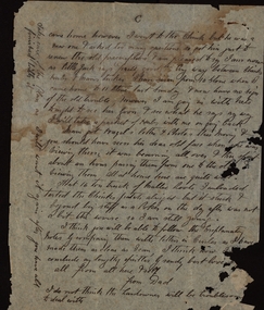 Federation University Historical Collection
Document - Correspondence, Richard Squire Mining Correspondence
Seems that Tom pays Ned's wages. Numerous bores were sunk , some were opened out and driven in the direction of the reef. Numerous Cross cuts were also made from the main tunnel.Unless otherwise stated the letters are from Dad (Richard Squire) to Tom, Hazel & Kiddies all. .1) Handwritten two page letter from Richard Squire to 'Tom & Hazel & little men' with information regarding the Leigh River Tunnel at Mount Mercer, dated 6/8/28. .2) Handwritten three page letter with information regarding mining operations dated 27.6.29. .3) Handwritten three page letter from Richard Squire to 'Tom & Hazel & Flock' with queries regarding the health of one of their children, other personal information and information regarding mining operations dated 18/7/29. .4) Handwritten one page letter from Richard Squire to 'Tom' dated 20/7/29, regarding the enclosed handwritten receipt with stamp for Call of two shares costing 8 pounds 7 shillings and 2 pence in Leigh River Tunnel Syndicate from Richard Squire dated 13th July 1927. .5) Handwritten two page letter from Richard Squire to 'Tom & Hazel & Pinchers' regarding his health, other personal information and information about the four page report of position of work at 'Leigh River Tunnel' enclosed. The letter is dated 29/11/29 and the report dated Nov 28th 29. .6) Handwritten two page letter with personal information and a suggestion that Tom learn to swim dated 13th Jan 30. .7) Handwritten two page report by Richard Squire regarding Leigh River Tunnel Syndicate plus a one page 'Rough Section' drawing of the tunnel dated 29th April 1930. .8) Typed one page report by Richard Squire regarding Leigh River Tunnel Syndicate and the findings of a new shaft dated 9th December 30. .9) Handwritten one page letter by Richard Squire to 'Tom' regarding mining operations and four handwritten receipts for payment of Calls from Richard Squire and Mr H McLeod and Mr E McLeod with stamps. .10) Handwritten two page letter regarding a meeting he had with the Secretary for Mines, Mr Whitehead dated 22 Feb 1931. .11) Handwritten two page letter regarding the difficulties in financing the mining operation occasioned by the interference of the government department dated 12th Mar 31. .12) Handwritten one page letter regarding the delay in the submission of his letter to the Gold Committee and with details of plans he had sent to Tom separately, dated 1st April 31. .13) Handwritten two page letter by Richard Squire to 'Tom' regarding personal matters including his health and also information regarding Tunnel work, dated May 11th 31. .14) Handwritten two page letter regarding the mine work, how his new employee, Ned, was going and also his health, dated Thur 21st May 31. .15) Handwritten two page letter regarding the Tunnel progress and financial matters dated Tue 26th May. .16) Handwritten three page letter regarding the Tunnel progress dated Thur June 11th. .17) Handwritten two page letter regarding the Tunnel progress, an issue relating to Ned's taxation assessment and his own health, dated 28th June 31. .18) Handwritten three page letter with detailed information on the Tunnel progress and information regarding his health, dated Thur July 23rd. .19) Handwritten two page letter regarding the Tunnel progress and some personal greetings, dated Thur July 30th 31. .20) Handwritten two page letter regarding the Tunnel progress, an agreement with Messrs Read & Peers? and a renaming of a Prospect as Lawaluk instead of Mount Mercer, dated Sun 2nd Aug 31. .21) Handwritten three page letter regarding the Tunnel progress, the lease agreement on Mr Read's property at Mount Mercer which he had been unable to pay and a parsley root remedy which a Ballarat Chinese herbalist had prescribed for his catarrh and had been effective, dated Thur 13th Aug 31. .22) Handwritten two page letter regarding the efficacy of the parsley (root) water in healing his catarrh and detailed progress report on the Tunnel which showed a little gold in the uncovered 'wash', dated Mon 24th Aug. .23) Handwritten three page letter regarding the progress of the Tunnel and one of the bores sunk also mentions his health, dated Mon Sept 7th. .24) Handwritten three page letter regarding the Tunnel progress in detail and an account of his illness, dated Thur 24th Sept. .25) Handwritten two page letter regarding the Tunnel progress in detail and his health which had been poor, dated Thur Oct 8th 31. .26) Handwritten four page letter regarding the Tunnel progress in detail, dated Thur Oct 22. .27) Handwritten four page letter regarding a detailed report of the Tunnel progress including the news of some show of gold and other personal matters including advising Tom not to drive there when he would have to drive home in the dark because of the accidents caused by 'Boosy Drivers', dated Thur Nov 19th 31. .28) Handwritten two page letter regarding the continued promising Tunnel progress, dated Thur Nov 26th. .29) Handwritten two page letter regarding Tunnel progress and personal matters relating to the coming Christmas visit, dated Thur Dec 3rd 1931. .30) Handwritten two page letter regarding Tunnel progress and personal matters regarding the impending visit by the family, dated Sun Dec 6th 31. .31) Handwritten two page letter regarding his health and the treatment proscribed by a Chinese herbalist and also some information about his expenses, dated Sunday 25/1/32. .32) Handwritten four page letter regarding Tunnel progress including a small diagram and further information on his health, dated Thur 25th Feb 32. .33) Handwritten three page letter regarding Tunnel progress and some personal and family information, dated Mon 21st 32. .34) Handwritten one page letter regarding some personal matters and information about the Tunnel progress, dated Thus 31st Mar. .35) Handwritten two page letter regarding detailed information about the Tunnel as well as a one page diagram of the Drives being excavated, dated Sun night 3rd April. .36). Handwritten three page letter from his home in Prahran regarding a mixture of personal matters and matters relating to the Tunnel, dated 18/4/32. .37) Handwritten one page letter regarding enclosed three shares which were to be placed as he was very short of funds, dated 19-4-32. .38) Handwritten two page letter from his home in Prahran regarding work carried out by Ned at the Tunnel and family matters, dated 6/5/32. .39) Handwritten one page letter from his home in Prahran regarding work carried out by Ned at the Tunnel, dated 10/5/32 plus an attached one page letter written by Ned (E. Woodlook) to 'Mr Squire' regarding regarding Tunnel progress, dated Saturday. .40) Handwritten two page letter from his home in Prahran regarding Tunnel progress and some personal matters, dated 27/5/32 plus an attached one page letter written by Ned to 'Mr Squire' regarding Tunnel progress and with the information that the rats were bad in Richard's hut, dated Friday. .41) Handwritten two page letter from his home in Prahran regarding Tunnel progress, dated 3/6/32 plus a two page letter written by E.Woodlock to 'Mr Squire' regarding Tunnel progress as well as person matters regarding his health, dated Friday (27th May 32 written in pencil by Richard). .42) Handwritten three page letter from his home in Prahran regarding tunnel progress and financial matters, also detailed information about the Madison's Tunnel, dated 8/6/32, plus a one page letter from E. Woodlock (Ned) to 'Mr Squire' regarding Tunnel progress dated Saturday (4 June, 32). .43) Handwritten three page letter from his home Prahran regarding a sketch he had made of Madison's Tunnel and the Mercer Shaft (not present) and the similarity of other mines with barely Payable gold, dated 13/6/32. plus a one page letter from E. Woodlock to 'Mr Squire' regarding Tunnel progress dated Saturday. .44) Handwritten one page letter by Richard Squire to 'Tom' from his home in Prahran with some personal information as well as the hope to return to Mt Mercer as he felt he was now well, not dated, plus a two page letter from E. Woodlock to 'Mr Squire' regarding duty stamps sent and Tunnel progress dated Saturday. .45) Handwritten two page letter from his home in Prahran regarding the progress of the Tunnel, dated 21/6/32, plus a one page letter from E. Woodlock regarding the progress of the Tunnel work, dated Monday (20/6/32). .46) Handwritten three page letter from his home in Prahran regarding the price of gold and the effect that mining Payable gold in the Madison Tunnel could have, dated 27/6/32. .47) Handwritten three page letter by Richard Squire to Tom, Hazel & Kiddies all' from his home in Prahran regarding his thoughts on the Madison Tunnel at Piggoreet, dated Mon 4th July 32, plus two one page letters by E Woodlock to 'Mr Squire' regarding the Tunnel work and more personal things, dated Wednesday (June 29th 32) and Saturday (July 2nd). .48) Handwritten two page letter from his home in Prahran regarding his intention to return to the diggings in a small car procured for his use and his intention to re-peg the Leigh River Lease in another name, dated Sun 17/7/32, plus a two page and a one page letter by E Woodlock to 'Mr Squire' regarding progress at the Tunnel dated Thursday (7th July) and Tuesday (12th July 32). .49) Handwritten one page letter by E Woodlock to Mr Squire detailing the tunnel work and other work related details dated Saturday (16th July 32), plus a one page letter by 'Dad' (Richard Squire) to 'Tom, Hazel & Kiddies all' regarding the letter sent by Ned (E Woodlock) and the ongoing work. He also talks about the health of Mam, his wife, dated 19th July 32. .50) Handwritten one page letter regarding the work at the tunnel and with the information that he was to finally return to the mine, dated 22/7/32, plus a one page letter by E Woodlock to Mr Squire about the ongoing work, dated Wednesday (20th July). .51) Handwritten two page letter written from Mt Mercer, regarding the works in the Mt Mercer Tunnel (mentioning South Cockloft). He also details that the drive from town (Melbourne) took 4 gallons of petrol, dated Thur 28th July 32. .52) Handwritten 3 page letter detailing the work carried on at the tunnels and with the information that underground gas had halted work temporarily. He was keen that Tom should visit one weekend soon, dated Sat 6th Aug 1932. .53) Handwritten four page letter detailing the work and new bore holes near Madisons Tunnel. The No 1 tunnel work had to be suspended due to continued gas filling the diggings every time the barometric pressure dropped. On the last page was a rough sketch of the area which was being worked, dated 19th Aug 32. .54) Handwritten two page letter regarding Tom's proposed visit to the site and some plans that he should bring with him. He also spoke of a pup that he was housing till Tom came, dated 21/8/32. .55) Handwritten one page letter encouraging Tom to bring skid chains for his vehicle as the road was muddy when he came on the weekend. He gave a brief account of the work and of the pup's progress, dated 25/8/32 .56) Handwritten three page letter regarding the weather and the relief he felt at knowing Tom and his companions had arrived safely home. He also thanked Tom for the cheques for Ned and detailed a little of the work at the tunnel and the need for more explosives as well as the fact that they had had to put a lock on the door of the hut to stop intruders, dated Sun Sept 4th 32. .57) Handwritten one page letter regarding the ongoing work at the tunnel, dated Thur Sept 8/32. .58) Handwritten two page letter written from Prahran, regarding his trip home, work at the tunnel and with information about the enclosed receipts, dated 16/9/32. Also included was a one page letter from E Woodlock to Mr Squire regarding the work at the tunnel, dated Wednesday. .59) Handwritten one page letter from Dad (Richard Squire) to 'Tom, Hazel & Kiddies all' written from Mt Mercer, regarding the work at the tunnel and the effect that 2 inches of rain had on the work, dated Wed Sept 20th 32. .60) Handwritten two page letter regarding the work at the tunnel and with the information that Mr Read who owned the property where the tunnel was located, had a serious accident in Melbourne, dated Thur 29th Sept 30 (this 1930 date is a mistake as the information contained in this letter follows on from his previous letter dated 20th Sept 32). .61) Handwritten one page letter regarding the work at the tunnel with the encouraging information that flecks of gold were found in about half a dish (mining pan), dated Thur Sept 22nd. .62) Handwritten two page letter regarding the progress at the tunnel and the difficulties of the work and thanks for Ned's cheque. Also mentioned was the information that Mr Read had a fractured pelvis and would be in hospital for two months, so Mrs Read with her father was looking after the shearing, dated Thur 6th Oct. .63) Handwritten two page letter with a third page of a diagram of a cross section of the Leigh River Tunnel, including the new tunnel and Madisons tunnel, with detailed description of the work in the tunnel, dated Sat 8th Oct. .64) Handwritten two page letter written from Prahran, giving detailed information of the tunnel and the expected outcome of the work. He also commented that he was to visit Mr Read in hospital, dated 14/10/32. .65) Handwritten two page letter written from Mt Mercer, giving information about the work in the tunnel and his visit to Mr Read, dated Wed 19th Oct. Enclosed also was a one page letter from E Woodlock to Mr Squire giving an account of his work in the tunnel, dated Thursday. .66) Handwritten one page letter regarding the work in the tunnel, dated Sun Oct 23/32. .67) Handwritten two page letter from Dad & Jim (Richard Squire) to 'Tom, Hazel & Kiddies all' regarding the receipt of Ned's wages cheque and the insurance of Ned's person as well as a detailed description of the tunnel and its relationship to Madisons Tunnel. He also gives some indication of his health, dated Tue Nov 1st 32. .68) Handwritten on page letter written from Prahran, giving a small amount of information about the tunnel work as well as his visit to see Mr Read and some personal information, undated. Enclosed also is a one page letter by E Woodlock to Mr Squire about the work in the tunnel, dated Thursday. .69) Handwritten one page letter with little information, dated 11/11/32. Also enclosed is a one page letter from E Woodlock to Mr Squire about the work in the tunnel, dated Thursday. .70) Handwritten three page letter with detailed information about the tunnel work and an aside about Jim's help and the he suffered from "Imaginitis imagines he sees a speck of gold in every bit of gravel met", dated 10/11/32. .71) Handwritten two page letter with detailed information on the work as their tunnel crossed with the old Madison Tunnel, dated Thur 17th Nov. .72) Handwritten three page letter detailing information on an application for a 500 acre lease which was posted at the Grenville Post Office and how it would impact on their lease. The upshot was that their leases would need to be re-pegged and the fee to publish a Notice of Application on their Leigh River claim was necessary to pay and he wondered if one of their investors would pay the 10 pounds necessary to secure the claim. He also spoke of perhaps forming a Company to put a plant on their Mt Mercer shaft as he felt that the gold would be of a payable quantity, dated Sunday 20th Nov, Also included was a note written by Ned (Edward Woodlock) who had copied the Notice of Application. .73) Handwritten two page letter detailing information found in Madison's Tunnel as it related to their own tunnels, particularly No 2 tunnel and how far he felt he would need to tunnel to reach an improvement in the 'wash', dated Thur 24th Nov. .74) Handwritten one page letter thanking him for the cheque the investor, Mr Wilkinson had provided for the Notice of Application for the Mt Mercer old Lease of 828 acres. He also gave some information about how it was originally farm labourers who only worked this lease and only when they had no other work. He also gave some personal information about Mam's birthday, dated Mon Nov 28th 32. .75) Handwritten two page letter by Dad (Richard Squire) to 'Tom, Hazel & Kiddies 3' written from Prahran, telling them that they had received Ned Cheque and that that Jim and He had come home. He also detailed an incident that Jim had had with a tyre blowout whilst on his way to get explosives and post the Notice of Application in the Warden's Office in Ballarat. The stub axle had bent and Jim had to ride a bike to get a new one and after changing the inner tube of the tyre they were able to drive back to Melbourne and were in the process on having the tyre re-treaded, dated 6/12/32. .76) Handwritten one page letter explaining how he and Mam had contracted colds and that his kidneys had some of their of trouble. He hoped to return to Mt Mercer on the weekend, dated 18th Jan 33. Also included was a handwritten two page letter by E Woodlock to Mr Squire giving information about the tunnel work, an injury to his hand and the fact that he had only 3 picks that were any good. He also asked for some vegetables, tomatoes and bacon when Richard returned, dated Saturday. .77) Handwritten one page letter written from Mt Mercer, giving information about the tunnel work, now 97'6" in and how he had expected to have already come upon the Madison's gold bearing gravel wash, dated Wed 25th Jan 33. .78) Handwritten two page letter with detailed information about how the tunnel had cut across a second Madison's tunnel and the prospects in this tunnel looked more promising. He also stated that he had not been well the last few days, dated Frid 27th 33 .79) Handwritten one page letter with information about the shotty gold found and the tunnel work and that he would test the value of the wash where the gold was found, dated Mon 30th Jan. .80) Handwritten short note of one page giving sketchy information about the tunnel work, dated Tue 31st Jan 33. .81) Handwritten two page letter giving information about his dealings with the Secretary for Mines relating to the fact that because the application for lease was identical to the old lease, they therefore should not need to pay for a full survey costing 7 pounds, just an inspection. He also detailed the workings and asks for more parsley roots to be sent to him, dated Thur Feb 9th 33. .82) Handwritten one page letter stating that he had received Ned's cheque and information about the workings, the coarse gold found and the fact they were going home for fresh food, dated Tue 14th 33. .83) Handwritten two page letter giving detailed information on the progress of the tunnelling as well as the information that Len and Max had come to visit the site and that Len had brought with him Keating, who he detested and pondered the reason for his bringing the man. As they were leaving Max "told Ned he thought they were going down to Ice Mam". Richard was worried about paying the 7 pounds ten shillings for the Department of Mines survey and was loath to put in another 20 pounds for another share of the mine to pay for it. He gave his thanks for a parcel of parsley he'd received , dated Tue 21st Feb 33. .84) Handwritten two page letter written saying that he had received Ned's cheque (for wages) and giving detailed information on the progress and for the need to timber the drive and have the bottom stoped up. He had no timber or laths left and was concerned about the cost necessary to satisfy the Mines Department. He mentions the possibility of insolvency. Fine gold had been found but not like the Madison's tunnel, dated Tue 28th Feb 33. .85) Handwritten two page letter written giving detailed information of the progress in the tunnel and with the expectation that they would soon meet the same wash which was in Madison's Tunnel. He also personal information about his health. the parsley roots received and the apples which Jim had "burgled", dated Sun 5th Mar 33. .86) Handwritten four page letter by with a very detailed account of the progress of the tunnelling and the reason why the expected intersection with the Madison wash did not occur, but with the hope that this intersection would soon occur, then they would be able to meet expenses. He also talked about not being able to pay for the lease but had the hope they they would not be too rigid in their case. He added some personal information about Jim not having the makings of a miner, catching rabbits "for the pot" and the fact that Mr Read was so much better that he was able to ride his horse, dated Sat 11th Mar 33. .87) Handwritten one page letter written from Prahran, acknowledging the receipt of Ned's cheque, a note about the work at the tunnel and some personal information, dated 21/3/33. .88) Handwritten one page letter written from Mt Mercer, saying that there was little change in the tunnel but that he was would open a cross cut north, dated Thur 23 March 33. .89) Handwritten note of a half page telling them that he had cross cut the tunnel, dated Sat 25th Mar. .90) Handwritten one page letter with progress of the tunnelling and where it is in relation to Madison's Tunnel, dated Thur 30th Mar 33. .91) Handwritten three page letter with the first part of the letter talking about the personal and financial worries he and his family had with travelling and mining expenses as well as Ned's wages which could not have been managed without Judy's little car, Jim's help and the payment of Ned's wages by Tom. He went on to give detailed information of the tunnelling and then talked about a letter received by the Department of Mines regarding the non payment of the lease and that a Notice of Abandonment would be published if not paid. Lastly he talked about the struggle he had had with this process and that it was only because of Tom's help that he had been able to continue this far, dated Sun 2/4/33. .92) A one page letter with information about the progress as well as the information that he had not heard from the Mines Department regarding the lease, and the the 1000 sq ft Miners Right Claim was secure, dated Thur 6th April. .93) A three page letter with detailed information about the work in the tunnel and also detailed explanation of the leases he has pegged and repegged. He also thanked Tom for paying the balance which was owed to the Department and informed Tom that he was going home, dated Tues 11th April 33. .94) A four page letter written from Prahran, thanking Tom for Ned's cheque and with information about the work still being carried on by Ned. He also talked about the pegging of the Mt Mercer claim and the cost of the advertisement and application and survey fees to secure the site as well as his opinion of the probable value of the gold from this site. He also stated that he really needed more investment from those who had initially invested with him or from new investors, dated 17/4/33. Included was a one page letter from Edward Woodlock (Ned) to Mr Squire regarding the work he was carrying out at the tunnel, dated Saturday. .95) A three page letterwritten from Mt Mercer, regarding the work in the tunnel and the quality of the gold found and the direction they will take. He also stated that he was posting letters to the original investors to see if they would contribute to the cost of the lease and also talked about another man who had a Notice of Application posted at Grenville for the water rights for a 25 miles long area and a dam. His Capital is 300 pounds and the supposition is that he wants to 'unwater' the leads, dated Frid 20th April. .96) A one page letter regarding the continued work in the tunnel and how his suppositions seemed to be correct, dated Thur 27th April 33. .97) A three page letter thanking Tom for Ned's cheque of 6 pounds 7 shillings and 6 pence. He also gave detailed information about the tunneling and the type of ground found and his next intentions. He also gave further information about the Notice of Application at Grenville which was posted by B Ryan, Agent for Western Deep Leads Coy Limited for 6000 acres, dated Sun 30th April 33. As well is a note detailing the information copied from the Notice. .98) A two page handwritten letter detailing the work being carried out as well as a complaint that he had not heard from the men he had written to, dated Thur 4th May 33. .99) A one page handwritten letter regarding the tunnel work and informing Tom that the gold found is shotty, dated Sat 6th May 33. .100) A four page handwritten letter written from Prahran, detailing the tunnel work and informing that the gold prospects were better in no.1 cross cut south and there was also payable fair gold where they were currently working, if worked in bulk. He also talked about the possibility of new investors as the old ones had not responded to his letter and the necessity of securing the leases, dated 11th May 1933. .101) A one page handwritten letter by E. Woodlock (Ned) to Mr Squire regarding the work going on, dated Thursday. .102) A six page handwritten letter written from Prahran historically detailing the acquisition of the two leases at Mt Mercer, 35 years earlier, with M C Donnely/Donney and Jas Clements, including Madisons. He goes on to clarify Tom's suggestion regarding the Leases and the Companies to be floated, then details the the shafts, bores, tunnels and Deep Leads held in the leases and then goes on to say what his next steps would be, dated 13th May 33. .103) A two page letter written from Mt Mercer detailing the continued work in the tunnel with the added information that because of the incline it was taking two men to push the truck up the tunnel. Richard also told of the need to take more parsley water for his condition, dated Thur 18th 33. .104) A three page letter with a very detailed description of the work in the tunnel. Richard also told that he had run out of metal rails and was having to use timber as a substitute. He was also to re-peg the North and South Leases in the morning, dated Sun 21st May 33. .105) A two page letter detailing the work in the tunnel and saying that there was a hundred feet of rail locked in by a fall in the No.2 Tunnel and he was hoping to get them out to replace the wooden rails as they made for heavy work on the inclines. He also said that he had a letter from the Department telling him to communicate with the Surveyor in Ballarat, dated Wed 24th May. .106) A three page letter acknowledging Ned's cheque as well as information about the work in the tunnel, including that he had been able to retrieve 45 feet of rail and would get more when needed. He said he was pleased that Tom and Mr Wilkinson were making a trip on Saturday to see him. He talked of the weather and the fact that the bread was a week old, so to bring enough to last till the Monday. Among other things he also spoke of Tom revising the Plans and also having a Share book printed and the name was to be the Ballarat Deep Leads Extension for which there could possibly be 3 Companies, dated Sun 28th May. .107) A one page letter with information about the work in the tunnel and also a weather update and the best way to come, dated Wed 31 May 33. .108) A two page letter written from Prahran, explaining a visit to the Leigh River Shaft to get whim rope, whip wheels and sundry items. He shifted some equipment and built a new forge and was to fix and mount a windlass and rope to enable Ned to get the truck up the incline of the tunnel. He also spoke of the work being undertake by Ned then when on to more personal correspondence about a birthday present for one of Tom's boys, dated 9/6/33. .109) A two page letter acknowledging receipt of the 'Prospectus of the Ballarat Deep Leads Extension Syndicate' and 'Share Certificate'. The No.1 Lease was in Ned's name and the No.2 Lease was in Jim's name to avoid inquisitive interest. Jim logged a Notice of Application and paid the fees. Richard acknowledged receipt of Ned's cheque and asked for 5 pounds as his finances were 'rather tight', dated 14/6/33. Included was a 1 page letter from Ned to Mr Squire regarding the work in the mine, dated Saturday. .110) A one page letter written from Mt Mercer giving information about what was happening in the new x cut N near the mouth of the tunnel, dated Friday 16/6/33. .111) A one page letter telling about the work and that he had fixed an old shed of Mr Reads for the forge. Mr Read and Mr Cameron visited and Richard was hopeful that Mr Cameron, the owner of the land in the North Lease would be easy as regards an agreement, dated June 22/33. .112) A two page letter which talked about his health, the mine, the local J.P. who had lost his eye in a shearing accident and the surveyors visit, He also spoke about contacting the Gold Mines Ltd and the Berry Leads Company, dated Tue 27th 33. Also included was a letter to the Mines Department and a receipt from the Mines Department for the sum of 7 pounds 10 shillings as well as the Lease Applications from the newspaper dated June 13th 1933. .113) A two page letter complaining of the charge made by the Mines Department for a Surveyors Inspection. He also wrote of trying to set up a float for the mine which he would do when he returned home.He also explained the current findings at the mine, dated Sun 2nd July 1933. .114) A one page note written from Prahran informing Tom that he had not yet heard from Gold Mines Ltd and also that there was a hitch with the lease on the house, but this was to hopefully be fixed the following day. He also spoke of Tom's trip home (completed in tow), dated 18/7/33. .115) A two page letter recounting some of the difficulties they were having with the new owners of the house they leased in Prahran. He also spoke of the fact that the Mines Department had requested another 10 pounds although they had not yet completed the survey on either mine, dated 21/7/1933. Also included was a one page letter from E. Woodlock (Ned) to Mr Squire about the workings, dated Tuesday and a letter from the Gold Mines of Australia Limited saying that the information he had supplied was now with their engineers, dated 20th July, 1933. .116) A three page letter written from Armidale saying that Mam (his wife) was fretting with the move to this house. He also told of the rejection by the Gold Mines of Australia Limited of his proposal to invest in his Mt Merser Mine, stating that he believed that Jim Clements who had been the manager when the mine had previously been opened, had most likely "thrown all the cold water he could" on the proposal. He spoke at length about how this man had run the mine into the ground and his own involvement with the winding up of the company. He went on to say that he would approach Ryall to see if he was interested in investing, dated 28/7/33. Included was the letter from Gold Mines of Australia Limited, dated 26th July, 1933. .117) A two page letter written from Prahran telling of the move to another house where Mam was quite settled. He also wrote of the work Ned was carrying out at the mine as well as personal and family news. He wrote that as he had not heard from Ryall, he would visit him the following day, dated 6/8/33. Also included was a two page letter from E Woodlock to Mr Squire giving detailed information of the progress at the tunnel, as well as asking for a new pair of boots as the ground was so wet his were letting in the water, dated Thursday. .118) A two page letter explaining about a letter he received from Mr Cameron who believed he had found gold as well as some personal information and his health, dated 8/8/33. Also included was a one page letter from Neil W Cameron to R B Squire telling about some specks of gold he'd found in a post hole, dated July 31st 33. Thirdly was a one page letter from Ned to Mr Squire explaining the work he was doing in the tunnel, dated Saturday. .119) A one page note saying that he did not like the enclosed 2 copies of the typed Agreement of the Leigh River Gold Mining Company with William Ryall, but asked Tom's advice. dated 9/8/33. .120) A two page letter dealing mainly about the work going on at the new house and the settling in process. He also wrote about the proposed Agreement with Ryall, dated 11/8/33. Also included was a one page letter from Mr Ryall to R B Squire from which part of the left hand side had been severed, dated 10th August 1933. .121) A one page note from R B Squire to W Ryall dated 14/8/33, with attached one page of information and figures. Also attached a one page letter from R B Squire to W Ryall asking if Ryall would be interested viewing the plans for an alluvial mining proposition, dated 27/7/33. .122) A three page letter mainly about the visit to Ryall and a Mr Cundy about the proposed agreement with his concerns about the language and terms of the agreement, dated Sun 21st 33. Also included was a letter from Ned to Mr Squire about the continued work in the tunnel and the fact that two of the pick heads had cracked and would have to be fixed, dated Thursday. .123) A two page letter dealing with a meeting had with Ryall and others in a private office regarding the interest in investing in the mining proposition, dated 23/8/33. .124) A four page letter dealing mainly with the work at the tunnel and exploratory diggings at the spot Mr Cameron had written about as well as the damage done to the car on the way to the workings, dated 29/8/33. .125) A one page letter telling of a proposed meeting with Mr Taylor and a Mr Bowler, who may turn out to be Alan Bowler who he knew, regarding the Mr Mercer Float scheduled for the following day, dated 30/8/33. .126) A five page letter explaining the content of the meeting held with Mr Bowler, who represented an English consortium which was interested in the Mt Mercer site. He explained the terms that the consortium would offer if they went ahead, This included 25 % shares in the mine but no money, which he bemoaned because of the shortness of their cash reserves. He went on to detail the 4 distinct deposits of wash in this field, which he believed were unique in the Ballarat district. He also stated that he had not heard from Mr Ryall. He closed by talking about the water levels in the mine, dated 1/9/33. .127) A two page letter saying that he had written an 11 page report on the Mt Mercer field for the English consortium as well as a private letter for the chairman.He also reported that he had been to see Ryall. Neither party knew that he was talking to the other. added was some personal information, dated 6/9/33. .128) A one page letter telling of a meeting with Mr Bowler and Mr Tayler who carefully went through his report. It was then being typed. He believed he had two strong supporters, dated 7/9/33. Also included was a 2 page note from A Bowler to R B Squire asking him to bring the report into the office the following day to be perused and typed, dated Sept 6th 33. .129) A two page letter with personal encouragement for one of the children. The letter then goes on with more information about the meeting with Mr Tayler and Bowler and his impressions of their interest. He also talked about the one of the experts who was to examine the site and also about the report which was now typed and a copy sent to Tom, dated 8/9/33. .130) A one page letter keeping him informed of progress. The expert was away but would be briefed on his return. He also thanked Tom for a cheque, which was used to get the car 'Liz' back in order for the trip to be made with the experts at a later date. He informed Tom of his intention to return to Mt Mercer, dated 13/9/33. .131) A one page letter written from Mt Mercer telling of the trip from Melbourne and the weather. He spoke of what was happening in the tunnel and that he had not yet heard from any of the interested parties, dated Tue 19th Sept. .132) A five page letter written from Prahran with detailed information about the tunnels, the washes and the shows. He also detailed his meeting with Bryant 38 years ago at the No 1 at Carisbrook and how he had given him assistance at that time and subsequently as well as giving his version of a potted history of Bryant, dated 29/9/33. .133) A two page letter with information about the arrival of the chairman of the English group and that Ned had shown Mr Kermode around the site, dated 6/10/33. Also included was a cutting from the Age about the arrival of Mr F W Baker, representing a large English financial group interested in Victorian deep lead propositions, dated Oct 6th. As well were two, one page letters from Ned (E Woodlock) to Tom, regarding the work in the tunnels, the bad air and the hopes of a successful float, dated Tuesday and Wednesday. .134) A one page letter thanking them for the gift of eggs and parsley. He also talked about a letter from Bowler regarding the business of the experts and that their leases would be seen in due course, dated 10/10/33. Included was a one page letter from A Bowler to P B Squires saying that Mt Mercer site was receiving attention but that no decision had as yet been made, dated Oct 9th 1933. .135) A three page letter written from Prahran giving information about Richards visit and conversation with Mr Ryall, who indicated that no decision had as yet been made regarding his proposal. He also included some personal information about members of the family, dated 18/10/33. Included was a one page letter from Ned (E Woodlock) to Tom with information about the tunnelling progress in no.2 tunnel and the bad air that drove them out for a time, dated Saturday. .136) A one page letter containing a brief update on the state of affairs , dated 20/10/33. Included was a one page letter from Ned to Mr Squire with an information on the progress at the tunnel and with the information that his hands were cracked so badly that he was wearing two socks on each hand, dated Saturday. .137) A one page letter which family news and a paragraph about the figures in his calculations, dated 21/10/33. On the back side was a letter from E Squire (his wife) to Tom, Hazel & boys again with family and personal information, dated 22nd 10/33. .138) A three page letter with the disappointing news that the English consortium would not take up the option on the Mt Mercer lease and gave his opinion that it was self interest that stopped it going ahead. He then gave two options as to the way forward, dated 24/10/33. Also included was a typed one page letter from W C Tayler to R B Squire informing him of a letter stating that the proposal had been turned down, dated 23rd October 1933. .139) A three page letter informing of further developments with Mr Tayler who asked for the plans to be left at the office till the following week as there was another company who may yet be interested to take up the option, dated 27/10/33. .140) A one page letter asking for 9 copies of the old agreement to be typed for the 3 Syndicate members, Rice, Cameron and McNaughton, dated 5/11/33. .141) A three page letter regarding the decision by the Syndicate to reopen the LRG shaft and the practical issues of timber acquisition and probable costs. He then went on to talk about Mam's indisposition and treatment by the herbalist, Goon, dated 8/11/33. Also included was a newspaper clipping from the Age entitled 'Inquiries for properties at Ballarat'. .142) A three page letter giving all the news regarding the agreements, the costs and the way forward. He also spoke of his wife's improvement and other personal information, dated 11/11/33. .143) A two page letter written from Mt Mercer regarding the difficulties in obtaining the timbers and tanks needed to reopen the shaft and the state of all the existing fittings and what would be needed to get the site operational again. His agreement with Mr Read had duly been signed, dated Thurs 16th 33. .144) A two page letter with further information about the progress with acquiring and repairing the shaft site, dated Mon Nov 20th 33. .145) A three page letter informing that the timber for the whim & shaft were being delivered and the area had been cleared out for the poppet heads. The top of the shaft had been cleared ready for re-framing and other work had been carried out. Liz, the car had broken down and Jim was in the process of fixing her. He concluded with information about his and his wife's health, dated Sun 26th Nov 33. .146) A four page letter with news of Mam's health, the problems associated with fixing the car and the floods which stopped Jim from going to Ballarat and washed away the Gary Bridge which affected the mail and had halted work at the shaft, as well as delaying the second delivery of timber, dated Sun Dec 3rd. .147) richard squire, william ryall, jim clements, gold mines of australia limited, e woodlock, ned woodlock, neil w cameron, alan bowler, mr cundy, don mcnaughton, mr rice -
 Ballan Shire Historical Society
Map - Map. Bungal, Department of Lands and Survey, Bungal, County of Grant, 09/09/1926
A map of Bungal in the 1920's showing the allotments, and the size, with the names of the residents. It shows the roads and the Western and Eastern Moorarbool River, and the Whipstick State Forest.Cream coloured map of Bungal in the County of Grant, bounded by the the East Moorarbool River on the East, and the State Forest on the South. It is marked with the scale of chains and the number L.358. Lithographed at the Department of Lands and Survey. Melbourne by W. J. Butson on 9.9.1926. It shows the land allotments with names of owners.Coloured pen marks and circled numbers on various areas. Price 2 shillings marked on bottom right hand edge.bungal, kerrit bareet, egerton, lal lal, borhoneyghurk, bungeeltap, ballark, yaloak, gorong, moorarbool west -
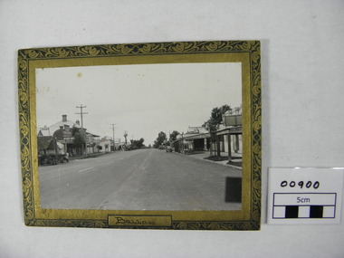 Ballan Shire Historical Society
Photograph - Photograph. Inglis St. Ballan, Inglis Street in Ballan, c 1930/40
Inglis Street of Ballan .circa 1930/40.The photograph is looking East. Parts of the Mechanics Institute and Free Library can be seen, as can the butcher shop, and on the opposite side of the Street the Ballan Hotel and Post and Telegraph office.Black and white photograph of Inglis Street Ballan.Looking East. Photograph is on a cardboard backing with an ornate surround of green and gold. Cars and a truck circa 1930/40 are parked in the street.The word Ballan written on bottom of surround under the photographtelegraph office, car, mechanic institute, butcher shop, delivery truck, 1930 40 cars -
 Ballan Shire Historical Society
DVD. Gordon P/S, Gordon Primary School Celebrates 125th Anniversary 2007, 2007
This DVD was produced to celebrate the 125th Anniversary of the Gordon Primary School in 2007. It is a pictorial history covering that period consisting of still photographs in a slide show format.DVD in a plastic case with a custom printed cover insert depicting a photograph of Gordon Primary School Class of 1882. Contains still photographs of staff, students, school grounds, functions, etc. over the last 125 years. A pictorial history set out in five (slide show) chapters with a sound track to accompany. DVD compiled and designed by Diane Lawson 2007. All proceeds from the sale of this DVD will be donated to the Gordon Primary School.school, gordon, primary school, 125th anniversary -
 Ballan Shire Historical Society
Map - Map. Ballark, Department of Lands and Survey, Ballark. County of Grant, 31/08/1915
A map of the Ballark area within the County of Grant showing roads, waterways, property boundaries and property owners in 1915.Significant to people researching land usage and ownership. Also those researching families in the area at that time.A map of Ballark in the County of Grant. Black printing on buff coloured paper. Extra notations by hand and various coloured highlighting of certain features. Details roads, rivers, property boundaries and names of property owners and districts. The map is easily readable although there is some physical damage to the borders and some sellotape residue. Shows a scale in Chains and the number L.6030Various numbers and directional arrows added to map.bungal, borhoneyghurk, bungeeltap, ballark, beremboke, moreep, meredith, morrisons, moorarbool river -
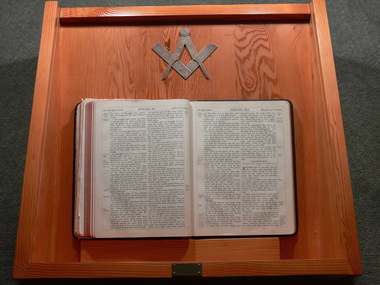 Ballan Shire Historical Society
Book - Book. Masonic Bible, Oxford University Press Warehouse, Holy Bible, 1900
This volume of the Sacred Law was presented to the Ballan Shire Historical Society on the 30th September 2009, following the closure of the Ballan Masonic Lodge No. 205 on the 9th February 2009. The Bible is assumed to have served the Lodge from it's Consecration on the 15th February 1908 until the Lodge closed. It was presented to the Society in a timber display case with a glass cover containing as well the Masonic Compass and Square and a plaque reading "Donated by Ballan Lodge No. 205 on the Return of the Warrant, February 2009". The display case measures 60.5cm wide, 59cm deep and 19.5cm high.A black leather covered copy of the King James version of the Holy Bible, holy bible, masonic lodge -
 Ballan Shire Historical Society
Map - Map. Kerrit Bareet, Department of Lands and Survey, Kerrit Bareet. County of Grant, 08/1944
A map of the Kerrit Bareet area within the County of Grant showing properties and names of owners in 1944.Significant to people researching land usage and ownership. Also those researching families in the area at that time.A map of Kerrit Bareet in the County of Grant. Black printing on buff coloured paper. Details roads, rivers, railways, property boundaries and names of property owners and towns and villages. The map is easily readable although there is some physical damage and that and the borders have been reinforced with sellotape. Shows a Scale in Chains and Price 2/.gordon, bungal, kerrit bareet, lal lal, moorarbool river, warrenheip, bungaree, wallace, moorarbool west -
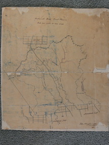 Ballan Shire Historical Society
Map - Map. Bullarook State Forest, Bullarook State Forest Reserve
A small map of the Bullarook State Forest Reserve. Drawn on a fine buff coloured paper attached to a stiff cloth backing sheet. The title is hand written and includes a "scale one mile to one inch" hand written also. The map is signed "John Wrigglesworth, assistant ? and dated 26/6/1869" although the month and year are almost illegible.moorabool west, state forest, bullarook, eastern moorabool river, werribee river, moorabool east, blakes saw mill, wombat, andersons saw mill -
 Ballan Shire Historical Society
Book - Book. St. Brigid's School, Ballan, St Brigid's School Ballan. A Short History, 2010
A short history of St. Brigid's (Catholic) School from it's beginnings as the Ballan Catholic Common School No. 100 at St. Agnes Church c. 1859 up to the present in 2010. The book contains teacher and class photographs, information on the establishment of Catholic Schools in Victoria, and a section on the history of Catholics in Ballan and the beginnings of the Church community. Recent events are covered as are recollections and interviews with former pupils.Significant to past and present students and staff, also to those researching family history and education within the local area.A small paperback book with an olive green cover on which is centered an oval coloured photograph of the school. 62 pages.schools, ballan, st brigids, catholic schools -
 Ballan Shire Historical Society
Book - Book. Address to King Edward VII, McCarron Bird and Co, Address to His Majesty King Edward VII. from the Municipalities of Victoria 1901, 1901
The book contains the Joint Address to His Most Gracious Majesty King Edward the Seventh from the Municipalities of Victoria, and is dated Melbourne, 30th January 1901. It contains the Cities, Towns, Boroughs, and Shires with the signatures of the chief officers of each and signatures of the Executive and Executive Committee of the Municipal Association of Victoria.A thin hard cover book with a royal blue cover and gold leaf title title with an upright leaf embellishment on the left. Book No.108. 16 pages.With the compliments of the Executive Committee of the Municipal Association of Victoria.king edward v11, municipal association of victoria, royal visit 1901 -
 Ballan Shire Historical Society
Book - Book. The Walsh Papers, The Walsh Papers, 1985
The former Shire of Ballan commissioned this work which ties in with the formation and early years of the Ballan Shire Historical Society. It is a collection of articles, works and memoirs written and compiled by James Henry Walsh, an early resident of Ballan, that have been edited for publication by James Turner. The book contains maps and photographs and is fully indexed. It is considered by some to be the foremost reference work on the history of Ballan.The book is significant as it is a comprehensive collection covering the history of Ballan. It is a limited edition and now out of print.A soft covered book, ivory in colour. Printed on the cover is - "The Walsh Papers. Edited: J.L.Turner. Memoirs of the early settlement of Western Victoria and, in particular, Ballan Shire: 1830 -1875. Written and compiled by James Henry Walsh (1863 -1930) of Ballan." The back cover is a full page sepia photograph of James Walsh (head and shoulders only) and the printed number "ISBN 0 95599911 1 5". Book No.106. 312 pages.The book bears the stamp of the Ballan Shire Historical Society and the handwritten marking "Receipt P.1." Book No.106 and Reg No. (VC) 00909 in pencil.walsh james henry, ballan memoirs, turner j l, ballan history -
 Ballan Shire Historical Society
Book - Book. St John's Anglican Church, Ballan, St. John's Anglican Church Ballan. Index to Register of Baptisms 1849 -1991, 1991
The book is a collection of index cards transcribed from the Register of Baptisms from 1849 to 1991 at the St. John's Anglican Church in Ballan. These cards were then photocopied ten to a page and assembled and bound into this book. The book contains Volume 1 A -K and Volume 2 L -Z and the wording on the Title Page "This is a copy of the transcription, which was completed by Roy Huggins and a team of volunteers at Ballan. Acknowledgment is given to The Rector without whose permission the project could not have been completed. March 1991."The book is significant in that it contains a complete register of Baptisms conducted at the Church from 1849 to 1991 in alphabetical order. This is of significance to family researchers and makes a search of the records much easier.An A4 size book which is a collection of loose pages stapled, with cardboard covers and a brown tape spine binding. About 250 pages of transcribed, photocopied index cards. Book No.105.Pencil markings - Book No.105. Reg No. VBSH 01098ballan, baptism records, anglican church, st johns anglican church -
 Ballan Shire Historical Society
Certificate - Certificate. RVIB
A Centenary Certificate of Appreciation presented by the RVIB to the Ballan Auxiliary for outstanding service.A Centenary Certificate of Appreciation presented to Ballan Auxiliary for outstanding service. Royal Victorian Institute for the Blind, babies, children and adults. It bears the RVIB Seal, a logo and the words Centenary Year 100 1866/1966. It is signed by the President and the Executive Director. The certificate is cream coloured with a light blue border, under glass in a plain, beveled, light coloured timber frame.This registration number is marked on the back of the frame.certificate, royal victorian institute for the blind, ballan auxiliary -
 Ballan Shire Historical Society
Plaque - Plaque. Centenary of Government and Gold discovery, 1951
The item is a Plaque struck in 1951 to celebrate the Centenary of Government in Victoria and the Centenary of the discovery of gold.A round bronze medallion set in a green baize lift out in a black presentation case. It is a 1951 Commemorative Plaque to mark the Centenary of Government in Victoria and Centenary of the Discovery of Gold. There is a printed insert card describing the obverse and reverse sides of the Medallion."Presented to the Shire of Ballan 1951" is engraved on the reverse side. "1851" and "1951" are marked on the lining of the cover of the box.medallion, plaque, shire of ballan, centenary of government -
 Ballan Shire Historical Society
Photograph - Photograph. L A Fairbairn, Lachlan Alexander Fairbairn, 1916
There is not much information on this item at the moment. The record will be updated when more becomes available.A small black and white photograph of L.A. Fairbairn sitting in a wicker chair outdoors. The photograph is under glass in a small timber frame with scrolled upper edges.Labels stuck on the glass read - " the founder of L.A. Fairbairn 7 Co. St. James Bldg Melbourne" and "Lachlan Alexander Fairbairn - Ardoch tower-Essendon (1916)". A sticker, D4, is on the back of the frame.fairbairn lachlan alexander, l a fairbairn co