Showing 11380 items matching "centre road"
-
 Mortlake and District Historical Society
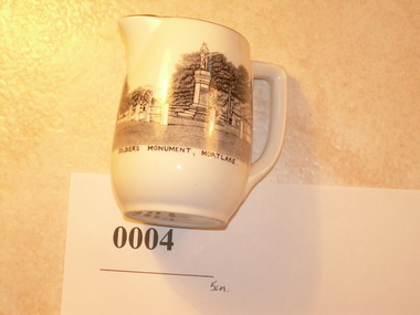
Jug, Melba Bone China, Probably 1950's, 1960's
This small white jug was probably created as a souvenir of Mortlake. Its depiction of the 'Soldier's Monument' (War Memorial completed 1920), is quite accurate and perhaps reflects the importance of such monuments in small country towns. Memorials created in many country towns, cities and suburbs after the Great War, reflected civic pride and were created in recognition of the sacrifice of so many men in defence of the realm. Mortlake's 'Soldier's Memorial' is typical of many such memorials Australia wide. It forms one part of the Mortlake's tribute, the others being the Soldiers' Memorial Hall (which incorporates the old Mechanics' Institute) and the Avenue of Honour (cypress) along the Hamilton Highway on the eastern side of the town. Small glazed white jug, with gold rim, handle; transfer picture of the Mortlake War Memorial - showing plinth, column, soldier and fence with backdrop of mature trees. Captioned: 'Soldier's Monument Mortlake'. On base: 'Melba Bone China (followed by crown insignia) Guaranteed Made In England.'1914, 1918, world, war, memorial, memorials, mortlake, souvenirs -
![Sign, [14/8/1937]](/media/collectors/4f729f5b97f83e0308601618/items/4f72acc197f83e030860399a/item-media/4f72acc197f83e030860399c/item-fit-380x285.jpg) Mortlake and District Historical Society
Mortlake and District Historical SocietySign, [14/8/1937]
Outbreaks of poliomyelitis were common up until the 1950's when vaccine became available. The cause was not known and management was difficult - paralysis in varying degrees was the usual outcome. Public concern was high especially concerning children. One of the most significant Australians to suffer from this disease, was Alan Marshall (1902 -1984) who was born in Noorat, 15 kilometres from Mortlake. He wrote an account of his boyhood after he was struck down by the disease, in the internationally acclaimed 'I can jump puddles' (1955).Rectangular piece of calico'Shire of Mortlake. INFANTILE PARALYSIS. 1. Parents or Guardians of all children aged eighteen and under coming into the Shire of Mortlake from the Metropolitan or any other area affected with Infantile Paralysis, MUST REGISTER such children immediately either personally or by post at the Shire Hall, Mortlake. 2. Parents or Guardians of such "registered" children are requested to keep them away from all public gatherings and from all contact with other children for a period of Twenty-one days, and in the event of any illness to consult a Doctor immediately. 3. Residents of the Shire with children living in the house are requested in their own interests, not to take into their homes, or allow their children to have contact with, any "registered" child. 4. The following particulars are required upon registration:- Name, Age, Sex, Local Address, Metropolitan School, Grade, Metropolitan Address, Date of Leaving Metropolitan or affected area. Registration forms may be obtained at the Shire Hall, Mortlake, and at all Post Offices within the Shire. By Order, N.TURNBULL, Shire Secretary. MORTLAKE, 14/81937. ' -
 Mortlake and District Historical Society
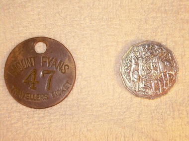
Travellers ticket, Unknown, Unknown - 19th Century
Metal 'traveller's tickets' were issued at the gate of Mt. Fyans to itinerant workers and travellers passing through the district; they could be redeemed at the homestead for a meal and/or a bed for the night at the station workers' lodgings. Mt Fyans was a significant pastoral property in the Dundonnel area of the Western District. Originally settled in 1841 by Lachlan Mckinnon, by 1856 the Mt.Fyans portion comprised over 48,000 acres. By 1898 when it was sub-divided on the death of then owner William Cumming, it comprised 9000 acres. Pastoral properties relied heavily on a semi-skilled workforce whose numbers were seasonally varied - hence the need for itinerant labour. Circular metal 'travellers ticket' with hole punched through at the top for hanging/ storage. MOUNT FYANS 47 TRAVELLERS TICKETmt fyans western district pastoral property workforce intinerant swagmen -
 Mortlake and District Historical Society
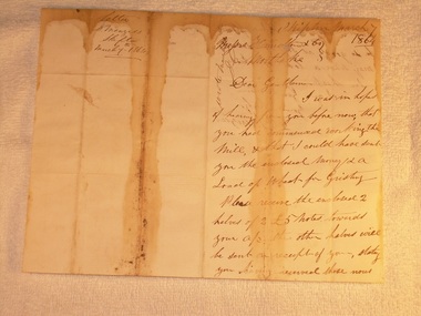
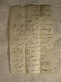
Letter for payment of account Mortlake Mill, March 7 1864
This letter was sent by a customer D. Menzies at Skipton to the Mortlake Mill, detailing an unusual payment method for the processing of his wheat into flour. David Menzies was a Scots farmer who lived in Skipton c. 1860's on a bend in the Mount Emu Creek. He helped establish the local school and a lane in the township bears his name. The letter illustrates the nature of commerce and the difficulties of communication and life generally in the country at the time. The bluestone Mortlake Mill built in 1856, has been a prominent landmark in Mortlake for over 150 years. It played a significant role in the commercial life of the town and was initially a wind-mill to process district grain for sale. The goldrush at Ararat 100 km. away led to a temporarily increased population and demand for foodstuffs. In 1857 the Mill was sold to Aikman, Hamilton and Geddes who converted it to steampower and later built the prominent chimney, which is on the Heritage Register as part of the National Estate. D. Menzies at Skipton lived at least 85 km away - his wheat which urgently needed milling, faced a slow and arduous journey by bullock dray. After the demise of the Ararat goldfields and the decline in population (as well as the district soils proving unsuitable for sustained wheat cultivation), the operation of the Mill declined too and the proprietors increased their involvement in other activities - supply of building materials, timber felling and sawmills. Despite the apparent difficulties of conducting business in the 1850's, it is notable that commerce thrived at that time in country districts, as an examination of Mill accounts and records show.Handwritten letter dated 1864 (water-stained)Skipton March 7 1864 [to] Messrs. Hamilton & Co. Mortlake. Dear Gentlemen, I was in hope of hearing from you before now that you had commenced working the Mill, & that I could have sent you the enclosed money [for a] load of wheat for Gristing. Please receive the enclosed 2 halves of 2 [two] 5 [pound sign] notes forwarded to your account. the other halves will be sent on receipt of your stating you having received those notes sent. As I am out of flour be so good as say how soon I may send a load of wheat. In haste I am Gentlemen Yours truly D. Menziesmortlake mill grain wheat hamilton geddes aikman laang dixie menzies skipton -
 Mortlake and District Historical Society
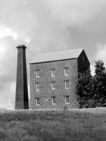
Painting, William Alen, The Old Windmill, 1916
The Old Wind Mill in Mill Street Mortlake was constructed in 1856 by Thos. Bostock. It was erected to process locally-grown grain to supply the increased population of the Ararat goldfields with flour. It was painted in 1916 by W.Alen a local artist, who did not have first-hand knowledge of the old Mill, but would have relied on descriptions from those living in the district who did, as well as possibly recollections of windmills in Europe and Britain. The Mill has been a prominent landmark in Mortlake for over 150 years. It was converted to steam after it was sold in 1857 to Hamilton, Aikman and Geddes. Its use declined after the Ararat goldfields petered out, the diggers moved on and local soils proved unsuited to the sustained cultivation of wheat. The existing Mill Chimney is Heritage listed and is part of the National Estate.1 paintingSigned W.Alenmill windmill mortlake national estate hamilton bostock aikman geddes -
 Mortlake and District Historical Society
Letter
This letter describes a business transaction of an item essential to conducting a mill in the days of the pioneers. The horse was purchased from Francis Jones at Grasmere some 45 kilometres distant. Francis Jones and descendants were closely associated with the settlement of Grasmere (district) and 'The Union', a well-known pastoral property still in existence today.The conduct of business in the 19th century could be slow and arduous. Horses were an essential component of business and communication. Their labour was pivotal to success and so their physical soundness (or otherwise) was vital. The horse trade was open to manipulation by the unscrupulous, selling unfit animals. Veterinary care and treatment was primitive, so a buyer could not be confident of a positive result, despite (as in this case) Jones' assurances of the triviality of the injury and Knights' capabilities. Handwritten letter on paper folden in half - water stained.Grasmere. April 4th 1864. Messrs. Hamilton & Co. I beg to acknowledge the receipt of yours of the 29th March enclosing a cheque for [pound sign] balance of the price of the bay mare for which I am much obliged to you for your punctuality in sending it. I enclose you a receipt for the the (sic) same. With reference to the swelling on the mares leg it could only have been there a very short time before you purchased her. It can easily be removed if the proper remedies are applied. M. Knights the veterinary surgeon will give you medicine that will remove it for a trifle. Hoping the mare will give you ample satisfaction. I am scy. (sic) [sincerely] yours respecfully Francis Jones. mortlake mill hamilton transport communication francis jones grasmere michael knights veterinary surgeon -
 Mortlake and District Historical Society
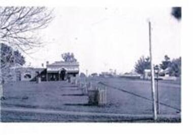
Mortlake Streetscape, Photograph, Late 19th Century
Intersection of Officer and Townsend Streets, Mortlake. Early street lamps and the telegraph line from Hexham to Mortlake Post & Telegraph Office in Shaw Street erected in 1862 are visible. Mount Shadwell Store purchased by A. S. Stewart in the mid 1880's from Clarke & Co. of Geelong. In this photograph one can see the previous two stores - the building in the centre would have been the original Store owned and built by the Rae & Robertson circa 1860 and sold to Grieve & Benn in 1862 - the bulding on the right hand side was the business premises of the Mount Shadwell Store owned by Grieve & Benn later used as a storeroom when the building on the right was erected by them to become the main business premises which John Grieve sold to Clarke & Co. of Geelong in 1882 and they to A. S. Stewart It still operates as a supermarket in 2011.Even though in 2011 a facade now covers the entire front of these three building, the original buildings are still within the fabric of the store and includes a cellar in front of the oldest building. Black and white photographmount shadwell store, bluestone buildings -
 Mortlake and District Historical Society
Photograph, The Mill
-
 Mortlake and District Historical Society
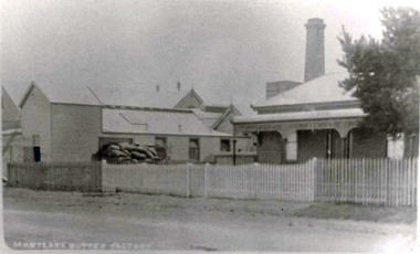
Mortlake Butter Factory Co. Ltd, Photograph
This local factory was typical of small butter factories in the 1890's in Western Victoria. It was established in 1894 when farmers brought their milk to the factory on horse drawn drays and carts and waited for their cream to be separated. The skimmed milk was mostly used by farmers to feed calves and pigs and the separated cream was manufactured into butter, some of which was exported to England. By 1910 this butter factory had an electricity generating plant called Mortlake Electricity which supplied both the factory and the township with power and this took precedence over the butter production which continued until 1926 when it was sold to the Electricity Commission. By 1930 the Butter Factory had a yearly turnover of 24,000 pounds sterling and in1935 it was producing 6 tons of butter weekly. But in 1936 the factory was sold to Glenormiston Cheese & Butter Factory who ceased operations. The manager's residence still remains in 2011 as does the remnants of the small timber butter factory (charcoal lined) and the double brick cheese room but the bluestone chimney has long gone. This complex is listed by Heritage Victoria Black and White Photograph Nonecheese factory, mortlake, butter factory -
 Mortlake and District Historical Society
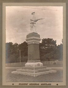
Photograph, Mortlake War Memorial
This memorial was built in 1922 by the Mortlake Shire Memorial Committee (Chairman Cr W. T. Allen) in memory of the forty two district men who died from injuries received during WW1. Financed by public subscriptions, it was designed and built by Messrs Wooles & Carpenter of Warrnambool at a cost of four hundred and fifty pounds sterling and unveiled in the same year by the Shire President Cr G. L. Dennis who presided at the ceremonyt and invited the Premier of Victoria the Honourable H. S. Lawson to unveil the memorial in the presence of a very large crowd which consisted of the Mortlake Brass Band and local schoolchildren. Photograph black and whitemortlake, war memorial dunlop street -
 Mortlake and District Historical Society
Bank of Victoria, Photograph
A branch of the Bank of Victoria was erected from bluestone in Mortlake in 1866. In 1860 improvements were made to the branch in in 1927 the Bank of Victoria mered with the Commercial Banking Co. of Sydney Ltd which later became the National Bank of Australia. This bluestone building was demolished in 1956 to make way for a new brick National Bank of Australia banking chamber and residence. The bluestone was taken to a local property called "Cattle Runs" -
 Mortlake and District Historical Society
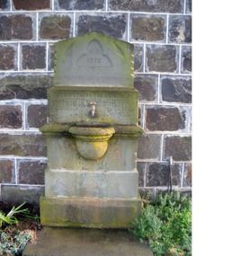
Montgomery Memorial Fountain, Photograph
A memorial fountain was original originally sited at close to the gates of the Mortake State School and was unveiled by the citizens of Mortlake to perpetuate the memory of the late Cr Thomas Montgomery. The fountain was to be erected before the death of Cr Montgomery but as he died before this happened it became a memorial. Made of bluestone and Apollo Bay and Ceres stone it was designed by Messrs Wilcox Bros of Geelong. Cr Dennis as President of the Mortlake Shire Council was the first to turn on the water and take a drink from the fountain which was later removed to the front wall of the Mortlake Swimming Baths and then just recently to the east wall of the newly constructed bluestone toilets in Market Square.Thomas Montgomery served on the Mortlake Shire Council for thirty eight years, and was a local businessman who owned the general store known as Thos Montgomery as well as being a partner in a similar store in Terang known as Montgomery and Bradshaw.AD 1922 ERECTED BY THE CITIZENS OF MORTLAKE TO PERPETUATE THE MEMORY OF THOMAS MONTGOMERYthomas montgomery memorial fountains -
 Mortlake and District Historical Society
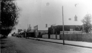
Mortlake Dispatch, Photograph
In 1880, when the Mortlake Dispatch printing office moved from A. S. Stewart's General Store in Officer Street to the site shown in this photgraph, the Editor William Manson and his wife and two daughters lived in the house on right side of the photgraph, William Manson continued from here as editor and printer of the newspaper with his daughter selling newspaper and magazines from the front shop until his death in 1903,after which his son William John took over as editor until his own death in 1910. His mother Mary carried on the business with the help of her two daughters and in 1910 she appointed William John Bray of the Port Fairy Gazette as the editor of the Mortlake Dispatch. Willam Bray or Bill as he was affectionately known married one of the Manson daughters, (Mary Swinton Manson) and the Manson family continued to own the newspaper until the death of Mary Manson Snr in 1928 when it was purchased by Bill Bray. When the shop and building were demolished in about 1938 William Bray moved his printing works and news shop further up Dunlop Street. The Mortlake Dispatch was printed on this site for 58 years firstly by William Manson, then his son and then William BrayBlack and White photgraphmortlake dispatch, william manson and william bray, editors of country newspapers -
Mortlake and District Historical Society
Boer War, photograph
-
Mortlake and District Historical Society
Mt. Shadwell Bush Inn, photograph
This Mount Shadwell Bush Inn erected in 1854 was situated adjacent to one of the main routes to the diggings (Great Western Road), and was originally built from tufa stone obtained from a local quarry. It did a great trade after if first became licensed ub 1855, when it provided a valuable service to the travelling public and to the increasing agricultural population of the area. At that time it contained three sitting rooms, several large reception rooms, fourteen bedrooms, a bar and two taprooms and was the first known hostelry in Mortlake. In 1863 a bluestone addition (probably done by local architect Andrew Kerr) increased the size of the hotel to 23 rooms with a detached billiard room and ballroom, kitchen, servant's apartments, laundry, storeroom, 12 stalled stable, out office, and stock yards for travelling cattle. The present hotel with its 1928 rendered facade, has had an almost uninterrupted licence since 1855 -
 Mortlake and District Historical Society
Photograph - Montgomery Pavillion, Montgomery Pagoda or Pavillion, 1924
In July 1922 Rev. W. McBride of the St Andrews Presbyterian Church, Mortlake had a meeting with the Garden sub-committee to discuss how the 500 pounds sterling bequest from the Late Thomas Montgomery could best be spent. His suggestion was that the money should be spent on either a kiosk, pavillion or recreation hall and pavillion combines with kitchen and fireplace was agreed to with exact site to decided at a public meeting. Cr Montgomery, a local businessman and a councillor, had loved the gardens and had assisted to transform the area from a swamp into a thing of beauty. The design was chosed by his widow who had seen a smilar design in King's Park whilst in Perth so the plans were obtained from that City. The work was carried out by Archibald Cluny McDonald and completed in September 1924. In December 1924 the Montgomery Pagado was unveiled to the public by Cr Wells Brumley after which the Red Cross ladies served tea.THIS TABLET IS DESIGNED TO COMMEMORATE THE GENEROSITY OF THE LATE COUNCILLOR THOMAS MONTGOMERY BY WHOM THIS PAVILLION WAS GRACIOUSLY BEQUEATHED TO THE TOWN OF MORTLAKE AND TO PERPETUATE THE MEMORY OF HIS NOBILITY OF CHARACTER AND EXTREME WORTH AS A CITIZENpagoda -
 Mortlake and District Historical Society
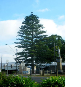
The Peace Tree
This Norfolk Island pine tree was planted in 1919 as 'The Peace Tree'. A community gesture signifying the embrace of 'peace' as a valuable concept symbolised by the planting of a tree. [from Mortlake Dispatch] PEACE DAY 1919. Throughout the Empire three days were marked as Public Holidays including Peace Day in July 1919. Mortlake observed Peace Day by Peace Medals being distributed at the State School, Union Jacks being flown from many buildings and houses and the Peace Tree being planted at the intersection of Officer Street, Jamieson Avenue and Shaw Street. Then followed a procession [of local people]. It is assumed the Progress Association, which undertook the Avenue of Honour, also was responsible for planting the Peace Tree. Norfolk Pine tree located on eastern corner of Officer Street, Shaw Street and Jamieson Avenue intersection.1919, peace, norfolk island pine -
 Mortlake and District Historical Society
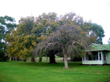
Queen Victoria's Oak Tree
This magnificent English oak tree is located at Tea Tree Lake park in Mortlake. This park was formerly the Botanic Gardens which were developed on what had been swamp land. An artificial lake was created there in 1988 as a Bi-Centenary project.The tree is located adjacent to the historic Montgomery Pavillion and was planted on the occasion of Her Majesty Queen Victoria's birthday on 24th May 1883. An outstanding tree, planted to commemorate a much-revered Queen in an historically-significant Botanic Gardens (now much altered). A very old oak tree planted 1883. queen victoria, mortlake, mortlake botanic gardens, tea tree lake, montgomery pavillion -
 Mortlake and District Historical Society
Lone Pine
This pine tree (Allepo Pine, Pinus halepensis) a native of the Gallipoli Peninisula (Gelibolu, Turkey), was grown from a cutting obtained from the War Memorial Canberra and planted in the Mortlake Botanic Gardens in 2002. It replaces the original which grew outside the Mortlake RSL Hall which blew down in a storm c.2000. That tree (Allepo brutius)came from 'the original on Gallipoli' and was planted to commemorate 'fallen comrades' in 'the Jubilee year 1965.' However, two soldiers first brought home pine cones direct from that fateful battlefield. . One was Sgt. Keith McDowell of the 24th Btn. His aunt, Mrs. Emma Gray of Grassmere (Vic.) planted the seeds c. 1928 and four seedlings resulted. One was planted in Wattle Park, Melbourne, one at the Shrine of Remembrance, one at the Soldier's Memorial Hall at The Sisters (c.15 km. south of Mortlake) and one at the Warrnambool Botanic Gardens. The First World War (or 'Great War') and in particular the battle for the Gallipoli Peninsula is of immense national significance. Lone Pine or Plateau 400 was the scene of a major offensive on August 6th 1915. All the trees on the ridge at this point were cut down but one, which was dominated by the 'Lone Pine'. In three days of fighting more than 2,000 Australians lost their lives and seven Victoria Crosses were won. Two Australian soldiers souvenired pine cones - one was brought back to Victoria (see above). Many young men from Mortlake and district volunteered to fight in the Great War and the presence of this tree in our Gardens reminds us all of the local as well as the national sacrifice.l pine tree Small plaque on railing western side. gallipoli, lone pine first world war great war mcdowell, keith -
 Mission to Seafarers Victoria
Photograph - Photograph, Black and white, Allan Charles Quinn, Landing Docks, 30 September 1949
Allan Charles Quinn went to sea aged 16 and photographed his work and the places he visited. His collection of photo albums provides a pictorial autobiography for a period in his life. Included in the Allan Charles Quinn Collection are a series of letters written to and from his mother.Black and white photograph of landing docks at San Francisco. To the right of the photograph is the streetscape which includes a walking track and street lighting in front of a road and row of shops or houses. To the centre of the photograph are the ramps to reach the jetty where the yachts are moored. To the left of the photograph are the bows of a long line of yachts. In the background of the photograph there is a large multi-storeyed building.Blue/green ink, handwritten on reverse: "30/9/49" Handwritten in pencil: "K9/A"san francisco, sailing boats, ramps, promenades, allan charles quinn -
 Greensborough Historical Society
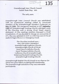
Book, Rosalie Bray, Greensborough InterChurch Council: by Rosie Bray, 2011_
The Greensborough InterChurch Council was formed in 1989 as an ecumenical group with a strong Christ based mission statement. This book documents the Council until 2003.Detailed information about the people and church communities involved in the Greensborough InterChurch Council, written by Rosie Bray, committee member.33 pages, colour and black and white illustrations. Includes copies of memorabilia from the Inter Church Council and newspaper articles.. greensborough inter church council, new life centre, greensborough anglican church, greensborough church of christ, saint marys catholic church, saint thomas catholic church, lutheran church greensborough, watsonia macleod uniting church greensborough uniting church -
 Greensborough Historical Society
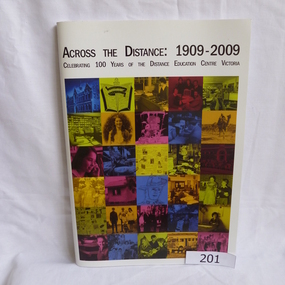
Book, Distance Education Centre Victoria, Across the distance: 1909-2009. Celebrating 100 years of the Distance Education Centre Victoria, 1909-2009
A brief history of the Distance Education Centre Victoria, previously the Victorian Correspondence School. Contains selected examples of students and their work.Soft cover. 97 pages, illus (some colour). Front cover has a collage illustrating distance education work over 100 years.distance education centre victoria, jenny campbell, victorian correspondence school -
 Greensborough Historical Society
Book, Nillumbik Shire Council, 1997 Community Guide Nillumbik, 1997_
Guide to services provided by Nillumbik Shire Council. Nillumbik Shire is located 25 kilometres north-east of Melbourne and the southern boundary is the Yarra River. The south of Nillumbik is predominantly urban, with commercial centres at Eltham and Diamond Creek. The north of the municipality includes significant natural features like Kinglake National Park and Sugarloaf ReservoirAnnual guide to services in Nillumbik. 64 pages. Cover is pale yellow with colour drawings. nillumbik shire council, handbooks -
 Greensborough Historical Society
Book, Nillumbik Shire Council, 1998 Community Guide Nillumbik, 1998_
Guide to services provided by Nillumbik Shire Council. Nillumbik Shire is located 25 kilometres north-east of Melbourne and the southern boundary is the Yarra River. The south of Nillumbik is predominantly urban, with commercial centres at Eltham and Diamond Creek. The north of the municipality includes significant natural features like Kinglake National Park and Sugarloaf ReservoirAnnual guide to services in Nillumbik 72 pages. Cover has white background and some 3-D artwork.nillumbik shire council, handbooks -
 Greensborough Historical Society
Book, Nillumbik Shire Council, 1999 Community Guide Nillumbik, 1999_
Guide to services provided by Nillumbik Shire Council. Nillumbik Shire is located 25 kilometres north-east of Melbourne and the southern boundary is the Yarra River. The south of Nillumbik is predominantly urban, with commercial centres at Eltham and Diamond Creek. The north of the municipality includes significant natural features like Kinglake National Park and Sugarloaf ReservoirAnnual guide to services in Nillumbik76 pages, illus. Cover has photographs of local people and title in white on orange background.nillumbik shire council, handbooks -
 Greensborough Historical Society
Book, Nillumbik Shire Council, Nillumbik Community Guide 2000/2001, 2000-2001
Guide to services provided by Nillumbik Shire Council. Nillumbik Shire is located 25 kilometres north-east of Melbourne and the southern boundary is the Yarra River. The south of Nillumbik is predominantly urban, with commercial centres at Eltham and Diamond Creek. The north of the municipality includes significant natural features like Kinglake National Park and Sugarloaf ReservoirAnnual guide to services in Nillumbik76 pages, black and white illustrations. Cover has a collage of local children with title in white on mid-blue background.nillumbik shire council, handbooks -
 Greensborough Historical Society
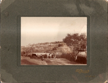
Photograph, Willis Vale 1906, taken from the hill, 1906_
'Willis Vale' home of the Partington family is shown in this photograph as well as the area now known as Partington's Flat. The area was owned and farmed by the Partington family from the 1870s. The derelict Willis Vale house was destroyed in 1964 when a fire originating from North Plenty Gorge - Kurrak Road - lit by two teenage boys - made its way several kilometres down to Partington's Flat Greensborough.Photograph shows an early view of Greensborough in 1906.Professional photograph in sepia mounted on dark green card. Shows Greensborough township in background with Willis Vale homestead in centre. On back: A.M.Partington Greensborough 1906.willis vale, partington family, greensborough, alan partington -
 Greensborough Historical Society
Newspaper Clipping, Diamond Valley Leader, 40 years young: Greensborough Plaza, 14/11/2018
Includes 2 p. of captioned photographs illustrating development of the Greensborough Plaza shopping centre4 p. supplement in colourgreensborough plaza -
 Greensborough Historical Society
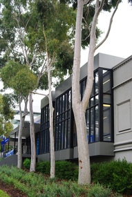
Photograph - Digital Image, Marilyn Smith, Primary Medical Centre, 9-13 Flintoff Street Greensborough, 18/06/2018
Views of Primary Medical Centre, 9-13 Flintoff Street Greensborough. This building was previously Banyule Council's Greensborough offices. Banyule Council offices are now (2018) situated on the Watermarc site.Digital colour photographsflintoff street greensborough, primary medical centre greensborough -
 Greensborough Historical Society
Newspaper Clipping, Diamond Valley Leader, Charging ahead with new stations, 06/02/2019
Greensborough Plaza is getting even greener with the addition of four news electric car charging stations at the centre.News article 1 page, black text.greensborough plaza, electric car charging stations