Showing 247 items
matching city of moorabbin council
-
 City of Moorabbin Historical Society (Operating the Box Cottage Museum)
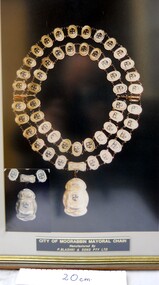
Photograph - Photograph , City of Moorabbin Mayoral Chain, circa 1990
... . Moorabbin City Council supported their efforts until ...City of Moorabbin was proclaimed 1934 and managed the areas of Cheltenham, Highett, Moorabbin, Bentleigh, East Bentleigh, East Brighton, McKinnon, Ormond until the Amalgamation of Councils in 1994. The City of Kingston then took over the area south of South Road while City of Glen Eira took the area to the north Kingston City Council possesses the original Mayoral Chain of former City of Moorabbin and it is displayed on the Moorabbin Mayoral Robe at KCC Office Cheltenham for the Annual Opening meeting of KCC in February . 2018 The Moorabbin Mayoral Robe was sent on 7 year loan to KCC for display at Cheltenham with the former City of Chelsea and former City of Mordialloc Mayoral Robes.Since the 1960s far-sighted community members have generously donated many significant items to the ‘Box Cottage’ museum, specifically to provide future generations with a fascinating, and tangible insight into day-to-day life from the 1800’s and up to the mid 1900's. Moorabbin City Council supported their efforts until the Amalgamation of Councils 1994. The City of Kingston donated the 1990 City of Moorabbin Mayoral Robes in 2007 Photograph of the City of Moorabbin Mayoral Chain circa 1990 in a glass covered, wooden frame Photograph of Mayoral Chain worn by Kingston City Council Mayor Steve Staikos, with Councillor Brownlees, in November 2018 when Robe and Jabot were loaned to KCC by CMHS Box Cottage MuseumPlate at base of photograph frame states ' City of Moorabbin Mayoral Chain /Manufactured By / P. Blashki & Sons Pty.Ltd'/moorabbin, kingston, mayors, glen eira, mayoral chain, moorabbin shire -
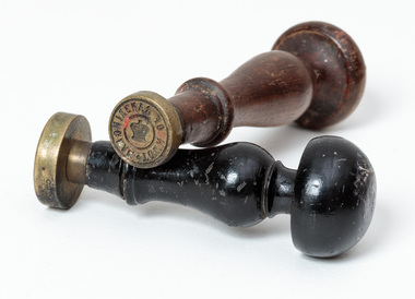
 City of Moorabbin Historical Society (Operating the Box Cottage Museum)
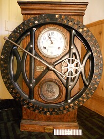
Functional object - Punch Clock, manual, circa 1880
... defunct Moorabbin City Council in 1984. moorabbin clocks wages ...The large, early, manual, ‘Punch-Clock’, (also known as a Time Clock), used by the Shire of Moorabbin employees to “clock-on and off” each working day circa late 1800s early 1900s.This 'Punch-Clock' was used by employees of the Shire of Moorabbin circa 1880 - 1900 and was donated to the City of Moorabbin Historical Society by the now defunct Moorabbin City Council in 1984.The large manual, ‘Punch-Clock’, (also known as a Time Clock), used by the Shire of Moorabbin employees to “clock-on and off” each working day circa late 1800s early 1900s. The clock face is exposed and the internal mechanism is encased in a wooden cupboard with two glass framed side panels. Right side panel is a door that accesses the clock mechanism.Around Centre of Clock face " DEY TIME REGISTERS LTD"/ "HOWARD BROS./ made in USA/ 75 Queen Victoria St./ LONDON E.C."/ On Brass plate at base are Patent registrations moorabbin, clocks, wages, punch clock -
 City of Moorabbin Historical Society (Operating the Box Cottage Museum)
Photograph - Map of Dendy's Special Survey, 1852 Map of Henry Dendy's Special Survey of 1841, 19th Century
A Map drawn in 1852 that shows the 5,120 acres that formed Dendy's Special Survey of 1841. In 1840 Henry Dendy, a farmer in Surrey, England acquired a "Special Survey" from the Commissioners for Land and Emigration which gave Dendy the right to choose land in Port Phillip for the "bargain basement" price of only £1 per acre for 5120 acres, (an area of 8 square miles). The Special Survey also included the right to "the shipment of a worker for every £20 spent on land, whose free passage was paid by the Crown, equalling a total of 100 workers ". Accordingly Dendy sold his English holdings and paid the required £5120 and arrived in Melbourne in February 1841. However by this time land in the new colony was selling for £5 - £40 per acre. Because Henry Dendy possessed the order from the Colonial Office in London he was able to successfully oppose Governor LaTrobe's attempts to alter the price of the land. Dendy appointed Jonathan Were, (an entrepreneur, who had arrived in 1839), as his Manager and who later became a partner. Together, Dendy and Were decided on an area 5 miles south from Melbourne, bounded by North Road, East Boundary Road, South Road and to the west by Port Phillip Bay. Were and Dendy pitched their tents in the area now known as ' Park St, Brighton' and sank a well near the corner of 'St Andrew's St and Wells St'. By 1845 J.B Were and Company had bought almost half of Dendy's land and Were built himself "Moorabbin House" in Were St Brighton made from stone, quarried from local cliffs. It was still standing in 1924. Legend records Moorabbin is named after the Aboriginal word for ' Mother's Milk ' The soil is very fertile and well supplied with water especially in the area called 'East Brighton' - now known as Bentleigh and East Bentleigh - By 1850 the area had developed with numerous market gardens, dairy farms, fruit gardens and vineyards supplying food for the growing population of Melbourne.This Map shows the birth of the Brighton and Moorabbin area. On 18th January1859 Brighton was proclaimed a Municipality and a Borough by October 1863. Meanwhile, following a Petition, the area of East and South Brighton, incorporating Mordialloc, Cheltenham, Mentone, Sandringham and Oakleigh separated from Brighton to form the Moorabbin District Roads Board becoming the first Local Government Authority. Col. William Mair was elected as the first Chairman of the Moorabbin Roads Board. Moorabbin Shire 1871 developed further and was declared a City in1934. The City of Moorabbin was the largest Municipality in Melbourne before the Amalgamation of Councils in 1994 when it was divided in the south to City of Kingston and in the north to City of Glen Eira A Photo-lithographed 1852 Map showing the 5,120 acres that formed Dendy's Special Survey of 1841. Henry Dendy & Jonathan Were chose an area 5 miles south from Melbourne, bounded by North Road, East Boundary Road, South Road and to the west by Port Phillip Bay. Moorabbin County of Bourke / Photo-Lithographed at the department of Lands and Survey. /Melbourne. / Price 1/- brighton, moorabbin, bentleigh, cheltenham, dendy henry, bent thomas, were jonathan, special survey -
 City of Moorabbin Historical Society (Operating the Box Cottage Museum)
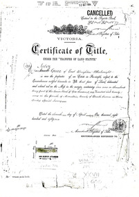
Document - Photocopy of Land Title 1881, c1881
This is a Certificate of Title for an acre of land in 'Tucker's Road' purchased by Jabez Gurr in 1881, in the area that was part of the Crown Block known as Henry Dendy's Special Survey 1841, in the Parish of Moorabbin, County of Bourke, Victoria. Following the 'Transfer of Land Statute' allotments in the area of Henry Dendy's Special Survey of 1841 were sold to early settlers. This Certificate of Title shows the passage of history in Moorabbin Shire . Jabez Gurr, a wheelwright, of East Brighton, now Bentleigh East, purchased an acre of land in 'Tucker's Road' , near Centre Road, in 1881. In 1889 he sold to a produce merchant, Robert Smith, and in April 1916 this block was purchased by William Henry George Box, a market gardener and relative of William and Elizabeth Box, who owned the land until 1926. The land was then purchased by Charles John Greenlaw Coates and remained with this family until 1971. All these Family names appear on Councils and Community Boards during the foundation and development of City of Moorabbin3 photocopied pages of the Certificate of Title for approximately 1 acre of land near the corner of Centre Road and Tucker Road, Parish of Moorabbin, County of Bourke, Victoria that was part of the 5,120 acre Henry Dendy Special Survey in Brighton in 1841 and purchased in 1881 by Jabez Gurr. It records subsequent proprietors up to 1971Stamped CANCELLED 12 OCT 1994 (top Right) / Entered in the Register Book / Vol.1245 Fol. 248877/ signed Henry Crowe / Assistant Registrar of Titles / Coat of Arms / VICTORIA / Certificate of Title / UNDER THE ' TRANSFER OF AND STATUTE' /dated ' eleventh day of April one thousand eight / hundred and eighty one' / signed 'Henry Crowe' / Assistant Registrar of Titles/ ENCUMBRANCES REFERRED TO / circular Stamp 'OFFICE OF TITLES VICTORIA' / Drawn and shaded on the left side is the area of land in "Tucker's" Road 3331/3 links fro Centre Road, 150 links x 6662/3 links / The measurements are in linksdendy henry, dendy's special survey 1841, brighton, moorabbin, bentleigh, market gardeners, early settlers, pioneers, wheelwrights, merchants, fruit gardens, markets, smith robert, box william henry george, gurr jabez, county of bourke, victoria, melbourne, land statutes, tucker road, centre road, box william, box elizabeth, box cottage museum -
 City of Moorabbin Historical Society (Operating the Box Cottage Museum)
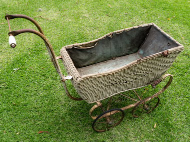
Functional object - Manufactured Objects, Perambulator, c1914
... moorabbin city council... city council moorabbin roads board toll gates pioneers moorabin ...JAMES JOSEPH HIGGINS, was born in Dublin in 1821 and, at age twenty, emigrated via Liverpool in 1841 with his wife Ellen and baby daughter Margarete, on board the 'Intrinsic'. They lived in Little Lonsdale Street, Melbourne, for some years, where their son James John Clarke Higgins was born in 1850. JAMES JOHN CLARKE HIGGINS moved to Brighton East when he married Ruth Simmonds in 1873. The couple lived on Jasper Rd near the corner of Centre Rd for the rest of their lives, and produced eight children HERBERT JOHN HIGGINS was the sixth child born in 1886, to James John Clarke Higgins and Ruth Simmonds, and grew up in Centre Rd, Brighton East, now Bentleigh. He was renting and working a property on Jasper Rd from the time he was married in 1913 to Victoria Matilda Long, daughter of Charles John Long and Annie Matilda Allnutt. Herbert John bought his property on Jasper Rd in 1921. [Metropolitan Board of works plan 3220, Municipality of Moorabbin, shows that in 1928, Higgins Rd was planned (and probably built soon after). Herbert was a dairyman and market gardener. He bred and milked cows and sold milk, cream, butter and eggs to the locals. He supplied hay/corn to be made into chaff to J L Smith’s produce store. He also leased land from other farmers in the area and helped work their land. c1950 he sold the property in lots, some privately, others to the Municipality. Some lots became part of Hodgson Reserve, Higgins Road, Bentleigh, and another lot, the Bentleigh Bowling Club. Herbert and Victoria, known as Queenie, had five children between 1914 and 1928. The youngest Dorothy, who remembered sitting in this pram and later using it to carry papers, wood, vegetable etc., lived on the property in Jasper Road until her passing in 2016. ( Ronald Alexander Higgins, descendant , Helen Stanley CMHS 2017) The family of Dorothy Higgins 1928-2016, were early settlers in Moorabbin Shire establishing a dairy farm c 1873 in East Brighton ( now Bentleigh)Wicker Perambulator, baby carriage, c. 1914, with a lined, painted wicker body, iron spring scrolled frame with leather straps and 4 steel wheels with rubber tyres. The push handle is broken and hood is missing. dairy farms, higgins james joseph, simmonds ruth, higgins dorothy, poultry farms, jasper road bentleigh, city of moorabbin historical society 1961, sheehy t.a., newsletters, ashley r, neville f, blackman n, moorabbin city council, moorabbin roads board toll gates, pioneers moorabin cheltenham, bentleigh, highett -
 City of Moorabbin Historical Society (Operating the Box Cottage Museum)
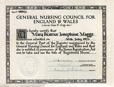
Certificate - General Nursing Council for England and Wales Certificate England, Mary Beatrice Josephine Maggs, 20 July 1923
Mary Beatrice Josephine Maggs (1892-1960) came to Australia in 1914 and was a governess for Mr Alfred Rutter Clarke at his mansion "Merriwa" on Orrong Road, Toorak. Mary returned to England in 1919 and furthered her studies in nursing. When she returned to Australia in 1924 she was head nurse at a number of Hospitals, Private Hospital in Loch, Tatura Bush Nursing Home, Mooroopna.Certificate of General NursingGeneral Nursing Council for England and Walesmaggs mary, medicine, nursing, thompson jean, hospitals, early settlers, pioneers, melbourne hospital -
 City of Moorabbin Historical Society (Operating the Box Cottage Museum)
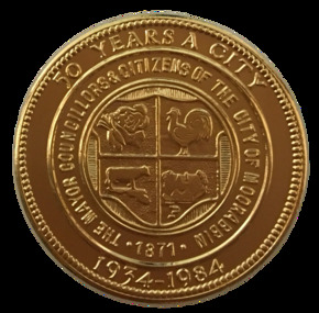
Badge - City of Moorabbin - 50 Years Medal, 1984-85
A gold-plated medal issued by the City of Moorabbin to commemorate the quincentenary of Victoria in 1984-5. It features the City Shield incorporating vegetables, a rooster, a cow and a house, and the sesquicentenary logo. The township of Moorabbin, known as South Brighton until 1909, remained small, with the Plough and Harrow Hotel as its main building. In 1917 Sandringham borough was formed by severance from Moorabbin shire and in 1920 Mentone and Mordialloc were also severed. In the remaining Moorabbin shire the Moorabbin township was still small (1,770 persons), but the shire grew in population during the 1930s. On 10 October 1934 it was proclaimed a city. It existed as a separate municipality until 1995. When local government boundaries were changed in 1994 about half of Moorabbin city was united with Glen Eira city and about half with Kingston city. On 15 December, 1994 the City of Chelsea, parts of the Cities of Mordialloc, Moorabbin, Springvale and Oakleigh were amalgamated to create the City of Kingston by Order of the Governor in Council. On the same day Glen Eira City Council was formed from the City of Caulfield and the remaining part of the City of Moorabbin.Gold Plated Medal Side one: Within a wide rim formed by a line circle, the City Shield incorporating vegetables, a rooster, a cow and a house; around, THE MAYOR COUNCILLORS & CITIZENS OF THE CITY OF MOORABBIN; around on broad rim, 50 YEARS A CITY 1934 - 1984. Side 2: Logo of the Victorian sesquicentenary; below, VICTORIA 150 / GROWING TOGETHER 1984-5 at rim in small letters the mint name, BRIM MELBTHE MAYOR COUNCILLORS & CITIZENS OF THE CITY OF MOORABBIN; VICTORIA 150 / GROWING TOGETHER 1984-5.city of moorabbin, victorian sesquincentenary, moorabbin shire, councillors moorabbin, cheltenham, bentleigh, moorabbin, le page family, cr coates l.r, cr sheppard l.a., cr cooper j.c. -
 City of Moorabbin Historical Society (Operating the Box Cottage Museum)
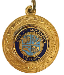
Badge - City of Moorabbin Key Chain
“City of Moorabbin” The township of Moorabbin, known as South Brighton until 1909, remained small, with the Plough and Harrow Hotel as its main building. In 1917 Sandringham borough was formed by severance from Moorabbin shire and in 1920 Mentone and Mordialloc were also severed. In the remaining Moorabbin shire the Moorabbin township was still small (1,770 persons), but the shire grew in population during the 1930s. On 10 October 1934 it was proclaimed a city. It existed as a separate municipality until 1995. When local government boundaries were changed in 1994 about half of Moorabbin city was united with Glen Eira city and about half with Kingston city. On 15 December, 1994 the City of Chelsea, parts of the Cities of Mordialloc, Moorabbin, Springvale and Oakleigh were amalgamated to create the City of Kingston by Order of the Governor in Council. On the same day Glen Eira City Council was formed from the City of Caulfield and the remaining part of the City of Moorabbin.Gold Key ring with a dark blue circle surrounding the shield of the City of Moorabbin.City of Moorabbin, Victoria,city of moorabbin -
 City of Moorabbin Historical Society (Operating the Box Cottage Museum)
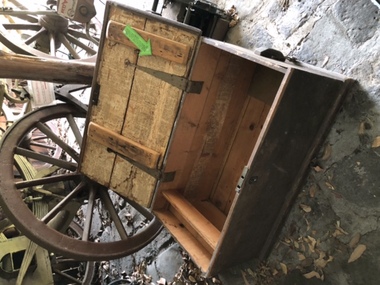
Functional object - Travel Trunk, c 1851 wood, brass lock and hinges and Guernsey Newspaper 1851, c1851
This wood traveling trunk was used by the LePage family when emigrating from Guernsey , Channel Isles, to Melbourne on SS Caliope 1852. Nicholas LePage , a tailor, and wife Elizabeth arrived in Melbourne in 1852 with their son Frank Thomas and daughter Elizabeth. Joshua Holloway released land in his 'Two Acre Village' in Cheltenham 1851. Nicholas bought a LOT for 10pounds and began a market garden that was managed by successive generations. The LePage family became involved with the Methodist Church , local friendly societies, sporting clubs and civic councils that endured. 'The LePages became one of the best known Moorabbin market gardening families, with a tradition of service to communal and civic affairs that is unmatched' John Cribbin, ' Moorabbin ,Pictorial History 1862-1994.' (City of Kingston)A handmade wood trunk with brass lock and hinges and Guernsey ( Channel Isles) Newspaper lining 1851Top of lid; White Stencil BETSEY LEPAGE / PASSENGER TO MELBOURNE Lining of box; Guernsey Newspaper 1851 henry dendy's special survey 1842, moorabbin shire, moorabbin roads board, dendy henry, were jb, holloway josiah, brighton, bentleigh, cheltenham, pioneers, market gardeners, early settlers, methodist church, two acre village cheltenham, charman stephen, bent thomas, daphne cottage, sons of temperance friendly society, mayors moorabbin council, lepage nicholas, lepage frank thomas, lepage everest, lepage frank wilbur, cheltenham co-operative society, cheltenham cream and butter factory -
 City of Moorabbin Historical Society (Operating the Box Cottage Museum)
Newsletter - City of Moorabbin Historical Society No. 4 Vol. 2 July 1962, 1962
... moorabbin city council...-operative society limited ashley r moorabbin city council standard ...This is Newsletter No 4 Vol 2. produced in July 1962 by Mr T. A. Sheehy President CMHS for members and visitors The Aims of the CMHS are ‘to record the history of the City, and register something of the Australian Atmosphere, which the necessary speed-up in post-world-war two (WW11) immigration has caused to be lost; to produce a magazine at regular intervals, featuring the work of pioneers and the changing Australian scene; to work constantly with a long range view towards building a hall where records and exhibits can be housed’ The Original Newsletters reflect the history and heritage of the former City of Moorabbin — derived from Mooroobin, ‘a resting place’ in the Bunurrung spoken language. In 1994, the City of Moorabbin was integrated into the Cities of Bayside, Glen Eira, Kingston and Monash.This is Newsletter No 4 Vol 2. produced in July 1962 by Mr T. A. Sheehy President CMHS for members and visitors CMHS obtained a Kingston City Council Community Grant 2016 for the digitization and preservation of these Original CMHS Newsletters commenced in 1961Foolscap L34cm x W 21cm paper folded into 4 pagesCITY OF MOORABBIN HISTORICAL / SOCIETY / (Affiliated with the Royal Historical Society of Victoria ). President T.A.Sheehy …… Secretary Mrs L. Harvey……. NEWSLETTER No 4 Vol. 2 JULY 1962city of moorabbin historical society 1961, sheehy t.a., harvey l, cheltenham & district co-operative society limited, ashley r, moorabbin city council, standard newspapers ltd., bent thomas, aboriginals, shipston -
 City of Moorabbin Historical Society (Operating the Box Cottage Museum)
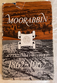
Book, Thomas Arthur Sheehy, Moorabbin : a centenary history, 1862-1962, 1962
... Published for the Moorabbin City Council by J. & E... for the Moorabbin City Council by J. & E. Handfield (Public Relations) ...History of Moorabbin and surrounding suburbs that were part of the Moorabbin Roads Board, Moorabbin Shire, Moorabbin Council.96 p., 24 leaves of plates : ill. ;non-fictionHistory of Moorabbin and surrounding suburbs that were part of the Moorabbin Roads Board, Moorabbin Shire, Moorabbin Council.moorabbin, moorabbin history -
 City of Moorabbin Historical Society (Operating the Box Cottage Museum)
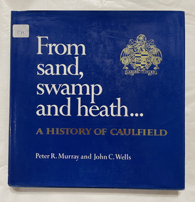
Book, Murray, Peter R. et al, From sand, swamp and heath : a history of Caulfield, 1980
278p. : ill., graphs, maps, portrs. includes index.non-fictioncaulfield history, caulfield council -
 City of Moorabbin Historical Society (Operating the Box Cottage Museum)
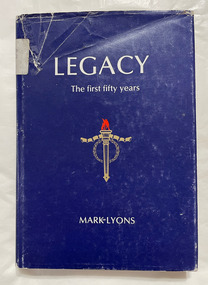
Book, Lyons, Mark, Legacy : the first fifty years, 1978
Welfare services for families of ex-servicemen. Organisations. Australia. Legacy Clubs of Australia, 1923-1973xviii,283p. : ill. ; Index. Bibliography: p.264-270.non-fictionWelfare services for families of ex-servicemen. Organisations. Australia. Legacy Clubs of Australia, 1923-1973 legacy, welfare, ex-servicemen -
 Bayside Gallery - Bayside City Council Art & Heritage Collection
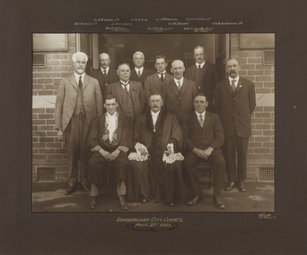
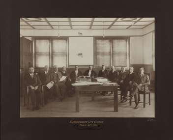
Photograph - gelatin silver photograph, Sarony & Co, The Councillors and Officers of the first City of Sandringham Council, 1923
This photograph records the Councillors and officers on the day that the Town of Sandringham became a City, and the first meeting of the City of Sandringham Council was held. Sandringham was originally part of the Shire of Moorabbin. On 28 February 1917, Sandringham was severed from Moorabbin and incorporated as the Borough of Sandringham. It was proclaimed a Town on 9 April 1919 and a City on 21 March 1923. city of sandringham, councillors, local government, municipality, mayor, cr. h.b. grace, cr. w.h. kay, cr. j.m. ramsay, cr. f.n. gibbs, cr. g.w. knott, cr. r. chisholm, t.g. farrant, cr. c.a. hartsmann, m.h.t. williams, town clerk, cr. j.t.d. beck, m.w.t. sanderland, surveyor -
 Bayside Gallery - Bayside City Council Art & Heritage Collection
Ceremonial object - Seal, Town of Sandringham and City of Sandringham seals
Council's seals were stamped into hot wax to officialise documents. Sandringham was originally part of the Shire of Moorabbin. On 28 February 1917, Sandringham was severed from Moorabbin and incorporated as the Borough of Sandringham. It was proclaimed a Town on 9 April 1919 and a City on 21 March 1923.Two round brass seals on wooden handles. The longer brown wooden handle seal reads around edge 'TOWN OF SANDRINGHAM' with an illustration of St Edward's crown in centre. The black wooden-handled seal reads around edge 'CITY OF SANDRINGHAM' with an illustration of St Edward's crown in centre. Both seals have mushroom-shaped tops and tapered arms.There are remnants of red wax on both seals.seal, common seal, stamp, town of sandringham, city of sandringham, writing accessory, wax seal, bayside -
 Bayside Gallery - Bayside City Council Art & Heritage Collection
Map, Department of Crown Lands and Survey et al, Moorabbin, County of Bourke, Government Roads, 1920
The cadastral map of the Parish of Moorabbin in Victoria (L.6104) shows parish boundaries and land ownership 1920 when Sandringham was a Town. The government roads have been coloured in red pencil.moorabbin, county of bourke, map, plan, land subdivision, land titles, foreshores, hampton, beaumaris, highett, cheltenham, department of lands and survey, land owners, cartographic material, brighton, sandringham, town of sandringham, government roads -
 Bayside Gallery - Bayside City Council Art & Heritage Collection
Map, Department of Lands and Survey, Land under the control of the City of Sandringham, 1962
The cadastral map showing land under the control of the City of Brighton in 1962.map, plan, foreshores, sndringham, hampton, beaumaris, cheltenham, department of lands and survey, cartographic material, moorabbin, black rock, street map, city of sandringham, board of lands and works -
 Bayside Gallery - Bayside City Council Art & Heritage Collection
Map - print, Melbourne and Metropolitan Board of Works, Interim development order: Brighton, Moorabbin and Sandringham, 1959
The Melbourne and Metropolitan Board of Works (now Melbourne Water) was established in 1891. From that time, as part of their work laying water and sewerage connections, they created detailed plans of houses and other buildings in the Melbourne metropolitan area. In 1956 it acquired powers to construct and maintain highways and bridges, protect and improve the foreshores and create and maintain parks within the metropolitan region. This Interim development order comprises part of the municipalities of Brighton, Moorabbin and Sandringham and was made on 20 October 1959.brighton, moorabbin, sandringham, melbourne and metropolitan board of works, map, town planning, cartographic material, interim development order, bayside -
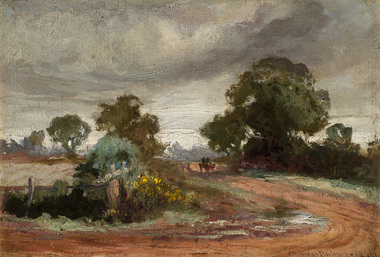 Bayside Gallery - Bayside City Council Art & Heritage Collection
Painting - oil on canvas on board, Charles Douglas Richardson, After the rain, Moorabbin, 1910
oil on canvas on boardlandscape, moorabbin, road, charles douglas richardson, horse, cart, tree, farm -
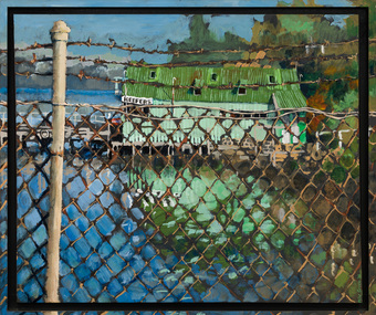 Bayside Gallery - Bayside City Council Art & Heritage Collection
Painting - acrylic on canvas, Mike Green, Keefers, 1976
In the early 1900s, Melbourne builder Charles Keefer was hired by the Moorabbin Council to build the municipal baths at Beaumaris. In 1903, Keefer took over the Beaumaris Boat House and enlarged it to form Keefer's Boat Shed where day trippers and holiday makers could hire boats and venture out into the bay. Although rebuilt following the devastating storms in 1934, Keefer’s Boat Shed was completely destroyed by fire in 1984.Realismkeefer's, boatshed, bayside, coast, beaumaris, fence, water, bay, charles keefer, pier, mike green -
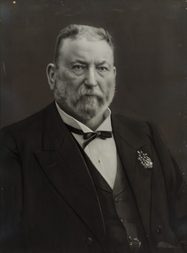 Bayside Gallery - Bayside City Council Art & Heritage Collection
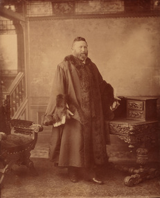
Photograph - gelatin silver photograph, Talma & Co, Sir Thomas Bent, c. 1907
sir thomas bent, thomas bent, speaker, mayor, premier, brighton, moorabbin, land speculator, local government, councillor, official, member of lower house, portrait, parliament -
 Bayside Gallery - Bayside City Council Art & Heritage Collection
Photograph - sepia photograph, Councillor Thomas Bent, Mayor of Brighton
thomas bent, politician, mayor, premier, land speculator, speaker, local government, councillor, member of lower house, portrait, brighton, moorabbin, mayoral robes, mayor of brighton, premier of victoria -
 Bayside Gallery - Bayside City Council Art & Heritage Collection
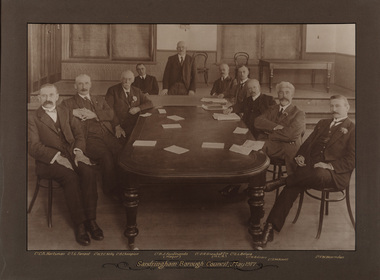
Photograph - sepia photograph, Frazer and Vallance, Sandringham Borough Council, May 1917, 1917
Councillors and the mayor seated at table while attending the first Sandringham Borough Council meeting after severance from the Shire of Moorabbin. Shown L to R: Cr. C.A. Hartsman; Cr. T.G. Farrant; Cr. W.T.C. Kelly; Cr. B. Champion; Cr. B.J. Ferdinando (Mayor) [standing]; Cr. O.R. Snowball Esq. (M.L.A.); Cr. E.L. Belyea; Cr. H. B. Grace; Cr. G.W. Knott; Cr. F.W. Hearnden.councillor, sandringham, local government, municipality, mayor, justice of the peace, cr b.j. ferdinando, borough of sandringham, cr. c.a. hartsman, cr. t.g. farrant, cr. w.t.c. kelly, cr. b. champion, cr. o.r. snowball, cr. e.l. belyea, cr. h. b. grace, cr. g.w. knott, cr. f.w. hearnden, council meeting -
 Bayside Gallery - Bayside City Council Art & Heritage Collection
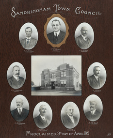
Photograph - gelatin silver photograph, Talma & Co, Sandringham Town Council, Proclaimed 9th day of April,1919, 1919
Sandringham was originally part of the Shire of Moorabbin. On 28 February 1917, Sandringham was severed from Moorabbin and incorporated as the Borough of Sandringham. It was proclaimed a Town on 9 April 1919 and a City on 21 March 1923. The Sandringham Town Hall, located on Abbott Street, Sandringham (formerly the mechanics institute) was demolished in 1994.councillor, sandringham, local government, municipality, mayor, portrait, city of sandringham, sandringham town hall, abbott street, cr. e.l. belyea, cr. b. champion, cr. h.b. grace, cr. c.a. hartsman, cr. j.e.d. beck, cr. b.j. ferdinado, cr. t.g. farrant, cr. w.t.c. kelly, cr. g.w. knott, town, proclamation, bayside, hampton, black rock -
 Bayside Gallery - Bayside City Council Art & Heritage Collection
Photograph - gelatin silver photograph, Sarony & Co, The first meeting of the City of Sandringham Council, 21st March, 1923, 1923
Photograph taken on the day that the Town of Sandringham became a City, and the first meeting of the City of Sandringham Council. Sandringham was originally part of the Shire of Moorabbin. On 28 February 1917, Sandringham was severed from Moorabbin and incorporated as the Borough of Sandringham. It was proclaimed a Town on 9 April 1919 and a City on 21 March 1923.councillor, sandringham, local government, municipality, mayor, cr. c.a. hartsman, cr. t.g. farrant, cr. g.w. knott, cr. f.n. gibbs, h.t. williams, town clerk, engineer, cr. j.t.d. beck, b.r. sunderland, cr. w.h. kay, cr. r. chisholm, cr. h.b. grace, cr. j.m. ramsay, city, proclamation, council meeting, city of sandringham -
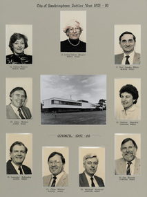 Bayside Gallery - Bayside City Council Art & Heritage Collection
Photograph, City of Sandringham Jubilee Year 1923-83, 1983
Sandringham was originally part of the Shire of Moorabbin. On 28 February 1917, Sandringham was severed from Moorabbin and incorporated as the Borough of Sandringham. It was proclaimed a Town on 9 April 1919 and a City on 21 March 1923. This compilation marks the Jubilee year of the City of Sandringham.sandringham municipal office, councillor, mayor, portrait, municipal building, sandringham, bayside, cr. carmen watson, cr. lesley falloon, cr. paul gundry-white, cr. john merkus, cr. pauline reynolds, cr. laurence bottomly, cr. clem waters, cr. michael harwood, cr. jim bissett, jubilee year -
 Bayside Gallery - Bayside City Council Art & Heritage Collection
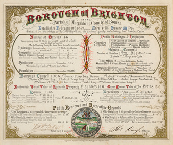
Certificate - Illuminated certificate, Hamel & Fergsuon, Brighton Municipal Certificate, 1866
bayside city council, borough of brighton, illuminated, certificate, population, rates, public buildings, mayor, town clerk, surveyor, councillors, council, borough, county of bourke, thomas crisp, cr t. crisp, census, parish of moorabbin, hamel & ferguson, coat of arms -
 Bayside Gallery - Bayside City Council Art & Heritage Collection
Map, Department of Crown Lands and Survey, Moorabbin, County of Bourke, c. 1918
The cadastral map of the Parish of Moorabbin in Victoria (L.6104) shows parish boundaries and land ownership c. 1918 when Sandringham was a Borough.moorabbin, county of bourke, map, plan, land subdivision, land titles, foreshores, sndringham, hampton, beaumaris, highett, cheltenham, department of lands and survey, land owners, cartographic material, borough of sandringham, brighton -
 Bayside Gallery - Bayside City Council Art & Heritage Collection
Map, Department of Crown Lands and Survey, Melbourne and Suburbs, City of Sandringham, 1917-1926
map, plan, foreshores, sndringham, hampton, beaumaris, cheltenham, department of lands and survey, cartographic material, borough of sandringham, moorabbin, black rock, street map, city of sandringham -
 Kew Historical Society Inc
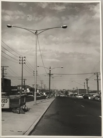
Photograph, Stuart Tompkins Studio, Electricity Supply Poles, South Road, Moorabbin, 1965
Research provided by Stuart Tompkins Studio, Box Hill, into alternatives for median strip street lighting to be used in Burke Road, Kew. The photographers identified variants in different suburbs appropriate to Kew's needs.The series from which the photograph is drawn provides a snapshot by a commercial photographic studio of each named vicinity in 1965 as well as providing examples of public works infrastructure being commissioned by local government in the 1960s. The photos originally formed part of the Engineering Department's files in the City of Kew before being donated to the kew Historical Society.Electricity Supply Poles, South Road, Moorabbin, 1965. Stuart Tompkins Studio provided this photograph for the Kew City Council. The photograph of South Road, Moorabbin, west of Jasper Road, looking east depicts steel poles with two lamps in a median strip and supply wires from pole to pole. The poles were described as 100′ apart. The notation on the rear of the photograph was that there were lamps along the median strip except at intersections. A wooden pole is recognised as supporting heavy supply lines across the road. The steel poles in the photograph were said to be between 3′ to 3.5′ whereas the wooden poles were three to 12.25″ in diameter. [There are three copies of this photograph in the Collection.] Typed inscription on reverse: "Electricity Supply Poles. Photographed for Kew City Council 8/2/65. No.2 South Road - Moorabbin, west of Jasper Road, looking east. Steel poles with two lamps in median strip and supply wires from pole to pole along median strip (poles only 100' apart). Lamps along median only except at intersections. Wooden pole supports heavy supply lines across the road. Wooden poles 3' up and 8 1/2" dia. Wooden poles 3' up and 12 1/2 dia." Studio stamp: "Stuart Tompkins Studio. 547 Station Street, Box Hill. WX1439."public infrastructure -- kew (vic.), city of kew - engineers department