Showing 486 items
matching kilometres
-
 Warrnambool and District Historical Society Inc.
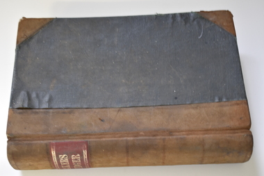
Administrative record - Bakery Ledger, Andrew Jack, Dyson & Co., Melbourne, Baker's Ledger, 1940s
This ledger comes from the Model Bakery business of G.W. Greaves, a baker and pastrycook In Allansford in the first half of the 20th century. Allansford is a township 10 kilometres east of Warrnambool, now incorporated into the City of Warrnambool. The ledger contains details of the Greaves business sales of goods, mostly bread, from 1946 to 1948 and includes the names of the customers, the orders and the moneys owing. The bakery served many nearby areas including Wangoom, Hopkins Point, Cudgee, Mepunga, Naringal and Lake Glllear. This ledger is of interest as it illustrates the size of the Allansford bakery and contains many names of people in the area in the 1940s, making it a valuable research object.This is a ledger with a black cover and leather coverings at the corners and a brown leather spine. The red label on the spine has gold lettering and ornamental edges. The inside of the cover has a red mottled pattern and has tape and string stitching. A maker's label is also inside the front cover. The pages are ruled with red lines and contain handwritten entries. There are some loose invoices. The cover is very faded and stained.Baker's Ledger Andrew Jack, Dyson & Co. Wholesale Stationersallansford bakery, greaves model bakery -
 Warrnambool and District Historical Society Inc.
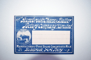
Label, Rosebrook Cheese and Butter Factory, Early 20th century
The Rosebrook Cheese and Butter Factory was opened in November 1888 by Messrs Lydiard &T F Rutledge & was a cooperative factory managed by Mr. Goldie. It operated out of the former Rosebrook Flour Mill which was built on the banks of the Moyne River near the Rosebrook bridge in the late 1840s. In 1896 the factory commenced the production of the condensation of milk. The company closed in 1911. The building and machinery were sold in 1917. Rosebrook is situated about 20 kilometres from Warrnambool on the Princes Highway. This label is of some local significance as the Rosebrook Cheese and Butter factory operated for 30 years Rectangular dark blue and white label featuring text and a trade mark. The latter is circular with three cows pictured. There are decorations of flowers and leaves. The central area of the label is white with three lines. The label is adhered to a piece of pink card.FROM THE Rosebrook Cheese & Butter Factory Company Limited, MANUFACTURERS OF "PURUS BRAND CONCENTRATED MILK Rosebrook, Port Fairy. "PURUS" TRADE MARK FOR CONCENTRATED MILKrosebrook, cheese and butter, concentrated milk, lydiard, rosebrook butter factory -
![Photograph - Digital image, Willis Vale [3], 1878c](/media/collectors/4f729f5697f83e03086015b8/items/54fd5aeb2162f10d30c0aed5/item-media/54fd5b042162f10d30c0b12d/item-fit-380x285.jpg) Greensborough Historical Society
Greensborough Historical SocietyPhotograph - Digital image, Willis Vale [3], 1878c
Ellen and Charles Partington at Willis Vale: House built by Edward Maygar, Robert Whatmough lived there mid 19th century and later sold to Partington family. It was located on the Plenty River at Partington's Flat Greensborough. Land use included farming and orchards. The derelict Willis Vale house was destroyed in 1964 when a fire originating from North Plenty Gorge - Kurrak Road - was lit by two teenage boys and made its way several kilometres down to Partington's Flat Greensborough.Home of the Partington familyDigital copy of black and white photograph.charles partington, willis vale, ellen partington -
 Warrnambool and District Historical Society Inc.
Note Book, Engineering Drawings, 1919-21
This note book contains handwritten material by Ron Uebergang – notes on engineering drawings prepared for a class at Warrnambool Technical School 1919-1921. Ronald Uebergang (1903-1971) was the son of Ernest and Mary Uebergang. He attended Allansford State School and Warrnambool Technical School and spent his working life dairying and raising cattle on the family property, Hopkins Hill, at Allansford, about nine kilometres east of Warrnambool. He was mechanically minded, fond of music and dancing and a keen photographer. These notes are of interest as they were compiled by Ron Uebergang when he was a student at Warrnambool Technical School 1919-21. The Uebergang families were pioneering settlers in the Allansford area and have been prominent farmers in the area from the 1850s on. The notes also are a good example of the work done by students at Warrnambool Technical School in the 1920s. This is a hand-made book of 22 pages with notes on engineering drawings by Ron Uebergang handwritten in black ink. There is tissue paper inserted between some of the pages. There are several drawings and equations in with the handwritten material. There is some silver fish damage on the front cover. Front Cover: ‘R. Uebergang’ ‘Note Book for Engineering Drawing Grade 3’ ronald uebergang, warrnambool technical school, history of allansford, history of warrnambool -
 Warrnambool and District Historical Society Inc.
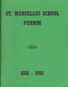
Book, St Marcellus School 1886-1986, 1986
History of St. Marcellus School, PurnimThis is a soft-cover book with a green cover and 112 pages. There are printed historical writings, copies of photographs and certificates, extracts from other books and advertisements. The title on the front cover is printed in black.non-fictionHistory of St. Marcellus School, Purnimpurnim, catholic schools, warrnambool, st. marcellus school -
 Ambulance Victoria Museum
Ambulance, Motorcycle, Paramedic, Gilera 100, Circa 2006
A very small number of these Gilera 100 three wheeled motorcycles were purchased by Ambulance Victoria so that paramedics could negotiate traffic in built up areas and attend patients more quickly. Unfortunately, the paramedics using these vehicles did not feel they were safe to drive and they were soon withdrawn from service and replaced by conventional BWM motorcycles. This vehicle has only around 4500 kilometres usage on its speedometer. Source Chas Martin curator AHSVMotorcycle with twin front wheels.1E-SUD 7362paramedic, gilera -
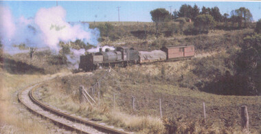 Otway Districts Historical Society
Photograph, R.K. Whitehead, G42 between Beech Forest and Ferguson, 1960, July 1960
By July 1960 for the Beech Forest railway outwards traffic was down to 12,730 tonnes per year, and from Ferguson under 1,000 tonnes per year. One wagon was all that was needed in July to reach Beech Forest The line kilometre proportion of $26,320 was sufficient in itself to justify the withdrawal of the rail service, without the fact that reconditioning the two Garratt locomotives and rendering serviceable the ancient wagons would make the costs prohibitive. As a result the whole line closed in June 1962.Colour. 144mm x 279mm. G42 locomotive with Weeaproinah goods in a loaded NQR wagon and NC guard's van, between Beech Forest and Ferguson in July 1960.ferguson: beech forest; railways; -
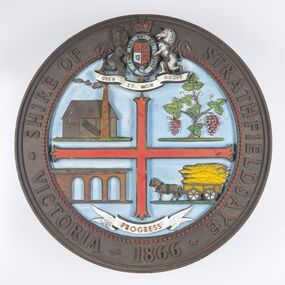 City of Greater Bendigo - Civic Collection
Sign - Shire of Strathfieldsaye Coat of Arms
The district of Strathfieldsaye was proclaimed in 1861 and named a Shire on the 17th September in 1866. It remained a shire until amalgamation in 1994 when it became part of the City of Greater Bendigo. The shire was located 8 km to the south- east of Bendigo and covered an area of 601 square kilometres and extended from the Calder Highway to the Coliban and Campaspe Rivers. The shire's administration centre was in Strathfieldsaye until 1972 when new offices were opened in Kennington. This coat of arms was commissioned for the front of the shire hall building.Brass painted coat of arms or emblem within a circle of the Shire of Strathfieldsaye. Outer rim contains text: SHIRE OF STRATHFIELDSAYE VICTORIA 1866 with the shield of the monarch of the United Kingdom centre top. The shield is divided into four parts with images reflecting the leading industries of the time; wine growing, mining, farming and tanning. The motto PROGRESS is depicted lower centre of shield. SHIRE OF STRATHFIELDSAYE / VICTORIA / 1866 / PROGRESSshire of strathfieldsaye, city of greater bendigo amalgamation, city of greater bendigo signs -
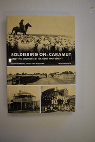 Warrnambool and District Historical Society Inc.
Book, StarPrinting Service Pty ltd, Soldiering On – Caramut and the Soldier Settler Movement, 2018
This book records the history of the post World War Two soldier settlement farms in the Caramut area. Number two in a series of books on Soldier Settlements in Western Victoria.This is a soft cover book of 315 pages. It has a buff-coloured cover with black and white photographs and white printing on the front cover and black printing on the spine. The book includes printed material, black and white photographs, maps and plans. non-fiction This book records the history of the post World War Two soldier settlement farms in the Caramut area. Number two in a series of books on Soldier Settlements in Western Victoria.james affleck, peterborough, soldier settlement, caramut, history of warrnambool, soldier settlement, caramut -
 Federation University Historical Collection
Booklet, GIAE Official Opening, 1976, 11/1976
The Gippsland Institute of Advanced Education was established by an Order-in-Council in September 1968. On its establishment, the Institute assumed responsibility for the diploma coursed previously offered at Yallourn Technical College. In 1972 the Institute transferred part of its operations to the first of its permanent buildings on a large campus in rural surrounding near the township of Churchill, ten kilometres south of Morwell, and 160 kilometres east of Melbourne. The campus site plan report prepared in 1970 by the Institute's campus planners, Yuncken Freeman Architects Pty Ltd, provided the conceptual base for the development of a new campus at Churchill. All facilities were planned to converge on a central space; all having the ability to expand outwards. Central to the campus plan was the concept of an internal pedestrian street connecting all academic divisions to the central facilities. The first building was completed in 1972. The Administration Building, Visual Art & Maintenance Workshops, Multi-Purpose Building, and Student residences were designed by Yuncken Freeman Architects. The central Facilities Building (cafeteria and Union) were designed by Chancellor and Patrick, the Education Building and Applied Science Building is designed by Eggleston, McDonald and Secomb.Grey and yellow soft covered booklet prepared for the official opening of Gippsland Institute of Advanced Education.gippsland institute of advanced education, gippsland campus, churchill, m.w. hopper, c.h. ford, lindsay thompson, j.l. carrick, r.w. muncey -
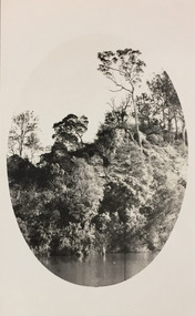 Kew Historical Society Inc
Photograph - Tambo River, 1926
Henry Beater Christian (1886-1962) , was a descendant of one of the earliest settler families in Kew. Employed at the Kew Asylum as a 'public servant', he was a skilled amateur photographer, photographing numerous scenes in Kew and on his travels around Victoria. The majority of his photographs date from 1916 to 1929. His finest photographs are housed in two photograph albums. Digital copy of a photograph from page 31 of the 47-page photograph album containing 261 gelatinous silver images, loaned by Diane Washfold with permission given to digitise and hold a copy in our collection. John Chapman has written in 'Bushwalking Clubs - A Brief History', about the establishment in Victoria of the first bushwalking club in 1888, and the popularisation of bushwalking during the interwar period. Henry Christian's 'walks' appear to have been undertaken solely or with a companion/s. This black and white photo is part of a group of six photos taken on an 18 kilometre walking trip between Bruthen and Swan Reach in East Gippsland in 1926. The route of the walk followed the Tambo River. The photographer has focussed the view using an oval frame during the development process."BRUTHEN TO SWAN REACH 1926"henry beater christian (1886-1962), landscape photography, christian-washfold collection, photograph albums, bushwalking, bruthen, swan reach, tambo river, east gippsland -
 Kew Historical Society Inc
Photograph - Small creek between Bruthen and Swan Reach, 1926
Henry Beater Christian (1886-1962) , was a descendant of one of the earliest settler families in Kew. Employed at the Kew Asylum as a 'public servant', he was a skilled amateur photographer, photographing numerous scenes in Kew and on his travels around Victoria. The majority of his photographs date from 1916 to 1929. His finest photographs are housed in two photograph albums. Digital copy of a photograph from page 31 of the 47-page photograph album containing 261 gelatinous silver images, loaned by Diane Washfold with permission given to digitise and hold a copy in our collection. John Chapman has written in 'Bushwalking Clubs - A Brief History', about the establishment in Victoria of the first bushwalking club in 1888, and the popularisation of bushwalking during the interwar period. Henry Christian's 'walks' appear to have been undertaken solely or with a companion/s. This black and white photo is part of a group of six photos taken on an 18 kilometre walking trip between Bruthen and Swan Reach in East Gippsland in 1926. The route of the walk followed the Tambo River. The photographer has focussed the view on a small creek between the two towns."BRUTHEN TO SWAN REACH 1926"henry beater christian (1886-1962), landscape photography, christian-washfold collection, photograph albums, bushwalking, bruthen, swan reach, tambo river, east gippsland -
 Kew Historical Society Inc
Photograph - Farmland, near or between Bruthen and Swan Reach, 1926
Henry Beater Christian (1886-1962) , was a descendant of one of the earliest settler families in Kew. Employed at the Kew Asylum as a 'public servant', he was a skilled amateur photographer, photographing numerous scenes in Kew and on his travels around Victoria. The majority of his photographs date from 1916 to 1929. His finest photographs are housed in two photograph albums. Digital copy of a photograph from page 31 of the 47-page photograph album containing 261 gelatinous silver images, loaned by Diane Washfold with permission given to digitise and hold a copy in our collection. John Chapman has written in 'Bushwalking Clubs - A Brief History', about the establishment in Victoria of the first bushwalking club in 1888, and the popularisation of bushwalking during the interwar period. Henry Christian's 'walks' appear to have been undertaken solely or with a companion/s. This black and white photo is part of a group of six photos taken on an 18 kilometre walking trip between Bruthen and Swan Reach in East Gippsland in 1926. The route of the walk followed the Tambo River. The photographer focusses the camera view on distant farmland near or between either of the two towns."BRUTHEN TO SWAN REACH 1926"henry beater christian (1886-1962), landscape photography, christian-washfold collection, photograph albums, bushwalking, bruthen, swan reach, tambo river, east gippsland -
 Melbourne Tram Museum
Slide - Set of 7, Len Millar, 18/04/1974 12:00:00 AM
Set of seven Kodak white cardboard 35mm colour slides by Len Millar of the move of former VR tram No. 34 from Yarrambat to the TMSV site at Bylands on 18/4/1974. Reference June 1974 issue of Trolley Wire. Note the Brill 77E trucks i the background were obtained at the same time. These would have been 5'3" gauge and it would appear that the tram was placed on a set of MMTB No. 1 trucks. Len Millar advised 21-7-2021 - that Trolley Wire says that the tram was obtained from a private property on the banks of thee Plenty River at Yarrambat, It was perched on a steep slope only 50 metres from the house, but two kilometres in from the nearest road. The track out to the nearest road was steep, rough and akin to a “goats’ track”!trams, tramways, vr trams, recovery, transporting trams, tmsv, bylands, tram 34 -
 Orbost & District Historical Society
albums, late 1980's
These two albums were used at the Slab Hut - Orbost Visitor Information Centre. The Orbost Visitor Information Centre is situated in Forest Park on Nicholson Street. The centre is housed in the historic Slab Hut. The hut was an original family dwelling built in 1872, on a site approximately three kilometres upstream from the junction of the Buchan and Snowy Rivers. No nails were used in the construction; it was all wired together. After a period in storage the slab hut was opened in its present location in Orbost as the Information Centre in 1987.These albums are contemporary records of the construction and relocation of an iconic Orbost building, the Slab Hut.Two large photo albums. 2280.1 has no front cover. The back cover and spine are red. The pages are black and most photos are labelled. They are photographs of the Orbost area. 2280.2 has brown covers. It contains photographs of the construction of the gardens and buildings around the Slab Hut (Orbost Visitor Information Centre). On the cover in gold print is "PHOTOS".slab-hut-orbost album-photographs-orbost -
 Warrnambool and District Historical Society Inc.
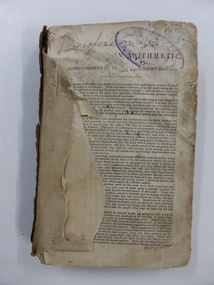
Book, Arithmetic, 1842
This is an early school arithmetic book with the front preface indicating it is the third edition published in 1842. The book appears to have been used about the 1860s by members of the Bell family who probably lived at Cudgee. The names of the children, presumably the Bell children, are scattered throughout the book – Margaret, Walter, Sarah and William. No information is available on this Bell family though there are records of births in Warrnambool of Bell children in the 1850s to William and Jane Bell. Cudgee, a small settlement on the Cudgee Creek, is about 16 kilometres from Warrnambool. This book is of some minor interest because of its age and because it has some association with the Bell family who may have lived at Cudgee in the mid 19th century. The exercises in the book are of interest as examples of the arithmetical problems given to children in the mid 19th century. This is a hard cover book of 282 pages. The cover is dark brown with gold lettering on the spine but the front cover and part of the first few pages are missing. The pages are ragged and dog-eared and quite dirty in places. There is handwritten material in both pencil and ink on the front pages, throughout the text and on the back page. ‘Margaret’ ‘Walter’ ‘Sarah’ ‘William Bell’ ‘Cudgee’ mathematics, bell family, cudgee, warrnambool history -
 Warrnambool and District Historical Society Inc.
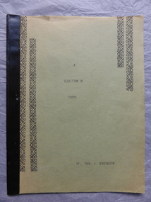
Book, A section of Poems, Mid 1930s
This booklet of poems has been compiled by Thomas Terrington. Born in 1897 Tom Terrington worked at dairying, fencing, carpentering and woodcutting before taking over the Framlingham store when he was in his forties. He was a scholarly person with a wide knowledge of English literature. He was a well-known local poet and a member of the Australian Poetry Lovers’ Society. He wrote extensively on local history and his unpublished ‘History of Framlingham’ is in the State Library. Framlingham is a small settlement 25 kilometres north east of Warrnambool. This booklet is of interest as it contains some of the poems written by Tom Terrington, an important resident of Framlingham in the 20th century. This is a soft cover book of 24 pages. The cover is green with black decorative borders and black binding. The pages have black printing on green paper. The last few pages are missing. The cover is faded and a little torn. There are ornamental scrolls and patterns in black throughout the pages. tom terrington, history of framlingham -
 Warrnambool and District Historical Society Inc.
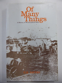
Book, Of Many Things, 1987
This book is the official history of the Shire of Warrnambool from 1863 to 1987. It was written by C.E. Sayers for the Shire of Warrnambool. Sayers also wrote the history of Warrnambool called By These We Flourish for the Warrnambool City Council. The Shire of Warrnambool was established in 1863 and the first meeting was held in January 1864. In 1992 the Shire covered an area of 1605 square kilometres and had a population of 8,940 and included the areas around Koroit, Allansford, Peterborough, Port Fairy and Nirranda. The Shire of Warrnambool was abolished in 1994 and was incorporated with other municipalities into the Shire of Moyne. This book is the official history of the Shire of Warrnambool and this copy is kept for future reference when the book is superseded or out of print. This is a hard cover book of 196 pages. It has a brown cover with gold lettering on the spine. The dust cover has a white background with an image on the front cover in brown and grey tonings of a rural property in the Shire of Warrnambool. The lettering on the dust cover is orange on the front cover and black on the spine. The book has a foreword, an introduction, 14 chapters of text, appendices and an index. There are many black and white photographs.shire of warrnambool, history of warrnambool, of many things -
 Warrnambool and District Historical Society Inc.
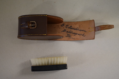
Clothes brush & holder, Mid 20th century
The brush in this case could have been used as a hair brush or a clothes brush. It is enclosed in a leather case and was probably an item made for travellers. The brush and case belonged to George Tomlinson of Ballangeich. Ballangeich is a small settlement on the Hopkins Highway about 27 kilometres from Warrambool. George Tomlinson’s grandfather, William Tomlinson , established a farming property at Ballangeich in 1865 and opened a hotel, ‘Half Way House’ on part of the land. George Tomlinson’s father, also William, continued to farm in the area and was known as a fine judge of cattle and sheep. This case and brush are of interest as an example of the brushes men used in the mid 20th century. The items are also of interest as they belonged to a member of a well-known Ballangeich family (Tomlinsons).1 This is a piece of brown leather rolled over and stitched with yellow thread to form a container or case. The case has a closing mechanism – a leather strap and metal buckle. .2 Inside the leather case is a brush with a brown Bakelite back with horsehair inserted. ‘G.E. Tomlinson Ballangeich Victoria’men’s toiletries, ballangeich, history of warrnambool -
 Greensborough Historical Society
Painting - Digital image, Barn at Willis Vale, 1920c
Painting of a barn at Willis Vale. 'Willis Vale' was owned and farmed by the Partington family from the 1870s. The derelict Willis Vale house was destroyed in 1964 when a fire originating from North Plenty Gorge - Kurrak Road - was lit by two teenage boys and made its way several kilometres down to Partington's Flat Greensborough. Gary Partington thought the barn was probably associated with the bull yard. (Note: Only some abandoned stumps existed when Gary was very young in the mid to late 1940s) Digital copy of painting.willis vale, partington family -
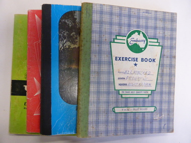 Warrnambool and District Historical Society Inc.
Booklet, Allansford Progress Association, Second half of 20th century
These four exercise books give documentation on the activities of the Allansford Progress Association (1966 to 1988). Allansford is a settlement about 9 kilometres from Warrnambool and most of the town area is now within the boundaries of the Warrnambool City Council. The association was re-formed in November 1966 after the demise of an earlier group. The members of the group campaigned in areas of local concern – T. V. reception, drainage and sewerage, postal services, sports facilities including the development of the Speedway, housing development, road proposals, waste management and disaster plans. These books are of interest in that they provide an overview of the history of a local organization. They will be useful for research. These are four exercise books - three Minutes books, and one Accounts book, from the Allansford Progress Association (1966-1988). The exercise books have coloured covers, (blue and white checkered, green, red and blue). Two are bound with tape and two are stapled. There are some loose sheets in all of the books. All the entries are handwritten. On front covers: ‘Allansford Progress Association’allansford progress association, history of allansford, history of warrnambool -
 Orbost & District Historical Society
black and white photograph, February 1971
This photograph was taken near the Snowy River Bridge on the the old Princes Highway in Orbost, near the caravan park. The 1971 flood was the the worst flood on record. At Jarrahmond it was at least 11 metres and up to one and a half kilometres wide on the flats causing enormous damage to the flood plain. Records say that "The brown floodwater stain in Bass Strait could be seen from passing airliners." Considerable damage was done to railway infrastructure, roads and farms. More information from the APRIL, 2008 newsletter by John Phillips. (see orbosthistory.com.au)This is pictorial evidence of a significant local event. Floods have been an integral part of Orbost's history for hundreds of years.A black / white photograph of debris, fallen power lines, a tree across the highway and floodwaters across the road.on front at bottom - handwritten in upper case print - " 1971 FLOOD PRINCES HIGHWAY NEAR SNOWY BRIDGE"floods-orbost-1971 -
 Orbost & District Historical Society
black and white photograph, February 1971
This photograph is an aerial view of the township of Orbost taken by the Bairnsdale Advertiser newspaper. It was taken from the northern end of the town. The 1971 flood was the the worst flood on record. At Jarrahmond it was at least 11 metres and up to one and a half kilometres wide on the flats causing enormous damage to the flood plain. Records say that "The brown floodwater stain in Bass Strait could be seen from passing airliners." Considerable damage was done to railway infrastructure, roads and farms. More information from the APRIL, 2008 newsletter by John Phillips. (see orbosthistory.com.au)This is a pictorial record of a significant event in the history of Orbost,A black / white aerial photograph of a township with floodwaters in the background.on back - "Note main current through the lagoon 1971."orbost-floods-1971 bairnsdale-advertiser orbost-township -
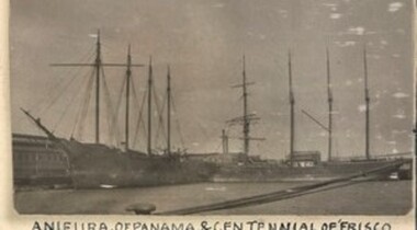 Queenscliffe Maritime Museum
Furniture - Bunk, sailor's, 1918 - 1928
Anieura. Four-masted wooden schooner, 1328 tons. Built California, 1918 as the Oronite. Reg. Melbourne, 1928. Lbd 236.5 x 42 x 29. Last captain, de Carteret. Stripped of anything of value at the Yarra Street Pier, Geelong, in 1932; burnt to recover her copper and brass, and sunk off Avalon Bach, two kilometres east of Point Lillias. She had been seized for debt. @ Her wreckage is scattered and overgrown, covered in light silt in 4 metres. [NWR],[LC],[NSC]A relic from the broken up Barque 'Anieura' in 1932/33: BARQUE ANIEURA. Left to Sink in Mud. GEELONG Monday -The hulk of the barque Anieura, which has been idle in Corio Bay for more than four years, was towed to a spot near Bird Rock on the northern shores of the outer harbour on Monday. The Anieura was built for the timber trade and made a journey to Australia. The owners then decided that the vessel was unsuitable for this trade, and she was sold to an Australian firm. The ship was placed in Corio Bay, and remained at anchorage for about three years before an effort was made to sell her. This being unsuccessful most of the fittings, were disposed of, and the hulk was taken to Fletcher's pier to be out of the way of shipping. The Victorian Salvage Co's offer to the Geelong Harbor Trust to dispose of the hulk was accepted. The 300 tons of road metal ballast was removed, and a quantity of timber taken out. The vessel was towed through the channel this morning and run aground near Bird Rock just outside of the north-east extremity of the bar where it is away from shipping. More timbers will be stripped from the vessel, and it is likely that she will be allowed to sink into the mud. The Argus Tuesday 4 April 1933. A wooden bunk from the 'Anieura', drawers underneath with brass handlesanieura, bunk, port phillip -
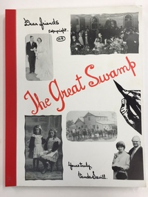 Warrnambool and District Historical Society Inc.
Book, The Great Swamp, 1980s
This book has been written by Vanda Savill and is about the settlers in the Wallacedale area in Western Victoria. Wallacedale is 28 kilometres south west of Hamilton and was created by the draining of the Condah Swamp. Vanda Savill (1913-2005) and her husband ran a dairy farm and the Bower Birds Nest Museum and History Centre at Heywood. Vanda Savill was passionate about keeping alive the personal histories of local people and for 20 years she wrote and published many books about the areas in which she lived. This book is of interest because it tells the stories of settlers in the Wallacedale area of Western Victoria. It also has appeal because of the warm, conversational style of the author.This is a soft cover book of 216 pages. The cover has a white background with a black and white image of a hand holding a pen and, on the front cover, five black and white photographs and, on the back cover, nine black and white photographs. The title of the book is in red cursive writing. The information in the book is printed from the original handwriting of the author (Vanda Savill). The book also has many black and white photographs. The book is bound with red tape.wallacedale, history of western victoria, vanda savill, warrnambool -
 Kiewa Valley Historical Society
Photograph - Mt Bogong - Tawonga, 06/05/1937
Mount Bogong located in the Alpine National Park and part of the Victorian Alps of the Great Dividing Range, is the highest mountain in Victoria, Australia, at 1,986 metres (6,516 ft) above sea level. The Big River separates the massif of the mountain from the Bogong High Plains to the south. From the nearby town of Mount Beauty to its summit, Mount Bogong rises more than 1,600 metres (5,200 ft), thus making it one of the highest peaks in Australia not only in terms of its elevation above sea level, but also in terms of actual base-to-summit prominence. Mount Bogong is a popular backcountry skiing mountain through winter but only has snow for the mid winter-spring months. It is around 30 kilometres (19 mi) by road and walking track or 12 kilometres (7.5 mi) direct to Mount Beauty. Falls Creek and Mount Hotham ski resorts are also nearby. Camping is relatively safe below the tree line but the summit ridgeline is very exposed. Emergency shelter is also available at Bivouac Hut on the Staircase Spur, and at Cleve Cole, above Camp Creek on the broad ridge to the south of the summit, and Michells Hut on the Eskdale Spur. Mt Bogong is a popular recreational venue in the Kiewa Valley for back country skiing and bush walking and is a favourite with sightseers and popular subject for photographersBlack and white photograph of Mt bogong taken from Tawonga - Thursday May 6th, 1937Handwritten on back of photograph. Thursday May 6th, 1937. Mt Bogong Tawongamt bogong, tawonga, kiewa valley -
 Orbost & District Historical Society
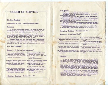
program, 1936
This service was held on January 28, 1936 at the Mechanics' Institute, Orbost. Born in 1865, George V was the second eldest son of Edward VII and Alexandra 1865. He first visited Australia with his elder brother Prince Albert as midshipmen aboard the HMS Bacchante in 1880. He was King of the United Kingdom and the British Dominions, and Emperor of India, from 6 May 1910 until his death in 1936. The Shire of Orbost was a local government area about 380 kilometres east of Melbourne. The shire covered an area of 9,347 square kilometres and existed from 1892 until 1994. Originally, Orbost was part of the Bairnsdale Road District which was created on 30 April 1867. Splitting away as part of the Shire of Tambo in 1882, Orbost was first incorporated as a shire in its own right as the Shire of Croajingolong on 30 May 1892. It received its present name on 17 February 1893. On 3 January 1913 part of its western riding was annexed to Tambo as its Cunninghame Riding. On 2 December 1994, the Shire was abolished, and merged with City and Shire of Bairnsdale, Shire of Tambo, most of the Shire of Omeo and the Boole Boole Peninsula from Shire of Rosedale into the Shire of East Gippsland.This item reflects the significance of monarchy for Australia and the constitutional history of Australia.The item reflects the interest in the royal family to Australians at this time as well as the general feeling of respect and admiration felt by the rural communities towards the British Royal Family..A folding single sheet, white paper program with a dark purple print. It is a program for the Orbost Shire Council memorial service for the death of King George V. On the front is "Shire of Orbost Memorial Service for his late Majesty King George V". Details of the time and venue are below. This print is inside a rectangular border. On the back of the program are the words of the national anthem, Kipling's "Recessional" and a prayer. Inside is the order of the service.royalty george-v-death-memorial orbost-shire-council -
 Orbost & District Historical Society
black and white photograph, February, 1971
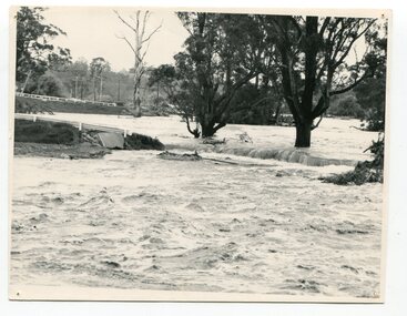
This photograph shows the floodwaters during the 1971 flood at Orbost. The two mahogany trees in the photograph stopped the Snowy River from changing its course. The 1971 flood was the the worst flood on record. At Jarrahmond it was at least 11 metres and up to one and a half kilometres wide on the flats causing enormous damage to the flood plain. Records say that "The brown floodwater stain in Bass Strait could be seen from passing airliners." Considerable damage was done to railway infrastructure, roads and farms. More information from the APRIL, 2008 newsletter by John Phillips. (see orbosthistory.com.au)This is a pictorial record of a significant event in the history of floods in Orbost.A black / white photograph of raging floodwaters at the bottom of the Orbost township.orbost-flood-1971 -
 Orbost & District Historical Society
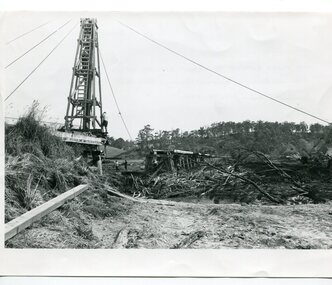
black and white photographs, 15th February 1971
The 1971 flood was the the worst flood on record. At Jarrahmond it was at least 11 metres and up to one and a half kilometres wide on the flats causing enormous damage to the flood plain. Records say that "The brown floodwater stain in Bass Strait could be seen from passing airliners." Considerable damage was done to railway infrastructure, roads and farms. More information from the APRIL, 2008 newsletter by John Phillips. (see orbosthistory.com.au) The railway line was destroyed and was not expected to be opened for a fortnight. Orbost was cut off by 50 square miles of Snowy River floodwater. These photographs are pictorial records of the 1971 floods which was a significant event in the history of Orbost. They are also associated with the East Gippsland Railway.Three black / white photographs of flood debris and flood waters near a railway line. 3102.l has a pile driver 3102.2 shows a gap in the viaduct and 3102.3 shows men with a tractor cleaning up the debris,3102.1 - on back - "1971 FLOOD REPAIRS TO ORBOST RAILWAY VIADUCT - 15th February 1971. Donated by Audrey Van Den Berg VRH 3693" 3102.2 - on back - " DAMAGE TO RAILWAY VIADUCT ACCUMULATED DEBRIS" 3102.3 - on back - "DAMAGE TO RAILWAY VIADUCT AT ORBOST. CLEAN UP BEGINS"orbost-flood-1971 orbost-viaduct-flood-damage orbost-railway -
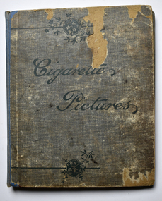 Warrnambool and District Historical Society Inc.
Album - Album with Cigarette Cards, Edwards Family, Cigarettes Pictures, 1908
This album contains cigarette cards dating from the early 20th Century. The cards include Australian and English cricketers, Australian footballers, animals, racehorses, ships, Pacific Islanders, jockeys, actors and other famous people. The cards come from a variety of Australian and English cigarette companies. The album comes from the Edwards family who lived on the MORVEN property situated about 11 kilometres west of Branxholme in the Western District of Victoria. This property was sub divided in 1911 into 25 farms. There was once a Morven School and today there is a road of that name in the area.. This album is of considerable significance as it has historical value as an early collection of cigarette cards. Collecting of cigarette cards was a major social activity amongst young people, particularly in the first half of the 20th Century. It was a profitable advertising ploy for cigarette companies. Card and small object collecting by children today is still popular and used as an advertising mechanism. This album has a worn cover in faded green and fawn colours with a blue spine almost wholly detached. The back cover is stained. The cover has text. There are eighteen double sided pages with cut spaces for holding seven cigarette cards on each. Most of the pages contain black and white, sepia or coloured cigarette cards. There is an inscription on the first page.To Bennie from Auntie Lou. Xmas 1908cigarette cards, morven, edwards family morven, album