Showing 15539 items matching "glengarry history | gippsland"
-
 Orbost & District Historical Society
books, 1938 - 1980
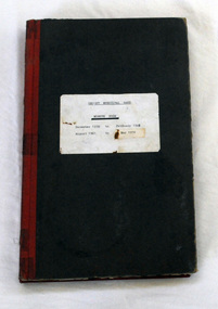
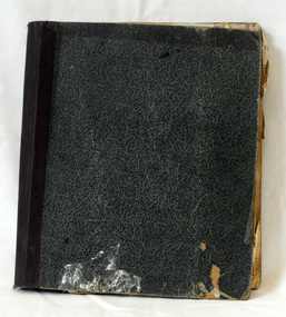
... Orbost, East Gippsland, Victoria, Australia...Orbost & District Historical Society Ruskin Street Orbost gippsland The Orbost Workers' Band and the Orbost Town Band amalgamated in 1913 to form the Orbost Municipal Band under the conductorship of Mr Charles Spink. ...The Orbost Workers' Band and the Orbost Town Band amalgamated in 1913 to form the Orbost Municipal Band under the conductorship of Mr Charles Spink. The Orbost Municipal Band played a major role in the Orbost community activities. Charles Spink made sure each soldier returning home from the 1914 to 1918 war was welcomed home in front of the Shire Hall to the music of the Orbost Municipal Band. The band played in the main street on most Friday nights and in 1929 the band played at the official opening of the Buchan Caves, by Sir Albert Lind. The various Orbost bands over the years played a major role in community activities providing entertainment and musical experiences for the many members.Two hard back minute books with black covers and red spines. There is a white paper label with details of dates and the title "ORBOST MUNICIPAL BAND MINUTE BOOK".orbost-municipal-band -
 Orbost & District Historical Society
correspondence books, 1963 - 1979
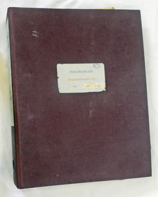
... Orbost, East Gippsland, Victoria, Australia...Orbost & District Historical Society Ruskin Street Orbost gippsland Orbost Town Band amalgamated in 1913 to form the Orbost Municipal Band under the conductorship of Mr Charles Spink. ...Orbost Town Band amalgamated in 1913 to form the Orbost Municipal Band under the conductorship of Mr Charles Spink. The Orbost Municipal Band played a major role in the Orbost community activities. Charles Spink made sure each soldier returning home from the 1914 to 1918 war was welcomed home in front of the Shire Hall to the music of the Orbost Municipal Band. The band played in the main street on most Friday nights. The various Orbost bands over the years played a major role in community activities providing entertainment and musical experiences for the many members.Three A4 folders containing inward correspondence related to the Orbost Municipal Band. 802.1 has a maroon cover and is dated from 1963 -1977. 802.2 has a grey cover and is dated from 1978 - 1979. 802.3 has a grey cover and is dated 1974 - 1975 .orbost-municipal-band -
 Orbost & District Historical Society
correspondence books, 1965 - 1979
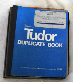
... Orbost, East Gippsland, Victoria, Australia...Orbost & District Historical Society Ruskin Street Orbost gippsland Orbost Town Band amalgamated in 1913 to form the Orbost Municipal Band under the conductorship of Mr Charles Spink. ...Orbost Town Band amalgamated in 1913 to form the Orbost Municipal Band under the conductorship of Mr Charles Spink. The Orbost Municipal Orbost Band played a major role in the Orbost community activities. Charles Spink made sure each soldier returning home from the 1914 to 1918 war was welcomed home in front of the Shire Hall to the music of the Orbost Municipal Band. The band played in the main street on most Friday nights. The various Orbost bands over the years played a major role in community activities providing entertainment and musical experiences for the many members.Five correspondence books with carbon pages. They contain outward correspondence related to the Orbost Municipal Band. 803.1 is dated March 1962 - May 1965. 803.2 is dated September 1972 - May 1974. 803.3 is dated February 1973 - July 1975. 803.4 is dated august 1975 - March 1977. 803.5 is dated March 1977 - 79. The books are "TUDOR DUPLICATE BOOK"s with blue covers and white print.labels on front covers with datesorbost-municipal-band -
 Orbost & District Historical Society
documents in vinyl case, 1963 1977
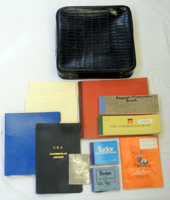
... Orbost, East Gippsland, Victoria, Australia...Orbost & District Historical Society Ruskin Street Orbost gippsland Orbost Town Band amalgamated in 1913 to form the Orbost Municipal Band under the conductorship of Mr Charles Spink. ...Orbost Town Band amalgamated in 1913 to form the Orbost Municipal Band under the conductorship of Mr Charles Spink. The Orbost Municipal Band played a major role in the Orbost community activities. Charles Spink made sure each soldier returning home from the 1914 to 1918 war was welcomed home in front of the Shire Hall to the music of the Orbost Municipal Band. The band played in the main street on most Friday nights. an The various Orbost bands over the years played a major role in community activities providing entertainment and musical experiences for the many members. A black vinyl case with a carry handle. It contains documents relating to the Orbost Municipal Band - financial reports in ledgers and exercise books; cheque books and deposit books from the Commonwealth Bank; receipt books; invoices; receipts; submissions; quotes; and five cheque book stubs.labelled Orbost Municipal Bandorbost-municipal-band accounts book-keeping -
 Orbost & District Historical Society
book, 1936
... Orbost, East Gippsland, Victoria, Australia...Orbost & District Historical Society Ruskin Street Orbost gippsland This book was used byb the Orbost branch of M.U.I.O.O.F. ...This book was used byb the Orbost branch of M.U.I.O.O.F. (Manchester Unity Order of Oddfellows)Friendly Societies were founded in the Australian Colonies in the mid-19th Century by immigrants from England who had been members in Societies which dated back to the 18th Century. Like all working people these immigrants experienced sickness, accidents, unemployment, death and burial. They needed help of like fellows to tide their families over these times. So they formed a branch of one of the Friendly Societies back in the mother country. The idea was to make fixed contributions to a fund and when they were off work they would receive a payment. When they died funeral benefits would be paid and the widow and children would be cared for. It was a form of local insurance for hard times. This was a time of 'look after yourself' as the Colonial Governments did not provide pensions or benefits. This item reflects those times.A hard back book with a green / blue mottled cover with a brown binding. It includes a receipt book with no cover. It holds M.I.U.O.O.F. (Manchester Unity Order of Oddfellows) accounts.friendly-society m.u.i.o.o.f. accounts -
 Orbost & District Historical Society
minute book, 1886
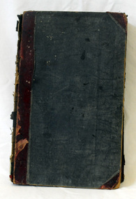
... Orbost, East Gippsland, Victoria, Australia...Orbost & District Historical Society Ruskin Street Orbost gippsland This minute book was used by the Orbost branch of M.U.I.O.O.F. ...This minute book was used by the Orbost branch of M.U.I.O.O.F. (Manchester Unity Order of Oddfellows)Friendly Societies were founded in the Australian Colonies in the mid-19th Century by immigrants from England who had been members in Societies which dated back to the 18th Century. Like all working people these immigrants experienced sickness, accidents, unemployment, death and burial. They needed help of like fellows to tide their families over these times. So they formed a branch of one of the Friendly Societies back in the mother country. The idea was to make fixed contributions to a fund and when they were off work they would receive a payment. When they died funeral benefits would be paid and the widow and children would be cared for. It was a form of local insurance for hard times. This was a time of 'look after yourself' as the Colonial Governments did not provide pensions or benefits. This item reflects those times.A large thick hard back minute book used by M.U.I.O.O.F. ( Manchester Unity Order of Oddfellows). It has a blue cover with a red spine. -
 Orbost & District Historical Society
photograph, C 1950
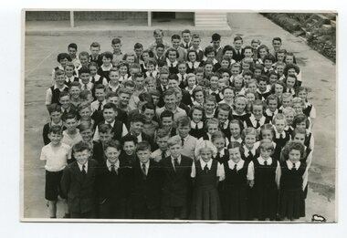
... Orbost, East Gippsland, Victoria, Australia...Orbost & District Historical Society Ruskin Street Orbost gippsland The Herald was a broadsheet newspaper published in Melbourne, Australia from 1840 to 1990.This photo is a copy of a photograph taken by the Herald for publication. ...The Herald was a broadsheet newspaper published in Melbourne, Australia from 1840 to 1990.This photo is a copy of a photograph taken by the Herald for publication.Orbost High School / Orbost Secondary College has played a significant part in the education of senior students in the Orbost district . It is the sole senior educational institution. This photograph is representative of its history.A black / white photograph of a group of students, most in uniform, standing in the quadrangle of the Orbost High School.on back - " Copyright, not for reproduction, Herald Feature Service, Melbourne, Australia".orbost-high-school herald-melbourne -
 Orbost & District Historical Society
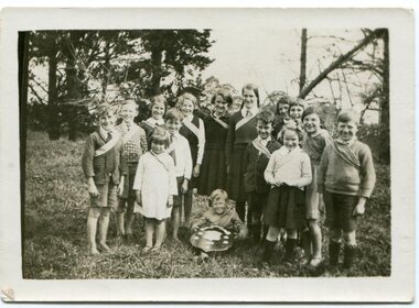
photograph, 1937
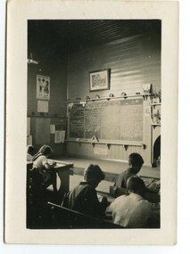
... Bete Bolong, East Gippsland, Victoria, Australia...Orbost & District Historical Society Ruskin Street Orbost gippsland In 1912 the school at Pumpkin Point opened to serve the children of farmers living in the Bete Bolong district. ...In 1912 the school at Pumpkin Point opened to serve the children of farmers living in the Bete Bolong district. This meant a big change in their way of life because in the past the children had been rowed across the Snowy River each day to attend school at Jarrahmond. Myrtle Bunting was the first HT of the school which had been erected on a block of land purchased from H. Richardson. The school functioned until 1952 when a shortage of pupils caused its closure. As a bus service to Orbost now operated, the school at Pumpkin Point faced permanent closure. J. McKeown bought the building. Students attending the school at this time included Russells, Johnstones, Reeves, Healeys, Kavanaghs, Phillips, Rodwells, Mills, Baileys, Gilberts and Masons. Mr. Oswald S. Green taught at Bete Bolong State School until he was appointed to Rokewood Junction in August 1937.This item is associated with the history of education in the Orbost district. There is no longer a school at Bete Bolong.A small black / white photograph of students sitting in a classroom.on back - "Bete Bolong School, 1937. O.S. Green was H.T."bete-bolong-school pumpkin-point green-o.s. -
 Orbost & District Historical Society
photograph, 1937
... Bete Bolong, East Gippsland, Victoria, Australia...Orbost & District Historical Society Ruskin Street Orbost gippsland In 1912 the school at Pumpkin Point opened to serve the children of farmers living in the Bete Bolong district. ...In 1912 the school at Pumpkin Point opened to serve the children of farmers living in the Bete Bolong district. This meant a big change in their way of life because in the past the children had been rowed across the Snowy River each day to attend school at Jarrahmond. Myrtle Bunting was the first HT of the school which had been erected on a block of land purchased from H. Richardson. The school functioned until 1952 when a shortage of pupils caused its closure. As a bus service to Orbost now operated, the school at Pumpkin Point faced permanent closure. J. McKeown bought the building. Students attending the school at this time included Russells, Johnstones, Reeves, Healeys, Kavanaghs, Phillips, Rodwells, Mills, Baileys, Gilberts and Masons. Mr. Oswald S. Green taught at Bete Bolong State School until he was appointed to Rokewood Junction in August 1937. This photograph is associated with the history of education in the Orbost district. There is no longer a school at Bete Bolong.A small black / white photograph of students and teachers standing outside a school.on back - " Bete Bolong School , 1937"bete-bolong-state-school education-orbost -
 Orbost & District Historical Society
photograph, C1930s
... Bete Bolong, East Gippsland, Victoria, Australia...Orbost & District Historical Society Ruskin Street Orbost gippsland In 1912 the school at Pumpkin Point opened to serve the children of farmers living in the Bete Bolong district. ...In 1912 the school at Pumpkin Point opened to serve the children of farmers living in the Bete Bolong district. This meant a big change in their way of life because in the past the children had been rowed across the Snowy River each day to attend school at Jarrahmond. Myrtle Bunting was the first HT of the school which had been erected on a block of land purchased from H. Richardson. The school functioned until 1952 when a shortage of pupils caused its closure. As a bus service to Orbost now operated, the school at Pumpkin Point faced permanent closure. J. McKeown bought the building. Students attending the school at this time included Russells, Johnstones, Reeves, Healeys, Kavanaghs, Phillips, Rodwells, Mills, Baileys, Gilberts and Masons.These photographs are associated with the history of education in the Orbost district. There is no longer a school at Bete Bolong.Two small photographs of students standing at the doorway of a school building.photograph-bete-bolong-school eductation-orbost -
 Orbost & District Historical Society
black and white photograph, H.A. Dart, C1890
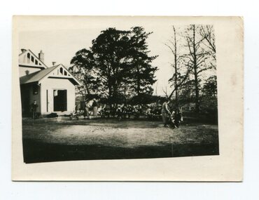
... Orbost, East Gippsland, Victoria, Australia...Orbost & District Historical Society Ruskin Street Orbost gippsland "The 19th of March 1886 proved an important day in the lives of many early settlers in the Orbost area, because on this day the Orbost State School opened. ..."The 19th of March 1886 proved an important day in the lives of many early settlers in the Orbost area, because on this day the Orbost State School opened. The fact that the school had first operated temporarily in a leased building, and on a half-time basis with SS2745 Jarrahmond, did not dampen the enthusiasm of the local inhabitants as they saw their offspring commence their education under the guidance of HT Campbell Mackay. However he remained in charge only until 12th of May 1886. The second HT, John Rowe, served until 1908. On 30th of June 1887, a portable room was provided; it being brought to the area by schooner. The school now had accommodation for 30 pupils; the teacher's welfare was considered because quarters of two rooms were attached. As the population increased so did the needs of the school. This was reflected in the provision of a larger classroom in 1898. During 1910-11 the first approaches were made to the Department for the establishment of a HES in Orbost and this became a reality in 1912. Orbost HES supplied post-primary education in the district until a high school was built in 1948. When fire destroyed the school in 1941 local halls were used as classrooms until a new school was built. Work was quite rapid and a new brick structure was opened by the Hon. A. E. Lind, MLA, on 13th of February 1942. This new building was a fine type of school of which both the pupils and the HT Leslie Collins were indeed proud. But Orbost continued to develop and the new school was soon overtaxed. This resulted in the erection of two Bristol classrooms in 1947. By 1950, when the school population had reached 500 pupils the opening of the new school at Orbost North was welcomed by all concerned. In 1963 the Department purchased land diagonally opposite the school and developed it as a playing area. In 1965 two LTCs were opened in November, and in October 1968 the Brodribb School building was moved to SS2744 Orbost for use as a general purpose room." This item is associated with the history of education in Orbost.A black / white photograph of a group of students, some kneeling, some sitting, in a school yard. It is framed in grey buff cardboard with a photographer's stamp at the bottom.H. A. Dart Melbourne in gold print at the bottom.photograph-orbost-state-school -
 Orbost & District Historical Society
black and white photograph, C1898
... Jarrahmond, East Gippsland, Victoria, Australia...Orbost & District Historical Society Ruskin Street Orbost gippsland Jarrahmond School first opened on March 19th 1886. ...Jarrahmond School first opened on March 19th 1886. The head teacher, Campbell Mackay, worked on a part-time basis with Orbost State School. (info. John Phillips)This item is associated with the history of education in the Orbost district.A black / white photograph on thick card. It is of a teacher and students standing in the garden of Jarrahmond State School.on back - hand-written - J. Lynn - "Jarrahmond School, 85 years ago'orbost-education-jarrahmond-state-school -
 Orbost & District Historical Society
black and white photograph, 1962
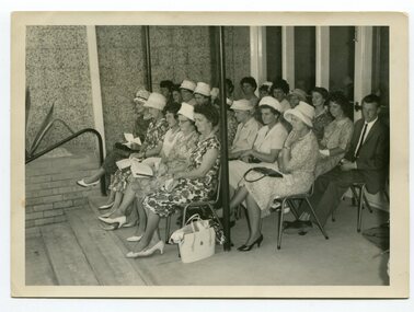
... Orbost, East Gippsland, Victoria, Australia...Orbost & District Historical Society Ruskin Street Orbost gippsland In 2012, Orbost Secondary College and the wider community celebrated 100 years of secondary education in Orbost. ...In 2012, Orbost Secondary College and the wider community celebrated 100 years of secondary education in Orbost. With earlier levels of schooling available at the Orbost State School or nearby schools of Newmerella and Jarrahmond School, it was not until April 1912, and after much campaigning from parents and other notable community members, that the Orbost Higher Elementary School was opened. Mr Richard Trembath was appointed the new Head teacher of Orbost Higher Elementary School and was assisted by Miss Olga Hirst. The senior class consisted of 26 pupils, and the junior class, 16 pupils. A limited curriculum was available which included lessons in Latin, Arithmetic, Algebra, Geometry, Geography, History, Drawing and advanced English. (info. O.S.C. website)Orbost High School / Orbost Secondary College has played a significant part in the education of senior students in the Orbost district . It is the sole senior educational institution. A black / white photograph of a group of ladies seated on chairs outside the Orbost High School.on back - hand-written - " Orbost H.s. Jubilee, 1962 - Welfare Ladies & Edna Towns, Joan Liddell" -
 Orbost & District Historical Society
black and white photograph, 1962
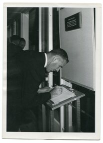
... Orbost, East Gippsland, Victoria, Australia...Orbost & District Historical Society Ruskin Street Orbost gippsland This is a photograph of Bruce Evans, Member of the Victorian Legislative Assembly, signing the visitors' book at the Orbost High School Golden Jubilee in 1962. ...This is a photograph of Bruce Evans, Member of the Victorian Legislative Assembly, signing the visitors' book at the Orbost High School Golden Jubilee in 1962. In 2012, Orbost Secondary College and the wider community celebrated 100 years of secondary education in Orbost. With earlier levels of schooling available at the Orbost State School or nearby schools of Newmerella and Jarrahmond School, it was not until April 1912, and after much campaigning from parents and other notable community members, that the Orbost Higher Elementary School was opened. Mr Richard Trembath was appointed the new Head teacher of Orbost Higher Elementary School and was assisted by Miss Olga Hirst. The senior class consisted of 26 pupils, and the junior class, 16 pupils. A limited curriculum was available which included lessons in Latin, Arithmetic, Algebra, Geometry, Geography, History, Drawing and advanced English. (inf0. from O.S.C. website)Orbost High School / Orbost Secondary College has played a significant part in the education of senior students in the Orbost district . It is the sole senior educational institution. A black / white photograph of a man in a suit signing a book.on back - hand-written -" Orbost H. S. Golden Jubilee 1962. Bruce Evans M.L.A. signing Visitors' Book>" -
 Orbost & District Historical Society
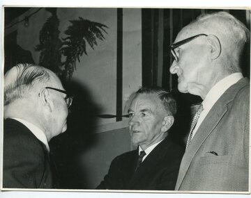
black and white photograph, 1962
... Orbost, East Gippsland, Victoria, Australia...Orbost & District Historical Society Ruskin Street Orbost gippsland This photograph was taken at the Orbost High School Golden Jubilee celebrations in 1962. ...This photograph was taken at the Orbost High School Golden Jubilee celebrations in 1962. It shows Crs Truscott, Mr R. Osborne (1960-1963 Orbost High School Headmaster, and Mr George Cameron.Orbost High School / Orbost Secondary College has played a significant part in the education of senior students in the Orbost district . It is the sole senior educational institution. A black / white photograph of three men in suits.on back - hand-written -" Orbost H.S. Jubilee, 1962, Crs. Truscott, Osbourne & Geo. Cameron"education-orbost orbost-high-school -
 Orbost & District Historical Society
black and white photograph, 1937
... Bete Bolong, East Gippsland, Victoria, Australia...Orbost & District Historical Society Ruskin Street Orbost gippsland In 1912 the school at Pumpkin Point opened to serve the children of farmers living in the Bete Bolong district. ...In 1912 the school at Pumpkin Point opened to serve the children of farmers living in the Bete Bolong district. This meant a big change in their way of life because in the past the children had been rowed across the Snowy River each day to attend school at Jarrahmond. Myrtle Bunting was the first HT of the school which had been erected on a block of land purchased from H. Richardson. The school functioned until 1952 when a shortage of pupils caused its closure. As a bus service to Orbost now operated, the school at Pumpkin Point faced permanent closure. J. McKeown bought the building.This item is associated with the history of education in the Orbost districtA small black / white photograph of students from the Bete Bolong State School at the District Sports.on back - S.S. Bete Bolongeducation-orbost bete-bolong-state-school -
 Orbost & District Historical Society
black and white photograph, C1900
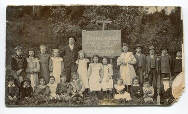
... Jarrahmond, East Gippsland, Victoria, Australia...Orbost & District Historical Society Ruskin Street Orbost gippsland This photograph was taken at an excursion for students of Jarrahmond State School and Bete Bolong State School to Fairleigh, the Jarrahmond home of the Lynn family. ...This photograph was taken at an excursion for students of Jarrahmond State School and Bete Bolong State School to Fairleigh, the Jarrahmond home of the Lynn family.This item is associated with the history of education in the Orbost district as well as with the Lynn family, a prominent family in early Orbost.Two black / white photographs - on original and one copy - showing a group of students sitting on a verandah.on back - handwritten -" Bete Bolong & Jarrahmond pupils at the home of Mr & Mrs Jim Lynne of Jarrahmond."education-orbost jarrahmond-state-school bete-bolong-state-school lynn-family-fairleigh -
 Orbost & District Historical Society
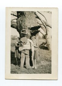
black and white photograph, 1936
... Bete Bolong, East Gippsland, v, Australia...Orbost & District Historical Society Ruskin Street Orbost gippsland In 1912 the school at Pumpkin Point opened to serve the children of farmers living in the Bete Bolong district. ...In 1912 the school at Pumpkin Point opened to serve the children of farmers living in the Bete Bolong district. This meant a big change in their way of life because in the past the children had been rowed across the Snowy River each day to attend school at Jarrahmond. Myrtle Bunting was the first HT of the school which had been erected on a block of land purchased from H. Richardson. The school functioned until 1952 when a shortage of pupils caused its closure. As a bus service to Orbost now operated, the school at Pumpkin Point faced permanent closure. J. McKeown bought the building. Students attending the school at this time included Russells, Johnstones, Reeves, Healeys, Kavanaghs, Phillips, Rodwells, Mills, Baileys, Gilberts and Masons.This item is associated with the history of education in the Orbost district.A black / white photograph of two Bete Bolong State School pupils - girls - standing against a large tree trunk with a scarecrow between them.on back - handwritten " Hilda Russell & Elsie Morrison on Guy Gawkes at Bete Bolong"education-orbost bete-bolong -
 Orbost & District Historical Society
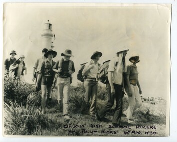
black and white photograph, 20th April 1970
... Point Hicks, East Gippsland, Victoria, Australia...Orbost & District Historical Society Ruskin Street Orbost gippsland The Captain Cook Bicentenary celebrations saw students from Orbost High School hiking around Cape Everard during the re-naming to Point Hicks. ...The Captain Cook Bicentenary celebrations saw students from Orbost High School hiking around Cape Everard during the re-naming to Point Hicks.This item is associated with Orbost High School and the historynof education in Orbost. It is also associated with the Captain Cook Bicentenary, a significant event in Australia's history. A large black / white photograph of a group of students from Orbost High School on a hike at Point Hicks.They are carrying backpacks along a trail and the Point Hicks lighthouse can be seen in the background.education-orbost point-hicks captain-cook-bicentenary -
 Orbost & District Historical Society
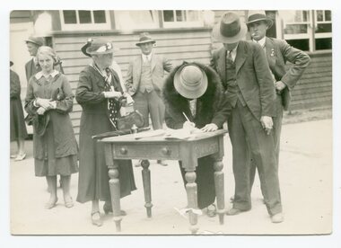
black and white photograph, 1st March 1937
... Orbost, East Gippsland, Victoria, Australia...Orbost & District Historical Society Ruskin Street Orbost gippsland This group is signing the visitors' book at the Orbost State School "Back To" on March 1 1937. ...This group is signing the visitors' book at the Orbost State School "Back To" on March 1 1937. The school burnt down three years later in 1940 under suspicious circumstances. In the photo are Mrs Ralston and Harold Rodwell.This item is associated with the history of education in Orbost.A black / white photograph showing a group of people standing waiting to sign a book which is on a small table. They appear to be outside the school building. A woman is bent signing the book. The men are wearing suits, one is smoking, the women well-dressed and most are wearing hats. on back - handwritten " Includes Mrs Ralston & Harold Rodwell. Signing Visitors' Book at 1937 Back to School"education-orbost orbost-state-school -
 Orbost & District Historical Society
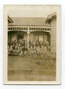
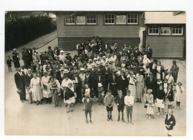
black and white photograph, 1st March 1937
... Orbost, East Gippsland, Victoria, Australia...Orbost & District Historical Society Ruskin Street Orbost gippsland This group of people are part of the 1937 "Back To' celebrations. ...This group of people are part of the 1937 "Back To' celebrations. The school building was burnt down in 1940 in suspicious circumstances.This item is associated with the history of education in Orbost.A black / white photograph of a large group of people standing outside the Orbost State School building.on back - handwritten" Back to School , 37"education-orbost orbost-state-school -
 Orbost & District Historical Society
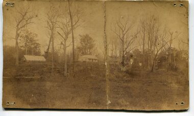
black and white photograph, 1850 - 1885
... Orbost, East Gippsland, Victoria, Australia...Orbost & District Historical Society Ruskin Street Orbost gippsland The Lochiel barn was used as the church for all denominations until 1885 when the parishioners were offered the use of a school room, then used the Mechanics' Hall after it was built in 1887. ...The Lochiel barn was used as the church for all denominations until 1885 when the parishioners were offered the use of a school room, then used the Mechanics' Hall after it was built in 1887. Mr James Cameron, fostered the developing Church, not only by allowing his barn at Lochiel Park to be used for Church services but also by making a home there for Mr Martin ,First Church of England clergyman stationed at Orbost - 1884-1891 over a period of years, until a small Vicarage was built on the spot where the present church stands. From Mr Cameron’s barn the church migrated to the school building erected in the main street and thence after a short time to the Mechanics Hall, built in 1887. This item is reminiscent of the late 19th - mid 20th centuries when church-going was more common.A very old black / white photograph of a house with a barn in the background. The house is on a bush block with many trees around it.on back - handwritten "From Mrs N Edgar, 4 "Heecer" Parade....... Lochiel + Barn M. Gilbert"church-orbost lochiel-barn -
 Orbost & District Historical Society
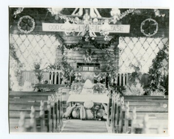
black and white photograph, C1900
... Orbost, East Gippsland, Victoria, Australia...Orbost & District Historical Society Ruskin Street Orbost gippsland The first Orbost Presbyterian Church was opened on January 9 1898. ...The first Orbost Presbyterian Church was opened on January 9 1898. It was built by Mr R. P. Cameron for three pounds. The Harvest Festival display was always put together by the church ladies. The Festival was a family friendly festival celebrating the end of summer.This item is reminiscent of the late 19th - mid 20th centuries when church-going was more common.A black / white photograph of inside the Orbost Presbyterian Church decorated with rural produce and flowers for the "Harvest Festival". It is on a white buff card with a blue photographer's stamp in the bottom left hand corner.on front - stamp -" Herbert Sherwood" on back - "M. Gilbert, Orbost" - "Mrs J. Sterling, 6 Marine Parade , Elwood"church-presbyterian-orbost harvest-festival -
 Orbost & District Historical Society
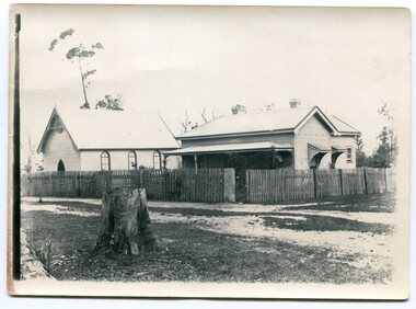
black and white photograph, C1900
... Orbost, East Gippsland, Victoria, Australia...Orbost & District Historical Society Ruskin Street Orbost gippsland This photograph is of the first Church of England in Orbost, dedicated on Sunday, 6th March, 1892 by the Rt. ...This photograph is of the first Church of England in Orbost, dedicated on Sunday, 6th March, 1892 by the Rt. Rev. T. Geo, Bishop of Melbourne, The church was later used in the `1970s by the Orbost State School as a music, physical education room until it was moved. The rectory was later moved so the new church could fit.This item is reminiscent of the late 19th - mid 20th centuries when church-going was more common.Three copies of the first Orbost Church of England with the small rectory adjacent.on back - "Mary Gilbert - Church of England"church-orbost church of england-orbost -
 Orbost & District Historical Society
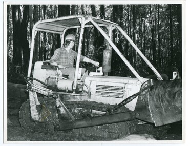
black and white photograph, VR Printing Works, 1975
... Orbost, East Gippsland, Victoria, Australia...Orbost & District Historical Society Ruskin Street Orbost gippsland This photograph, one of set of six, shows Ken Donchi, the youngest family member (at the time of photograph) at work as a sleeper cutter in the Orbost area since the 1890s. ...This photograph, one of set of six, shows Ken Donchi, the youngest family member (at the time of photograph) at work as a sleeper cutter in the Orbost area since the 1890s. The photograph was used in an article for the Victorian Railways Magazine 1975. . It contains photographs and an article about Orbost as "Timber Country" and a detailed article titled, " Cutting Sleepers is a Family Business" which tells about the Donchi family.This item is associated with the timber and sleeper-cutting industry in the Orbost Region. Timber sleepers were superceded by concrete sleepers in c. 1970s. Orbost has historically been based on the timber industry, but that industry has declined considerably over the last 20 years. .The number of locals involved in the timber industry has declined and many of the mills have closed. This item reflects a time when that industry was a significant contributor to the economy of the district.A black / white photograph of Ken Donchi driving a bulldozer in bushland outside of Orbost.on back - Pr 8769donchi-pat sleeper-cutting timber-industry-orbost-railway -
 Orbost & District Historical Society
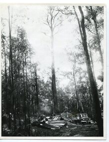
black and white photograph, 1975
... Orbost, East Gippsland, Victoria, Australia...Orbost & District Historical Society Ruskin Street Orbost gippsland The Donchi family has been cutting sleepers since the 1890s in the Orbost area. ...The Donchi family has been cutting sleepers since the 1890s in the Orbost area. This photograph , one of a set of six, was taken for an article in the Victorian railways Magazine in 1975. This was a pamphlet produced for Victorian Railways. . It contains photographs and an article about Orbost as "Timber Country" and a detailed article titled, " Cutting Sleepers is a Family Business" which tells about the Donchi family.This item is associated with the timber and sleeper-cutting industry in the Orbost Region. Timber sleepers were superceded by concrete sleepers in c. 1970s. Orbost has historically been based on the timber industry, but that industry has declined considerably over the last 20 years..The number of locals involved in the timber industry has declined and many of the mills have closed. This item reflects a time when that industry was a significant contributor to the economy of the district.A black / white photograph of a bush scene of a timber harvesting coupe used by the Donchi family.on back - Pr 8766sleeper-cutting-orbost donchi-orbost timber-industry-orbost -
 Orbost & District Historical Society
black and white photograph, VR Printing Works, 1975
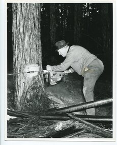
... Orbost, East Gippsland, Victoria, Australia...Orbost & District Historical Society Ruskin Street Orbost gippsland Pat Donchi's grandfather came to Orbost to cut sleepers in the 1890s. ...Pat Donchi's grandfather came to Orbost to cut sleepers in the 1890s. Pat and his sons have carried on since then. This photograph, one of six, was taken for the Victorian railways Magazine in 1975, a pamphlet produced for Victorian Railways. It contains photographs and an article about Orbost as "Timber Country" and a detailed article titled, " Cutting Sleepers is a Family Business" which tells about the Donchi familyThis item is associated with the timber and sleeper-cutting industry in the Orbost Region. Timber sleepers were superceded by concrete sleepers in c. 1970s. Orbost has historically been based on the timber industry, but that industry has declined considerably over the last 20 years. The number of locals involved in the timber industry has declined and many of the mills have closed. This item reflects a time when that industry was a significant contributor to the economy of the district.A black / white photograph of Pat Donchi, a local sleeper cutter, falling a tree with a chainsaw.on back - Pr 8708timber-industry-orbost donchi-orbost sleeper-cutting-orbost -
 Orbost & District Historical Society
black and white photograph, VR Printing Works, 1975
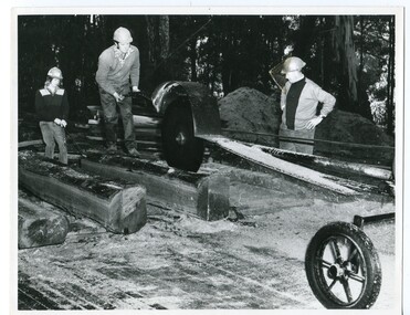
... Orbost, East Gippsland, Victoria, Australia...Orbost & District Historical Society Ruskin Street Orbost gippsland The Donchi family has ben involved in sleeper cutting in the Orbost district since the 1890s. ...The Donchi family has ben involved in sleeper cutting in the Orbost district since the 1890s. This phootograph , one of a set of six, was taken for the Victorian Railways Magazine, August,1975, a pamphlet produced for Victorian Railways. It contains photographs and an article about Orbost as "Timber Country" and a detailed article titled, " Cutting Sleepers is a Family Business" which tells about the Donchi family.Name Associated with the timber and sleeper-cutting industry in the Orbost Region. Timber sleepers were superceded by concrete sleepers in c. 1970s. Orbost has historically been based on the timber industry, but that industry has declined considerably over the last 20 years. The number of locals involved in the timber industry has declined and many of the mills have closed. This item reflects a time when that industry was a significant contributor to the economy of the district.A black / white photograph of Pat, Ken and Alan Donchi working a large saw at a timber coupe in Orbost.on back - Pr 8767timber-industry-orbost sleeper-cutting-orbost donchi-family -
 Orbost & District Historical Society
VR Printing Works, 1975
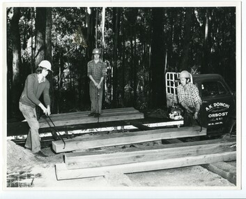
... Orbost, East Gippsland, Victoria, Australia...Orbost & District Historical Society Ruskin Street Orbost gippsland The three men in this photograph, one of a set of six), are all from the Donchi family who have been involved in sleeper - cutting since the 1890s. ...The three men in this photograph, one of a set of six), are all from the Donchi family who have been involved in sleeper - cutting since the 1890s. From left to right they are Brian, Ken and Alan Donchi. The photograph was taken for an article in the Victorian Railways Magazine in 1975, a pamphlet produced for Victorian Railways. It contains photographs and an article about Orbost as "Timber Country" and a detailed article titled, " Cutting Sleepers is a Family Business" which tells about the Donchi family.This photograph is associated with the timber and sleeper-cutting industry in the Orbost Region. Timber sleepers were superceded by concrete sleepers in c. 1970s. Orbost has historically been based on the timber industry, but that industry has declined considerably over the last 20 years..The number of locals involved in the timber industry has declined and many of the mills have closed. This item reflects a time when that industry was a significant contributor to the economy of the district.A black / white photograph of three members of the Donchi family working at sleeper - cuttingin a timber coupe in Orbost.on back - Pr 8764timber-industry-orbost sleeper - cutting donchi-family-orbost -
 Orbost & District Historical Society
black and white photograph, VR Printing Works, 1975
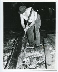
... Orbost, East Gippsland, Victoria, Australia...Orbost & District Historical Society Ruskin Street Orbost gippsland This is one of a set of six photographs taken for the Victorian Railways Magazine, a pamphlet produced for Victorian Railways. t contains photographs and an article about Orbost as "Timber Country" and a detailed article titled, " Cutting Sleepers is a Family Business" which tells about the Donchi family The man in the photograph is Pat Donchi, a member of the Donchi family, who have been involved in the sleeper - cutting industry since the 1890s. ...This is one of a set of six photographs taken for the Victorian Railways Magazine, a pamphlet produced for Victorian Railways. t contains photographs and an article about Orbost as "Timber Country" and a detailed article titled, " Cutting Sleepers is a Family Business" which tells about the Donchi family The man in the photograph is Pat Donchi, a member of the Donchi family, who have been involved in the sleeper - cutting industry since the 1890s. This item is associated with the timber and sleeper-cutting industry in the Orbost Region. Timber sleepers were superceded by concrete sleepers in c. 1970s. Orbost has historically been based on the timber industry, but that industry has declined considerably over the last 20 years.The number of locals involved in the timber industry has declined and many of the mills have closed. This item reflects a time when that industry was a significant contributor to the economy of the district.A black / white photograph of a sleeper cutter at work swinging a broad axe.on back - Pr 8765timber-industry-orbost sleeper-cutting-orbost donchi-family