Showing 10079 items
matching 2 photos
-
 Kiewa Valley Historical Society
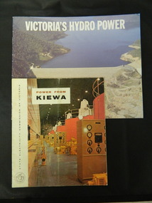
Booklets - Kiewa Hydro Electric Scheme, 1. "Power From Kiewa" and 2. "Victoria's Hydro Power", 1. Made in July 1968 and 2. Made in Aug. 1985
1. The State Electricity Commission of Victoria built the Kiewa Hydro Electric Scheme from the 1930's to the 1960's. This booklet was to inform visitors and to promote tourism. 2. The State Electricity Commission built several hydro power stations from 1928 - 1981. This booklet names each with a summary and explanation.The State Electricity Commission of Victoria built the Kiewa Hydro Electric Scheme establishing infrastructure such as the Bogong and Mt Beauty townships and the opportunity for tourism in the area.1. Colored soft cover with photo of McKay Creek Power Station on the front and Mt Beauty township on the back. Published by the SECV 2. Colored soft cover with Rocky Valley Dam on the front and inserted photo of a stream and snow on the back. Published by the SEC.state electricity commission of victoria; kiewa hydro electric scheme; victoria's hydro electric power; kiewa; mckay creek power station; clover power station; west kiewa power station -
 Kiewa Valley Historical Society
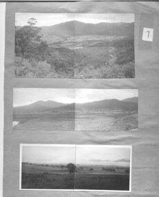
Photos - Mt Beauty Buildings in 1973. Set of 8, 1973
The shopping centre in Mt Beauty, both buildings and streetscape, have undergone significant changes since 1973. The kindergarten has undergone extensive remodelling, The Chalet has been replaced by Svarmisk Resort and Accommodation Spa. Tawonga hospital has undergone extensive renovation and is now Mt Beauty Hospital AND Kiewa Valley House. The Workman’s Club changed name to the Country Club and has since closed down. Hospital and Kiewa Valley House now occupy what is shown as a vacant lot opposite the motel which is now called Mt Beauty Motor Inn.The houses in Mt Beauty were brought in by the State Electricity Commission of Victoria when they constructed Mt Beauty Town for their workers building the Kiewa Hydro Electric Scheme. Mt Beauty is unique began as a construction town in the late 1940's.Colour photographs of various buildings in Mt Beauty taken in 1973 1. Workman’s Club 2. View over the pondage 3. Tawonga Hospital (Mt Beauty) 4. Mt Beauty Chalet 5. Mt Beauty Kindergarten 6. The Merjei Motel 7. 8 Valley Avenue 8. Shopping Centre Handwritten in ink on the back of photos 1. Workman’s Club 1973 (after the brick makeover) From the sports oval – the high school is to the right 2. A view over the pond 1973 3. Tawonga Hospital 1973 (Mt Beauty) 4. Mount Beauty Chalet 1973 5. Kindergarten 1973 6. The Merjei Motel 1973 7. Our house at 8 Valley Ave 1973, Owner after us erected the car port, let the front hedge run amok and vanquished the vegetable garden and citrus trees Dad created. 8. Shopping Centre 1973. At the end of the street is the hospital (believe it is now Mt Beauty Bush Nursing Hotel) mt beauty, workman's club, chalet, tawonga hospital -
 Kiewa Valley Historical Society
Photos - Mt Beauty and Surrounds, March 1960
Photos of the Kiewa Hydro Scheme and townships as they were in March 1960Pictorial record of the Hydro Electric Scheme in the 1960's when it was operated by the State Electricity Commission of Victoria (SECV). With the privatisation of the SECV in the 1990's the scheme passed to Southern Hydro and was then acquired by ALG Energy in 2005.4 black and white photographs of the Kiewa Valley area taken on a tour of the Kiewa Hydro Electric Scheme in March 1960 1. Mt Beauty township taken from the Mt Beauty Chalet 2. Mt Bogong, taken from Tawonga Gap 3. McKay portal pipeline 4. Bogong townshipmt beauty, kiewa hydro electric scheme, bogong, secv -
 Kiewa Valley Historical Society
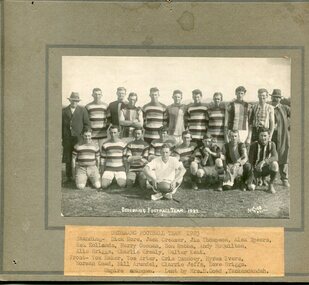
Photos - Dederang Football Club Team Photos - Set of 2 - 1919 and 1923, 1. 1923 2. 1919
... Photos - Dederang Football Club Team Photos - Set of 2... underneath photo, Typed names of team players 1. Dederang Football ...The Dederang-Mt. Beauty Football Club, nicknamed the Bombers, is an Australian rules football club playing in the Tallangatta & District Football League. The club is based in Dederang, Victoria and Mount Beauty, Victoria. It was formed in the early1900s and disbanded in 1976 when it merged with Mount Beauty to form Dederang-Mount Beauty football club. In 1948 the competition received a boost with an influx of new players who came to work on the Kiewa Hydro Scheme. George and Gordon Hobbs were the famous Hobbs brothers of Dederang which two Premierships were built around. Four brothers starred in Dederang’s First Flag in the Tallangatta League in 1958. Dederang Football Club was one of the earliest recorded football clubs in the Kiewa Valley area. Many players came from pioneering farming families in the area and there were often several boys from the same family playing in the team. Dederang won its first flag in the Tallangata League in1958 led by the Hobbs brothers Rex, Colin, Ken and Jack2 original black and white photographs of Dederang football club teams. Mounted on heavy card 1. Dederang Football Team – 1923 2. Dederang Football Team – 1919 Glued underneath photo, Typed names of team players 1. Dederang Football Team – 1923 Standing- Dick Hore, Jack Creamer, Jim Thompson, Alex Speers, Rex Hollands, Harry Goonan, Son Hobbs, Andy McQuilton, Alie Briggs, Charlie Grealy, Walter Keat. Front- Tom Baker, Tom Arter, Chris Quonoey, Hyram Ivers,Norman Coad, Bill Arundel, Clarrie Jeffs, David Briggs. Umpire unknown. Lent by Mrs D Coad Yackandandah 2. Dederang Football Team – 1919 Standing- Tom Hollands, Mick Tooey, Rex Hollands, Charlie Grealey,Jack Charles, HyramIvers, Mr Hewitt, Andy McQuilton, Alex Speers, Jack Creamer, Andrew Nettie. Front- Norman Coad, Bill Goonan, Rex Ellis, Davis, Umpire, V Donaghu, Bev Day, Barny Keegan, Mick Hynes. Lent by Mrs D Coad, Yackandandah dederang, football -
 Kiewa Valley Historical Society
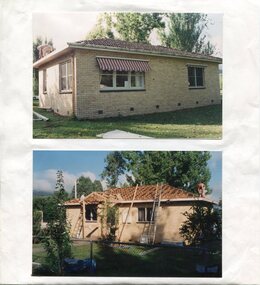
Photographs x 2 - Mount Beauty Infant Welfare Centre, February 1994
During the 1950's, Mt Beauty's population was rapidly increasing due to the post war baby boom and because there was a young workforce moving into the area due to the opportunity available for work on the construction of the Kiewa Hydro Electric Scheme. Maternal Infant Welfare Centre Sisters conducted regular check-ups on babies to ensure they were feeding well, gaining weight and reaching appropriate milestones for their age.Infants and young children in the Kiewa Valley area continue to be monitored by the Maternal Health Nurses to ensure their healthy development. The photographs are an historical record of early buildings in the Mt Beauty area, their uses and how they have changed to meet the changing needs of the community.2 x colour photographs of renovations to Mt Beauty Infant Welfare Centre. Mounted on white A4 copy paperPrinted at bottom of page underneath photos - Mt Beauty Infant Welfare Centre February 1994. Replacement of tile roof with Colourbond corrugated iron and construction of covered entry porch.mt beauty, infant welfare centre -
 Kiewa Valley Historical Society
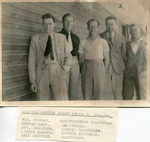
Set of 4 photographs of SECV Clerical staff, 1940 - 1941
The Kiewa Hydroelectric Scheme is the largest hydro-electric scheme in Victoria and the second largest in mainland Australia after the Snowy Mountains Scheme. The scheme is situated in the Australian Alps in north-eastern Victoria about 350 km from Melbourne and is wholly owned by AGL Energy. The scheme was originally constructed between 1938 and 1961 by the State Electricity Commission of Victoria although it was privatised in the 1990s. The scheme was originally developed solely for electricity generation, unlike the Snowy Mountains Scheme, which was also intended to direct water west of the Snowy Mountains for purposes of irrigation. From 1937 to 1944 the construction of dams at Pretty Valley, Rocky Valley and the Junction Dam were undertaken requiring large numbers of planning and support staff to see the projects successfully completed. Planning and support staff were the backbone of the successful completion of the Kiewa Valley Hydro Electric Scheme and contributed significantly to the development of the Kiewa Valley area. Many descendants of the men in the photographs still living and working in the local areaSet of 4 black and white photographs of SECV clerical staff – Circa 1940/1941Typed on note glued to back of each photo, Numbers handwritten in blue ink in top left hand corner 1. DRAWING OFFICE STAFF KIEWA C. 1940-41 Bob Morgan – Construction Draftsman; Duncan Kerr – Draftsman; Rob Hollands – Survey Draftsman; Arthur Keeble – Office Engineer; Bill Godfrey – Draftsman 2. CLERICAL OFFICE STAFF KIEWA Peter Harnetty – Clerical; Bert Connors – Clerical; John Martin – Stores Clerical; Ken Calder – Head Storekeeper; Bill black – Construction Records 3. CLERICAL OFFICE STAFF KIEWA Jack Norman, Herb Kendall, Jack Bray – Stores Clerical; Ken Calder – Head Storekeeper; Jim Swain, George Milner – Stores Clerical; Jim Gleeson – Storekeeper; John Martin – Stores Clerical 4. OFFICE STAFF KIEWA C. 1940 Don Faulkner – Cadet Engineer; Tas Davies – Survey Draftsman; Bob Morgan – Construction Darftsman; R.J. Martin, Arthur Keeble – Office Engineers; Rob Hollands – Survey Draftsman; Jack Wollard – Head Surveyor; Harry Wilson – Plan Officer. Printing Plans Handwritten in red ink on back of photo 4 – Refer Rob Hollands secv clerical staff -
 Kiewa Valley Historical Society
3 X photographs of early residents of the Kiewa Valley, 1. 1949-1950
The 3 photographs are of early residents of the Kiewa Valley who have pursued varying careers. Pictorial history of early residents of the Kiewa Valley giving an insight into the accomplishments of some local residents ie: R Nicholls and T Hotter travelled from New Zealand to work in the Kiewa Valley. J.H. Thompson pursued a career as a police officer. W.M. Sloan and his father built the water wheel at Junction Creek.1. Black and white photograph of Rod Nicholls and Tom Hotter, both of Mt Egmont New Zealand 2. Black and white photograph of J.H Thompson Former pupil of Mongan’s Bridge School 3. Black and white photograph of W M Sloan taken in 1880’s. Photograph is an oval within a larger rectangle 1. Handwritten in black pen on back of photo – Rod Nicholls (wearing hat) & Tom Hotter Both of Hawera (Mt Egmont) New Zealand 1949 – 1950 2. Handwritten on the back of photograph in ink J H Thompson, A fond memory for Mrs. Fisher, Everil & Paddy. Former pupil of Mongan’s Bridge school 3. Handwritten on back of photograph in blue ink – W M Sloan. He and his father built the water wheel 1880’s on Junction Creek (Bakers) j h thompson, fisher family, mongan's bridge, w m sloan, kiewa valley -
 Kiewa Valley Historical Society
Photographs x 2 - Afternoon tea visit to Towong Hill
Towong Hill Homestead is a 110-year-old Federation style mansion situated on a rock outcrop, with views of about 260 degrees. It was built over 2 years by grazier Walter Mitchell from bricks made from local clay dug from the river bank, to be the family home for his new bride Winifred. They established their home in 1904. After the death of Walter in 1917, Winifred relocated her family, but the homestead remained in the families hands. In 1935, Thomas Mitchell (1906-1984) returned home to Australia, a successful Lawyer, and married city girl, Elyne Chauvel, and settled himself back at his childhood home, Towong Hill. Thomas was a world champion slalom skier, had been a prisoner of the Japanese at Changi, and was elected for the Country Party in 1946 and served as attorney-general in the McDonald government. His wife Elayne (1913-2002) is best remembered for her Silver Brumby series of novels for children. But Elyne also wrote a substantial number of non-fiction works about the Snowy Mountains. Photographs demonstrate local Kiewa Valley residents enjoying a community visit to the historic homestead at Towong Hill which holds significance to the early history of the area. Also demonstrates a pictorial history of social activities undertaken during this period2 black and white photographs mounted on buff card. Kiewa Valley residents attending afternoon tea at Towong HillHandwritten in black pen underneath photo - T.W.Mitchell Towong Hill. Afternoon Teat w mitchell, towong hill, kiewa valley -
 Kiewa Valley Historical Society
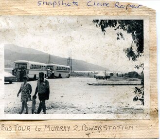
Photograph- Bus tour to Murray 2 Power Station
The Murray Region Hydroelectric Power Stations are two of seven hydro power stations, located near Khancoban in NSW. The two power stations are part of the Snowy Mountains Hydro-electricity Scheme, which is an extensive hydroelectricity and irrigation complex constructed in south-east Australia between 1949 and 1974 and now run by Snowy Hydro. Although both power stations are located in NSW, since 1 July 2008 all power generated has been allocated to the Victorian region of the National Electricity Market. Murray 2 Power Station was the first in the Snowy Scheme to use Japanese supplied large electrical and mechanical components Photographs demonstrate local Kiewa Valley residents enjoying an educational visit to Murray 2 Power Station which holds significance to the early history of the Hydro-electric Scheme in the area. Also demonstrates a pictorial history of social activities undertaken during this periodBlack and white photograph mounted on buff card Bus tour to Murray 2 Power Station showing 2 buses and group of Kiewa Valley residentsHandwritten in blue ink above photo "Snapshots Clare Roper' Handwritten in black ink below photo "Bus tour to Murray 2 Power Station'kiewa valley residents, clare roper -
 Kiewa Valley Historical Society
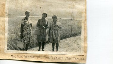
Photographs x 2- Groups of Kiewa Valley residents on tour of Khancoban area
Demonstrates a pictorial history of social activities undertaken by Kiewa Valley residents during this period possibly 1970’s to 1980’s. Also a pictorial record of residents of the Kiewa Valley during this period. Photographs demonstrate local Kiewa Valley residents enjoying a community visit to the Khancoban area, which holds significance to the early history of the district. Its heritage is celebrated in Banjo Paterson’s epic poem, “The Man from Snowy River”. 2 black and white photographs mounted on buff card. 1. Group of ladies on a tour of the Khancoban area 2. Mixed group of ladies and men on a tour of the Khancoban area 1. Handwritten in black ink below photo 'Mrs Van Der Weyde, Mrs Storey, Mrs Temple 2. Handwritten in black pen below photo 'A.O. Smith, A. Angus, Mrs. Pullin, S. Ross, C. Roper, Mrs Temple, A. E. Campbell (name of last person obscured)kiewa valley residents, clare roper -
 Kiewa Valley Historical Society
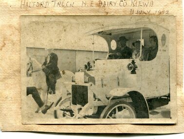
Photographs x 2- Halford truck, 1. 11/7/1972 2. Unknown
The Hallford truck was made by J & E Hall, of Dartford, England, whose business commenced in 1785. In 1926 the Fisher family of Mongan's Bridge took delivery of the 1923 Hallford truck which was used on the farm to transport cream to the Kiewa Butter Factory in Tangambalanga. In 1967, the truck was sold to Mr Greg Bedstead and other members of the Kiewa Valley Historical Society for the KVHS who reimbursed them at a later date. The truck was housed at the Butter Factory for many years and was paraded on special occasions.This truck was used to transport cream to the Kiewa Butter Factory from the Fisher family's dairy farm at Mongan's Bridge. At other times a tyre was removed and a belt attached to run a chaff cutter. This truck has historical significance as it is presentative of vehicles which were used by farmers to transport cream to the butter factories by a local family. Furthermore, it has social significance as KVHS members combined their finances to purchase this truck so it would be part of our collection. It is well provenanced and has an excellent interpretive capacity.2 black and white photographs mounted on buff card 1. Photograph of Halford truck with man on white horse riding alongside. Presumably in a parade. Dated 11th July, 1972 when truck was no longer in service. 2. Photograph of Halford truck followed by a horse and buggy. Date unknown1. Handwritten in black ink above photo 'Halford truck N.E. Dairy Co. Kiewa. 11 July, 1972' 2. No markingshallford truck, fisher family, kiewa valley farmers, dairy truck -
 Kiewa Valley Historical Society
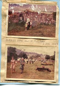
Photographs x 2- D Reids home at Mill Park 1973, 2/12/1973
... Park. 2 Dec 1973 2. Handwritten in blue ink under photo ...David Reid (1820-1906) was a pastoralists and politician. He left school at 16 and after meeting the overlander John Gardiner he decided to look for land south of the Murray River. Equipped by his father with some 500 head of cattle, 2 bullock wagons and teams and 6 assigned servants, he reached the Ovens River on 8 September 1838. David settled at Currargarmonge, near Wangaratta. At the end of 1843 he took up land near Yackandandah. In 1847 he took up a section of the family run of which Woorajay (Wooragee) formed a part. He built the first water driven flour-mill in the district on his Yackandandah run in 1845; his woolclip of 1848 was one of the first to be handled by R. Goldsbrough and was claimed to come from sheep descended from stock imported in the 1820s from George III's flock. Going into politics, he held the Legislative Assembly seat of Murray from October 1859 to May 1862. David Reid was a highly regarded grazier and local politician who was significantly involved in settlement around the Yackandandah area. Photo demonstrates ongoing interest in the local history of the area and its early residents2 colour photographs mounted together on buff card 1. Man and 2 children (unidentified) standing outside the remains of the Reid home. 2 Dec, 1973 2. Group of unidentified people on a tour of the old homestead of D. Reid. 2 Dec, 19731. Handwritten in black ink under photo 'D. Reid's home 1845. At Mill Park. 2 Dec 1973 2. Handwritten in blue ink under photo 'Snapshots Clare Roper"clare roper -
 Kiewa Valley Historical Society
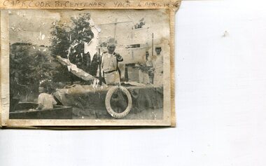
Set of 3 photographs= Captain Cook Bi-Centenery parade, 04/04/1970
The Captain Cook bicentenary was commemorated in Australia in 1970. The British explorer Lieutenant (later Captain) James Cook sailed and charted the East Coast of Australia in 1770, and claimed the Eastern Seabord of the Continent for the British Crown. This is not considered the official bicentenary of Australia, but rather the mapping of the Eastern coastlineLike many other towns around Eastern Australia, Yackandandah celebrated the bi centenary with a street parade, enjoyed by residents of surrounding areas including the Kiewa Valley3 black and white photographs mounted on buff card. Photographs taken at Captain Cook bi-centenary parade and celebrations in Yackandandah on April 4th 1970 1. Float depicting Captain Cook and sailors aboard the H. M. Endeavour 2. Local children on horseback possible representing the pony club. 3. Group of spectators standing outside the post office. One unidentified person dressed as a golliwogHandwritten in black ink above photo 1 "Capt. Cook Bi Centenary. Yack. 4 April 1970 (last number of date unclear) No marking on other photosyackandandah, parade, clare roper -
 Kiewa Valley Historical Society
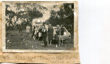
Photographs x 2- Bus tour of Wallaces Hut, 20/02/1970
Wallace's hut was built in 1889 and is probably the oldest surviving hut on the high plains of north-east Victoria. It was built in six weeks by Irish immigrant brothers Arthur, William and Stewart Wallace among old snow gums on a grassy plain above the snowline. The brothers held grazing leases on the High Plains and the hut was built to provide shelter for the cattlemen working there. It is probably the oldest hut on the Victorian high plains. It is part of the early history of hydroelectricity in the state and has links with early SEC meteorological data recording in the area Apart from its historical significance, Wallace’s Hut is a popular stop for tourists and photographers and is the starting point for the Wallace’s Heritage trail, which is a popular and well used hiking track, by locals and visitors alike.2 black and white photographs mounted on buff card. Photos taken during a bus trip to Wallace's Hut on Feb. 20, 1970 1. Group of local Kiewa Valley residents on a bus tour to Wallace's hut 2. Group of adults and children pictured outside Wallace's hut1. Handwritten in black ink on bottom of photo 'Wallace's Hut, Bogong High Plains, 20 Feb, 1970 2. No markingswallace's hut, bogong high plains, bush walking, cattlemen -
 Kiewa Valley Historical Society
Photographs x 2 1. Lake Guy & Bogong Village 2. Bulldozer moving rocks
1. In 1940 Field Headquarters for the Kiewa Scheme were established at Bogong with office, workshop facilities and accommodation for workmen, staff and some families constructed. (There had been a 'tent camp' on this site in 1939 but was destroyed by bushfires) Construction of accommodation continued until 1947. A total of 40 houses plus a hostel for single staff, post office, police station, medical centre and primary school all with water and sewerage and electricity supply. The staff hostel was known as Kiewa House and is now occupied by the Education Department. Lake Guy was named after Mr. L.T. Guy who was the Resident Engineer in charge of construction work and associated activities on the Kiewa area. He held this position from 1939 to November 1946 when he was transferred to Head Office. 2. Example of the type of heavy machinery used in clearing and building of Lake Guy, Bogong Village and Clover Dam 1. The Bogong Township was developed firstly as an accommodation centre (base camp) for construction workers employed under the Kiewa Hydroelectric Scheme. At the completion of the scheme, in the 1960's, the village was opened to public/tourism use. Strict environmental control has not allowed for any extensive redevelopment in tourist accommodation and basically restricted it to the accommodation initially built for the construction workers. Lake Guy is one of the many water storage reservoirs used to supply the power stations their main power to run the huge turbines generating the final product, electricity 2. Pictorial record of the types of machinery used in the development of Bogong Village and the Hydro-electricity scheme including the Clover Dam. Note the lack of safety equipment worn by construction workers of the period. 2 black and white photographs taken at Bogong 1. Lake Guy with Bogong Village in the background 2. Workman in bulldozer clearing rocks, possibly for construction at Bogong1. Handwritten in blue ink on back of photo 'Lake Guy showing Bogong Village' 2. No markingslake guy, bogong village, secv -
 Kiewa Valley Historical Society
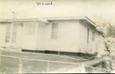
Photographs- Original S.E.C.V. home designs in Mt Beauty – Set of 6 black and white photographs
... Written in blue ink on front of photos 1. Winwood 2... Beauty houses SECV housing Written in blue ink on front of photos ...The townships of Mount Beauty and Bogong Village were constructed by the Victorian State Electricity Utility Commission (SEC) from the 1930’s to the 1950’s to house workers on the Kiewa Hydro Electric Scheme. At its peak the Kiewa Scheme employed around 4000 people. Although the towns were built as temporary accommodation for the workers and their families, many stayed and even retired there after the scheme had finished. The Bright Council, now the Alpine Shire took over the control of the township in 1960 and today Mount Beauty is one of the most complete company towns in Victoria.The SECV provided several standard designs for the housing of workers and management in Mt Beauty. At the completion of the scheme the housing was retained and Mount Beauty now exists as one of the best examples of a company town in Victoria.There are many examples of the original houses remaining around the town. This is significant as the houses were only built as temporary accommodation and still remain functional after over 60 or more years of use.Set of 6 black and white photographs of original SECV temporary house designs in Mt Beauty.Written in blue ink on front of photos 1. Winwood 2. Winwood 3. K Type 4. K Type 5. English Precut 6. Cube mt beauty houses, secv housing -
 Kiewa Valley Historical Society
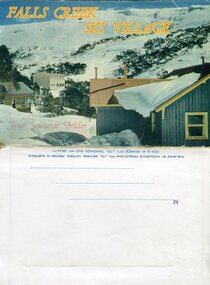
Souvenir Postcard Folder – Falls Creek Ski Village
After World War II, the Kiewa Hydroelectric Scheme was started in the Kiewa River valley by the State Electricity Commission of Victoria. On land previously used only for summer cattle grazing in the natural alpine grasslands, the first ski lodge was built in 1948 by workers from the scheme. The first lift, a rope tow, was built in 1951 and the first chairlift in Australia was constructed there in 1957. Falls Creek Post Office opened on 9 June 1958 (with telegraph and telephone facilities only until 1964) .Despite strong opposition from the head of the Kiewa scheme, who didn't want tourists clogging up his roads and destroying his "dry" construction camps by bringing in booze, Falls Creek boomed as much as Hotham, partly owing to its relatively good access road. Early lodges included Bogong (c.1946), Skyline (1947), Albury (1949), Myrtleford (1949) and Dawn (c.1950).The souvenir postcard photographed and produced by an enterprising local businessman Mr S K Pearce, was produced as a memento for skiers and other visitors to the Falls Creek and Mt Beauty area to send to family and friends as a reminder of their visit to the region, or to keep as a personal souvenir. It presented an excellent promotional opportunity for enterprising local businessmen to promote the area to skiers and tourists near and far. It also presents an excellent pictorial history of the falls creek area around the late 1950’s to early 1960’sColour postcard folder (unused) containing 13 photographs of the Falls Creek ski area and surrounds. Inside cover has a brief description of the area and the services available to visitors Printed on front cover- FALLS CREEK SKI VILLAGE. Your Souvenir Folder Photo of skiing slopes of the village Inside front flap - a brief description of the Falls Creek area and the services available to visitors 1. Diana Lodge parking area and Spion Kopje 2. Winterhaven Lodge 3. Ski Hirage Centre and skiing slopes 4. Ski Lodges from main road 5. Nelse and Arundel Lodges 6. Day visitors’ shelter and parking area 7. Summit T-Bar lift 8. Spur T-bar looking towards Village and Spion Kopje 9. T-bar lower station and Snow Crystal Inn 10. ‘Akja’ rescue sled in use 11. Falls Creek road and Grand Coeur Lodge annex 12. Rope tows and beginner slopes 13. Back cover- Published by Nucolorvue Pty Ltd Mentone Vic. Printed in Australia For S.K.Pearce Pty Ltd Tawonga and Mt Beauty falls creek, snow, bogong high plains, victorian alps -
 Kiewa Valley Historical Society
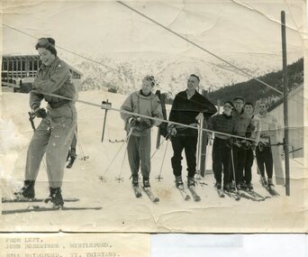
Photographs – Skiers at Falls Creek – Set of 10 black and white photographs
After World War II, the Kiewa Hydro-Electric Scheme was started in the Kiewa River valley by the State Electricity Commission of Victoria. On land previously used only for summer cattle grazing in the natural alpine grasslands, the first ski lodge was built in 1948 by workers from the hydro scheme as skiing was a popular recreation. Many of the hydro employees were of European background and had grown up enjoying skiing and snow sports in their homelands and were keen to continue to pursue their winter sports interests. The first lift, a rope tow, was built in 1951 and the first chairlift in Australia was constructed there in 1957. Two T-Bars were opened in 1961. In 1964, the Victorian Municipal Directory recorded that Falls Creek had 29 ski club lodges and 16 commercial lodges.Employees of the State Electricity Commission of Victoria in the Kiewa River Valley were the earliest skiers on the Bogong High Plains and built one of the first ski lodges at Falls Creek. They were amongst those pivotal in the development of the skiing and tourist industry at Falls Creek and on the Bogong High Plains. Set of 10 black and white photographs of various skiers at Falls Creek Victoria1. From Left-John Robertson Myrtleford; Bill Bridgford, St Trinians; Girl not known; Roy Wolpole, Myrtleford; Fin McAuliffe, Myrtleford; Looking on foreground, Toni St Elmo 2. Falls Creek. Property of State Electricity Commission of Victoria Publicity Photo Negative No PB4046. Publicity Branch, 15 William St Melbourne. 3. Avic Lajons 4. No markings 5. Bill Bridgeford (lower person on slope) 6. Max Lawrence? Facing skiers 7. 6575. Indistinguishable red stamp on back 8. 6875. Ces Dobson on tractor 9. From left on tow. John Robertson (Myrtleford); Bill Bridgeford (St Trinians); Girl unknown; Roy Walpole (Myrtleford); Vin McAuliffe (Myrtleford); Looking on foreground Toni Beveridge. 10. From Left 1; 2; 3. Bill Bridgeford; 4. George McPherson ? (Myrtleford); 5. John Robertson (Myrtleford); 6. Elsbeth Rollenson? (Myrtleford); 7; 8; 9. 11. Bogong. Looking N.E from Big River fire track. Skiers on way to Falls Creek. Spion Kop on left. Going around Ropers Cerner near the 18 mile post falls creek, skiing, bogong high plains -
 Kiewa Valley Historical Society
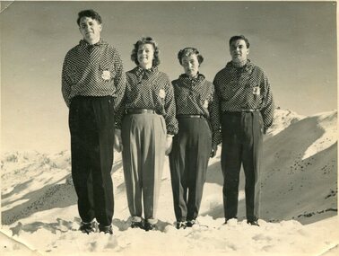
Photographs – Skippy St Elmo and other skiers – Set of 8 black and white photographs
Skippy and Toni St Elmo were responsible for early developments at the Falls Creek resort and for promoting a love of skiing. They left Melbourne in 1945 and settled at Falls Creek and moved into the first building constructed of corrugated iron and timber at Falls Creek in 1946. They were Falls Creek’s first workers with Toni employed by the State Electricity Commission to record weather-related data up to the construction of the Kiewa Hydro-Electric Scheme. In 1957, Toni was involved in building the first rope tow called Nissen on the same route as the Summit Quad. He also established the Nissen Ski School with ski instructor Milan Kovacic and was involved in the building of the resort’s first ski club Bogong in 1949. Toni taught Skippy to ski and she practised on the High Plains where she and her husband lived. Skippy St Elmo won many ski races during the 1950’s and represented Australia in New Zealand.Skippy and Toni St Elmo were pioneers of the Falls Creek area, promoting local ski sports and tourism. The played an important role in opening up the Falls Creek area and developing its sporting potential by establishing the first ski school, ski lifts and early lodge facilities. Skippy and Toni St Elmo were honoured at the Alpine Village at Falls Creek on November 17 2006, with the spreading of their ashes at the place which played such an important part in both their lives.Set of 8 black and white photographs of Skippy St Elmo and other skiers 1. Skippy and 3 others in New Zealand 1951 2. Skippy and 5 others Falls Creek 1955 3. Cake celebrating 20 years of sport at Nissen Lodge 4. Skippy and friend outside Nissen Lodge 5. Skippy on the ski slopes 6. Skippy on the ski slopes 7. Albury Ski Club team New Zwealand 1957 8. The Bogong Ski Club 1950 Written on back of photos 1. Bob Howe Albury, Skippy New Zealand 1951 – 942H 2. Falls Creek 1955. Skippy St Elmo: H Devonassore; Margaret ?; ?; Tony St Elmo; Olive? 3. Written on cake Nissen Alpine Club. 20 years of sport. FRED 4. Skippy St Elmo 5. Skippy 6. Skippy 7. Bob Howe (Albury) Skippy New Zealand 1957. Albury Ski Club Team raced in NZ 8. The Bogong Ski club, Coronet Park, 1950. M Denham (Capt); B Wiltshire; R Roberts; Skippy St Elmo; Gwen Morris; J Frazer; J Smith; L Piera; Manager & Coach Toni St Elmo. J D Knowles Photographer Box 188, Queenstown. 744B falls creek, skiing, bogong high plains -
 Kiewa Valley Historical Society
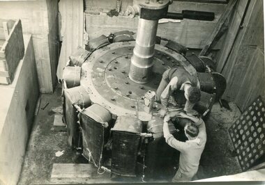
Photographs – SECV – Clover Power Station
The Junction Dam and Clover Dam Power Station, stages of the Kiewa Hydro-Electric Scheme, were needed to meet the increased power demands of the wartime industry in Victoria. Clover added 26 megawatts to the grid. Junction Dam was completed and ready to hold water by September 1943, but was emptied in December 1943 and not filled again until May 1944. Construction of Clover Power Station commenced in July 1941 and both turbines were in service by May 1945.Clover Power Station and Junction Dam were part of the Kiewa Hydro Electric Scheme constructed by the State Electricity Commission of Victoria.Set of 21 black and white photographs taken by the official SECV photographer who gave each photo a number prefixed by K (for Kiewa) K1367- 19 Nov 1943 The rotor for the generator K1368- 19 Nov 1943 Base of the generator K1377- 2 Dec 1943 Generator under construction K1380- 2 Dec 1943 Power Station under construction K1381- 2 Dec 1943 Generator being assembled K1386- 3 Dec 1943 Part of the generator K1389- 30 Dec 1943 Inlet pipe work K1391- 30 Dec 1943 Inside the power station K1392- 30 Dec 1943 Inlet pipe work K1396- 27 Jan 1944 Equipment in the power station K1410- 4 FGeb 1944 Unpacking equipment for the power station K1422- 16 Feb 1944 Generator being assembled K1425- 22 Feb 1944 Water way – power station K1433- no date Generator being assembled K1434- 3 Mar 1944 Constr5ucting the power station K1448- no date Generator inside the power station K1450- 17 Mar 1944 Clover Power station K1452- 17 Mar 1944 Looking down on the valve-water release from the power station K1456- 22 Mar 1944 ‘half Travel Opening- No 1 Relief Valve’ Overflow from the power station K1458- 22 Mar 1944 Outlet from the power station K1462- 22 Mar 1944 Inside the power station On the back- each photograph has a handwritten reference number starting with K and the date stamped or writtensecv; kiewa hydro electric scheme; clover power station; junction dam; bogong -
 Kiewa Valley Historical Society
Photographs –Collection of 10 copies and original black and white photographs and printed articles relating to skiing on the Bogong High Plains
After World War II, the Kiewa Hydro-Electric Scheme was started in the Kiewa River Valley by the State Electricity Commission of Victoria. On land previously used only for summer cattle grazing in the natural alpine grasslands, the first ski lodge was built in 1948 by workers from the hydro scheme as skiing was a popular recreation. Many of the hydro employees were of European background and had grown up enjoying skiing and snow sports in their homelands and were keen to continue to pursue their winter sports interests. The first lift, a rope tow, was built in 1951 at Falls Creek and the first chairlift in Australia was constructed there in 1957. Two T-Bars were opened in 1961. In 1964, the Victorian Municipal Directory recorded that Falls Creek had 29 ski club lodges and 16 commercial lodges. The area became a popular tourist destination for both winter and summer sports.: Employees of the State Electricity Commission of Victoria in the Kiewa River Valley were the earliest skiers on the Bogong High Plains and built one of the first ski lodges at Falls Creek. They were amongst those pivotal in the development of the skiing and tourist industry at Falls Creek and on the Bogong High Plains. Collection of 10 copies and original black and white photographs and printed articles relating to skiing on the Bogong High Plains. Some pieces have been enlarged to A3 poster size copies for display purposes 1. Copy of black and white photograph of group of skiers at Falls Creek 2. Copy of photograph of early skier on Bogong High Plains with temporary buildings and tents in the background 3. Copy of photograph of 3 skiers on Mt McKay 4. Copy of SECV photograph of Rocky Valley Camp under snow 5. Early sepia photograph of Falls Creek village with skiers in the foreground 6. Copy of a page from booklet (SECV?) promoting the benefits of owning a holiday home in the Bogong Village area 7. Copy of a page from booklet (SECV?) promoting the benefits of holidaying in and around Falls Creek/Mt Beauty 8. Panoramic view of ski fields with skis in the foreground 9. Photograph of young skier (identity unknown) 10. Photograph of 2 male skiers (identity unknown) performing a small jump 1. Bogong Ski Club Members & Friends 1944 2. Jack Neve – electrician. Rocky Valley 3. 17.5.55 Skiers ascending Mt McKay 4. State Electricity Commission of Victoria. Date:17.8.55 No:K8132 Kiewa Hydro Electric Works. Rocky Valley Camp – From Engineering Office 5 & 9 No markings 6 & 7 Short article relating to photos on each page 8. Handwritten signature on rear of photo (Sandra Conea) 10 Faded unreadable photographers stamp and handwritten numbers 6875 on rear secv; bogong high plains; skiers; falls creek; tourism -
 Kiewa Valley Historical Society
Photographs and copies of photographs of the pack horses and early horsemen who transported supplies to outposts in the Bogong High Plains, via cattle tracks before access roads were made
In the mid to late 1930’s survey outposts were established to plot the early stages of the Kiewa Hydro Electric System for the SECV in the Bogong High Plains. Before any roads were built, the old cattleman’s tracks were used with packhorses to deliver supplies, wages and mail and collect timesheets and correspondence from the workmen and dam builders living in canvas tents and at the outlying survey posts. The trip up the mountain was long and hard and dangerous for both horse and man Most of the men of the survey teams were not bush-men and were often ill equipped for the harsh weather and living conditions of bush camping, often arriving in their city clothes ready for work. The tent city at Bogong was destroyed by bush fires in 1939 after which an access road was built from Mt Beauty to transport building materials for more permanent dwellings for workmen. Pack horses continued to be used for transporting goods etc. to workers further up the mountain.Without the work of horsemen and their pack horses providing supplies and communications for outlying outposts, surveying and early planning for the Kiewa Valley Hydro Electric scheme could not have gone ahead and the dams and power stations which support the system could not have been constructed. The Hydro-electric scheme, and the workers who planned and built it play a major part in the early history of the Kiewa Valley and many original families still remain living, or have ties with the local area.: Set of 21 black and white photographs and copies of photographs depicting the pack horses and the men who handled them, transporting supplies and correspondence to the outlying camps and survey posts in the Bogong High Plains, via the rough cattlemen’s tracks. Photographs also show the early tent camps of the workers. Some photos mounted on A4 white paper. Some photos enlarged to A3 poster size for display1. Handwritten on back – Max Lawrence 2. -8 No inscriptions 9. Handwritten on back- Packing in supplies for early workers of the Kiewa Hydro scheme. There were no roads in the early days of the scheme 10. Printed on bottom of photo- Roper’s cattle on road below Howman’s Gap 11. Handwritten on back – Roper’s et al about to leave for the high plains 12. Printed under photo- Syd Ryder at the Pretty Valley Cut-Out (JBR) 13-16. No markings 17. Printed under photo- Gwen Talbot visits the Camp area. 1937 18. Handwritten on back- 14/1 Barbara Talbot 19. No markings 20-21. No markings 22. Printed under photo- STATE ELECTRICITY COMMISSION OF VICTORIA. Date: 15-3-45 Time: 8.0pm No: K 1838 Kiewa Hydro-Electric Works, Investigations 1944-1945 – Survey Camp at Young’s Hut pack horses; bogong high plains; survey posts; supplies delivery -
 Kiewa Valley Historical Society
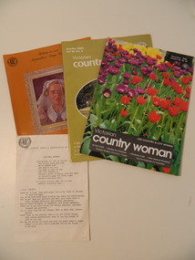
Journals - C.W.A, Victorian Country Woman for Country & City Women
Country Women's Association of Victoria was a popular widely known organisation throughout Australia. The CWA aimed to improve health, welfare and education for women and children in the country.Each town / area in the Kiewa Valley had an active CWA. The Tawonga branch commenced in Feb. 1946 and often combined activities with other branches in the Kiewa Valley.1. Nov. 2000, Vol. 46, No. 10. Cover: Purple & red tulips 2. October 2004 Vol. 50, No. 9 x2 Cover: Olive Green surrounding oval shaped photo 'The Log Cabin' 3. April 2001, Vol. 47, No. 3 Cover: Mustard surrounding square portrait of 'Nursing Sister Atherton, N. Qld.' 4. Agenda for the Annual Conference of the Kiewa Valley Group of the CWA of Vic.Also includes National Anthem, CWA Collect & Mottocountry women's association, journals, kiewa valley group of cwa -
 Kiewa Valley Historical Society
Roper's Hut Memorabilia
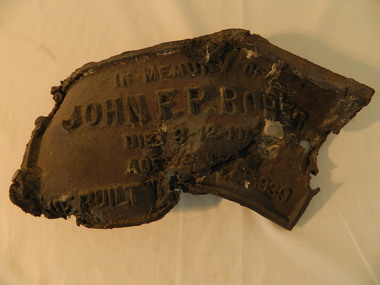
Roper's Hut was built in 1939 and was burnt down in 2003. It was rebuilt in 2008 and is situated on the Bogong High Plains on Duane Spur (where Duane's hut had been before it too was destroyed by (1939) bushfires, between Mt Nelse and Big River. The original hut was used as a shelter for cattlemen who grazed their cattle on the High Plains during summer. The Victorian High Country Huts Association Inc. members and friends helped rebuild the hut which is now used as an emergency shelter for visitors to the High Plains.The memorabilia is significant as the items belonged to the Roper family who were one of the original settlers of the Kiewa Valley and one of the original families who drove their cattle up to the Bogong High Plains. The burnt plaque and forks and the rebuilding of the huts (Duane's & Roper's) are significant as bush fires are a constant threat to the Bogong High Plains destroying large areas at a time.1. Bronze Plaque and 2 damaged forks from Roper's Hut which was destroyed by bush fires in 2003. 2. DVD & USB and hard copy photos of the rebuild of Roper's Hut in January 2008.The plaque had 'In Memory of / John F. P. Roper/ died 3-12-1977 / Aged 78 years / He built the original hut Feb. 1939'roper's hut, cattlemen, bogong high plains, bronze plaque, roper family, bush fires -
 Kiewa Valley Historical Society
Four photographs of the Blue Duck Hotel and two Photos of the Glen Wills area, c1920 Post cards, c1949/50 small photographs
The Blue Duck Hotel stands at the confluence of 3 trout rivers - Cobungra, Bundarra and Mitta Mitta, called Angler's Rest. The original 1900's building was of slab construction and operated as a butcher shop, servicing miners on the track from Omeo to Mt. Wills. In 1912 it was purchased by a miner, Billy O'Connell, and he obtained a hotel license. In the early 1920's he transported 2 houses from Omeo on Horse drays. One is the main building of the Blue Duck and the other was a residence where Billy and his wife raised their nine children. The small log structure behind the pub is State School No.4286 where the children attended school. A teacher was shared with Glen Wills. By the late 1920's the hotel was discovered and patronized by keen anglers. Sir Harold Clapp (head of the railways) was one and he had the bronze blue duck cast and presented to the owners in the 1930's. This stands at the entrance to the premises.These photographs are of a building, in a remote area, that has provided a service to miners, anglers and travellers for over 100 years and continues to do so today. It also played a vital role in the history of the Mt. Wills/Omeo gold mining days.3 Post cards, Black and White photographs. 3 small black and white photographsPost Card No. 1 - "Blue Duck Hotel- Omeo-Glen wills road Ray Love Series No.2"(written on lower front) Post Card No. 2- "Looking towards Bogong High Plains. Omeo-Glen Wills road"(front, bottom, L hand) Ray Love Series No. 18 (front, lower R hand corner) On both of above photos, centre back, is stamped POST CARD and underneath this is printed "A GENUINE PHOTOGRAPH'/ Post Card No. 3 - Bottom L hand corner "Mystic Sea Australian Alps". R hand corner "(Bulmer Copyright)". Each small photograph, handwritten on back "Blue duck Hotel". All have circular stamp with "Print by Wilson White Albury" blue duck hotel; anglers rest; omeo highway; fishing; mining -
 Kiewa Valley Historical Society
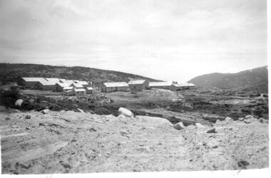
11 Black and White photographs of the Rocky Valley area, c1948
... Photo No. 2 - on the back, printed in ink "Rocky Valley Camp... Scheme Photo No. 1 - on the back, printed in ink"Rocky Valley ...In October 1947 construction was commenced on the erection of the workmen's camp at Rocky Valley. Also in 1947 construction of a stream diversion was commenced to allow excavation to commence for the dam wall. In the summer of 1948/49, stripping of the foundation area on both sides of the river was carried out. Weather conditions were not always favourable during the construction, particularly 1955/56 summer, and work would have to cease each year for the winter season due to the severe conditions. The dam is a earth and rock fill structure with a height of about 30.5 metres and crest length 518.16 metres and was completed in March, 1959.These photographs show the type of terrain in the area prior to the construction and filling of Rocky Valley Dam. Also of interest is the type of accommodation provided for those working on the construction and the early cranes available in the 1940/50's. Of historical importance to understand the conditions in the early construction of the Kiewa Hydro Electric SchemeEleven small black and white photographsPhoto No. 1 - on the back, printed in ink"Rocky Valley - New Mess & offices Dec. 1948". In pencil '14 on the back Photo No. 2 - on the back, printed in ink "Rocky Valley Camp. October 1948". Also stamped on the back "998L" Photo No. 3 -on the back, printed in ink "Rocky Valley Hostel October 1948". Also stamped on the back '998L' Photo No. 4 - on the back, printed in ink "Spion Kopje from bedroom window. October 1948". Stamped on the back '998L'. Photo No. 5 - on the back, printed in ink "Rocky Valley Basin Dec. 1948." In pencil on back, 14. Photo No. 6 - on the back, printed in ink "Site of Wall for Rocky Valley Dam Dec. 1948". In pencil on back, 14. Photo No. 7 - On the back, printed in ink "Commencing of Diversion Tunnel Rocky Valley December 1948". In pencil on back, 14. Photo No. 8 - on the back, printed in ink "One of the two electric cranes at Rocky Valley December 1948". In pencil on back, 14. Photo No. 9 - on the back, printed in ink "'Rapier' (H.Y.) electric crane Rocky Valley December 1948". In pencil on back, 14 . Photo No. 10 - on the back, printed in ink " Pretty Valley Pump line construction Mt. Cope in Background Nov 1948. Circular stamp with the words 'print by Wilson White Albury' in the circle. Photo No. 11 - on the back, printed in ink "Stringing cable on Ruined Castle October 1948. Same stamp as No. 10. In pencil '31'. rocky valley; pretty valley; ruined castle; bogong high plains; kiewa hydro electric scheme -
 Kiewa Valley Historical Society
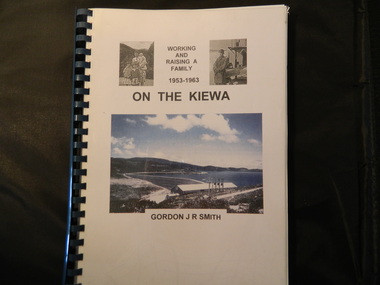
Book - On the Kiewa, Working & Raising a Family 1953 - 1963 by Gordon J. R. Smith, 9th September 2005
... and white photos. Front Cover includes 2 small black and white... and white photos. Front Cover includes 2 small black and white ...Personal account of Gordon Smith's life when living in Mt Beauty and Bogong townships while working for the SECV on the Kiewa Hydro Electric Scheme.Gordon gives an account of both working and living during the 1950s and early 1960s in a remote part of Victoria - the Kiewa Valley and in 2 small construction towns. He gives a lot of detail eg. the weather, his work, the people, the activities, his family and leisure time.Plastic threaded spine holding 282 pages with black and white photos. Front Cover includes 2 small black and white photos either side of the title at the top and below the title a larger colored photo of Rocky Valley Dam. Author's name is underneath. "Dick Puttyfoot" on cover page.kiewa hydro electric scheme, state electricity commission of victoria., gordon smith -
 Kiewa Valley Historical Society
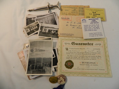
Memorabilia - Matthews Collection
People collect items that help them remember a special time in their lives or some thing that appeals to them. Brownie cameras were used in the 1950s. Negatives and photos represent the life of the Matthews family.George and Laura Matthews lived at 12 Roper St. Mt Beauty from 1957 to the 1970s. The items in this collection belonged to them and represent part of their lives when living in the Kiewa Valley.1. Brownie camera - black vinyl. 2. Tin Box "Ted the Jester' biscuit tin. 3. Gold button & Queen Elizabeth badge 4. Silver plunger 5. Dunkling Jewellers Guarantee re ring 6. State Savings Bank Book 1957 - 1963 7. Laura M. Matthews Union Card 1963 8. LaTrobe Health Service Card. 9. Meat Ration Cards 1948 10. 18 Negatives of people/holidays in envelope 11. Photos1. Made in England by Kodak Ltd 2. Use by 1998 and 'Eileen' printed in texta on top george matthews, laura matthews, 12 roper st., mt beauty, brownie camera -
 Kiewa Valley Historical Society
5 small black and white photos of Clover Dam and Power Station, c1948
... Station Clover Flat Nov. 1948 Photo No. 2 - handwritten in ink... Power Station Clover Flat Nov. 1948 Photo No. 2 - handwritten ...The construction of Clover Power Station was commenced in October 1942 and the power station building was completed in May, 1943. The first machine was placed in service August, 1944 and the second machine in May, 1945. The water discharges directly into Clover Dam and re-used in West Kiewa Station. Clover Dam - stripping of foundation area commenced in January 1948 but the final concrete pour was not until 14th August, 1954.Pictorial history of the early construction undertaken in the building of the Kiewa Hydro Electric Scheme. Clover power station (No. 3 Development) was the first power station to be built .5 small black and white photographsPhoto No. 1 - handwritten in ink on back ' No. 3 Power Station Clover Flat Nov. 1948 Photo No. 2 - handwritten in ink on back 'No. 3 Power Station Clover Flat Nov. 1948 Photo No. 3- handwritten in ink 'Clover Flat looking towards work area of Clover Dam. Taken near #3 PS. Nov. 1948 Photo No 4 - Handwritten in ink 'Preparation for wall of Clover Dam Dec. 1948 Photo No.5 - handwritten in ink 'Preparation for wall o f Clover Dam Dec. 1948. Photo Nos. 1,2 3, on the back have circular stamp with 'Print by Willson White Albury'. In pencil is the number '78'. Photo Nos. 4, 5, have written on the back in pencil, number '14'. construction, clover power station, clover dam, -
 Kiewa Valley Historical Society
Sheets 7 and 8 of a set of 10 sheets of photographs of the Kiewa area, 1948 - 1950's
These photographs are a pictorial and historical record of the photographer, Ronald George Thorn, of his days as an engineer with SECV. He worked in the Kiewa area as a cadet engineer from 1948 to 1950 and then in 1953 to 1956 as an electrical engineer grade 2.The photographs tell the story of one mans involvement in the construction of the Kiewa Hydro Electric Scheme during his employment with the State Electricity Commission of Victoria.A foolscap sized sheet of light weight cardboard with 3 photographs (black and white) adhered to sheet 7 and 8 black and white photos adhered to sheet 8. Number 7 is handwritten in ink on a small square of white paper and adhered to the page by sticky tape. Number 8 is also written as above and adhered to reverse side.engineer, kiewa, secv