Showing 3762 items
matching surveyed
-
 Glen Eira Historical Society
Album - Album page, Glen Eira Road, Circa 1972
This photograph is part of the Caulfield Historical Album 1972. This album was created in approximately 1972 as part of a project by the Caulfield Historical Society to assist in identifying buildings worthy of preservation. The album is related to a Survey the Caulfield Historical Society developed in collaboration with the National Trust of Australia (Victoria) and Caulfield City Council to identify historic buildings within the City of Caulfield that warranted the protection of a National Trust Classification. Principal photographer thought to be Trevor Hart, member of Caulfield Historical Society. Most photographs were taken between 1966-1972 with a small number of photographs being older and from unknown sources. All photographs are black and white except where stated, with 386 photographs over 198 pages. From Glen Eira Heritage Management Plan 1996 by Andrew Ward: Since 1990, valuable historic houses to have been demolished include "Noris", later "Quethiock", and "Koala" (1875) at 34 Balaclava Road, "Urandaline", later Samford private hospital at 510 Glen Eira Road, and No. 9 Lempriere Avenue. When the Caulfield Tramway Company opened its single line horse tramway along Glen Eira Road to Caulfield station in 1889, the eastern end of this road passed through open paddocks and alongside "Urandaline", a charming late Victorian villa residence with comer pinnacle roof, demolished in 1995.Page 59 of Photograph Album with five photographs, one portrait of the exterior of a house on Glen Eira Road, the other four are photos of sections of advertising materials for Urandaline Estate.Hand written: 508 Glen Eira Road [under top left photo] / 58 [bottom left] trevor hart, glen eira road, caulfield north, urandaline, urandaline estate, horse tram, land subdivision, real estate advertising, verandahs -
 Mission to Seafarers Victoria
Painting, WW2 AMS (Corvette): HMAS Rockhampton, early 21st Century
From his obituary published in Optometry Australia: Born in 1925 in Swan Hill, his parents were soldier settlers in the Mallee before moving to Melbourne. After obtaining his leaving certificate from Melbourne Grammar, he worked as a laboratory assistant in an explosives factory but later completed a chemistry diploma. He enlisted in the Navy in 1943 aged 17 years and due to a colour vision deficiency, served in the supply branch on HMAS Rockhampton, being discharged aged 21. His deuteranomaly steered him to learn adaptive behaviours while studying optometry, ensuring his clinical practice remained unaffected.According to wikipedia 2017 : Rockhampton began her career as a convoy escort along the east coast of Australia.[1] Following a series of Japanese submarine attacks along the east coast of Australia, a convoy system was established.[1] Rockhampton and USS Selfridge escorted the first Sydney to Brisbane convoy.[1] The corvette remained in this role until January 1944, when she began escorting convoys to and from New Guinea.[1] She underwent refit in Sydney over April and May 1944, before returning to escort duties in New Guinea waters.[1] Rockhampton operated in both Australian and New Guinea waters up until the end of World War II.[1] Following the end of the war, Rockhampton was involved in the rescue of Dutch and Indonesian prisoners-of-war and the occupation of Ambon.[1] On 8 October 1945, the corvette carried the Sultan of Ternate on his return home.[1] Rockhampton returned to Sydney in November 1945, where she was assigned to minesweeping duties off the east coast of Australia.[1] She later participated in survey duties off the coast of South Australia, before returning to Sydney on 29 April 1946.[1] The corvette received two battle honours for her wartime service: "Pacific 1942–45" and "New Guinea 1944"HMAS Rockhampton launched 1941 and de-commissioned 1946. Operated in the Pacific and New Guinea theatres of WW2 see supplementary files for details Maritime ArtJames CockburnAcrylic painting on composition board of a military or armed corvette at sea. Framed with a speckled pale blue painted moulded pine ? frame. The painting is signed on lower right corner and inscribed with both blue and black fibre tipped pen.Front: lwr right corner: "D Cockburn" in pale blue paint ; Verso "WW2 AMS (Corvette): HMAS Rockhampton / PAINTED BY DAVID M COCKBURN FORMER CREW MEMBER / PH DAVE ..."hmas rockhampton, corvette, ww2, merchant navy, world war 2, david cockburn, crew, sailors, seamen, seafarers, optometrist, artwork-paintings, hobbies -
 Parliament of Victoria
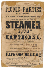
Flyer for the steamer Viva, Abbott & Co., Printers, c.1860
The "Viva" was a steamboat operated by George Dent that ran on the Yarra River between Princes Bridge and Hawthorn Bridge from 1860-1861. Printer flyer pasted onto cardboard advertising ferry services between Melbourne and Hawthorne [sic]. Corrections to ferry departure times are in black handwritten ink. Flyer has losses around edges and stains from 'blue-tack' verso. Black ink, printed recto: "PIC-NIC PARTIES/ AND OTHERS./ A Steamer to Hawthorne Twice a day./ On and after Monday Next, 26th march, the/ STEAMER/ "VIVA"/ Will Run daily, (Sundays Excepted) between Melbourne and/ HAWTHORNE,/ Landing Passengers at Survey Paddock, Gardner's Creek, and/ any other place along the Yarra Banks./ Leavers Hawthorne Bridge 10 a.m./ 2 p.m./ 5.30 p.m./ Leaves Princes' Bridge, melbourne 12 p.m./ 4 p.m./ Fare One Shilling/ EACH WAY./ N.B.-Parties wishing to send packages or parcels by the Steamer th(?).../ will be received and a receipt given at the waiting room, Melbourne, or on board.../ by George Dent, who will execute any orders in Town./ Small Packages, - 6d. Large Packages, - 1s/ Abbot & Co., Printers, Melbourne.viva steamboat, dent, george, hawthorne, yarra river, princes bridge, melbourne, survey paddock, gardner's creek -
 Ringwood and District Historical Society
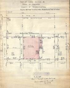
Document, 1926 Land Survey drawing of the area surrounding 1-5 City Road, Ringwood
Drawing on parchmentHand-drawn survey of what is now 1-5 City Road, Ringwood. Drawn by K Arndt, licensed surveyor, 237 Queen Street, Melbourne Tel 5118 on 25 September 1926. The block of land in question was 2 roods, 21 and 8/10 perches in size. The location was between Haig Street in the north, City Road in the south, Wantirna Road in the west and Victoria Road in the east. The Good Shepherd Retirement Village (Lutheran) now occupies the land. The drawing shows a number of existing weatherboard houses, fences and frontage sizes. A number of named roads were defined but no longer exist, these were Duffy Street (to the west), Evans Street (east) and Victoria Street (further east). Ireland Street still exists in the south. -
Federation University Historical Collection
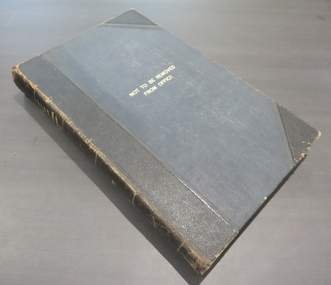
Book - Ledger, Ballarat School of Mines Minutes: 1909-1918, 1909-1918
The Ballarat School of Mines was the first School of Mines in Australia. It is a predecessor institution of Federation University Australia.Hard coveredboob with leather spine and corners. The minites of the Ballarat School of Mines Council are handwrittten on the 25 March 1910 "... It was resolved that in the event of the Department of Forestry offering 250 pounds per annum for the instruction of their students at Creswick in Chemistry, Botany, Physics and Surveying that it be accepted ..." lined pages. 26 November 1909 "..It was decided to accept with thanks an offer of a flagpole and flag made by Mr W. Coltman through the student association. Mr Clegg to be consulted as to its erection. ..." 25 August 1916 "... A very cordial welcome was extended to Colonel Bolton, who was present for the first time since his return from Gallipoli. ... " 25 July 1910 "... A letter was received from the staff in reference to Mr Oddie's system of ventilation which he wishes introduced into the School. It was decided to postpone the matter for consideration when funds are available, ..." "... At Colonel Bolton's suggestion, it was decided to inform the Sectretary of the Returned Soldiers Association that applications from returned soldiers for free instruction at this School would be favorably considered, and that it would be in the best interests of the movement if applications for admission were received through the Association. ... that Councillors T. Hurley, R. Stephenson, Colonel Bolton and the Principals be appointed as a sub-committee with power to act, in dealing with application from Returned Soldiers. "ballarat school of mines, james bickett, richard t. vale, j.k. dunn, s.e. figgis, samuel figgis, j. lonie, r. maddern, j.y. mcdonald, w.h. middleton, d. mitchell, dr morrison, h.a. nevett, j. ssxton, dr scott, w.h. sewell, j. vikery, g.h. fitches, andrew anderson, g. buchanan, j. dunn, f. herman, j. mitchell, r. scott, r.e. williams, j.d. woolcott, j. pearse, james oddie, shackleton polarizer, forestry school, creswick, b. whittington, ida johnson, j. barber, j. foster, h. hall, w.j. humphries, s. flohm, signwriting, frank tate, colonel bolton, j.b. robinson, alexander peacock, h.h. smith, charles fenner, c.a. hoadley, a.w. steane, j.n. dunn, w.d. hill, c. fenner, g. fitches, r. pearse, a.o. stubbs, daniel walker, w. nixon, t. hurley, r. stephenson, a.e. cutter, w.h. flaey, j.w. gower, j.n. montgomery, ballarat school of mines museum, a.m. lilburne, d. maxwell, d. ronaldson, r.e. tunbridge, j. jolly, j.m. sutherland, frederick martell, w.j. hoare, j.j. brokenshire, r. cutter, g. remfry, j.e. molloy, .stewart bequest, h.b. herbert, j. kean, f. saunders, george swinburne, w.j. humphreys, j. stevens, william baragwanath, richard g. walker, j.f. wiles, w.j. parry, george vincent, m.hannah, repatriation, returned soldiers, william k. bolton, maurice copland, d.v. allen, r.f. barker, a.f. heseltine, r.w. richards, appointment of dick richards, j.f.w. sporn, p.g. brown, h. daykin -
 Kew Historical Society Inc
Plan, Melbourne & Metropolitan Board of Works : Borough of Kew : Detail Plan No.1291, 1905
The Melbourne and Metropolitan Board of Works (MMBW) plans were produced from the 1890s to the 1950s. They were crucial to the design and development of Melbourne's sewerage and drainage system. The plans, at a scale of 40 feet to 1 inch (1:480), provide a detailed historical record of Melbourne streetscapes and environmental features. Each plan covers one or two street blocks (roughly six streets), showing details of buildings, including garden layouts and ownership boundaries, and features such as laneways, drains, bridges, parks, municipal boundaries and other prominent landmarks as they existed at the time each plan was produced. (Source: State Library of Victoria). This plan forms part of a large group of MMBW plans and maps that was donated to the Society by the Mr Poulter, City Engineer of the City of Kew in 1989. Within this collection, thirty-five hand-coloured plans, backed with linen, are of statewide significance as they include annotations that provide details of construction materials used in buildings in the first decade of the 20th century as well as additional information about land ownership and usage. The copies in the Public Record Office Victoria and the State Library of Victoria are monochrome versions which do not denote building materials so that the maps in this collection are invaluable and unique tools for researchers and heritage consultants. A number of the plans are not held in the collection of the State Library of Victoria so they have the additional attribute of rarity.Original survey plan, issued by the MMBW to a contractor with responsibility for constructing sewers in the area identified on the plan within the Borough of Kew. The plan was at some stage hand-coloured, possibly by the contractor, but more likely by officers working in the Engineering Department of the Borough and later Town, then City of Kew. The hand-coloured sections of buildings on the plan were used to denote masonry or brick constructions (pink), weatherboard constructions (yellow), and public buildings (grey). A detail plan of part of Studley Park bordered by the major streets of Hodgson Street, Stevenson Street and Studley Park Road. Included on the plan are a number of significant Studley Park mansions in existence at the beginning of the 20th century. The unnamed street shown in the middle of the plan is McEvoy Street. The most important house still extant is Campion House, formerly named Dalsraith [Dalswraith] and Glendalough, owned since the 1940s by the Society of Jesus. Campion House can be seen on the corner of Hodgson and Studley Park Road. Its stables at the rear of the block have now been incorporated into a contemporary residence. An interesting feature of the plan is the 1910 annotation by Ed Seitz, professional designing engineer. Is Seitz the contractor who modified the MMBW original?melbourne and metropolitan board of works, detail plans, mmbw 1291, cartography -
 Kew Historical Society Inc
Plan, Melbourne & Metropolitan Board of Works : Borough of Kew : Detail Plan No.1564, 1905
The Melbourne and Metropolitan Board of Works (MMBW) plans were produced from the 1890s to the 1950s. They were crucial to the design and development of Melbourne's sewerage and drainage system. The plans, at a scale of 40 feet to 1 inch (1:480), provide a detailed historical record of Melbourne streetscapes and environmental features. Each plan covers one or two street blocks (roughly six streets), showing details of buildings, including garden layouts and ownership boundaries, and features such as laneways, drains, bridges, parks, municipal boundaries and other prominent landmarks as they existed at the time each plan was produced. (Source: State Library of Victoria)This plan forms part of a large group of MMBW plans and maps that was donated to the Society by the Mr Poulter, City Engineer of the City of Kew in 1989. Within this collection, thirty-five hand-coloured plans, backed with linen, are of statewide significance as they include annotations that provide details of construction materials used in buildings in the first decade of the 20th century as well as additional information about land ownership and usage. The copies in the Public Record Office Victoria and the State Library of Victoria are monochrome versions which do not denote building materials so that the maps in this collection are invaluable and unique tools for researchers and heritage consultants. A number of the plans are not held in the collection of the State Library of Victoria so they have the additional attribute of rarity.Original survey plan, issued by the MMBW to a contractor with responsibility for constructing sewers in the area identified on the plan within the Borough of Kew. The plan was at some stage hand-coloured, possibly by the contractor, but more likely by officers working in the Engineering Department of the Borough and later Town, then City of Kew. The hand-coloured sections of buildings on the plan were used to denote masonry or brick constructions (pink), weatherboard constructions (yellow), and public buildings (grey). In 1905, when Plan No.1564 was printed, that part of Kew bordered by Brougham Place (now Daniell Place), Mount Street, Sackville Street and Ross Street was already the location of a number of large mansions. Here, subdivisions, at least at this stage, produced larger blocks than in Central Kew. Many of the houses on this plan are named: ‘Faybrook’, ‘Northumbria’, ‘Parkholm[e]’, ‘Dunboe’, ‘Katoomba’ and ‘Eschol’ fronting Sackville Street. Eschol was once the home of the manufacturer Robert Harrison, whose cordial factory in Spring and Argyle Streets Fitzroy are noted on the Victorian Heritage Register. ‘The Hawthorns’ on the corner of Brougham Place and Mount Street was the home of the medical practitioner Frank William Fay, who won the military cross and other honours for conspicuous gallantry and devotion to duty in World War 1.melbourne and metropolitan board of works, detail plans, mmbw 1564, cartography -
 Kew Historical Society Inc
Plan, Melbourne & Metropolitan Board of Works : Borough of Kew : Detail Plan No.1570, 1905
The Melbourne and Metropolitan Board of Works (MMBW) plans were produced from the 1890s to the 1950s. They were crucial to the design and development of Melbourne's sewerage and drainage system. The plans, at a scale of 40 feet to 1 inch (1:480), provide a detailed historical record of Melbourne streetscapes and environmental features. Each plan covers one or two street blocks (roughly six streets), showing details of buildings, including garden layouts and ownership boundaries, and features such as laneways, drains, bridges, parks, municipal boundaries and other prominent landmarks as they existed at the time each plan was produced. (Source: State Library of Victoria)This plan forms part of a large group of MMBW plans and maps that was donated to the Society by the Mr Poulter, City Engineer of the City of Kew in 1989. Within this collection, thirty-five hand-coloured plans, backed with linen, are of statewide significance as they include annotations that provide details of construction materials used in buildings in the first decade of the 20th century as well as additional information about land ownership and usage. The copies in the Public Record Office Victoria and the State Library of Victoria are monochrome versions which do not denote building materials so that the maps in this collection are invaluable and unique tools for researchers and heritage consultants. A number of the plans are not held in the collection of the State Library of Victoria so they have the additional attribute of rarity.Original survey plan, issued by the MMBW to a contractor with responsibility for constructing sewers in the area identified on the plan within the Borough of Kew. The plan was at some stage hand-coloured, possibly by the contractor, but more likely by officers working in the Engineering Department of the Borough and later Town, then City of Kew. The hand-coloured sections of buildings on the plan were used to denote masonry or brick constructions (pink), weatherboard constructions (yellow), and public buildings (grey). Plan No.1570 shows the layout of gardens and houses in Sackville Street, Davis Street, Wrixon Street, and Fitzwilliam Street in 1904. While Thomas Street is included on the map, at this stage no houses had been built. The plan identifies two named houses: ‘Fairview’ and ‘Kylemore’. Fairview is more fully delineated in Plan No.1563. Kylemore is one of the few houses in Kew designed by John Beswicke. The most notable owner of Kylemore was William Whitehead, who owned the house between 1895 and 1900. In 1894, Australian newspapers reported the marriage of Whitehead’s daughter to Dr. Gerald Eugene Cussen, the brother of Sir Leo Cussen, the Supreme Court Judge. The married couple was to live at ‘Wilton’ (now the Kew RSL) from 1911-15.melbourne and metropolitan board of works, detail plans, mmbw 1570, cartography -
 Kew Historical Society Inc
Plan, Melbourne & Metropolitan Board of Works : Borough of Kew : Detail Plan No.1572, 1905
The Melbourne and Metropolitan Board of Works (MMBW) plans were produced from the 1890s to the 1950s. They were crucial to the design and development of Melbourne's sewerage and drainage system. The plans, at a scale of 40 feet to 1 inch (1:480), provide a detailed historical record of Melbourne streetscapes and environmental features. Each plan covers one or two street blocks (roughly six streets), showing details of buildings, including garden layouts and ownership boundaries, and features such as laneways, drains, bridges, parks, municipal boundaries and other prominent landmarks as they existed at the time each plan was produced. (Source: State Library of Victoria)This plan forms part of a large group of MMBW plans and maps that was donated to the Society by the Mr Poulter, City Engineer of the City of Kew in 1989. Within this collection, thirty-five hand-coloured plans, backed with linen, are of statewide significance as they include annotations that provide details of construction materials used in buildings in the first decade of the 20th century as well as additional information about land ownership and usage. The copies in the Public Record Office Victoria and the State Library of Victoria are monochrome versions which do not denote building materials so that the maps in this collection are invaluable and unique tools for researchers and heritage consultants. A number of the plans are not held in the collection of the State Library of Victoria so they have the additional attribute of rarity.Original survey plan, issued by the MMBW to a contractor with responsibility for constructing sewers in the area identified on the plan within the Borough of Kew. The plan was at some stage hand-coloured, possibly by the contractor, but more likely by officers working in the Engineering Department of the Borough and later Town, then City of Kew. The hand-coloured sections of buildings on the plan were used to denote masonry or brick constructions (pink), weatherboard constructions (yellow), and public buildings (grey). Plan No. 1572 represents the built environment bordered by Barkers Road, Wrixon Street, Edgevale Road and Fitzwilliam Street. Other streets identified on the plan include Stansell Street. Plan 1572 shows that by 1903-05, there was only patchy development in this area of Kew, mainly on Edgevale Road and Fitzwilliam Street. Only two named houses are identified: the quaintly named ‘Tweed Cottage’, and ‘Mendip’. The earliest reference to Treed Cottage in Australian newspapers is to the death of Walter Thompson, aged 74 who was a resident there in 1885. His youngest daughter was to die there in 1908. Mendip to the north of Tweed Cottage was owned by Henry Thompson; he was to die in 1901; his wife in 1932. At this period of time, Malin Street and Clivedon Court did not extend to Barkers Road.melbourne and metropolitan board of works, detail plans, mmbw 1572, cartography -
 Kew Historical Society Inc
Plan, Melbourne & Metropolitan Board of Works. Borough of Kew Detail Plan No.1579, 1904
The Melbourne and Metropolitan Board of Works (MMBW) plans were produced from the 1890s to the 1950s. They were crucial to the design and development of Melbourne's sewerage and drainage system. The plans, at a scale of 40 feet to 1 inch (1:480), provide a detailed historical record of Melbourne streetscapes and environmental features. Each plan covers one or two street blocks (roughly six streets), showing details of buildings, including garden layouts and ownership boundaries, and features such as laneways, drains, bridges, parks, municipal boundaries and other prominent landmarks as they existed at the time each plan was produced. (Source: State Library of Victoria). This plan forms part of a large group of MMBW plans and maps that was donated to the Society by the Mr Poulter, City Engineer of the City of Kew in 1989. Within this collection, thirty-five hand-coloured plans, backed with linen, are of statewide significance as they include annotations that provide details of construction materials used in buildings in the first decade of the 20th century as well as additional information about land ownership and usage. The copies in the Public Record Office Victoria and the State Library of Victoria are monochrome versions which do not denote building materials so that the maps in this collection are invaluable and unique tools for researchers and heritage consultants. A number of the plans are not held in the collection of the State Library of Victoria so they have the additional attribute of rarity.Original survey plan, issued by the MMBW to a contractor with responsibility for constructing sewers in the area identified on the plan within the Borough of Kew. The plan was at some stage hand-coloured, possibly by the contractor, but more likely by officers working in the Engineering Department of the Borough and later Town, then City of Kew. The hand-coloured sections of buildings on the plan were used to denote masonry or brick constructions (pink), weatherboard constructions (yellow), and public buildings (grey). While MMBW Plan No.1579 does not include many buildings, those that it does show are significant to Kew’s history. These include the ‘Kew [Railway] Station’ in Denmark Street and the ‘Recreation Hall’ and rear courts off Wellington Street. The plan shows the outline of the Recreation Hall, constructed in 1880, at the rear of which is listed a bowling green, two tennis courts, a ‘skittle alley’ and a pavilion. When the Hall was first built, the Kew Cricket Club occupied an adjacent ground, however in 1885 this was acquired by the State Government as the future location of the Kew Railway Station. The Plan also shows a single oval at Xavier College. This oval was completed in 1883. One of the current ovals conforms to this oval’s original shape and position in the school grounds.melbourne and metropolitan board of works, detail plans, maps - borough of kew, mmbw 1579, cartography -
 Kew Historical Society Inc
Plan, Melbourne & Metropolitan Board of Works / Borough of Kew, Detail Plan No.1593, 1905
The Melbourne and Metropolitan Board of Works (MMBW) plans were produced from the 1890s to the 1950s. They were crucial to the design and development of Melbourne's sewerage and drainage system. The plans, at a scale of 40 feet to 1 inch (1:480), provide a detailed historical record of Melbourne streetscapes and environmental features. Each plan covers one or two street blocks (roughly six streets), showing details of buildings, including garden layouts and ownership boundaries, and features such as laneways, drains, bridges, parks, municipal boundaries and other prominent landmarks as they existed at the time each plan was produced. (Source: State Library of Victoria)This plan forms part of a large group of MMBW plans and maps that was donated to the Society by the Mr Poulter, City Engineer of the City of Kew in 1989. Within this collection, thirty-five hand-coloured plans, backed with linen, are of statewide significance as they include annotations that provide details of construction materials used in buildings in the first decade of the 20th century as well as additional information about land ownership and usage. The copies in the Public Record Office Victoria and the State Library of Victoria are monochrome versions which do not denote building materials so that the maps in this collection are invaluable and unique tools for researchers and heritage consultants. A number of the plans are not held in the collection of the State Library of Victoria so they have the additional attribute of rarity.Original survey plan, issued by the MMBW to a contractor with responsibility for constructing sewers in the area identified on the plan within the Borough of Kew. The plan was at some stage hand-coloured, possibly by the contractor, but more likely by officers working in the Engineering Department of the Borough and later Town, then City of Kew. The hand-coloured sections of buildings on the plan were used to denote masonry or brick constructions (pink), weatherboard constructions (yellow), and public buildings (grey). The laborious task of hand-tinting these Board of Works plans was not without hazards as is evidenced by Plan No. 1593. On the Plan, the original colourist spilt black and green ink, partially obscuring some parts. The most obvious casualty is ‘Clifton’ located on the corner of Cotham Road and Park Street [now Adeney Avenue]. Included in this Plan, and outlined in pink is that part of the section that the contracting engineer was tasked with completing. This included sewering on both sides of this part of Cotham Road, but excluded properties such as ‘Glendonald’ and ‘Monnington’. This area was to undergo a series of subdivisions including the ‘Clifton Estate’, which created housing lots on Adeney Avenue and Florence Avenue in 1916. The most notable occupant of Clifton was William Adeney [died 1893], a pioneer of Camperdown, after which Park Street was later renamed.melbourne and metropolitan board of works, detail plans, survey plans - borough of kew, mmbw 1593, cartography -
 Bendigo Military Museum
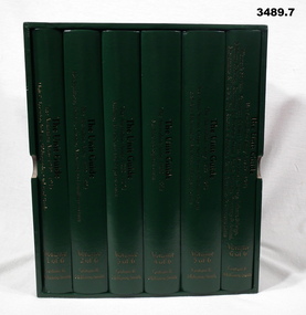
Book - BOOKS, BOXED SET, Graham R McKenzie - Smith, The Unit Guide, 2018
.1) Box open, cardboard, dark green buckram, white paper lining, gold print on sides. .2) - .7) Hard cover book, cardboard, dark green buckram with gold print on front cover & spine. Pages are plain, cut, white, black print, black & white illustrations. .2) Volume 1 of 6. Unit & Location Indexes / Bibliography, Orders of Battle. 483 pages. .3) Volume 2 of 6. Headquarters, Infantry, Cavalry / Armoured & Intelligence Units. 605 pages. .4) Volume 3 of 6. Artillery, Air Defence and Engineer Units. 626 pages. .5) Volume 4 of 6. Medical and Signal Units. Box of 6 books. The Unit Guide / The Australian Army / 1939 - 1945. 654 pages .6) Volume 5 of 6. Aust Army Service Corps, Aust Army Ordnance Corps and Aust Electrical & Mechanical Engineer Units. 706 pages. .7) Volume 6 of 6. Womens Services / Volunteer Defence Corps / War Graves, Survey, Labour, Salvage / Military Policing / Recruiting & Training / Dental, Bath & Laundry / Veterinary & Animal / Movements & Transit / Pay, Records & Printing, Postal / Amenities & Canteens Units. 568 pages. books- military history, unit guide -
Melbourne Tram Museum
Newspaper, The Age, “Millions in bonuses despite repeated train, tram delays”, 4/01/2019 12:00:00 AM
Newspaper clipping titled: “Millions in bonuses despite repeated train, tram delays” Newspaper clipping from the Age 4/1/2019 Transport reporter - Timna Jacks Photo of tram travelling under rail bridge Yarra trams awarded $1.26M in bonuses (potentially up to $5.5M) despite failing to meet on-time performance targets 5 times. Failed to meet its new 82% punctuality target (up from 77%) in 5 of past 12 months. Fined more than $300K in penalties. Both public transport operators won 7 year contracts in 2017. Tram route 86 has lowest punctuality (75.1%), more than 6500 services short shunted (7.5% of all services). Government says tram performance has improved overall due to tougher targets. Customer surveys show 15% drop in complaints to Yarra Trams. Trams - least punctual: Route 86 - 75.1%, route 70 - 77.5%, route 75 - 78.9% Trams - most punctual: Route 82 - 91.1%, route 78 - 89.5%, route 57 - 86.6% Trams - worst for short shunts: Route 70 - 8%, route 86 - 7.5%, route 16 - 7.3%trams, tramways, yarra trams, delays, public transport -
 Melbourne Tram Museum
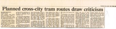
Newspaper, The Age, "Planned cross - city tram routes draw criticism", "Coalition pledges efficiency review of tramways plan", "System hit by years of Neglect" "A new tramway game of nought's and crosses", 14/06/1992 12:00:00 AM
Set of three Newspaper clippings about the proposed cross linking of Melbourne tram routes, written by Jacqui Macdonald and Claude Forrell. .1 - The Age, 30/6/1992 - by Jacqui Macdonald, titled "Planned cross - city tram routes draw criticism", PTC review, W class trams, conductors, PTUA Patrick O'Connor, National Trust David Clark, Opposition Alan Brown and Peter Spyker all commented. Noted by one body a lack of research and surveys. .2 - The Age 1/7/1992 - two items - "Coalition pledges efficiency review of tramways plan", about the plan prepared by the Strategic Review Committee chaired by Peter Parkinson, workplace reforms, cross linking of tram routes, release of the review report the previous day by Peter Spyker. Also quotes Union Secretary Lou DiGregorio and PTUA. The second item - "System hit by years of Neglect" - comments about the report and The Met ticket dispute. Item has a map showing the proposed routes. .3 - The Age 1/7/1992 - "A new tramway game of nought's and crosses" - Claude Forrell - looking at the savings of the plan, conductors, union consent, Government and Coalition attitudes to the proposal of cross linking routes. finances.trams, tramways, operations, transport, public transport, unions, finances, maps, tram routes, w class, national trust, ptua, conductors -
 Federation University Historical Collection
Books, H.E. Daw Government Printer, Ballarat School of Mines and Industries Departmental Papers, 1914-1950
Used at the Ballarat School of Mines and the Ballarat Technical Art SchoolThis collection of examinations is significant because of its completeness with the full range of examinations between 1914 and 1950.Large leather bound books, with leather spine, containing all examinations held at the Ballarat School of Mines (including the Ballarat Technical Art School and Ballarat Junior Technical School). The examination papers were supplied and printed by the Education Department, Victoria. Examinations include: Agriculture, Algebra, Architecture, Arithmetic, Applied Mechanics, Assaying, Biology, Botany, Boilermaking, Building Design, Blacksmithing, Bricklaying, Carpentry and Joinery, Coachbuilding, Cabinet Making, Civil Engineering, Cabinet Making, Commercial, Chemistry, Engineering Drawing, Economics, English, Electrical technology, Electricity and Magnetism, Electric Wiring, Electric Welding, Electrical Fitting, Electrical Trades, Food Analysis, Geology, Geological Mapping, Graphics, Geometry, Heat Engines, Heat Treatment, Hydraulics, Hand Railing, Instrument Making, Millinery, Milling and Gearouting, Machine Shop Practice. Metal Founding, Mining, Metallurgy, Mineralogy, Mathematics, Motor Mechanics, Mine Surveying, Mining Mechanics, Petrology, Physics, Painting and Decorating, Pattern Making, Plastering, Plumbing and Gasfitting, Printing, Refrigeration, Spelling, Science , Shorthand, Surveying. Signwriting. Sheet Metalwork, Toolmaking, Ladies Tailoring, Trigonometry, Typewriting, Welding, Commercial Geography. Millinery, Dressmaking, Needlework, Decorative Needlework, Architecture, Building Design and Construction, Art (Composition in Form and Colour), Art (Casting Clay MOdels) Art (Drapery), Art (Drawing the Human Figure From Casts), Art (Drawing the Antique from Memory), Art (Drawing from Memory); Art (Drawing Plant Forms from Nature, Art (Drawing Plant Forms From Memory), Art (Drawing from Models and Objects), (Drawing From a Flat Example). Art (Drawing in Light and Shade from a Cast of Ornament or Lower Nature), Art (Drawing Ornament from the Cast), Art (Drawing from Models or Objects), Art (Drawing fro Dressmakers' and Milliners' Fashions), Art (Drawing With the Brush), Art (Drawing from a Flat Example); Art (Modelled Design), Art (General Design), Art (Embossed Leatherwork), Art (Practical Plane Geometry), Art (Practical Solid Geometry), Art (Geometrical Drawing), Carpentry and Joinery, Art (Human Anatomy), Art (Historic Ornament), Art (House Decoration), Art (LEttering), Signwriting, Art (Light Metalwork), Art (Modelling), Art (Modelling the Human Figure from a Life), Art (Stencilling); Art (Wood Carving) Refrigeration, Teaching, Boilermaking, Blacksmithing, Carpentry and Joinery, Coachbuilding and Carriage Drafting, Electric Wiring, Electrical Fitting, Graining and Marbling, Instrument Making , Machine Shop Practice, Metal Founding, Milling and Gear Cutting, Motor Mechanics, Painting and Decorating, Sheet Metalwork, Toolmaking, Printing, Pattern Making, Plumbing and gasfitting, examinations, ballarat school of mines, ballarat technical art school, trades, education department victoria, agriculture, algebra, architecture, arithmetic, applied mechanics, assaying, biology, botany, boilermaking, building design, blacksmithing, bricklaying, carpentry and joinery, coachbuilding, cabinet making, civil engineering, commercial, chemistry, engineering drawing, economics, english, electrical technology, electricity and magnetism, electric wiring, electric welding, electrical fitting, electrical trades, food analysis, geology, geological mapping, graphics, geometry, heat engines, heat treatment, hydraulics, hand railing, instrument making, millinery, milling and gearouting, machine shop practice, metal founding, mining, metallurgy, mineralogy, mathematics, motor mechanics, mine surveying, mining mechanics, petrology, physics, painting and decorating, pattern making, plastering, plumbing and gasfitting, printing, refrigeration, spelling, science, shorthand, surveying, signwriting, sheet metalwork, toolmaking, ladies tailoring, trigonometry, typewriting, welding., dressmaking, needlework, decorative needlework, architecture, building design and construction, art (composition in form and colour), art (casting clay models), art (drapery), art (drawing the human figure from casts), art (drawing the antique from memory), art (drawing from memory), art (drawing plant forms from nature, art (drawing plant forms from memory), art (drawing from models and objects), (drawing from a flat example), art (drawing in light and shade from a cast of ornament or lower nature), art (drawing ornament from the cast), art (drawing from models or objects), art (drawing for dressmakers' and milliners' fashions), art (drawing with the brush), art (drawing from a flat example), art (modelled design), art (general design), art (embossed leatherwork), art (practical plane geometry), art (practical solid geometry), art (geometrical drawing), art (human anatomy), art (historic ornament), art (house decoration), art (lettering), art (light metalwork), art (modelling), art (modelling the human figure from a life, art (stencilling), art (wood carving), teaching, coachbuilding and carriage drafting, graining and marbling, milling and gear cutting, commercial geography, exams, examination book -
 Kew Historical Society Inc
Plan, Melbourne & Metropolitan Board of Works : Borough of Kew : Detail Plan No.1301, 1910
The Melbourne and Metropolitan Board of Works (MMBW) plans were produced from the 1890s to the 1950s. They were crucial to the design and development of Melbourne's sewerage and drainage system. The plans, at a scale of 40 feet to 1 inch (1:480), provide a detailed historical record of Melbourne streetscapes and environmental features. Each plan covers one or two street blocks (roughly six streets), showing details of buildings, including garden layouts and ownership boundaries, and features such as laneways, drains, bridges, parks, municipal boundaries and other prominent landmarks as they existed at the time each plan was produced. (Source: State Library of Victoria)This plan forms part of a large group of MMBW plans and maps that was donated to the Society by the Mr Poulter, City Engineer of the City of Kew in 1989. Within this collection, thirty-five hand-coloured plans, backed with linen, are of statewide significance as they include annotations that provide details of construction materials used in buildings in the first decade of the 20th century as well as additional information about land ownership and usage. The copies in the Public Record Office Victoria and the State Library of Victoria are monochrome versions which do not denote building materials so that the maps in this collection are invaluable and unique tools for researchers and heritage consultants. A number of the plans are not held in the collection of the State Library of Victoria so they have the additional attribute of rarity.Original survey plan, issued by the MMBW to a contractor with responsibility for constructing sewers in the area identified on the plan within the Borough of Kew. The plan was at some stage hand-coloured, possibly by the contractor, but more likely by officers working in the Engineering Department of the Borough and later Town, then City of Kew. The hand-coloured sections of buildings on the plan were used to denote masonry or brick constructions (pink), weatherboard constructions (yellow), and public buildings (grey). Throughout its history, the land in what is known today as Studley Ward of the City of Boroondara has been subject to continuing subdivision. This is evident in Plan 1301, where later hands have modified the original map to include streets created subsequent to the printing of the plan in 1904. Other annotations such as the ‘Reserved for Road Purposes’ beside the Yarra never eventuated. The plan continued to be modified to at least 1953, when a later hand noted that a particular site was ‘Property site P. McIntyre house’ in Swinton Avenue. Two significant houses in the area are outlined on the plan: ‘Swinton’ on the corner of the streets then named Effey and Maud Streets (now Swinton Avenue) and ‘Fairhaven’ [unnamed] in Stevenson Street. The gardens of the two David Syme owned mansions of ‘Blythswood’ and ‘Rockingham’, stretching down to the River Yarra, are also represented.melbourne and metropolitan board of works, detail plans, mmbw 1301, cartography -
Southern Sherbrooke Historical Society Inc.
Information folder - Helen Gibson
Folder containing information pertaining to Helen Alice Gibson. Contents: -obituary, "One of the world's true givers", Trader Mail, 9 Oct 2007, 2 copies -obituary, "Farewell to history buff and author", Free Press, 10 Oct 2007 -obituary, "Committed to childcare and nature", Age, 29 November 2007 -draft and finished copy of obituary as submitted to above newspapers by Southern Sherbrooke Historical Society -memorial tribute, Sue Buchanan, 2 copies -memorial tribute, Nancy Wallace, 2 copies -memorial tribute, Barbara McLaughlin, 2 copies -memorial tribute, Sue Prentice, 2 copies -photo, Helen Gibson and baby, colour, copy -letter, Jon Pinniger to Marian Matta, dated 2 November 2007, handwritten -typescript, "Thomas Wilkinson Pinnger", biography written by Helen Gibson, undated -article, "Plaque to honour government surveyer T W Pinniger", Traverse, April 200 (journal of Surveyors Australia), 2 pages, copy (above three items all from Jon Pinniger, Gibson relative) -Museum catalogue worksheets describing various items owned by Helen -"With thanks" card (torn in half) with list of games, etc. in Helen's handwriting -Small notebook with loose papers inside, various notes, addresses, etc. -
 City of Moorabbin Historical Society (Operating the Box Cottage Museum)
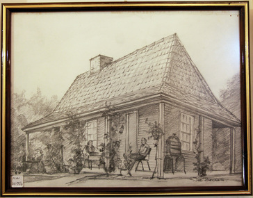
Drawing, charcoal of reconstructed Box Cottage c 1985, c1985
The original small, pioneer cottage was built in the late 1840s to early1850s, by an unknown pioneer. It was located on part of a 30 Acre allotment that was originally part of Dendy’s Special Survey granted in 1841. The doors and window sashes, (made of red deal joinery timber), as well as the brass locks and fittings, are from the original cottage, and were imported from England. The fire-place bricks are from the original cottage, and are sun-dried, (not kiln fired), and are hand-made. Convict marks can be seen on two bricks. There is a small display of external cladding shingles from the original pioneer cottage. These shingles were hand-split, and most likely made from locally collected timber The nails included in this display were used to fasten the shingles on the original cottage, and are also hand-made. The enamel nameplate, “Colonial”, on the wall of the cottage, was the name chosen for the original pioneer cottage when Mr August Reitman, a sculptor, began leasing the property in 1917. August purchased the property c 1935, for 1200 Pounds approximately and resided there until 1953.. In 1974 Mr Lewis, a timber specialist, found the dilapidated building on property he had recently purchased in Jasper Rd and suggested it be reconstructed and relocated. Moorabbin Council agreed and the cottage was rebuilt just about 250 metres from its original site. The cost of the rebuild was met by 'Victoria's 150th Committee, plus a small grant from the City of Moorabbin, and Mr Laurie Lewis donated much of the timber for the reconstruction. A charcoal drawing of the reconstructed 'Box Cottage', in a wooden frame with glass, by Joe Becker c 1985signed : Joe Beckerbox cottage reconstruction, moorabbin, ormond, box william, box elizabeth, brighton, pioneers, market gardeners -
 City of Moorabbin Historical Society (Operating the Box Cottage Museum)
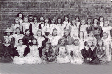
Photograph - Black & White East Bentleigh State School No 2083 c1900, c2005
Early settlers established market gardens, farms and business in the East Brighton ( East Bentleigh) area of Henry Dendy's Special Survey 1841 Brighton. The small communities established Churches and Schools. The Church of England opened St Stephen's Common School c 1850 in Tucker Road with 26 pupils. When the Government School opened 1878 the pupils were transferred to the new Centre Road building and it served the developing East Bentleigh Community until 1990. East Bentleigh State School no. 2083, Centre Road 1878 was closed c1990 due to the dwindling number of pupils enrolling following development of Valkstone SS East Bentleigh, Ormond East SS ( now McKinnon SS) and Tucker Road SS East Bentleigh Names of Pupils inscribed on back of original photograph show the children of the early settler families in Moorabbin Shire Back Row -Bessie long, Ruby Marriott, Irene Peterson, Jessie Gebuer, Grace Reid, Ella Marriott, Daisy Arnold, Lucy Hosking 2nd standing - Edie Roberts, Daisy Marriott, Elsie Strack, Ida Gouruly, Ephanie Bruce, Emma Thompson, Evelyn Marriott, Sarah Jackson, Lola G. 3rd kneeling - Lily Moore, Lizzie Sharman, Mag. Scotland, Em Ray, Elsie Claydon, Lily Marriott, ?? Day, ,Bessie Brewster, Eva Lindberg Front- Florrie D......ieson, Florrie ...i....ade, Ruth Goodrich, Lily Boles, Ettie Arnold, Bessie Marriott, Amie Jackson, Eileen Hosking The Government School opened 1878 in the new Centre Road building near Tucker Road, and it served the developing East Bentleigh Community until 1990. East Bentleigh State School no. 2083, Centre Road 1878 was closed c1990 due to dwindling number of pupils following development of Valkstone SS East Bentleigh, Ormond East SS ( now McKinnon SS) and Tucker Road SS East Bentleigh all situated along or near Tucker Road. Black & White photograph, reproduced c2005., of girl pupils at East Bentleigh State School 2083 c 1900east bentleigh state school no.2083c1900, marriott john, box jessie, pederson vic, long bessie, wong george, shephard hilda, mcneil annie, smith j l; smith mary ann, stanley helen, smith vic, smith harry redvers, chaff cutter, horse drawn carts, toll gates brighton, motor cars 1900, steam engines, early settlers, bentleigh, mckinnon, parish of moorabbin, city of moorabbin, county of bourke, moorabbin roads board, shire of moorabbin, henry dendy's special survey 1841, were j.b.; bent thomas, o'shannassy john, king richard, charman stephen, highett william, ormond francis, maynard dennis, market gardeners, vineyards, orchards -
 City of Moorabbin Historical Society (Operating the Box Cottage Museum)
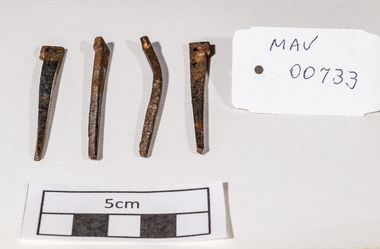
Building Equipment, original hand made nails Box Cottage c 1850, c1850
The original small, pioneer cottage was built in the late 1840s to early1850s, by an unknown pioneer. It was located on part of a 30 Acre allotment that was originally part of Henry Dendy’s Special Survey granted in 1841. The doors and window sashes, (made of red deal joinery timber), as well as the brass locks and fittings, are from the original cottage, and were imported from England.The fire-place bricks are from the original cottage, and are sun-dried, (not kiln fired), and are hand-made. Convict marks can be seen on two bricks.There is a small display of external cladding shingles from the original pioneer cottage. These shingles were hand-split, and most likely made from locally collected timber The nails included in this display were used to fasten the shingles on the original cottage, and are also hand-made. The enamel nameplate, “Colonial”, on the wall of the cottage, was the name chosen for the original pioneer cottage when a later owner, Mr August Rietman and wife Frieda leased the property in around 1917. August purchased the property 1935 for 1200 Pounds approximately and resided there until 1953. In 1974 Mr Lewis, a timber specialist, found the dilapidated building on property he had recently purchased in Jasper Rd and suggested it be reconstructed and relocated. Moorabbin Council agreed and the Cottage was rebuilt just about 250 metres from its original site. The cost of the rebuild was met by 'Victoria's 150th Committee', plus a small grant from the City of Moorabbin, and Mr Laurie Lewis donated much of the timber for the reconstruction. Theses 4 iron nails were hand made by an early settler c1850, using iron, forge and anvil, for the construction of the original Box Cottage 4 hand made iron nails c1850 used in building the original pioneer cottage now known as Box Cottage Museumbox william, box elizabeth, brighton, henry dendy special survey 1841, early settlers, pioneers, moorabbin, box cottage museum, nails, building equuipment, forges, anvils, blacksmiths -
 The Beechworth Burke Museum
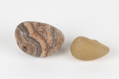
Geological specimen - Agate and Quartz pebbles
Agate occurs when amygdales (gas pockets) form in the upper levels of basaltic lava flows. If these pockets or bubbles are iniltrated by water bearing silica in solution, the fluid dries and hardens in layers, forming round or egg shaped nodules or geodes within the rocky matrix. Agate is formed of a silica mineral chalcedony similar to quartz. Although relatively common and semi-precious, agate has been prized since at least 1450 BC - an intricately carved agate seal was found in the 2015 excavation of a grave belonging to a Mycenaeum priest or warrior near Pylos in Greece. Agate is also used in jewellery and other decorative or ritual purposes due to its often striking appearance. Quartz is found all over Australia, including Beechworth in Victoria. It is formed in deep-seated igneous rocks and crystallized through hot aqueous solutions. It can have two forms; Microcrystalline quartz or Crystalline quartz. Microcrystalline quartz is a fine grain quartz where crystalline quartz is often a large crystal. The colour of quartz can vary. These specimens were collected in Victoria in the vicinity of the Burke Museum. Victoria and other regions of Australia were surveyed for sites of potential mineral wealth throughout the 19th Century. The identification of sites containing valuable commodities such as gold, iron ore and gemstones in a locality had the potential to shape the development and history of communities and industries in the area. The discovery of gold in Victoria, for instance, had a significant influence on the development of the area now known as 'the goldfields', including Beechworth; the city of Melbourne and Victoria as a whole.The specimens are significant as examples of surveying activity undertaken to assess and direct the development of the mineral resource industries in Victoria and Australia, as well as the movement to expand human knowledge of earth sciences such as mineralogy and geology in the nineteenth century.Geological specimens of Agate and Quartz respectively; the fist-sized piece of Agate has peach/coral colouring with grey concentric patterning and the smaller piece of quartz is a uniform yellow/orange shade. Existing label: Local pebbles / (agate and / quartz / (yellowish) / egg-shaped). / BB geological specimen, geology, geology collection, burke museum, beechworth, agate, quartz, north-east victoria, indigo shire, geological surveys -
 Victoria Police Museum
Police Stations (Apollo Bay)
Apollo Bay is a coastal town in southwestern Victoria. It is situated on the eastern side of Cape Otway, along the edge of the Barham River and on the Great Ocean Road, in the Colac Otway Shire. The original township was surveyed in 1853 and named Middleton. In 1881 the town was renamed Krambruk which was changed to Apollo Bay in 1898. The Krambruk Police Station was opened on 7 March 1888 in the Southern District on land opposite the site of the current Mechanics' Institute and changed its name to the Apollo Bay Police Station on 1 September 1990. It came under the Barwon District in 1948 and "Lima" Western District from 4 March 1990. In 1930 the police station was located to 29 Nelson Street. It was a seven-roomed weather-board dwelling on three-quarters of an acre of land. It consisted of six rooms of pine, lined and painted; one pantry; one bathroom and wash-house; one hall; one office and one W.C.. There was stabling for one horse and one cell for prisoners. It was staffed by one Mounted Constable. In the early 1970s land was acquired at 31 Nelson Street and a new police station was constructed. This was a three-roomed brick building with a cell block at the rear. By the time it closed in 2005 it had been extended twice. On 17 November 2006 the current Apollo Bay Police Station opened in its current location at 35a Nelson Street, on the corner of Cartwight Street). Outside the peak summer season, the station is open 16 hours per day and staffed by one sergeant and five other members. 3 black & white photos and 2 coloured photospolice stations; apollo bay police station -
 Federation University Art Collection
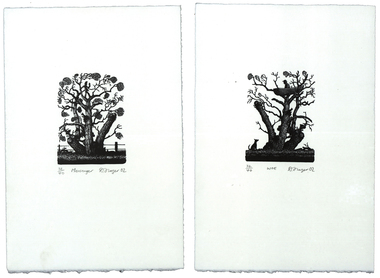
Print - Artwork - printmaking, 'Messenger' and 'Woe' by David Frazer, 2002
David FRAZER (1966- ) Born Foster, Victoria, Australia David Frazer works in painting, wood engraving, etching, lithography and bronze. He studied a B.A. Fine Arts (Painting) at Phillip Institute of Technology, followed by a Diploma of Education (Secondary- Art/Craft) at Latrobe University in 1991. He completed an Honours Degree in Fine Art (Printmaking (at Monash University in 1996, and between 1998 and 2000 Frazer undertook a Master of Arts (Visual Arts) by research: “Pastoral Melancholia”, at Monash University. One of Austalia's foremost printmakers David Frazer's highly detailed woodblock and linocut prints often explore the emotional and fragile state of the human condition. His work offers a nostalgic image of Australia through its examinations of landscape, Australian buildings, sheds, and itinerant travellers. He has held seven solo exhibitions between 1996-2006 in Melbourne, Sydney and a survey show curated by the Horsham Gallery, which toured Victorian regional galleries from 2004-2005. David Frazer’s work was seen in 37 group exhibitions between 1996-2006 including the 5th British International Miniature Print Exhibition in the UK, in the 2003. He more recently held a solo exhibition with Rebecca Hossack in London 2011. (http://www.thestockrooms.com/, accessed 06/03/2015) David was awarded the Keith Wingrove Bookplate Design and in 2002. These two wood engravings are the subject of the forthcoming Private Press book: ‘The Bookplates of David Frazer’ written by Robert C. Littlewood, The Lytlewode Press, Chateau Bosgouet, Normandie, France, 2014/2015. Two limited edition prints by David Frazer using the wood engraving technique. They have been framed together. .1) Messenger Wood Engraving Plate 10.0cm x 7.5cm Paper 29.0cm x 19.3cm Edition: 32/40 .2) Woe Wood Engraving Plate 10.0cm x 7.5cm Paper 29.0cm x 19.3cm Edition: 32/40 Donated through the Australian Government Cultural Gifts Programme by Katherine N. Littlewood, 2014artist, artwork, frazer, david frazer, wood engraving, framed bookplate, printmaking, bookplates, churchill, gippsland campus -
 Uniting Church Archives - Synod of Victoria
Photograph, David Jamieson, editor of Ringwood Parish quarterly magazine "Insight", 06/1984
Jamieson's comments appear in an article surveying the Uniting Church, 7 years after union. "One member who disagrees with the church presents social justice issues is David Jamieson, who has been editor of the Ringwood parish quarterly magazine "Insight" since union. Mr Jamieson says he knows scores of people who find it very hard to accept what he considers is a bias in the presentation of social justice issues. 'I know a lot of people who are becoming alienated because they feel their side of the story is not being presented by the church. They feel only the radical side of justice issues is being hammered. I think the more conservative side has validity. My main concern is the flood of study booklets and material on social justice issues which look at them from only one angle. The bias is on greed, excessive profits and most unworthy aspects of the multi-nationals compared with the most humanitarian concerns of the left. No mention is made of humanitarian concern by big business or the extremes of the left — such as unwarranted industrial action and the effect that this has on the poor and unemployed. No mention is made of excessive wage demands by highly paid people who are pressuring for bigger flow-ons. ….. I do not believe the church should be neutral on political issues. In fact I agree with nearly all of its stands. But we should look at both sides before making up our minds. Only then should we be vocal in a political sense, no matter how one-sided."Full face, looking intently at the camera.C&N identification.jamieson, david, church union 7th anniversary, social justice -
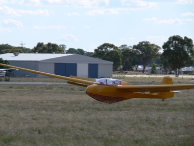 Australian Gliding Museum
Machine - Glider - Sailplane, 1961
The Scheibe Bergfalke II is a high performance (for its day) and relatively inexpensive two seat sailplane designed by Egon Scheibe. It appeared in 1953 as a derivative of the Scheibe Mu13 Bergfalke and incorporated design changes to resolve and simplify structural issues that affected the Mu13. The Bergfalke II-55 followed in 1955. About 300 of the Bergfalke II and II-55 types were built in Germany and Sweden. This aircraft of the Bergfalke II-55 type was built by Scheibe in 1961 (work number 339). After a long life at Fliegergruppe Leimen e.V. logging 6754 flights and 1588 hours in the air, the glider was imported into Australia from Germany in June 2004. The glider was registered as VH-GKZ in January 2005 by Thomas Dattler of Millumbindy and flown only a small number of occasions (probably at Byron Soaring Centre). The Mangalore Gliding Club appears to have taken an interest in the glider in 2006 and completed routine Form 2 inspections in 2006 and 2009. The amount of usage during this period is unclear as the logbook records held are incomplete. In January 2012 the glider was purchased by the Southern Riverina Gliding Club and flown at Tocumwal until it was damaged in 2013 due to being blown over while at rest on the airfield. The 10 year survey was due in March 2013 and a decision was made by the club to donate the glider to the Australian Gliding Museum instead of completing the necessary repairs for returning it to an airworthy condition. It is estimated that the glider was flown about 300 times and perhaps logged about 140 hours in the air in Australia. If restored this exhibit will be representative of the Scheibe Bergfalke II-55 sailplane type (a rarity in Australia).Tandem two seat sailplane of a wood and tubular steel construction covered with plywood and fabric. It has a fully enclosed cockpit under perspex (which is missing from this airframe). The wings which join the fuselage at shoulder height are swept forward such that the aircraft can be flown solo from the front seat and be properly balanced. The aircraft is in a damaged condition. Registration "GKZ" on sides of fuselage glider, sailplane, australian gliding, scheibe, bergfalke, byron soaring centre, mangalore gliding club, dattler, southern riverina gliding club, tocumwal -
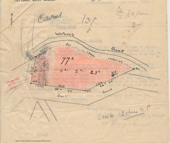 Eltham District Historical Society Inc
Booklet - Folder, Raynes Dickson Kiddle & Briggs Solicitors et al, Clintons Road, Christmas Hills, 1934-1938
Correspondence over a four year period (probably an incomplete file) on the behalf of Henry Cairns of Moonee Ponds and property owner at Christmas Hills / Watsons Creek including copy of a survey of his land title in relation to complaint regarding the Shire of Eltham encroaching on his land to make a road and subsequent purchase of land. The road provided acccess to the property of Mr W. Clinton of Heidelberg and other properties at Christmas Hills. Note by H.G. indicates that the property discussed in file is Clintons Road (not stated in file), possibly named after 1938. In December 1937 Eltham Shire Council agreed to purchase a block of land at the intersection of the Christmas Hills -- Smiths Gully roads from Mr Cairns to provide an outlet for the road which ran through the Cairns property. In March 1928 Mr Clinton had previously offered to contribute a sum of money towards the cost of purchasing the Cairns block to permit the road to go into his property was intending to transfer the property to himself. A Councilor was reported as being astounded in The Advertiser, 11 March 1938, as the land was needed for a road. Cr Baird: "The road was only to help his sports" Mr W. E. Clinton (Bill) was one of the founders of the Rob Roy Hill climb which took place at his property at Christmas Hills. He owned a garage in Heidleberg (See: https://cv.vic.gov.au/stories/sporting-life/speed-style-spirit-the-rob-roy-hillclimb/the-rob-roy-hillclimb/)16 pieces of paperraynes dickson kiddle & briggs solicitors, henry cairns, shire of eltham, roadworks, christmas hills, watsons creek, w. e. clinton, clintons road, rob roy climb -
 Melbourne Legacy
Document - Eulogy, James George Gillespie MBE, Hon. FIS Aus, FRICS, 1987
A copy of two addresses made at the funeral service for Legatee James George Gillespie, a long serving Legatee. The funeral was held on 25th May 1987 at St Stephen's Church, Caulfield. The addresses were by Rev. Vere Heazlewood (Parish Minister) and Wing-Commander Ron Austin. The article is very similar to the VALE notice published in the Bulletin and includes a snapshot of his life and career as a surveyor and long history of service in many fields. He was a member of the RMIT Council, and on the board of the Royal Women's Hospital - both of whom named building after him. He served on the Hospitals and Charities Commission, and the Nurses Memorial Centre and Greenvale Geriatric Centre. Plus many more. He enlisted in the AIF 18 months after his older brother had been killed on the first day of the landing at Gallipoli. He was in the 46th Battery, 12th Artillery Brigade as a gunner. He served in France and Belgium and was in Paris on the day the Armistice was signed. In World War 2 he was called up and was appointed Assistant-Director of Survey, with a rank of Lieut-Colonel. Jim Gillespie joined Legacy in June 1928, being nominated by Frank Doolan and seconded by Harold Peters. He filled many posts, including vice-president in 1937 and President in 1938 The article was part of an folder about of past presidents that served on the LCC in preparation for the photo board that was produced. The folder included biographical details and obituaries, eulogies and death notices of some Legatees. The items have been catalogued separately.A record of the life and service of Legatee Jim Gillespie. The information was published in the Bulletin and collected to record the lives of prominent legatees in a folder.Photocopy x 5 pages of the addresses made at the funeral of Legatee James Gillespie.eulogy, past presidents, jim-gillespie -
Glen Eira Historical Society
Document - SWIMMING POOLS
This file contains eight items pertaining to Caulfield’s swimming pools: 1/Report entitled ‘Future Options in the Provision of Public Swimming Facilities in the City of Caulfield’, dated March, 1983, prepared by Caulfield Planning Department of approx. 50 pages. 2/Photocopy of an article from ‘Port Phillip/Caulfield Leader’, dated 11/02/2002, concerning the cost of pool maintenance. 3/Public consultation paper entitled ‘Pools Past, Present and Future’, dated 07/03/2006, prepared by Glen Eira City Council, of 24 pages. 4/Article dated 08/03/2006 from ‘The Age’ concerning Glen Eira Residents’ fight to save swimming pools in Glen Eira. 5/Two page printed leaflet entitled ‘Save Our Pools’ dated 18/03/2006 produced by the northern memorial action group. 6/Three page printed survey sheet entitled ‘The East Bentleigh Swim Centre; an assessment of community needs’ undated, with accompanying return envelope. 7/Front page article from the ‘Glen Eira Caulfield Leader’ dated 04/04/2006 entitled ‘Save Our Pools’. 8/An article from ‘Port Phillip/Caulfield Leader’ dated 04/04/2006, concerning a former Glen Eira Council employee’s information about the Council’s pools report and a ‘letter to the editor’ by Sue Litchfield of Elsternwick containing her view of Glen Eira’s pool requirements.city of caulfield, caulfield, glen eira, caulfield planning department, palmer david, caulfield memorial pool, erlich noel, newton andrew, bentleigh east swim centre, city of glen eira, glen eira town hall, carnegie library, carnegie, shepparson avenue, mckinnon secondary college, east boundary road, koornang road, east bentleigh, feldman david, northern memorial pool, centre road, bentleigh, hudson rob, magee jim, antoine marc, swimming pools, olympic pools, public baths, baths, memorials, local government, northern memorial action group, community groups -
 Glen Eira Historical Society
Article - Caulfield Park
This file has thirteen items. 1/Typed note date and author unknown, titled development in Caulfield Park, describing the statuses commissioned for the park in 1975. 2/Photocopies undated of photographs of two of the statues. 3/Article dated 19/03/1980 in the Southern Cross newspaper about Caulfield Councils frisbee and golf day at the park. 4/Invitation for Mr. and Mrs. Campbell to attend tree planting ceremony at Caulfield Park on 23/10/1988 to commemorate Raoul Wallenberg. 5/Black and white photograph, undated, photographer unknown, of lake and fountain at Caulfield Park. 6/Three colour photographs dated June 1982 of Caulfield park. 7/Photocopy of photograph of War Memorial at Caulfield Park. 8/Leaflet advertising a parade and fair at the park on 25/05/1997. 9/Two black and white photographs, date and photographer unknown, of conservatory at the park after it burnt down, possibly in the 1920’s. 10/Friends of Caulfield Park newsletter dated July 2007 concerning the council’s plans for the park. 11/Article dated 19/10/2011 from Melbourne Weekly Bayside about the conservatory and its future, includes photograph. 12/Article dated 07/05/2013 in the Glen Eira Leader concerning the council’s plans for the conservatory. Includes dot points that original glasshouse (ex-Ripponlea) destroyed by fire in 1977 and replaced by existing hothouse. 13/Article dated 23/07/2013 from Glen Eira/Port Phillip Leader about public society survey concerning the conservatory’s future.caulfield park, north caulfield, balaclava road, caulfield city council, cannizzo phillip, statues, sculpture, hawthorn road, meserow hale, campbell jack, campbell mrs., braun emil, huppert michelle, wallenberg raoul, fountains, parks and reserves, monuments and memorials, parades and processions, festivals and celebrations, greenhouses, conservatories, catherine street, st aloysius school hall, friends of the caulfield park., caulfield park pavillion, pavilions, sportsgrounds, playing fields, playgrounds, glen eira council, wilde david, pilling neil, lipschutz michael, rippon lea mansion, magee jim, lobo oscar, sounness thomas -
 Forests Commission Retired Personnel Association (FCRPA)
Beechworth FCV District office sign
This sign proudly hung outside the Forests Commission Victoria (FCV) Beechworth office which is now site of the Forestry Heritage Museum. The granite building in the Beechworth's historic precinct was once the Gold Warden's Office and is one of the town's original buildings. The FCV was the main government authority responsible for management and protection of State forests in Victoria between 1918 and 1983. The Commission was responsible for ″forest policy, prevention and suppression of bushfires, issuing leases and licences, planting and thinning of forests, the development of plantations, reforestation, nurseries, forestry education, the development of commercial timber harvesting and marketing of produce, building and maintaining forest roads, provision of recreation facilities, protection of water, soils and wildlife, forest research and making recommendations on the acquisition or alienation of land for forest purposes″. The Forests Commission had a long and proud history of innovation and of managing Victoria's State forests but in September 1983 lost its discrete identity when it was merged into the newly formed Victorian Department of Conservation, Forests and Lands (CFL) along with the Crown Lands and Survey Department, National Park Service, Soil Conservation Authority and Fisheries and Wildlife Service. After the amalgamation the management of State forests and the forestry profession continued but the tempo of change accelerated, with many more departmental restructures occurring over the subsequent four decades. Responsibilities are currently split between the Department of Energy, Environment and Climate Action (DEECA), Forests Fire Management Victoria (FFMV), Parks Victoria, Melbourne Water, Alpine Resorts Commission, the State Government-owned commercial entity VicForests and the privately owned Hancock Victorian Plantations (HVP).Large office sign. Hand painted in traditional FCV mission brown and gold colour scheme.