Showing 159 items matching "cartography, maps"
-
 Wodonga & District Historical Society Inc
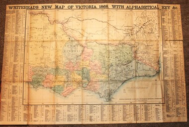
Map - Whiteheads New Map of Victoria, E. Whitehead & Co., engravers & lithographers, 1868
... Victoria Cartography...Rare maps...This is a very early map of Victoria showing Belvoir (Wodonga) Victoria Cartography Rare maps Victoria Whiteheads maps A detailed early map of Victoria with counties clearly marked and shaded and a detailed index. ...Edward Whitehead was a printer and publisher active in Melbourne during the latter half of the 19th century. Whitehead founded his printing business at 67 Collins Street East in 1864 and, though not focused on maps, began publishing his own series of maps of Victoria in 1867. He focussed on producing highly detailed folding maps of Victoria which included a very detailed index of place names. His series of maps of Victoria became one of the most successful and most profitable series of regional maps of Australia ever produced.This is a very early map of Victoria showing Belvoir (Wodonga)A detailed early map of Victoria with counties clearly marked and shaded and a detailed index. It also shows roads, post office towns, railways, telegraphs, gold mining areas and notes on topography. Relief shown by hachures and spot heights. Includes a list of towns with distances from Melbourne on 3 sides of map. It is produced on paper mounted on linen.victoria cartography, rare maps victoria, whiteheads maps -
 Bendigo Military Museum
Equipment - Architectural Railway Curves, JGS "Greenfield"
... Curves such as this set were used extensively by members of the Royal Australian Survey Corps when Cartography (map making) was produced by analog methods (hand drawn). ...Curves such as this set were used extensively by members of the Royal Australian Survey Corps when Cartography (map making) was produced by analog methods (hand drawn). ...A set of Architectural Railway Curves contains a multitude of different plastic curves to assist as a draughting aid in drawing long smooth curved linear features such as highways and railway lines. Curves such as this set were used extensively by members of the Royal Australian Survey Corps when Cartography (map making) was produced by analog methods (hand drawn). They fell into disuse in the mid 1970s once digital Cartography methods were introduced. .1 A set of Plastic Architectural Railway Curves. .2 A vanished wooden box that contains the set of Architectural Railway Curves. .3 A table of the sizes of each curve in the set.JGS "Greenfield", A quality Productroyal australian survey corps, rasvy, fortuna, army survey regiment, army svy regt -
 Department of Energy, Environment and Climate Action
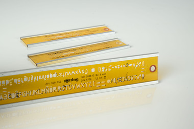
Rotring Lettering guides
... Different lettering guides were used depending on the scale of maps Cartographic guidance was provided by the FCV’s 1947 publication - “Handbook of Conventional Signs and Symbols for Use in Forest Mapping...Department of Energy, Environment and Climate Action 71-79 Kyle Road Altona North Different lettering guides were used depending on the scale of maps Cartographic guidance was provided by the FCV’s 1947 publication - “Handbook of Conventional Signs and Symbols for Use in Forest Mapping Forests Commission Victoria (FCV) mapping Surveying Rotring Scale and lettering sizes 5mm Plastic lettering guides for use with ink Rotring pens Rotring Lettering guides ...Different lettering guides were used depending on the scale of maps Cartographic guidance was provided by the FCV’s 1947 publication - “Handbook of Conventional Signs and Symbols for Use in Forest MappingPlastic lettering guides for use with ink Rotring pensRotring Scale and lettering sizes 5mmforests commission victoria (fcv), mapping, surveying -
 Bendigo Military Museum
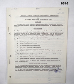
Administrative record - Royal Australian Survey Corps - A simple silk screen equipment for limited map reproduction by LTCOL HM Hall (RASvy) 1967, LtCol HM Hall (RASvy), 6 Feb 1967
... This paper deals with the employment of Hand operated Mobile Screen Printing Equipment and its associated cartographic techniques for limited map reproduction and overprinting under field conditions. ...Bendigo Military Museum 37 - 39 Pall Mall Bendigo goldfields This paper deals with the employment of Hand operated Mobile Screen Printing Equipment and its associated cartographic techniques for limited map reproduction and overprinting under field conditions. ...This paper deals with the employment of Hand operated Mobile Screen Printing Equipment and its associated cartographic techniques for limited map reproduction and overprinting under field conditions. Written by LtCol HM Hall (RASvy)8 x A4 page document containing typed text, photos and map extractroyal australian survey corps, rasvy, fortuna, army survey regiment, army svy regt, asr, school of military survey, sms -
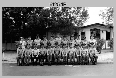 Bendigo Military Museum
Photograph - Army Survey Regiment’s Officers, Warrant Officers and Sergeants and Squadrons, at Fortuna, Bendigo, 1982
... A component of the Army Svy Regt’s cartographic map production was carried out by the Detachment, a sub-unit located at Bonegilla next to the School of Military Survey. ...A component of the Army Svy Regt’s cartographic map production was carried out by the Detachment, a sub-unit located at Bonegilla next to the School of Military Survey. ...This is a set of six staff photographs of the Army Survey Regiment’s Officers, Warrant Officers and Sergeants, and each of its four Squadrons at Fortuna, Bendigo in December 1982. Note - Air Survey Squadron’s photo was probably taken in July 1982 as they appear in winter dress. Air Survey Squadron was responsible for aerotriangulation, photogrammetric feature extraction and the AUTOMAP 1 system. Typical tasks were flight planning the acquisition of aerial photography, pugging, mensuration and block adjustments, photogrammetric extraction of topographic features from aerial photography, digital feature editing, map compilation, operating the scanner/plotter, operating the AUTOMAP 1 system and computer programming by civilians. Cartographic Squadron was responsible for the production of the following military products: Joint Operation Graphics, small-scale RAAF Air Charts, large-scale topographic line maps and orthophotomaps. Cartographic technician tasks were scribing, compiling, retouching, masking, type setting, type stickup, terrain embossing, correcting and proving quality control. Headquarters Squadron was responsible for the planning and coordination of map production and contracts. It also performed administrative and support functions such as personnel administration, pay, finance, transportation, records, map Library, kitchens, messes and facility maintenance. It was staffed by Army personnel from RASvy, RACT, AACC, RAAOC and RAEME corps. Other supporting staff at this time included the RAAF Liaison Officer, RAN Liaison Officer and several civilians employed in administration, the Q-Store and grounds maintenance. A component of the Army Svy Regt’s cartographic map production was carried out by the Detachment, a sub-unit located at Bonegilla next to the School of Military Survey. Lithographic Squadron was responsible for the reproduction of map materials and printing of military map products. The main tasks undertaken by photographic technicians were photographic enlargements, reductions and duplication of map reproduction material and processing of aerial photography. Printing technician tasks included platemaking, offset printing, map stock despatching and proofing.This is a set of six staff photographs of the Army Survey Regiment’s Officers, Warrant Officers and Sergeants, and its four Squadrons, at Fortuna, Bendigo, 1982. The black and white photographs were printed on photographic paper and are part of the Army Survey Regiment’s Collection. The photograph was scanned at 300 dpi. No personnel are identified. No personnel are identified. .1P – Annotated on front “OFFICERS MESS DEC ’82” .2P – Annotated on back “SGTS MESS DEC ’82” .4P– Annotated on front “CARTO SQN DEC ’82” .5P– Annotated on front “HQ SQN DEC ’82”royal australian survey corps, rasvy, army survey regiment, army svy regt, fortuna, asr, air survey, carto, litho -
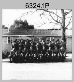 Bendigo Military Museum
Photograph - Detachment - Army Survey Regiment, Bonegilla, Victoria, c1973
... This is a set of six photographs of personnel from the Detachment - Army Survey Regiment taken in front of its main map production building at Bonegilla, Victoria in c1974. This cartographic map production sub-unit of the Army Survey Regiment operated in buildings owned by the School of Military Survey from 17th of June 1970 to the 30th of September 1985. ...This is a set of six photographs of personnel from the Detachment - Army Survey Regiment taken in front of its main map production building at Bonegilla, Victoria in c1974. This cartographic map production sub-unit of the Army Survey Regiment operated in buildings owned by the School of Military Survey from 17th of June 1970 to the 30th of September 1985. ...This is a set of six photographs of personnel from the Detachment - Army Survey Regiment taken in front of its main map production building at Bonegilla, Victoria in c1974. This cartographic map production sub-unit of the Army Survey Regiment operated in buildings owned by the School of Military Survey from 17th of June 1970 to the 30th of September 1985. A total of 800 topographic maps ranging in scale from 1:25,000 to 1: 250,000 scale were completed. A major focus of production in the 1970s was the cartographic completion of the Papua-New Guinea 1:100,000 map series and the Flexiflow quality control system was developed as a tool to coordinate production. The Flexiflow system comprised a series of job plans and charts linked to a task allocation to resource magnetic planning board. Using critical path analysis and task prioritisation, complex job planning was efficiently scheduled, and re-prioritisations readily made. Reproduction requirements were effectively coordinated by way of weekly courier to the Army Survey Regiment at Bendigo. Supervisors and technicians fully embraced the system as they could understand their role, others around them and the positive production achievements. WO1 Bill Boyd (who does not appear in this photograph) was the technical warrant officer for 11 years at the Detachment was awarded the OAM, the Order of Australia Medal for leading the development and the implementation of the Flexiflow system. By mid-1982, production of maps at these scales was undertaken digitally on Bendigo’s AUTOMAP 2 system and the Detachment reverted to production of small-scale large format RAAF aeronautical charts. Detachment personnel managed to produce 18 charts in the following two years, which was an impressive achievement for the staff, given major differences in format, specification and scales. Development of digital production of aeronautical charts in 1984-85 led to gradual reduction in production output and contracting out production was instigated to meet the shortfall and as a consequence the Detachment closed in September 1985. See pages 177 to 180 of Valerie Lovejoy’s book 'Mapmakers of Fortuna – A history of the Army Survey Regiment’ ISBN: 0-646-42120-4. for more information on the history of the Detachment at Bonegilla.This is a set of six photographs of the Detachment - Army Survey Regiment taken in front of the main map production building at Bonegilla, Victoria in c1974. The photographs were printed on photographic paper and are part of the Army Survey Regiment’s Collection. The photographic print and proofs were scanned at 600 dpi. .1) to .3) - Photo, black & white c1973. Back Row L to R: Peter Simpson, Chris Edwards, Ted Dudzinski, Terry Genge, Colin Harden, Rowan Gillies, Bob Rowley OAM, Steve Hansen, Stu Thaxter. Centre Row L to R: Kevin Boehm, Dennis McCarthy, Peter Cross, unidentified, Brian Ryan, unidentified, Ian Marner, unidentified, Phil Smalley. Front Row L to R: Geoff Haynes, Bruce Wetzig, Dave Thompson, unidentified, OC Bob Roche, Ike Lever, John McCulloch, Dick Barwald, unidentified. .4) - Photo, black & white c1973. Back Row L to R: Peter Simpson, Chris Edwards, unidentified (x2), Colin Harden, Rowan Gillies, Bob Rowley OAM, Steve Hansen, Stu Thaxter. Centre Row L to R: Kevin Boehm, Dennis McCarthy, Peter Cross, unidentified, Brian Ryan, unidentified, Ian Marner, Phil Smalley, unidentified, Dick Barwald. Front Row L to R: Geoff Haynes, Bruce Wetzig, Dave Thompson, unidentified, OC Bob Roche, Ike Lever, John McCulloch, unidentified (x2). .5) - Photo, black & white c1973. Back Row L to R: Geoff Haynes, unidentified, John McCulloch, Bruce Wetzig. Front Row L to R: Dave Thompson, Ike Lever, unidentified. .6) - Photo, black & white c1973. L to R: OC Bob Roche, unidentified.There are no personnel annotated.royal australian survey corps, rasvy, army survey regiment, detachment - army survey regiment, army svy regt, asr -
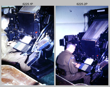 Bendigo Military Museum
Photograph - Cartographic Production – Army Survey Regiment, Fortuna, Bendigo, c1960 -1975
... This is a set of 10 photographs of Cartographic Squadron technicians undertaking map production tasks in at the Army Survey Regiment, Fortuna, Bendigo circa 1968 to 1975. ...This is a set of 10 photographs of cartographic Squadron technicians undertaking map production tasks at the Army Survey Regiment, Fortuna, Bendigo, c1968 to c1975. ...map. Royal Australian Survey Corps RASvy Army Survey Regiment Army Svy Regt Fortuna ASR carto .1P to .10P There are no annotations stored with the 35mm slides. This is a set of 10 photographs of cartographic ...This is a set of 10 photographs of Cartographic Squadron technicians undertaking map production tasks in at the Army Survey Regiment, Fortuna, Bendigo circa 1968 to 1975. Production was undertaken on the top floor of Fortuna Villa. The Fotosetter type setting machine shown in photos .1P and .2P. replaced the letterpress method of type production in 1956. CPL Arty Lane specialised in the operation of the Fotosetter type setting machine for many years. For more information on the Fotosetter, see page 71 of Valerie Lovejoy’s book 'Mapmakers of Fortuna – A history of the Army Survey Regiment’ ISBN: 0-646-42120-4. The computer based Editwriter Model 7500 typesetting system shown in photos .3P and .4P. was introduced in 1975 as a replacement to the aging Fotosetter. It was operated by a specialised technician, who generated a large variety of map type styles and sizes quickly and reliably, as well as text panels. Output on Copy proof adhesive backed stripping type film replaced messy wax and spray adhesives in 1978. The Editwriter capability supported all RASvy units and its contractor type setting requirements. The Aristo Co-ordinatorgraph shown in photos .5P to .7P was introduced in 1962. It was a large heavy steel framed light table with a scribing head that moved in a XY direction using a vernier calibrated measuring scale to 0.001 of an inch. Whilst hand operated it was much quicker and accurate than manual grid and graticule calculation, plotting and scribing. The history of co-ordinatorgraphs is covered in more detail with additional historic photographs, in pages 50 to 51 and page 88 of Valerie Lovejoy’s book 'Mapmakers of Fortuna – A history of the Army Survey Regiment’ ISBN: 0-646-42120-4. The scribing process as shown in photos .8P to .9P was the cartographic process of drafting features such as drainage, relief, vegetation, roads and culture on specially coated map reproduction material. The cartographic technician scribed out the map feature such as a contour to a specified line width on the map sheet, using a tool affixed with a sapphire tipped cutter. The quality control edit (Proving) stage of map production shown in photo .10P was the first opportunity to independently and systematically inspect a proof of the map.This is a set of 10 photographs of cartographic Squadron technicians undertaking map production tasks at the Army Survey Regiment, Fortuna, Bendigo, c1968 to c1975. The photographs were on 35mm colour slides and scanned at 96 dpi. They are part of the Army Survey Regiment’s Collection. .1) to .2) - Photo, colour, c1968, Fotosetter type setting machine, CPL Arty Lane. .3) to .4) - Photo, colour, c1975, Typesetting machine, ‘Editwriter’ Model 7500. .5) - Photo, colour, c1960s, PTE Desi Asaris and CPL Kalen Sargent operating Aristo Co-ordinatorgraph equipment. .6) - Photo, colour, c1970s, L to R: CPL Desi Asaris, CPL John Bennett, operating Aristo Co-ordinatorgraph equipment. .7) - Photo, colour, c1970s, L to R: CPL John Bennett, CPL Desi Asaris operating Aristo Co-ordinatorgraph equipment. .8) - Photo, colour, c1970s, L to R: CPL Desi Asaris scribing drainage, CPL John Bennett. .9) - Photo, colour, c1970s, CPL Desi Asaris scribing drainage. .10) - Photo, colour, c1970s, L to R: CPL Desi Asaris, CPL John Bennett and their supervisor WO2 Roger Rix inspecting features on an aeronautical chart proof. .1P to .10P There are no annotations stored with the 35mm slides.royal australian survey corps, rasvy, army survey regiment, army svy regt, fortuna, asr, carto -
 Bendigo Military Museum
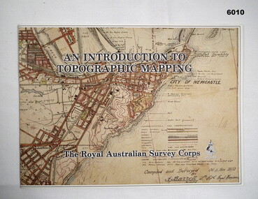
Pamphlet - An Introduction to Topographic Mapping, C 1991
... The pamphlet comprehensively detailed the eight steps of topographic map production: Establish Survey Control, Aerial Photography, Aerotriangulation, Stereoplotting, Field Verification, Cartography, Printing and Storage/Map Distribution. ...The pamphlet comprehensively detailed the eight steps of topographic map production: Establish Survey Control, Aerial Photography, Aerotriangulation, Stereoplotting, Field Verification, Cartography, Printing and Storage/Map Distribution. ...This pamphlet was published by the Army Survey Regiment as an overview of the Royal Australian Survey Corps (RASvy), its role and unit structure circa 1991, prior to RASvy’s disbandment in 1996. The pamphlet comprehensively detailed the eight steps of topographic map production: Establish Survey Control, Aerial Photography, Aerotriangulation, Stereoplotting, Field Verification, Cartography, Printing and Storage/Map Distribution. Leading technologies used by RA Svy in 1991 included GPS control surveys, 5 colour printing on the Speedmaster offset press and bulk map packaging using the Map Handling Station (with guillotine). Digital map production was operating on the AUTOMAP 2 system, before the “Newheart” system upgrade two years later. Printed on the pamphlet cover was a portion of the plane tabled “four inches to a mile” map of Newcastle. This was compiled and surveyed in 1910 by LCPL A. Barrett, a member of the RAE Detachment, as part of the first major topographic mapping effort of Australia.This is a Royal Australian Survey Corp pamphlet with a historical map printed in colour on cardboard on both sides of the cover. There are 16 pages printed in colour on gloss paper, with photos, diagrams and descriptions. The pamphlet is bounded by two staples on its spine. Each of the 17 images were scanned at 300 dpi in JPEG (.jpg) format and stored on the attached 16 Gb USB memory stick. The images have been converted into MPEG-4 (.mp4) video format, 4Mb in size and runs for 2:16 minutes and is also stored on the memory stick.royal australian survey corps, rasvy, fortuna, army survey regiment, army svy regt, asr -
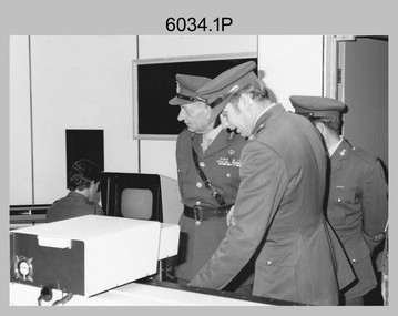 Bendigo Military Museum
Photograph - Visit by the Chief of the General Staff to the Army Survey Regiment, Fortuna, Bendigo, 1979
... L to R: CPL Dennis Learmonth, acting OC CAPT Bob Roche, CAPT Eddy Schulze, LTGEN General Sir Donald Dunstan AC, KBE CB; SSGT John ‘JB’ Barrie discuss cartographic map compilation procedures .9) - Photo, black and white, 1979. ...L to R: CPL Dennis Learmonth, acting OC CAPT Bob Roche, CAPT Eddy Schulze, LTGEN General Sir Donald Dunstan AC, KBE CB; SSGT John ‘JB’ Barrie discuss cartographic map compilation procedures .9) - Photo, black and white, 1979. ...This is a set of 14 photographs of a visit to the Army Survey Regiment, Fortuna, Bendigo on the 5th of June 1979 by the Chief of the General Staff (CGS) Lieutenant General Sir Donald Dunstan AC, KBE, CB. He was accompanied by his wife. They were escorted through the production areas of the Army Survey Regiment by the CO LTCOL Bob Skitch. Lieutenant General Sir Donald Dunstan AC, KBE, CB was an esteemed Australian Army officer, who was CGS from 1977 to 1982. Upon retirement from the Army in 1982, he was appointed to the position of Governor of South Australia from 1982 to 1991. LTCOL Bob Skitch was the CO of the Army Svy Rgt from 1976 to 1980. Also featuring in these photos is MAJ Peter Eddy, who was the OC of Air Survey Squadron. He was later promoted to LTCOL and was CO of the Army Svy Rgt from 1981 to 1982. See item 6035.9P for photos of the CGS’s presentation of the Defence Force Service Medal to four recipients.This is a set of 14 photographs of a visit by the Chief of the General Staff to the Army Survey Regiment Fortuna, Bendigo on the 5th of June 1979. The photographs were printed on photographic paper and are part of the Army Survey Regiment’s Collection. They were scanned at 300 dpi. .1) - Photo, black and white, 1979. Tour of Air Survey Squadron. L to R: unidentified, LTGEN General Sir Donald Dunstan AC, KBE, CB; OC MAJ Peter Eddy, unidentified. .2) - Photo, black and white, 1979. Tour of Air Survey Squadron. LTGEN General Sir Donald Dunstan AC, KBE, CB; views 3D stereoscopic aerial photography on a Zeiss (Jena) Stecometer. OC MAJ Peter Eddy is on his right. .3) - Photo, black and white, 1979. Tour of Air Survey Squadron. L to R: unidentified, CO LTCOL Bob Skitch, OC MAJ Peter Eddy, LTGEN General Sir Donald Dunstan AC, KBE CB viewing an aerial photograph. WO1 Brian Mead and others are operating a Wild PUG4 point transfer device. .4) - Photo, black and white, 1979. Enlargement of photo .3). Tour of Air Survey Squadron. L to R: unidentified, CO LTCOL Bob Skitch, OC MAJ Peter Eddy, LTGEN General Sir Donald Dunstan AC, KBE CB viewing an aerial photograph. .5) - Photo, black and white, 1979. Tour of Air Survey Squadron. LTGEN General Sir Donald Dunstan AC, KBE, CB; and unidentified technician view 3D stereoscopic aerial photography on a Wild B8 stereo plotter. .6) - Photo, black and white, 1979. Tour of Air Survey Squadron. L to R: OC MAJ Peter Eddy LTGEN General Sir Donald Dunstan AC, KBE CB; CO LTCOL Bob Skitch, view the output of a verification plot on an AUTOMAP 1 Gerber 1442 drum plotter. .7) - Photo, black and white, 1979. Tour of Air Survey Squadron. L to R: CO LTCOL Bob Skitch, unidentified aide de camp officer, LTGEN General Sir Donald Dunstan AC, KBE CB; OC MAJ Peter Eddy discuss aero triangulation planning documents. CAPT Don Maskew in background. .8) - Photo, black and white, 1979. Tour of Cartographic Squadron. L to R: CPL Dennis Learmonth, acting OC CAPT Bob Roche, CAPT Eddy Schulze, LTGEN General Sir Donald Dunstan AC, KBE CB; SSGT John ‘JB’ Barrie discuss cartographic map compilation procedures .9) - Photo, black and white, 1979. Tour of Cartographic Squadron. L to R: Tech WO WO1 Roger Rix, acting OC CAPT Bob Roche, CAPT Eddy Schulze, unidentified visitor, Mrs Dunstan with examples of map products. .10) - Photo, black and white, 1979. Tour of Cartographic Squadron. L to R: CPL Terry Danger, CO LTCOL Bob Skitch, LTGEN General Sir Donald Dunstan AC, KBE CB; discuss terrain embossing (hill shading) procedures. .11) - Photo, black and white, 1979. Tour of Cartographic Squadron. L to R: CO LTCOL Bob Skitch, LTGEN General Sir Donald Dunstan AC, KBE CB; acting OC CAPT Bob Roche, SSGT Dick Manley, CAPT Don Maskew and CAPT Steve Cooper in background. SPR Cheryl Lofthouse is retouching blemishes on a map separation film negative. .12) - Photo, black and white, 1979. Tour of Lithographic Squadron. L to R: CAPT Stan Vote, unidentified aide de camp officer, CO LTCOL Bob Skitch, LTGEN General Sir Donald Dunstan AC, KBE CB; MAJ Sam Schwartz EXCH-US, LT John Harrison discuss bulk map printing processes with an Ultra-MAN-III Printing Press. .13) - Photo, black and white, 1979. Officers Mess L to R: LTGEN General Sir Donald Dunstan AC, KBE CB; with CO LTCOL Bob Skitch. .14) - Photo, black and white, 1979. Officers Mess L to R: MAJ Peter Eddy, LTGEN General Sir Donald Dunstan AC, KBE CB..1P to .14P – no annotationsroyal australian survey corps, rasvy, army survey regiment, army svy regt, fortuna, asr -
 Bendigo Military Museum
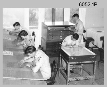
photograph - Cartographic Squadron Production – Army Survey Regiment, Fortuna, c1980
... Scribing was the cartographic process of drafting features such as drainage, relief, vegetation, roads and culture on specially coated map reproduction material. ...This is a set of 12 photographs of Cartographic Squadron performing four map production tasks at the Army Survey Regiment, Fortuna, Bendigo c1980. ...Scribing was the cartographic process of drafting features such as drainage, relief, vegetation, roads and culture on specially coated map reproduction material. ...This collection of 12 photos was most likely taken in 1980. The photos were most likely taken in Cartographic Squadron’s Ante Room, the Attic and small offices on the top floor of Fortuna Villa. The computer based Editwriter typesetting system was introduced in 1975 as a replacement to the aging Fotosetter machine. It was operated by a specialised technician, who generated a large variety of map type styles and sizes quickly and reliably, as well as text panels. CPL Richards performed this task for several years and in photo .1P and .2P is reading off a type order next to the computer monitor. Output on Copy proof adhesive backed stripping type film replaced messy wax and spray adhesives in 1978. The Editwriter capability supported all RASvy units and contractor type setting requirements. Scribing was the cartographic process of drafting features such as drainage, relief, vegetation, roads and culture on specially coated map reproduction material. The cartographic technician scribed out the map feature such as a contour to a specified line width on the map sheet, using a tool affixed with a sapphire tipped cutter. The quality control edit (Proving) stage of map production was the first opportunity to inspect a proof of the map independently and systematically. Proving tasks were carried out by technicians conversant of the map product specification and task requirement, however, was not involved in its production. Corrections were identified, marked up and sent to back to the correcting section or contractors. Terrain Embossing was a manual map production technique to produce hill shading on medium to small scale graphics and air charts. SPR John Martin is seen in photos .8P to.10P using a fine embossing metal stylus to push down on the drainage impression on a thin malleable opaque plastic material (AK Poligraphy). Ridge lines were then pushed down using the contour impression as a guide, on the opposing side of the AK Poligraphy to create a 3D plastic model terrain effect. The map impression was sprayed with white paint and photographed to create a contone tone hill shade. SPR Gina (Coore) Neilson is seen in photo .11P washing a contone positive of a land mass in a solution. The contone components were registered to the map sheet, as shown in photo .12P and masked using an air brush and a halftone negative was then created. The terrain embossing method of producing hill shading was more efficient to produce than previous specialised artistic methods such pencil/eraser and air brush. Furthermore, a more consistent enhancement of terrain on charts was achieved between technicians.This is a set of 12 photographs of Cartographic Squadron performing four map production tasks at the Army Survey Regiment, Fortuna, Bendigo c1980. The first ten photographs were on 35mm negative film and were scanned at 96 dpi. Photos .11P and .12P were on photographic paper and scanned at 300 dpi. They are part of the Army Survey Regiment’s Collection. .1) - Photo, black & white, c1980, Editwriter typesetter, CPL Paul Richards. .2) - Photo, black & white, c1980, Editwriter typesetter, CPL Paul Richards. .3) - Photo, black & white, c1980, Scribing contours on a RAAF Chart, SPR Megan (McBurney) Reynolds. .4) - Photo, black & white, c1980, Scribing contours on a RAAF Chart, SPR Megan (McBurney) Reynolds. .5) - Photo, black & white, c1980, Scribing contours on a RAAF Chart, SPR Rod Skidmore. .6) - Photo, black & white, c1980, Scribing contours on a RAAF Chart, SPR Rod Skidmore. .7) - Photo, black & white, c1980, Formal quality control edit (Proving), CPL Ian Belmont. .8) - Photo, black & white, c1980, Hill Shade Terrain Embossing, SPR John Martin. .9) - Photo, black & white, c1980, Hill Shade Terrain Embossing, SPR John Martin. .10) - Photo, black & white, c1980, Hill Shade Terrain Embossing, SPR John Martin. .11) - Photo, black & white, c1980, Hill Shade Terrain Embossing, SPR Gina (Coore) Neilson. .12) - Photo, black & white, c1980, Hill Shade Terrain Embossing, unidentified..1P to .10P No personnel are identified. .11P and .12P annotated ‘Terrain Embossing’royal australian survey corps, rasvy, army survey regiment, army svy regt, fortuna, asr, carto -
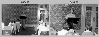 Bendigo Military Museum
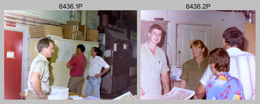
Photograph - Army Survey Regiment Open Day - Briefings and Tours, Fortuna, Bendigo, 1990
... Refer to items 6435.35P and 6436.18P for more photos of the Open Day taken in the Map Production areas of Air Survey and Cartographic Squadron, and production areas of Lithographic Squadron. ...Refer to items 6435.35P and 6436.18P for more photos of the Open Day taken in the Map Production areas of Air Survey and Cartographic Squadron, and production areas of Lithographic Squadron. ...These 27 photographs were taken at an Army Survey Regiment Open Day at Fortuna Villa, Bendigo on the 24th of February 1990. This occasion was one of several events held to commemorate the 75th anniversary of the formation of the Royal Australian Survey Corps. Although historical tours of Fortuna occurred on a regular basis, this was the first technical open day since 1972. The Royal Australian Survey Corps recognised that an Open Day was the best way for the local community in Bendigo to gain an insight into the unit’s important role as Defence’s map production agency, its technical equipment, and its economic importance to Bendigo. It also gave them an opportunity to tour through historic Fortuna Villa. This occasion is covered in more detail in page 143 of Valerie Lovejoy’s book 'Mapmakers of Fortuna – A history of the Army Survey Regiment’ ISBN: 0-646-42120-4. Refer to items 6435.35P and 6436.18P for more photos of the Open Day taken in the Map Production areas of Air Survey and Cartographic Squadron, and production areas of Lithographic Squadron. Photo prints of some of these photos were scanned and catalogued in items 6247.30P and 6291.6P.These 27 photographs were taken at an Army Survey Regiment Open Day held at Fortuna, Bendigo on the 24th of February 1990. The 35mm colour and black & white negatives photographs were scanned at 96 dpi and are part of the Army Survey Regiment’s Collection. .1) & .2) - Photo, black & white, 1990. Ballroom - Visitor briefings by CO LTCOL Rene van den Tol. .3) - Photo, colour, 1990. Ballroom - Visitor briefings by MAJ Ray Redman. .4) - Photo, colour, 1990. Ballroom - Visitor briefings by unidentified UK Exchange officer. .5) - Photo, black & white, 1990. Music Room - Visitor briefings by MAJ Bob Williams. .6) - Photo, black & white, 1990. Orderly Room - ADJT CAPT Peter Parkes. .7) - Photo, colour, 1990. Music Room - ADJT CAPT Peter Parkes with civilian visitors. .8) - Photo, colour, 1990. Music Room - Visitor briefings by CPL Le-Anne (Smallshaw) Shirley. .9) - Photo, colour, 1990. Entrance Foyer - Visitor briefings. .10) - Photo, colour, 1990. CO’s Office - Visitor briefings by CPL Raelene (Munting) Brodie. .11) - Photo, colour, 1990. Mr Pat Thwaites outlining utilisation of satellite imagery to civilian visitors. .12) - Photo, black & white, 1990. Mr Pat Thwaites outlining utilisation of satellite imagery to civilian visitors. .13) - Photo, colour, 1990. Staircase leading up to the top floor - Visitor briefings by CPL Ian Nelson. .14) - Photo, colour, 1990. Building 16 - Visitor briefings by RSM WO1 Neville Stone. .15) - Photo, colour, 1990. Civilian visitors enjoying views of the garden from Fortuna Villa’s rooftop. .16) - Photo, black & white, 1990. Visitor briefings at Fortuna’s rear steps. .17) - Photo, black & white, 1990. Outside Building 16 - Visitor briefings by WO1 Gary Warnest. .18) - Photo, colour, 1990. Outside Building 16 - Visitor briefings by WO2 Adrian ‘Charlie’ Creedy. .19) - Photo, colour, 1990. Outside Building 16 - L to R: SPR Sue (Foote) Bourne, LCPL Sandy Winn, WO2 Adrian ‘Charlie’ Creedy. .20) - Photo, colour, 1990. Outside Building 16 - SGT Greg Byers. .21) - Photo, colour, 1990. Visitors enjoying Devonshire Tea in the gardens next to the Tavern. .22) - Photo, colour, 1990. RSM WO1 Neville Stone and family enjoying Devonshire Tea in the gardens next to the Tavern. .23) - Photo, colour, 1990. Visitors relaxing in the garden next to Fortuna’s lake. .24) - Photo, black & white, 1990. CPL Trevor Poll and others serve up BBQ lunch next to the tennis courts. .25) to .27) - Photo, colour, 1990. Parking at a premium inside the Army Survey Regiment and Chum Street..1P to .27P – no annotationsroyal australian survey corps, rasvy, army survey regiment, army svy regt, fortuna, asr -
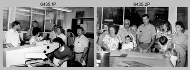 Bendigo Military Museum
Photograph - Army Survey Regiment Open Day - Map Production, Fortuna, Bendigo, 1990
... Cartography – L to R: SPR Jeanette (Lane) Dury-Lane, CPL Diane (Thomas) Soutar with civilian visitors. Army Survey Regiment Open Day - Map Production, Fortuna, Bendigo Photograph Army Survey Regiment Open Day - Map Production, Fortuna, Bendigo Army Survey Regiment ...These 35 photographs were taken at an Army Survey Regiment Open Day at Fortuna Villa, Bendigo on the 24th of February 1990. This occasion was one of several events held to commemorate the 75th anniversary of the formation of the Royal Australian Survey Corps. Although historical tours of Fortuna occurred on a regular basis, this was the first technical open day since 1972. The Royal Australian Survey Corps recognised that an Open Day was the best way for the local community in Bendigo to gain an insight into the unit’s important role as Defence’s map production agency, its technical equipment, and its economic importance to Bendigo. It also gave them an opportunity to tour through historic Fortuna Villa. This occasion is covered in more detail in page 143 of Valerie Lovejoy’s book 'Mapmakers of Fortuna – A history of the Army Survey Regiment’ ISBN: 0-646-42120-4. Refer to items 6434.27P and 6436.18P for more photos of the Open Day taken inside Fortuna, the garden areas and production areas of Lithographic Squadron. Photo prints of some of these photos were scanned and catalogued in items 6247.30P and 6291.6P.These 35 photographs were taken at an Army Survey Regiment Open Day held at Fortuna, Bendigo on the 24th of February 1990. The 35mm colour and black & white negatives photographs were scanned at 96 dpi and are part of the Army Survey Regiment’s Collection. .1) - Photo, black & white, 1990. CPL Neale ‘Tex’ Houston with visitors in Aerotriangulation Section. .2) - Photo, black & white, 1990. L to R: MAJ Peter Clark and WO2 Neil ‘Ned’ Kelly with visitors in Aerotriangulation Section. .3) - Photo, black & white, 1990. SGT Bruce Hammond with visitors in Aerotriangulation Section. .4) - Photo, colour, 1990. SGT Bruce Hammond with visitors in Aerotriangulation Section. .5) - Photo, colour, 1990. SGT Steve Gloster with visitors in Aerotriangulation Section. .6) - Photo, colour, 1990. L to R: CPL Noel Brinsmead and CPL Darren Wilkinson with visitors in Aerotriangulation Section. .7) - Photo, colour, 1990. L to R: CPL Noel Brinsmead with visitors in Aerotriangulation Section. .8) - Photo, colour, 1990. MAJ Peter Clark with visitors in Aerotriangulation Section. .9) - Photo, colour, 1990. CPL Mark Lander with visitors in Plotting Section. .10) - Photo, colour, 1990. SSGT Andy Boath with visitors in Plotting Section. .11) - Photo, colour, 1990. SPR Stuart Bowd with visitors in Plotting Section. .12) - Photo, colour, 1990. CAPT Roger Hancock with visitors in Plotting Section. .13) & .14) - Photo, colour, 1990. AUTOMAP 2 - CPL Peter Peterson with visitors. .15) - Photo, colour, 1990, AUTOMAP 2 - L to R: SSGT Graham Johnston, SPR Grant Davis with civilian visitors. .16) - Photo, colour, 1990, AUTOMAP 2 - L to R: CPL Steve McGuiness, SSGT Graham Johnston with civilian visitors. .17) - Photo, colour, 1990, AUTOMAP 2 - civilian visitors. .19) - Photo, colour, 1990, AUTOMAP 2 - L to R: unidentified, SPR Tony Jackson, CPL Mark Westbrook, SSGT Bob Bright, with civilian visitors. .20) - Photo, colour, 1990, AUTOMAP 2 - L to R: WO2 Adrian ‘Charlie’ Creedy, CPL Mark Westbrook, SPR Mick Duggan with civilian visitors. .21) - Photo, colour, 1990, AUTOMAP 2 - L to R: SPR Mick Duggan, CO LTCOM Rene van den Tol, SSGT Bob Bright, CPL Mark Westbrook with civilian visitors. .22) - Photo, colour, 1990, AUTOMAP 2 - L to R: SPR Damien Nolan, unidentified, SPR Peter Smyth with civilian visitors. .23) - Photo, black & white, 1990, AUTOMAP 2 - L to R: SPR Peter Smyth, CAPT Steve Hledik, SGT Martin Evans, MAJ Neil Taylor with civilian visitors. .24) - Photo, black & white, 1990, AUTOMAP 2 - L to R: SPR Mick Duggan, CPL Mark Westbrook with civilian visitors. .25) - Photo, black & white, 1990, AUTOMAP 2 – LCPL Sandy Winn with civilian visitor. .26) - Photo, black & white, 1990. Display of digital storage media. .27) & .28) - Photo, colour, 1990. Cartography - SPR Ian Baldwin with civilian visitors. .29) - Photo, black & white, 1990. Cartography - SPR Ian Baldwin with civilian visitors. .30) - Photo, black & white, 1990. Cartography - SGT Sherri (Dally) Burke with civilian visitors. .31) - Photo, colour, 1990. Cartography - L to R: SGT Sherri (Dally) Burke, SSGT Dennis Learmonth with civilian visitors. .32) - Photo, colour, 1990. Cartography – SGT Barry Hogan with civilian visitors. .33) & .34) - Photo, colour, 1990. Cartography – CPL Dan Cirsky with civilian visitors. .35) - Photo, colour, 1990. Cartography – L to R: SPR Jeanette (Lane) Dury-Lane, CPL Diane (Thomas) Soutar with civilian visitors..1P to .35P – no annotationsroyal australian survey corps, rasvy, army survey regiment, army svy regt, fortuna, asr, automap 2 -
 Bendigo Military Museum
Photograph - Army Survey Regiment Open Day – Lithographic Squadron, Fortuna, Bendigo, 1990
... Refer to items 6434.27P and 6435.35P for more photos of the Open Day taken inside Fortuna, the garden areas and Map Production areas of Air Survey and Cartographic Squadron. Photo prints of some of these photos were scanned and catalogued in items 6247.30P and 6291.6P....Refer to items 6434.27P and 6435.35P for more photos of the Open Day taken inside Fortuna, the garden areas and Map Production areas of Air Survey and Cartographic Squadron. Photo prints of some of these photos were scanned and catalogued in items 6247.30P and 6291.6P. ...These 18 photographs were taken at an Army Survey Regiment Open Day at Fortuna Villa, Bendigo on the 24th of February 1990. This occasion was one of several events held to commemorate the 75th anniversary of the formation of the Royal Australian Survey Corps. Although historical tours of Fortuna occurred on a regular basis, this was the first technical open day since 1972. The Royal Australian Survey Corps recognised that an Open Day was the best way for the local community in Bendigo to gain an insight into the unit’s important role as Defence’s map production agency, its technical equipment, and its economic importance to Bendigo. It also gave them an opportunity to tour through historic Fortuna Villa. This occasion is covered in more detail in page 143 of Valerie Lovejoy’s book 'Mapmakers of Fortuna – A history of the Army Survey Regiment’ ISBN: 0-646-42120-4. Refer to items 6434.27P and 6435.35P for more photos of the Open Day taken inside Fortuna, the garden areas and Map Production areas of Air Survey and Cartographic Squadron. Photo prints of some of these photos were scanned and catalogued in items 6247.30P and 6291.6P.These 18 photographs were taken at an Army Survey Regiment Open Day held at Fortuna, Bendigo on the 24th of February 1990. The 35mm colour and black & white negatives photographs were scanned at 96 dpi and are part of the Army Survey Regiment’s Collection. .1) - Photo, colour, 1990. Print Troop – WO2 Rob Bogumil with visitors. .2) - Photo, colour, 1990. Print Troop – L to R: SPR Ross Anza, LCPL Janet Murray with visitors. .3) - Photo, black & white, 1990. Print Troop – L to R: LCPL Janet Murray, MAJ Bob Coote, SPR Gary Lord with visitors. .4) - Photo, black & white, 1990. Photo Troop – L to R: WO2 Keith Fenton RE UK Exchange, SGT Steve Burke with visitors. .5) - Photo, colour, 1990. Photo Troop – SGT Steve Burke with visitors. .6) - Photo, colour, 1990. Photo Troop – L to R: unidentified, SGT Steve Burke with visitors. .7) - Photo, colour, 1990. Print Troop – L to R: CPL Peter Breukel, WO2 Keith Fenton RE. UK Exchange with visitors. .8) - Photo, black & white, 1990. Photo Troop - WO2 Keith Fenton RE. UK Exchange. .9) - Photo, black & white, 1990. Print Troop - civilian visitors. .10) - black & white, Print Troop, 1990. - L to R: civilian visitors, SSGT Ian Nichols, CPL John ‘Flash’ Anderson. .11) - Photo, black & white, 1990. Print Troop - L to R: SSGT Ian Nichols, CPL Dale Hudson, Planeta printing press, with civilian visitors. .12) - Photo, colour, 1990. Print Troop - L to R: SSGT Ian Nichols, CAPT Roger Hancock with civilian visitors. .13) - Photo, colour, 1990. Print Troop - LT Marty Lyons with civilian visitors. .14) - Photo, black & white, 1990. Print Troop - L to R: LT Marty Lyons, unidentified with civilian visitors. .15) - Photo, black & white, 1990. Orthophoto Mapping Section - L to R: SSGT Peter Imeson, SGT Bob Garritty with civilian visitors. .16) - Photo, colour, 1990. Optronics raster scanner - WO2 Adrian ‘Charlie’ Creedy with civilian visitors. .17) - Photo, colour 1990. Outside Photo Troop office - L to R: SSGT Rhys De Laine, WO2 Rob Bogumil. .18) - Photo, black & white, 1990. Photo Troop - civilian visitors..1P to .18P – no annotationsroyal australian survey corps, rasvy, army survey regiment, army svy regt, fortuna, asr, litho sqn -
 Bendigo Military Museum
Photograph - Lithographic Squadron with DCP Students, Army Survey Regiment, Fortuna Villa, Bendigo, 1985
... RA Svy also provided technical training to DCP students in map production skills such as, cartography and photogrammetry at the Army Survey Regiment and the School of Military Survey, Bonegilla. ...RA Svy also provided technical training to DCP students in map production skills such as, cartography and photogrammetry at the Army Survey Regiment and the School of Military Survey, Bonegilla. ...This is a set of six photographs of Lithographic Squadron personnel with Defence Cooperation Program (DCP) students at the Army Survey Regiment, Fortuna Villa, Bendigo Victoria, 1985. These informal and formal group photos were taken on the day of a CO’s Parade. Litho Squadron provided printing and photographic reproduction to the two DCP students. RA Svy also provided technical training to DCP students in map production skills such as, cartography and photogrammetry at the Army Survey Regiment and the School of Military Survey, Bonegilla. The Australian Defence Force over several years sponsored international students from counties such as Indonesia, Malaysia, Papua New Guinea, Philippines, Solomon Islands and Vanuatu. It is not known which South Pacific country these DCP students came from.This is a set of six photographs of Lithographic Squadron personnel with Defence Cooperation Program (DCP) students at the Army Survey Regiment, Fortuna Villa, Bendigo Victoria, 1985. The photographs are on 35mm negative film and were scanned at 96 dpi. They are part of the Army Survey Regiment’s Collection. .1) Photo, black & white, 1985. L to R: Warren ‘Waldo’ Shirley, Per Andersen, Trevor Osborne, Roy Hicks, Lance Strudwick, Steve Burke, Dale Hudson, Paul Baker, Ralph Chant, Peter Breukel, John ‘Flash’ Anderson, Chad Hardwick, Peter Imeson, DCP student John or Henry, unidentified, Greg Rowe, John South, unidentified, Mick ‘Buddha’ Ellis, John ‘Junior’ Whaling, Terry King, Daryl South, DCP student John or Henry, Bronwyn Jones, John Bateman, Kerron South, unidentified officer, Peter Dillon, Kim Reynolds, Rob Jones, unidentified, Jeff Lynch, Garry Hudson, Mark ‘Dogs’ Doherty, Jim Ash, Gavin Neilson, Jeff Willey, unidentified, Graham Johnston, Steve Egan, Peter Barrett, George Austen, Dave Miles. .2) - Photo, black & white, 1985. L to R: Warren ‘Waldo’ Shirley, Per Andersen, Trevor Osborne, Roy Hicks, Lance Strudwick, Steve Burke, Dale Hudson, Paul Baker, Ralph Chant, Peter Breukel, John ‘Flash’ Anderson, Chad Hardwick, Peter Imeson, DCP student John or Henry, unidentified, Greg Rowe, John South, unidentified, Mick ‘Buddha’ Ellis, John ‘Junior’ Whaling, Terry King, Daryl South, DCP student John or Henry, John Bateman, Kerron South, unidentified officer, Peter Dillon, Kim Reynolds, Rob Jones, unidentified, Jeff Lynch, Garry Hudson, Mark ‘Dogs’ Doherty, Jim Ash, Gavin Neilson, Jeff Willey, unidentified, Graham Johnston, Steve Egan, Peter Barrett, Dave Miles, George Austen. .3) - Photo, black & white, 1985. Photo Troop L to R: Steve Burke, Garry Hudson, Warren ‘Waldo’ Shirley, Ralph Chant, Gavin Neilson, DCP student John or Henry, Paul Baker, Trevor Osborne, Peter Imeson, Mick ‘Buddha’ Ellis, unidentified, John ‘Junior’ Whaling, DCP student John or Henry, Chad Hardwick, Terry King, Dave Miles, Graham Johnston, Kerron South, Bronwyn Jones, Rob Jones, unidentified. .4) - Photo, black & white, 1985. L to R: WO1 Jeff Lynch, DCP student John or Henry, CAPT John South, unidentified officer, DCP student John or Henry, WO2 Dave Miles. .5) & .6) - Photo, black & white, 1985. Print Troop L to R: Per Andersen, Daryl South, Lance Strudwick, Peter Dillon, DCP student John or Henry, Jeff Willey, John Bateman, Roy Hicks, Paul Davis, Dale Hudson, Kim Reynolds, Greg Rowe, Jim Ash, DCP student John or Henry, Mark ‘Dogs’ Doherty, Peter Breukel, Peter Barrett, unidentified, unidentified officer, Steve Egan, George Austen.No personnel are identified. Date and DCP students noted on film negative sleeve.royal australian survey corps, rasvy, army survey regiment, army svy regt, fortuna, asr, litho sqn, litho -
 Bendigo Military Museum
Poster - Map Production flow chart poster using Automap 2, Army Survey Regiment, Bendigo, 1982
... This poster designed to be folded into a brochure describes the second phase of the computer assisted cartographic system to be used by the Royal Australian Survey Corps in the establishment of a topographic data base, Future tactical applications and map products using the data base are displayed. ...Bendigo Military Museum 37 - 39 Pall Mall Bendigo goldfields This poster designed to be folded into a brochure describes the second phase of the computer assisted cartographic system to be used by the Royal Australian Survey Corps in the establishment of a topographic data base, Future tactical applications and map products using the data base are displayed. ...This poster designed to be folded into a brochure describes the second phase of the computer assisted cartographic system to be used by the Royal Australian Survey Corps in the establishment of a topographic data base, Future tactical applications and map products using the data base are displayed. A topographic map of Series R631 1:100,000 Helenvale, Queensland printed on the reverse side that was produced by the Automap system using information from the topographic data base. This is the fifth edition of the poster.A multi colour poster of map production using the Automap 2 system. Poster shows a schematic and pictorial flow chart diagram of the stages of the map production process using the Automap 2 system. The poster was intended to be folded into a small brochure. A 1:100,000 Army Survey Map Series R631, 7966 Helenvale, Queensland Edition 2 is printed on the reverse side of the poster. The map is an example of one of the initial maps produced on the Automap 2 System at the Army Survey Regiment, Bendigo.royal australian survey corps, rasvy, fortuna, army survey regiment, army svy regt, asr, automap 2 -
 Bendigo Military Museum
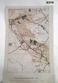
Map - Map Extract - Charterhouse of Mendip, John James Raisbeck, Unknown
... Cartographic Section until February 1940. He retired after 33 years of service to military survey, and after serving the Corps in two world wars, on 4 July 1943 with the retired rank Lieutenant-Colonel. He was the author of the article ‘A Short History of the Military Survey of Australia, 1907-1936’, published in The Australian Surveyor, Sept 1, 1937 Royal Australian Survey Corps RASvy Fortuna Army Survey Regiment Army Svy Regt ASR Signature of "J.J. Raisbeck" bottom right-hand corner Map ...Map extract showing the towns of Cheddar, Rodney Stoke, Westbury and a smaller town of Easton. The area depicted is part of Somerset, England. Map is hand drawn by J.J. Raisbeck date unknown. John James RAISBECK was born on 4 July 1880 at Christchurch New Zealand. He served 4 years (Citizen Military Force - CMF) in 9th Australian Light Horse Regiment in Central VIC with the rank 2nd Lieutenant. He was the first Australian appointed to the Survey Section RAE, on 16 April 1910, as a draughtsman which was his civilian profession, with the rank Warrant Officer, honorary 2nd Lieutenant. He was required to resign his commission in the CMF. He supervised the draughting work of the Section in Melbourne and was largely responsible for the mapping standards and specifications set in the production of the Cowes one-inch-to-one-mile military map, which became the enduring Australian standard. He was also responsible for supervising the printing of the maps by the Victorian Government Printer. He was appointed 2nd Lieutenant in the AIF Survey Corps draft on 6 December 1917 (from Melbourne) embarking for England on 22 December 17. He was attached to the Australian Corps Topographic Section in France from 21 April 1918 to 5 March 1919 serving as Second-in-Command and as Officer Commanding. He was promoted Lieutenant 15 October 1918, attending the AIF Survey School, Southampton in 1919, returning to Australia 23 June 1919, before his AIF appointment was terminated 17 July 1919. He went on to serve the Survey Section RAE and Australian Survey Corps, including in the Second World War, having been promoted Captain then Major and Officer Commanding Army Headquarters Cartographic Section until February 1940. He retired after 33 years of service to military survey, and after serving the Corps in two world wars, on 4 July 1943 with the retired rank Lieutenant-Colonel. He was the author of the article ‘A Short History of the Military Survey of Australia, 1907-1936’, published in The Australian Surveyor, Sept 1, 1937Map extract slightly larger than A4. Scale: One Inch to One and a half Mile. 1:31680, 9 x copiesSignature of "J.J. Raisbeck" bottom right-hand cornerroyal australian survey corps, rasvy, fortuna, army survey regiment, army svy regt, asr -
 Bendigo Military Museum
Photograph - Retouching Reproduction Material at the Army Survey Regiment, c1960s, c1970s
... Cartographic Squadron’s Correcting Section, located in the Attic. Retouching mainly entailed the application of liquid opaque (Plumtree), commonly known as “duff” to cover blemishes such as scratches and spots on film negatives before photographic exposure. Retouching technicians also used specialised techniques such as “needling” to repair faults on the emulsion of map...Cartographic Squadron’s Correcting Section, located in the Attic. Retouching mainly entailed the application of liquid opaque (Plumtree), commonly known as “duff” to cover blemishes such as scratches and spots on film negatives before photographic exposure. Retouching technicians also used specialised techniques such as “needling” to repair faults on the emulsion of map ...The first four photographs were most likely taken in the 1960 and the fifth in the 1970s at the Army Survey Regiment, Fortuna, Bendigo. As there are no annotations with the photos, the exact dates, locations and names of personnel are unknown. SGT Bob Scaddan appears in the fifth photo taken in the 1970s Photos .1P and .2P. could have been taken in Lithographic Squadron’s retouching room and Photos .3P, .4P and .5P. were probably taken in Cartographic Squadron’s Correcting Section, located in the Attic. Retouching mainly entailed the application of liquid opaque (Plumtree), commonly known as “duff” to cover blemishes such as scratches and spots on film negatives before photographic exposure. Retouching technicians also used specialised techniques such as “needling” to repair faults on the emulsion of map reproduction material. The technician in photo .4P is needling a hydrographic feature on a drainage negative, with a zoom transfer scope projecting a scaled projected aerial photograph as a positional reference. This is a set of five photographs of technicians retouching reproduction material at the Army Survey Regiment, Bendigo. The photographs were printed on photographic paper and are part of the Army Survey Regiment’s Collection. The photographs were scanned at 300 dpi. .1) - Photo, black & white, c1960s. unidentified personnel in Lithographic Squadron. .2) - Photo, black & white, c1960s. unidentified personnel in Lithographic Squadron. .3) - Photo, black & white, c1960s. unidentified personnel in Cartographic Squadron Attic. .4) - Photo, black & white, c1960s. unidentified personnel in Cartographic Squadron Attic. .5) - Photo, black & white, c1970s. SGT Bob Scaddan in Cartographic Squadron..1P to .3P, .5P - annotated “Retouching”royal australian survey corps, rasvy, army survey regiment, army svy regt, fortuna, asr, litho, carto -
 Bendigo Military Museum
Photograph - Scribing at the Army Survey Regiment, c1950s to 1979
... Scribing was the cartographic process of drafting topographic features such as drainage, relief, vegetation, roads and culture on specially coated map reproduction material. ...Scribing was the cartographic process of drafting topographic features such as drainage, relief, vegetation, roads and culture on specially coated map reproduction material. ...These 10 photographs were taken over two decades from the late 1950s to 1979 at the Army Survey Regiment, Fortuna, Bendigo. The two photos taken in 1961 are annotated with named personnel and the date. The other photos are not annotated with dates, locations and names of personnel, although the technicians in the last three photos taken in 1979 are positively identified. The photos were most likely taken in the Ballroom, Ante Room and Attic, Cartographic Squadron’s main production rooms on the top floor of Fortuna Villa. Scribing was the cartographic process of drafting topographic features such as drainage, relief, vegetation, roads and culture on specially coated map reproduction material. The cartographic technician scribed out the map feature such as a creek to a specified line width on the map sheet, using a tool affixed with a metal or sapphire tipped cutter.This is a set of 10 photographs of technicians scribing topographic features at the Army Survey Regiment, Bendigo. The photographs were printed on photographic paper and are part of the Army Survey Regiment’s Collection. The photographs were scanned at 300 dpi. .1) - Photo, black & white, c1950s. unidentified personnel in Cartographic Squadron .2) - Photo, black & white, c1960s. unidentified personnel in Cartographic Squadron .3) - Photo, black & white, c1960s. unidentified personnel in Cartographic Squadron Attic .4) - Photo, black & white, c1960s. Cartographic Squadron Attic .5) - Photo, black & white, Oct 1961. L to R: PTE P. Carseldine, PTE H.S. Pasley, PTE C.A. Brown, WO2 M.A. McLaren, CPL Jennifer H. Murray. Cartographic Squadron .6) - Photo, black & white, Oct 1961. CPL Jennifer H. Murray. Cartographic Squadron .7) - Photo, black & white, 1979. SPR Mick Ellis in Cartographic Squadron .8) - Photo, black & white, 1979. SPR Mark Casey in Cartographic Squadron .9) - Photo, black & white, 1979. SPR Sharon (Jones) Treble in Cartographic Squadron .10) - Photo, black & white, 1961. PTE BJ Madex. Cartographic Squadron.1 to .4 - annotated “Scribing” .5 – annotated “Scribing PTE P. Carseldine, PTE H.S. Pasley, PTE C.A. Brown, WO2 M.A. McLaren, CPL Jennifer H. Murray. Oct 1961” .6 - annotated “Scribing CPL Jennifer H. Murray. Oct 1961” .7 to .9 - annotated “Scribing” .10 – annotated “PTE Madex Oct 61”royal australian survey corps, rasvy, army survey regiment, army svy regt, fortuna, asr, carto -
 Bendigo Military Museum
Photograph - Army Survey Regiment Map Production Equipment, c1980s, c1990s
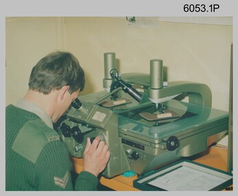
... AUTOMAP 2 Graphic Edit Workstation, L to R: unidentified, SPR Peter Smyth, SPR Frank Savy, SPR Quentin Seecamp, CPL Steve McGuiness in Cartographic Squadron. Army Survey Regiment Map Production Equipment Photograph Army Survey Regiment Map Production Equipment Army Survey Regiment ...Photos .1P, .2P, and.4P were most likely taken in the 1980s and photos .3P, .5P to .8P in the c1990s at the Army Survey Regiment, Fortuna, Bendigo. Despite lacking annotation on exact dates, locations and personnel, they are positively identified. CPL Ian Nelson in photo .1P is operating a Wild Pug 4 point transfer device in Air Survey Squadron c1980s. Control points were transferred onto the mapping diapositives of aerial photography by drilling their locations into the photographic emulsion. SPR Viv (Hawkins) Doherty in photo .2P, SPR Jeanette Drury-Lane in photo .5P and SGT Sandy Craig are operating a Wild B8 Stereoplotter coupled to a digital workstation in Air Survey Squadron c1994. Topographic features were extracted with the B8 in 3D and feature coded with attributes, using keyboard, menu, keypad and voice inputs to the computer. The features were stored in the AUTOMAP 2 digital database for subsequent cartographic production and printing. CPL Mick Ellis in photo .3P is operating the Optronix 4040 Scanner/Film Writer in Lithographic Squadron c1990s. In scanning mode, compilation sheets were mounted on the drum and scanned. The resultant raster file was vectorized, feature coded with attributes and stored by cartographic technicians in the AUTOMAP 2 database. In film writing mode, digital cartographic files were output at very high resolution for each print colour on photosensitive film, for subsequent finalisation, platemaking and printing.This is a set of eight photographs of technicians operating map production equipment at the Army Survey Regiment, Bendigo. The photographs were printed on photographic paper and are part of the Army Survey Regiment’s Collection. The photographs were scanned at 300 dpi. Photo negatives were scanned at 2400 dpi. .1) - Photo, colour, c1980s. CPL Ian Nelson operating a Wild Pug 4 point transfer device in Air Survey Squadron. .2) - Photo, colour, c1980s. Wild B8 Aviograph stereoplotter feature extraction, SPR Viv (Hawkins) Doherty in Air Survey Squadron. .3) - Photo, colour, c1990s. CPL Mick Ellis operating the Optronics 4040 Scanner in Lithographic Squadron. .4) - Photo, colour, c1984. AUTOMAP 2 Graphic Edit Workstation, SPR Craig Kellet in Cartographic Squadron. .5) - Photo, colour, c1994. Wild B8 Aviograph stereoplotter feature extraction, SPR Jeanette Drury-Lane in Air Survey Squadron. .6) - Photo, colour, c1994. AUTOMAP 2 Graphic Edit Workstation, L to R: unidentified, SPR Rachel (Stanford) Scott, CPL Chris Wynn in Cartographic Squadron. .7) - Photo, colour, c1994. Wild B8 Aviograph stereoplotter AUTOMAP 2 Graphic Edit Workstation, L to R: unidentified (x2), SGT Sandy Craig in Air Survey Squadron. .8) - Photo, colour, c1994. AUTOMAP 2 Graphic Edit Workstation, L to R: unidentified, SPR Peter Smyth, SPR Frank Savy, SPR Quentin Seecamp, CPL Steve McGuiness in Cartographic Squadron. .1P – no annotations .2P – annotated “Stereoplotter Workstation. The operator has the use of keyboard, menu, keypad and voice for input to the computer. Feedback is given through voice and screen messages.” .3 to .8P – no annotationsroyal australian survey corps, rasvy, army survey regiment, army svy regt, fortuna, air survey, litho, aerotrig, automap 2 -
 Bendigo Military Museum
Photograph - Photographic Technicians performing tasks at the Army Headquarters Survey Regiment, c1960s
... The AHQ Survey Regt also assists Commonwealth and other Govt departments in the printing of maps required other than for Army needs. The KLIMSCH camera is used for cartographic mapping photography.” ...The AHQ Survey Regt also assists Commonwealth and other Govt departments in the printing of maps required other than for Army needs. The KLIMSCH camera is used for cartographic mapping photography.” ...These eight photographs were most likely taken in the 1960s in Lithographic Squadron at the Army Headquarters Survey Regiment, Fortuna, Bendigo. Although Photo .1P is not annotated the remainder have the name of the technicians written on the back. The equipment operated by the technicians is the KLIMCH Commodore camera. The main tasks undertaken by the technicians were most likely enlargements and reductions of map reproduction material. The KLIMSCH Commodore camera was introduced in 1953 and was the largest in the Southern Hemisphere. It was replaced with a new model of the same size in 1979. The new model with its computer-based interface provided productivity gains with improved speed and its consistent results led to less wastage in time and materials. Its variomat lens system provided improved retention of map feature linear weights during the camera reduction process. The typed description pasted on the back of photo .5P states “Cpl R. MacKenzie of Bentley, Perth (WA) of the AHQ Survey Regt, located at “Fortuna”, Bendigo, (Vic). Has been in the Army for 5 years. He removes the lens cap from the 70 inch F16 lens of the giant KLIMSCH camera used in map making for the Army. The camera which was specially made for the Army in Germany is fully automatic and power operated. It is claimed to be one of the biggest automatic cameras of its type in the world. It was made to the specifications of the Aust Army Survey Corps to assist in the production of the very high standard maps for the Army. The AHQ Survey Regt also assists Commonwealth and other Govt departments in the printing of maps required other than for Army needs. The KLIMSCH camera is used for cartographic mapping photography.” This is a set of photographs of technicians operating photographic reproduction equipment at the Army Headquarters Survey Regiment, Bendigo c1960s. The photographs were printed on photographic paper and are part of the Army Survey Regiment’s Collection. The photographs were scanned at 300 dpi. .1) - Photo, black & white, c1960s, Les ‘Snow’ Taylor, Lithographic Squadron .2) - Photo, black & white, c1960s, Les ‘Snow’ Taylor, Lithographic Squadron .3) - Photo, black & white, c1960s, John Rolfe, Lithographic Squadron .4) - Photo, black & white, c1960s, John Rolfe, Lithographic Squadron .5) - Photo, black & white, c1960s, CPL R. MacKenzie, Lithographic Squadron .6) - Photo, black & white, c1960s, unidentified, Lithographic Squadron .7) - Photo, black & white, c1960s, George Graham, Lithographic Squadron .8) - Photo, black & white, c1960s, L to R: Bill Snelson, George Graham, Lithographic Squadron.1P – no annotation .2 to .4 – personnel names (less rank) annotated on back. .5 – name and rank annotated on back, with detailed typed description .6 to .8 – personnel names (less rank) annotated on back. royal australian survey corps, rasvy, army survey regiment, army svy regt, fortuna, asr, litho -
 Bendigo Military Museum
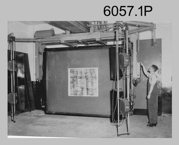
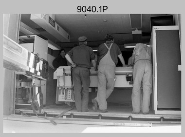
Photograph - Removal of AUTOMAP 1’s Gerber Optical Line Following (OLF) scanner from Army Survey Regiment, Fortuna, Bendigo, c1982-1983
... Introduced in 1975, the AUTOMAP 1 computer assisted cartography and mapping system was the first computer assisted cartography and mapping system utilised by the Survey Corps and the first system used by Australian mapping organisations. The Gerber OLF scanner was mainly used to digitise contours on a map sheet separation with individual lines at least 0.125 mm wide and no closer than 0.25 mm to the next line. ...Introduced in 1975, the AUTOMAP 1 computer assisted cartography and mapping system was the first computer assisted cartography and mapping system utilised by the Survey Corps and the first system used by Australian mapping organisations. The Gerber OLF scanner was mainly used to digitise contours on a map sheet separation with individual lines at least 0.125 mm wide and no closer than 0.25 mm to the next line. ...This collection of eight photos was most likely taken in circa 1982-1983, featuring the removal of AUTOMAP 1’s Gerber Optical Line Following (OLF) scanner Sub-System from Air Survey Squadron’s Building 16, in preparation for the installation of the replacement AUTOMAP 2 system. Introduced in 1975, the AUTOMAP 1 computer assisted cartography and mapping system was the first computer assisted cartography and mapping system utilised by the Survey Corps and the first system used by Australian mapping organisations. The Gerber OLF scanner was mainly used to digitise contours on a map sheet separation with individual lines at least 0.125 mm wide and no closer than 0.25 mm to the next line. The operator initiated the OLF by placing its light sensitive digitizing head on a contour line. The OLF could digitise up to 50 mm per second on straight lines and complete an average density contour sheet in approximately 8 hours. The operator occasionally intervened to restart the OLF to allow it to continue if it failed to correctly discriminate the contours. The history of the AUTOMAP 1 system is covered in more detail with additional historic photographs, in pages 116-118 of Valerie Lovejoy’s book 'Mapmakers of Fortuna – A history of the Army Survey Regiment’ ISBN: 0-646-42120-4. See items 6122.20P, 6183.19P, and 6184.20P for additional photographs of AUTOMAP 1’s Gerber OLF in operation.This is a set of eight photographs of the removal of AUTOMAP 1’s Gerber Optical Line Following (OLF) scanner Sub-System from Air Survey Squadron’s Building 16, at the Army Survey Regiment at Fortuna, Bendigo, circa 1982-1983. The photographs are on 35mm negative film and scanned at 96 dpi. They are part of the Army Survey Regiment’s Collection. .1) to .8) - Photo, black & white, c1982-1983, - Gerber Optical Line Follow (OLF) removal from Air Survey Squadron’s Building 16..1P to .8P – There are no annotationsroyal australian survey corps, rasvy, fortuna, army survey regiment, automap 1 -
 Bendigo Military Museum
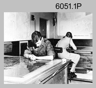
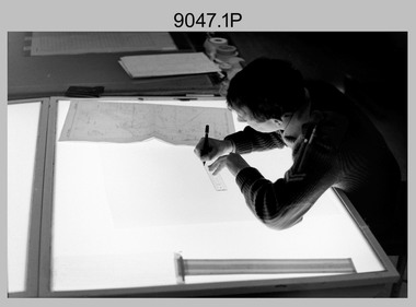
Photograph - Army Survey Regiment – Map Production, Fortuna, Bendigo, Army Survey Regiment – Map Production, Fortuna, Bendigo, c1990
... This is a set of five photograph of technicians performing map production tasks at the Army Survey Regiment, Fortuna, Bendigo, circa 1990. Photos .1P to .4P were taken either in Air Survey Squadron or Cartographic Squadron....Bendigo Military Museum 37 - 39 Pall Mall Bendigo goldfields This is a set of five photograph of technicians performing map production tasks at the Army Survey Regiment, Fortuna, Bendigo, circa 1990. Photos .1P to .4P were taken either in Air Survey Squadron or Cartographic Squadron. ...This is a set of five photograph of technicians performing map production tasks at the Army Survey Regiment, Fortuna, Bendigo, circa 1990. Photos .1P to .4P were taken either in Air Survey Squadron or Cartographic Squadron.This is a set of five photograph of Map Production performed at the Army Survey Regiment, Fortuna, Bendigo, c1990. The photographs are on 35mm negative film and scanned at 96 dpi. They are part of the Army Survey Regiment’s Collection. .1) to .3) - Photo, black & white, c1990, CPL Greg Honan transfers map annotations from a field check map sheet to a master compilation sheet using a Rotring Isograph ink pen. .4) - Photo, black & white, c1990, SPR Mick Arnott verifies features in 3D with a Casella stereoscope on an overlapped pair of aerial photographs. .5) - Photo, black & white, c1990, SGT Sherri (Dally) Burke working in the AUTOMAP 2 system. .1P to .5P – There are no annotationsroyal australian survey corps, rasvy, fortuna, army survey regiment, automap 2 -
 Bendigo Military Museum
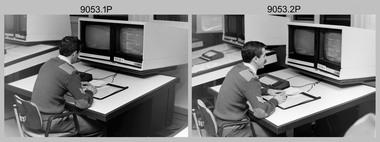
Photograph - AUTOMAP 2 Production - Army Survey Regiment, Fortuna, Bendigo, c1992
... This collection of 16 photos of map production on the AUTOMAP 2 computer-based system in Air Survey and Cartographic Squadrons, was most likely taken in circa 1992. ...Bendigo Military Museum 37 - 39 Pall Mall Bendigo goldfields This collection of 16 photos of map production on the AUTOMAP 2 computer-based system in Air Survey and Cartographic Squadrons, was most likely taken in circa 1992. ...This collection of 16 photos of map production on the AUTOMAP 2 computer-based system in Air Survey and Cartographic Squadrons, was most likely taken in circa 1992. The AUTOMAP 2 system was an upgrade to the AUTOMAP 1 system, comprising Intergraph graphic edit workstation terminals networked to VAX 750/785 main frame computers. Unlike AUTOMAP 1, operators could display digital topographic features on monitors for editing. Successful adaptation of this system meant RASvy was at the forefront of digital mapping/cartographic systems in Australia and overseas. The system comprised Input (Wild B8 Aviograph feature extraction) Raster Scanning (digitising from compilation sheets, Graphic Edit (cartographic completion) and Plot Verification Sub Systems. The system was operational from 1984 to its ‘Newheart’ upgrade in 1993. Throughout its life, the system was progressively refined with productivity gains, achieved from award winning technical development in-house by talented and innovative Army Survey Regiment personnel. See Item 6223.23P for more photos of AUTOMAP 2 production. This is a set of 16 photograph of AUTOMAP 2 production at the Army Survey Regiment at Fortuna, Bendigo, c1992. The photographs are on 35mm negative film and scanned at 96 dpi. They are part of the Army Survey Regiment’s Collection. .1) to .3) - Photo, colour, c1992, AUTOMAP 2 Graphic Edit Workstation, SGT Rick van der Bom. .4) - Photo, colour, c1992, AUTOMAP 2 Benson 5342 verification plotter. .5) - Photo, colour, c1992, AUTOMAP 2 Intergraph verification plotter. .6) & .7) - Photo, colour, c1992, AUTOMAP 2 Graphic Edit Workstation, SGT Phil Smalley. .8) - Photo, colour, c1992, AUTOMAP 2 Mapsetter Scanner/Plotter Workstation, SPR Ken Labouchardiere. .9) - Photo, colour, c1992, AUTOMAP 2 Mapsetter 4900 Scanner/Plotter. .10) - Photo, colour, c1992, AUTOMAP 2 Graphic Edit Workstation, CPL Mick McConnell. .11) - Photo, colour, c1992, AUTOMAP 2 Graphic Edit Workstation, CPL Peter Smyth. .12) - Photo, colour, c1992, AUTOMAP 2 Graphic Edit Workstation, SPR Annette (Odgers) Wynn. SGT Sherri (Dally) Burke in background. .13) - Photo, colour, c1992, AUTOMAP 2 Graphic Edit Workstation, SPR Rachel (Stanford) Scott. .14) - Photo, colour, c1992, AUTOMAP 2 Graphic Edit Workstation, unidentified technician. .15) - Photo, colour, c1992, AUTOMAP 2 Graphic Edit Workstation, SPR Bob Bousfield. .16) - Photo, colour, c1992, AUTOMAP 2 Stereo Workstation, CPL Brian Johnson..1P to .16P – There are no annotationsroyal australian survey corps, rasvy, fortuna, army survey regiment, automap 2 -
 Bendigo Military Museum
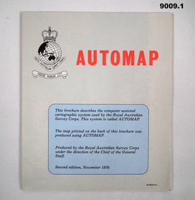
Map - Army Survey Regiment - Automap, Army Survey Regiment, Bendigo, 1 Nov 1979, .2 and .3 Aug 1980 and .4 December 1982
... maps using that digital data. The existing system, AUTOMAP 1, provides a small part of such a system. AUTOMAP 2 expands the capabilities of AUTOMAP 1 in data capture, computing power and data handling for cartographic purposes. ...maps using that digital data. The existing system, AUTOMAP 1, provides a small part of such a system. AUTOMAP 2 expands the capabilities of AUTOMAP 1 in data capture, computing power and data handling for cartographic purposes. ...These flow diagrams and in particular the Introduction to Automap 2 booklet is designed to provide a general description of the second phase of the AUTOMAP system (Automap 2) installed at the Army Survey Regiment, Bendigo. It contains information that managers and supervisors need to know and serves as a preliminary introduction for anyone interested in learning about AUTOMAP 2. In addition, a number of annexes are included to provide more detailed descriptions of significant features and components of the system. System Objectives. In order that RASVY can carry out its mapping programme effectively, an efficient production system is required that can acquire and edit digital data from a topographic data base and thence automatically produce high quality maps using that digital data. The existing system, AUTOMAP 1, provides a small part of such a system. AUTOMAP 2 expands the capabilities of AUTOMAP 1 in data capture, computing power and data handling for cartographic purposes. AUTOMAP 2 includes state-of-the-art technology, introduces interactive graphics as a production tool and shifts procedures from a current mix of analogue and digital technologies to an almost totally digital system. AUTOMAP 2 increases map production by at least 20 percent at the Army Survey Regiment. Project References. A wide range of user manuals and associated documentation is available for both the hardware and software components of the AUTOMAP system. Other related departmental references are listed at the rear of the booklet..1 A folded Automap produced Map, Derby 1:100 000, Series 1611, Sheet 3663, Printed on one side and Automap flow diagram second Edition DEF/MISC/5157 on the other side. .2 and .3 Two copies of a folded Automap produced Map, Yampi 1:250 000, Series 1501 (Joint Operations Graphic), Sheet SE51-3, Edition 1, Printed on one side and Automap flow diagram third Edition DEF/MISC/5157C on the other side. .4 An Introduction to the Automap 2 System, A4 Booklet 16 x pages and a folded Automap2 flow diagram fifth Edition DEF/MISC/5157E Annex in the rear of the booklet..1 DEF/MISC/5157 .2 AND .3 DEF/MISC/5157C .4 DEF/MISC/5157Eroyal australian survey corps, rasvy, fortuna, army survey regiment, army svy regt, asr -
 Bendigo Military Museum
Administrative record - International Map of the World (IMW) 1:1 Million Scale - H Ureta, Circa 1964, MR H Ereta, Post 1964
... This document records the history of the International Map of the World (IMW) at 1:1Million Scale. Mr H. Ereta, Chief of the Cartographic Section of the United Nations Department of Economic Development and Social Affairs gave a lecture on the IMW and described the history and development of the map series in post 1964. ...Bendigo Military Museum 37 - 39 Pall Mall Bendigo goldfields This document records the history of the International Map of the World (IMW) at 1:1Million Scale. Mr H. Ereta, Chief of the Cartographic Section of the United Nations Department of Economic Development and Social Affairs gave a lecture on the IMW and described the history and development of the map series in post 1964. ...This document records the history of the International Map of the World (IMW) at 1:1Million Scale. Mr H. Ereta, Chief of the Cartographic Section of the United Nations Department of Economic Development and Social Affairs gave a lecture on the IMW and described the history and development of the map series in post 1964. This document is a copy of that lecture. 7 x Foolscap pages of typed text, stapled and two hole punched, Paper is dis-coloured.royal australian survey corps, rasvy, fortuna, army survey regiment, army svy regt, asr, imw -
 Bendigo Military Museum
Administrative record - Army Survey Regiment - Operation Rapid Track 1987 Operation Report, Army Survey Regiment, Bendigo, 27 May 1987
... The Survey Operation Report deals with the cartographic completion of four 1:50,000 topographical line maps and one Special 1:50,000 map covering the Puckapunyal Military Training Area. ...Bendigo Military Museum 37 - 39 Pall Mall Bendigo goldfields The Survey Operation Report deals with the cartographic completion of four 1:50,000 topographical line maps and one Special 1:50,000 map covering the Puckapunyal Military Training Area. ...The Survey Operation Report deals with the cartographic completion of four 1:50,000 topographical line maps and one Special 1:50,000 map covering the Puckapunyal Military Training Area. The report covers in detail the digital stereo plotting, field completion (checking) and the cartographic completion including printing. The four 1:50.000 maps are 7823-1 PYALONG, 7824-2 COSTERFIELD, 7923-4 TALLAROOK and 7924-3 NAGAMBIE. Annex A lists personnel and dates involved and is attached as 6385.2. Annex B lists the members of the field completion parties.A4 sized buff coloured light cardboard covered report, plastic spiral binding. Front cover includes text, Survey Corps badge and light brown image of a Centurian tank. "To Tech Library", Page 2 has two small handwritten notes indicating that Phase 2 was the Field Completion Phaseroyal australian survey corps, rasvy, fortuna, army survey regiment, army svy regt, asr -
 Bendigo Military Museum
Photograph - Army Survey Regiment – Map Production, Fortuna, Bendigo, 1986
... These 17 photographs of the Army Survey Regiment’s map production and facilities were taken at Fortuna Villa, Bendigo, April 1986. Photos .1P to .3P were taken in Cartographic Squadron’s Correcting Section in the Attic. located on the top floor of Fortuna Photos .4P to .5P were taken in Cartographic Squadron’s Proving Section, located in the Ballroom also on the top floor facing the lake. ...Bendigo Military Museum 37 - 39 Pall Mall Bendigo goldfields These 17 photographs of the Army Survey Regiment’s map production and facilities were taken at Fortuna Villa, Bendigo, April 1986. Photos .1P to .3P were taken in Cartographic Squadron’s Correcting Section in the Attic. located on the top floor of Fortuna Photos .4P to .5P were taken in Cartographic Squadron’s Proving Section, located in the Ballroom also on the top floor facing the lake. ...These 17 photographs of the Army Survey Regiment’s map production and facilities were taken at Fortuna Villa, Bendigo, April 1986. Photos .1P to .3P were taken in Cartographic Squadron’s Correcting Section in the Attic. located on the top floor of Fortuna Photos .4P to .5P were taken in Cartographic Squadron’s Proving Section, located in the Ballroom also on the top floor facing the lake. The technicians were probably involved in a rapid response map production, as they all were wearing field uniforms. As ‘Regiment Overcrowding’ is annotated on the plastic sleeve holding the negatives, it seems the photos were taken when the unit was at its capacity to demonstrate the lack of suitable work areas. The Army Survey Regiment’s Duty Room, RAP and Carpark appearing in Photo .10P was probably taken from the top steps near the SGT’s accommodation block. Two of the photos in this set are also published in item 6096.5P.This is a set of 17 photograph of Map Production and car park was taken at the Army Survey Regiment, Fortuna, Bendigo, in April 1986. The black & white photographs are on 35mm negative film and are part of the Army Survey Regiment’s Collection. The photographs were scanned at 96 dpi. .1) - Photo, black & white, 1986. Correcting Section, Attic: L to R: CPL Andy Lucas, SPR Chris Gordon, unidentified, SPR Jan (Crighton) Minchin, CPL Robin Marshall, CPL Frank Downie, SPR Gayle Humphrey, unidentified (x2), Jason Wells at rear. .2) - Photo, black & white, 1986. Correcting Section, Attic: L to R: CPL Andy Lucas, SPR Chris Gordon, unidentified, SPR Jan (Crighton) Minchin, CPL Robin Marshall, CPL Frank Downie, SPR Gayle Humphrey, unidentified, Jason Wells, unidentified. .3) - Photo, black & white, 1986. Correcting Section, Attic: L to R: CPL Andy Lucas, CPL Robin Marshall, SPR Chris Gordon, unidentified, CPL Frank Downie, SPR Gayle Humphrey, unidentified, SPR Jan (Crighton) Minchin at rear., Jason Wells on phone. .4) & .5) - Photo, black & white, 1986. Proving Section, Ballroom: On left front to back: SGT Alan Staley, SGT Roger Rees, SGT Greg Anderson. On right front to back: SGT Denis McCarthy, SGT Tim Allanson, SSGT Adrian ‘Charlie’ Creedy. .6) - Photo, black & white, 1986. Records & Proofing buildings. .7) - Photo, black & white, 1986. Technical Services temporary buildings. .8) - Photo, black & white, 1986. Q-store and transport buildings. .9) - Photo, black & white, 1986. Technical Services temporary buildings in front of transport compound. .10) - Photo, black & white, 1986. Army Survey Regiment Duty Room, RAP and Carpark at Fortuna. .11) - Photo, black & white, 1986. Records & Proofing buildings. .12) - Photo, black & white, 1986. Other Ranks (OR’s) car park and barracks with kitchen in background. .13) - Photo, black & white, 1986. Other Ranks kitchen, parade ground and SGT’s/Officers barracks in background. .14) - Photo, black & white, 1986. Fortuna Villa taken from the steps near the SGT’s accommodation block. .15) - Photo, black & white, 1986. Fortuna Villa taken from the steps near the OR’s s accommodation block. .16) - Photo, black & white, 1986. Fortuna Villa taken from the roadway near the OR’s accommodation block. .17) - Photo, black & white, 1986. 20’ x 30’ Army tents set up on the basketball court..1P to .17P – ‘Regiment Overcrowding’ and the date are annotated on the plastic sleeve.royal australian survey corps, rasvy, army survey regiment, army svy regt, fortuna, asr -
 Bendigo Military Museum
Administrative record - DIGO Map Library and Repromat Review 2004, Geospatial Analysis Centre, Bendigo, 25 Oct 2004
... Cartographic Company at Fortuna in 1942 the repromat for all products produced by the Australian Survey Corps were carefully stored. With the disbandment of the Army Survey Regiment in 1996 the Defence Imagery and Geospatial Organisation (DIGO) inherited that repromat archive. It was immanent that the support for film based printing was ending so on 25 October 2004 a review was required to determine the way ahead for the repromat and paper maps...Cartographic Company at Fortuna in 1942 the repromat for all products produced by the Australian Survey Corps were carefully stored. With the disbandment of the Army Survey Regiment in 1996 the Defence Imagery and Geospatial Organisation (DIGO) inherited that repromat archive. It was immanent that the support for film based printing was ending so on 25 October 2004 a review was required to determine the way ahead for the repromat and paper maps ...Prior to the digital revolution the only medium by which cartographic information could be reproduced and distributed on mass was via printed media. The final negatives (repromat) used to produce the printed products were the culmination of a complex cartographic process and were therefore carefully preserved and stored. Preservation of the so-called final negatives enabled subsequent reprinting with minimal cartographic intervention. Since the arrival of the Land Headquarters Cartographic Company at Fortuna in 1942 the repromat for all products produced by the Australian Survey Corps were carefully stored. With the disbandment of the Army Survey Regiment in 1996 the Defence Imagery and Geospatial Organisation (DIGO) inherited that repromat archive. It was immanent that the support for film based printing was ending so on 25 October 2004 a review was required to determine the way ahead for the repromat and paper maps stored in the DIGO Map Libraries. Most of these maps were produced by the Royal Australian Survey Corps. This report is the result of that review. The report recommends the disposal of the repromat and the retention of single map copies. A4 plastic covered report, plastic clip bound, front page clear and rear page red. 9 x page document about the future of repromat and map printing.royal australian survey corps, rasvy, fortuna, army survey regiment, army svy regt, asr -
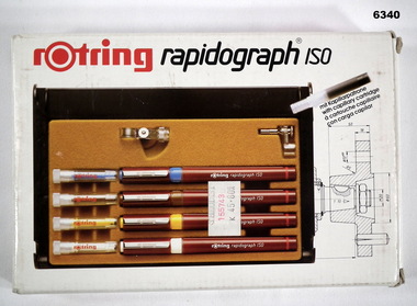 Bendigo Military Museum
Equipment - Rotring Rapidograph Iso Pen set, Circa 1980
... map overlay production. These pens produced lines of consistent line widths for cartographic ink work and these replaced the earlier "Crow Quill" ink nib pens. ...map overlay production. These pens produced lines of consistent line widths for cartographic ink work and these replaced the earlier "Crow Quill" ink nib pens. ...Used extensively within the Royal Australian Survey Corps for the compilation of maps and for map overlay production. These pens produced lines of consistent line widths for cartographic ink work and these replaced the earlier "Crow Quill" ink nib pens. These pens were donated by 310762 WO1 PJ Presser (dec) who served in the Royal Australian Survey Corps from 11 Feb 1970 - 12 Feb 1990.Rotring box Rapidograph Iso pen set with four pens in a plastic case and two compass adaptors. Pen sizes: 0.25mm, 0.35mm, 0.50mm, 0.70mm, with instructionsroyal australian survey corps, rasvy, fortuna, army survey regiment, army svy regt, asr -
 Bendigo Military Museum
Administrative record - LHQ Cartographic Coy - Map Printing and Reprints 1 July 1942- 31 Dec 1947, LHQ Cartographic Coy, 1942-1947
... The Land Headquarters Cartographic Company relocated to Fortuna Villa, Bendigo in 1942. With printing presses acquired from a number of civilian organizations it printed the maps needed for the Australian WW11 war effort. ...Photographs of the printing machines and the printers who used them are shown in Victorian Collections item 6148 LHQ Carto Coy Souvenir Booklet. 6352.1 Map Publishing and Reprinting Reports 1 July 1942 - 31 Dec 1943 6352.2 Map Publishing and Reprinting Reports 1 July 1943 - 31 Dec 1944 6352.3 Map Publishing and Reprinting Reports 1 July 1944 - 31 Dec 1945 6352.4 Map Publishing and Reprinting Reports 1 July 1945 - 31 Dec 1946 6352.5 Map Publishing and Reprinting Reports 1 July 1946 - 31 Dec 1947 Royal Australian Survey Corps RASvy Fortuna Army Survey Regiment Army Svy Regt ASR Hand written on the Folder covers: 6352.1 Map Publishing and Reprinting Reports 1 July 1942 - 31 Dec 1943 6352.2 Map Publishing and Reprinting Reports 1 July 1943 - 31 Dec 1944 6352.3 Map Publishing and Reprinting Reports 1 July 1944 - 31 Dec 1945 6352.4 Map Publishing and Reprinting Reports 1 July 1945 - 31 Dec 1946 6352.5 Map Publishing and Reprinting Reports 1 July 1946 - 31 Dec 1947 Five Manilla Folders containing Map Printing Reports LHQ Cartographic Coy - Map Printing and Reprints 1 July 1942- 31 Dec 1947 Administrative record LHQ Cartographic Coy - Map Printing and Reprints 1 July 1942- 31 Dec 1947 LHQ Cartographic Coy ...The Land Headquarters Cartographic Company relocated to Fortuna Villa, Bendigo in 1942. With printing presses acquired from a number of civilian organizations it printed the maps needed for the Australian WW11 war effort. These records detail which maps were printed during those years. Photographs of the printing machines and the printers who used them are shown in Victorian Collections item 6148 LHQ Carto Coy Souvenir Booklet. 6352.1 Map Publishing and Reprinting Reports 1 July 1942 - 31 Dec 1943 6352.2 Map Publishing and Reprinting Reports 1 July 1943 - 31 Dec 1944 6352.3 Map Publishing and Reprinting Reports 1 July 1944 - 31 Dec 1945 6352.4 Map Publishing and Reprinting Reports 1 July 1945 - 31 Dec 1946 6352.5 Map Publishing and Reprinting Reports 1 July 1946 - 31 Dec 1947Five Manilla Folders containing Map Printing ReportsHand written on the Folder covers: 6352.1 Map Publishing and Reprinting Reports 1 July 1942 - 31 Dec 1943 6352.2 Map Publishing and Reprinting Reports 1 July 1943 - 31 Dec 1944 6352.3 Map Publishing and Reprinting Reports 1 July 1944 - 31 Dec 1945 6352.4 Map Publishing and Reprinting Reports 1 July 1945 - 31 Dec 1946 6352.5 Map Publishing and Reprinting Reports 1 July 1946 - 31 Dec 1947royal australian survey corps, rasvy, fortuna, army survey regiment, army svy regt, asr