Showing 75 items matching "county of grant"
-
 Ballan Shire Historical Society
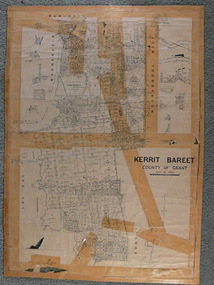
Map - Map. Kerrit Bareet, Department of Lands and Survey, Kerrit Bareet. County of Grant, 08/1944
... Kerrit Bareet. County of Grant....A map of the Kerrit Bareet area within the County of Grant showing properties and names of owners in 1944....A map of Kerrit Bareet in the County of Grant. Black printing on buff coloured paper. ...Kerrit Bareet. County of Grant. Map Map. Kerrit Bareet. Department of Lands and Survey. ...A map of the Kerrit Bareet area within the County of Grant showing properties and names of owners in 1944.Significant to people researching land usage and ownership. Also those researching families in the area at that time.A map of Kerrit Bareet in the County of Grant. Black printing on buff coloured paper. Details roads, rivers, railways, property boundaries and names of property owners and towns and villages. The map is easily readable although there is some physical damage and that and the borders have been reinforced with sellotape. Shows a Scale in Chains and Price 2/.gordon, bungal, kerrit bareet, lal lal, moorarbool river, warrenheip, bungaree, wallace, moorarbool west -
 Ballan Shire Historical Society
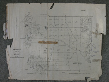
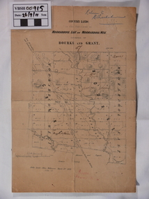
Map - Map. Ballark, Department of Lands and Survey, Ballark. County of Grant, 31/08/1915
... Ballark. County of Grant...A map of the Ballark area within the County of Grant showing roads, waterways, property boundaries and property owners in 1915....A map of Ballark in the County of Grant. Black printing on buff coloured paper. ...A map of Ballark in the County of Grant. Black printing on buff coloured paper. ...A map of the Ballark area within the County of Grant showing roads, waterways, property boundaries and property owners in 1915.Significant to people researching land usage and ownership. Also those researching families in the area at that time.A map of Ballark in the County of Grant. Black printing on buff coloured paper. Extra notations by hand and various coloured highlighting of certain features. Details roads, rivers, property boundaries and names of property owners and districts. The map is easily readable although there is some physical damage to the borders and some sellotape residue. Shows a scale in Chains and the number L.6030Various numbers and directional arrows added to map.bungal, borhoneyghurk, bungeeltap, ballark, beremboke, moreep, meredith, morrisons, moorarbool river -
 Federation University Historical Collection
Plan, Ballark: County of Grant, 05/01/1889
... Ballark: County of Grant...A geological plan of Ballark in the County of Grant....Barker Library (top floor) Mount Helen goldfields moreep mount wallace ballark A geological plan of Ballark in the County of Grant. Ballark: County of Grant Plan ...A geological plan of Ballark in the County of Grant.moreep, mount wallace, ballark -
 Federation University Historical Collection
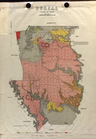
Map - Plan, E.J. Dunn, Bungal County of Grant Parish Plan
... Bungal County of Grant Parish Plan...Colour geological plan of Bungal in the County of Grant, Victoria. The areas circled in red ar craters....Bungal County of Grant Parish Plan Map Plan E.J. Dunn Geological Survey of Victoria State Regional Boundaries Committee Crown Lands and Survey ...E.J. Dunn was the surveyor of this parish plan.Colour geological plan of Bungal in the County of Grant, Victoria. The areas circled in red ar craters.plan, bungal, bungeltap, black horse co. egerton, egerton, mount egerton, sister rose shaft, south learmonth co, kerrit bareet, bungaeeltap, yaloak, eastern moorabool river, corong, bungal station preemptive right, lal lal, western moorabool river, moorabool rover, borhoneychurck, mount egerton battery, bungal creek -
 Federation University Historical Collection
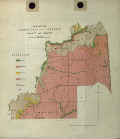
Plan - Map, Mines Department, Parish of Narmbool and part of Cargerie, County of Grant, 1892, 06/1992
... Parish of Narmbool and part of Cargerie, County of Grant, 1892...Geological map showing Narmbool and part of Cargerie in the County of Grant in five colours, predominantly pink....Parish of Narmbool and part of Cargerie, County of Grant, 1892 Plan Map Ferdinand M. Krause Mines Department Ferdinand M. ...This map shows the position of the homestead on the Narmbool Pre-emptive Right, volcanic craters, stock reserve, quarry and geological eras,Geological map showing Narmbool and part of Cargerie in the County of Grant in five colours, predominantly pink.narmbool, cargerie, narmbool pre-emptive right, williamson's creek, leigh river, green hill, collyer's hill, volcano, crater, krause, ferdinand krause -
 Buninyong & District Historical Society
Photograph - Black and white photograph of Plan of the Township of Buninyong, Plan of the Township of Buninyong in the County of Grant March 18 1856
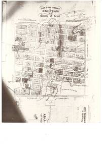
... Plan of the Township of Buninyong in the County of Grant March 18 1856..."Plan of the Township of Buninyong County of Grant", Surveyor Generals Office Melbourne 18th March 1856, various handwritten notations...A photograph of the Plan of the Township of Buninyong from the Surveyor Generals Office Melbourne March 1856 The map is one of the earliest of Buninyong and shows some notations indicating some allocations of land that were revoked and possibly the location of tannery dam Buninyong Township Maps "Plan of the Township of Buninyong County of Grant", Surveyor Generals Office Melbourne 18th March 1856, various handwritten notations A black and white photograph showing the Plan of the Township of Buninyong Plan of the Township of Buninyong in the County of Grant March 18 1856 Photograph Black and white photograph of Plan of the Township of Buninyong ...A photograph of the Plan of the Township of Buninyong from the Surveyor Generals Office Melbourne March 1856The map is one of the earliest of Buninyong and shows some notations indicating some allocations of land that were revoked and possibly the location of tannery damA black and white photograph showing the Plan of the Township of Buninyong"Plan of the Township of Buninyong County of Grant", Surveyor Generals Office Melbourne 18th March 1856, various handwritten notationsbuninyong township, maps -
 Bacchus Marsh & District Historical Society
Map, Gorrockburkchap Parish Map, County of Grant
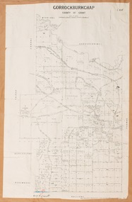
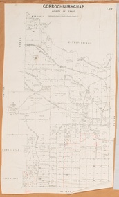
... Gorrockburkchap Parish Map, County of Grant...A single page paper map showing the parish plan for Gorrockburkchap in the County of Grant. The map is pasted into a bound volume containing 76 maps or plans in total. ...Gorrockburkchap Parish Map, County of Grant Map Shire of Bacchus Marsh ...The parish of Gorrockburkchap (sometimes spelled Gorrockburkghap) lies to the west and south west of the township of Bacchus Marsh. The locality of Rowsley is situated within this parish area.A single page paper map showing the parish plan for Gorrockburkchap in the County of Grant. The map is pasted into a bound volume containing 76 maps or plans in total. High resolution digital image stored on BMDHS computer network. gorrockburkchap parish maps, rowsley victoria maps -
 Bacchus Marsh & District Historical Society
Map, Gorrockburkchap Parish Map, County of Grant c.1915
... Gorrockburkchap Parish Map, County of Grant c.1915...A single page paper map showing the parish plan for Gorrockburkchap in the County of Grant. The map is pasted into a bound volume containing 76 maps or plans in total. ...Gorrockburkchap Parish Map, County of Grant c.1915 Map Shire of Bacchus Marsh ...The parish of Gorrockburkchap (sometimes spelled Gorrockburkghap) lies to the west and south west of the township of Bacchus Marsh. The locality of Rowsley is situated within this parish area.A single page paper map showing the parish plan for Gorrockburkchap in the County of Grant. The map is pasted into a bound volume containing 76 maps or plans in total. High resolution digital image stored on BMDHS computer network. gorrockburkchap parish maps, rowsley victoria maps -
 Bacchus Marsh & District Historical Society
Map, Mooradoranook Parish Map, County of Grant
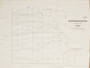
... Mooradoranook Parish Map, County of Grant...A single page paper map showing the map for the Parish of Mooradanook in the County of Grant. Cadastral map showing land ownership. ...Mooradoranook Parish Map, County of Grant Map Shire of Bacchus Marsh ...A single page paper map showing the map for the Parish of Mooradanook in the County of Grant. Cadastral map showing land ownership. The map is pasted into a bound volume containing 76 maps or plans in total. High resolution digital image stored on BMDHS computer network. Photo lithographed at the Department of Lands and Survey Melbourne by T. F. McGauran, 27.11.06mooradoranook parish maps, mooradoranook parish plan, bacchus marsh region parish plans -
 Bacchus Marsh & District Historical Society
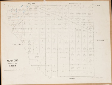
Map, Mouyong Parish Map, County of Grant
... Mouyong Parish Map, County of Grant...A single page paper map showing the map for the Parish of Mouyong in the County of Grant. Cadastral map showing land ownership. ...Mouyong Parish Map, County of Grant Map Shire of Bacchus Marsh ...A single page paper map showing the map for the Parish of Mouyong in the County of Grant. Cadastral map showing land ownership. The map is pasted into a bound volume containing 76 maps or plans in total. High resolution digital image stored on BMDHS computer network. Photo lithographed at the Department of Lands and Survey Melbourne by T. F. McGauran, 9. 4. 07mouyong parish plan, mouyong parish maps, bacchus marsh region parish plans -
 Ballan Shire Historical Society
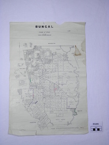
Map - Map. Bungal, Department of Lands and Survey, Bungal, County of Grant, 09/09/1926
... Bungal, County of Grant...Cream coloured map of Bungal in the County of Grant, bounded by the the East Moorarbool River on the East, and the State Forest on the South. ...It shows the land allotments with names of owners. Bungal, County of Grant Map Map. Bungal. Department of Lands and Survey. ...A map of Bungal in the 1920's showing the allotments, and the size, with the names of the residents. It shows the roads and the Western and Eastern Moorarbool River, and the Whipstick State Forest.Cream coloured map of Bungal in the County of Grant, bounded by the the East Moorarbool River on the East, and the State Forest on the South. It is marked with the scale of chains and the number L.358. Lithographed at the Department of Lands and Survey. Melbourne by W. J. Butson on 9.9.1926. It shows the land allotments with names of owners.Coloured pen marks and circled numbers on various areas. Price 2 shillings marked on bottom right hand edge.bungal, kerrit bareet, egerton, lal lal, borhoneyghurk, bungeeltap, ballark, yaloak, gorong, moorarbool west -
 Bacchus Marsh & District Historical Society
Map, Gorrockburkchap Parish Map, County of Grant c.1906
... Gorrockburkchap Parish Map, County of Grant c.1906...A single page paper map showing the parish plan for Gorrockburkchap in the County of Grant. A cadastral map showing parish boundaries and land ownership The map is pasted into a bound volume containing 76 maps or plans in total. ...Gorrockburkchap Parish Map, County of Grant c.1906 Map Shire of Bacchus Marsh ...The parish of Gorrockburkchap (sometimes spelled Gorrockburkghap) lies to the west and south west of the township of Bacchus Marsh. The locality of Rowsley is situated within this parish area.A single page paper map showing the parish plan for Gorrockburkchap in the County of Grant. A cadastral map showing parish boundaries and land ownership The map is pasted into a bound volume containing 76 maps or plans in total. High resolution digital image stored on BMDHS computer network. gorrockburkchap parish maps, rowsley victoria maps, bacchus marsh region parish plans -
 Bacchus Marsh & District Historical Society
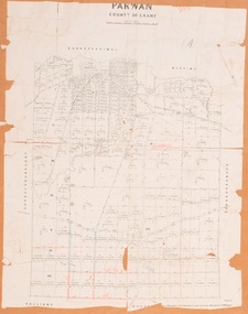
Map, Parwan Parish Map, County of Grant, 1909
... Parwan Parish Map, County of Grant, 1909...A single page paper map showing the map for the Parish of Parwan in the County of Grant. A cadastral map showing parish boundaries and land ownership. ...Parwan Parish Map, County of Grant, 1909 Map Shire of Bacchus Marsh ...A single page paper map showing the map for the Parish of Parwan in the County of Grant. A cadastral map showing parish boundaries and land ownership. The map is pasted into a bound volume containing 76 maps or plans in total. High resolution digital image stored on BMDHS computer network. Photo-lithographed at the Department of Lands and Survey, Melbourne by T.F. McGauran, 7.7.09. bacchus marsh region parish plans, parwan parish maps, parwan parish plan -
 Bacchus Marsh & District Historical Society
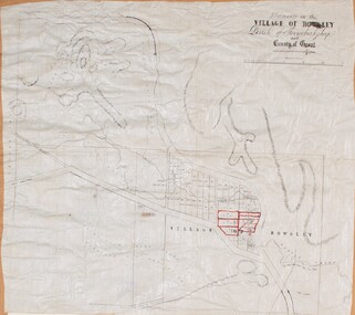
Map, Allotments in the Village of Rowsley, Parish of Gorrocburkghap, County of Grant c.1856
... Allotments in the Village of Rowsley, Parish of Gorrocburkghap, County of Grant c.1856...SLV reference: 'Allotments in the Village of Rowsley, Parish of Gorrocburkghap, County of Grant', by T. Nixon, Assistant Surveyor, May 1856 ; Surveyor General’s Office, July 18 1856 (lithographed by R. ...Allotments in the Village of Rowsley, Parish of Gorrocburkghap, County of Grant c.1856 Map Shire of Bacchus Marsh ...Rowsley is a locality 11 kilometers south-west of Bacchus Marsh. The date of this map is uncertain. A very similar map held by the State Library of Victoria (SLV) contains slightly more information than this copy and is dated as an 1856 map. SLV reference: 'Allotments in the Village of Rowsley, Parish of Gorrocburkghap, County of Grant', by T. Nixon, Assistant Surveyor, May 1856 ; Surveyor General’s Office, July 18 1856 (lithographed by R. Meikle). (1856). Melbourne: Surveyor General’s Office. MAPS 820 BJE 1837- ROWSLEY 1856. A single page paper map. A cadastral map of the Village of Rowsley in Victoria, showing numbered land allotments. 57 allotments are shown on the map and some areas set aside as reserves. Allotments 8, and 10-16 are outlined in red ink and allotment 9 has a cross in red ink on it. The map is pasted into a bound volume containing 76 maps or plans in total. High resolution digital image stored on BMDHS computer network. rowsley victoria history, rowsley victoria maps -
 Federation University Historical Collection
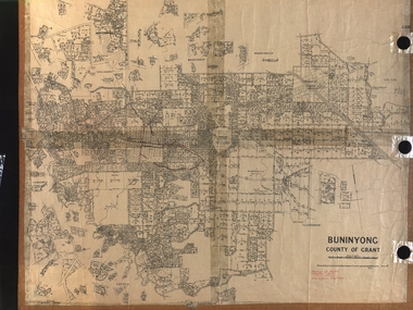
Plan, Department of Crown Lands and Survey, Melbourne, Buninyong County of Grant, 23/07/1929
... Buninyong County of Grant...Pisition of tracks in 1859 have been marked on the plan in red. Buninyong County of Grant Plan Department of Crown Lands and Survey, Melbourne ...The plan was photo-lithographed at the Departmen tof Lands and Survey, MelbourneA parish plan of Buninyong, including Robert Scott's Mt Buninyong Pre-emptive Right, Mt Buninyong Public Park, Thomas Learmonth's land, John Learmonth's land, Scotchan's, Yendon. The Buninyong POst Office is Allotment 1. Pisition of tracks in 1859 have been marked on the plan in red.buninyong, scotchman's, mt buninyong, robert scott, clarendon, lal lal creek, yendon, warrenheip, yarowee, enfield, thomas learmonth, john learmonth, archibald fisken, g. schloo, george innes, peter inglis, durham lead, j. fry, j. forrest, parkin lee, buninyong recreation reserve -
 Federation University Historical Collection
Plan, Parish of Lal-Lal County of Grant
... Parish of Lal-Lal County of Grant...Barker Library (top floor) Mount Helen goldfields lal lal mt doran lal lal racecourse geology geological Moorabool river Mount Duran Printed colour map on paper Parish of Lal-Lal County of Grant Plan ...Printed colour map on paperlal lal, mt doran, lal lal racecourse, geology, geological, moorabool river, mount duran -
 Bacchus Marsh & District Historical Society
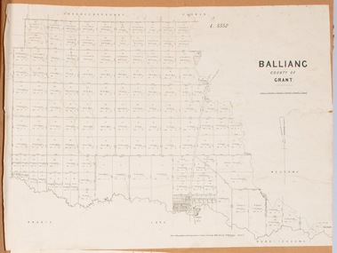
Map, Balliang Parish Map, County of Grant c.1907
... Balliang Parish Map, County of Grant c.1907...Balliang Parish Map, County of Grant c.1907 Map Shire of Bacchus Marsh ...A single page paper map showing parish plan map for Balliang. This parish area contains the localities of Balliang and Balliang East and is located south of the township of Bacchus Marsh. The map is pasted into a bound volume containing 76 maps or plans in total. High resolution digital image stored on BMDHS computer network. balliang victoria maps, balliang parish maps -
 Bacchus Marsh & District Historical Society
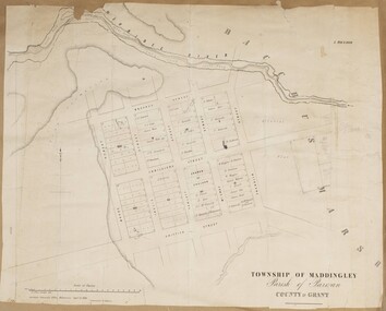
Map, Maddingley Township, Parish of Parwan, County of Grant, 1856
... Maddingley Township, Parish of Parwan, County of Grant, 1856...Maddingley Township, Parish of Parwan, County of Grant, 1856 Map Shire of Bacchus Marsh ...Maddingley is a locality or township within the broader township area of Bacchus Marsh. This map is dated 1856 but is based on an earlier survey in 1843. The main area of Maddingley shown on this map is an area bounded by Bacchus Street, Moore Street, Griffith Street and Franklin Street. Other streets visible are Inglis Street, Labilliere Street, McCrae Street. The area to the east of Franklin Street is not sub-divided and is described as an 'alluvial flat. A single page paper map showing land allotments, streets, and natural watercourses in the township of Maddingley. The map is pasted into a bound volume containing 76 maps or plans in total. Two inscriptions: 1. A.J. Skene Surveyor, 1843. ; 2. Surveyor-General's Office Melbourne, Sept 6, 1856. (Lithographed by R. Meikle)bacchus marsh victoria maps, maddingley victoria maps, land use, maddingley victoria history -
 Federation University Historical Collection
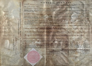
Document, Grant, by Purchase, Ballarat, Victoria, 1856, 1856
... ...county of grant...The land was in the County of Grant, Parish of Ballarat. Record of Register of Town Purchase, No. 50, Page 156 on 20 April 1856 and signed by William C Haines....The land was in the County of Grant, Parish of Ballarat. Record of Register of Town Purchase, No. 50, Page 156 on 20 April 1856 and signed by William C Haines. thomas bath county of grant parish of ballarat william c haines colonial secretary edward macarthur Official seal Dated 9 April 1856 Signed: E Macarthur - Major General Edward Macarthur Signed: William C Haines - Colonial Secretary Thick cream paper, badly stained. ...Thomas Bath of Ballarat became the purchaser of a parcel of land for the sum of Five Hundred Pounds. The land was in the County of Grant, Parish of Ballarat. Record of Register of Town Purchase, No. 50, Page 156 on 20 April 1856 and signed by William C Haines.Thick cream paper, badly stained. Hanad written Official seal Dated 9 April 1856 Signed: E Macarthur - Major General Edward Macarthur Signed: William C Haines - Colonial Secretarythomas bath, county of grant, parish of ballarat, william c haines, colonial secretary, edward macarthur -
 Federation University Historical Collection
Document, Declaration of Ernest by owners of land in Yendon being held as a site for Public Hall and Free Library; 1891, 1891
... ...county of grant...Land that had been purchased - being part of Crown Allotment Five Section six, Township of Buninyong East, Parish of Buninyong, County of Grant, has been purchased "as a site for a public hall and free library for the use and benefit of the inhabitants of the Township of Yendon."...Land that had been purchased - being part of Crown Allotment Five Section six, Township of Buninyong East, Parish of Buninyong, County of Grant, has been purchased "as a site for a public hall and free library for the use and benefit of the inhabitants of the Township of Yendon." declaration of ernest land title free library public hall yendon buninyong paris of buninyong county of grant john winterburn kemp philip ballantyne samuel henry mayo thomas dooley thomas watson Document stamped in green - 0122083 Signatures of; John Winterburn Kemp, Philip Ballantyne, Samuel Henry Mayo, Thomas Dooley, Thomas Watson Thick paper, hand written. ...Document outlining the agreement between five males, all residents of Yendon. Land that had been purchased - being part of Crown Allotment Five Section six, Township of Buninyong East, Parish of Buninyong, County of Grant, has been purchased "as a site for a public hall and free library for the use and benefit of the inhabitants of the Township of Yendon."Thick paper, hand written. Red dots indicate places for signatures Document stamped in green - 0122083 Signatures of; John Winterburn Kemp, Philip Ballantyne, Samuel Henry Mayo, Thomas Dooley, Thomas Watsondeclaration of ernest, land title, free library, public hall, yendon, buninyong, paris of buninyong, county of grant, john winterburn kemp, philip ballantyne, samuel henry mayo, thomas dooley, thomas watson -
 Federation University Historical Collection
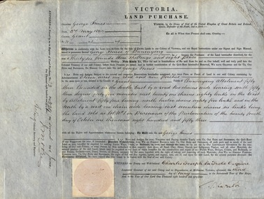
Document, Grant, by Purchase, to George Innes, 3 May 1854, 1854
... ...county of grant...George Innes purchased land in the County of Grant, Parish of Buninyong, for the sum of Thirty-six pounds, three shillings and eight pence. ...Barker Library (top floor) Mount Helen goldfields George Innes purchased land in the County of Grant, Parish of Buninyong, for the sum of Thirty-six pounds, three shillings and eight pence. ...George Innes purchased land in the County of Grant, Parish of Buninyong, for the sum of Thirty-six pounds, three shillings and eight pence. The price paid was for eleven acres one rood and nine perches. The document is witnessed by Charles Joseph La Trobe Esquire on 3 May 1854 in Melbourne. La Trobe was Lieutenant Governor of the Colony of VictoriaThick paper written on by hand. Top edge and right-hand corner damaged Dated 3 May 1854 Signature of Charles Joseph La Trobe and J Moorela trobe, lieutenant governor, george innes, county of grant, parish of buninyong, land purchase -
 Ballan Shire Historical Society
Map - Map. Moorarbool East and West, Country Lands in the Parishes of Moorarbool East and Moorarbool West. Counties of Bourke and Grant
... ...County of Bourke...County of Grant...This is a map of "Country Lands" around the Werribee River, north of Ballan in the Counties of Bourke and Grant....Ballan Shire Historical Society 45-47 Steiglitz St Ballan goldfields This is a map of "Country Lands" around the Werribee River, north of Ballan in the Counties of Bourke and Grant. moorarbool west moorarbool east dugald mcpherson County of Bourke County of Grant Werribee River Ballan There is a small inscription under the chain scale that reads "No 58/364 John Phillips ? ...This is a map of "Country Lands" around the Werribee River, north of Ballan in the Counties of Bourke and Grant.A relatively small map, paper on a material backing. Shows topographical features, roads and property divisions. Scale of forty chains to one inch. The map is dated March 31st, 1859.There is a small inscription under the chain scale that reads "No 58/364 John Phillips ? Survey 1st August 1858". The name Dugald McPherson is hand written on one of the blocks of land.moorarbool west, moorarbool east, dugald mcpherson, county of bourke, county of grant, werribee river, ballan -
 Federation University Historical Collection
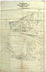
Plan, Ballaarat East Town Allotments, 1891, 18/09/1891
... Plan of Town Allotments for a portion of Ballarat East in the County of Grant. It shows Victoria Street, Clifford Street, Finlay Street, Ryan Street, Bradbury Street, Elford Street, Fussell Street, Jones Street, Park Parade, Ballarat -Geelong Railway, Eureka Street, Ballarat East Public Park Botanic Garden and Recreation Reserve. ...Elford Street now appears to be the continuation of Eureka Street. ballarat east ballaarat east victoria street ballarat east botanical gardens richard squire squire ryan street jones street bradbury street humffray steet fussell street elford street Plan of Town Allotments for a portion of Ballarat East in the County of Grant. It shows Victoria Street, Clifford Street, Finlay Street, Ryan Street, Bradbury Street, Elford Street, Fussell Street, Jones Street, Park Parade, Ballarat -Geelong Railway, Eureka Street, Ballarat East Public Park Botanic Garden and Recreation Reserve. ...Ballarat East was historically a separate municipality than Ballaarat. The streets developed along gold leads and early tracks. The Public Park Botanic Gardens and Recreation Reserve is now Mount Xavier Golf Course, and Ballarat Secondary College Eastern Campus. The section with Bettle's Private Property is now Saint Francis Xavier Primary School. Elford Street now appears to be the continuation of Eureka Street.Plan of Town Allotments for a portion of Ballarat East in the County of Grant. It shows Victoria Street, Clifford Street, Finlay Street, Ryan Street, Bradbury Street, Elford Street, Fussell Street, Jones Street, Park Parade, Ballarat -Geelong Railway, Eureka Street, Ballarat East Public Park Botanic Garden and Recreation Reserve. The only allotment names is Bettle's Private Property. Gift of the Squire Family, 2014ballarat east, ballaarat east, victoria street, ballarat east botanical gardens, richard squire, squire, ryan street, jones street, bradbury street, humffray steet, fussell street, elford street -
 Bendigo Historical Society Inc.
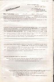
Document - MCCOLL, RANKIN AND STANISTREET COLLECTION: INDENTURE GOLD MINING LEASE 9201 BALLAARAT
... On map: Mining District of Ballarat, County of Grant, Parish of Moorarbool West. Total area: 285 acres 1 rood, 20 perches. ...On map: Mining District of Ballarat, County of Grant, Parish of Moorarbool West. Total area: 285 acres 1 rood, 20 perches. ...6 page document plus map: indenture, gold mining lease dated 9th August 1960, between the Crown and North Deborah Mining Company, carrying on operations in the Parish of Moorarbool West . Key on map indicates depth to which land may be excised. On map: Mining District of Ballarat, County of Grant, Parish of Moorarbool West. Total area: 285 acres 1 rood, 20 perches. Vol 334, Fol 202.bendigo, mining, deborah gold mines -
 Bacchus Marsh & District Historical Society
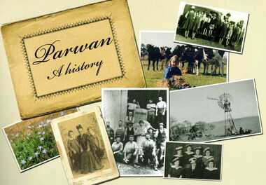
Book, Parwan: A History, 2010
... Includes a separate folded sheet inside a pocket which has a reproduction of a map of the Parwan Parish in the County of Grant. On the reverse of this sheet are two reproductions. ...Includes a separate folded sheet inside a pocket which has a reproduction of a map of the Parwan Parish in the County of Grant. On the reverse of this sheet are two reproductions. ...Explores the history of the small farming community on the outskirts of Bacchus Marsh. It contains a plethora of fascinating details about the early years of this farming community from the 1830s until the early 2000s. There is a brief section at the beginning which looks at the history of the area prior to the colonial era. The book contains numerous sections about families and individual people who have lived in the Parwan area and includes many images of places and people. Citation: Parwan: A History by Dianne Van Leuvan. Published by Parwan History Group, Bacchus Marsh, Vic., 2010.Paperback printed book. 128 pages. with illustrations and photographs, some coloured. Includes facsimiles, maps, and index. Includes a separate folded sheet inside a pocket which has a reproduction of a map of the Parwan Parish in the County of Grant. On the reverse of this sheet are two reproductions. One is a land auction plan for February 1910 advertising the sale of portions of land from the Nerowie Estate. The other reproduction is a section of a map showing some of the blocks of land in the Nerowie Estate which has the heading, 'Nerowie Titles 1898'. A pocket inside the back cover contains a separate booklet which is an index, and two pages of 'Additional Information'.non-fictionExplores the history of the small farming community on the outskirts of Bacchus Marsh. It contains a plethora of fascinating details about the early years of this farming community from the 1830s until the early 2000s. There is a brief section at the beginning which looks at the history of the area prior to the colonial era. The book contains numerous sections about families and individual people who have lived in the Parwan area and includes many images of places and people. Citation: Parwan: A History by Dianne Van Leuvan. Published by Parwan History Group, Bacchus Marsh, Vic., 2010.parwan vic. history -
 Federation University Historical Collection
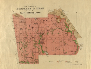
Plan, Bungaree and Dean Parish and Geological Plan, 1890, 07/1890
... Geological and Parish Map of parts of the Parishes of Bungaree and Dean in the Counties of Talbot, Grenville and Grant. The scale is 40 chains to one inch. ...Geological and Parish Map of parts of the Parishes of Bungaree and Dean in the Counties of Talbot, Grenville and Grant. The scale is 40 chains to one inch. ...Ferdinand M. Krause was a Professor at the Ballarat School of Mines.Geological and Parish Map of parts of the Parishes of Bungaree and Dean in the Counties of Talbot, Grenville and Grant. The scale is 40 chains to one inch. bungaree, deen, krause, f.m. krause, musk creek, clarkes hill, badger hill, beale's reservoir, acquainted. -
 Federation University Historical Collection
Booklet, Luplau, Hewood & Riderm Printers, The School of Mines Ballaarat Annual Report 1883, 1883
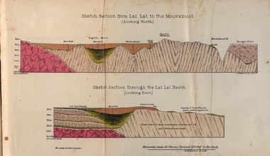
... Sketch Section from Lal Lal to the Moorabool (looking north) Geological map of Lal Lal. In the County of Grant. Annual Report, Balance Sheet, Certificates granted by the Council, Examination Papers - Elementary Science Classes (Appendix), Extracts from Visitors' Book, Fees, Form of Bequest, Honorary Correspondents. ...Sketch Section from Lal Lal to the Moorabool (looking north) Geological map of Lal Lal. In the County of Grant. Annual Report, Balance Sheet, Certificates granted by the Council, Examination Papers - Elementary Science Classes (Appendix), Extracts from Visitors' Book, Fees, Form of Bequest, Honorary Correspondents. ...The School of Mines Ballaarat. Annual Report 1883. Statement of Receipts and expenditure, general balance sheet, and list of subscriptions donations 1882. Sketch of School of Mines. Sketch Section from Lal Lal to the Moorabool (looking north) Geological map of Lal Lal. In the County of Grant. Annual Report, Balance Sheet, Certificates granted by the Council, Examination Papers - Elementary Science Classes (Appendix), Extracts from Visitors' Book, Fees, Form of Bequest, Honorary Correspondents. Life Governors, Museum - open to visitors, Notes on the Geology of Lal Lal (with Geological Plan & Sections), Obituary, Office Bearers, Paper of Particulars, Rules of the Ballaarat Field Club and Science Society (Appendix), Report of the Curator of the Museum and Library, Report of the Superintendent of Laboratories, Report of the Lecturer in Mathematics, Report of the Lecturer in Mechanical Engineering, Report of the Lecturer in Telegraphy, Report of the Lecturer in Materia Medica, Statement of Receipts and Expenditure for the year 1882, Subjects and Lectures, Subjects and Examiners, Subscriptions and Donations, from 1st January to 31st December 1882.Ballaarat School of Mines annual Report. Hard cover red book of 101 pages. Includes plans on Lal Lal and surrounds. ballarat school of mines, annual report, balance sheet, certificates granted by the council, examination papers, extracts from the visitors' book, fees, form of bequest, honorary correspondents, life governors, museum, notes on the geology of lal lal, obituary: charles william thomas. one of the examiners in mining and surveying, office bearers, paper of particulars, rules of the ballaarat field club and science society, report of the curator of the museum and library, report of the superintendent of laboratories, report of the lecturer in mathematics, report of the lecturer in mechanical engineering, report of the lecturer in telegraphy, report of the lecturer in materia medica, statement of receipts and expenditure for the year 1882, subjects and lectures, subjects and examiners, subcriptions and donations, from 1st january to 31st december 1882, alf. mica smith, professor of chemistry, alf. mica smith, metallurgy, f. m. krause - professor of geology, mineralogy, scientific mining, t. h. thompson, practical mining, w. h. shaw mechanical engineering, h. reid, mechanical enginnering, phoenix foundry company (limited), a. a. buley, mathematics, f. m. krause, land, mining and engineering surveying, w. d. campbell, telegraphy, james oddie, vice-president, alf. mica smith, natural philosophy (elementary mechanics and hydrostatics, magnetism and electricty, sound, light and heat), j. f. usher, materia medica, pharmacy and physiology, examiner, professor h. m. andrew, m. a., examiner, h. d. de la poer wall, m. a, c. e., examiner, thomas mann, b. a., examiner, p. c. fitzpatrick, c. s., examiner, h. rosale, j.p., f.g.s, m.e. and m, examiner, john lewis, examiner, w. c. kernot, m.a., c.e., examiner, professor mccoy, examiner, j. cosmo newbery, c.m.g., b. sc., examiner, baron von mueller, k.c.m.g., m. et ph. d., f. r.s., examiner, sam. w. macgowan, examiner, w. p. bechervaise, examiner, r. l. j. ellery, f.r.s. govt. astronomer, examiner, f. m. krause, c.e., examiner, j. m. bickett, examiner, n. kent, examiner, a. martin, examiner, r. s. mitchell, examiner, w. h. keast, examiner, p. matthews, examiner, d. milliken, examiner, j. t. richards, examiner, jonathan robinson, examiner, t. h. thompson, examiner, h. brookes allen, m.d., examiner, joseph bosisto, examiner, c. r. blackett, m.l.a., examiner, wm. johnson, analyst to the government of victoria, ferdinand krause, ballarat field naturalists club, ferdinand von mueller, thomas mann, a.a. buley, ferrdinand krause, alfred mica smith, james oddie, william johnson, jonathan robinson, james bickett, r.l.j. ellery, cosmo newbery, ballarat field naturalists -
 Bacchus Marsh & District Historical Society
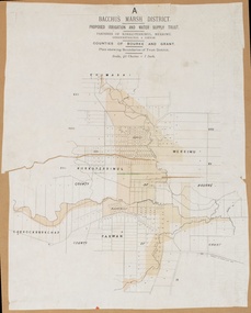
Map, Bacchus Marsh District (A). Proposed Irrigation and Water Supply Trust. Plan shewing boundaries of Trust District
... The District lies within the Parishes of Korkuperrimul, Merrimu, Parwan and Gorrockburkchap in the Counties of Bourke and Grant. At the top of the map above its title is the letter 'A; in capital lettering. ...The District lies within the Parishes of Korkuperrimul, Merrimu, Parwan and Gorrockburkchap in the Counties of Bourke and Grant. At the top of the map above its title is the letter 'A; in capital lettering. ...The 1886 Irrigation Act in Victoria introduced the first legislation in Australia designed to enable the creation of a detailed scheme for agricultural irrigation. Part of the legislation saw the use of government funds for local irrigation projects. These local projects were managed by local irrigation trusts. The Bacchus Marsh Irrigation and Water Supply Trust was formed in 1889. This map depicts the proposed area of the Trust.Printed paper map of the proposed Bacchus Marsh Irrigation and Water Supply district. Circa 1889. Plan showing boundaries of Trust District. The District lies within the Parishes of Korkuperrimul, Merrimu, Parwan and Gorrockburkchap in the Counties of Bourke and Grant. At the top of the map above its title is the letter 'A; in capital lettering. Scale: 40 Chains = 1 inch.irrigation, water supply, bacchus marsh irrigation and water supply trust -
 Eltham District Historical Society Inc
Folder, Unpublished collection of Eltham State School No. 209 items, 1856-1995 by Harry Gilham (EDHS)
... It was prepared to help celebrate the 140th year of the school's existence on its original land grant of 1856, which appeared on the first surveyed land for the formation of the Town of Eltham, in the Parish of Nillumbik, County of Evelyn, granted by the then Government of New South Wales. ...It was prepared to help celebrate the 140th year of the school's existence on its original land grant of 1856, which appeared on the first surveyed land for the formation of the Town of Eltham, in the Parish of Nillumbik, County of Evelyn, granted by the then Government of New South Wales. ...Contents 1. Draft chronology - Eltham Primary School Chronology 1856-1995; Harry Gilham (EDHS) 1995 127 pages, A4 photocopies This collection of memorabilia has a focus on the Eltham State School No. 209. It was prepared to help celebrate the 140th year of the school's existence on its original land grant of 1856, which appeared on the first surveyed land for the formation of the Town of Eltham, in the Parish of Nillumbik, County of Evelyn, granted by the then Government of New South Wales. It is inscribed in Harry Gilham's writing on page 1 - "For Eltham P.S Chronology 209 - 150th Anniv. book; Harry Gilham Collection; Unpublished" and stamped "Eltham District Historical Society" Pages 3 and 4 missing. This manuscript was a major source reference for the book "We Did Open A School In Little Eltham; Eltham Primary School 209, 1856-2006, A History" Source references from Inspector's Register of State Schools; photocopies held by EDHS in A3 binders 2. Renovation of Eltham Primary School Residence; Application of a Grant from National Estate Grants program, 17 April 1989 10 pages A4 photocopy 3. Wayfinding In The Environment; The role of aesthetics research in participatory planning design by Victoria Sharp for the School of Environmental Planning, The University of Melbourne, February 1987 4 pages, A4 photocopy extracts copied include: Synopsis Spefic Design Concerns p37 (relative to Eltham Gateway) Summary p38 4. File Record, State School No 209 - Eltham; National Trust of Australia File No B3260; 29 March 2000 1 page A4 5. Notes by Harry Gilham concerning Eltham State School No 209 1 page handwritten lined pad sheet 6. Notes by Harry Gilham concerning Eltham State School No 209 and feedback on 150th Anniversary book 1 page, A4 green 144 A4 pages As noted150th anniversary, chronology, eltham gateway, eltham primary school, eltham state school, harry gilham, national trust of australia, planning, renovation, school residence, state school no. 209, victoria sharp -
 Melton City Libraries
Document, Darlingsford land title, 1863
... Note: Map KOROROIT COUNTY OF BOURKE Crown Grant Section 11 Portion A Thomas. ...Note: Map KOROROIT COUNTY OF BOURKE Crown Grant Section 11 Portion A Thomas. ...Thomas Bell Darling purchased 176 acres from the Toolern Creek to Ferris Road. A house and bluestone barn/stables were built. The property was owned by Ralph Parkinson, followed by Richard Manning. SUMMARY – Darlingsford – Auction 1910 Darlingsford – Auction 1910 Melton Express October FRIDAY, October 28th At Three O’Clock At the RAGLAN HOTEL, MELTON SUBDIVISIONAL SALE of the DARLINGSFORD ESTATE, MELTON. Having a long frontage to the TOOLERN CREEK. In the Estate of the late RICHARD MANNING’ W. S. KEAST and L.A. FAIRBAIRN & CO., Auctioneers (in conjunction). Have received instructions from R.F. and J.L. Robertson, executors of Richard Manning deceased to offer by Public Auction, property almost adjoining Melton township, and having a frontage to the Toolern Creek, subdivided in to four lots as under:- Lot 1. – The homestead block containing 176 acres, being portion A, section 11, parish Kororoit together with the improvements, which consist of a 6-roomed stone house, milking shed, dairy, U.G. tank. Lot 2 – 177 acres 2 rood 23 perches, being Crown portion B of section 11 parish Kororoit. This block adjoins the homestead and is partly fenced. Lot 3 – 187 acres, Crown allotment C, section 11, parish Kororoit. adjoining the above lot. Lot 4 - 157 acres 1 rood 27 perches, being Crown allotment 9, section 12, parish of Kororoit. This block is only divided from the above lots by road, and adjoining Messrs. McVean and Gaitskill’s properties. This is one of the best known properties in the Melton district as a cultivation an grazing form, and its close proximity to the township makes it a very valuable, and portion of which could be cut into township blocks and should command a ready sale. For absolute sale. Terms- one fifth cash, one fifth in eight years, balance in 7 years with interest a the rate of 4 1/2 percent. Plan on application For further particulars apply W.S. KEAST, 610 Collins street, Melbourne; and L.A. FAIRBAIRN & Co., St James-buildings, Williams street, or at Bacchus Marsh; and as to the title, Dugdale and Creber, St. James-buildings, William Street Melbourne. Express November 5, 1910 On Friday last, Mr W.S. Keast and Messrs L.A. Fairbairn & Co., in conjunction, offered at the Raglan the Manning Estate known as Darlingsford, comprising of 700 acres, divided into four lots. Lot 4 was submitted first and passed in at L8 per acre. Lot 1 was then put up and went up to L13 per acre, at which it was also passed in. Lot 3 was next offered, and there being no bid was also passed in. Lot 2 was not offered. Express March 18, 1911 The Manning Estate of Darlingsford 600 acres was sold to Mr. Ernie for an undisclosed price. Note: Map KOROROIT COUNTY OF BOURKE Crown Grant Section 11 Portion A Thomas. B. Darling 176 . 0 . 0 acres on 29.3.1853 Lot 1 Portion B A. Russell 170 . 0 . 0 acres on 29.3.1853 Lot 2 Portion C Peter Inglis 176 . 0 . 0 acres on 29.3.1853 Lot 3 Section 12 Portion 3 P. Inglis 157 . 1 . 27 acres on 17.17.1863 Total 176 170 176 157. 1.27 679 . 1.27 acres November 5th 1910 On Friday night last Mr W S Keast and Messrs L A Fairbairn & Co, in conjunction offered at the Raglan Hotel the Manning Estate known as Darlingsford, comprising of 700 acres, divided into four Lots. Lot 4 was submitted first, and was passed in at L8.0.0. per acre. Lot 1 was then put up and went to L13.0.0. per acre at which it was passed in. Lot 3 was next offered, and then Lot 3 was next offered, and then being no bid was passed in. Lot 2 was not offered. October 22nd Notice of sale. 700 acres of splendid land close to the railway station. Divided onto 4 Lots 3 of which are maiden land and the whole of the acres is chocolate soil. No 1 Lot belonged to the late Mr Ralph Parkinson, and for years was liberally supplied with manure and crushed bones, and is capable of producing many crops.. The property being sold to wind up the Estate. Gisborne Gazette Friday December 17th 1911 Mr Sharp has sold his farm at the back of the township to Mr. E Barrie; price L15/10/ per acre. Agreement between Thomas Bell Darling and Ralph Parkinsonlocal identities