Showing 187 items
matching school population
-
 Flagstaff Hill Maritime Museum and Village
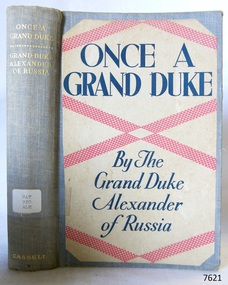
Book, Once A Grand Duke
This item is from the ‘Pattison Collection’, a collection of books and records that was originally owned by the Warrnambool Mechanics’ Institute, which was founded in Warrnambool in 1853. By 1886 the Warrnambool Mechanics’ Institute (WMI) had grown to have a Library, Museum and Fine Arts Gallery, with a collection of “… choice productions of art, and valuable specimens in almost every branch and many wonderful national curiosities are now to be seen there, including historic relics of the town and district.” It later included a School of Design. Although it was very well patronised, the lack of financial support led the WMI in 1911 to ask the City Council to take it over. In 1935 Ralph Pattison was appointed as City Librarian to establish and organise the Warrnambool Library as it was then called. When the WMI building was pulled down in 1963 a new civic building was erected on the site and the new Warrnambool Library, on behalf of the City Council, took over all the holdings of the WMI. At this time some of the items were separated and identified as the ‘Pattison Collection’, named after Ralph Pattison. Eventually the components of the WMI were distributed from the Warrnambool Library to various places, including the Art Gallery, Historical Society and Flagstaff Hill. Later some were even distributed to other regional branches of Corangamite Regional Library and passed to and fro. It is difficult now to trace just where all of the items have ended up. The books at Flagstaff Hill Maritime Village generally display stamps and markings from Pattison as well as a variety of other institutions including the Mechanics’ Institute itself. RALPH ERIC PATTISON Ralph Eric Pattison was born in Rockhampton, Queensland, in 1891. He married Maude Swan from Warrnambool in 1920 and they set up home in Warrnambool. In 1935 Pattison accepted a position as City Librarian for the Warrnambool City Council. His huge challenge was to make a functional library within two rooms of the Mechanics’ Institute. He tirelessly cleaned, cleared and sorted a disarrayed collection of old books, jars of preserved specimens and other items reserved for exhibition in the city’s museum. He developed and updated the library with a wide variety of books for all tastes, including reference books for students; a difficult task to fulfil during the years following the Depression. He converted all of the lower area of the building into a library, reference room and reading room for members and the public. The books were sorted and stored using a cataloguing and card index system that he had developed himself. He also prepared the upper floor of the building and established the Art Gallery and later the Museum, a place to exhibit the many old relics that had been stored for years for this purpose. One of the treasures he found was a beautiful ancient clock, which he repaired, restored and enjoyed using in his office during the years of his service there. Ralph Pattison was described as “a meticulous gentleman whose punctuality, floorless courtesy and distinctive neat dress were hallmarks of his character, and ‘his’ clock controlled his daily routine, and his opening and closing of the library’s large heavy doors to the minute.” Pattison took leave during 1942 to 1945 to serve in the Royal Australian Navy, Volunteer Reserve as Lieutenant. A few years later he converted one of the Museum’s rooms into a Children’s Library, stocking it with suitable books for the younger generation. This was an instant success. In the 1950’s he had the honour of being appointed to the Victorian Library Board and received more inspiration from the monthly conferences in Melbourne. He was sadly retired in 1959 after over 23 years of service, due to the fact that he had gone over the working age of council officers. However he continued to take a very keen interest in the continual development of the Library until his death in 1969. WARRNAMBOOL PUBLIC LIBRARY The Warrnambool Mechanics’ Institute (WMI) was formed by a voluntary community group in 1863, within six years of Warrnambool’s beginnings, and its Reading Room opened in 1854. The WMI operated until 1963, at which time it was one of the oldest Mechanics’ Institutes in Victoria. Mechanics’ Institutes offered important services to the public including libraries, reading rooms and places to display and store collections of all sorts such as curiosities and local historical relics. In 1886 a Museum and Fine Arts Gallery were added to the WMI and by the beginning of the 20th century there was also a billiards room and a School of Art. By this time all Mechanics’ Institutes in country Victoria had museums attached. Over the years the Warrnambool Mechanics’ Institute Library was also known as the Warrnambool Public Library the Warrnambool Library and the Free Library. Early funding from the government was for the “Free Library”. The inscription in a book “Science of Man” was for the “Warrnambool Public Library”, donated by Joseph Archibald in 1899. Another inscription in the book “Catalogue of Plants Under Cultivation in the Melbourne Botanic Gardens 1 & 2, 1883” was presented to the “Warrnambool Library” and signed by the author W.R. Guilfoyle. In 1903 the Warrnambool Public Library decided to add a Juvenile Department to library and stock it with hundreds of books suitable for youth. In 1905 the Public Library committee decided to update the collection of books and added 100 new novels plus arrangements for the latest novels to be included as soon as they were available in Victoria. In July 1911 the Warrnambool Council took over the management of the Public Library, Art Gallery, Museum and Mechanics’ Institute and planned to double the size of the then-current building. In 1953, when Mr. R. Pattison was Public Librarian, the Warrnambool Public Library’s senior section 10,000 of the 13,000 books were fiction. The children’s section offered an additional 3,400 books. The library had the equivalent of one book per head of population and served around 33 percent of the reading population. The collection of books was made up of around 60 percent reference and 40 percent fiction. The library was lending 400 books per day. In 1963 the Warrnambool City Council allocated the site of the Mechanics’ Institute building, which included the Public Library, Museum and Art Gallery, for the new Municipal Offices and the Collections were dispersed until 1971. The Warrnambool Library took over the Mechanics’ Institute Library’s holdings on behalf of the Warrnambool City Council. Since the closure of the Warrnambool Mechanics’ Institute the exact location and composition of the original WMI books and items has become unclear. Other materials have been added to the collection, including items from Terang MI, Warrnambool Court House and Customs House. Many of the books have been identified as the Pattison Collection, named after the Librarian who catalogued and numbered the books during his time as Warrnambool Public Librarian in the time before the Mechanics’ Institute closed. It seems that when Warrnambool became part of the Corangamite Regional Library some of the books and materials went to its head office in Colac and then back to Warrnambool where they were stored at the Art Gallery for quite some time. Some then went to the Warrnambool Historical Society, some stayed at the Art Gallery and some were moved to Flagstaff Hill Maritime Village. The various stamps and labels on the books held at Flagstaff Hill show the variety of the collection’s distribution and origin. The books in the collection at Flagstaff Hill Maritime Village date from the 1850’s to the late 1950’s and include rare and valuable volumes. Many of the books are part of the “Pattison Collection” after the Warrnambool’s Public Librarian, Mr. R. Pattison. The Pattison Collection, along with other items at Flagstaff Hill Maritime Village, was originally part of the Warrnambool Mechanics' Institute’s collection. The Warrnambool Mechanics’ Institute Collection is primarily significant in its totality, rather than for the individual objects it contains. Its contents are highly representative of the development of Mechanics' Institute libraries across Australia, particularly Victoria. A diversity of publications and themes has been amassed, and these provide clues to our understanding of the nature of and changes in the reading habits of Victorians from the 1850s to the middle of the 20th century. The collection also highlights the Warrnambool community’s commitment to the Mechanics’ Institute, reading, literacy and learning in the regions, and proves that access to knowledge was not impeded by distance. These items help to provide a more complete picture of our community’s ideals and aspirations. The Warrnambool Mechanics Institute book collection has historical and social significance for its strong association with the Mechanics Institute movement and the important role it played in the intellectual, cultural and social development of people throughout the latter part of the nineteenth century and the early twentieth century. The collection of books is a rare example of an early lending library and its significance is enhanced by the survival of an original collection of many volumes. The Warrnambool Mechanics' Institute’s publication collection is of both local and state significance. The Warrnambool Mechanics' Institute Collection is primarily significant in its totality, rather than for the individual objects it contains. Its contents are highly representative of the development of Mechanics' Institute libraries across Australia, particularly Victoria. A diversity of publications and themes has been amassed, and these provide clues to our understanding of the nature of and changes in the reading habits of Victorians from the 1850s to the middle of the 20th century. The collection also highlights the Warrnambool community’s commitment to the Mechanics’ Institute, and to reading, literacy and learning in the regions, and proves that access to knowledge was not impeded by distance. These items help to provide a more complete picture of our community’s ideals and aspirations. As with many Mechanics' Institutes in Australia, the one which operated in Warrnambool was established and overseen for many years by key individuals associated with the development of the city itself. The WMI publication collection is historically significant because of its association with local people, places and the key historical themes in the development of Warrnambool of rural development, industry, farming, education, and community. The collection documents and illustrates the changing interests, focus and tastes of Victorians, especially those in regional cities. Generally the individual items in the collection are not particularly rare, as examples of all probably exist in other public collections in Victoria. It is primarily because there are so very few surviving Mechanics' Institute collections in Victoria, which lends this overall collection its significance. Many items in the WMI Collection have the potential to support further research, both as individual objects and through the collection in its entirety. This material is significant for its ability to assist in the interpretation of the history of the area and adds to the general understanding of the development of the township. Many components of the WMI publication collection complement and reinforce the Flagstaff Hill Maritime Museum Collection, the Warrnambool Art Gallery Collection, and that in the Warrnambool Historical Society, and also contribute to a clearer understanding of the original Warrnambool Mechanics' Institute collections. This will greatly enhance the appreciation of the few surviving Mechanics' Institute collections across Victoria, and also in New South Wales. The similarities and differences between the small number of collections that have survived can provide further insights into how the people of Victoria in general, and Warrnambool in particular, constructed a civic culture of adult learning to foster an informed citizenry. The Warrnambool Mechanics' Institute publication collection is of both local and state significance. (This Statement of Significance is quoted from the Significance Assessment : Warrnambool Mechanics’ Institute Book Collection at Flagstaff Hill Maritime Museum, February 2009, by Annette Welkamp, Cultural Connections, for Delise Oldfied, FHMV) References Juvenile Department in Warrnambool Public Library In August 1903 The Age newspaper reported in its Warrnambool news section that “With the object of discouraging boys from reading literature of the “penny dreadful” class, the committee of the local public library has decided to open a juvenile department and to stock it with hundreds of suitable books attractive to the youthful mind.” 100 new novels added to Warrnambool Public Library Shelves In November 1905 The Argue newspaper’s Warrnambool news section announced “The committee of the Public Library is bringing the collection of books more up to date. It has recently added 100 new novels to the shelves, and arrangements have been made for a supply of the latest novels immediately they arrive in the state.” Warrnambool Town Council takes over Mechanics’ Institute, Art Gallery, Public Library, Museum – and will double the building’s size In 1912 The Age reported in its Warrnambool news section “Considerable improvements are being effected by the town council in the most picturesque part of Liebig Street. Between the fire brigade station and the mechanics’ institute and art gallery a vacant block of land is being transformed a garden for carpet bedding and flowering plants. The council, which recently took over the control of the art gallery, public library, museum and mechanics’ institute, is doubling the size of the substantial stone building containing these institutions. The new building will contain a supper room for use in conjunction with functions in the town hall, adjoining, and a new reading room.” Mr Pattison, Public Librarian, says Library has a book per head of population In 1953 The Age reported an interview with the Public Librarian, Mr. R. Pattison, who said “Warrnambool has an insatiable thirst for reading. And its reading recipe contains a strong dash of fiction – 73 percent of it. Fiction makes up 10,000 of the 13,000 books in the senior section of the public library. That works out at a book per head of population. Warrnambool today is really book minded. This city has an almost insatiable thirst for knowledge as well as fiction. We’re lending 400 books a day. We supply 33 percent of the reading population of Warrnambool.” The reporter goes on to say “Warrnambool Public Library also has an ultra-modern children’s section of 3,400 books, open to every boy and girl attending school in Warrnambool. Mr Pattison hopes to show travel-talk films and install a radiogram in the children’s section “later on”. But it won’t disturb adult reading next door because the junior section is sound proof. “ Mechanics’ Institutes and Museums Mechanics’ Institutes were important sites for collecting in country Victoria … Warrnambool … all had museums attached to Mechanics’ Institutes before the end of the twentieth century” Warrnambool Mechanics’ Institute Ms Tierney said FHMV holds the collection of the Warrnambool Mechanics’ Institute in three different locations on its site. “The Mechanics’ Institute opened in 1871, was demolished in the 1960s and was one of the oldest in Victoria. “FHMV intends to create a new storage area and bring the collection together in one place which will greatly facilitate access and research. “The collection consists of books and archives dating from the 1850s to 1959s. “Some of the books are rare and valuable but it is unclear as to their relevance to the history of Warrnambool or Victoria,” Ms Tierney said. Warrnambool TAFE History South West TAFE has a long and proud history of providing technical and specialist education, with links back to the formation of the Mechanic’s Institute in 1853. Warrnambool Art Gallery’s History The Warrnambool Art Gallery began in 1886 when retired police officer Joseph Archibald opened its doors in a building behind the mechanics institute in Liebig Street. The Gallery began with an eclectic mix of artworks and museum curios. Before long Archibald mobilised public support and paid for a new gallery annex. Loans and grants allowed the Gallery collection to grow with significant early acquisitions by French, German, and Belgian artists, which were less expensive than British works. Despite its enthusiastic start the economic downturn of the 1890s brought the Collection to a halt. In 1910 the Council took control of the Mechanics Institute and ran the Gallery there until 1963 when the building was allocated for municipal offices. The Collection was dispersed on loan to galleries in Shepparton and Hamilton and not reunited until 1971. In 1986 the Gallery’s Centenary year, a permanent home was built next to the ‘Civic Green’ and named in memory of one its champions Sir Fletcher Jones O.B.E. 2016 Warrnibald Entries Joseph Archibald established the Warrnambool Museum and Art Gallery in 1886 while his son Jules Francois Archibald founded the Archibald Prize through his bequest of 1919. His aim was to foster portraiture, as well as support artists, and perpetuate the memory of great Australians. Once A Grand Duke Author: Grand Duke Alexander of Russia Publisher: Cassell & Co Date: 1932Label on spine cover with typed text PAT 920 ALE Pastedown front endpaper has sticker from Warrnambool Public Library coverec by a sticker from Corangamite Regional Library Service warrnambool, shipwrecked-coast, flagstaff-hill, flagstaff-hill-maritime-museum, maritime-museum, shipwreck-coast, flagstaff-hill-maritime-village, shipwrecked-artefact, book, pattison collection, warrnambool library, warrnambool mechanics’ institute, ralph eric pattison, corangamite regional library service, warrnambool city librarian, mechanics’ institute library, victorian library board, warrnambool books and records, warrnambool children’s library, great ocean road, once a grand duke, grand duke alexander of russia -
 Flagstaff Hill Maritime Museum and Village
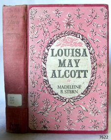
Book, Louisa May Alcott
This item is from the ‘Pattison Collection’, a collection of books and records that was originally owned by the Warrnambool Mechanics’ Institute, which was founded in Warrnambool in 1853. By 1886 the Warrnambool Mechanics’ Institute (WMI) had grown to have a Library, Museum and Fine Arts Gallery, with a collection of “… choice productions of art, and valuable specimens in almost every branch and many wonderful national curiosities are now to be seen there, including historic relics of the town and district.” It later included a School of Design. Although it was very well patronised, the lack of financial support led the WMI in 1911 to ask the City Council to take it over. In 1935 Ralph Pattison was appointed as City Librarian to establish and organise the Warrnambool Library as it was then called. When the WMI building was pulled down in 1963 a new civic building was erected on the site and the new Warrnambool Library, on behalf of the City Council, took over all the holdings of the WMI. At this time some of the items were separated and identified as the ‘Pattison Collection’, named after Ralph Pattison. Eventually the components of the WMI were distributed from the Warrnambool Library to various places, including the Art Gallery, Historical Society and Flagstaff Hill. Later some were even distributed to other regional branches of Corangamite Regional Library and passed to and fro. It is difficult now to trace just where all of the items have ended up. The books at Flagstaff Hill Maritime Village generally display stamps and markings from Pattison as well as a variety of other institutions including the Mechanics’ Institute itself. RALPH ERIC PATTISON Ralph Eric Pattison was born in Rockhampton, Queensland, in 1891. He married Maude Swan from Warrnambool in 1920 and they set up home in Warrnambool. In 1935 Pattison accepted a position as City Librarian for the Warrnambool City Council. His huge challenge was to make a functional library within two rooms of the Mechanics’ Institute. He tirelessly cleaned, cleared and sorted a disarrayed collection of old books, jars of preserved specimens and other items reserved for exhibition in the city’s museum. He developed and updated the library with a wide variety of books for all tastes, including reference books for students; a difficult task to fulfil during the years following the Depression. He converted all of the lower area of the building into a library, reference room and reading room for members and the public. The books were sorted and stored using a cataloguing and card index system that he had developed himself. He also prepared the upper floor of the building and established the Art Gallery and later the Museum, a place to exhibit the many old relics that had been stored for years for this purpose. One of the treasures he found was a beautiful ancient clock, which he repaired, restored and enjoyed using in his office during the years of his service there. Ralph Pattison was described as “a meticulous gentleman whose punctuality, floorless courtesy and distinctive neat dress were hallmarks of his character, and ‘his’ clock controlled his daily routine, and his opening and closing of the library’s large heavy doors to the minute.” Pattison took leave during 1942 to 1945 to serve in the Royal Australian Navy, Volunteer Reserve as Lieutenant. A few years later he converted one of the Museum’s rooms into a Children’s Library, stocking it with suitable books for the younger generation. This was an instant success. In the 1950’s he had the honour of being appointed to the Victorian Library Board and received more inspiration from the monthly conferences in Melbourne. He was sadly retired in 1959 after over 23 years of service, due to the fact that he had gone over the working age of council officers. However he continued to take a very keen interest in the continual development of the Library until his death in 1969. WARRNAMBOOL PUBLIC LIBRARY The Warrnambool Mechanics’ Institute (WMI) was formed by a voluntary community group in 1863, within six years of Warrnambool’s beginnings, and its Reading Room opened in 1854. The WMI operated until 1963, at which time it was one of the oldest Mechanics’ Institutes in Victoria. Mechanics’ Institutes offered important services to the public including libraries, reading rooms and places to display and store collections of all sorts such as curiosities and local historical relics. In 1886 a Museum and Fine Arts Gallery were added to the WMI and by the beginning of the 20th century there was also a billiards room and a School of Art. By this time all Mechanics’ Institutes in country Victoria had museums attached. Over the years the Warrnambool Mechanics’ Institute Library was also known as the Warrnambool Public Library the Warrnambool Library and the Free Library. Early funding from the government was for the “Free Library”. The inscription in a book “Science of Man” was for the “Warrnambool Public Library”, donated by Joseph Archibald in 1899. Another inscription in the book “Catalogue of Plants Under Cultivation in the Melbourne Botanic Gardens 1 & 2, 1883” was presented to the “Warrnambool Library” and signed by the author W.R. Guilfoyle. In 1903 the Warrnambool Public Library decided to add a Juvenile Department to library and stock it with hundreds of books suitable for youth. In 1905 the Public Library committee decided to update the collection of books and added 100 new novels plus arrangements for the latest novels to be included as soon as they were available in Victoria. In July 1911 the Warrnambool Council took over the management of the Public Library, Art Gallery, Museum and Mechanics’ Institute and planned to double the size of the then-current building. In 1953, when Mr. R. Pattison was Public Librarian, the Warrnambool Public Library’s senior section 10,000 of the 13,000 books were fiction. The children’s section offered an additional 3,400 books. The library had the equivalent of one book per head of population and served around 33 percent of the reading population. The collection of books was made up of around 60 percent reference and 40 percent fiction. The library was lending 400 books per day. In 1963 the Warrnambool City Council allocated the site of the Mechanics’ Institute building, which included the Public Library, Museum and Art Gallery, for the new Municipal Offices and the Collections were dispersed until 1971. The Warrnambool Library took over the Mechanics’ Institute Library’s holdings on behalf of the Warrnambool City Council. Since the closure of the Warrnambool Mechanics’ Institute the exact location and composition of the original WMI books and items has become unclear. Other materials have been added to the collection, including items from Terang MI, Warrnambool Court House and Customs House. Many of the books have been identified as the Pattison Collection, named after the Librarian who catalogued and numbered the books during his time as Warrnambool Public Librarian in the time before the Mechanics’ Institute closed. It seems that when Warrnambool became part of the Corangamite Regional Library some of the books and materials went to its head office in Colac and then back to Warrnambool where they were stored at the Art Gallery for quite some time. Some then went to the Warrnambool Historical Society, some stayed at the Art Gallery and some were moved to Flagstaff Hill Maritime Village. The various stamps and labels on the books held at Flagstaff Hill show the variety of the collection’s distribution and origin. The books in the collection at Flagstaff Hill Maritime Village date from the 1850’s to the late 1950’s and include rare and valuable volumes. Many of the books are part of the “Pattison Collection” after the Warrnambool’s Public Librarian, Mr. R. Pattison. The Pattison Collection, along with other items at Flagstaff Hill Maritime Village, was originally part of the Warrnambool Mechanics' Institute’s collection. The Warrnambool Mechanics’ Institute Collection is primarily significant in its totality, rather than for the individual objects it contains. Its contents are highly representative of the development of Mechanics' Institute libraries across Australia, particularly Victoria. A diversity of publications and themes has been amassed, and these provide clues to our understanding of the nature of and changes in the reading habits of Victorians from the 1850s to the middle of the 20th century. The collection also highlights the Warrnambool community’s commitment to the Mechanics’ Institute, reading, literacy and learning in the regions, and proves that access to knowledge was not impeded by distance. These items help to provide a more complete picture of our community’s ideals and aspirations. The Warrnambool Mechanics Institute book collection has historical and social significance for its strong association with the Mechanics Institute movement and the important role it played in the intellectual, cultural and social development of people throughout the latter part of the nineteenth century and the early twentieth century. The collection of books is a rare example of an early lending library and its significance is enhanced by the survival of an original collection of many volumes. The Warrnambool Mechanics' Institute’s publication collection is of both local and state significance. The Warrnambool Mechanics' Institute Collection is primarily significant in its totality, rather than for the individual objects it contains. Its contents are highly representative of the development of Mechanics' Institute libraries across Australia, particularly Victoria. A diversity of publications and themes has been amassed, and these provide clues to our understanding of the nature of and changes in the reading habits of Victorians from the 1850s to the middle of the 20th century. The collection also highlights the Warrnambool community’s commitment to the Mechanics’ Institute, and to reading, literacy and learning in the regions, and proves that access to knowledge was not impeded by distance. These items help to provide a more complete picture of our community’s ideals and aspirations. As with many Mechanics' Institutes in Australia, the one which operated in Warrnambool was established and overseen for many years by key individuals associated with the development of the city itself. The WMI publication collection is historically significant because of its association with local people, places and the key historical themes in the development of Warrnambool of rural development, industry, farming, education, and community. The collection documents and illustrates the changing interests, focus and tastes of Victorians, especially those in regional cities. Generally the individual items in the collection are not particularly rare, as examples of all probably exist in other public collections in Victoria. It is primarily because there are so very few surviving Mechanics' Institute collections in Victoria, which lends this overall collection its significance. Many items in the WMI Collection have the potential to support further research, both as individual objects and through the collection in its entirety. This material is significant for its ability to assist in the interpretation of the history of the area and adds to the general understanding of the development of the township. Many components of the WMI publication collection complement and reinforce the Flagstaff Hill Maritime Museum Collection, the Warrnambool Art Gallery Collection, and that in the Warrnambool Historical Society, and also contribute to a clearer understanding of the original Warrnambool Mechanics' Institute collections. This will greatly enhance the appreciation of the few surviving Mechanics' Institute collections across Victoria, and also in New South Wales. The similarities and differences between the small number of collections that have survived can provide further insights into how the people of Victoria in general, and Warrnambool in particular, constructed a civic culture of adult learning to foster an informed citizenry. The Warrnambool Mechanics' Institute publication collection is of both local and state significance. (This Statement of Significance is quoted from the Significance Assessment : Warrnambool Mechanics’ Institute Book Collection at Flagstaff Hill Maritime Museum, February 2009, by Annette Welkamp, Cultural Connections, for Delise Oldfied, FHMV) References Juvenile Department in Warrnambool Public Library In August 1903 The Age newspaper reported in its Warrnambool news section that “With the object of discouraging boys from reading literature of the “penny dreadful” class, the committee of the local public library has decided to open a juvenile department and to stock it with hundreds of suitable books attractive to the youthful mind.” 100 new novels added to Warrnambool Public Library Shelves In November 1905 The Argue newspaper’s Warrnambool news section announced “The committee of the Public Library is bringing the collection of books more up to date. It has recently added 100 new novels to the shelves, and arrangements have been made for a supply of the latest novels immediately they arrive in the state.” Warrnambool Town Council takes over Mechanics’ Institute, Art Gallery, Public Library, Museum – and will double the building’s size In 1912 The Age reported in its Warrnambool news section “Considerable improvements are being effected by the town council in the most picturesque part of Liebig Street. Between the fire brigade station and the mechanics’ institute and art gallery a vacant block of land is being transformed a garden for carpet bedding and flowering plants. The council, which recently took over the control of the art gallery, public library, museum and mechanics’ institute, is doubling the size of the substantial stone building containing these institutions. The new building will contain a supper room for use in conjunction with functions in the town hall, adjoining, and a new reading room.” Mr Pattison, Public Librarian, says Library has a book per head of population In 1953 The Age reported an interview with the Public Librarian, Mr. R. Pattison, who said “Warrnambool has an insatiable thirst for reading. And its reading recipe contains a strong dash of fiction – 73 percent of it. Fiction makes up 10,000 of the 13,000 books in the senior section of the public library. That works out at a book per head of population. Warrnambool today is really book minded. This city has an almost insatiable thirst for knowledge as well as fiction. We’re lending 400 books a day. We supply 33 percent of the reading population of Warrnambool.” The reporter goes on to say “Warrnambool Public Library also has an ultra-modern children’s section of 3,400 books, open to every boy and girl attending school in Warrnambool. Mr Pattison hopes to show travel-talk films and install a radiogram in the children’s section “later on”. But it won’t disturb adult reading next door because the junior section is sound proof. “ Mechanics’ Institutes and Museums Mechanics’ Institutes were important sites for collecting in country Victoria … Warrnambool … all had museums attached to Mechanics’ Institutes before the end of the twentieth century” Warrnambool Mechanics’ Institute Ms Tierney said FHMV holds the collection of the Warrnambool Mechanics’ Institute in three different locations on its site. “The Mechanics’ Institute opened in 1871, was demolished in the 1960s and was one of the oldest in Victoria. “FHMV intends to create a new storage area and bring the collection together in one place which will greatly facilitate access and research. “The collection consists of books and archives dating from the 1850s to 1959s. “Some of the books are rare and valuable but it is unclear as to their relevance to the history of Warrnambool or Victoria,” Ms Tierney said. Warrnambool TAFE History South West TAFE has a long and proud history of providing technical and specialist education, with links back to the formation of the Mechanic’s Institute in 1853. Warrnambool Art Gallery’s History The Warrnambool Art Gallery began in 1886 when retired police officer Joseph Archibald opened its doors in a building behind the mechanics institute in Liebig Street. The Gallery began with an eclectic mix of artworks and museum curios. Before long Archibald mobilised public support and paid for a new gallery annex. Loans and grants allowed the Gallery collection to grow with significant early acquisitions by French, German, and Belgian artists, which were less expensive than British works. Despite its enthusiastic start the economic downturn of the 1890s brought the Collection to a halt. In 1910 the Council took control of the Mechanics Institute and ran the Gallery there until 1963 when the building was allocated for municipal offices. The Collection was dispersed on loan to galleries in Shepparton and Hamilton and not reunited until 1971. In 1986 the Gallery’s Centenary year, a permanent home was built next to the ‘Civic Green’ and named in memory of one its champions Sir Fletcher Jones O.B.E. 2016 Warrnibald Entries Joseph Archibald established the Warrnambool Museum and Art Gallery in 1886 while his son Jules Francois Archibald founded the Archibald Prize through his bequest of 1919. His aim was to foster portraiture, as well as support artists, and perpetuate the memory of great Australians. Louisa May Alcott Author: Madeleine B Stern Publisher: Peter Nevill Date: 1952Label on spine cover with typed text PAT 920 ALC Pastedown front endpaper has sticker from Warrnambool Mechanics Institute and Free Library covered by a sticker from Corangamite Regional Library Service Front endpaper has a small sticker that reads " F. W. Cheshire Pty. Ltd., 338 Little Collins Street, Melbourne."warrnambool, shipwrecked-coast, flagstaff-hill, flagstaff-hill-maritime-museum, maritime-museum, shipwreck-coast, flagstaff-hill-maritime-village, shipwrecked-artefact, book, pattison collection, warrnambool library, warrnambool mechanics’ institute, ralph eric pattison, corangamite regional library service, warrnambool city librarian, mechanics’ institute library, victorian library board, warrnambool books and records, warrnambool children’s library, great ocean road, louisa may alcott, peter nevill -
 Mortlake and District Historical Society
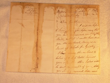
Letter for payment of account Mortlake Mill, March 7 1864
This letter was sent by a customer D. Menzies at Skipton to the Mortlake Mill, detailing an unusual payment method for the processing of his wheat into flour. David Menzies was a Scots farmer who lived in Skipton c. 1860's on a bend in the Mount Emu Creek. He helped establish the local school and a lane in the township bears his name. The letter illustrates the nature of commerce and the difficulties of communication and life generally in the country at the time. The bluestone Mortlake Mill built in 1856, has been a prominent landmark in Mortlake for over 150 years. It played a significant role in the commercial life of the town and was initially a wind-mill to process district grain for sale. The goldrush at Ararat 100 km. away led to a temporarily increased population and demand for foodstuffs. In 1857 the Mill was sold to Aikman, Hamilton and Geddes who converted it to steampower and later built the prominent chimney, which is on the Heritage Register as part of the National Estate. D. Menzies at Skipton lived at least 85 km away - his wheat which urgently needed milling, faced a slow and arduous journey by bullock dray. After the demise of the Ararat goldfields and the decline in population (as well as the district soils proving unsuitable for sustained wheat cultivation), the operation of the Mill declined too and the proprietors increased their involvement in other activities - supply of building materials, timber felling and sawmills. Despite the apparent difficulties of conducting business in the 1850's, it is notable that commerce thrived at that time in country districts, as an examination of Mill accounts and records show.Handwritten letter dated 1864 (water-stained)Skipton March 7 1864 [to] Messrs. Hamilton & Co. Mortlake. Dear Gentlemen, I was in hope of hearing from you before now that you had commenced working the Mill, & that I could have sent you the enclosed money [for a] load of wheat for Gristing. Please receive the enclosed 2 halves of 2 [two] 5 [pound sign] notes forwarded to your account. the other halves will be sent on receipt of your stating you having received those notes sent. As I am out of flour be so good as say how soon I may send a load of wheat. In haste I am Gentlemen Yours truly D. Menziesmortlake mill grain wheat hamilton geddes aikman laang dixie menzies skipton -
 Greensborough Historical Society
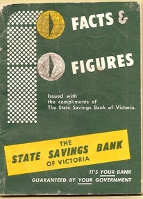
Book, Facts & Figures, 1967_06
This 64 page booklet was first issued in 1958 and distributed free of charge to customers. It contained such interesting snippets as a list of Kings and Queens of England to population lists and information about the planets. This was a popular item amongst school children.The State Savings Bank of Victoria existed until 1991 when it was taken over by the Commonwealth Bank of Australia. It was a major provider of home loan in the post war period.A 62 page booklet issued by the State Savings Bank of Victoria. The outer cover has a dark olive green background colour and has some yellow detail in the design.Some pencil scribbling on inside covers.state savings bank of victoria, ssb -
 Glenelg Shire Council Cultural Collection
Programme - Programme - Wallacedale Racing Club Picnic, 1914, Hamilton Spectator, Apr-14
Formerly from the Bower Bird Museum collection in Heywood. Wallacedale is in western Victorian 28km sw of Hamilton. It was created by draining the Condah Swamp. After WWII the population declined and in the 1970s the school closed.Four page cardboard programme for the Wallacedale Racing Club's Picnic Meeting on April 18, 1914. Printing in black. Pages held together with sellotape.wallacedale, condah, condah swamp -
 Kiewa Valley Historical Society
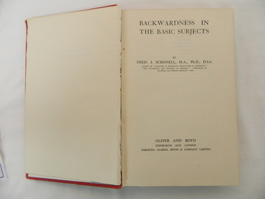
Book - Reference Remedial Education, "Backwardness in the Basic Subjects", 1942 First Edition, reprinted 1952
This publication was produced in the mid 1900s when the study of learning disabilities in children was in its infancy stage. The complexities of teaching methodologies to cover various symptoms uncovered by pre-school and primary school education facilities was that "one method suites all". This format changed in the later 1900s when specific "tailor made" teaching facilities where introduced and the "average" pre-school and primary school teaching professionals where not "on the whole" faced with the requirement to apply special remedial programs themselves but instead instigated a referral to dedicated specialists. This book covers the rural student with slow reading, comprehension and writing problems, in an environment where specialist speech therapists and child psychologists were and are still rare.This book although very thorough and highlights the major "communication and reading symptoms, in school children" and remedial treatment, places undue pressure upon those teachers, who, at some rural schools are faced with teaching classroom of students varying in age and thereby abilities of comprehension. Schools in rural Australia sometimes had smaller numbers of classrooms and facilities due to their small feeder population and their regional isolation. The Kiewa Valley before the dramatic increase in population in the mid 1950s (SEC Hydro Scheme) was one of these rural communities whose "schooling population" was diverse and small. This reference book, which was used at a Kiewa Valley primary school, reflects upon the Department of Education in Victoria as a highly professional organisation readily applying "modern" learning techniques to all of the department's regional areas. By this broad based application, no school was seen as having any disadvantage due to physical and/or financial isolation.This book has a plain red, cloth bonded, hard cardboard cover with an envelope attached to the inside back cover. The book has a one front blank flyleaf and two rear flyleaves. All lettering ,diagrams, sketches are in black on white as is the only photograph.There is three double sided "preface" pages and nine "contents" pages. There are 508 double sided pages covering 20 chapters and 25 double sided Appendices (5) and four double sided "Index Of Subjects". The cover has printing only on the spine.On the spine at the top "BACKWARDNESS IN THE BASIC SUBJECTS" underneath "SCHONELL" and at the bottom "OLIVER & BOYD"teacher reference books, remedial programs for disadvantages school children, special needs education programs, teacher training -
 Kiewa Valley Historical Society
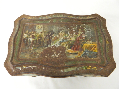
Tin Biscuit/Tea, Early to mid 1900s
This biscuit/tea caddy was probably targeting the "theatre going" family or those who liked looking at the colourful shakespearian scenes. This item however demonstrates that the rural (Kiewa Valley) appreciation of classic English plays was, in this time period (early 1900's), just as strong as in the larger towns and cities. This item also presents the period in which the "olde" Elizabethian phrases and words were taught in regional high schools. Although this speech pattern and phraseology was of a specific time period and going out of fashion when Australia was first settled it was an inherited form of communication(higher social/economical level). In the context of the rural Australia "scene" and in this time frame of the elite "boarding school" generation this item was a visual reinforcement of the education level and position of the family who owned this tin.This item is highly significant because it not only presents the social aspects of early life in the Kiewa Valley but also the variety of educational levels and economical variations of the rural population within the Kiewa Valley. The egalitarian perception of the inhabitants of the Kiewa Valley was still at the infancy of early Australian social interactions. This biscuit /tea container was however a leveling of the socio-economic playing field of the time.This biscuit or tea tin, has besides having an outer lid (hinged), it also has an internal lid(with a circular finger grip). Although the shape is rectangular it has a slight concave bulge at each side of the centre of each of its main frame. It is made of pressed light steel and has a raised floor. The corners are bevelled and the outer lid has a bevelled slope ridge in parallel to the extremities of the main tin frame. There are painted scenes from the following Shakespearian plays on each side of the tin; "As you like it", "Hamlet" and on each of the bevelled corners are the portraits of Shakespeare(in the middle), the caricature mask faces of "the theatre" above and on the bottom section the "Director's chair"food storage, kitchen table container, domestic educational storage, shakespeare illustrations -
 Kiewa Valley Historical Society
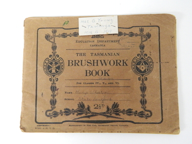
Book - Sketch Book, Circa 1918
This childhood sketchbook of the 1918 era details the emphasis placed upon a skill of brushwork that portrayed part of the students natural environment both in Tasmanian schools and Victorian schools, especially rural schools. The close bondage between students and their environment was a reflection on the early "hands on" approach in child education. Abstract art or teaching aids which could not be identified with physical properties available to students at this period in time were of lesser value. The ability of the student to identify the artistic value of local nature eg. local plants and flowers was especial important to rural based school children who had limited excursion opportunities available to visit town/city based botanical gardens and museums. This brushwork book is very significant to the Kiewa Valley as it demonstrates that childhood relocations from one State to another were not detrimental to the students overall scholastic development. The rural environment in Tasmania was not that far removed from the rural environment of the Kiewa Valley. The skills taught in both regions were still the same and the socio-economic factors and mores were also similar. This item demonstrates the relocation of one family from Tasmania to the Kiewa Valley. The expansion in population into the Kiewa valley was quite erratic and significant population growth only came after the increase in population brought into the area by the SEC Vic Hydro Scheme introduced to quench the demand for Victoria's electricity.This book has a brown cover with black print and designs on a 150 gsm cardboard. Each page is of the same thickness as the cover but is of paper.On the outside cover and contained within a thick boarder. "EDUCATION DEPARTMENT" and below this in smaller print "TASMANIA" below this "THE TASMANIAN BRUSHWORK BOOK". Below this "FOR CLASSES IV., V., AND VI" Below this "NAME" SCHOOL" At the bottom 2 1/2d1918's educational sketchbook, 1918 children's sketchbook -
 Eltham District Historical Society Inc
Photograph, St Andrews Primary School, Eltham Heritage Tour, 24 May 1992, 24/05/1992
ELTHAM HERITAGE TOUR The Society excursion on 24th May 1992 was arranged by David Bick, leader of the team carrying out the Shire's heritage study. David selected a number of sites or buildings identified in the study, some of them lesser known components of the Shire's heritage. The tour commenced at the Eltham Shire Office at 10.00 am. Travel was by private car and mini-bus with stops at about twelve locations for commentary by David.It included a short walk in Hurstbridge and lunch at Kinglake. Highlights of the tour included: - 10 am Leave from Shire Offices - 3 Important Trees - A Physical Link to Eltham's First Settlers - Toorak Mansion Gates - A Surviving Farm House - An Intact Circa 1900 Main Street - First Settlers - Gold Miners, and Timber-getters - An Early Hotel - A Pioneering Homestead - Changing Eltham Shire - 20th Century - 4 pm Afternoon Tea and Finish Tour Extract from ELTHAM CULTURAL HERITAGE TOUR (Newsletter No. 85, July 1992, by Bettina Woodburn) "At St Andrews we noted the old and new schools, the Anglican Church, the Hall, the Bakery and the pub – still a popular watering and eating place. Climbing towards Panton Hill the soil was not rich and supported only scarce growth. Perfunctory prospecting and mining had taken place in this area, though not with the diligence applied at Research. Again we saw the ingredients of a settlement, this one organised by Government, the Hotel, the Store, the School. Down from Memorial Park the School grounds had original tree planting and the School Bell dedicated to Maud Rattray who died in 1922. There is a new Hall and opposite in the grounds of the Church and Sunday School a modest Memorial Cross of granite with inscriptions and in memory of four 'fallen comrades'. This small section of the main road retained the small village atmosphere; although the population had increased there had been little alteration."Record of the Society's history and activities and highlighting various aspects of the Heritage Study undertaken by David Bick used to create the future heritage overlay for the Shire of Eltham and later Nillumbik Shire.Roll of 35mm colour negative film, 4 stripsKodak Gold 100 5095shire of eltham historical society, activities, heritage tour, st andrews -
 Kiewa Valley Historical Society
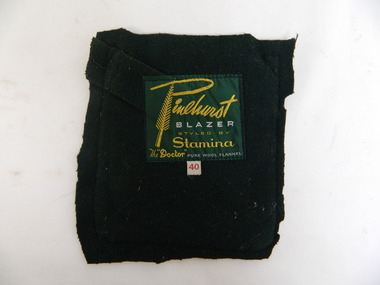
School Blazer Pocket Badge
Mt Beauty Higher Elementary School commenced in 1953 as the need for a secondary school grew with the increase in population due to the Kiewa Hydro Scheme. It became the Mt Beauty High School in 1964. The blazer was worn as part of the winter uniform.Historical: Education in Mt Beauty commenced relatively late so there was less of a tradition. The decision to adopt a uniform is of interest to compare with other schools and the times.Pure wool dark green flannel pocket cut out from a Mt Beauty High School blazer. Emblem is machine stitched and has a yellow wattle decoration outside a yellow frame. Across the top of the frame in yellow 'High School", across the bottom of the frame "Mount Beauty", the 2 sides of the frame are hollow. Inside the frame is a stitched picture with a light blue sky, royal blue mountains with white peaks and a white curved path leads towards the mountains with light green 'paddocks' either side. Inscription on back in yellow and white.Pinehurst / Blazer (in white) / Styled by Stamina / The "Doctor" / Pure Wool Flannel (in white) blazer, school, high school, uniform, mt beauty, emblem, education, clothing, winter -
 Kiewa Valley Historical Society
Papers - History of Schools in the Kiewa Valley
Education in the Kiewa Valley began with small schools in many locations enabling the children from the farms to attend their nearby school. As the number of children decreased and transport improved the schools were consolidated into fewer schools located in a centralised position.The history of each school gives an insight into the surrounding population - their numbers, occupations and lifestyle as well as their involvement in the running of the schools eg. Mothers' Clubs etc.8 groups of foolscap size papers stapled or pinned together each with the heading 'School History'. The first 4 are the same - "Mt Beauty School'. There is one for 'Mt Beauty High School', One for 'Mullindoligong School', One for 'Tawonga School'.One for 'Tawonga South School'.kiewa valley education, schools in the kiewa valley -
 Kiewa Valley Historical Society
Photos - Mt Beauty Schools
Mt Beauty HES school was created for the children of the employees of the State Electricity Commission of Victoria who were constructing the Kiewa Hydro Electric Scheme at the head of the Kiewa Valley at the new town of Mount Beauty. Mt Beauty School consisted of Mt Beauty Higher Elementary School 1948-1964 before it was split into the current (2023) Mt Beauty Primary School and Mt Beauty High School. See. "Kiewa Kids" by Graham Gardner pages 94-180. "Below Bogong-A History of Mount Beauty" compiled by Di Edmondson. chapter 7, Pages 178-230.As the population changed so did the schools in name, size etc. Also what started as a very modern school in the 1948 to what is now an older style wooden building2 larger photos 1 b & w - hurdles race and 1 colored 3 girls sitting in front of computers 9 medium size photos 1 b & w students and 1 of car; 1 of school building and 1 of student group; 5 coloured sports daymt beauty higher elementary school -
 Kiewa Valley Historical Society
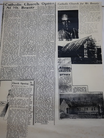
Booklets and Papers - St Joseph's Catholic Church Mt Beauty, St Joseph's Catholic Church Mt Beauty Golden Jubilee 1954-2004
Catholics from Tawonga attended Mass at Dederang the area being part of the Myrtleford parish. With the coming of the State Electricity Commission and the increase in population Masses were said in various schools, homes and halls between Tawonga and Mt Beauty until the completion of St Joseph's ChurchSt Joseph's Catholic Church, Mt Beauty was consecrated on November 7th 1954. The SEC allocated land to each of the churches for them to provide their own places of worship. It was built by volunteers who donated money and their time to raise funds and build the church.1. Booklet with yellow cover, black print and 28 pages back to back held by 2 staples. 2. Booklet "Mass to Celebrate the 40th Anniversary of St Joseph's Church Mt Beauty 1954-1994" 4 pages back to back 3. Papers: vary - 1. A3 sheet with articles from newspapers "Catholic Church Opens At Mt Beauty"; "Catholic Church for Mt. Beauty". 2. x4 A4 sheets typed back to back -"Recalling the first 40 years" 3. St Joseph's Mt Beauty 1968-69 Lawn Cutting Roster 4. Miscellanious st joseph's mt beauty, catholic church, golden jubilee, religion -
 Kiewa Valley Historical Society
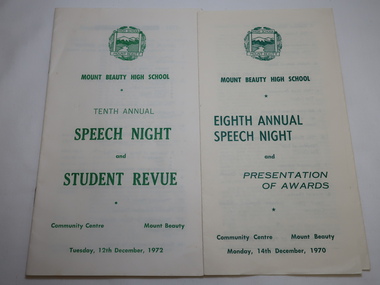
Mt Beauty High School Speech Night 1971 and 1972
Mount Beauty High School was proclaimed in 1963 with 213 pupils, 12 staff members. The enrolments and staff numbers increased as the Kiewa Hydro Electric Scheme continued to be constructed . 1. The Annual Report gives details re Accommodation, Grounds & Buildings, Equipment, Curriculum, Activities, Advisory Council, Cafeteria, Staff and Thanks. 2. In 1972, 27 teachers (names & subjects) are listed as well as other staff. The Reports are similar to that in 1970Mt Beauty High School grew quickly and then declined in numbers as the Kiewa Hydro Electric Scheme was constructed from the late 1940s to the 1960s. It is currently (2023) still operating serving the population in the Kiewa Valley. 1.Pale yellow paper folded x2 opening up to 3 columns of green print. 12 items listed followed by 'Extracts from the Eighth Annual Report. The Report contiues on the back. Front page has logo, title & date 14th Dec. 1970 2. Booklet of 12 pages (6 paper sheets)14 items on page 2, Staff listed on page 3, Principal's Report on page 4- 6. S.R.C. Report page 7, 10th Annual Report page 8-9,President's Report page 10. Scholarships & Awards page 11-12. Front page has logo and title. Tenth Annual Speech Night and Student Revue 12th December 1972 mt beauty high school, speech night programmes 1970 1972 -
 Kiewa Valley Historical Society
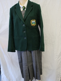
Uniform - Mt Beauty High School
Mt Beauty High School commenced in 1953 as a Higher Elementary school as the need for a secondary college grew with the increase in population due to the Kiewa Hydro Electric Scheme. It became the Mt Beauty High School in 1964.Historical: Education in Mt Beauty commenced relatively late so there was less of a tradition. The decision to adopt a uniform is of interest to compare it with other schools and the times.Girls winter school uniform consisting of - Blazer x4 See KVHS 0019 Dark green blazer made from pure wool flannel. It has 3 pockets - 2 lower ones on each side and on the left pocket at chest height is the cloth badge 'Mt Beauty' at the top, colored scene of mountains and river in the middle and 'High School' at the bottom.... Shirt - x2 White long sleeved blouse with collar, buttons down the front and one button on each sleeve. Tie - 124 cm long with pointy ends and with a diagonal yellow stripe 0.5 cm wide on green 2.5 cm apart. Label: "Tee Dee" Made in Australia 90% wool 10% nylon Tunic - Grey pleated tunic (3 pleats on both the front and back) with a zip pocket on the right from the waist 14 cm long Also a 3.5 cm wide grey belt with grey plastic buckle and Label on centre back at neck: "Stamina / clothes/ Tailored by / Expert Craftsmen / Crusador Cloth" Size 46 uniform, mt beauty high school, school uniform -
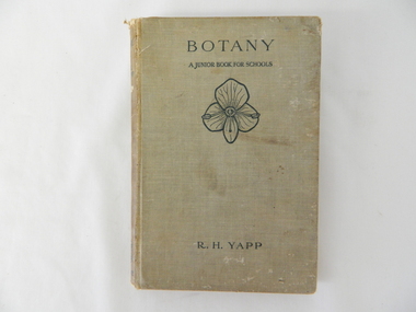 Kiewa Valley Historical Society
Book - Reference Botany, Botany - A Junior Book For Schools, 1927
This book was a highly regarded reference book for students in primary and lower secondary schools within Victoria from the late 1800s to the mid 1900s. The book provided students with the fundamental knowledge of botany for the era in which it was produced. As this book was targeting a junior schooling level (basic), it could cover a greater and extended reader population. Teaching institutions could, because of its straight forward, basic written information, retain this book's circulation for a greater length of time, thereby optimising the return against the greater initial costs of importing it from England.This book was produced in a time where learning was at a relatively slower pace (due to a smaller source and supply of material). The availability of a large range of cheap reference books such as that offered from 1971 on wards via the internet "Project Guttenberg" in the form of electronic books, has dramatically provided a larger source of reference material. The significance of this book on botany, is that it was highly effective for the era in which it was produced and in particular the students at a rural based school. Being in a rural area students were able to identify local vegetation to the various life cycles of plants presented in this mainly United Kingdom/European referenced book. The students in the Kiewa Valley and attending a rural school, where in a position to study all the fundamental teaching that this book encompassed. This in one way provided students in the valley a slightly better appreciation between book and real life (on the land, in the field and by the river). Later publications of this book had additional Australian references in them.This hard covered book(cloth strengthened) is faded(aged) beige in colour and consists of 204 pages. It is printed in English (black print) on both sides and contains illustrations of both free hand sketches and photographs of plants, both foliage and roots systems. The book is arranged in three sections: three pages of preface, two of contents (28 chapters). The last four pages contain the appendix and index.On spine "BOTANY" underneath "R.H. YAPP" and at bottom the Cambridge coat of Arms and below this "CAMBRIDGE" The front cover "BOTANY" underneath this "A JUNIOR BOOK FOR SCHOOLS" and below this a an illustration of a four leaf petal(flower of Germander Speedwell) the same as appears on the cover of edition 2, however this book is edition 3. At the bottom is "R.H. YAPPschool, botany, text books, science experiments, nature -
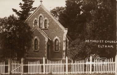 Eltham District Historical Society Inc
Photograph, Eltham Methodist Church, 1909, 1909
Situated at 810 Main Road on the corner of John Street. The Church was surrounded by a picket fence and tall pine trees. The Church was built by George Stebbings in the 1850s and is an example of fine craftmanship. Formerly Wesleyan, Methodist then Uniting church; the foundations of the church building were constructed with stone from the walls of the first Eltham State Primary School (No. 209) building which collapsed in 1874 and were purchased by Robert David Taylor. REVISED STATEMENT OF SIGNIFICANCE, CONTEXT, 2010 via Victorian Heritage Database What is significant? The 1880 bichromatic brick church and the surrounding site to the title boundaries. How is it significant? The church is architecturally, historically, socially and spiritually significant to the Shire of Nillumbik. Why is it significant? The church is architecturally significant as a finely detailed example of a brick 19th century rural community church, one of only four in the Shire (Criteria E & B). The church is historically significant as an important link with the time when Eltham was a small, insular country settlement. Also for the historical evolution visible in the complex, with the modest 1880s church and larger red brick rear hall from the early 20th century as a reflection of population growth in the area (Criterion A). The church is historically, spiritually and socially significant because it has played, and continues to play, an important part in the spiritual and social life of the community (Criterion G).Sepia postcard of Eltham Methodist Church, 1909eltham, methodist church, church, state school no. 209, eltham state school, robert david taylor, eltham uniting church, uniting church, wesleyan church -
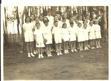 Streatham and District Historical Society
Picture, Streatham State School 1947
The children are standing infront of a line of trees. Dress is summer, all wearing shorts and shirt. Streatham State School students 1947. Back Row, L to R Shelia Davis, Heather Dorrington, Noel Oman, Barbara Brown, Phyllis Olney, Billy Brown, Peter Eastick, Geoff Wills. Middle Row, L to R, Dossie Chew, Deidre Chew, Joyce Davis, Margaret Forbes, Helen Wills, Marjorie Dorrington, Barry Brown, Myrna Blurton. Front Row, L to R, Pat Davis, Unknown, Donny Blurton, Ester Smith, Billie Eastick, Margaret Ward, Faye Dobson, John Dorrington, Geoff Ward.Shows the size of the school in Streatham at that stage and indicates the population around the area of StreathamRectangular shape Black & white pictureKodak stamp on back1947, streatham, state school victoria, carranballac -
Ringwood and District Historical Society
Biography, Ringwood and District Historical Society, Interview notes - short biography on Miss Daisy Paddock, teacher at Ringwood State School, circa 1970s, c.1970s
Single page of notes/interview record of Miss Daisy Paddock, teacher at the Ringwood State School in Greenwood Avenue (now Federation Estate) - Interview write-up by Ringwood History Group.Transcript: "Miss Janet Daisy Paddock She was an extremely well-liked and well-regarded teacher at the old RW State School in Greenwood Ave (Now Federation Estate). She taught between the years of 1927 until 1941, then again after the war from 1951 until final retirement in 1961. In fact she was so liked that her former pupils formed "The 2997 Club" , which met in her honour every year for a meal (and, of course, their guest of honour). 2997 was the RW SS number. In some of her letters about early life in RW, she recalls the RW Mail being produced and printed in a small wooden building in Adelaide St. [Adelaide St is officially no longer on the RW map but it went from the highway nearly to Mullum Creek, between Melbourne St and Warrandyte Road.^ In fact there is an unmarked 100 metres of road that is on the west side of Officeworks that ends in a roundabout at the bottom of Eastland carpark. I don't believe it is exactly in the same position as the old Adelaide Street but it pretty close. That would put the old Mail office in the vicinity of the Maroondah Council service centre in Eastland.] She also recalls that there were nearly a dam on every corner. In fact, I recall in my 1950s/60s childhood that there were still many dams around. As I previously mentioned, with the RW-Mitcham claybelt, there wasn't much top soil and the orange clay is very fine, so when the banks of the dam get wet, it wass very slippery. I often remember playing around in those dams, as most boys did in those days. A friend and I spied an old bath used to water some horses so after some trial and errors we made it waterproof and fashioned a couple of paddles out of wooden fence pailings. The first launch in the local dam was fine and we managed to manouver through the bullrushes into the middle. The only thing that I forgot about was that I had a d<^ that went everywhere with me and, rather than bark from the bank, he swam over to us and tried to get aboard. Bath tubs are not known for their seaworthness and he tipped us all in the drink. Of course the bath sank like a rock. We scrambled on the bank and he added insult to injury when, as all dogs do, gave the usual shake and sprayed us with water. My mind often comes back to one dam right next to the Croydon pub - that provided water to the Magg's orchard - dug in the usual fashion on about 3 metres deep scraped in the local clay, it was at this dam in the early sixties that a young boy drowned. After that we were pretty careful around dams. Going back to Daisy's memories, she recalls that the kids often started late on Monday mornings as Monday was Market Day at RW. They used to watch the stock being herded into the yards and people getting off the steam trains. Her family home was at Gruyere and her father used to drive to RW market and stop midway at the Burnt Bridge hotel and rest the horses. [I suspect that he may have watered other things besides the horses.] They eventually moved to RW in Thanet St. Miss Paddock still remembers the old RW school at the corner of RW St and Whitehorse Road, it was very small so they built the new school in Greenwood Ave. RW had a population of around 2,(K)0 when Daisy became an Assistant Class Five. She used to walk through the open paddocks, surrounded by bush and orchards. She goes on to say that the bush was alive with wildlife and a natural playground for the children. Miss Paddock was a member of the Soroptomist Club in RW (equivalent to Rotary), active in the church and local community. At our archives, we have a plaque that grac^ the entrance to the school, naming it the Miss Daisy Paddock library, in honour of a great woman in our city." -
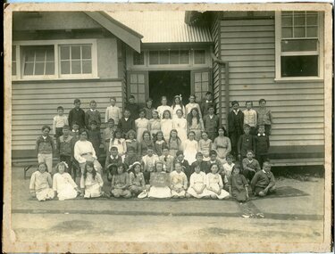 Orbost & District Historical Society
black and white photograph, 1915
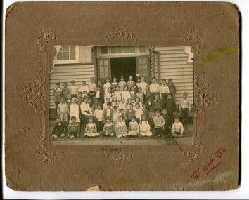
This is a photograph of students at Orbost State School in 1915. Included in the photograph, as identified by Mary Gilbert' are Brian Harrison; ?; ? Whillance; Rupert Perry; ; Dolly Nixxon; Dot Stagg; Ella Cowell; Annie Macalaster; ? ?; ? Winchester; Rupert Bird; Mac Kerr; :; Clarrie Reynolds; D. Daly; Marion Watt; Audrey Cameron; Teen Dixon; Ethel Morris; ?; Toby Nixon; Charlie Winchester Miss Marie Haynes; Doris Smith; Alison Cameron; Ruby Morgan; Thida(?) Guy; Elsa Wehner; Gladys Boucher; Gloria Swanson; ? Lay; ? Rodwell Wally Simpson; ? Morgan; Reece Harrison; P. Summers; ?; Les Morgan; W. Lawless; ? Craker; A. Nish; P. Hocking Zenie Irvine; Essie Nixxon; Violet Gibbs; Adelaide Hardy; Verna Perry; Mary Gilbert; Margaret Irvine; Marge Henderson; Nellie Draffin; Roy Cameron The 19th of March 1886 proved an important day in the lives of many early settlers in the Orbost area, because on this day the Orbost State School opened. The fact that the school had first operated temporarily in a leased building, and on a half-time basis with SS2745 Jarrahmond, did not dampen the enthusiasm of the local inhabitants as they saw their offspring commence their education under the guidance of HT Campbell Mackay. However he remained in charge only until 12th of May 1886. The second HT, John Rowe, served until 1908. On 30th of June 1887, a portable room was provided; it being brought to the area by schooner. The school now had accommodation for 30 pupils; the teacher's welfare was considered because quarters of two rooms were attached. As the population increased so did the needs of the school. This was reflected in the provision of a larger classroom in 1898.This photograph is associated with the history of education in Orbost.A black / white photograph of a group of children and one female teacher in front of an open doorway of a wooden school building. agirl seated in the front row is holding a board with "Grades V V1 Orbost" hand-written in what appears to be white chalk on a blackboard. .A list of those in photograph is attached.on back - "Grades V V1 Teacher Miss Merle Haynes who is now married, graduated at Monash, Maisie Ross holding board. Mary Gilbert on her right in picture"education-orbost-state-school -
 Orbost & District Historical Society
black and white photograph, Wilson, Les G, first half 20th century !930s-40s?
This is a photograph of students of Orbost State School. Those in the photograph have been identified by Mary Gilbert. Back Row - Billy Nixon; ?; ?; ?; Albert Williams; Stan Porter; Stan Farmer; Bert Johnston; Betty Gilbert; Bernice Feltis; Olive Gall; Lorna Farquahar: Bessie Gibbs; Cora Morgan; Dorothy Broome ?: Jack Gargan; Bill Dreverman; Tom Stevenson; George French; ?; Jim Nixon; Dorothy Tipping; Lorna Sadler; Ivy Swan; ?; ?; Edie Gall; ? ?; ?; Ray Tyrell; ?; ?; Tom Rodwell; /; Una Perry; Perth Hardy; ?; Molly Pardew; Alice Hammill; Effie Hammill; Muriel Grose; Francie Robinson; Marion Gilbert Jim Tipping; Dave Murray; Arthur Simpson; ? Grose The 19th of March 1886 proved an important day in the lives of many early settlers in the Orbost area, because on this day the Orbost State School opened. The fact that the school had first operated temporarily in a leased building, and on a half-time basis with SS2745 Jarrahmond, did not dampen the enthusiasm of the local inhabitants as they saw their offspring commence their education under the guidance of HT Campbell Mackay. However he remained in charge only until 12th of May 1886. The second HT, John Rowe, served until 1908. On 30th of June 1887, a portable room was provided; it being brought to the area by schooner. The school now had accommodation for 30 pupils; the teacher's welfare was considered because quarters of two rooms were attached. As the population increased so did the needs of the school. This was reflected in the provision of a larger classroom in 1898. During 1910-11 the first approaches were made to the Department for the establishment of a HES in Orbost and this became a reality in 1912. Orbost HES supplied post-primary education in the district until a high school was built in 1948.This photograph is associated with the history of education in Orbost.A black / white photograph mounted on brown card. It shows a group of school children in front of an outside wallm of of a timber building. A boy in front is holding a board with "Grades 1V & V" written on it.A hand-written list of names is attached to the photograph. There is an arrow with "MARION" next to it. At top - BETT -
 Orbost & District Historical Society
black and white photograph, Wilson, Les G, C 1915
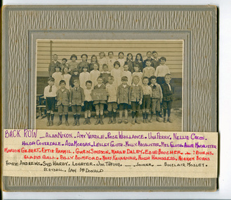
This is a group of students of Orbost State School. A list of those in the photograph has been hand-written by Mary Gilbert. Back Row- ?; Alan Nixon; Amy Yandle; Rose Whillance; Una Perry; Nellie Cross; Hilda Coverdale; Ada Morgan; Lesley Gluth; Molly Macalaster; Mel Gluth; Allie Macalaster Marion Gilbert; Ettie Hammill; Gwen Simpson; Marge Daley; Edie Boucher; ?; ? Burns; Gladys Gall; Billy Momford; mary Kavagnah; Hugh Hawkless; Norman Burns Royce Andrews; Syd Hardy; ? Lowater; Jim Tipping; ?; ? Joiner; ?; Sinclair Mosley; ? Pleydell; Ian McDonald The 19th of March 1886 proved an important day in the lives of many early settlers in the Orbost area, because on this day the Orbost State School opened. The fact that the school had first operated temporarily in a leased building, and on a half-time basis with SS2745 Jarrahmond, did not dampen the enthusiasm of the local inhabitants as they saw their offspring commence their education under the guidance of HT Campbell Mackay. However he remained in charge only until 12th of May 1886. The second HT, John Rowe, served until 1908. On 30th of June 1887, a portable room was provided; it being brought to the area by schooner. The school now had accommodation for 30 pupils; the teacher's welfare was considered because quarters of two rooms were attached. As the population increased so did the needs of the school. This was reflected in the provision of a larger classroom in 1898. During 1910-11 the first approaches were made to the Department for the establishment of a HES in Orbost and this became a reality in 1912. Orbost HES supplied post-primary education in the district until a high school was built in 1948. This photograph is associated with the history of education in Orbost.A black / white photograph mounted on grey card. It shows a group of school children posed in rows in front of an outside wall of a wooden building. A boy in the front row is holding a sign with "GRADE " written on it. The sign appears to be in white chalk on a blackboard.There is a handwritten list of names attached to the bottom of the photograph.education-orbost-state-school -
 Orbost & District Historical Society
black and white photograph, Vogt, Stanley, C 1915-1920
This is a photograph of students of Orbost State School. Mary Gilbert has identified the girl holding the sign as Pen Gilbert. The 19th of March 1886 proved an important day in the lives of many early settlers in the Orbost area, because on this day the Orbost State School opened. The fact that the school had first operated temporarily in a leased building, and on a half-time basis with SS2745 Jarrahmond, did not dampen the enthusiasm of the local inhabitants as they saw their offspring commence their education under the guidance of HT Campbell Mackay. However he remained in charge only until 12th of May 1886. The second HT, John Rowe, served until 1908. On 30th of June 1887, a portable room was provided; it being brought to the area by schooner. The school now had accommodation for 30 pupils; the teacher's welfare was considered because quarters of two rooms were attached. As the population increased so did the needs of the school. This was reflected in the provision of a larger classroom in 1898. During 1910-11 the first approaches were made to the Department for the establishment of a HES in Orbost and this became a reality in 1912. Orbost HES supplied post-primary education in the district until a high school was built in 1948.This photograph is associate with the history of education i n Orbost.a black / white photograph mounted on brown card. It is of a group of school children in front of an open doorwaay of a timber building. A female teacher is seated on a chair among them. A girl in the front is holding a board with what appears to be handwritten in white chalk on a blackboard -"Grades 111 & 1V Orbost".at bottom - "X PEN GILBERT"education-orbost-state-school -
 Orbost & District Historical Society
newsletters, Goongerah Grapevine, July 1998 - August 2005
Goongerah is a community on the Brodribb River, located in Gippsland, about seventy kilometres north of Orbost. The town's population is about sixty. Goongerah Post Office opened on 21 November 1952 and closed in 1974. Goongerah had one of the smallest primary schools in Victoria, with about 11 students. The school no longer functions. These newsletters were produced by members of the community and distributed locally.In small rural communities newsletters have been important tools for facilitating community development while fostering a sense of belonging and attachment to the community.A yellow plastic covered folder containing black / white printed newsletters. There are fifteen copies of "Goongerah Community News" and thirty-nine copies of "Goongerah Grapevine". All include news from the C.F.A., Forest News and articles from Goongerah Primary School.label on front- "COMMUNITY NEWSLETTERS Goongerah 1998 - 2005" -
 Orbost & District Historical Society
black and white photographs, November 1976
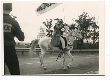
All of these photographs were taken prior to 25th November, 1876, the official opening and crossing of the current Snowy River Bridge. Gary Downey, an Orbost Apeian, did a "De Groot" and crossed the bridge on horseback prior to the official cars crossing the bridge to signal the opening of the new structure. There was a closing ceremony for the old bridge with a group arriving in a 1927 Chrysler, owned by Apexian, Peter Dreverman. This was watched by groups of school students. Some of the Apex members, including Jim Duggan, Noel Smart and Pat Hall, dressed in formal attire to speak to the audience.This event was organised by the Apex Club of Orbost.The Apex Club of Orbost was a volunteer service club which contributed to the Orbost community. A declining population has led to the demise of many social groups in the area.Ten black / white photographs related to the unofficial opening of the Snowy River Bridge at Orbost. snowy-river-bridge-1976 apex-club-orbost ceremony -
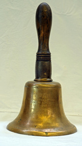 Orbost & District Historical Society
Functional object - Bell, hand-held, Early 20th century, c.1900s
... in the area. The increased population allowed the school to have more... in the area. The increased population allowed the school to have more ...The settlement of Cabbage Tree Creek is located on the Princes Highway, 27 km east of Orbost in East Gippsland. The creek, which flows through undulating forest, takes its name from the patches of Cabbage Fan palms growing along its course. A school commenced classes in 1913, but enrolment was small and at times the school operated part time with several other small schools in the area. The school building served as a hall for the district. About 1946 two sawmills commenced operations at Cabbage Tree Creek, and the Forests Commission ranger was stationed in the area. The increased population allowed the school to have more teachers and make improvements. In 1953, a new prefabricated building was erected on a new site. However, by the 1970s employment in the timber industry was unstable and the population decreased. By 1974 the school again had only one teacher and eventually closed in 1993 to amalgamate with the Orbost primary School in Ruskin Street, Orbost. (Ref. VictorianPlaces)The school bell is a signal that tells a school's students when it is time to go to class in the morning and when it is time to change classes during the day as well as when students are dismissed from school. In most schools today it will be a tone, siren, electronic bell sound, a series of chimes, or music played over an intercom but often still called "the school bell". This item reflects the history of Cabbage Tree Creek as well as the technological changes in the school system.Brass bell with incised double lines on bottom edge and top near handle, featuring descriptive notation on front face. Bell has long wooden handle shaped and incised with four lines at base before brass housing with singular screw holding handle in place. Object is showing signs of wear, with blackened handle and patches of green oxidisation.SCHOOL BELL / SS No 3812 / CABBAGE TREE CREEK / PRIMARY SCHOOL / 1913-1993 / FORMALLY INCORPORATED / INTO / ORBOST / PRIMARY SCHOOL / 1994cabbage tree, east gippsland, cabbage tree creek, cabbage tree creek primary school, orbost primary school, school bells -
 Orbost & District Historical Society
book, Hepburn, Dorothy, State School Number 3267 Lower Bendoc East Gippsland Victoria, C 2002
Located near the NSW border in the far east of Victoria, the Bendoc school served the needs of a rural population which opened the land to grazing at the turn of the century. It opened on September 8 1896. In December 1956 falling attendances forced the Education Department to close it. It is interesting to note that children here sought their secondary education in NSW. The first head teacher) was John M. Cass and the last R R King. In 1953-54 Lower Bendoc operated part-time with Goongerah. In 1955 it regained full-time status, but in 1956 worked part-time with Tubbut. Author, Dorothy Hepburn, attended Bendoc State School.This is a useful reference tool on the history of Bendoc.A spiral bound book with a plastic sheet front. The cover is white with black print and a b/w photo of a man sitting on a wooden chair outside a log building . Underneath is written "FROM HUMBLE BEGINNINGS TO FINAL CLOSURE".bendoc-state-school -
Federation University Historical Collection
Document, Zelda Martin, Central Victorian Goldmining towns - Boom Towns or Ghost Towns?, c1996
Zelda Martin was a PhD candidate at the University of Melbourne.[.1] 4th item in light blue display book titled Research Approach/Overview of Chapters/Confirmation of Canditure/Chapters1,2,3&4 of proposed thesis. *Twenty-seven page article on Victorian goldfields towns titled: Central Victorian Goldmining Towns - Boom Towns or Ghost Towns. The article was written during the author's PhD study. It outlines the context methodology, and resources and the chapters of the proposed thesis: (1) Central Victorian Goldmining Towns - The Context (2) Contemporary Views of the Factors Necessary for Town Growth (3) Outward Manifestations of Town Growth (4) The Trappings of Government (5-9) The Main Towns and Their Hinterland. [.2] 5th item in Light Blue display book as above item. *Chapter 1 of proposed thesis titled 'Pick, Shovel and Tin Dish Mining.' Covers in Section A: Central Victoria - Pre 1851: Aborigines in Central Victoria, Squatters, and Government. Section B: The years 1851-1854: The Early Gold Rushes, Government Reaction, Township Surveys, Legislation, Town Development, Local Government and Early Settlement. [.3] 6th item in Light Blue display book as above item. *2A of proposed thesis titled 'Contemporary Views of the Factors Necessary for Town Growth'. Similar information to Chapter 1 plus extra re towns and maps. Sections: Introduction, Context of Place - Geographical Towns Listed, The Context of Time - Pre1851 Aborigines, Governance of Port Phillip, The Squatters, The Villages of Central Victorian Highlands, Conclusion, Condensed Version of Chapter2B. [.4] 7th item in Light Blue display book as above item. *Chapter2B of proposed thesis. Sections: Area of Research, Schools, Banks, Newspapers, Progress Association, Town Development - Sandhurst (Bendigo), Ballarat, Castlemaine,, Maryborough, Ararat and Stawell. [.5] 8th item in Light Blue display book as above item. *Chapter 3 of proposed thesis titled 'Outward Manifestations of Town Growth'. Sections: Introduction, Contemporary Writing, Educationalists, The Bankers, The Townsfolk, Current Theory, General Theories of Urban Development, and Conclusion. [.6] 9th item in Light Blue display book as above item. *Chapter 4 of proposed thesis titled 'Trappings of Government' Sections: Introduction, Early Government Attitudes to Mining and Town Development, Law and Order, Township Surveys, Legislation, Local Government, Transport and Communication, The People and Lobbyists. [.7] 10th item in Light Blue display book as above item. *'The Rise and Fall of Central Victorian Goldmining Towns'. Includes a map showing main Goldfields, a table showing towns and villages at two points in time - 1857 and 1871; a Bibliography of Primary and Secondary Sources. [.8] Resource No1. Black display book titled Local Towns 1 : Alma: *Brief history *Directory *Maps Amphitheatre / Mountain Hut: *Brief History Post Office Directory Ararat: *Brief History *Post Office Directory 1869 - Alphabetical Listing by Occupation *Ararat - Prominent Citizens of 1858 *Langi-Morgala Museum Avoca: *Brief History *Excerpts from 'Avoca The Early Years', Margery and Betty Beavis; pg1 - Beginnings; pg11 - The Midas Touch; pg25 - Local Gold Escorts; pg27 - A Town is Born; pg51- The Administration of Justice; pg53 - The Ways of the Law; pg61 - News of the Day; pg65 - A Time to Play; pg72 - Land Ownership *Post Office Directory (Bailliere's) 1869 *Tourism Map and Information of area *Historic Avoca - A 5.5km Tour *Avoca & the Pyrenees Region - information pamphlet Ballarat: *Early History of Ballarat - Ballarat Historical Society, Publication No.1: origin of the name; Ballaarat - the Beginning; Fabulous Yields from the Ballaarat Goldfield; *Streetscape Lydiard Street. *Hand drawn map showing Leigh River, Old Portland Bay Road, plaque on road to Colac; etc. *Newspaper article re 'The Theatre Royal' ( which stood in the vicinity of the current Owen Williams store) - 'The News'15/04/1998 *Article - 'Ballarat's Mechanics' Institute Lives On' Ballarat Courier, 14/09/1985 *Article - Standing the Test of Time' The News 17/11/1993 re The Mechanics Institute & picture of the Reading Room *'Ballarat a Study of a City, Phyllis Reichl, pub. Nelson, 1968; no.3 place, time and people field studies series *Investigator Vol.33 No.2, 1998 Geelong Historical Society. Article on pg75 describes Ballarat in 1861 *Folded poster - 'Ballarat 100' a history of telegraph communication, pub. Telecom. Beaufort (Fiery Creek): *Brief history *Post Office Directory [.9] Resource No.2 Black Folder Titled Towns cont.No2 Bendigo (Sandhurst): *'Family & Local History at the Bendigo Library - 1851-2001 150 years of gold'. *Bendigo Government Camp in 1853 illustration; key to sketch and names of Government officers stationed there *Excerpts from 'Bendigo and Vicinity' Adolph Haman *The Bendigo Goldfield Registry - pgs 1-7 Introduction *Excerpt: 'Breaking the Grip' *Excerpt: The Most Go-Ahead Place *Excerpts from 'History of Bendigo' - anti license agitation; laying out of town; proposed railway; gold calls and dividends; the Sandhurst Municipality; journalism *Bibliography Blackwood: *Excerpts from 'Aspects of Early Blackwood - The Goldfield, the Landmarks, the Pioneers' Alan J Buckingham and Margaret F Hitchcock, JG Publishing,1980 Buninyong: *A Brief History *Investigator Vol1 No.2 Feb 1966 Geelong Historical Society. Pg3 - Article re gold escort route - Mt Alexander to Adelaide - (see a simple monument on the Western Highway a few miles out of Horsham. Pg 15 - Ballarat Excursion - re the finding of gold. *Three articles published by Buninyong and District Historical Society Inc: (Magpie Exploration; Finding Gold In The Green Hills; Magpie Exploration; Burnt Bridge to Cargarie to Mt Mercer) *Copies of newspaper articles/items *Buninyong Street Directory Carisbrook: *In the Beginning There Was Carisbrook *The History of the Carisbrook Racecourse Carngham / Snake Valley: *Brief History *Directory Castlemaine: *Directory 1865-1866 - Alphabetical and Street *Poster - Castlemaine A Contemporary Guide "The Great Centre" 1866 - A Contemporary Guide to the Fascinating Past *Pamphlet - Castlemaine District Community Hospital *Map - Castlemaine, Maldon & Surrounding Districts *Map and Information - The Dry Diggings Track - a 55kl walk among historic goldfields relics ( Castlemaine Fryerstown Vaughan Mt Franklin Hepburn Daylesford) *Postcard - Former Court House *Directory 1867 - Alphabetical, Trade [.10] Resource No.3 Grey folder Titled Towns 3 Creswick to Maryborough Creswick: *Brief History *Booklet - "Creswick Cemetery Walk" *Booklet - The Buried Rivers of Gold Heritage Trail Creswick *Creswick Historical Museum Information Sheet *Chronological History of Creswick *Alphabetical Directory of the Borough of Creswick *Creswick's Creek Directory 1856 *Historic Creswick Walking Tour *A Brief Account of the Schools of Creswick - Past and Present *100 Years of Railway Travel in Creswick *The Berry Deep Leads *The Spence Home at Jackass Gully in the Creswick State Forest ( William Guthrie Spence - Pioneer) *The New Australian Mine and the 1882 Disaster *Creswick District News, Issue 7, July August 1999 *The Creswick Miners Walk - Information and Map *Maps Chewton: *Brief History *Directory Clunes: *Brief History *Clunes Street Directory Daylesford: *Brief History *Notable Bushfires in Daylesford District Over More Than a Century - "Black Thursday" 1851; 1862; 1899; the Disastrous Hepburn Fire of 1906; 1939; 1944; 1969. *Post Office Directory -Daylesford and Hepburn Dunolly / Inkerman: *Brief History *Directory *Pamphlet - Goldfields Historical Museum *Pamphlet - Historic Dunolly - Victoria's Best Kept Secret *Map of Gold Workings at Dunolly Area - showing where the main gold rushes occurred *Brief History - Inglewood *Directory - Inglewood - Name Occupation, Dwelling Kingower: *Brief History *Directory - Name / Ocupation / Dwelling Linton / Happy Valley / Piggoreet: *Brief History *Directory - Lintons McIvor: *"A History of the Shire and the Township of Heathcote" by J.O. Randell Majorca: *Brief History *Official Post Office Directory 1869 - Name / Occupation/ Address Maldon (Tarrangower): *Brief History Part 1 *Brief History Part 2 *Post Office Directory *List - Alphabetical Order by Names plus Business and Trade (Tarrangower Times Oct/1858) *List - Alphabetical Order by Trade plus Name and Business *Directory - Name / Occupation / Dwelling Maryborough: *Worsley Cottage - built by Arthur Worsley, a contractor in stonework in 1894 [.11] Resource No. 4 Blue Display Book titled Towns 4 Moliagul to Stawell Moliagul: *Brief History *Moligul Legislative Assembly (Voting?) List - Names and Occupations *Moliagul Victorian Post Office Directory 1868 - Name / Ocupation / Address / Comments *"The Welcome Stranger" gold nugget *The Sunday School *The Welcome Stranger Discovery Walk - information and map Moonambel (Mountain Creek) Redbank *Brief History *List of names extracted from advertisments of the Pioneer and Mountain Creek Advertiser 16/02/1861. *Bailliere's Directory 1869 - Alphabetical List of Name / Occupation / Place St Arnaud: *Brief History Sebastapol: *Brief History *Directory 1869 - Alphabetical by Name; plus occupation and address. Browns and Scarsdale: *Brief History *Browns Street Directory - Name and Occupation Smythesdale: *Brief Description *Smythesdale Street Directory -Name and Occupation Stawell (Pleasant Creek) *Brief History *Victorian Official Post Office Directory - Name /Occupation / Dwelling *Chronology - 1841-1920 *Production of gold statistics - 1879 - 1900 *Big Hill *Extracts from "The Golden Years of Stawell". Chapt 1 - Stawell's Coming Out. Capt. 2 - The Gold Rush. Caapt.3 - Cradle of Democracy. Chapt.4 - The Reefs Becomes Stawell. Chapt. 5 - Rushing In. Chapt.6 - The Pioneers. Chapt 7 - The Decade of Optimism. [.12] Resource No. 5: Blue Display Book titled 'Towns Steiglitz to the The Golden Triangle. Steiglitz: Brief History Victorian Post Office Directory 1869 *Map of Steiglitz *List of maps relevant to Steiglitz history *Information 6 tables of data from "Reports of Mining Surveyors Talbot (Back Creek) Brief History Taradale: Post office Directory 1869 - Name/Occupation/Street. Also list in alphabetical order by Occupation Taradale *Chronological Reference to Taradale Mines *Water - The Coliban System of Waterworks *Joseph Brady *The Syphon Tarnagulla (Sandy Creek) *Brief History *Tarnagulla Businessmen Cameos to give depth to advertisments in 'The Tarnagulla Courier' various issues 1864-1871 *Directory - Name/Occupation /Address *List - Name/Business/Trade Wedderburn (Koorong) *Brief History *List - Name/Occupation The Golden Triangle: *The Early Rushes - Wedderburn / Moliagul / Sandy Creek - Tarnagulla / Jones Creek - Waanyarra / Kingower / Dunolly - Goldsborough / Inglweood *Census of 1857 - Population / Occupations *1858-1871 - A Time of Consolidation- Wedderburn / Moliagul / Sandy Creek- Tarnagulla / Arnold *Census 1871 - Population *Information gleaned from the census data - Demographics / Population / Occupations / marital / Birthplace / Religion / Literacy/ Occupation and Housing Cameos *Graphs - Birthplace of settlers /Male-Female Ratio / Married males / Children under 15 as Percentage of Population / Religion *Census 1857 - Statistical data *Maps *Bibliography [.13] Resource No. 6 - Black Display Book Information and Research in Central Victoria including: *Banking - Research from ANZ Bank Archives *Institutions - also includes articles listed from the Ballarat Times Newspaper *Australian mining History Association - A.M.H.A. Bibliography *Australia's Mining History * Bibliography - Land Surveys Victoria - *1853 Administration (Statistics and Other) includes: schools / ministers of religion / police / military / local administration / licences for sale of spirits / distances between various Victorian gold fields. * Victoria Government Gazette (Copy) - N0. 116, 12/12/1854 includes: Gold Felds Commission of Enquiry & No. 85, 15/09/1854 - Addresses presented to the Lieutenant Governor (Sir Charles Hotham) during his tour through the Gold Fields of Victoria,1854. Addresses on behalf of : the people of Bendigo; Members of the Church of England, Bendigo; Members of the Wesleyan Church on the Bendigo Gold Fields; Bendigo Gold District General Hospital; the Bendigo Prospecting Association; Committee of the Bendigo Local Exhibition; Bendigo District Medical Association; Coloured Americans Resident at Bendigo; German Inhabitants of Bendigo; Landowners, Inhabitants, and Miners of Castlemaine; Inhabitants of Forest Creek; Inhabitants of Heathcote and Gold Miners of McIvor; Residents and landholders of the District of Bacchus Marsh; Inhabitants of Kilmore and Vicinity. *Gold Fields Correspondence 1853: letter from Lieutenant Colonel Valiant, (Officer commanding the Troops in Victoria) to the Lieutenant Governor re threatened disturbance at Sandhurst (Bendigo) regarding the Gold License Fee. * Extracts from a book "Victoria" re Gold Fields Commission of Enquiry involving mainly Ballarat and Castlemaine and a chapter titled 'A Tour to the Victorian Gold-Fields' *Lists of central Victorian newspapers - listed by date published 1851to 1874; by first date available to State Library. *A list of cities and towns showing County, population in 1861 &1871, and municipal status. [.14] Resource no.7. Black display book. *Reference: Papers presented to Parliament Victoria - 1859-1860 4 volumes - relevant sections copied. Contains information on Branches of Government. General / Finance / Gold / Gazette / Commission and Warrant / Statistic. *Gold Fields Act. In accordance with the Act the gold fields are divided into six districts - Ballaarat, Castlemaine , Sandhurst, Avoca, Ararat, and Beechworth.. Official staff in each gold district consists of a Resident Warden, Wardens, Wardens' Clerks, Bailiffs, Chinese Protectors, Chinese Interpreters, and Mining Surveyors. *Gold Receiver *Gaols *Police magistrates and Clerks of Petty Sessions, etc. *Field Branch *Immigration and Emigration Overland - Chinese - 1859 *Population on the Goldfields *The Geological Survey - The Government Geologist is assisited by staff from four branches - the office Branch; the Publishing Branch; the Field Branch and the Museum Branch. *Commission to Enquire Into Sludge dated 10/02/1859 (Some sections copied) - Report to the Honorable Chief Commissioner of Public Works, Melbourne re the mode of carrying the sludge from the puddling mills in Sandhurst without interfering with the drainage of the town and the roads in the neighbourhood. [.15] Resource No.8: Camel display book titled Resource No. 8. Aborigines *Lists of book titles - +"Readings in Victorian prehistory" +"The Aborigines of Port Phillip" +Aboriginal languages and clans" +"A History of the Port Phillip District" +"Langi Ghiran 1: Aboriginal Rock...." +"Koorie History: sources for aboriginal studies in the State Library of Victoria", ed. Tom Griffiths, Melb. Friends of the State Library, 1989 +"The Public Lands of Australia Felix"; settlement and land appraisal in Victoria1834-91 with special reference to the Western Plains", J.M.Powell, Melb. Oxford University Press 1970 +*Bibliography of the Victorian Aborigines' from the earliest manuscripts to 31st December 1970, Massoa, Aldo, Melb. Hawthorn Press, 1971 +"Aborigines in Colonial Victoria, 1836-1886", M.F. Christie, Sydney University Press, 1979 +"Urban and Industrial Australia: readings in Human Geography" ed J.M. Powell, Melb. Sorrett Pub. 1974 *Extracts: -Processes of Pioneer Settlement - The Squatting Occupation of Victoria, 1834-60. J.M. Powell -Areal Variations in the Class Structure of the Central-Place Hierarchy. P. Scott - Volume1 and Volume 2: Notes Relating to the Habits of the Natives of Other Parts of Australia and Tasmania. Compiled from various sources for the Government of Victoria by R Brough Smyth. John Curry, O'Neil, Melb. 1st pub. Melb. 1876. p31-45 - Numbers and Distribution of the Aborigines in Victoria -Victorian Aborigines 1835-1901 - A Resource Guide to the Holdings of the Public Record Office, Victoria; published by the Government Information Centre 1984. *History of the Aboriginal Artefacts Displayed in the Daylesford Museum. F. G. Powell (4 page pamphlet) *Letter to Zelda Martin from Peter Lovett, Cultural Officer, Ballarat & District Aboriginal Co- Operative, 05/02/1997 *Map: Ian Clarke Victorian Tribunal Boundary Map - Clans of Central Victoria. *Victorian Rock Art and Mythology - Article about Mount Langhi Ghiran and myths of the Tjapwarong people. *Two Aboriginal myths relating to the Grampians - 'The Monster Emu' / 'The Aquisition of Fire', by the Aborigines in the Grampians Areas *Article titled (chapter 8) Ballarat - information re camping sites in the region. Lake Wendouree / Lake Burrumbeet (includes a myth) / Mt Bunninyong / Lal Lal / Pitfield / Mount Elephant / Mount Egerton / Meredith / Lake Goldsmith / Lake Learmonth / Ercildoune *Notes on the Aborigines of the Wider Ballarat Region plus European names=Aboriginal names. John Morris 26/07/1995 *Role of Aborigines in Town Development in Central Victoria. Mentions Native Police Force est. in Port Phillip 1842 and Central Board for Aborigines est. 1860 *The Grave of King Billy. (Frank Wilson) Pamphlet. *Camping Places in Central and Northern Victoria. Article re Lake Burrumbeet site. *Programme for the Unveiling of Memorial Cairn for Edward Stone Parker 1802-1865. Note portrait not accurate. Accurate portrait is available in the book "A Successful Failure A Trilogy The Aborigines and Early Settlers", Edgar Morrison, Graffiti Publications, 2002. * Large envelope addressed to Mr G Netherway containing newspaper cuttings regarding the life of Edward Stone Parker, the unveiling of the Memorial Cairn as mentioned above, articles titled 'Episodes from Our Early Days' (Edgar Morrison, Yandoit)- The Black's School, A School At Last and The Final years. Also a typed page titled 'Historical Background to E.S.Parker's Career. Includes an interesting tale titled 'When the cat lay doggo' re laying power leads for the unveiling ceremony at the memorial site. [.16] green display folder titled 'Research Aids' *List of references to Commissioners' & W'ardens' Reports (formerly held at La Trobe Library Archives, now at Public Records Office [PRO]). Indicates town referred to / date of report / name of camp if different to town. * Archive information re Anglican Records *Movement around the Goldfields - Miners and Storekeepers - usefulness of newspapers in providing information - areas covered - Castlemaine, Maldon, Ararat, Stawell, Tarnagulla, Dunolly. *Port Phillip /Victoria Directories 1839/1867 - Chronological list of Directories included in this series. *"Notes on the History of Local Government in Victoria" A.W. Greig Melb. University Press 1925 - Photo-copied extract p5-p40. (Source - Deakin University Library) - Introduction by W.Harrison Moore. Section 1 - Development in New South Wales Before Separation. Section 2 - Development in Victoria After Its Separation from New South Wales. Hand written notations: 'roads, markets, and local government 1855 on' ;'opportunity of squatters in parliament' and 'opportunities of matters in parliament p33' * Notes on the Establishment of Surveyor General's Department 1851and Commissioner of Crown Lands and Survey. * Newspaper articles from The Argus, 1849, re the discovery of gold in the Pyrenees region. * Excerpt - a report on schools - A.B.Orlebar, Inspector; re the need for permanent school buildings rather than tents. *Excerpt from - 'Approaches to Urban History', Sean Glynn: The Case for Caution * Except from - 'The Urban Sprinkle', Weston Bate: Country Towns and Australian Regional History *Reference- 'The History of Land Tenure in the Colony of Victoria', John Quick. References the Haines Land Bill, land tenure and Land Leagues. [.17] Light blue envelope folder titled 'Birtchnell's Ballarat, etc. Directory 1862 *Contains various directories for Smythesdale, Buninyong, Clunes, Brown's and Creswick. [.18] Red envelope folder no.2 titled Victorian Gazetteer *Selected pages from 1869 Victorian Gazetteer on A4 paper (with a handwritten note questioning if some pages are from 1868 Victorian Gazetteer as appears to be different sizes - A3 pages.) Information includes locations and descriptions of towns, hotels, banks, communications and populations. (Does not include names, residences and occupations) [.19] Red Envelope folder titled Bailliere's Official Post Office Directory 1868 (or1869 or a mixture of both?) *Preface *Contains a selection of pages of towns highlighted in yellow in the the index *Work on this directory was commenced in 1867. *Information includes: Municipalities - mayors and councilors; lists of towns naming male inhabitants and their occupations. [.20]Yellow manila folder titled Post Grad Seminar Presentation 1996 *Gives some background to Zelda Martin's proposed thesis and why she chose the topic Gold Mining Towns Boom or Bust [.21] A3 display book - No. 1A * A list of 'Relevant Newspapers collected: The Tarrangower Times and Maldon Advertiser (first published 1858) Includes dates 1858-1867. The Mount Alexander Mail. Includes dates 1854-1866 The Tarnagulla Courier. Includes dates from1864-1871 Dunolly and Burnt Creek Express. Includes dates from 1862-1871 * Selection of newspaper pages from The Mount Alexander Mail 1854 to 1856, mostly showing advertisements for businesses and services provided to that community. [.22] A3 display book - No. 1B * Selection of newspaper pages from The Mount Alexander Mail 1857 to 1866, mostly showing advertisements for businesses and services provided to that community. [.23] A3 display book -No. 2 * Selection of newspaper pages from The Tarnagulla Courier 1864 to 1871, mostly showing advertisements for businesses and services provided to that community. [.24] A3 display book - No. 3 *Selection of newspaper pages from The Tarrangower Times (and Maldon and Newstead) Advertiser 1858 to1867, mostly showing advertisements for businesses and services provided to that community. [.25] A3 display book - No.4 * Selection of newspaper pages from The Dunolly and Burnt Creek Express; and The Dunolly and Betbetshire Express 1862 to 1871, mostly showing advertisements for businesses and services provided for that community. [.26] A3 display book - No.5 Includes: * Bryce Ross's Diggings Directory. Includes instructions for using this directory. This directory was used by "all persons having connexion or desiring to communicate with 'working parties, private friends, or Stores at the Diggings." As a directory for each area wwas completed it was published in each month's issue of Bonwick's "Digger's Magazine." Years c1852/1853. This Directory commences first at the head of Forest Creek. Includes a directory for Bendigo and Ballarat. Of interest at the end of the Bendigo and Ballarat directory is a list of the number of storekeepers, butchers, doctors, smiths, eating houses, lemonade sellers and chapels. * The Castlemaine Directory and Book of General Information Comprehending Glass's Model Calendar for the Two Years 1862 and1863. "zelda martin, victorian goldfield towns, bendigo, castlemaine, ballarat, maldon, stawell, ararat, maryborough, creswick, avoca, heathcote, banks, bank of australasia, union bank of australia, government camp, sandhurst, water supply, tarnagulla, talbot, back creek, mountain creek, police court, carisbrook, dunolly, thompson's foundry, charles clacy, anthony trollope, robert cecil, mount alexander, urbanisation, national schools, education, govenrment, industry, railway, transport, settlement, land settlement in central victoria, steiglitz, joseph brady, the new australian mine, berry deep leads, william guthrie spence, creswick state forest, arthur worsley, worsley cottage, the welcome stranger, moliagul, moonambel, redbank, st arnaud, sebastapol, brown's, scarsdale, clunes, chewton, daylesford, bushfires, inkerman, inglewood, kingower, lintons, happy valley, piggoreet, mcivor, majorca, tarrangower, taradale, the coliban system, the syphon, sandy creek, wedderburn, koorong, arnold, jones creek, waanyarra, the golden triangle, census 1857, blackwood, buninyong, durham lead, magpie, carngham, snake valley, alma, amherst, daisy hill, amphitheatre, mountain hut, beaufort, fiery creek, counties, population, gold fields commission of enquiry1854, william westgarth, gold license fee, lieutenant colonel valiant, administration of the victorian gold fields, commission to enquire into sludge 1859, e.s. parker, edward stone parker, edgar morrison, mount franklin protectorate, dja dja wurrung, memorial cairn, franklinford, mt franklin memorial cairn, jajowurrong, dja dja wurung, tjaowarong, wothowurong, assistant protectors, daylesford museum, buluk, rock art - grampians, aboriginal mythology - grampians, aborigines, first nations people, mount franklin, aboriginal artifacts, lake burrumbeet, native police force, central board of aborigines, yandoit, commissioners' reports, wardens' reports, port phillip/victoria directories 1839-1867, local government - victoria 1853/1854, surveyor general's department - 1850's, victorian schools 1850's, a.b.orlebar, haines land bill, william charles haines, wilson gray, land tenure, land leagues, victorian gazetteer, the tarrangower times and maldon advertiser - 1858-1867, the mount alexander mail 1854-1866, the tarnagulla courier 1864, dunolly and burnt creek express 1862-1871, bryce rose's diggings directory, the castlemaine directory 1862-1863 -
 Federation University Historical Collection
Booklet - Annual Review, Ballarat School of Mines Annual Review, 1986 -1991
The Ballarat School of Mines was established in 1870 through the initiatives of the Ballarat Mining Board making it the oldest site of technical education in Australia. The Board was concerned with the shortage of mine managers for the goldfields. Classes began in surveying, mathematics, and chemistry and a decade later they included metallurgy , assaying and geology. With the decline in goldmining the direction of the college changed and broadened, the art School was established and the Ballarat Junior Technical School developed. In 1976, the tertiary sector seperated from the School of Mines and Industries Ballarat to form the Ballarat College of Advanced Education. In the 1980s SMB was a Community College of Technical Education and Further Education (TAFE) offering a wide range of vocational, enrichment and preparatory programs. It is continuing the tradition of providing for the educaiton needs of people within the Central Highlands. During the 1970s and 80s it acquired and refurbished old buildings and developed new facilities to keep up with the needs of an expanding curriculum and student population. The era of these annual reports is just before the merger with the University of Ballarat.A number of soft card covered annual report for the Ballarat School of Mines. .1) 12 page black covered report featuring an image of the E.J. Tippett Library. Includes information on death of E.J. Tippett, disability policy, Peter Quinn, Patti McNulty, Bob Feary, Shane Everand, Integration, Fiona Watson, retirement of Robert Morgan, Opening of the carpentry and Joinery Facility in Davey Street, formation of the School of Business and Information Technology, Melissa Bone, opening of the E.J. T. Tippett Learning Resource Centre (Library), Refurbishment of the Administration Building, Food Service Building (Prospects), Court House Theatre, Enrolment centre, Museum, Creche, Women's Trade technical Program, Rural Education Program, Ararat Prison Program, Community Studies Section, Ararat Adult Literacy Group. Literacy Assistance for Undergraduates, Fire training, fitness, open Learning, Training & Employment Group, Awards, Filipino Visitors, oil Seed Research, Brunei, Barometer (gift) for Horticulture, Special Equipment (guillotine and brake press; programmable logic Controller; theodolite: laser lever; Universal testing Machine; Atomic Absorption Spectrophotometer)., organisational Structure. Photos include Ken Flecknoe, Peter Quinn, Patti McNulty, Bob Feary, Shane Everard, Fiona Watson,Linda Bland, Robert Morgan, David McCaughey, E.J. Tippett, Frank Sheehan, Julie Baulch, Jo Reeves, Col McCurry, Jenny Garnham .3) Blue covered book with a photograph of the M.B. John Building taken from Albert Street on the cover. Topics include: Ken Flecknoe, Peter Shiells, Ararat Campus, David Haddow, Kevin Martin, Rendle Hannah, Gary Eason, Geoff Pope, Albert Peart, M.B. John building opened, Hairdressing Salon, Community Centre, Creche, closure of Lydiard Street, Museum, Jenny Levison, Inskill, Small Business Training, Ballarat Eat free Library, Barkly Street, Wormalds Valve Group, Aboriginal Programs, Horticulture Center, Awards, Country fire Authority, tractor Donation, Women's Policy. Special purchases included surveying equipment with data recorder, test rig , CDT MIG welder, compact gas chromatograph with FID and single pen recorder, Olivetti stand-alone word processing unit. Images include Ken Flecknoe. Peter Shiells, John Crowe, Trevor Slater, Brian McLennan, Kerrie Cross, Albert Peart, John Cain, M.B. John, Enrollment Centre, Museum, Jo Watson, Wormalds, Brian Webber, Dianna Nikelson, Ian Aitken, Brendan B, Chez Dichiera, Heather Dixon, Julie Broadbent .4) 1993 - Brown and white soft covered annual review featuring students of the Ballarat School of Mines at work. Bill Gribble, Brian McLennan, Peter Shiells Retirement, Robert C. Lovett, Steven Mendelson, Max Palmer, Jenny Gough, Mary Molloy, Barrie Firth, Colin McCurry, Dora Hormann, Organisation Structure, Brewery Acquisition, Humffray Street Primary School, Grant Street Retaining Wall, Neville Bunning Plaque, VCE Plus, Ballarat Small Business centre, Ararat Prison, Ballarat Showgrounds Rotunda, .6) Green covered annual review with an aerial photograph over Albert Street, Ballarat. Content include Kerrie Cross, Peter Shiells. Kenneth Flecknoe Obituary, Ian Pimblett, Keith Boast, David Nicholson, Max Palmer, Brian Webber, Bob Lovett, Linda Bland, Prospects, Training restaurant, 3BBB, Malcolm Vallance, Aboriginal Programs, Ian Cathie, Koorie Support Unit, Caroline Hogg, 'Trained Men Make Their Own Terms' exhibition at the Gold Museum, Ricky Hains, Stephen Hughes, Jeff White, Dennis Bolster .8) Blue covered review for 1989. The contents include: Kerrie Cross, Peter Shiells, Ann McCaffrey, Kevin Alsop, Mary Molloy, Ross Furness, Robert Lovett, Victoria Street Student Hostel, Hugh Beggs, Ballarat Small Business Centre, Inskill, Ararat Campus, Hospitality and Tourism, Koorie Support Unit, Fiona Warsn, Bruce Staley, Terry Moran, Anthony Wonish, Ivan Deveson, Leo Shannon Memorial Award, Bryan Crebbin, Geoff Howard, R.C.W. Burdett, Jeff White, Ian Harris, Tom Wiseman, Bill Gribble, Allison Kay, Steven Mendelson, Keith Boast. .9) Grey covered book with a coloured photo of the Victoria Street Student Residence. Contents include: Kerry Cross, Peter Shiells, Morgan Bevan John Illuminated address. Jean Phillips, Koorie Support Unit, Andrew Sullivan, Victoria Street Student Residence, Horticulture, Inskill, Tertiary Awareness Project, Adult Education, Ivan Deveson, Brian Howe, Barry Jones, Joan Kirner, Andrew Trigg, Warren Perry, Murrell Rock Collections, Gwyn Hanssen-Piggott, Disability Awareness Day, Sebastopol Borough Logo, Phoebe Rimmer, Russell Jackson, R.J. Young Scholarship, Peter Muir, Founders Day Cake, Morgan John. .11) Black card covered booklet with five images of exteriors of the Ballarat School of Mines. the contents include: Jack Barker, Peter Shiells, Peter Ellyard, Ian Stoney, Terry Moran, Wayne Strong, David Ince, Simone Titheridge, Ian Aitken,Kevin Alsop, Bill Bridges, Clive Carmichael, Bob Feary, Rendle hannah, Roly Parfenovics, Graham Snibson, Kevin Stockdale, Len Wilson, Child Care Centre opening, Student accommodation, Victoria Street, Brewery site. naming buildings, E.J. barker. A.W. Steane K.J. Flecknow, Carpentry and joinery, Inskill, Hospitality, Pottery, ceramics, Founders' Day, Warren Perry, Agreement between Ballarat School of Mines and Ballarat university College, merger, Peter Baldwin, Awards, obituary Lindsay Hillman. Images include: Wayne Strong, David Ince, Simone Titheridge, kerrie Cross, Joan Kirner, Frank Sheehan, Bill Gribble Ros Wilkie, Judi O'Loughlin, Tony Leonard, Gemma Hearnes, Brendan Hill, Joanne Bell, Karl Moon, Stella Savy, Shirley Falkinder, Peter Baldwin, Jack Barker, Michael Ronaldson, David Kemp, Peter Shiells, Margot Healey, Sharon McLennan, Kerrie Firns, Petrena Brookers, Deb Goudappel, Claire Bond, Administration Building Lindsay Hillman. .13 ) Brown covered report with photographic images. Content includes: Pam Merrett. , Peter Shiells, Robert Lovett, Steven Mendelson, Max Palmer, Jenny Gough, Barrie Firth .14) Brown covered report with photographic images. Content includes: .15) Green covered report with photographic images. The blond woman standing on the right looking at a computer screen is Pam Merrett. Content includes: Bill Gribble, Ron Wild, Doug Sarah, Martin Hill, John Kemp, David Manterfield, Leslie Comy, Linette Penhall, Glen Martland. Virginia Fenelon. Michael Bracher, Brewery Building. Child care centre, Prospects Cafe Opening, Horticulture Training Centre, Retaining Wall, The Gordon, University of Ballarat and Ballarat School of Mines affiliation, Geoffrey Blainey, Ararat Community College Memo of understanding, Brian McLennan. Founders Day (Hadden Storey), Gwyn Hanssen-Pigott, Ken Latta, Neville Bunning Outstanding Achievement Award, Valerie Wilson, Jack Barker, John Sharpham, Jack Barker Resignation.ballarat school of mines, university of ballarat, integration, shane everard, robery morgan, linda bland, ballarat junior technical school, former court house, ken flecknoe, bruce muir, lindsay hillman, neil crouch, jack barker, keith boast, rex hollioake, m.b. john, bob lovett, brian mclennan, peter shiells, bruce tanner, jeff white, bryan crebbin, kerrie cross, ric dunlop, tom wiseman, barbara hughes, chris matheson, morgan b. john, albert street, steven mendelson, john crowe, ann mccaffrey, kevin alsop, mary molloy, ross furness, robert lovett, victoria street student hostel, student residences, hugh beggs, ballarat small business centre, inskill, ararat campus, hospitality and tourism, koorie support unit, fiona watson, bruce staley, terry moran, anthony wonish, ivan deveson, leo shannon memorial award, geoff howard, r.c.w. burdett, ian harris, bill gribble, allison kay, liz eddy, pam merrett, doug sarah, martin hill, john kemp, david manterfield, leslie comy, linette penhall, glen martland, virginia fenelon, michael bracher, brewery building, child care centre, prospects cafe, horticulture training centre, retaining wall, the gordon, university of ballarat and ballarat school of mines affiliation, geoffrey blainey, ararat community college memo of understanding, founders day, hadden storey, gwyn hanssen-pigott, ken latta, neville bunning outstanding achievement award, valerie wilson, john sharpham, kerry cross, morgan bevan john illuminated address, jean phillips, andrew sullivan, victoria street student residence, horticulture, inskill, tertiary awareness project, adult education, brian howe, barry jones, joan kirner, andrew trigg, warren perry, murrell rock collections, gwyn hanssen-piggott, disability awareness day, sebastopol borough logo, phoebe rimmer, russell jackson, r.j. young scholarship, peter muir, kenneth flecknoe obituary, ian pimblett, david nicholson, brian webber, prospects, training restaurant, 3bbb, malcolm vallance, aboriginal programs, ian cathie, caroline hogg, 'trained men make their own terms' exhibition at the gold museum, ricky hains, stephen hughes, dennis bolster, aboriginal education, e.j. tippett obituary, patti mcnulty, bob feary, equal opportunity officer, robert c. morgan, school of business and information technology, e.j. tippett library, e.j. tippett library opening, carpentry and joinery, women's trade and technical program, rural education program, ararat prison program, barometer, oil seed research, . bill gribble, peter shiells retirement, robert c. lovett, max palmer, jenny gough, barrie firth, colin mccurry, dora hormann, organisation structure, brewery acquisition, humffray street primary school, grant street retaining wall, neville bunning plaque, vce plus, ararat prison, ballarat showgrounds rotunda -
 Federation University Historical Collection
Booklet, The Ballarat School of Mines and Industries 1870-1920 Jubilee Booklet, 1920 (estimated)
The first school of Mines in Australia was established at Ballarat in 1870. At the time of its jubilee (1930) the following people were members of the School Council: W.H. Middleton (President), W.T. Humphreys (VP), J.S. Vickery (VP), F. Barrow, Col. W.K. Bolton, William Baragwanath, A.E. Cutter, J.N. Dunn, G. Fitches, W.H. Fleay, F. Herman. W.D. Hill, T. Hurley, K. Kean. J. Kelly, L. Lederman, Mayor of Ballarat, Mayour of Ballarat East, D. Maxwell, M. Martin, R. Maddern, D. Ronaldson, F. Saunders, R. Stephenson, A.O. Stubbs, R.E. Tunbridge. The School Staff in 1920 comprised: Herbert H. Smith, Walter Rowbotham, Reginald L. Cutter, M.C. Young, Hilda Wardle, M. Wiliamson, P.S. Richards, L.H. Archibald, J. Woods, Ken Moss, W. Kenneth, Mrs McIlvena. B. Robinson, S. Rowe, E. Hope-Jones, Miss Abrams, L.St.G.P. Austin, Alfred Mica Smith, J.R. Pound, Herbert R. Murphy, N.H. Junner, Maurice Copland, L.H. Archibald, E.J.A. McConnon, Newton King, D.m. Hull, T.R. Gordon, John M. Sutherland, T.K. Jebb, Dick Richards, C. Tonkin, A.W. Steane, J. Paterson, H.W. Malin, R.V. Maddison, S.M. Mayo, F.A. King, W.H. Steane, T.R. Gordon, T.A. Williams, H. Waldron, G. Black, E.J. McConnon, R.V. Duncan. R. Cutter, E.G. Vawdrey, Hilda WardleWhite stapled booklet - landscape format - 20pp + soft covers with blue writing. Includes an historical sketch of the Ballarat School of Mines. Contains images of the school from around 1920. The history outlined in the booklet follows: 'Ballarat has helped to influence the life and destinies of Australia in many ways, the recital of which would perhaps prove tedious to the citizens of less favoured localities! However, it can be said, without much fear of contradiction, that only less known thought Australia than its fame as a gold field is the reputation won for it by its school of Mines, ... Ballarat was still quite a new place when the School was founded, but a very propserous and popular place all the same, with a go-ahead lot of citizens brim full of the spirit of enterprise which seemsto animate mining populations generally. Money was plentiful, and they launched out into ventures, which later, were to develop and take the place of the gold mines, while what is more to the point, they understood the value of education. the old digging days were passing away. So far as Ballarat itself was concerned the day of the cradle and tin dish had already passed into an antiquity "as dead and distant as the age of the Tubal Caon," said dir redmond Barry on declaring the School open. Mining had become a serious business, and the mining engineer, the metallurgist, and the geologist had become a power in the land. In these circumstances the suggestions to found a School of Mines met with ready acceptance. The late Mr James M. Bickett had the honor of bringing forward the proposition at a meeting of the Ballarat Mining Board in October, 1869. it was agreed to, and the Government, having been approached for assistance, granted a lease of the old Supreme Court buildings at a nominal reantal. A modest sum, including 100 pounds from the Borough Council of Ballarat West, was subscribed by a number of sympathisers, and on the 26th October, 1870, the inaugural address was delivered by Sir Redmond Barry, the first President of the School. Classes were commenced on the 23rd January, 1871. The students at first were mostly adults. They were chiefly men emloyed at the mines, who had the wisdom and energy to devote their spare time to study, and, though their attendance was somewhat irregular, they made very good progress. Old prints which have been preserved show them at work at furnaces, big bearded men of the old-fashioned type of miner. It is interesting to note that among those who gave evidence and encouragement was Sir Roderick Murchison, who many years before had advised Cornish miners to emigrate to Australia to search for gold, and who in 1848 was in possession of gold ore sent from this country. Sir Roderick sent a parcel of books for the library, and gave useful advice as to the curriculum which should be adopted. The Museum, which now contains a most valuable collection of minerals, was one of the first things attended to, and the reports presented to the Council from time to time speak of additions being made from all parts of the world. New equipment was constantly being added to the School, a good deal of assay work was done, and some specimens were sent from the East Indies for examination as far back as 1873. By this time there was a difficulty in providing accomodation for the students who wished to enrol, and the number of instructors had grown from two to four. In 1882 the first building was being erected on what was then part of the gaol reserve. A little more than ten years afterwards a buildnig formerly serving as a Methodist Church was absorbed, while later on, the demand for accomodation increasing, the attack upon the gaol was renewed. The School continued to grow in reputation and size, and became the science centre of the district, and in 1889 a learge new building was opened by Sir Alexander Peacock. Students came from over seas as well as from all the States of Australia, and after going through their courses they took with them the name and fame of the old School to all parts of the globe. School of Mines boys have played a great part in developing the mining fields of Western Australia, South Australia, and africa, while old students who have made a name in their profession are constantly dropping in to see how the old place is getting along. It was not to be expected, however, that the Ballarat School would be left without rivals, its very success inspiring competition. Mining Schools were started in other parts of Australia, and, at the same time, Victoria ceased to hold first place as a mining state. On the other hand there was a great advance in manufacturing, and the demand for technicaly trained men became a great and as insistent as ever it had been for trained mining men. The Council was quick to adapt the school to the new conditions, and the result is seen in the institution, which is one of Ballarat's proudest possession. Instruction is given in all branches of technical work, and the classes are filled with students who are building up for Ballarat a reputation as an industrial centre, which promises to equal that which it formerly held as a mining town. Owing to its bracing climate, its abundant opportunities for recreations, and its accessibilty, Ballarat as a city is an ideal place for educational purposed, and is yearly becoming more and more appreciated throughout the State. The chairman of one of Ballarat's biggests industries claims that the workman can do twice the day's work here that he can do in Melbourne. he was a little enthusiastic over it, perhaps, but it is a well-known fact that the healthy and invigourating Ballarat climate is conducive to both physical and mental activity, and the records of the School provide ample proof of it. One of the most interesting and successful branches of the School of Mines and Industries - if the name be enlarged with the enlargement of its scope - is the Technical Art School. "The City of Statues" has from its earliest days been a stronghold of art. Art schools have flourised here, and in 1905 the Education Department came to the conclusion that the best thing to do with them was to place them under the management of the School of Mines Council. A magnificent new Technical Art School was built at a cost of some 12,000 pounds on the site of the old Supreme Court building, and was formally opened on the 23rd July, 1915. The results have not only been justified but surpassed all anticipations. The most comprehensive list of subjects is taught, and this list is constantly added to. Students have flocked to the art School, which may be said to occupy a unique position in Australia, and its record of success is really astonishing. Its students supply art teachers for the newer schools that are being built, and many occupy leading positinos in important business houses. So well is its reputation known that orders are constantly being received, not only from Victoria, but from other States, for honor boards and challenge shields to be designed and made. The most recent addition to the School of Mines and Industries is the Junior Technical School, for which a new building is now being erected on a portion of the gaol site, transferred to the School of Mines Counci by the Government. At the present moment temporary quarters are being occupied. Some students after passing through the Junior School go straight to employment, continuing perhaps to attend the evening trade classes, while others move on to the senior School. In a review of the work of the School of Mines mention must be made of a series of industrial research carried out under supervision of the Principal. One in particular, regarding the suitability of the local ores for the manufacture of pigments attracted much attention, while the experiemtns on the manufacture of white potery from Victorian clayes were considered of sufficient importance by the Federal Advisory Council of Science and Industry to warrant the appointment of a special investigator. The results of these have been most encouraging, and may have far-reaching consequences. The vocational training of returned soldiers also should not be overlooked. The work was taken in hand from the first, before the Repatriation Department gave assistance, and now with the help of the department of the School has become one of the largest vocational training centres in Victoria outside of Melbourne. The soldiers, trained in a variety of occupations, have made remarkable progress, and already considerable numbers have found employment in local workshops and factories. To sum up, the School is divided into the following departments, each well staffed and equipped: - The School of Mines, science, and Engineering; the Techncial Art School, the Boys' Junior Technical School, the Girl's Preparatory Technical Classes, Trade Classes, and the Commercial School. The school of Mines, science and Engineering, comprises the following branches: - Mining, Metallurgy, Geology, Electrical Engineering, Civil Engineering, Mechanical Engineering, Applied Chemistry, and Pharmacy. Battery treatments, Cyanide Testing, Smelting, Assays, and Clay Testing from a regular part of the School's work. Students gaining qualifications obtain concession in their courses at the university, should they proceed there to continue their studies. The technical Art school curriculum includes training in all branches of pictorial and applied art, an Architectural Diploma Course, a Draughtman's Course, technical Art teachers' Course, Photography,Ticket Writing, Art Metal Work, Woodcarving, Needlework, and Leather work. The Trade Classes give instruction in Telephone Mechanics, telegraphy, Carpentry, Cabinet Making, Plumbing, Blacksmithing, Fitting, Electric Wiring, and Printing. Numerous Scholarships are offered every year, and altogether students will find few places to equal the Ballarat School of Mines and Industries as a training place for their life's work. One of the first in the continent to be established, its Jubilee finds it still in the front rank, keeping pace with the times, and offering to the youths of this country the means of taking advantage of Australia's teeming opportunities. william, battery, smith, herbert, drawing from the antique, ballarat school of mines botanical gardens, ballarat school of mines, redmond barry, alfred mica smith, james bickett, museum, dick richards, ballarat junior technical school, s m b, ballarat school of mines and industries, ballarat technical art school, model mine, james m bickett, j m bickett, roderick murchison, vocational training rooms, wesley church, methodist church, alexander peacock, lathes, repatriation, repatriatin department, war service, school council, baragwanath, gold mining, mining laboratory, plaster cast, r.w. richards, anniversary, jubilee