Showing 1102 items
matching information map
-
 Warrnambool and District Historical Society Inc.
Booklet, Museums Aust Victoria, 2014
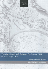
This is the handbook for the third annual Victorian Museums & Galleries Conference held in Warrnambool. The conference was run in conjunction with Flagstaff Hill Maritime Village which was celebrating its 40th anniversary. Warrnambool Art Gallery was one of the sponsors of the conference. This handbook is of interest as it tells us of the activities and speakers at a conference which was held in Warrnambool in 2014 and which highlights particularly Flagstaff Hill Maritime Village and the Warrnambool Art Gallery. This is a paper back booklet of 16 pages. It is the Conference Handbook of the Victorian Museums & Galleries Conference 2014 which was held at Warrnambool in April 2014. The pages contain printed material, advertisements, the conference program and information on the conference presenters. The cover has a white background with a map of Warrnambool Bay and town (Stanley 1870) on the front cover and an advertisement on the back cover.Front Cover: Museums Australia, Victoria, Victorian Museums & Galleries Conference 2014, Warrnambool 3-4 April, Museums Australia (Victoria), Conference Handbookvictorian museums & galleries conference. -
 Warrnambool and District Historical Society Inc.
Book, Historic Places of South West Victoria
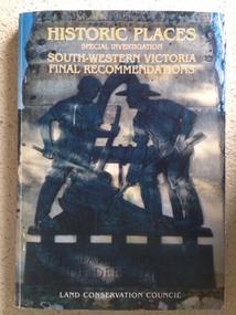
This is the third in a series of booklets produced by the Land Conservation Council in 1997 (176 pages). Booklets One and Two (1996) contained A Descriptive Report and Proposed Recommendations. The Final Recommendations include information on processes for protection of historic places, lists of significant places in the south-western region and aboriginal historic places. Attached inside the back cover are two maps showing the location of the significant places.This is a useful book as it lists the declared historic sites in the region and researchers will find the information helpful. This is a soft-cover book with a multi-coloured cover featuring a photograph of the Pioneers Memorial, Deep Lead. It has a red-coloured spine and back cover.Front Cover – Historic Places - Special Investigation - South-Western Victoria - Final Recommendations – Land Conservation Council Spine – Historic Places – South-Western Victoria – Final Recommendations – Land Conservation Council Back Cover – Historic Places, Final Rec., code used for retail sales warrnambool -
 Warrnambool and District Historical Society Inc.
Booklet, Love sweetens truth, 1880s
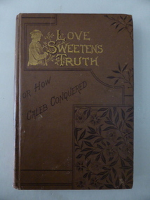
This book was a prize awarded to Miss Middleton, a pupil at Ormiston House College, East Melbourne in 1887. The Principals of the school were the Misses Singleton and their father, Dr John Singleton was a practising doctor in Warrnambool from 1860 to 1865. He had an important influence on Warrnambool, establishing several Total Abstinence Societies and campaigning for improved health conditions for pastoral workers in the district and the aborigines at Framlingham. In Melbourne Dr Singleton and his wife worked tirelessly for the underprivileged. He established many institutions for the less fortunate, including the Prisoners’ Aid Society, the Children’s Hospital, lending libraries, cottages for widows, shelters for homeless men and women, a society for the protection of animals and the Collingwood Free Medical Dispensary. He died in 1891 at Ormiston House, his daughters’ school and home. It is not known which of the Singleton daughters ran the school and no information has been found on Miss Middleton. This book is of considerable interest as it has a close connection to Dr John Singleton, important not only in the social history of Melbourne but also in the history of Warrnambool. This is a hard cover book of 160 pages with 16 pages at the back of the book of advertisements for other books published by the Religious Tract Society. The cover is brown with a sketch of a young man and lettering in gold and an ornamental floral pattern on the front cover. The gold lettering and the ornamental floral pattern are also on the spine. The book has 13 chapters with ornamental scrolls and initials at the beginning and end of each chapter. There are also some full page black and white sketches in the book, with the one at the front of the book covered by a piece of tissue paper. The book plate at the front of the book is white with a gold border pasted onto the page and handwritten details have been added in black ink. The book is a little scuffed at the edges of the cover. ‘Ormiston House College, East Melbourne, Principals, The Misses Singleton, Prize for Writing and Maps in Upper Third Class Awarded to Miss Middleton, Christmas 1887.’ dr john singleton, ormiston house, history of warrnambool -
 Warrnambool and District Historical Society Inc.
Document, Warrnambool Cemetery Walk 2000, 2000
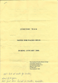
The Warrnambool Family History Group was established in 1980. It has been running Warrnambool cemetery tours for a great number of years with the late Marie Boyce being a prominent organizer of these tours. The tours are usually held in January and on Anzac Day and over recent years have concentrated on a theme to provide information on a certain group of people (eg Mayors, war heroes). These sheets are a good example of the graves visited during the Warrnambool Cemetery tours and the information given on these people. These are two yellow A4 sheets typed back and front with information on people buries in the Warrnambool Cemetery and a sketch map of the Warrnambool Cemetery. The typed material has been annotated with handwritten notes (blue biro) by a participant on one of the walking tours.Front page: ‘Cemetery Walk, Notes for Walks Held During January 2000. Warrnambool Family History Group (Australian Institute of Genealogical Studies Inc) Reg. No. A0027436X, P.O. Box 607, Warrnambool 3260 (sic)’warrnambool family history group, warrnambool cemetery tours -
 Warrnambool and District Historical Society Inc.
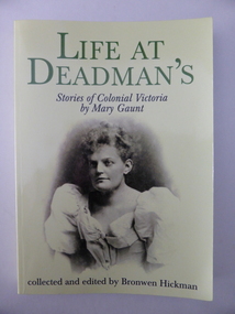
Book, Life of deadmann - Colonial Vic. Mary Gaunt, 2001
This collection of short stories by Mary Gaunt has been edited and published by Bronwen Hickman. Mary Gaunt (1861-1942) was a writer of novels, travel books, short stories and other articles. She was known internationally for her writings in the late 19th century and early 20th century. Born in Chiltern, Victoria, she was the first woman to study at Melbourne University, travelled extensively in West Africa and China in areas rarely visited by white women and published 26 books. From 1894 to 1900 Mary Gaunt lived in Warrnambool where her husband, Hubert Lindsay Miller, was a local doctor. Some of her writings were produced while she was in Warrnambool and some have local content. This book, although a modern reprint, is important as the only collection of the short stories of the internationally-known author, Mary Gaunt that we have in our collection. Mary Gaunt not only lived and wrote in Warrnambool for some years but also used local places, people and events in her writings. One of the stories in ‘Life at Deadman’s’ (‘The Humbling of Sergeant Mahone’) is based on the events in the late 19th century when whisky was being made illegallyin the Nirranda district. Mary Gaunt apparently had met the real main character in this saga. This is a soft cover book of 178 pages. The cover is yellow with an image in sepia tones of Mary Gaunt. The lettering on the front cover and on the spine is green and black. The back cover contains critical comments on Mary Gaunt’s work and information on the editor. The book has a map, an introduction, a list of the sources of the stories, twelve short stories, a list of works by Mary Gaunt and a note on the author by the editor. ‘With Good Wishes Bronwen Hickman’ mary gaunt, dr h.l.miller, whiskey stills in the warrnambool district (19th century), history of warrnambool, australian women writers -
 Warrnambool and District Historical Society Inc.
Book, Warrnambool Standard Almanac 1926, 1926
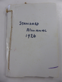
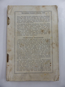
This booklet was given to subscribers to the Warrnambool Standard newspaper as an almanac for the year 1926. Warrnambool Standard Almanacs were produced from 1875 to 1930. They contain much local information on Warrnambool and district about the businesses, government officials, banks, churches, schools, harbour management, societies and organizations etc. The Warrnambool Standard newspaper was established in 1872 and continues to this day. This booklet is of high significance as it contains much valuable information about Warrnambool and district for the year 1926. It is a very important research tool for those studying and writing the history of Warrnambool and district. This is a booklet of 112 pages. Some of the advertisements at the front and the back are missing. The cover is also missing and has been replaced by a piece of white cardboard affixed with string. The cover has handwritten black printing. The booklet has a fold-out sheet of a map of Warrnambool, several photographs in blue and brown tonings and other illustrations. warrnambool standard newspaper, history of warrnambool, standard almanac 1926 -
 Warrnambool and District Historical Society Inc.
Book, Warrnambool Standard Almanac 1929, 1929
This booklet was given to subscribers to the Warrnambool Standard newspaper as an almanac for the year 1929. Warrnambool Standard Almanacs were produced annually from 1875 to 1930. They contain much local information on Warrnambool and district about the businesses, government officials, banks, churches, schools, harbour management, societies and organizations etc. The Warrnambool Standard newspaper was established in 1872 and continues to this day. This booklet is of high significance as it contains much valuable information on Warrnambool and district for the year 1929. It is an important resource tool for those studying and writing the history of Warrnambool and district. This is a booklet of 100 pages. The cover and several pages at the back and the front of the booklet are missing. The booklet is bound with metal staples. The booklet has a fold-out map of Warrnambool printed in green, several photographs printed in black and white and others in brown and blue tonings and other illustrations. The booklet is splotched and stained throughout. warrnambool standard newspaper, standard almanac 1929 -
 Kiewa Valley Historical Society
Report - Alpine Study Area Volume 2 Maps, Land Conservation Council, 1970s
The Victorian Environmental Assessment Council and the former Environment Conservation Council (ECC) and Land Conservation Council (LCC) have completed 36 land use investigations over more than 35 years, including 27 regional reviews. They provide a framework for use of Public Land in Victoria. The Land Conservation Council was established by the Land Conservation Act 1970.These maps provide an assessment of the Alpine area at the time the maps were created. Some of the topics eg. Rainfall and water resources may change over the years thus providing a comparative analysis. Others may provide information for future development such as mineral exploration, building of a dam / tunnel etc.Blue box shaped folder containing 9 of 10 Maps of the Alpine Study Area produced by the Land Conservation Council. Maps include 1. Public land and descriptive blocks. 2. Physiography. 3. Topography. 4. Geology (missing). 5. Rainfall and water resources. 6. Vegetation 7. Land systems. 8. Recreation. 9. Primary production. 10. Minerals Ex library item. Stamped in red "Discarded From Stock / Swan Hill Regional Libraryalpine area, maps of alpine area, land conservation council -
 Kiewa Valley Historical Society
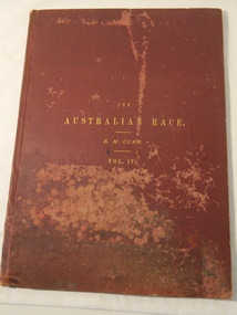
Book & Map - Australian Aborigines' Language, The Australian Race Vol. IV by Edward M. Curr, 1887
This book is the fourth volume of the Australian Race which was printed by the Government printer. The other 3 volumes cover the origin, languages, customs, place of landing in Australia, and the routes by which it spread itself over that continent. This book and map indicate an interest in the Aboriginal Race of Australia during the late 1880s.A local family owned this book indicating an interest in the Aborigines of Australia. The languages of Aboriginal tribes throughout Australia can be compared with those tribes of the Kiewa Valley adding (confirming) to the information sourced from alternative sources.Large thin brownish book with gold embossed title on front cover. 45 pages with blank cover pages. Each page has 8 columns giving the aboriginal word of each tribe giving a comparitive vocabulary of selected English words. Fold out map inserted in flap at rear. It is a map of Continental Australia, showing the routes by which the Aboriginal race spread itself throughout the continent.aborigines; first people of australia; aboriginal language; aboriginal tribes; kiewa valley -
 Kiewa Valley Historical Society
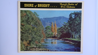
Brochure - Shire of Bright, Shire of Bright Tourist Centre of N.E. Victoria, Pre 1966
Bright and the surrounding towns were developing a large tourism industry which the Shire of Bright continues to promote, encouraging tourists to visit throughout the year. This high quality brochure has magnificent photos with a map showing the area and the distance (in miles) from the centre - the township of Bright.This brochure is promoting the Shire of Bright encouraging tourism in the area. This is important for the Shire as tourism is the main industry for the Shire. It is interesting to see how tourism has changed (or not) in the area.14 pages on glossy paper including colored and black and white photos. The front cover has the title at the top with yellow print on black background. Below the title is a large colored photo of a river, autumn trees and mountain. The back cover is a large colored photo of a man amongst the snow gums in the snow. The towns covered are Bright, Wandiligong, Eurobin, Mt Buffalo, McKay Creek Power Station, The Kiewa Hydro Electric Scheme, Mt Beauty, Kiewa, Bogong including tourist destinations in these areas and their surrounds.tourism; mt beauty; the kiewa valley; bright shire -
 Kiewa Valley Historical Society
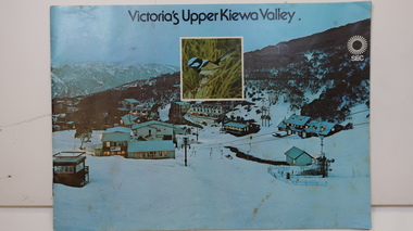
Booklet - SEC x2, 1. Victoria's Kiewa Valley 2. Victoria's Upper Kiewa Valley, No. 2 is dated October 1978
The State Electricity Commission of Victoria built the Kiewa Hydro Electric Scheme and was keen to promote tourism in the area. The booklet includes Facilities, Falls Creek Ski Resort, the Kiewa Works Area, the Three Floras of Bogong, the Geology of the Kiewa area, the Bird and Animal life of Bogong and the Kiewa Hydro Electric Scheme. The colored photos and the map on the back appeal to the reader/tourist.The SECV promoted tourism in the Kiewa Valley especially the area of the Kiewa Hydro Electric Scheme. This booklet is attractive and informative with a lot of detail. This proved to be the early stages of tourism in the area in what is now a very popular tourist destination and the main industry for the Upper Kiewa Valley.Blue cover with photo of Falls Creek at night. Title in black print at the centre top under which is an insert photo of a blue wren and SEC logo in white towards the top far right. Back cover is light green with a tourist map of the area. The text is complimented with brightly colored photos throughout.state electricity commission of victoria; kiewa hydro electric scheme; tourism; bogong; flora; fauna; geology; -
 Kiewa Valley Historical Society
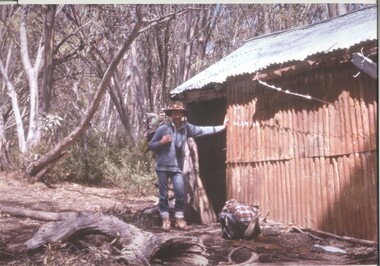
Photograph - Coloured Photographs x 5 - Bogong High Plains, January 1969 and c1970
Bivouac Hut was built in 1935 on the Northern end of Mt. Bogong, on the Staircase Spur, about halfway to the summit. It was funded by Cleve Cole and he arranged for Walter Maddison to build it. Cleve Cole dedicated his life to the mountains and wanted to make them safer to visit - more huts and improved maps, pole lines and tracks. He perished in the winter of 1936 after attempting to make the first winter crossing from Mt. Hotham to Mt. Bogong on skis. The two others with him, Howard Michell and Mick Hull survived. The weather conditions were extreme at the time and having made the summit of Mt. Bogong they then became disorientated in the blizzard and came down the southern end of Bogong instead of the northern end . Howard Michell made it out to Glen Valley, a small mining town, to get help. Mick and Cleve were carried out on rough bush stretchers and Cleve died a few hours later. The Summit Hut was funded by Howard Michell and built in the 1940's. It was deliberately burnt down in the early 1980's. Bivouac hut was rebuilt in the 1980's.These photographs are of historical significance. Both huts were funded by experienced bushwalkers to provide shelter from the weather and so make walking and skiing in the area safer. They are both now gone with Bivouac being replaced with a more modern structure but there is nothing left of the Summit Hut. 5 coloured photographs, A4 in size, 4 near the summit of Mt. Bogong (Three of the Summit Hut) and one of Bivouac Hut on the Staircase Spur leading up to the summit.1. Hand written in ink on back of Photo - "Mt. Bogong Sep. 1976' - all underlined. Below this "Staircase Spur Hut The bloke in the hat me (David Jones)". 2. Handwritten in ink on back of photo - "Mt. Bogong winter 1970" (underlined). Underneathe "Same old Hut". 3. Handwritten in ink "Mt. Bogong Jan. 1969" (Underlined) Underneath "Tawonga Saddle looking towards the Summit". 4.Handwritten in ink back of photo "Mt. Bogong Jan. 1969" (underlined) Old hut near Summit, since removed, at the top of Staircase Spur. View looking out over Kiewa Valley." 5.Hand written on back of photo "Mt. Bogong Jan. 1969" (Underlined). Underneath - " Same old Hut (Staircase Spur) early morning".mt. bogong, summit hut, bivouac hut -
 Kiewa Valley Historical Society
Maps of Victoria
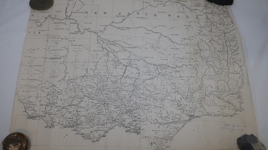
Three maps: copies from the 19th century. 1. Handwritten 'Dept of Lands & Survey 1876'. 2. Map of the Ovens & Murray District, Victoria with handwritten 'F.H. Hiscock & Co's, New Victoria Countries Atlas 1874'. 3. Map of the Murray and Gipps Land Distr' with handwritten: "Baillieu's County Atlas of Victoria 1866'.maps of victoria, 19th century, oven and murray district of victoria -
 Kiewa Valley Historical Society
Maps, Unknown
... sides have advertising and information for tourists./ 4/-. Maps ...There are 2 maps: 1. Broadbent's Makers of Maps since 1896, No. 323 Across the Alps/Official Copyright Map./ The cover is blue, green and orange with advertising for Ólympic' and 'Bosch' and there is further advertising on the fold out covers/ 2/-. 2. Robinson's Kiewa Hydro-Electric Scheme & Hotham Heights Map No. 613, with Insets of: Bright, Mt Beauty, Falls Creek Ski Village, Hotham Heights Ski Village/ the cover is blue, green and orange with image of skier, hydro tower and locality map./Other fold out sides have advertising and information for tourists./ 4/-.maps, tourism, kiewa hydro electric scheme, victorian alps, skiing -
 Kiewa Valley Historical Society
Paper Sheet - Shire of Bright Plans
Oblong sheet of paper - bright yellow (or orange). Black typed writing and subdivision maps of the Kiewa Valley Planning Scheme in the Shire of Bright. Circa 1980s2 pages of maps and scriptshire of bright, maps, kiewa valley -
 Kiewa Valley Historical Society
Maps - Bogong x2, Tawonga, Omeo, Dargo, Victoria and others, 1. Bogong Alpine Area; 2. Bogong 8324; 3. Tawonga Topographical; 4. Omeo 8433; 5. Dargo 8323; 6. Victoria State
1. Bogong Alpine Area (outdoor Leisure Map. survey & Mapping Victoria, Government of Victoria, Edition 2, reprinted 1991 with an image of Mt. Feathertop on the front. Information for tourist in the Alpine National Park: Bogong Area. Including: recreational activities, history, weather and vegetation and a list of walks together with locality maps and photographs. The front cover has an image of Mt Feathertop against a blue sky with yellow writing 'Bogong Alpine Area', there is a yellow triangular block on the right hand top corner with black writing 'Outdoor Leisure Map. On the bottom edge is a block of yellow with black writing 'Survey & Mapping Victoria' and a light green map of Victoria with 'VICMSP' printed in white. 2. 8324 Bogong Victoria, Edition 1, Commonwealth of Australia 1981. A topographical Map: 1:100,000 scale (1 cm to 1 KM). Map has a red cover with white writing together with a white block and black writing and a map insert. 3. Tawonga Topographical Map - Forests Commission Victoria, / revised 5/9/77, DEG No. 68-G/399. A Tawonga 803 folded map in a beige colour with the back blank. 4. Omeo 8433 Victoria, Edition 1, Department of Natural Resources. The map has a red and white cover with black writing and a simple map of Australia at the bottom. 5. 8323 Dargo, Edition 1, Commonwealth of Australia. A red and white cover with a map insert. 6. Victoria State Map, Hema Maps, 2002. Hema Maps, State Map, colourful cover with a map of Australia and four tourism photographs. Scale 1: 850,000 An inscription handwritten in blue pen "Trappers Gap to Mitta Mitta 1" to 1 mile". There are some pen markings and notations of tracks.maps, bogong, omeo, tawonga, dargo, victoria, bogong alpine area -
 Kiewa Valley Historical Society
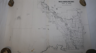
Map - Mullindolingong
Land owners of land in the Kiewa Valley in 1928The Kiewa Valley was farming country with families settling in the area prior to 1928 Two sheets the same: (one old with paper joined together and the other is a copy without any joins. 21 6 1928 dated Map of Mullindolingong / County of Bogong showing land owners along the Kiewa River and beyond.Produced by the Department of Lands and Survey, Melbournemullindolingong, kiewa valley, land owners, families of the kiewa valley -
 Kiewa Valley Historical Society
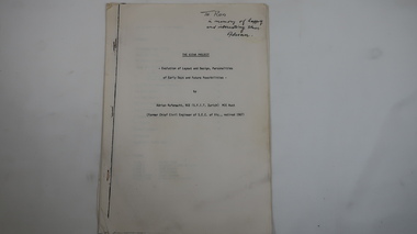
Memoir - Adrian Rufenacht, The Kiewa Project
Adrian Rufenacht, BCE (S.F.I.T. Zurich) MIE Aust. former Chief Civil Engineer of the State Electricity Commission of Victoria, retired 1967. Insight into the Kiewa Hydro Electric Scheme.First hand knowledge of the history of the Kewa Hydro Electric Scheme.40 pages stapled with 4 staples. The Kiewa Hydro Electric Scheme by Adrian Rufenacht, former civil engineer of SECV. Includes maps.On the front page - handwritten: 'To Ron / in memory of happy / and interesting times. / Adrianadrian rufenacht, khes, kiewa project, construction, secv -
 Kiewa Valley Historical Society
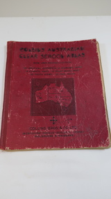
Book - Educational - School Atlas, Collins' Australian Clear School Atlas
Australian schools used Atlases to teach students geography and the nationalities of countries worldwide.Clare Roper was a resident of the Kiewa Valley. This atlas is of interest because it is circa 1950s and shows the world at this time.Thick red cardboard cover with black print and map of Australia on cover. It includes coloured maps of countries, black & white photos and an index at the back. On the inside of the cover both front and back it has black and white maps. There are 30 pages and it is bound. Circa 1950sCover page: handwritten "Margaret Tulloh / C. Roper / Margaret Tulloh / M.L.C. Some pages have been marked with pencilaustralian school atlas, clare roper -
 Kiewa Valley Historical Society
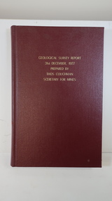
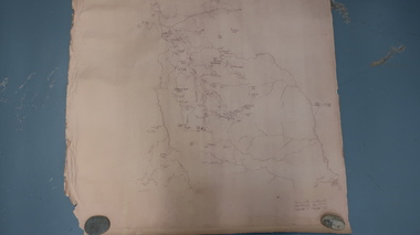
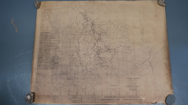
Book - Geographical Survey, Geographical Survey Report 31st Dec. 1977 prepared by Thos. Couchman Secretary for Mines
Office of Mines published progressive reports on the Geological Survey of parts of Victoria.This book includes a chapter on 'Dargo and Bogong' Pages 96 - 117 and includes a fold out map of this area. These pages show heavy use.Hard deep red cover with gold printed title located at the centre top. Bound with spine blank. 217 pages. Date 1878 First chapter and some pages have pencil marks including page 97.geological survey 1878, dargo, bogong -
 Kiewa Valley Historical Society
Map - Bogong High Plains
Bogong high Plains showing mountains, places, roads and riversHistorical changes of infrastructure on the Bogong High PlainsBogong High Plains, hand written and 'copied with considerable simplification from F.C.V. (Falls Creek V.?) 'Feathetop' L 'Tawonga'. Paper is yellowed, writing is brown.bogong high plains map -
 Kiewa Valley Historical Society
Maps - Tawonga and Feathertop
Plan of Tawonga showing roads etc, rivers, use of land in 1968 and of Feathertop in 1969.Historical use of land in Tawonga and Feathertop.1. Topographical Map - Tawonga 803 Forests Commission of Victoria 1968. Cream paper with black print. Legend: Roads, tracks etc, rivers, Parishes and use of land. 2. Feathertop 813. 1969tawonga map 1968, tawonga parishes, feathertop map 1969 -
 Kiewa Valley Historical Society
Map - Kiewa Scheme General Plan
Existing and possible future roads are numbered and named 1 - 45. The plan is based on an aerial photos taken March 1945. It includes revisions up to 1951. Signed by H.H.C. Williams, construction engineer. Mountains, rivers, roads and SECV places are named, also SECV infrastructure and construction eg. workers camps, Power stations.Significant for the information re the Kiewa Hydro Electric Scheme's development.Yellowed paper with brown print. Kiewa Scheme general plan showing its development. A lot of information is recorded. Note: Dyeline print was used which causes fading when exposed to light. Handwritten: 'Bob Duncan'bob duncan, kiewa hydro electric scheme, secv, khes development -
 Kiewa Valley Historical Society
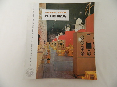
Booklet - S.E.C.V. x2, Power from Kiewa
The State Electricity Commission of Victoria constructed the Kiewa Hydro Electric Scheme. Their public relations employees published booklets to promote the Scheme and the area. In this booklet there are photos of some of the major work constructions with an explanation of how they work and their purpose, a map of the Scheme and an article and photos of tourist facilities and activities that are available.This booklet promotes the Kiewa Hydro Electric Scheme and tourism indicating that tourism was recognised as a new industry for the area. The photos give a pictorial history of the area eg. skiing using the Summit T-bar lift and includes the facilities available at the time. The explanation of the Kiewa Hydro Electric Scheme is a basic resource for students interested in Hydro power.Slim booklet with photo of McKay Creek Power Station on the front cover and the title in brown and black at the top. Printed along the spine is State Electricity Commission of Victoria.state electricity commission of victoria. kiewa hydro electric scheme. tourism. t-bar ski tow. falls creek -
 Kiewa Valley Historical Society
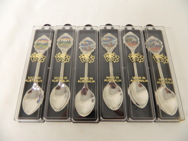
Spoons - Souvenir, Mt Beauty x6
Souvenirs are sold to tourists as a moment of their visit to Mt BeautyMt Beauty is a tourist town6 spoons - 2 of each with a different picture. Silver spoon in a plastic case. The case has a black side with a ring at the top and 2 small pieces that jut out from inside to hold the spoon. The clear front cover fits on and has gold embossing. The stem of the spoon is embossed with lines on the front. At the end there is a circular coloured picture with 'Mt Beauty' below surrounded by embossed decoration.Cover: Map of Auistralia with ASM along the W.A. side / Made in / Australia Spoon: top of handle - Mt Beauty. back of handle - embossed kangaroo. back of stem - 'Swann and Hudson Made in Australiamt beauty. souvenir. silver spoon. tourism. swann and hudson -
 Kiewa Valley Historical Society
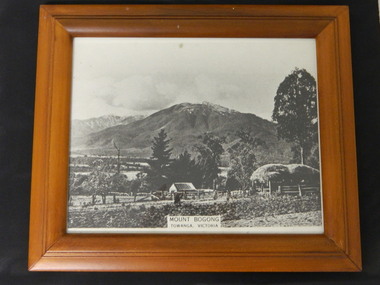
Photo - Mt Bogong, Towanga, Possibly early 1900s
Towanga & Mt Bogong. Mt Bogong is actually the mountain on the left at the back. Early maps spelt Tawonga differently to the current day spelling 'Tawonga'. The haystack and fence indicate that the photo may have been taken at the turn of the century. The exotic trees are not very old.This seems to be an early photo of Tawonga showing older style fencing and haystack and vegetation in the area.Black and white photo with title at the bottom middle - "Mt Bogong / Towanga (sic), Victoria Modern light brown wooden frame with black cardboard back triangular hook and black cardboard stand attached. Photo covered with clear glass.Sticker on back of frame "67480 Eng Walnut / 49426 / Made In Thailandtowanga. tawonga. mt bogong. kiewa valley. -
 Kiewa Valley Historical Society
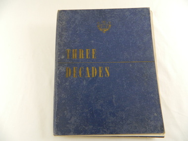
Book - Historical - SECV x3, Three Decades. The Story of the State Electricity Commission of Victoria from its Inception to December 1948, First Published March 1949
At the time of writing this book The State Electricity Commission of Victoria had been in existence for 30 years. This book tells something of its progress and achievements during that period. It includes brown coal and water power. The Commission was to develop and use these natural resources through the expertise and experience of the Commissioners, its staff and employees. Historical: Chapter 5 "The War Years - and Kiewa." describes the early stages of the Kiewa Hydro Electric Scheme. Photos, map and diagrams of the Kiewa Scheme are also included. Hard cover blue bound book with the SECV insignia and the title "Three Decades" both in gold on the front cover. Book includes coloured and black and white photos.Handwritten inside front cover: "Bob Burnett". Title page: hand written in print and crossed out: "L.D.Miller / Tawonga". Not crossed out - "(Cheryl)"state electricity commission of victoria. kiewa hydro electric scheme. bogong high plains. pretty valley. kiewa valley. -
 Kiewa Valley Historical Society
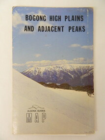
Map - Bogong High Plains & Adjacent Peaks x2, 1976
This map was produced as a result of the 'pressure from walkers' who are interested in climbing the accessible peaks on the Bogong High Plains. Places, huts and rivers are named and indexed. Contours are not given. Heights of mountains are in metres.The Bogong High Plains is a popular walking area and a National Park. This map identifies the mountains and peaks in the area at the time of publication. Some of the huts have since been destroyed by fire and Mt Niggerhead has since been renamed to Jaithmathang.Blue and white cardboard folded in half containing a folded black and white map of Bogong High Plains and Adjacent Peaks with index.bogong high plains. mountains. bushwalkers. walking. map. national park. recreation. cycling. tourism -
 Kiewa Valley Historical Society
Parish Maps - Kiewa Valley
The Parish Maps show how the Counties were divided into allotments for buyers. On one the original owners are named and the sizes of their properties given. The reference numbers enable individuals research the history of the property. The other is on a smaller scale giving only the allotment numbers. The map with the names gives information on the early settlers of the Kiewa Valley. They show how the Kiewa Valley was divided up into allotments for town dwellers and farmers and enables further research.Two copies of Parish Maps of the towns in the Kiewa Valley. One gives the original owners and the other the reference numbers of the allotments.kiewa valley. parish maps. land owners -
 Kiewa Valley Historical Society
Map - Topographical, Ski Club of Victoria Bogong High Plains and Adjacent Peaks, Early 1930's
This map has been in the Ryder family for approx. 70 years. Probably used when bush walking and skiing in the early days on the Bogong High Plains. The Ryder family are farmers in the Kiewa Valley and were involved in taking their cattle up to the Bogong High Plains where they had a lease. The State Electricity Commission of Victoria constructed the Kiewa Hydro Electric Scheme opening up the area during the 1940's and 1950's. This type of map is an early one, used by people in the Kiewa Valley and possibly by surveyors prior to construction.The map is an early topographic map used by farmers living in the Kiewa Valley. It is historically significant as these people were involved in taking cattle up to the High Plains during summer and may have been used for bush walking and skiing.This is a sepia coloured paper map which was originally printed copyright registered. It was revised in 20/6.33/4.4.37/8.4.40/24.8.43/19/6/54. It shows roads / tracks / snow poles / snow pole numbers (27) / Snow pole spacing (3 chains. 66 yards) approximately 27 poles to the mile / height above sea level in feet - 5280. Water courses not definitely located etc.Rocky Valley Dam (Kiewa Hydro Electric Scheme) has been drawn on the map by hand with a biro. There is a wooden rod at the top of the map.topographic map; kiewa valley; ryder family; high plains of victoria