Showing 9124 items
matching a l
-
 Wodonga & District Historical Society Inc
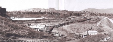
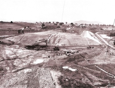
Album - Hume Reservoir Australia Album - General view of earth embankment in Victoria, October 1924, 1927
This set of photos is from a leather bound album bearing the inscription "HUME RESERVOIR AUSTRALIA" plus 'The Rt. Hon. L. C. M. S. Amery, P. C., M .P.' all inscribed in gold. It was presented to The Rt. Hon. L. C. M. S. Amery, P. C., M. P, Secretary of State for Dominion Affairs on the occasion of his visit to the Hume Reservoir on 2nd November 1927. This album is of local and national significance as it documents the planning and development of the Hume Reservoir up to 1927. It was the largest water reservoir in the British Empire. The album records the pioneering engineering work that went into its construction.DEPARTMENT OF PUBLIC WORKS, N.S.W. RIVER MURRAY WATERS SCHEME. HUME RESERVOIR. 17. General view of earth embankment in Victoria. New South Wales section of work and Township beyond. October 1924.hume reservoir australia, river murray waters scheme, hume reservoir construction -
 Wodonga & District Historical Society Inc
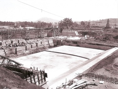
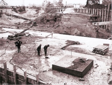
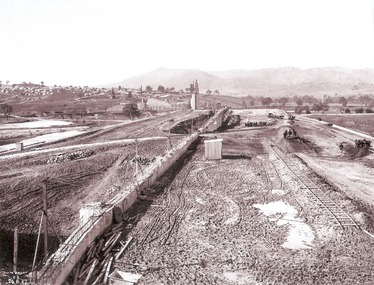
Album - Hume Reservoir Australia Album - Stilling pool opposite outlet section of dam, December 1925, 1927
This set of photos is from a leather bound album bearing the inscription "HUME RESERVOIR AUSTRALIA" plus 'The Rt. Hon. L. C. M. S. Amery, P. C., M .P.' all inscribed in gold. It was presented to The Rt. Hon. L. C. M. S. Amery, P. C., M. P, Secretary of State for Dominion Affairs on the occasion of his visit to the Hume Reservoir on 2nd November 1927. This album is of local and national significance as it documents the planning and development of the Hume Reservoir up to 1927. It was the largest water reservoir in the British Empire. The album records the pioneering engineering work that went into its construction.DEPARTMENT OF PUBLIC WORKS, N.S.W. RIVER MURRAY WATERS SCHEME. HUME RESERVOIR. 18. Stilling pool opposite outlet section of dam. New South Wales. December 1925 A stilling pool is a structure at the downstream side of a dam, designed to take away some of the energy from overtopping water flowing down the spillway, to reduce the risk of erosion of the ground near the dam and the dam itself.hume reservoir australia, river murray waters scheme, hume reservoir construction -
 Wodonga & District Historical Society Inc
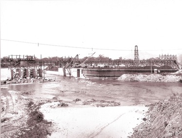
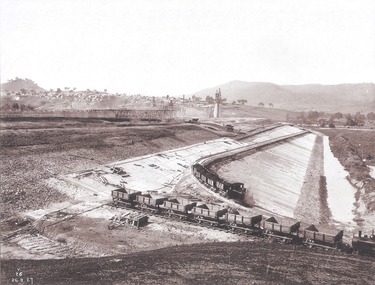
Album - Hume Reservoir Australia Album - Driving first row of piles for coffer dam across the river, December 1925, 1927
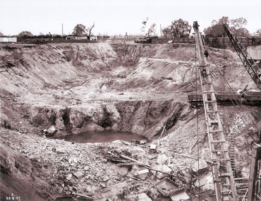
This set of photos is from a leather bound album bearing the inscription "HUME RESERVOIR AUSTRALIA" plus 'The Rt. Hon. L. C. M. S. Amery, P. C., M .P.' all inscribed in gold. It was presented to The Rt. Hon. L. C. M. S. Amery, P. C., M. P, Secretary of State for Dominion Affairs on the occasion of his visit to the Hume Reservoir on 2nd November 1927. This album is of local and national significance as it documents the planning and development of the Hume Reservoir up to 1927. It was the largest water reservoir in the British Empire. The album records the pioneering engineering work that went into its construction.DEPARTMENT OF PUBLIC WORKS, N.S.W. RIVER MURRAY WATERS SCHEME. HUME RESERVOIR. 19. Driving first row of piles for coffer dam across the river. New South Wales. December 1925. Cofferdams are temporary structures used where construction is being carried out in areas submerged in water. They are most commonly used to facilitate the construction or repair of dams, piers and bridges. To divert the river, a Coffer Dam was built across the old bed above and below the Dam site and tying into the end of the concrete wall built inside the levee bank. This completely surrounded the remainder of the site of the Dam and south wing wall, including an area of 12½ acres. hume reservoir australia, river murray waters scheme, hume reservoir construction -
 Wodonga & District Historical Society Inc
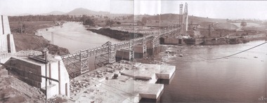
Album - Hume Reservoir Australia Album - Section of completed coffer dam, January 1927, 1927
This set of photos is from a leather bound album bearing the inscription "HUME RESERVOIR AUSTRALIA" plus 'The Rt. Hon. L. C. M. S. Amery, P. C., M .P.' all inscribed in gold. It was presented to The Rt. Hon. L. C. M. S. Amery, P. C., M. P, Secretary of State for Dominion Affairs on the occasion of his visit to the Hume Reservoir on 2nd November 1927. This album is of local and national significance as it documents the planning and development of the Hume Reservoir up to 1927. It was the largest water reservoir in the British Empire. The album records the pioneering engineering work that went into its construction.DEPARTMENT OF PUBLIC WORKS, N.S.W. RIVER MURRAY WATERS SCHEME. HUME RESERVOIR. 20. Section of completed coffer dam with river diverted over the concrete foundations of dam that were placed during the first stage of operations. New South Wales. January 1927. Cofferdams are temporary structures used where construction is being carried out in areas submerged in water. They are most commonly used to facilitate the construction or repair of dams, piers and bridges. To divert the river, a Coffer Dam was built across the old bed above and below the Dam site and tying into the end of the concrete wall built inside the levee bank. This completely surrounded the remainder of the site of the Dam and south wing wall, including an area of 12½ acres. hume reservoir australia, river murray waters scheme, hume reservoir construction -
 Wodonga & District Historical Society Inc
Album - Hume Reservoir Australia Album - Excavations for foundations inside coffer dam, January 1927, 1927
This set of photos is from a leather bound album bearing the inscription "HUME RESERVOIR AUSTRALIA" plus 'The Rt. Hon. L. C. M. S. Amery, P. C., M .P.' all inscribed in gold. It was presented to The Rt. Hon. L. C. M. S. Amery, P. C., M. P, Secretary of State for Dominion Affairs on the occasion of his visit to the Hume Reservoir on 2nd November 1927. This album is of local and national significance as it documents the planning and development of the Hume Reservoir up to 1927. It was the largest water reservoir in the British Empire. The album records the pioneering engineering work that went into its construction.DEPARTMENT OF PUBLIC WORKS, N.S.W. RIVER MURRAY WATERS SCHEME. HUME RESERVOIR. 21. Excavations for foundations inside coffer dam. New South Wales. January 1927. Cofferdams are temporary structures used where construction is being carried out in areas submerged in water. They are most commonly used to facilitate the construction or repair of dams, piers and bridges. To divert the river, a Coffer Dam was built across the old bed above and below the Dam site and tying into the end of the concrete wall built inside the levee bank. This completely surrounded the remainder of the site of the Dam and south wing wall, including an area of 12½ acres. hume reservoir australia, river murray waters scheme, hume reservoir construction, coffer dam -
 Wodonga & District Historical Society Inc
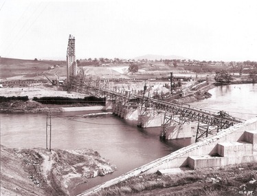
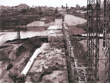
Album - Hume Reservoir Australia Album - General View of Works from New South Wales end, Looking Upstream, August 1927, 1927
This set of photos is from a leather bound album bearing the inscription "HUME RESERVOIR AUSTRALIA" plus 'The Rt. Hon. L. C. M. S. Amery, P. C., M .P.' all inscribed in gold. It was presented to The Rt. Hon. L. C. M. S. Amery, P. C., M. P, Secretary of State for Dominion Affairs on the occasion of his visit to the Hume Reservoir on 2nd November 1927. This album is of local and national significance as it documents the planning and development of the Hume Reservoir up to 1927. It was the largest water reservoir in the British Empire. The album records the pioneering engineering work that went into its construction.DEPARTMENT OF PUBLIC WORKS, N.S.W. RIVER MURRAY WATERS SCHEME. HUME RESERVOIR. 22. General View of Works from New South Wales end, Looking Upstream. Features: At the left, part of the North Wing Wall, the highest part of which is 26 feet below its ultimate height. Below in the foreground is the portion of the dam where provision is to be made for hydro-electric generation. The tubes, three in number, 13 feet in diameter, will be laid on the level shown and an early start will be made in laying them. The level for the other four regulating outlets, 9 feet in diameter, together with a part of the spillway section of the dam, is underwater at this stage and it may be remarked that at one point, about half way across the channel where the water is now flowing, the concrete foundations are about 80 feet below the level of the water. The broken surface of the water is due to the large “plums” in the concrete. The still water in the right foreground is the stilling pool over the concrete floor of which there is now more than 20 feet of water and by means of which the discharge from the outlet pipes will be quelled. The trestlework on the upstream side of the dam carries the concrete belt conveyor. It extends from the concrete mixer house, which is out of the picture, behind the wing wall, along almost the entire length of the concrete portion of the dam. The concrete is discharged from the belt at any desired point by means of trippers, one of which may be seen over the second trestle. On the other side of the flowing water is the coffer dam. A channel 300 feet wide involving about 140,000 cubic yards of excavation and dug for the temporary diversion of the river as it is flowing now. To the right top of the view beyond the Coffer Dam is the earth embankment being thrown across the major part of the valley by the Victorian Constructing Authority. The Mitta Mitta River flows into the Murray at the far end of the reach of water on the left. August 1927.hume reservoir australia, river murray waters scheme, hume reservoir construction -
 Wodonga & District Historical Society Inc
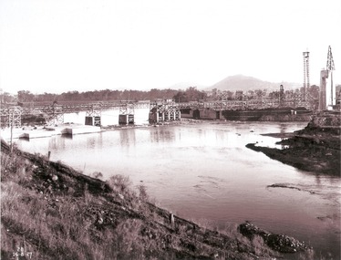
Album - Hume Reservoir Australia Album - General View of Works from New South Wales end, Looking Upstream, August 1927, 1927
This set of photos is from a leather bound album bearing the inscription "HUME RESERVOIR AUSTRALIA" plus 'The Rt. Hon. L. C. M. S. Amery, P. C., M .P.' all inscribed in gold. It was presented to The Rt. Hon. L. C. M. S. Amery, P. C., M. P, Secretary of State for Dominion Affairs on the occasion of his visit to the Hume Reservoir on 2nd November 1927. This album is of local and national significance as it documents the planning and development of the Hume Reservoir up to 1927. It was the largest water reservoir in the British Empire. The album records the pioneering engineering work that went into its construction.DEPARTMENT OF PUBLIC WORKS, N.S.W. RIVER MURRAY WATERS SCHEME. HUME RESERVOIR. 23. General view of works from the New South Wales end, looking downstream. The features are generally speaking the same as in the last view 22 (Record WHS 00716) in reverse.hume reservoir australia, river murray waters scheme, hume reservoir construction -
 Wodonga & District Historical Society Inc
Album - Hume Reservoir Australia Album - View looking upstream, August 1927, 1927
This set of photos is from a leather bound album bearing the inscription "HUME RESERVOIR AUSTRALIA" plus 'The Rt. Hon. L. C. M. S. Amery, P. C., M .P.' all inscribed in gold. It was presented to The Rt. Hon. L. C. M. S. Amery, P. C., M. P, Secretary of State for Dominion Affairs on the occasion of his visit to the Hume Reservoir on 2nd November 1927. This album is of local and national significance as it documents the planning and development of the Hume Reservoir up to 1927. It was the largest water reservoir in the British Empire. The album records the pioneering engineering work that went into its construction.DEPARTMENT OF PUBLIC WORKS, N.S.W. RIVER MURRAY WATERS SCHEME. HUME RESERVOIR. 24. Another view looking upstream. August 1927.hume reservoir australia, river murray waters scheme, hume reservoir construction -
 Wodonga & District Historical Society Inc
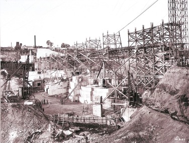
Album - Hume Reservoir Australia Album - Work proceeding inside the coffer dam, August 1927, 1927
This set of photos is from a leather bound album bearing the inscription "HUME RESERVOIR AUSTRALIA" plus 'The Rt. Hon. L. C. M. S. Amery, P. C., M .P.' all inscribed in gold. It was presented to The Rt. Hon. L. C. M. S. Amery, P. C., M. P, Secretary of State for Dominion Affairs on the occasion of his visit to the Hume Reservoir on 2nd November 1927. This album is of local and national significance as it documents the planning and development of the Hume Reservoir up to 1927. It was the largest water reservoir in the British Empire. The album records the pioneering engineering work that went into its construction.DEPARTMENT OF PUBLIC WORKS, N.S.W. RIVER MURRAY WATERS SCHEME. HUME RESERVOIR. 25. Work proceeding inside the Coffer Dam. This shows the curving downstream face of the Spillway section taking shape, the bottom edge being the line of the contraction joint between the wall and the energy dissipater which has still to be built. Note the steam navvy at the end of the bit of curved work ready to take out the foundations for the energy dissipater. The tall concrete pillar is a portion of the work at the intersection of the main and south wing walls which was built in advance of the rest of the work to accommodate the tail tower of the cableway. The Tail Tower for the first stages of the work stood on the ground. Part of it is seen erected on the pillar while part of it is still in its original position. To command the concreting of the pillar end of the south wing wall a twin hoist tower of steel construction was erected at the end of the belt conveyor. This hoist is 160 feet high. The belt conveyor will at a later stage be raised for the concreting of the upper portion of the dam and the trestles are now being built up for that purpose. A drag line excavator with a 2 cubic yard capacity bucket is at work near the tail tower on the foundations for the south wing wall. New South Wales, August 1927.hume reservoir australia, river murray waters scheme, hume reservoir construction -
 Wodonga & District Historical Society Inc
Album - Hume Reservoir Australia Album - Work proceeding inside the coffer dam (2), August 1927, 1927
This set of photos is from a leather bound album bearing the inscription "HUME RESERVOIR AUSTRALIA" plus 'The Rt. Hon. L. C. M. S. Amery, P. C., M .P.' all inscribed in gold. It was presented to The Rt. Hon. L. C. M. S. Amery, P. C., M. P, Secretary of State for Dominion Affairs on the occasion of his visit to the Hume Reservoir on 2nd November 1927. This album is of local and national significance as it documents the planning and development of the Hume Reservoir up to 1927. It was the largest water reservoir in the British Empire. The album records the pioneering engineering work that went into its construction.DEPARTMENT OF PUBLIC WORKS, N.S.W. RIVER MURRAY WATERS SCHEME. HUME RESERVOIR. 26. Work proceeding inside the coffer dam. This view was taken from the edge of the cut for the South Wing Wall foundations looking from the opposite direction to that of the preceding photograph, the curving downstream face of the main wall being seen beyond the steam navvy. This view shows the way in which the concrete paddocks are stepped and broken jointed vertically and horizontally. In the distance is the North Wing Wall and Power House stack beyond it. New South Wales, August 1927.hume reservoir australia, river murray waters scheme, hume reservoir construction -
 Wodonga & District Historical Society Inc
Album - Hume Reservoir Australia Album - Preparing a paddock for concrete. August 1927, 1927
This set of photos is from a leather bound album bearing the inscription "HUME RESERVOIR AUSTRALIA" plus 'The Rt. Hon. L. C. M. S. Amery, P. C., M .P.' all inscribed in gold. It was presented to The Rt. Hon. L. C. M. S. Amery, P. C., M. P, Secretary of State for Dominion Affairs on the occasion of his visit to the Hume Reservoir on 2nd November 1927. This album is of local and national significance as it documents the planning and development of the Hume Reservoir up to 1927. It was the largest water reservoir in the British Empire. The album records the pioneering engineering work that went into its construction.DEPARTMENT OF PUBLIC WORKS, N.S.W. RIVER MURRAY WATERS SCHEME. HUME RESERVOIR. 27. Preparing a Paddock for Concrete. Great care is taken in cleaning the surface of the concrete before placing the next layer. A hose applies a jet of water with a pressure of about 150 pounds to remove laitance and all dirt, which is swept off with brooms. (Laitance is the weak, milky or powdery layer of cement dust, lime and sand fines that appear on the surface of concrete. ) The square block of concrete in the foreground is poured at the same time as the concrete surrounding it and acts as a key for the next layer. Usually large granite “plums” or displacers weighing from 2 tons to 8 tons are used for this purpose and are placed in position by the cableway, but while the cableway is out of action the other method has been adopted. In this view may also be seen some of the timber piles and sheeting which form the inner side of the coffer dam. The outer side is formed of steel sheet piling. The space between the two lines of piles is 20 feet wide and is filled with earth after the steel and timber lines have been bound together by steel tie rods. New South Wales, August 1927.hume reservoir australia, river murray waters scheme, hume reservoir construction -
 Wodonga & District Historical Society Inc
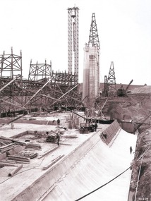
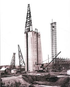
Album - Hume Reservoir Australia Album - Concrete pillar for tall tower, New South Wales, August 1927, 1927
This set of photos is from a leather bound album bearing the inscription "HUME RESERVOIR AUSTRALIA" plus 'The Rt. Hon. L. C. M. S. Amery, P. C., M .P.' all inscribed in gold. It was presented to The Rt. Hon. L. C. M. S. Amery, P. C., M. P, Secretary of State for Dominion Affairs on the occasion of his visit to the Hume Reservoir on 2nd November 1927. This album is of local and national significance as it documents the planning and development of the Hume Reservoir up to 1927. It was the largest water reservoir in the British Empire. The album records the pioneering engineering work that went into its construction.DEPARTMENT OF PUBLIC WORKS, N.S.W. RIVER MURRAY WATERS SCHEME. HUME RESERVOIR. 28. Concrete Pillar for Tail Tower. This shows the back and upstream side of the tower. The groove at the back is left for the reception of the concrete core wall of the earth embankment. The groove is being used at present as a hoist well, up and down which men and materials are conveyed in connection with the re-erection of the Tail Tower of the cableway. The pillar is 108 feet from the ground and is within 4 feet of its ultimate height. The foundation of this part at its deepest is 90 feet below the natural surface so that when the 80 feet tower and jury mast are in place the total height from foundation to top of mast will be about 300 feet. New South Wales, August 1927.hume reservoir australia, river murray waters scheme, hume reservoir construction -
 Wodonga & District Historical Society Inc
Album - Hume Reservoir Australia Album - View of concrete dam from top of tall tower pillar, August 1927, 1927
This set of photos is from a leather bound album bearing the inscription "HUME RESERVOIR AUSTRALIA" plus 'The Rt. Hon. L. C. M. S. Amery, P. C., M .P.' all inscribed in gold. It was presented to The Rt. Hon. L. C. M. S. Amery, P. C., M. P, Secretary of State for Dominion Affairs on the occasion of his visit to the Hume Reservoir on 2nd November 1927. This album is of local and national significance as it documents the planning and development of the Hume Reservoir up to 1927. It was the largest water reservoir in the British Empire. The album records the pioneering engineering work that went into its construction.DEPARTMENT OF PUBLIC WORKS, N.S.W. RIVER MURRAY WATERS SCHEME. HUME RESERVOIR. 29. View from Top of Tail Tower Pillar - Concrete Dam. This was taken from the top of the Tower described in the preceding photograph looking towards New South Wales. (WHS 00722) First is the part of the spillway being built inside the Coffer Dam, then over the Coffer Dam the submerged portion of the Spillway and outlet sections for the river diversion, beyond that the situation for the hydro-electric turbo passages bounded by the North Wing Wall. The gap may be seen in wing wall for the passage of the belt conveyor and half of the concrete mixer house behind. This gives a general view of the New South Wales Township. The Quarry is on the side of the hill showing up beyond the Township. New South Wales, August 1927.hume reservoir australia, river murray waters scheme, hume reservoir construction -
 Wodonga & District Historical Society Inc
Album - Hume Reservoir Australia Album - View of South Wing Wall Foundations from Top of Tail Tower Pillar, August 1927, 1927
This set of photos is from a leather bound album bearing the inscription "HUME RESERVOIR AUSTRALIA" plus 'The Rt. Hon. L. C. M. S. Amery, P. C., M .P.' all inscribed in gold. It was presented to The Rt. Hon. L. C. M. S. Amery, P. C., M. P, Secretary of State for Dominion Affairs on the occasion of his visit to the Hume Reservoir on 2nd November 1927. This album is of local and national significance as it documents the planning and development of the Hume Reservoir up to 1927. It was the largest water reservoir in the British Empire. The album records the pioneering engineering work that went into its construction.DEPARTMENT OF PUBLIC WORKS, N.S.W. RIVER MURRAY WATERS SCHEME. HUME RESERVOIR. 30. View from Top of Tail Tower Pillar - South Wing Wall Foundations. This photograph was taken at right angles to the preceding one, (WHS 00723) ooking downstream along the cut for the South Wing Wall foundation. The granite is at a greater depth here than elsewhere and the cut will be twice as deep before the foundations are cleared. New South Wales. August 1927.hume reservoir australia, river murray waters scheme, hume reservoir construction -
 Wodonga & District Historical Society Inc
Album - Hume Reservoir Australia Album - Earth embankment on Victorian side from Top of Tail Tower Pillar, August 1927, 1927
This set of photos is from a leather bound album bearing the inscription "HUME RESERVOIR AUSTRALIA" plus 'The Rt. Hon. L. C. M. S. Amery, P. C., M .P.' all inscribed in gold. It was presented to The Rt. Hon. L. C. M. S. Amery, P. C., M. P, Secretary of State for Dominion Affairs on the occasion of his visit to the Hume Reservoir on 2nd November 1927. This album is of local and national significance as it documents the planning and development of the Hume Reservoir up to 1927. It was the largest water reservoir in the British Empire. The album records the pioneering engineering work that went into its construction.DEPARTMENT OF PUBLIC WORKS, N.S.W. RIVER MURRAY WATERS SCHEME. HUME RESERVOIR. 31. View from Top of Tail Tower Pillar - Earth Embankment, Victoria. This is a general view of the embankment which is being constructed by the Victorian Constructing Authority. The bank at its base is about 650 feet wide and it is about half its ultimate height. In the middle is the reinforced concrete core wall. At about the natural surface a tunnel for drainage and inspection purposes is built along the downstream side of the core wall but this cannot be seen. The Victorian workshops and township are located on the high ground beyond the embankment. The embankment curves round to the left at the side of the valley and will eventually block the gulley where the bushy tree stands. Access to one of the cuttings from which material is being got for the embankment is gained by means of this gulley at present. Part of another cutting may be seen on the right hand side at the back. August 1927.hume reservoir australia, river murray waters scheme, hume reservoir construction -
 Wodonga & District Historical Society Inc
Album - Hume Reservoir Australia Album - Earth embankment, Victoria, August 1927, 1927
This set of photos is from a leather bound album bearing the inscription "HUME RESERVOIR AUSTRALIA" plus 'The Rt. Hon. L. C. M. S. Amery, P. C., M .P.' all inscribed in gold. It was presented to The Rt. Hon. L. C. M. S. Amery, P. C., M. P, Secretary of State for Dominion Affairs on the occasion of his visit to the Hume Reservoir on 2nd November 1927. This album is of local and national significance as it documents the planning and development of the Hume Reservoir up to 1927. It was the largest water reservoir in the British Empire. The album records the pioneering engineering work that went into its construction.DEPARTMENT OF PUBLIC WORKS, N.S.W. RIVER MURRAY WATERS SCHEME. HUME RESERVOIR. 32. Earth Embankment, Victoria. Looking down on the earth embankment and core wall. The earth is conveyed to the bank by rail, tipped out and then put in place by wheeled scoops, the horses and wheels treading and rolling the material into a very compact form while hoses play water on the mass to keep it moist. The concrete pillar with Tail Tower, and North Wing Wall, look very small in the distance. August 1927.hume reservoir australia, river murray waters scheme, hume reservoir construction -
 Wodonga & District Historical Society Inc
Album - Hume Reservoir Australia Album - Concrete Slabs on embankment, August 1927, 1927
This set of photos is from a leather bound album bearing the inscription "HUME RESERVOIR AUSTRALIA" plus 'The Rt. Hon. L. C. M. S. Amery, P. C., M .P.' all inscribed in gold. It was presented to The Rt. Hon. L. C. M. S. Amery, P. C., M. P, Secretary of State for Dominion Affairs on the occasion of his visit to the Hume Reservoir on 2nd November 1927. This album is of local and national significance as it documents the planning and development of the Hume Reservoir up to 1927. It was the largest water reservoir in the British Empire. The album records the pioneering engineering work that went into its construction.DEPARTMENT OF PUBLIC WORKS, N.S.W. RIVER MURRAY WATERS SCHEME. HUME RESERVOIR. 33. Concrete Slabs on Embankment. The upstream face of the embankment is being protected from the effects of wave action by concrete slabs 12 inches thick laid in squares in situ. The thrust at the toe of the bank is taken care of by a body of granite blocks and spalls. Victoria. August 1927.hume reservoir australia, river murray waters scheme, hume reservoir construction -
 Wodonga & District Historical Society Inc
Album - Hume Reservoir Australia Album - Needle valves, August 1927, 1927
This set of photos is from a leather bound album bearing the inscription "HUME RESERVOIR AUSTRALIA" plus 'The Rt. Hon. L. C. M. S. Amery, P. C., M .P.' all inscribed in gold. It was presented to The Rt. Hon. L. C. M. S. Amery, P. C., M. P, Secretary of State for Dominion Affairs on the occasion of his visit to the Hume Reservoir on 2nd November 1927. This album is of local and national significance as it documents the planning and development of the Hume Reservoir up to 1927. It was the largest water reservoir in the British Empire. The album records the pioneering engineering work that went into its construction.DEPARTMENT OF PUBLIC WORKS, N.S.W. RIVER MURRAY WATERS SCHEME. HUME RESERVOIR. 34. Needle Valves. Some of the needle valves in parts stacked ready for removal by the cableway to their positions on the outlets. There are seven of these, 7 feet 6 inches in diameter. The heaviest single part weighs about 10 tons. New South Wales. August 1927. A needle valve is a type of valve which can be used to regulate flow of a substance, usually either gas or water, through an appliance or system. The unique feature of the value is the inclusion of a small plunger, with a shape akin to a needle.hume reservoir australia, river murray waters scheme, hume reservoir construction -
 Wodonga & District Historical Society Inc
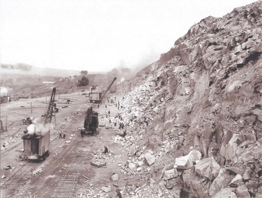
Album - Hume Reservoir Australia Album - View along the face of the quarry, August 1927, 1927
This set of photos is from a leather bound album bearing the inscription "HUME RESERVOIR AUSTRALIA" plus 'The Rt. Hon. L. C. M. S. Amery, P. C., M .P.' all inscribed in gold. It was presented to The Rt. Hon. L. C. M. S. Amery, P. C., M. P, Secretary of State for Dominion Affairs on the occasion of his visit to the Hume Reservoir on 2nd November 1927. This album is of local and national significance as it documents the planning and development of the Hume Reservoir up to 1927. It was the largest water reservoir in the British Empire. The album records the pioneering engineering work that went into its construction.DEPARTMENT OF PUBLIC WORKS, N.S.W. RIVER MURRAY WATERS SCHEME. HUME RESERVOIR. 35. Quarry. View along the face of the quarry. Granite is being quarried here for the concrete material. Blocks from 2-8 tons in weight are reserved for “plums”. Quantities of large size spalls are sent to Victoria for the toe of the embankment and other purposes but the greatest proportion of the stone is crushed at the quarry to 2½ inches gauge for concrete aggregate. Two steam navvies and two steam travelling cranes are at work on the face. New South Wales. August 1927.hume reservoir australia, river murray waters scheme, hume reservoir construction -
 University of Melbourne, Burnley Campus Archives
Newspaper - Newspaper Cutting, Bringing home the oats, 1944
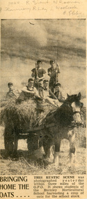
Helen Dudley has written above the photo: 1944 R. Grant, N. Rooney, J. Flannery, R. Lay, L. Woolcock, B. Ebbs. The caption below the photo reads: "This rustic scene was photographed yesterday within 3 miles of the GPO. It shows students of the Burnley Horticultural School harvesting oats for the school stock. All students graduated in 1944 except L. Woolcock, who graduated in 1945.Newspaper cutting with a photo of 6 male students standing on a cart of oats being pulled by a draught horse.leslie woolcock, helen dudley, r. grant, n. rooney, j. flannery, r. lay, b. ebbs, students working outside, horses -
 Wodonga & District Historical Society Inc
Album - Hume Reservoir Australia Album - Bethanga Bridge Site, August 1927
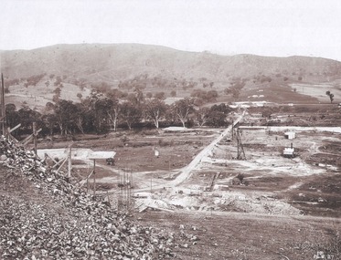
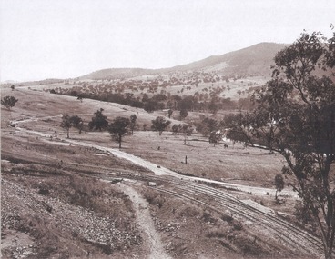
This set of photos is from a leather bound album bearing the inscription "HUME RESERVOIR AUSTRALIA" plus 'The Rt. Hon. L. C. M. S. Amery, P. C., M .P.' all inscribed in gold. It was presented to The Rt. Hon. L. C. M. S. Amery, P. C., M. P, Secretary of State for Dominion Affairs on the occasion of his visit to the Hume Reservoir on 2nd November 1927. This album is of local and national significance as it documents the planning and development of the Hume Reservoir up to 1927. It was the largest water reservoir in the British Empire. The album records the pioneering engineering work that went into its construction.DEPARTMENT OF PUBLIC WORKS, N.S.W. RIVER MURRAY WATERS SCHEME. HUME RESERVOIR. 37. Bethanga Bridge Site. A bridge is being built to cross the Reservoir to serve a large area of country which will be cut off from its natural outlets by the submergence of existing bridges when the Reservoir is in being. The site of the bridge is nearly a mile up the Murray from the Hume Reservoir Quarry. Its length will be approximately half a mile. There will be nine spans of 269 feet with steel truss girders resting on concrete pillars. Some of the pillars are founded on rock while others will rest on nests of reinforced concrete piles. The foundations and concrete piers are in the hands of the Victorian Constructing Authority and the superstructure in those of the New South Wales Authority. August 1927.hume reservoir australia, river murray waters scheme, hume reservoir construction -
 Wodonga & District Historical Society Inc
Album - Hume Reservoir Australia Album - Valley of the Murray to be crossed by the Bethanga Bridge 1927
This set of photos is from a leather bound album bearing the inscription "HUME RESERVOIR AUSTRALIA" plus 'The Rt. Hon. L. C. M. S. Amery, P. C., M .P.' all inscribed in gold. It was presented to The Rt. Hon. L. C. M. S. Amery, P. C., M. P, Secretary of State for Dominion Affairs on the occasion of his visit to the Hume Reservoir on 2nd November 1927. This album is of local and national significance as it documents the planning and development of the Hume Reservoir up to 1927. It was the largest water reservoir in the British Empire. The album records the pioneering engineering work that went into its construction.DEPARTMENT OF PUBLIC WORKS, N.S.W. RIVER MURRAY WATERS SCHEME. HUME RESERVOIR. 36. Valley of the Murray to be crossed by the Bethanga Bridge described in the next photograph. (WHS 00731) This view shows the marshalling sidings for trucks below the Quarry, New South Wales, and the branch line to the site of the bridge.hume reservoir australia, river murray waters scheme, hume reservoir construction -
 Melton City Libraries
Map, Mount Cottrell Fire group, Unknown
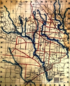
"In 1966, the Mount Cottrell Fire Brigades Group was formed as a way of consolidating the smaller groups around Melton, Rockbank, Toolern Vale, Sydenham, Truganina and Werribee. Its headquarters were established at the home of Ernest ‘Bon’ and Edna Barrie in Ferris Road, Melton. Captain Bon Barrie was a member of the Melton Fire Brigade and elected group and communications officer of the new Mount Cottrell Brigades Group". Fire Brigade Meeting 14th September held at Rockbank Formation a new Group in Region 14 Present: R/O H Rothsay, Assistant R/O R Orchard Tru? G Summerton Purpose of Group The pooling of the equipment in the area should be co-ordinated under one leader. The Brigade and private equipment should be co-ordinated under one leader. Formation was carried unanimously. To be called Mt Cotterill Group. Rockbank nominated Captain E W Barrie elected, Secretary K Watt Toolern Vale. Names listed C/O K L McNaughton Anakie Group COO/O R B Chirnside Lieut J Richmond Capt E Gillespie Toolern Vale Eddie L/ T S Atkin Stan L/T B Storey Bert Sec K Watt Keith Capt E W Barrie Melton Bon L/T K Gillespie Keith A Gillespie Arthur L/T G Lunson George L/T J Robinson Jeff Capt A Marquand Truganina Alan L/T I Cowie Ian Sec T Gard Tom Capt G Harrison Rockbank a/ps G Harrison N Harrison N Fisher a/ps S Hirt Melton Steve Pres M Chomley Sydenham Capt S Hughes Stan Capt L Waterson Werribee Lex Res/o J Hanson G/O S Cooper Bacchus Marsh Syd P/GO W Lidgett Wal Pro/O D Dunton G/O T Healy R C [Mt Macedon] Tom Reg Sec G Douglas Hand written notes of Edna Barrie Typed by Wendy Barrie Maps of the Mt Cottrell Fire groupemergency services, maps -
 Bendigo Military Museum
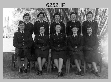
Photograph - WRAAC Personnel posted to the Army Headquarters Survey Regiment, Fortuna Bendigo, c1950s – 1960s
This is a collection of seven photographs of Women’s Royal Australian Army Corps (WRAAC) personnel posted to the Army Headquarters Survey Regiment, Fortuna, Bendigo circa 1957 to 1964. After the disbandment of the Australian Women's Army Service (AWAS) in 1947 there was only one or two of civilian women in administrative positions at Fortuna. In February 1957 female positions from the disbanded Southern Command Field Survey Section in Melbourne were transferred to newly established positions at the Army Headquarters Survey Regiment, Bendigo. They were accommodated at the newly acquired ‘Turriff’ mansion in Carpenter Street, Bendigo. Their first Officer Commanding (OC) was CAPT Beryl Perry from 1957 to September 1960. Her replacement as OC was CAPT Carol Castor who served in several positions up to June 1967. The main areas of employment in these early days were in administrative positions, draughting in and retouching in Lithographic Squadron. WO2 MA McLaren was the female to reach the rank of WO2 as a Cartographic Squadron section commander in June 1961. WO1 Marj Knight served at Fortuna from 1959 to 1978 was the first female to reach the rank of WO1. WO1 Knight served in the senior Squadron Sergeant-Major and Technical Warrant Officer positions of Cartographic Squadron. She was also the first female PMC of the Army Survey Regiment SGT’s Mess. The WRAAC uniform seen in this collection was replaced in 1979. As the Australian Army implemented the disbandment of the WRAAC as a separate corps in 1980, WRAAC personnel posted to Royal Australian Survey Corps units were integrated into RA Svy.This is a collection of seven photographs of Women’s Royal Australian Army Corps (WRAAC) personnel posted to the Army Headquarters Survey Regiment, Fortuna Bendigo circa 1957 to 1964. The photographs were printed on photographic paper and are part of the Army Survey Regiment’s Collection. The photographs were scanned at 300 dpi. .1) - Photo, black & white, c1957. Back row – unidentified personnel, Front row – centre: CAPT Beryl Perry, unidentified personnel. .2) - Photo, black & white, c1958. Back row – unidentified personnel, Front row L to R: unidentified, SGT MA McLaren, CAPT Beryl Perry, unidentified (x2). .3) - Photo, black & white c1959. Back row – unidentified personnel, Front row L to R: unidentified (x2), SGT MA McLaren, CAPT Carol Castor, unidentified (x3). .4) - Photo, black & white, October 1961. L to R: WO2 MA McLaren, PTE CA Brown, CAPT Carol Castor, PTE HS Pasley, PTE BJ Madex, CPL Marj Knight. .5) - Photo, black & white, October 1961. L to R: PTE BJ Madex, PTE HS Pasley, PTE CA Brown, WO2 MA McLaren, CPL Marj Knight. .6) - Photo, black & white, August 1963. Back row – L to R: PTE Hollingsworth, PTE GM Hill, PTE PE Sykes, PTE Nola Strawbridge, PTE Jan Cruickshank, PTE Margaret Taylor, PTE Prescott, PTE RR Hutton, PTE BJ Madex, PTE BM Fuhrmann, PTE Cockburn. Front row – L to R: PTE NA Falot, LCPL JA Hurst, SGT Marj Knight, CAPT Carol Caster, CPL Jennifer Murray, LCPL A Burrows, unidentified. .7) - Photo, black & white, 1964. Back row – L to R: PTE Dianne Fowler, PTE Leslie Mortimer, PTE Marlene Penglase, PTE Marg Cooper, PTE Irene Rankins, PTE Elaine Veith, PTE Lyn Ireland, PTE Marg Murphy, PTE Nola Downes, PTE Joan Lawler, PTE Henni Schunck. Front row – L to R: PTE Loretta Hall, LCPL Jo McNamara, SGT Marj Knight, CAPT Carol Caster, CPL Nola Strawbridge, PTE Mary McHugh, PTE Kalen Sargent..1P to .3P, .7P - no annotation, .4P to .6P - Personnel (surnames, no rank) annotated on back.royal australian survey corps, rasvy, army survey regiment, army svy regt, fortuna, asr, wraac -
 Bendigo Military Museum
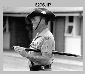
Photograph - Army Survey Regiment - Defence Force Service Medal Presentations, Fortuna Villa, Bendigo, 1995
These nine photographs of a CO’s Parade were taken on the 6th of December 1995 at the Army Survey Regiment, Fortuna, Bendigo. On this occasion CO LTCOL Duncan Burns presented the Defence Force Service Medal to SSGT Stephen Hill OAM CSM, SGT Stuart Ridge, SGT Peter Peterson and CPL Eric Nicolson for 15 years of efficient remunerated service in the Australian Army.This is a set of nine photographs taken at the CO’s Parade at the Army Survey Regiment, Fortuna, Bendigo, on the 6th of December 1995. The photographs were printed on photographic paper and are part of the Army Survey Regiment’s Collection. The photographs were scanned at 300 dpi. .1) - Photo, black & white, 1995. RSM WO1 Ken Johnston OAM MM. .2) - Photo, black & white, 1995. L to R: CAPT Tony Harder – UK Exchange Officer, CAPT Doug Arman. .3) - Photo, colour, 1995. L to R: WO2 Paul Leskovec CSM, unidentified, WO2 Kevin Kennedy, SSGT Peter Curtis, CPL John ‘JJ’ Smith, SGT Peter Peterson, CAPT Tony Harder (foreground), unidentified, SSGT Stephen Hill OAM CSM, CAPT Doug Arman (foreground). .4) - Photo, colour, 1995. L to R: MAJ Mick Banham, RSM Ken Johnston OAM MM, CAPT Tony Harder, QM CAPT Bill Griggs, SSGT Peter Curtis CPL John ‘JJ’ Smith, unidentified, SGT Peter Peterson, ADJT CAPT Brenton McDonald, CAPT Doug Arman, SSGT Stephen Hill OAM CSM, remainder unidentified. CAPT Bin Fashar Sutimin – Indonesian Exchange Officer in dark green uniform with gold lanyard. .5) - Photo, colour, 1995. L to R: CAPT Bin Fashar Sutimin – Indonesian Exchange Officer in dark green uniform with gold lanyard, unidentified (x5) SSGT Bob Thrower, unidentified SGT Peter Tuddenham, remainder unidentified. .6) - Photo, colour, 1995. L to R: RSM Ken Johnston OAM MM, ADJT CAPT Brenton McDonald, WO2 Pat Lumsden (partially obscured), CO LTCOL Duncan Burns. Defence Force Service Medal recipient - SSGT Stephen Hill OAM CSM. .7) - Photo, colour, 1995. L to R: WO2 Pat Lumsden (partially obscured), CO LTCOL Duncan Burns. Defence Force Service Medal recipient – SGT Stuart Ridge. .8) - Photo, colour, 1995. L to R: CO LTCOL Duncan Burns. Defence Force Service Medal recipient – CPL Eric Nicolson. .9) - Photo, colour, 1995. L to R: WO2 Pat Lumsden, CO LTCOL Duncan Burns. Defence Force Service Medal recipient – SGT Peter Peterson..1P to.9P – The occasion and date are annotated on the plastic sleeve and the back of the photos.royal australian survey corps, rasvy, army survey regiment, army svy regt, fortuna, asr -
 Eltham District Historical Society Inc
Photograph, Shire of Eltham Councillors visit to the Board of Works, Upper Thomson's Quarters, West Gipplsand, 3-5 December, 1971
Original Title: Visit to Upper Thomson's Quarters, Board of Works, 3-5 December, 1971 Shire of Eltham Councilors and an ex councilor visiting the early works leading up to the construction of the Thomson Dam, located in West Gippsland, Victoria. Standing Back (L-R): Ex. Cr. H. Bartlett, Cr. P. Graham Middle Row (L to R): Cr. D. Ingersole, Cr. A. Glover (Shire President), seated - Cr. E.A. Hale, Cr. C.J. Bock (Shire Secretary/ Chief Administrative Officer), standing - Cr. J. White, Cr. L.E. Clarke, Mr. H. Jackson (M.M.B.W.) Seated Front (L-R): Cr. G.C. Dreverman and Cr. A.S. Knox Source: Shire of ElthamThis photo forms part of a collection of photographs gathered by the Shire of Eltham for their centenary project book,"Pioneers and Painters: 100 years of the Shire of Eltham" by Alan Marshall (1971). The collection of over 500 images is held in partnership between Eltham District Historical Society and Yarra Plenty Regional Library (Eltham Library) and is now formally known as the 'The Shire of Eltham Pioneers Photograph Collection.' It is significant in being the first community sourced collection representing the places and people of the Shire's first one hundred years.Digital imagealistair knox, cr. a. glover, cr. a.s. knox, cr. c.j. bock, cr. d. ingersole, cr. e.a. hale, cr. g.c. dreverman, cr. h. bartlett, cr. j. white, cr. l.e. clarke, cr. p. graham, melbourne metropolitan board of works, mmbw, mr. h. jackson, other areas, shire of eltham pioneers photograph collection, upper thomson's quarters -
 Stawell Historical Society Inc
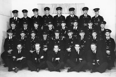
Photograph, Stawell Urban Fire Brigade Discipline Team in Uniform in Bendigo 1938
Group Portrait of Stawell Urban Fire Brigade Discipline Team Bendigo 1938 in uniform BACK ROW: E. Welsh (Ted), Ern Dickens, Albert Smith, Jack Hall, Jack Miatke, Henry Dunn, Charlie Prosser, Arthur Parsons SECOND ROW L-R: Chas Richardson. Fred Crouch, I. O'Neil (Bunny), Harry Chapman, Reg Chapman, Roy Ledger, Bill Mitchell, A. Dunn (Bert) THIRD ROW L-R: Bob Phillips, Sid Whelan, Fred Court, George Huse (Gundy), Ray Maddocks, Frank Floyd, Peter Fenwick, Ray Rickard, Reg Nicholls SEATED FRONT ROW L-R: ?, Ridgewell, S. McInnes, B. Aston, ? , Len Egginton Black & white photograph of a group of men in uniform. Most men are wearing uniform hates, front row have no hats. Taken indoors, window behind the group.nonestawell -
 Ballarat Tramway Museum
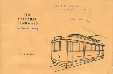
Book, Keith Kings, "The Ballarat Tramways", Sep. 1971
Yields information about the history of the Ballarat Tramways from horse to the closure of the electric trams in 1971. Gives a good understanding of the development and operation of the tramways. Has a strong association with the author.Book, 64 pages, gloss art paper, in black ink with a light brown card cover in green ink, centre stapled, titled "The Ballarat Tramways" Details history of Ballarat tramways, its tramcars and the involvement of the various operators. Has maps and photographs. Written by Keith Kings and published by the Victorian Division of the Australian Railway Historical Society at the time of the closure of the Ballarat system. Inside front cover is a typed sheet of amendments for the book - typed on Charles Martin Watermarked paper. Has details of the various organisations that published the book on the rear cover. 114.2 - as for 114.1 - but with many hand written notes etc. 114.3 - as for 114.1 - but with "City of Ballarat" stamped on front cover. 114.4 - as for 114.1 - but with "To Mr. L. J. Denmead, Departmental Tramways Supt. from K. Kings 12/9/1971" handwritten on front cover. For entire book see pdf images i1 to i3.114.2 - notes on pages 7, 10, 17, 18, 21, 22, 23, 25, 26, 29, 36, 49 and 63 - has in blue or black ink, many notes, corrections and additions. 114.3 - "City of Ballaarat" stamped in red on top right hand corner. 114.4 - "To Mr. L. J. Denmead, Departmental Tramways Supt. from K. Kings 12/9/1971" handwritten on front cover in blue ink and on title page (page 1) in red ink "Mr. L. J. Denmead / Dear Les, / Best Wishes for the future! / Bob Prentice" and on same page, in blue stamp "L.J. Denmead".trams, tramways, ballarat tramways, history, tramcars of ballarat -
 Federation University Historical Collection
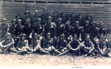
Photograph, Colin Campbell Price and the 8th Battalion Senior Cadets at Daylesford
Five images relating to Colin Campbell Price and military Service. .1) Colin Campbell Price .2) 8th Battalion Senior Cadets at Daylesford, 193? .3) HMAS Albatross 808 Squadron in front of an aeroplane and hanger. .4) Darwin mess mates of Colin Price .5) Twenty uniformed men in 1948 - Fleet Arm - HMS Condor - C4 Conversion Course. Back Row L-R: K. Roberts, J. Lamb, N. Hallas, A. Woods, H. Gid=bson, G. Coker-Godson, M. Green, K. Nicholls, M. Gardener. Centre Row L -R: D. Eastgate, B. Gilroy, R.Smith, G. Foale, J. Sergeant, A. Sara, R. Higgins. Front Row L-R: Colin Price, E. Barker, S. Cox, S. Paul -
 Bendigo Military Museum
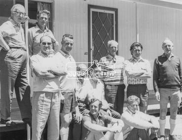
Photograph - Detachment - Army Survey Regiment, Bonegilla, Victoria, c1973
This is a set of three photographs of personnel from the Detachment - Army Survey Regiment taken in front of its main map production building at Bonegilla, Victoria in c1973. This cartographic map production sub-unit of the Army Survey Regiment operated in buildings owned by the School of Military Survey from 17th of June 1970 to the 30th of September 1985. A total of 800 topographic maps ranging in scale from 1:25,000 to 1: 250,000 scale were completed. A major focus of production in the 1970s was the cartographic completion of the Papua-New Guinea 1:100,000 map series and the Flexiflow quality control system was developed as a tool to coordinate production. The Flexiflow system comprised a series of job plans and charts linked to a task allocation to resource magnetic planning board. Using critical path analysis and task prioritisation, complex job planning was efficiently scheduled, and re-prioritisations readily made. Reproduction requirements were effectively coordinated by way of weekly courier to the Army Survey Regiment at Bendigo. Supervisors and technicians fully embraced the system as they could understand their role, others around them and the positive production achievements. WO1 Bill Boyd (who does not appear in this photograph) was the technical warrant officer for 11 years at the Detachment was awarded the OAM, the Order of Australia Medal for leading the development and the implementation of the Flexiflow system. By mid-1982, production of maps at these scales was undertaken digitally on Bendigo’s AUTOMAP 2 system and the Detachment reverted to production of small-scale large format RAAF aeronautical charts. Detachment personnel managed to produce 18 charts in the following two years, which was an impressive achievement for the staff, given major differences in format, specification and scales. Development of digital production of aeronautical charts in 1984-85 led to gradual reduction in production output and contracting out production was instigated to meet the shortfall and as a consequence the Detachment closed in September 1985. See pages 177 to 180 of Valerie Lovejoy’s book 'Mapmakers of Fortuna – A history of the Army Survey Regiment’ ISBN: 0-646-42120-4. for more information on the history of the Detachment at Bonegilla.This is a set of three photographs of the Detachment - Army Survey Regiment taken in front of the main map production building at Bonegilla, Victoria in c1973. The photographs were printed on photographic paper and are part of the Army Survey Regiment’s Collection. The photographic proofs were scanned at 600 dpi. .1) to .3) - Photo, black & white c1973. Back Row L to R: Peter Simpson, Chris Edwards, unidentified (x2), Colin Harden, Rowan Gillies, Bob Rowley OAM, Steve Hansen, Stu Thaxter. Centre Row L to R: Kevin Boehm, Dennis McCarthy, Peter Cross, unidentified, Brian Ryan, unidentified, Ian Marner, unidentified, Phil Smalley. Front Row L to R: Geoff Haynes, Bruce Wetzig, Dave Thompson, unidentified, OC Bob Roche, Ike Lever, John McCulloch, Dick Barwald, unidentified. There are no personnel annotated.royal australian survey corps, rasvy, army survey regiment, detachment - army survey regiment, army svy regt, asr