Showing 167 items
matching kiewa river
-
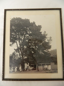
 The Beechworth Burke Museum
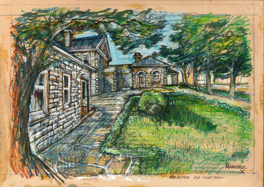
Drawing, Ernest Marcuse, Beechworth – Old Court House, 1972
... in North east Victoria 'Kiewa river bridge', 'Hume weir', ' Dried... in North east Victoria 'Kiewa river bridge', 'Hume weir', ' Dried ...Ernest Heinrich Marcuse was born on the 1st of December 1900 to Hedwig and Siegmund Marcuse in Berlin Germany. While Marcuse's artistic talent was apparent from a younger age, his earliest existing artwork was from when he was approximately 20 years old. Ernest's formal art training commenced in 1918 with a three year course at the Berlin school of Interior design. After completion he found work until 1924 when Germany's Great Depression took effect. To broaden his career opportunities he undertook a further 12 months study of fashion, drawing and advertising at Berlin's Reiman school of art. From 1925 to 1934 Ernest was primarily a freelance press artist specialising in industrial, architectural and figurative drawing. Prominent newspaper The Berliner Morgenpost was his largest client along with Gross Deutsche Rundfunaustellung (Germany's organisation for major trade shows). During this period he would create many significant works. Two months after Hitler and the Nazi part came to power in 1933, Ernest received a life changing letter stating that being Jewish he could no longer continue employment in Germany. Up until 1938 he would only be able to undertake private commissions and occasional unofficial work as a book illustrator and games designer. This was by arrangement with non Jewish artists who claimed his work as their own, they would then share the income with Ernest. With increasing unrest in Germany during late 1938 Ernest decided to move to London and there he married his girlfriend Lotte. In late 1939 Ernest and Lotte Marcuse embarked on an eight week journey to their new home in Australia where they had been accepted as refugees. Shortly after arriving in Australia Ernest presented his portfolio to an editor at the Argus newspaper and gained employment as a war events illustrator. He soon became well respected and known in particular for his detailed illustrations and cross sections of ships , artillery and aircrafts. His detailed depictions of battles were displayed on the front pages of The Argus newspaper on a number of occasions. In May 1940 as the war intensified Ernest was dismissed from The Argus newspaper due to his Australian government classification of 'stateless person of enemy origin' and was considered a potential security risk. The editor of the time commented "don't blame us, blame Hitler". Marcuse then began to establish himself as a commercial artist. Ernest was de-classified as a 'stateless person of enemy origin' and in early 1942. The Australian army heard of Ernest's artistic abilities and began to utilize his designs for visual training aids and posters. Ernest became Private E.H Marcuse V377746, his first army posting was as staff artist at The infantry officer's training school at Bonegilla. When off duty he was inspired by the beauty of the surrounding area creating the works in North east Victoria 'Kiewa river bridge', 'Hume weir', ' Dried up river bed' and 'Hawksview gold reef mine' from his 1942-1943 period at Bonegilla Victoria. Ernest returned to the area to create drawings and paintings from 1948 to 1983 in locations including Bright, Wandilligong, Bogong High plains and Wallace's Hut, Mt Buffalo, Beechworth, Pretty valley, Kiewa Hydro, Yackandandah and Bontherambo homestead. These sketches were often completed on location, photographs were also taken onsite to assist the works back at the studio. Occasionally Marcuse also painted in the field. Ernest's preferred choice of medium was pencil and ink. Up until 1952 he would often incorporate watercolour into his work. Later into his career he began introducing pastels, acrylic and mixed media. In earlier years Ernest Marcuse often signed his work Mar, later on the signing of works ranged from Marcuse, E.Marcuse, Ernest Marcuse, EHM or simply EM . If a work was considered incomplete or Marcuse did not like the work it would remain unsigned. From Bonegilla Marcuse was transferred to Woodside South Australia before his final posting in Melbourne until the end of 1945. Ernest's work from within his army posting 'Troop Train at Night' from his 1945 exhibition Australia at War are part of the permanent collection at Canberra's War Museum. Between 1946 and 1969 Ernest largely worked from home and concentrated on a career as a freelance commercial artist and graphic designer. During that time he created work for well known household names including CRA/Conzinc, Vacuum oil (Caltex), Cottee's Brand (Schweppes and Heinz), Home Beautiful magazine Fulton garden supplies, International Iveco trucks, Ego pharmaceuticals, QV and Sunsense. After retirement Ernest concentrated on his true love of fine art and focused on painting images of personal interest both across Australia and Internationally. Earnest never drove a car. He would often walk or use public transport or enlist in the help of family or artist friends to drive him. Throughout his career Ernest Marcuse's artworks were purchase by private collectors these included ACTU, Melbourne City council, Holland Constructions, Melbourne Metropolitan Tramways Board, GJ Coles and Australian Resources Bank. Ernest Marcuse permanent collections can be viewed at The National Gallery of Victoria , Sydney Jewish Museum, Jewish Holocaust Centre Melbourne, Canberra's War Museum, City of Melbourne, Shire of Yarra ranges and now the Burke Museum. © 2020 Art by Marcuse https://www.artbymarcuse.com.au/aboutDonated to the Burke Museum through the Australian Government's Cultural Gifts Program by Peter and Evelyn MarcusePen and coloured pencil landscape drawing on paper.Obverse: Marcuse / Beechworth Old Courthouse / Reverse: B4 / BEECHWORTH OLD COURTHOUSE / BW - 09 (on masking tape) COURTHOUSE / BEECHWORTH / VICTORIA / NATIONAL TRUST / CLASS (A) ERNEST MARCUSE / 17 CADDOCK AVE / CAUFIELD / VIC / 53-7374 001 (pencil) ernest marcuse, marcuse, art, artbymarcuse, beechworth, burke museum, indigo shire, landscape, illustration, drawing, pen and pencil, australian army, war events illustrator, the age, the sun, the argus, germany, refugee, industrial drawing, architectual drawing, figure drawing, berliner morgenpost, grosse deutsche rundfunaustellung, berlin’s reiman school of art., cultural gifts program -
 The Beechworth Burke Museum
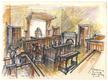
Drawing, Ernest Marcuse, Courthouse - Beechworth, 1974
... in North east Victoria 'Kiewa river bridge', 'Hume weir', ' Dried... in North east Victoria 'Kiewa river bridge', 'Hume weir', ' Dried ...Ernest Heinrich Marcuse was born on the 1st of December 1900 to Hedwig and Siegmund Marcuse in Berlin Germany. While Marcuse's artistic talent was apparent from a younger age, his earliest existing artwork was from when he was approximately 20 years old. Ernest's formal art training commenced in 1918 with a three year course at the Berlin school of Interior design. After completion he found work until 1924 when Germany's Great Depression took effect. To broaden his career opportunities he undertook a further 12 months study of fashion, drawing and advertising at Berlin's Reiman school of art. From 1925 to 1934 Ernest was primarily a freelance press artist specialising in industrial, architectural and figurative drawing. Prominent newspaper The Berliner Morgenpost was his largest client along with Gross Deutsche Rundfunaustellung (Germany's organisation for major trade shows). During this period he would create many significant works. Two months after Hitler and the Nazi part came to power in 1933, Ernest received a life changing letter stating that being Jewish he could no longer continue employment in Germany. Up until 1938 he would only be able to undertake private commissions and occasional unofficial work as a book illustrator and games designer. This was by arrangement with non Jewish artists who claimed his work as their own, they would then share the income with Ernest. With increasing unrest in Germany during late 1938 Ernest decided to move to London and there he married his girlfriend Lotte. In late 1939 Ernest and Lotte Marcuse embarked on an eight week journey to their new home in Australia where they had been accepted as refugees. Shortly after arriving in Australia Ernest presented his portfolio to an editor at the Argus newspaper and gained employment as a war events illustrator. He soon became well respected and known in particular for his detailed illustrations and cross sections of ships , artillery and aircrafts. His detailed depictions of battles were displayed on the front pages of The Argus newspaper on a number of occasions. In May 1940 as the war intensified Ernest was dismissed from The Argus newspaper due to his Australian government classification of 'stateless person of enemy origin' and was considered a potential security risk. The editor of the time commented "don't blame us, blame Hitler". Marcuse then began to establish himself as a commercial artist. Ernest was de-classified as a 'stateless person of enemy origin' and in early 1942. The Australian army heard of Ernest's artistic abilities and began to utilize his designs for visual training aids and posters. Ernest became Private E.H Marcuse V377746, his first army posting was as staff artist at The infantry officer's training school at Bonegilla. When off duty he was inspired by the beauty of the surrounding area creating the works in North east Victoria 'Kiewa river bridge', 'Hume weir', ' Dried up river bed' and 'Hawksview gold reef mine' from his 1942-1943 period at Bonegilla Victoria. Ernest returned to the area to create drawings and paintings from 1948 to 1983 in locations including Bright, Wandilligong, Bogong High plains and Wallace's Hut, Mt Buffalo, Beechworth, Pretty valley, Kiewa Hydro, Yackandandah and Bontherambo homestead. These sketches were often completed on location, photographs were also taken onsite to assist the works back at the studio. Occasionally Marcuse also painted in the field. Ernest's preferred choice of medium was pencil and ink. Up until 1952 he would often incorporate watercolour into his work. Later into his career he began introducing pastels, acrylic and mixed media. In earlier years Ernest Marcuse often signed his work Mar, later on the signing of works ranged from Marcuse, E.Marcuse, Ernest Marcuse, EHM or simply EM . If a work was considered incomplete or Marcuse did not like the work it would remain unsigned. From Bonegilla Marcuse was transferred to Woodside South Australia before his final posting in Melbourne until the end of 1945. Ernest's work from within his army posting 'Troop Train at Night' from his 1945 exhibition Australia at War are part of the permanent collection at Canberra's War Museum. Between 1946 and 1969 Ernest largely worked from home and concentrated on a career as a freelance commercial artist and graphic designer. During that time he created work for well known household names including CRA/Conzinc, Vacuum oil (Caltex), Cottee's Brand (Schweppes and Heinz), Home Beautiful magazine Fulton garden supplies, International Iveco trucks, Ego pharmaceuticals, QV and Sunsense. After retirement Ernest concentrated on his true love of fine art and focused on painting images of personal interest both across Australia and Internationally. Earnest never drove a car. He would often walk or use public transport or enlist in the help of family or artist friends to drive him. Throughout his career Ernest Marcuse's artworks were purchase by private collectors these included ACTU, Melbourne City council, Holland Constructions, Melbourne Metropolitan Tramways Board, GJ Coles and Australian Resources Bank. Ernest Marcuse permanent collections can be viewed at The National Gallery of Victoria , Sydney Jewish Museum, Jewish Holocaust Centre Melbourne, Canberra's War Museum, City of Melbourne, Shire of Yarra ranges and now the Burke Museum. © 2020 Art by Marcuse https://www.artbymarcuse.com.au/aboutDonated to the Burke Museum through the Australian Government's Cultural Gifts Program by Peter and Evelyn MarcusePen and coloured pencil landscape drawing on paper.Obverse: Marcuse 74 / Courthouse / Visitor Ned Kelly . B'worth Reverse: BEECHWORTH / COURTHOUSE / B5 / 06 ernest marcuse, marcuse, art, artbymarcuse, beechworth, burke museum, indigo shire, landscape, illustration, drawing, pen and pencil, australian army, war events illustrator, the age, the sun, the argus, germany, refugee, industrial drawing, architectual drawing, figure drawing, berliner morgenpost, grosse deutsche rundfunaustellung, berlin’s reiman school of art., cultural gifts program -
 The Beechworth Burke Museum
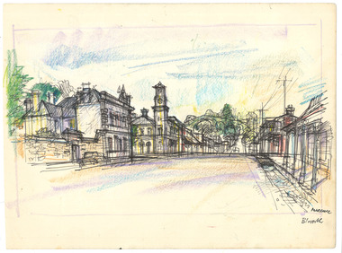
Drawing, Ernest Marcuse, Beechworth I, c1972-1976
... in North east Victoria 'Kiewa river bridge', 'Hume weir', ' Dried... in North east Victoria 'Kiewa river bridge', 'Hume weir', ' Dried ...Ernest Heinrich Marcuse was born on the 1st of December 1900 to Hedwig and Siegmund Marcuse in Berlin Germany. While Marcuse's artistic talent was apparent from a younger age, his earliest existing artwork was from when he was approximately 20 years old. Ernest's formal art training commenced in 1918 with a three year course at the Berlin school of Interior design. After completion he found work until 1924 when Germany's Great Depression took effect. To broaden his career opportunities he undertook a further 12 months study of fashion, drawing and advertising at Berlin's Reiman school of art. From 1925 to 1934 Ernest was primarily a freelance press artist specialising in industrial, architectural and figurative drawing. Prominent newspaper The Berliner Morgenpost was his largest client along with Gross Deutsche Rundfunaustellung (Germany's organisation for major trade shows). During this period he would create many significant works. Two months after Hitler and the Nazi part came to power in 1933, Ernest received a life changing letter stating that being Jewish he could no longer continue employment in Germany. Up until 1938 he would only be able to undertake private commissions and occasional unofficial work as a book illustrator and games designer. This was by arrangement with non Jewish artists who claimed his work as their own, they would then share the income with Ernest. With increasing unrest in Germany during late 1938 Ernest decided to move to London and there he married his girlfriend Lotte. In late 1939 Ernest and Lotte Marcuse embarked on an eight week journey to their new home in Australia where they had been accepted as refugees. Shortly after arriving in Australia Ernest presented his portfolio to an editor at the Argus newspaper and gained employment as a war events illustrator. He soon became well respected and known in particular for his detailed illustrations and cross sections of ships , artillery and aircrafts. His detailed depictions of battles were displayed on the front pages of The Argus newspaper on a number of occasions. In May 1940 as the war intensified Ernest was dismissed from The Argus newspaper due to his Australian government classification of 'stateless person of enemy origin' and was considered a potential security risk. The editor of the time commented "don't blame us, blame Hitler". Marcuse then began to establish himself as a commercial artist. Ernest was de-classified as a 'stateless person of enemy origin' and in early 1942. The Australian army heard of Ernest's artistic abilities and began to utilize his designs for visual training aids and posters. Ernest became Private E.H Marcuse V377746, his first army posting was as staff artist at The infantry officer's training school at Bonegilla. When off duty he was inspired by the beauty of the surrounding area creating the works in North east Victoria 'Kiewa river bridge', 'Hume weir', ' Dried up river bed' and 'Hawksview gold reef mine' from his 1942-1943 period at Bonegilla Victoria. Ernest returned to the area to create drawings and paintings from 1948 to 1983 in locations including Bright, Wandilligong, Bogong High plains and Wallace's Hut, Mt Buffalo, Beechworth, Pretty valley, Kiewa Hydro, Yackandandah and Bontherambo homestead. These sketches were often completed on location, photographs were also taken onsite to assist the works back at the studio. Occasionally Marcuse also painted in the field. Ernest's preferred choice of medium was pencil and ink. Up until 1952 he would often incorporate watercolour into his work. Later into his career he began introducing pastels, acrylic and mixed media. In earlier years Ernest Marcuse often signed his work Mar, later on the signing of works ranged from Marcuse, E.Marcuse, Ernest Marcuse, EHM or simply EM . If a work was considered incomplete or Marcuse did not like the work it would remain unsigned. From Bonegilla Marcuse was transferred to Woodside South Australia before his final posting in Melbourne until the end of 1945. Ernest's work from within his army posting 'Troop Train at Night' from his 1945 exhibition Australia at War are part of the permanent collection at Canberra's War Museum. Between 1946 and 1969 Ernest largely worked from home and concentrated on a career as a freelance commercial artist and graphic designer. During that time he created work for well known household names including CRA/Conzinc, Vacuum oil (Caltex), Cottee's Brand (Schweppes and Heinz), Home Beautiful magazine Fulton garden supplies, International Iveco trucks, Ego pharmaceuticals, QV and Sunsense. After retirement Ernest concentrated on his true love of fine art and focused on painting images of personal interest both across Australia and Internationally. Earnest never drove a car. He would often walk or use public transport or enlist in the help of family or artist friends to drive him. Throughout his career Ernest Marcuse's artworks were purchase by private collectors these included ACTU, Melbourne City council, Holland Constructions, Melbourne Metropolitan Tramways Board, GJ Coles and Australian Resources Bank. Ernest Marcuse permanent collections can be viewed at The National Gallery of Victoria , Sydney Jewish Museum, Jewish Holocaust Centre Melbourne, Canberra's War Museum, City of Melbourne, Shire of Yarra ranges and now the Burke Museum. © 2020 Art by Marcuse https://www.artbymarcuse.com.au/aboutDonated to the Burke Museum through the Australian Government's Cultural Gifts Program by Peter and Evelyn MarcusePen and coloured pencil landscape drawing on paper.Obverse: MARCUSE / B.worth (in pen) Reverse: BEECHWORTH NOSTALGIA / BW – 01 (crossed out) / B2 / CORNER CAMP + FORD STREET / (on masking tape) 001 (pencil) ernest marcuse, marcuse, art, artbymarcuse, beechworth, burke museum, indigo shire, landscape, illustration, drawing, pen and pencil, australian army, war events illustrator, the age, the sun, the argus, germany, refugee, industrial drawing, architectual drawing, figure drawing, berliner morgenpost, grosse deutsche rundfunaustellung, berlin’s reiman school of art., cultural gifts program -
 The Beechworth Burke Museum
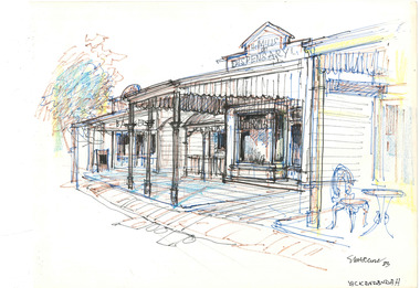
Drawing, Ernest Marcuse, Yackandandah I, 1983
... in North east Victoria 'Kiewa river bridge', 'Hume weir', ' Dried... in North east Victoria 'Kiewa river bridge', 'Hume weir', ' Dried ...Ernest Heinrich Marcuse was born on the 1st of December 1900 to Hedwig and Siegmund Marcuse in Berlin Germany. While Marcuse's artistic talent was apparent from a younger age, his earliest existing artwork was from when he was approximately 20 years old. Ernest's formal art training commenced in 1918 with a three year course at the Berlin school of Interior design. After completion he found work until 1924 when Germany's Great Depression took effect. To broaden his career opportunities he undertook a further 12 months study of fashion, drawing and advertising at Berlin's Reiman school of art. From 1925 to 1934 Ernest was primarily a freelance press artist specialising in industrial, architectural and figurative drawing. Prominent newspaper The Berliner Morgenpost was his largest client along with Gross Deutsche Rundfunaustellung (Germany's organisation for major trade shows). During this period he would create many significant works. Two months after Hitler and the Nazi part came to power in 1933, Ernest received a life changing letter stating that being Jewish he could no longer continue employment in Germany. Up until 1938 he would only be able to undertake private commissions and occasional unofficial work as a book illustrator and games designer. This was by arrangement with non Jewish artists who claimed his work as their own, they would then share the income with Ernest. With increasing unrest in Germany during late 1938 Ernest decided to move to London and there he married his girlfriend Lotte. In late 1939 Ernest and Lotte Marcuse embarked on an eight week journey to their new home in Australia where they had been accepted as refugees. Shortly after arriving in Australia Ernest presented his portfolio to an editor at the Argus newspaper and gained employment as a war events illustrator. He soon became well respected and known in particular for his detailed illustrations and cross sections of ships , artillery and aircrafts. His detailed depictions of battles were displayed on the front pages of The Argus newspaper on a number of occasions. In May 1940 as the war intensified Ernest was dismissed from The Argus newspaper due to his Australian government classification of 'stateless person of enemy origin' and was considered a potential security risk. The editor of the time commented "don't blame us, blame Hitler". Marcuse then began to establish himself as a commercial artist. Ernest was de-classified as a 'stateless person of enemy origin' and in early 1942. The Australian army heard of Ernest's artistic abilities and began to utilize his designs for visual training aids and posters. Ernest became Private E.H Marcuse V377746, his first army posting was as staff artist at The infantry officer's training school at Bonegilla. When off duty he was inspired by the beauty of the surrounding area creating the works in North east Victoria 'Kiewa river bridge', 'Hume weir', ' Dried up river bed' and 'Hawksview gold reef mine' from his 1942-1943 period at Bonegilla Victoria. Ernest returned to the area to create drawings and paintings from 1948 to 1983 in locations including Bright, Wandilligong, Bogong High plains and Wallace's Hut, Mt Buffalo, Beechworth, Pretty valley, Kiewa Hydro, Yackandandah and Bontherambo homestead. These sketches were often completed on location, photographs were also taken onsite to assist the works back at the studio. Occasionally Marcuse also painted in the field. Ernest's preferred choice of medium was pencil and ink. Up until 1952 he would often incorporate watercolour into his work. Later into his career he began introducing pastels, acrylic and mixed media. In earlier years Ernest Marcuse often signed his work Mar, later on the signing of works ranged from Marcuse, E.Marcuse, Ernest Marcuse, EHM or simply EM . If a work was considered incomplete or Marcuse did not like the work it would remain unsigned. From Bonegilla Marcuse was transferred to Woodside South Australia before his final posting in Melbourne until the end of 1945. Ernest's work from within his army posting 'Troop Train at Night' from his 1945 exhibition Australia at War are part of the permanent collection at Canberra's War Museum. Between 1946 and 1969 Ernest largely worked from home and concentrated on a career as a freelance commercial artist and graphic designer. During that time he created work for well known household names including CRA/Conzinc, Vacuum oil (Caltex), Cottee's Brand (Schweppes and Heinz), Home Beautiful magazine Fulton garden supplies, International Iveco trucks, Ego pharmaceuticals, QV and Sunsense. After retirement Ernest concentrated on his true love of fine art and focused on painting images of personal interest both across Australia and Internationally. Earnest never drove a car. He would often walk or use public transport or enlist in the help of family or artist friends to drive him. Throughout his career Ernest Marcuse's artworks were purchase by private collectors these included ACTU, Melbourne City council, Holland Constructions, Melbourne Metropolitan Tramways Board, GJ Coles and Australian Resources Bank. Ernest Marcuse permanent collections can be viewed at The National Gallery of Victoria , Sydney Jewish Museum, Jewish Holocaust Centre Melbourne, Canberra's War Museum, City of Melbourne, Shire of Yarra ranges and now the Burke Museum. © 2020 Art by Marcuse https://www.artbymarcuse.com.au/aboutDonated to the Burke Museum through the Australian Government's Cultural Gifts Program by Peter and Evelyn MarcusePen and coloured pencil landscape drawing on paper.Obverse: MILLS / DISPENSARY / MARCUSE 83 / YACKANDANDAH Reverse: Y 12 / ernest marcuse, marcuse, art, artbymarcuse, beechworth, burke museum, indigo shire, landscape, illustration, drawing, pen and pencil, australian army, war events illustrator, the age, the sun, the argus, germany, refugee, industrial drawing, architectual drawing, figure drawing, berliner morgenpost, grosse deutsche rundfunaustellung, berlin’s reiman school of art., cultural gifts program, yackandandah -
 Kiewa Valley Historical Society
Photo Framed - Bogong Hotel, c 1930's
... the Upper Kiewa River until it was burnt down in December 2011. Its ...The Bogong Hotel, Tawonga, was 125 years old and destroyed by fire early December 2011. Mr and Mrs Crotty started the hotel - one daughter married a Higginson and they ran the pub for a number of years. The Hore family then took over - Dick and Essie, followed by Norman and Vera, then the other Hore brothers. The Bogong Hotel was 125 years old and the meeting place for people living along the Upper Kiewa River until it was burnt down in December 2011. Its publican was Vera Hore. Vera Margaret Elizabeth Hore was born 20th Nov. 1909 and died in July 2000. She was a keen amateur photographer. Black and white photo of a car in the front of the Bogong Hotel with two large trees. Framed with a 2 cm wide cream card board border and a black metal decorated frame surrounding it.On the back: "Vera Hore / Bogong Hotel"pub, upper kiewa valley, bogong hotel, vera hore, photographer -
 Kiewa Valley Historical Society
Photo - Junction Dam Diversion Tunnel
Junction (Lake Guy) Dam is a 'slab and buttress' type wall. A timber frame is built and then filled with concrete. The first batch of concrete was placed in September, 1940. By June, 1941 the buttresses were finished to a height safe from floods and in October of that year a flood of 2,800 cusecs occurred but with only slight damage to the installations. Industrial trouble caused some delays but there was also slow progress on the part of the contractor and the work was taken over by the S.E.C., terminating the contract. The dam was completed in March, 1944. A walkway was made through the dam wall. Lake Guy was named after Mr. L.T. Guy who was the Resident engineer, in charge of construction work and associated activities on the Kiewa Area from 1939 to November 1946.Diversion dams are installed to raise the water level of a body of water to be redirected. The redirected water is used for hydro electric power generation. A diversion tunnel is usually bored through solid rock next to the dam site to bypass the dam construction site. The dam is built while the river flows through the diversion tunnel.Photos of the construction of the Junction Dam detail the harsh conditions faced by construction workers, building dams and villages to accommodate workers in the 1940s to the 1950s. Australia at this period in time, experienced a surge of population (influx of World War II refugees), which was the catalyst for developing and undergoing an enormous hydroelectricity program for the Alpine regions, both in Victoria and New South Wales. This program was initiated to supply electricity to the major southern Australian cities of Adelaide, Melbourne and Sydney. It was thought that these developments would reduce, if not eliminate, the requirement for coal driven power stations. However time has demonstrated that these power stations have not matched the demand required by the industries and the populations of the major urban and cities.Black and white photograph of Junction Dam diversion tunnel at Bogong VillageHandwritten on back - Junction Dam Diversional Tunnelbogong, secv, junction dam, lake guy -
 Kiewa Valley Historical Society
Photograph - Mt Bogong - Tawonga, 06/05/1937
Mount Bogong located in the Alpine National Park and part of the Victorian Alps of the Great Dividing Range, is the highest mountain in Victoria, Australia, at 1,986 metres (6,516 ft) above sea level. The Big River separates the massif of the mountain from the Bogong High Plains to the south. From the nearby town of Mount Beauty to its summit, Mount Bogong rises more than 1,600 metres (5,200 ft), thus making it one of the highest peaks in Australia not only in terms of its elevation above sea level, but also in terms of actual base-to-summit prominence. Mount Bogong is a popular backcountry skiing mountain through winter but only has snow for the mid winter-spring months. It is around 30 kilometres (19 mi) by road and walking track or 12 kilometres (7.5 mi) direct to Mount Beauty. Falls Creek and Mount Hotham ski resorts are also nearby. Camping is relatively safe below the tree line but the summit ridgeline is very exposed. Emergency shelter is also available at Bivouac Hut on the Staircase Spur, and at Cleve Cole, above Camp Creek on the broad ridge to the south of the summit, and Michells Hut on the Eskdale Spur. Mt Bogong is a popular recreational venue in the Kiewa Valley for back country skiing and bush walking and is a favourite with sightseers and popular subject for photographersBlack and white photograph of Mt bogong taken from Tawonga - Thursday May 6th, 1937Handwritten on back of photograph. Thursday May 6th, 1937. Mt Bogong Tawongamt bogong, tawonga, kiewa valley -
 Kiewa Valley Historical Society
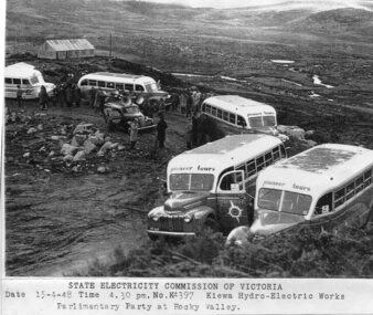
Photograph - Parlimentary Party visiting Rocky Valley Dam site, 15-4-1948
This photograph was taken during construction of the Rocky Valley Dam and wall. Work was commenced in early 1947 but had to be suspended during winter and then resumed in October. Work continued in 1948 with the establishment of work facilities and, at the dam site, the river was diverted through a temporary pipeline. Rocky Valley and associated spillway and outlet works were completed in 1959.A pictorial record of the construction of the rock and earth filled dam wall at Rocky Valley. Shows the extent of the project undertaken and the level of importance of the project as indicated by the large representation at the parliamentary party visit on 15/4/48.Photocopy of black and white photograph of parliamentary party visiting Rocky Valley Dam site 15/04/1948Typed on the bottom of photocopy - State Electricity Commission of Victoria. Date: 15-4-48 Time: 4.30pm No: K4397. Kiewa Hydro-Electric works. Parlimentary Party at Rocky Valleyrocky valley dam, parliamentary party, secv -
 Kiewa Valley Historical Society
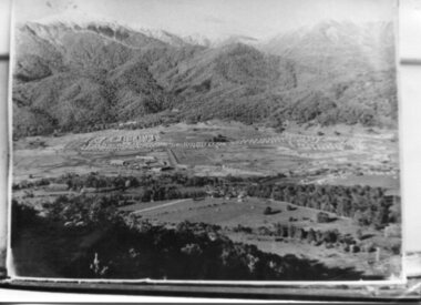
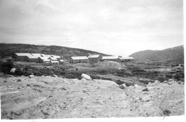
Photograph - Mt Beauty Camp, Estimated 1950-1951
... tunnel into the Kiewa River. Mt beauty camp SECV construction ...This photo is of the very newly constructed State Electricity Commission town of Mt. Beauty. The houses up to Nelse street were erected from 1946 onward and then the township was extended beyond Nelse Street in 1950 which places this photograph about 1950/51. There is no evidence of work being commenced on the regulating pondage but the tail race canal can be seen on the centre right of photo. The workmen's camp was enlarged in 1950 to the extent of providing accommodation for a total of 1,200. There are a number of dwellings on Simmonds Creek and the road to Falls Creek can clearly be seen. Snow capped Mt. Bogong is in the upper left of the photo with Mt. Beauty behind the township rising to Big Hill beyond that.Shows the newly constructed town of Mt. Beauty surrounded by farmland and before the regulating pondage was built to discharge water from the power stations via the West Kiewa tail race tunnel into the Kiewa River. Copy of black and white photograph of Mt Beauty CampWritten on the back in black ink - A Campenmt beauty camp, secv, construction town -
 Kiewa Valley Historical Society
Photographs x 2 - Afternoon tea visit to Towong Hill
Towong Hill Homestead is a 110-year-old Federation style mansion situated on a rock outcrop, with views of about 260 degrees. It was built over 2 years by grazier Walter Mitchell from bricks made from local clay dug from the river bank, to be the family home for his new bride Winifred. They established their home in 1904. After the death of Walter in 1917, Winifred relocated her family, but the homestead remained in the families hands. In 1935, Thomas Mitchell (1906-1984) returned home to Australia, a successful Lawyer, and married city girl, Elyne Chauvel, and settled himself back at his childhood home, Towong Hill. Thomas was a world champion slalom skier, had been a prisoner of the Japanese at Changi, and was elected for the Country Party in 1946 and served as attorney-general in the McDonald government. His wife Elayne (1913-2002) is best remembered for her Silver Brumby series of novels for children. But Elyne also wrote a substantial number of non-fiction works about the Snowy Mountains. Photographs demonstrate local Kiewa Valley residents enjoying a community visit to the historic homestead at Towong Hill which holds significance to the early history of the area. Also demonstrates a pictorial history of social activities undertaken during this period2 black and white photographs mounted on buff card. Kiewa Valley residents attending afternoon tea at Towong HillHandwritten in black pen underneath photo - T.W.Mitchell Towong Hill. Afternoon Teat w mitchell, towong hill, kiewa valley -
 Kiewa Valley Historical Society
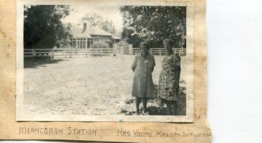
Photographs x 2- Khancoban Station and Comet the horse
In 1824, Hume and Hovell were the first Europeans to pass through the district and graziers soon followed, impressed by the abundance of fodder and water. The first cattle run in the area was settled in about 1838 in what was known as Swampy Plains. Later, this run became known as “Khancoban Station”. Khancoban lies in the heart of the high country and is home of Australia’s mountain cattlemen. This heritage is celebrated in Banjo Paterson’s epic poem, “The Man from Snowy River”. In 1962, Bruce and Jo Chisholm relocated from Bond Springs to Khancoban Station, which Bruce had acquired in 1959. Khancoban Hereford and thoroughbred stud progeny were keenly sought after whenever they were presented in the sale ring. Bruce imported a stallion, Comet, from England in 1964. Comet stood at Khancoban for 15 years and was the sire of numerous winners, including Cobbermine, Kelly's Eye, Boack and Starglow. Photographs demonstrate local Kiewa Valley residents enjoying a community visit to the historic homestead at Khancoban Station which holds significance to the early history of the area. Its heritage is celebrated in Banjo Paterson’s epic poem, “The Man from Snowy River”. Also demonstrates a pictorial history of social activities undertaken during this period Black and white photographs mounted on buff card 1. Kiewa Valley residents visiting Khancoban Station 2. Photo of thoroughbred horse Comet and handler at Khancoban Station1. Handwritten in black ink below photo- Khancoban Station. Mrs. Young, Mrs Van Der Weyde 2. Handwritten in black ink above photo- "Comet' at Khancobankiewa valley residents, clare roper -
 Kiewa Valley Historical Society
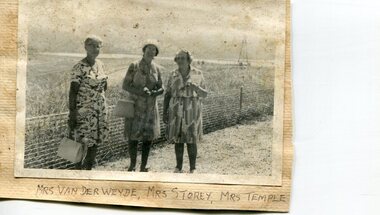
Photographs x 2- Groups of Kiewa Valley residents on tour of Khancoban area
... , “The Man from Snowy River”. Kiewa Valley residents Clare Roper 1 ...Demonstrates a pictorial history of social activities undertaken by Kiewa Valley residents during this period possibly 1970’s to 1980’s. Also a pictorial record of residents of the Kiewa Valley during this period. Photographs demonstrate local Kiewa Valley residents enjoying a community visit to the Khancoban area, which holds significance to the early history of the district. Its heritage is celebrated in Banjo Paterson’s epic poem, “The Man from Snowy River”. 2 black and white photographs mounted on buff card. 1. Group of ladies on a tour of the Khancoban area 2. Mixed group of ladies and men on a tour of the Khancoban area 1. Handwritten in black ink below photo 'Mrs Van Der Weyde, Mrs Storey, Mrs Temple 2. Handwritten in black pen below photo 'A.O. Smith, A. Angus, Mrs. Pullin, S. Ross, C. Roper, Mrs Temple, A. E. Campbell (name of last person obscured)kiewa valley residents, clare roper -
 Kiewa Valley Historical Society
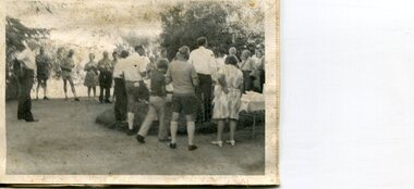
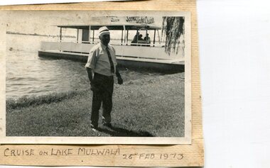
Photographs x 3- Cruise on Lake Mulwala, 25/2/1973
Lake Mulwala is a man–made reservoir created through the construction of the Yarrawonga Weir across the Murray River, is located between Bundalong and Yarrawonga in Hume region of Victoria and Mulwala in the Riverina region of New South Wales, in eastern Australia. The weir was constructed in 1939 to provide water for irrigation of the surrounding district. The weir also serves as a crossing of the Murray between the two towns. It is a popular tourist destination for boating, fishing and other water recreation.Photographs demonstrate local Kiewa Valley residents enjoying a visit to the picturesque area of Lake Mulwala. Also provides a pictorial history of 1973.3 black and white photographs mounted on buff card. Photographs of a cruise on Lake Mulwala 25th Feb. 1973 1. Photo of unidentified man standing on the shore of Lake Mulwala beside cruise launch. 2. Group photo of people standing by cruise boat as others disembark. Woman in centre holding handbag may be Clare Roper (unconfirmed) 3. Photo of 2 men aboard cruise launch looking out over Lake Mulwala1. Handwritten at bottom of photo in black ink. 'Cruise on Lake Mulwala. 25th Feb. 1973' 2. Painted sign above cruise launch- Scenic Lake Cruises 3. No markingsclare roper -
 Kiewa Valley Historical Society
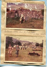
Photographs x 2- D Reids home at Mill Park 1973, 2/12/1973
David Reid (1820-1906) was a pastoralists and politician. He left school at 16 and after meeting the overlander John Gardiner he decided to look for land south of the Murray River. Equipped by his father with some 500 head of cattle, 2 bullock wagons and teams and 6 assigned servants, he reached the Ovens River on 8 September 1838. David settled at Currargarmonge, near Wangaratta. At the end of 1843 he took up land near Yackandandah. In 1847 he took up a section of the family run of which Woorajay (Wooragee) formed a part. He built the first water driven flour-mill in the district on his Yackandandah run in 1845; his woolclip of 1848 was one of the first to be handled by R. Goldsbrough and was claimed to come from sheep descended from stock imported in the 1820s from George III's flock. Going into politics, he held the Legislative Assembly seat of Murray from October 1859 to May 1862. David Reid was a highly regarded grazier and local politician who was significantly involved in settlement around the Yackandandah area. Photo demonstrates ongoing interest in the local history of the area and its early residents2 colour photographs mounted together on buff card 1. Man and 2 children (unidentified) standing outside the remains of the Reid home. 2 Dec, 1973 2. Group of unidentified people on a tour of the old homestead of D. Reid. 2 Dec, 19731. Handwritten in black ink under photo 'D. Reid's home 1845. At Mill Park. 2 Dec 1973 2. Handwritten in blue ink under photo 'Snapshots Clare Roper"clare roper -
 Kiewa Valley Historical Society
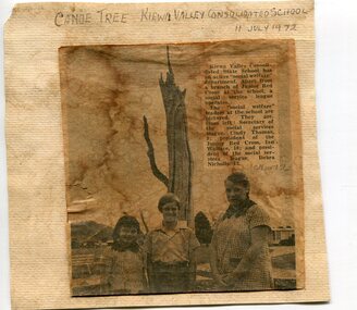
Newspaper clipping 11/7/72 Canoe tree in Kiewa & Photo-Tawonga Homestead
... for fishing in the rivers running through the Kiewa Valley either... the Kiewa River and indicates that Aborigines lived by the river ...1. Kiewa Valley Consolidated School was established in 1953 combining Dederang North, Kergunyah, Gundowring, Kiewa, Gundowring Upper, Red Bluff, Charleroi and Gundowing North schools on a 10 acre site with 11 rooms at Kiewa. The bark was cut from the canoe tree, by aboriginal craftsmen, to produce a canoe for fishing in the rivers running through the Kiewa Valley either before or just after the 1800's. The tree trunk, located at Kiewa, would have been used at the beginning of European settlement in the Kiewa Valley or just before contact was made. 2. Pictorial record of the graves of early pioneers C Ibbotson, Mrs Elizabeth Eyre and John Eyre who died between 1858 – 1904, all located at Tawonga Homestead 1. The above schools are in the Kiewa Valley. The date and number of combined schools give insight into the change in population and families in the Kiewa Valley before and after 1953. The tree was found along the Kiewa River and indicates that Aborigines lived by the river and used tree bark to craft canoes to cross rivers and to fish in the deeper sections of the river. 2. Pictorial record of the early history of Kiewa Valley pioneers whose descendants have lived and worked in the Kiewa Valley for many years 1. Newspaper article of local school children visiting a canoe tree in Kiewa July 11, 1972. mounted on buff card 2. Black and white photo of pioneer graves at old Tawonga Homestead. Mounted on buff card 1. Handwritten in black ink above newspaper clipping ‘Canoe Tree Kiewa Valley Consolidated School. 11 July, 1972’ Handwritten in pencil at bottom of article ’10 Nov. ‘72’ 2. Handwritten in black ink above photo ‘Tawonga Homestead graves’ Handwritten below photo ‘T Ibbotson D. 1858, Elizabeth Eyre D. 1879, John Eyre D 1879, John Eyre D. 1904 tawonga homestead, canoe tree at kiewa, tawonga graves -
 Kiewa Valley Historical Society
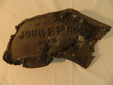
Roper's Hut Memorabilia
Roper's Hut was built in 1939 and was burnt down in 2003. It was rebuilt in 2008 and is situated on the Bogong High Plains on Duane Spur (where Duane's hut had been before it too was destroyed by (1939) bushfires, between Mt Nelse and Big River. The original hut was used as a shelter for cattlemen who grazed their cattle on the High Plains during summer. The Victorian High Country Huts Association Inc. members and friends helped rebuild the hut which is now used as an emergency shelter for visitors to the High Plains.The memorabilia is significant as the items belonged to the Roper family who were one of the original settlers of the Kiewa Valley and one of the original families who drove their cattle up to the Bogong High Plains. The burnt plaque and forks and the rebuilding of the huts (Duane's & Roper's) are significant as bush fires are a constant threat to the Bogong High Plains destroying large areas at a time.1. Bronze Plaque and 2 damaged forks from Roper's Hut which was destroyed by bush fires in 2003. 2. DVD & USB and hard copy photos of the rebuild of Roper's Hut in January 2008.The plaque had 'In Memory of / John F. P. Roper/ died 3-12-1977 / Aged 78 years / He built the original hut Feb. 1939'roper's hut, cattlemen, bogong high plains, bronze plaque, roper family, bush fires -
 Kiewa Valley Historical Society
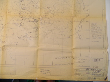
Plan - Kiewa Scheme General Plan 1958, S.E.C.V. Design & Construction Dept. Civil Branch, Dec. 1958
The Kiewa Hydro Electric Scheme was constructed by the State Electricity Commission of Victoria. Draftsmen drew up the plan of the layout as per the instructions from the engineers. The plan was drawn up on a transparency sheet and paper prints run off on a 'dyeline' copier. The 'Chief draftsman' and 'Design engineer' and 'Civil engineers recommended it and approved it. Historic: This plan gives a time line for the work on the Kiewa Hydro Electric Scheme. It is a good example of the work of a draftsman and the copying process in 1958.Large topography map of the area covered by the Kiewa Hydro Electric Scheme in 1958. Mountain peaks are marked in red and named. Rivers, roads, construction infrastructure as well as the main areas / names of construction are named. Signed and dated by employees of the S.E.C.V. working on the scheme.state electricity commission of victoria., kiewa hydro electric scheme, plan, engineer, draftsman -
 Kiewa Valley Historical Society
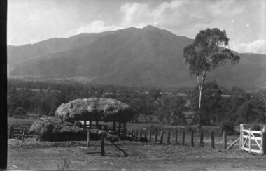
Four photographs of the Blue Duck Hotel and two Photos of the Glen Wills area, c1920 Post cards, c1949/50 small photographs
The Blue Duck Hotel stands at the confluence of 3 trout rivers - Cobungra, Bundarra and Mitta Mitta, called Angler's Rest. The original 1900's building was of slab construction and operated as a butcher shop, servicing miners on the track from Omeo to Mt. Wills. In 1912 it was purchased by a miner, Billy O'Connell, and he obtained a hotel license. In the early 1920's he transported 2 houses from Omeo on Horse drays. One is the main building of the Blue Duck and the other was a residence where Billy and his wife raised their nine children. The small log structure behind the pub is State School No.4286 where the children attended school. A teacher was shared with Glen Wills. By the late 1920's the hotel was discovered and patronized by keen anglers. Sir Harold Clapp (head of the railways) was one and he had the bronze blue duck cast and presented to the owners in the 1930's. This stands at the entrance to the premises.These photographs are of a building, in a remote area, that has provided a service to miners, anglers and travellers for over 100 years and continues to do so today. It also played a vital role in the history of the Mt. Wills/Omeo gold mining days.3 Post cards, Black and White photographs. 3 small black and white photographsPost Card No. 1 - "Blue Duck Hotel- Omeo-Glen wills road Ray Love Series No.2"(written on lower front) Post Card No. 2- "Looking towards Bogong High Plains. Omeo-Glen Wills road"(front, bottom, L hand) Ray Love Series No. 18 (front, lower R hand corner) On both of above photos, centre back, is stamped POST CARD and underneath this is printed "A GENUINE PHOTOGRAPH'/ Post Card No. 3 - Bottom L hand corner "Mystic Sea Australian Alps". R hand corner "(Bulmer Copyright)". Each small photograph, handwritten on back "Blue duck Hotel". All have circular stamp with "Print by Wilson White Albury" blue duck hotel; anglers rest; omeo highway; fishing; mining -
 Kiewa Valley Historical Society
11 Black and White photographs of the Rocky Valley area, c1948
In October 1947 construction was commenced on the erection of the workmen's camp at Rocky Valley. Also in 1947 construction of a stream diversion was commenced to allow excavation to commence for the dam wall. In the summer of 1948/49, stripping of the foundation area on both sides of the river was carried out. Weather conditions were not always favourable during the construction, particularly 1955/56 summer, and work would have to cease each year for the winter season due to the severe conditions. The dam is a earth and rock fill structure with a height of about 30.5 metres and crest length 518.16 metres and was completed in March, 1959.These photographs show the type of terrain in the area prior to the construction and filling of Rocky Valley Dam. Also of interest is the type of accommodation provided for those working on the construction and the early cranes available in the 1940/50's. Of historical importance to understand the conditions in the early construction of the Kiewa Hydro Electric SchemeEleven small black and white photographsPhoto No. 1 - on the back, printed in ink"Rocky Valley - New Mess & offices Dec. 1948". In pencil '14 on the back Photo No. 2 - on the back, printed in ink "Rocky Valley Camp. October 1948". Also stamped on the back "998L" Photo No. 3 -on the back, printed in ink "Rocky Valley Hostel October 1948". Also stamped on the back '998L' Photo No. 4 - on the back, printed in ink "Spion Kopje from bedroom window. October 1948". Stamped on the back '998L'. Photo No. 5 - on the back, printed in ink "Rocky Valley Basin Dec. 1948." In pencil on back, 14. Photo No. 6 - on the back, printed in ink "Site of Wall for Rocky Valley Dam Dec. 1948". In pencil on back, 14. Photo No. 7 - On the back, printed in ink "Commencing of Diversion Tunnel Rocky Valley December 1948". In pencil on back, 14. Photo No. 8 - on the back, printed in ink "One of the two electric cranes at Rocky Valley December 1948". In pencil on back, 14. Photo No. 9 - on the back, printed in ink "'Rapier' (H.Y.) electric crane Rocky Valley December 1948". In pencil on back, 14 . Photo No. 10 - on the back, printed in ink " Pretty Valley Pump line construction Mt. Cope in Background Nov 1948. Circular stamp with the words 'print by Wilson White Albury' in the circle. Photo No. 11 - on the back, printed in ink "Stringing cable on Ruined Castle October 1948. Same stamp as No. 10. In pencil '31'. rocky valley; pretty valley; ruined castle; bogong high plains; kiewa hydro electric scheme -
 Kiewa Valley Historical Society
18 small black and white photographs of the Bogong High Plains, 1948
These photos of the Bogong High Plains were all taken by Ronald George Thorn who was a cadet engineer with the State Electricity Commission. He worked on the Kiewa scheme from 1948 to 1950 doing overhead line construction and maintenance plus electrical design and drawing work. They are from his personal collection and a record of his time in the Kiewa area.Pictorial history of personal involvement in the the early days of the Kiewa Scheme.18 small black and white photographs all taken on the Bogong High Plains.Photo 1 Wallace's Hut. Photo 2 Ruined Castle - Looking towards Pretty Valley December 1948. Photo 3 Ruined Castle - Looking towards Pretty Valley December 1948. Photo 4 Ruined Castle - Looking Down Valley December 1948. Photo 5 - Mt. McKay from Ruined Castle October 1948. Photo 6 View from Rocky Valley Camp October 1948. Photo 7 Mt. Feather Top from Ruined Castle October 1948. Photo 8 View from Ruined Castle looking downwards towards Beauty October 1948. Photo 9 Rocky River from gauging station October 1948. Photo 10 Rocky Valley River from main road October 1948. Photo 11 View along little Arthur Fire Track October 1948. Photo 12 View along main road. Looking towards Beauty Valley October 1948. Photo 13 View from Little Arthur Fire Track October 1948. Photo 14 Frying Pan Spur from Rocky Valley Road October 1948. Photo 15 Mt. Bogong from Big Hill Fire Track October 1948. Photo 16 View from Big Hill Fire Track October 1948. Photo 17 Mt. Feathertop from Ruined Castle October 1948. Photo 18 Mt. Fainter from Ruined Castle October 1948. (All of the above is hand written on the back of photos in ink). bogong high plains; r g thorn; secv; kiewa hydro electric scheme; pictorial history -
 Kiewa Valley Historical Society
Photograph - Folder of Photographs – Photocopied set of black and white photographs (pages 9 - 18) from the display folder put together by KVHS to document life on the Kiewa Valley Hydro-electric Scheme
... of the Kiewa River. These new ‘towns’ such as Mt Beauty and Bogong ...Although the Kiewa Hydro-Electric Scheme was first proposed in 1911, construction did not commence until 1938. As part of the push to cut electricity costs and diversify supply, the Victorian Government (circa 1930) initiated the conversion from primarily brown coal supply to hydro – electricity. Field investigations during the 1940’s resulted in a new proposal for a scheme that had more than double the capacity of the 1938 scheme. The Kiewa Hydroelectric Scheme became the largest scheme of its kind in the State Of Victoria and the second largest scheme in Australia. The number of personnel involved in the planning and construction of the scheme increased dramatically. During the late 1940’s, most activity centred around the construction of the West Kiewa Power Station, Rocky Valley Reservoir, McKay Creek Power Station and the Bogong Creek Aqueduct.A common thread across all the larger hydro scheme constructions was the need for workers, both qualified and unqualified who came from around the world seeking a new life for themselves and their families. New accommodation and facilities were required for the army of workers engaged in construction in often remote and wild areas. The SEC had a high demand for timber, and set up the first of a number of sawmills at Bogong Creek in 1939 and set up the first hardwood logging in the headwaters of the Kiewa River. These new ‘towns’ such as Mt Beauty and Bogong, survived, serving the needs of operational personnel and their families, and expanding with growth of new industries. Mount Beauty, and to a lesser extent Bogong, are among these places. PHYSICAL: Large A3 size spiral bound display folder containing 21 pages of photocopied black and white photographs of various aspects of the early days of the Kiewa Valley Hydro-electric scheme including equipment, various work sites and photographs of workers and their families. 1-Bridge across Tailrace Channel 1946 2-New Mess building, Mt Beauty 3-Homan’s Gap Saw Mill 4- Diamond Drilling Plant – Big Hill 5-Rocky Valley Camp-Mess Building 6-Parlimentary Party at Rocky Valley 7-No.4 Headrace Tunnel 8- Allis-Chalmers Tractor School 9- SECV Heavy Machinery lined up by road 10- No. 5 Raceline – Balasting Track with improvised truck 1-1946 – Bridge across tailrace channel Page number 9 2-New mess building, Mt Beauty 6.4.46 Page number 10 3- STATE ELECTRICITY COMMISSION OF VICTORIA Date: 10.1.47 Time: 11.40am No K2271 Kiewa Hydro Electric Works Homan’s Gap Saw Mill – Rip Saw Page number 11 4- STATE ELECTRICITY COMMISSION OF VICTORIA Date: 5.10.47 Time: 11am No K4111 Kiewa Hydro Electric Works Diamond Drilling Plant – Big Hill Page number 12 5- STATE ELECTRICITY COMMISSION OF VICTORIA Date: 11.2.48 Time: 3pm No K4277 Kiewa Hydro Electric Works Rocky Valley Camp-Mess Building Page number 13 6- STATE ELECTRICITY COMMISSION OF VICTORIA Date: 15.4.48 Time: 4.30pm No K4397 Kiewa Hydro Electric Works Parlimentary Party at Rocky Valley Page number 14 7- STATE ELECTRICITY COMMISSION OF VICTORIA Date: 22.8.48 Time: 9am No K4668 Kiewa Hydro Electric Works General view of No.4 Headrace Tunnel Page number 15 8-STATE ELECTRICITY COMMISSION OF VICTORIA Date: 5.9.49 Time: 10am No K5180 Kiewa Hydro Electric Works Allis-Chalmers Tractor School – HD 19, Mr I Crossthwaite at Controls Page number 16 9- No markings Page number 17 10- STATE ELECTRICITY COMMISSION OF VICTORIA Date: 7,12.49 Time: 4pm No K5423 Kiewa Hydro Electric Works No. 5 Raceline – Balasting Track with improvised truck. Page number 18 secv; kiewa hydro electric scheme; mt beauty; bogong; construction area -
 Kiewa Valley Historical Society
Photograph - Folder of Photographs – Photocopied set of 10 black and white photographs (pages 19 - 28) from the display folder put together by KVHS to document life on the Kiewa Valley Hydro-electric Scheme
... of the Kiewa River. These new ‘towns’ such as Mt Beauty and Bogong ...Although the Kiewa Hydro-Electric Scheme was first proposed in 1911, construction did not commence until 1938. As part of the push to cut electricity costs and diversify supply, the Victorian Government (circa 1930) initiated the conversion from primarily brown coal supply to hydro – electricity. Field investigations during the 1940’s resulted in a new proposal for a scheme that had more than double the capacity of the 1938 scheme. The Kiewa Hydroelectric Scheme became the largest scheme of its kind in the State Of Victoria and the second largest scheme in Australia. The number of personnel involved in the planning and construction of the scheme increased dramatically. During the late 1940’s, most activity centred around the construction of the West Kiewa Power Station, Rocky Valley Reservoir, McKay Creek Power Station and the Bogong Creek Aqueduct.A common thread across all the larger hydro scheme constructions was the need for workers, both qualified and unqualified who came from around the world seeking a new life for themselves and their families. New accommodation and facilities were required for the army of workers engaged in construction in often remote and wild areas. The SEC had a high demand for timber, and set up the first of a number of sawmills at Bogong Creek in 1939 and set up the first hardwood logging in the headwaters of the Kiewa River. These new ‘towns’ such as Mt Beauty and Bogong, survived, serving the needs of operational personnel and their families, and expanding with growth of new industries. Mount Beauty, and to a lesser extent Bogong, are among these places. Large A3 size spiral bound display folder containing 21 pages of photocopied black and white photographs of various aspects of the early days of the Kiewa Valley Hydro-electric scheme including equipment, various work sites and photographs of workers and their families. 1-Allis Chalmers Tractor School 2- Gardens outside Administrative Office – Mt Beauty 3- Mt Beauty house – 1950 4-Bridge over Pretty Valley River, Bogong 5-Rocky Valley Spillway Tunnel break through 6-Ni 1 Headrace Tunnel drilling face 7-No 4 Power Station Drilling 8-Clover Dam Flood Waters 9-No1 Head Race Tunnel Portal Building 10-Clover Dam 1-STATE ELECTRICITY COMMISSION OF VICTORIA Date: 5.9.49 Time: 10amm No K5174 Kiewa Hydro Electric Works Allis Chalmers Tractor School Page number 19 2-STATE ELECTRICITY COMMISSION OF VICTORIA Date: 22.2.50 Time: 3.30pm No K5601 Kiewa Hydro Electric Works Gardens outside Administrative Office – Mt Beauty Page number 20 3-Mt Beauty house – 1950 Page number 21 4-STATE ELECTRICITY COMMISSION OF VICTORIA Date: 23.10.50 Time: 11.15am No K6331 Kiewa Hydro Electric Works Bogong-Bridge over Pretty Valley River Page number 22 5-STATE ELECTRICITY COMMISSION OF VICTORIA Date: 23.6.50 Time: 2.30pm No K5844 Kiewa Hydro Electric Works ROCKY VALLEY SPILLWAY TUNNEL BREAK THROUGH Page number 23 6-20/3/52 – No. 1 Headrace Tunnel Drilling face (E.E.E. contract) Page number 24 7-6/6/52 – No 4 Power Station – Drilling Page number 25 8-STATE ELECTRICITY COMMISSION OF VICTORIA Date: 6/6/52 Time: No K7113 Kiewa Hydro Electric Works Clover Dam Flood Waters Page number 26 9-STATE ELECTRICITY COMMISSION OF VICTORIA Date: Oct 1952 Time: No K7239 Kiewa Hydro Electric Works No. 1 HEAD RACE TUNNEL PORTAL BUILDING. Handwritten underneath – This information from Ron White-the later Principal Hydro Engineer of the SEC. Oct 1952 Location incorrect? All work on No 1 had ceased after financial crash of 1951. This photo would refer to No 4 Headrace Tunnel? Page number 27 10-STATE ELECTRICITY COMMISSION OF VICTORIA Date: Jan 1953 Time: No K7307 Kiewa Hydro Electric Works CLOVER DAM Page number 28 secv; kiewa hydro electric scheme; bogong; mt beauty; construction area -
 Kiewa Valley Historical Society
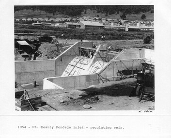
Photograph - Folder of Photographs – Photocopied set of 10 black and white photographs (pages 29 - 38) from the display folder put together by KVHS to document life on the Kiewa Valley Hydro-electric Scheme
... of the Kiewa River. These new ‘towns’ such as Mt Beauty and Bogong ...Although the Kiewa Hydro-Electric Scheme was first proposed in 1911, construction did not commence until 1938. As part of the push to cut electricity costs and diversify supply, the Victorian Government (circa 1930) initiated the conversion from primarily brown coal supply to hydro – electricity. Field investigations during the 1940’s resulted in a new proposal for a scheme that had more than double the capacity of the 1938 scheme. The Kiewa Hydroelectric Scheme became the largest scheme of its kind in the State Of Victoria and the second largest scheme in Australia. The number of personnel involved in the planning and construction of the scheme increased dramatically. During the late 1940’s, most activity centred around the construction of the West Kiewa Power Station, Rocky Valley Reservoir, McKay Creek Power Station and the Bogong Creek Aqueduct.A common thread across all the larger hydro scheme constructions was the need for workers, both qualified and unqualified who came from around the world seeking a new life for themselves and their families. New accommodation and facilities were required for the army of workers engaged in construction in often remote and wild areas. The SEC had a high demand for timber, and set up the first of a number of sawmills at Bogong Creek in 1939 and set up the first hardwood logging in the headwaters of the Kiewa River. These new ‘towns’ such as Mt Beauty and Bogong, survived, serving the needs of operational personnel and their families, and expanding with growth of new industries. Mount Beauty, and to a lesser extent Bogong, are among these places. Large A3 size spiral bound display folder containing 21 pages of photocopied black and white photographs of various aspects of the early days of the Kiewa Valley Hydro-electric scheme including equipment, various work sites and photographs of workers and their families. 1-Mt Beauty Pondage inlet-Regulating weir 2-Langfords Gap Basalt Hill-Tunnel in quarry face.3-Rocky Valley Camp-from Engineering Office 4-Basalt Hill tunnel portal 5-No 1 Pressure Shaft Works Bench 6-No 1 Power Station 7-Overturned haulage wagons on the side of an embankment 8- Group of workers dressed in wet weather gear inside a tunnel 9-Workmen and vehicle in tunnel 10-Howman’s Gap campsite at 4,150 feet 1-1954 – Mt Beauty Pondage inlet – Regulating weir Page number 29 2-28/10/54 – Langfords Gap Basalt Hill – Tunnel in quarry face K7860 Page number 30 3-STATE ELECTRICITY COMMISSION OF VICTORIA Date: 17.8.55 Time: No K8132 Kiewa Hydro Electric Works ROCKY VALLEY CAMP – FROM ENGINEERING OFFICE Page number 31 4-28/10/54 – Basalt Hill tunnel portal K7859 Page number 32 5-No.1 Pressure Shaft Works Bench 5.7.56 Page number 33 6- No. 1 Power Station 26.4.59 Page number 34 7- No markings Page number 35 8-No markings (Wooden board on ground printed with - POLAR A.N.GELATINE DYNAMITE “75” DE 28.8.40) Page number 36 9-No markings Page number 37 10-Howman’s Gap campsite at 4,150 feet Page number 38 secv; kiewa hydro electric scheme; mt beauty; bogong; construction area -
 Kiewa Valley Historical Society
Photograph - Folder of Photographs – Photocopied set of black and white photographs (pages 49 -58) from the display folder put together by KVHS to document life on the Kiewa Valley Hydro-electric Scheme
... of the Kiewa River. These new ‘towns’ such as Mt Beauty and Bogong ...Although the Kiewa Hydro-Electric Scheme was first proposed in 1911, construction did not commence until 1938. As part of the push to cut electricity costs and diversify supply, the Victorian Government (circa 1930) initiated the conversion from primarily brown coal supply to hydro – electricity. Field investigations during the 1940’s resulted in a new proposal for a scheme that had more than double the capacity of the 1938 scheme. The Kiewa Hydroelectric Scheme became the largest scheme of its kind in the State Of Victoria and the second largest scheme in Australia. The number of personnel involved in the planning and construction of the scheme increased dramatically. During the late 1940’s, most activity centred around the construction of the West Kiewa Power Station, Rocky Valley Reservoir, McKay Creek Power Station and the Bogong Creek Aqueduct.A common thread across all the larger hydro scheme constructions was the need for workers, both qualified and unqualified who came from around the world seeking a new life for themselves and their families. New accommodation and facilities were required for the army of workers engaged in construction in often remote and wild areas. The SEC had a high demand for timber, and set up the first of a number of sawmills at Bogong Creek in 1939 and set up the first hardwood logging in the headwaters of the Kiewa River. These new ‘towns’ such as Mt Beauty and Bogong, survived, serving the needs of operational personnel and their families, and expanding with growth of new industries. Mount Beauty, and to a lesser extent Bogong, are among these places. Large A3 size spiral bound display folder containing photocopied black and white photographs of various aspects of the early days of the Kiewa Valley Hydro-electric scheme including equipment, various work sites and photographs of workers and their families. 1-Workmen working inside one of the tunnels. 2-Workman drilling in West Kiewa Tunnel 3-Junction Dam wall construction 4&5-2B&W photographs Kiewa House residents ready to go to a ball in Mt Beauty 6-Workmen warming up in front of a fire at No 1 bench 7-Workmen being hauled in at No 4 P.S Shaft 8-No 4 Power Station – Drilling 9-Workmen eating a hot meal in the tunnel. 10-2 photographs (a)Pretty Valley camp showing workman’s huts and construction materials & (b)Worker in Langford Gap Basalt Hill Tunnel face 11-Tunnel entrance (unlabelled) with rail tracks in foreground 12- Workmen drilling at No 1 Head race tunnel-Drilling face 13- No 1 Power Station 14-Workmen at the entrance to one of the SECV tunnels under construction 1-SECV number at bottom of picture Half obscured possibly K8461 Page number 53 2-In West Kiewa Tunnel Page number 54 3- Construction of Junction Dam wall – approximately 1941 Page number 55 4&5- Residents of Kiewa House at Bogong ready to go to the ball at Mt Beauty-1946. Handwritten on a copy of the photo on opposite page Mrs Lorna Crosset filled out the names *Dad was Des Crossett – his daughter is Gael Petcopoulis Greta engaged to John broke it off. Charlie, Rosalind, Bill, Priscilla, Max Lawrence-Dad’s Boss, Mary & Max married, Mary, Kay, Gwen McPherson Mum’s boss, John McCluskey (c) At No. 5 Bench Page number 56 6- STATE ELECTRICITY COMMISSION OF VICTORIA Date: 27.2.51 Time:2.15pm No K6373 Kiewa Hydro Electric Works No. 4 P.S. Shaft – Haulage of men in buckets (b) As above Handwritten at top of photo Appendix 4 page number 57 7- STATE ELECTRICITY COMMISSION OF VICTORIA Date: 6.6.52 Time:… No K7122 Kiewa Hydro Electric Works No. 4 POWER STATION – DRILLING page number 58 8-No markings page number 59 9-(a)Handwritten under photograph Approx. 1948/49 (b) STATE ELECTRICITY COMMISSION OF VICTORIA Date: 28.10.54 Time:.. No K7860 Kiewa Hydro Electric Works LANGFORD GAP BASALT HILL TUNNEL FACE Page number 49 10-(a) No markings 11- STATE ELECTRICITY COMMISSION OF VICTORIA Date: 20.3.52 Time: No K6979 Kiewa Hydro Electric Works No. 1 HEAD RACE TUNNEL – DRILLING FACE (E.E.E. CONTRACT) ‘The Frenchies’ (E.E.E) as they were affectionately known Page number 50 12-31.5.56 No. 1 Power Station Aggregate Stock Piles. Page number 51 13&14-No markings Page number 52 secv; kiewa hydro electric scheme; bogong; mt beauty; construction area -
 Kiewa Valley Historical Society
Photograph - Folder of Photographs – Photocopied set of black and white photographs (pages 39 - 48) from the display folder put together by KVHS to document life on the Kiewa Valley Hydro-electric Scheme
... of the Kiewa River. These new ‘towns’ such as Mt Beauty and Bogong ...Although the Kiewa Hydro-Electric Scheme was first proposed in 1911, construction did not commence until 1938. As part of the push to cut electricity costs and diversify supply, the Victorian Government (circa 1930) initiated the conversion from primarily brown coal supply to hydro – electricity. Field investigations during the 1940’s resulted in a new proposal for a scheme that had more than double the capacity of the 1938 scheme. The Kiewa Hydroelectric Scheme became the largest scheme of its kind in the State Of Victoria and the second largest scheme in Australia. The number of personnel involved in the planning and construction of the scheme increased dramatically. During the late 1940’s, most activity centered around the construction of the West Kiewa Power Station, Rocky Valley Reservoir, McKay Creek Power Station and the Bogong Creek Aqueduct.A common thread across all the larger hydro scheme constructions was the need for workers, both qualified and unqualified who came from around the world seeking a new life for themselves and their families. New accommodation and facilities were required for the army of workers engaged in construction in often remote and wild areas. The SEC had a high demand for timber, and set up the first of a number of sawmills at Bogong Creek in 1939 and set up the first hardwood logging in the headwaters of the Kiewa River. These new ‘towns’ such as Mt Beauty and Bogong, survived, serving the needs of operational personnel and their families, and expanding with growth of new industries. Mount Beauty, and to a lesser extent Bogong, are among these places. Large A3 size spiral bound display folder containing photocopied black and white photographs of various aspects of the early days of the Kiewa Valley Hydro-electric scheme including equipment, various work sites and photographs of workers and their families. 1-Breakdown in Circuit Breaker (Isolating Contacts) 2-Big Hill Bench- Site of No 5 Devlopment 3-No 1 Power Station 4-No 1 Pipeline, Anchor No 8 5-Push Dozing-RD8 Tractor 6- Tractor and driver at work 7- Workmen in unnamed tunnel 8- Front page of Journal of SECV Vol 15. Photograph of No 1 pipeline viewed from McKay Portal 9-Rocky Valley Dam Core Wall 10-Workmen working inside tunnel loading rocks into a rail truck. 1-Breakdown in (generator) Circuit Breaker (Isolating Contacts) Handwritten underneath (This is not a picture of any part of a generator. It is a circuit breaker Signed Ron White Ron was the Principal Hydro Engineer of the SEC Kiewa Scheme Page number 39 2-Big Hill Bench – Site of No. 5 Development (abandoned) Page number 40 3-No 1 Power Station Page number 41 4-No. 1 Pipeline, Anchor No. 8 Page number 42 5-Push Dozing – RD8 Tractor, 12 cubic yard Carryall and FD Cletrac Tractor Page number 43 6-No marking Page number 44 7-No marking Page number 45 8-Journal of State Electricity Commission of Victoria SEC Vol 15 No… April-May, 19… No 1 Pipeline-A view from McKay Portal G Hempenstall and D Sutton stiffening pipe section for transport during construction (….indicates missing text) Page Number 46 9-Rocky Valley Dam Core Wall Page number 47 10-No markings Page number 48 secv; kiewa hydro electric scheme; construction area; power stations; reservoirs; aqueduct; mt beauty; bogong -
 Kiewa Valley Historical Society
Photographs – Set of 4 black and white photographs. One of a wooden church and three of rural homes and farmland. Area not identified
Europeans arrived in the Kiewa and Ovens Valleys in the 1830's and 40's. Following the drought of 1838-44, seeking out the rich pastures in the fertile Valleys. It proved to be perfect conditions for dairy farming and the raising of cattle. Miners Cottages and other similar wooden structures were a common sight in the area as they were a modest form of accommodation for their period, were quick to erect and economical as they made use of locally available building materials such as local timbers.These photographs provide a snapshot into the early dwellings and architecture of the Kiewa and Ovens Valley regions, including buildings such as the church, which provided an important gathering place for social interaction, especially in these isolated areas.1-Wooden church building with no identification. Large tree in the foreground in front of church 2&3- Black and white photographs of farmland and assorted dwellings, mostly miners style cottages in a valley with mountains in the background. A bridge with wooden railings is visible over the river in the middle of the photograph, also a more modern dwelling is visible in the north east of the photograph close to the river. 4-Black and white photograph of residential homes and farmland with an unsealed road running through the middle. Foreground shows a field which has been semi cleared of trees (stumps remaining). In the background are larger farming properties with the road disappearing into the distant hills. This might be Old Tallangatta before the town was moved in 1956. 1-3 - No inscriptions 4- Signature written on back in lead pencil - Sandra Templebuildings; church; farmland -
 Kiewa Valley Historical Society
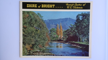
Brochure - Shire of Bright, Shire of Bright Tourist Centre of N.E. Victoria, Pre 1966
Bright and the surrounding towns were developing a large tourism industry which the Shire of Bright continues to promote, encouraging tourists to visit throughout the year. This high quality brochure has magnificent photos with a map showing the area and the distance (in miles) from the centre - the township of Bright.This brochure is promoting the Shire of Bright encouraging tourism in the area. This is important for the Shire as tourism is the main industry for the Shire. It is interesting to see how tourism has changed (or not) in the area.14 pages on glossy paper including colored and black and white photos. The front cover has the title at the top with yellow print on black background. Below the title is a large colored photo of a river, autumn trees and mountain. The back cover is a large colored photo of a man amongst the snow gums in the snow. The towns covered are Bright, Wandiligong, Eurobin, Mt Buffalo, McKay Creek Power Station, The Kiewa Hydro Electric Scheme, Mt Beauty, Kiewa, Bogong including tourist destinations in these areas and their surrounds.tourism; mt beauty; the kiewa valley; bright shire -
 Kiewa Valley Historical Society
Calendar 2008
Brief history of the SECV construction town of Bogong which became a tourist town."Memories of Bogong Calendar 2008" Photographs of the physical environment. Front cover has a photograph of a person standing in a river. A short history of 'Bogong 1957-1963' and 'Come visit Bogong Village' a 'celebration of Bogong Village's environment'. 12pp with a hole (to hang up) in the centre bottombogong, calendar, tourism, bogong village, secv, kiewa hydro electric scheme -
 Kiewa Valley Historical Society
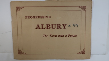
Book - Albury, NSW, Progressive Albury The Town with a Future
Albury is in NSW on the Murray River across the border from Wodonga. From 1839 it has grown and has a population of c8000 in 1919. Many of its buildings are grand and include 'Mates' a 'progressive up-to-date' Department Store.Residents of the Kiewa Valley shop in Albury and Wodonga as together these are their closest main cities.Cream cardboard cover with reddish print inside rectangular border with grape decoration in each corner. 20 pages held by 2 staples. Each page has 1 or 2 black and white photos. Photos have their title printed underneath.On cover - "in 1919"albury, shopping, murray river, mates department store, grand buildings -
 Kiewa Valley Historical Society
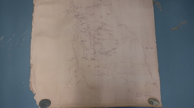
Map - Bogong High Plains
Bogong high Plains showing mountains, places, roads and riversHistorical changes of infrastructure on the Bogong High PlainsBogong High Plains, hand written and 'copied with considerable simplification from F.C.V. (Falls Creek V.?) 'Feathetop' L 'Tawonga'. Paper is yellowed, writing is brown.bogong high plains map