Showing 576 items
matching city planning -- victoria
-
 Glen Eira Historical Society
Photograph, Dalny Road, 13, Murrumbeena, 2001
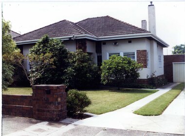
Originally labelled "Beauville Estate, Established 1936, Still Thriving 65 years on, 10th March 2001", the Beauville Estate Album contains colour photographs of houses in the Estate. They were taken around the time of the Beauville Estate’s 65th Heritage Celebration held on 10/03/2001 and donated to the Caulfield Historical Society shortly afterwards. Photographer unknown. City of Glen Eira’s Heritage Management Plan Vol 2 p79 (this is p84 of the pdf version) – HO12 Beauville Estate and environs, Murrumbeena: The Beauville Historic Area is important at the State level as the first large housing estate undertaken by the AV Jennings Construction Co, later Jennings Group Limited, Victoria’s largest home builder. It is important also as a very early estate development incorporating a range of features other than houses and including made roads, shops and recreation facilities. In this respect it was the forerunner of the comprehensively planned housing estate of the post war era. The estate is distinguished by its aesthetic values, as is the earlier and comparable Hillcrest Estate, which are formed by a combination of restrained diversity in house styles, with the exception of no. 30 in the emerging International style, and by a landscaped garden environment. Colour photograph of a white rendered brick house with decorative unpainted variegated brown brick features including a panel and column. Other features include tiled roof, porch, 2 tall rendered chimneys, concrete driveway, variegated brown brick garage with white door and a low unpainted matching brick fence in the foreground with established bushes and lawn behind.13murrumbeena, houses, architectural styles, 1930's, inter war style, a.v. jennings, av jennings, jennings, brick houses, beauville estate, dalny road, sir albert victor jennings, a v jennings construction co, beauville estate heritage area, glen eira city council, architectural features, jennings group limited, land subdivision, gardens, beauville historic area, rendered houses, brick features, porches, chimneys, garages (private), brick fences -
 Glen Eira Historical Society
Letter - ELSTERNWICK POST OFFICE
This file contains seven items about the significance of this building and how this was established : 1/ Photocopies of a handwritten application (in duplicate) by Walter Kay of Elsternwick dated 13/10/1985 and Rodney H Bush’s dated 16/10/1985 to the Historic Buildings Council to register the former Elsternwick Post Office building, and an original typewritten letter dated 17/10/1985 from the Historic Buildings Council to Caulfield and Historic Society advising them of an application and inviting them to submit relevant information about the building with a copy of application attached. 2/ Six pieces of correspondence between various interested parties (Caulfield Council , Caulfield Historical Society, National Trust, of Australia and Ministry for Planning and Environment on behalf of Historic Buildings Council, Victoria) about the significance of the former Elsternwick Post Office building and the progress of efforts to include it on the Register of Historic buildings. Dated between November 1985 and May 1986. 3/ Two pieces of correspondence between the Caulfield Progress Association and the Caulfield Historical Society dated April and May 1986, regarding the efforts of the Historical Society to save the former Elsternwick Post Office building. 4/ Two pieces of ephemera by the Caulfield Progress Association, one original undated and one photocopy undated in 1986. Both appealing to the public for support to help the former Elsternwick Post Office building and to protest a proposal to demolish it, by Caulfield Council. 5/Original newspaper article dated 07/06/1989 from the Malvern-Caulfield Progress newspaper written by Robert Carmody. The article talks about the approval by the Historic Buildings Council of Caulfield Council’s restoration program of the former Elsternwick Post Office building worth approximately $850,000. The refurbishment would consist of a shop and office space which would then be rented out. Mayor Emil Braun outlines the progress to implement the plans. 6/ Caulfield Conservation Study by Andrew Ward dated September 1994 of former Elsternwick Post Office Building. The building plans for the Elizabethan Style building were approved in 1891. The original timber verandahs were replaced by the present brickworks in circa 1918 rear extensions in 1941-42. Similar Post Offices were built at Kew, Queenscliff and Portarlington. 7/ Computer printout dated 19/03/2010 of Statement of Significance held by the Victorian Heritage database of the former Elsternwick Post Office Building. It was built in 1891 in the ‘Queen Anne’ style. The substantial two story red brick building was set on a bluestone plinth with an ornate façade incorporating cement dressings. There is a brief summary of the settlement and development of the Elsternwick area with mention of how important the building is to the Elsternwick Community. Original date and author is unknown.elsternwick post office, glenhuntly road, elsternwick, riddell parade, office buildings, postal services, caulfield city council, kay walter, regent street, caulfield, bush rodney h, gisborne street, city of caulfield, braun emil councillor, mayors, aylen doug, aylen douglas r, historic buildings council, caulfield historical society, ministry for planning and environment, head stephen, historic buildings act 1981, anderson p, national trust of australia (victoria), public works department, architectural styles, calder g.k. councillor, wills cathie, lyall kerry, marsden john hudson, town clerk, hill douglas, caulfield progress association, caulfield south, glen eira road, hawthorn road, mac neil j.r., neville street, glenhuntly, marten veronika, ballantyne richard, royal historical society of victoria, dunstan don, alfada street south, hardy joan, baird rob, snowball betty, ward andrew, hoddle robert, foot henry, ebden charles hodson, elster, oldham mary kate, english ‘queen anne’ revival style, rifle club, coulson herbert h., fick p.g., railway, city manager, austin g.b. h., architects, builders, architectural features, australia post, register of historical buildings, grey karen, planning appeal board, heritage overlay no h029, victorian government gazette no. 60 dated 16/07/1986, historic building no640, certificate of title volume 5817, kennan james harley, nelson ivor, blake alison, neale anne, telegraph offices, wardell, ward andrew -
Glen Eira Historical Society
Document - History of the City of Caulfield
This file contains 4 items: 1/Typewritten document titled ‘The City of Caulfield’. Author and date unknown. 1 page (back and front), 2 copies. Document covers topics such as origins of the name ‘Caulfield’, early settlement and the Caulfield Cup. 2/Typewritten document titled ‘History of Caulfield Council’. Author and date unknown. 6 pages, 3 copies. Document covers subjects such as early settlement, Aboriginal influence, Caulfield Road Board, Shire of Caulfield, Borough and town boundaries, coat of arms, and Freedom of Entry to the City. 3/Typewritten document (undated + author unknown) titled ‘The Structure of Local Government in Victoria with a history of the City of Caulfield’. 13 pages. Covers the following subjects: Powers, Planning, Public Works, Trading Undertakings, Health Services, Municipalities, Wards Electors or Ratepayers, Voters Roll, Councillors, Officers, Finance, Nature of Soil and Vegetation, Parks and Gardens and Reserves, Coat of Arms, Boundaries, How Did Caulfield get its Name, Aboriginal Influence, Caulfield Road Board, Shire of Caulfield, Borough and Town and the City of Caulfield. Also covered is early settlement. Note at the end of the document mentions that the historical content contained in the last section was based upon a thesis for the Department of Town and Regional Planning, University of Melbourne, 1968 by L. Alwis, P. Rowe, N. Wootten. Melbourne, ‘City of Caulfield: An Illustrated City Report’. 4/Typewritten document (undated) titled ‘The Structure of Local Government in Victoria with notes on the history of the City of Caulfield’. 8 pages, 2 copies. This document also includes a map/diagram of the city with boundaries and wards showing locations of railway stations and parks. Document covers the structure of local government and its functions then goes on to focus on City of Caulfield with subjects similar to those covered in item 3. Document signed off by Deputy Town Clerk.city of caulfield, caulfield john, caulfield baron, caulfield racecourse, elsternwick, ripponlea, st. mary’s church, caulfield council, kooyong road, neerim road, bambra road, greenmeadows house, caulfield park, paddy’s swamp, dandenong road, caulfield grammar school, chisholm institute of technology, murrumbeena, glen eira road, alma road, orrong road, balaclava road, inkerman road, ‘grosmont’, caulfield school room, caulfield road board, caulfield road district, crimean war, victorian amateur turf club, caulfield cup, glenhuntly road, north road, glenhuntly station, ormond station, outer circle railway, local government, gardenvale, carnegie, rosstown, poath road, nepean highway, hotham street, ormond park, princes park, ross william murray, caulfield institute of technology, ‘ross’ folly’, hawthorn road, glenhuntly, ormond, morris t. w., lloyd charles du plan, meals on wheels, shire of caulfield, caulfield railway station, caulfield rsl, bouran road, murrum murrumbeen, kooyong road, great dandenong road, neerim road, trams, prahran and malvern tramways trust, fisher andrew, mackinnon reserve, dover street, ‘glen eira’, blair max cr., insignia, third ordnance services unit, schools, street lighting, lampriere, mr. bevan, the caulfield leader, davies j. henry, curraweena road, st. georges road, o’neill college, hope george, market gardens, koornang reserve, packer reserve, murrumbeena reserve, hopetoun gardens, greenmeadows gardens, mirambeena, caulfield technical college, hart john, langdon h. j., ‘rosecraddock’, judge webb, ‘crotonhurst’, service james, ‘kilwinning’, ricketson henry, grimwade frederick sheppard, airdrie, jenner, st. aubin’s, caulfield john p. t., harlston, lempriere, lord reserve, ‘cantala’ -
Glen Eira Historical Society
Article - Grand Union Tramway Junction, Balaclava Road and Hawthorn Road
This file contains three items. 1. A three-page Caulfield Conservation Study of the Balaclava Road/Hawthorn Road Tramway Crossing, undertake by Andrew Ward and dated September 1994. Study includes a brief history of the junction and a statement of significance. Study also includes Four black and white photographs of the junction and of architectural details of the tram tracks. 2. A letter from the Conservation Manager of the National Trust of Australia (Victoria) to the manager of the Planning Section for the City of Glen Eira, dated 15/06/2001 and attached to a six-page Classification Report. The letter informs of the Classification of the Grand Union Junction at the intersection of Balaclava and Hawthorn Road by the national trust, signed by Conservation Manager Ian Pausacker. Classification Report includes details such as the date of construction, a statement of significance, history of the junction, physical description of the junction and the condition of the junction at the time of writing. Report also includes a map of the Melbourne Tram Network drafted by Keith Kings and dated 01/005/1956, with illustration of the layout of fifteen tram depots, and updated aerial illustration of the Grand Union Junction, and a further map of Melbourne Tramways developed by North Melbourne Electric Tramways and Lighting Co. and Prahran and Malvern Tramways Trust, drafted by Keith Kings and dated January 1914 with illustrations of three tram depots. 3. Two articles from the Caulfield Leader written by Aaron Langmaid and dated 13/02/2007 and the Melbourne Bayside Weekly dated 21/02/2007 written by Joanne Sim, both concerning the Grand Union Junction. The article from the Caulfield Leader includes a picture of Executive Officer of the council of Tramway Museum of Australia Craig Tooke in front of the intersection. The article from the Bayside Weekly includes a picture of a tram passing through the junction and a brief history of the junction and tram network in Caulfield. The article also refers to twp local tram shelters at the intersection of Dandenong Road and Alma Road and also Orrong Road and Balaclava Road.caulfield, caulfield conservation, study, balaclava road, hawthorn road, grand union junction, ward andrew, tramway crossings, transport, acland street, caulfield racecourse, tram tracks, race events, event, tram routes, thorough fares, melbourne and metropolitan tramways board, prahran and malvern tramway trust, prahran and malvern district tramways, caulfield electric tramways, caulfield city council, architectural detail, city of glen eira, balaclava road and hawthorn road intersection, balaclava road and hawthorn road junction, dandenong road, glenhuntly road, four-way tram junctions, access covers darling road, cast metal access covers, hadfields patent, caulfield park, tram systems, tram networks, heritage, tramway heritage, kings keith, tram depots, glenhuntly depot, maps, glen eira, melbourne electric tramways, north melbourne electric tramways and lighting co., prahran and malvern tramways trust, caulfield leader, bayside weekly, tooke craig, tourist attractions, grand union tramways junction, caulfield junction, cable car tramways, tram shelters, building, sheds, alma road, orrong road, caulfield electric line, balaclava junction, elsternwick railway station, caulfield station, caulfield station loop, tram services, transport establishments, thoroughfares, buildings, structures, establishments, parts of buildings or structures, documents, commercial industry, sites, historic sites, melbourne bayside weekly -
 Glen Eira Historical Society
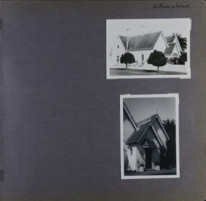
Album - Album page, Avoca Grove, 12, Circa 1972
This photograph is part of the Caulfield Historical Album 1972. This album was created in approximately 1972 as part of a project by the Caulfield Historical Society to assist in identifying buildings worthy of preservation. The album is related to a Survey the Caulfield Historical Society developed in collaboration with the National Trust of Australia (Victoria) and Caulfield City Council to identify historic buildings within the City of Caulfield that warranted the protection of a National Trust Classification. Principal photographer thought to be Trevor Hart, member of Caulfield Historical Society. Most photographs were taken between 1966-1972 with a small number of photographs being older and from unknown sources. All photographs are black and white except where stated, with 386 photographs over 198 pages.From Glen Eira Heritage Management Plan (1996) by Andrew Ward and Associates: The house at 12 Avoca Grove, part of "Merton", now demolished, is understood to have been built for and occupied by James Wilberforce Stephens from c.1865. It has aesthetic and historical significance. The building's aesthetic value is derived from the manner in which it demonstrates aspects of the Cottage Orne style, popular among Melboume's gentry during the mid Victorian period. Its historical value is derived from its association with J. W. Stephens, MLA, for East St Kilda and a prominent Caulfield resident.Page 20 of Photograph Album - two black and white exterior photographs of a house with both photographs on the right hand side of the page, the top in landscape mode and the bottom portrait. Hand written: 12 Avoca Grove [top right of page] / 20 [bottom right]trevor hart, avoca grove, church, caulfield north, merton, james wilberforce stephens, cottage orne style, j w stephens (mla) -
 Glen Eira Historical Society
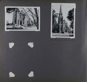
Album - Album page, St Aloysius Roman Catholic Church (Balaclava Road), Circa 1972
This photograph is part of the Caulfield Historical Album 1972. This album was created in approximately 1972 as part of a project by the Caulfield Historical Society to assist in identifying buildings worthy of preservation. The album is related to a Survey the Caulfield Historical Society developed in collaboration with the National Trust of Australia (Victoria) and Caulfield City Council to identify historic buildings within the City of Caulfield that warranted the protection of a National Trust Classification. Principal photographer thought to be Trevor Hart, member of Caulfield Historical Society. Most photographs were taken between 1966-1972 with a small number of photographs being older and from unknown sources. All photographs are black and white except where stated, with 386 photographs over 198 pages.From: Glen Eira Heritage Management Plan (1996) by Andrew Ward and Associates St Aloysius is architecturally important as an exceptionally imposing red brick church in the Early English Gothic Style from the inter-war period. Its significance, however, is compromised by the recent removal of its Pyrmont stone spire. It is locally important as a focus of Catholic worship in Caulfield.Page 23 of Photograph Album with two black and white photographs of front views of a church. There is also a photo missing on the bottom left. Hand written: 233 [above top right photo] / St Aloysius R C Church [under top right photo] / 23[bottom left]trevor hart, caulfield north, balaclava road, st aloysius, early english gothic, inter-war period, catholic church, towers, red brick -
 Glen Eira Historical Society
Album - Album page, St Stephen's Presbyterian Church, Balaclava Road, Circa 1972
This photograph is part of the Caulfield Historical Album 1972. This album was created in approximately 1972 as part of a project by the Caulfield Historical Society to assist in identifying buildings worthy of preservation. The album is related to a Survey the Caulfield Historical Society developed in collaboration with the National Trust of Australia (Victoria) and Caulfield City Council to identify historic buildings within the City of Caulfield that warranted the protection of a National Trust Classification. Principal photographer thought to be Trevor Hart, member of Caulfield Historical Society. Most photographs were taken between 1966-1972 with a small number of photographs being older and from unknown sources. All photographs are black and white except where stated, with 386 photographs over 198 pages. From: Glen Eira Heritage Management Plan (1996) by Andrew Ward and Associates: In 1905, the land was vacant in Balaclava Road, north side, from Kooyong Road east to the right of way, except for one house. A block of this land was acquired by the Presbyterian community and a timber church erected there in 1910. In time, a larger church was required. After several years of fund raising led by George Kinross, a new red brick St Stephen's church was built in 1926 to the design of architects Haddon and Henderson. George Currie was the builder and the cost of construction was £5,100.Glen Eira Heritage Management Plan 1996 by Andrew Ward St Stephens has architectural importance as a noteworthy example of a Gothic Transitional design in the Arts and Crafts eclectic manner (see Stylistic Typology in National Trust's Historic Church's Study}. The facade treatment successfully combines Christian symbols with Gothic forms in the Arts and Crafts mode (comparable with Haddon's Presbyterian Church, Malvern (1906) and Haddon and Henderson's Oakleigh Church (1928). It is locally important as an example of Robert Haddon's work in Caulfield, where he also lived (4 Glenferrie St q.v.).Page 24 of Photograph Album with four black and white photographs of St Stephen's Presbyterian Church, with Balaclava Road written on the top right hand side. Three photos are of the exterior and one is a wide view of the inside towards the altar.Hand written: St Stephen's Presbyterian Church Balaclava Road [top right of page] / 24 [bottom right]trevor hart, caulfield north, balaclava road, george kinross, haddon and henderson, george currie, st stephen's, 1900's, 1920's, gothic transitional, christian symbols, arts and crafts, robert haddon, stylistic typology, gothic, presbyterian church, architects, red bricks, entrances -
 Glen Eira Historical Society
Album - Album page, St Stephen's Presbyterian Church, Balaclava Road, Circa 1972
This photograph is part of the Caulfield Historical Album 1972. This album was created in approximately 1972 as part of a project by the Caulfield Historical Society to assist in identifying buildings worthy of preservation. The album is related to a Survey the Caulfield Historical Society developed in collaboration with the National Trust of Australia (Victoria) and Caulfield City Council to identify historic buildings within the City of Caulfield that warranted the protection of a National Trust Classification. Principal photographer thought to be Trevor Hart, member of Caulfield Historical Society. Most photographs were taken between 1966-1972 with a small number of photographs being older and from unknown sources. All photographs are black and white except where stated, with 386 photographs over 198 pages. From: Glen Eira Heritage Management Plan (1996) by Andrew Ward and Associates In 1905, the land was vacant in Balaclava Road, north side, from Kooyong Road east to the right of way, except for one house. A block of this land was acquired by the Presbyterian community and a timber church erected there in 1910. In time, a larger church was required. After several years of fund raising led by George Kinross, a new red brick St Stephen's church was built in 1926 to the design of architects Haddon and Henderson. George Currie was the builder and the cost of construction was £5,100.From: Glen Eira Heritage Management Plan (1996) by Andrew Ward and Associates: St Stephens has architectural importance as a noteworthy example of a Gothic Transitional design in the Arts and Crafts eclectic manner (see Stylistic Typology in National Trust's Historic Church's Study}. The facade treatment successfully combines Christian symbols with Gothic forms in the Arts and Crafts mode (comparable with Haddon's Presbyterian Church, Malvern (1906) and Haddon and Henderson's Oakleigh Church (1928). It is locally important as an example of Robert Haddon's work in Caulfield, where he also lived (4 Glenferrie St q.v.).Page 25 of Photograph Album - four black and white photographs of St Stephen's Presbyterian Church, with two photographs in landscape mode across the top showing information about who designed the building in one and showing the church name and year founded in the other; and two in portrait mode in the bottom section showing 2 different heavy wooden doors.Hand written: 25 [bottom left]trevor hart, caulfield north, balaclava road, george kinross, haddon and henderson, george currie, st stephen's, 1900's, 1920's, gothic transitional, christian symbols, arts and crafts, robert haddon, stylistic typology, gothic, presbyterian church, architects, red brick, doors, memorials -
 Glen Eira Historical Society
Album - Album page, St Stephen's Presbyterian Church, Balaclava Road, Circa 1972
This photograph is part of the Caulfield Historical Album 1972. This album was created in approximately 1972 as part of a project by the Caulfield Historical Society to assist in identifying buildings worthy of preservation. The album is related to a Survey the Caulfield Historical Society developed in collaboration with the National Trust of Australia (Victoria) and Caulfield City Council to identify historic buildings within the City of Caulfield that warranted the protection of a National Trust Classification. Principal photographer thought to be Trevor Hart, member of Caulfield Historical Society. Most photographs were taken between 1966-1972 with a small number of photographs being older and from unknown sources. All photographs are black and white except where stated, with 386 photographs over 198 pages. From: Glen Eira Heritage Management Plan (1996) by Andrew Ward and Associates In 1905, the land was vacant in Balaclava Road, north side, from Kooyong Road east to the right of way, except for one house. A block of this land was acquired by the Presbyterian community and a timber church erected there in 1910. In time, a larger church was required. After several years of fund raising led by George Kinross, a new red brick St Stephen's church was built in 1926 to the design of architects Haddon and Henderson. George Currie was the builder and the cost of construction was £5,100.From: Glen Eira Heritage Management Plan (1996) by Andrew Ward and Associates: St Stephens has architectural importance as a noteworthy example of a Gothic Transitional design in the Arts and Crafts eclectic manner (see Stylistic Typology in National Trust's Historic Church's Study}. The facade treatment successfully combines Christian symbols with Gothic forms in the Arts and Crafts mode (comparable with Haddon's Presbyterian Church, Malvern (1906) and Haddon and Henderson's Oakleigh Church (1928). It is locally important as an example of Robert Haddon's work in Caulfield, where he also lived (4 Glenferrie St q.v.).Page 26 of Photograph Album including three black and white photographs of St Stephen's Presbyterian Church, with two photographs in portrait mode across the top showing 2 different stained glass windows from the inside; and one in landscape mode in the bottom section which appears to be a photograph of a framed photograph or drawing of the church.Hand written: St Stephen's Presbyterian Church Balaclava Road [top right] / 26 [bottom right]trevor hart, caulfield north, balaclava road, george kinross, haddon and henderson, george currie, st stephen's, 1900's, 1920's, gothic transitional, christian symbols, arts and crafts, robert haddon, stylistic typology, gothic, drawings, presbyterian church, architects, lead lights, stained glass windows -
 Glen Eira Historical Society
Album - Album page, St Stephen's Presbyterian Church, Balaclava Road, Circa 1972
This photograph is part of the Caulfield Historical Album 1972. This album was created in approximately 1972 as part of a project by the Caulfield Historical Society to assist in identifying buildings worthy of preservation. The album is related to a Survey the Caulfield Historical Society developed in collaboration with the National Trust of Australia (Victoria) and Caulfield City Council to identify historic buildings within the City of Caulfield that warranted the protection of a National Trust Classification. Principal photographer thought to be Trevor Hart, member of Caulfield Historical Society. Most photographs were taken between 1966-1972 with a small number of photographs being older and from unknown sources. All photographs are black and white except where stated, with 386 photographs over 198 pages. From: Glen Eira Heritage Management Plan (1996) by Andrew Ward and Associates In 1905, the land was vacant in Balaclava Road, north side, from Kooyong Road east to the right of way, except for one house. A block of this land was acquired by the Presbyterian community and a timber church erected there in 1910. In time, a larger church was required. After several years of fund raising led by George Kinross, a new red brick St Stephen's church was built in 1926 to the design of architects Haddon and Henderson. George Currie was the builder and the cost of construction was £5,100.From: Glen Eira Heritage Management Plan (1996) by Andrew Ward and Associates: St Stephens has architectural importance as a noteworthy example of a Gothic Transitional design in the Arts and Crafts eclectic manner (see Stylistic Typology in National Trust's Historic Church's Study}. The facade treatment successfully combines Christian symbols with Gothic forms in the Arts and Crafts mode (comparable with Haddon's Presbyterian Church, Malvern (1906) and Haddon and Henderson's Oakleigh Church (1928). It is locally important as an example of Robert Haddon's work in Caulfield, where he also lived (4 Glenferrie St q.v.).Page 27 of Photograph Album with one photograph of a drawing or perhaps a postcard of St Stephen's Presbyterian Church. It has a large block of formal writing in the bottom right corner which looks official.Hand written: 27 [bottom right]trevor hart, caulfield north, balaclava road, george kinross, haddon and henderson, george currie, st stephen's, 1900's, 1920's, gothic transitional, christian symbols, arts and crafts, robert haddon, stylistic typology, gothic, presbyterian church, architects, drawings -
 Glen Eira Historical Society
Album - Album page, Kynaston now Kahlyn, Bambra Road, Circa 1972
This photograph is part of the Caulfield Historical Album 1972. This album was created in approximately 1972 as part of a project by the Caulfield Historical Society to assist in identifying buildings worthy of preservation. The album is related to a Survey the Caulfield Historical Society developed in collaboration with the National Trust of Australia (Victoria) and Caulfield City Council to identify historic buildings within the City of Caulfield that warranted the protection of a National Trust Classification. Principal photographer thought to be Trevor Hart, member of Caulfield Historical Society. Most photographs were taken between 1966-1972 with a small number of photographs being older and from unknown sources. All photographs are black and white except where stated, with 386 photographs over 198 pages.https://vhd.heritagecouncil.vic.gov.au/places/35575 From: Glen Eira Heritage Management Plan (1996) by Andrew Ward and Associates Significance: "Kynaston" is locally important as a large late Victorian villa residence, demonstrating something of the lifestyle to which a senior government bureaucrat could aspire during the late nineteenth century boom period. The design of the verandah, though defaced, is unusual in Caulfield and, therefore, important. A substantial late Victorian stuccoed Bool11 style villa residence with tower surmounting the entrance porch, fluted columns to the ground level verandah and parapeted balcony over, now built in with a sympathetic addition at the north-west corner. The principal rooms and staircase are intact and representative of the period.Page 34 of Photograph Album with two portrait photographs of exterior of Kynaston - 2 views highlighting the front of the mansionHand written: "Kynaston" now "Kahlyn" Bambra Road [top right] / 34 [bottom right] trevor hart, caulfield north, bambra road, 1850's, mansion, villa residence, cast iron verandah, victorian, decorative brackets, slate roof, curved windows, 1880's, kynaston, kynaston l murray, kahlyn private hospital, kahlyn, return verandah, enclosed verandah, cast iron work, double storey mansions, towers, balconies -
 Glen Eira Historical Society
Album - Album page, Paynswicke, Gladstone Pde & Hartington St, Circa 1972
This photograph is part of the Caulfield Historical Album 1972. This album was created in approximately 1972 as part of a project by the Caulfield Historical Society to assist in identifying buildings worthy of preservation. The album is related to a Survey the Caulfield Historical Society developed in collaboration with the National Trust of Australia (Victoria) and Caulfield City Council to identify historic buildings within the City of Caulfield that warranted the protection of a National Trust Classification. Principal photographer thought to be Trevor Hart, member of Caulfield Historical Society. Most photographs were taken between 1966-1972 with a small number of photographs being older and from unknown sources. All photographs are black and white except where stated, with 386 photographs over 198 pages. House is commonly spelt as "Payneswicke".From: Glen Eira Heritage Management Plan (1996) by Andrew Ward and Associates "Payneswicke" is locally significant as a prominent and substantially intact villa of its period, distinguished by its cast cement enrichment, unpainted stuccoed surfaces and commanding aspect to the south-west. Its role for a period as home for local builder, Patrick Millane (compare no. 11 Gladstone Parade) is of interest. In 1889, a nine roomed brick house was in the course of erection on the site. The house was completed in 1890 and Millane took up residence. Millane continued as owner/ occupant in 1894. However, in 1899, although Millane still occupied the house, ownership had been taken over by the Land Mortgage Bank. By 1910, Andrew Brown was occupant. Occupancy passed to Edward Brown by 1920 and to Miss A.N. Brown by 1930. Miss Brown continued to live there in 1941.Page 50 of Photograph Album with three exterior photographs (2 landscape and 1 portrait) of Paynswicke, a double storey house.Hand written: No 13 [top right] / "Paynswicke" N.E. cnr Gladstone Pd & Hartington St [top right] / 8 Oct 1966 [under top left photo] / 50 [bottom right] trevor hart, 1880's, 1890's, payneswicke, patrick millane, gladstone parade, unpainted stuccoed surfaces, cast cement enrichment, hartington street, villa residence, italianate, elsternwick, victorian, mansion, cast iron verandahs, return verandahs, curved windows, full length windows, land mortgage bank, andrew brown, edward brown, a n brown, paynswicke -
 Glen Eira Historical Society
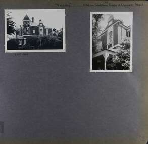
Album - Album page, Eversley, Gladstone Parade & Clarence Street, Circa 1972
This photograph is part of the Caulfield Historical Album 1972. This album was created in approximately 1972 as part of a project by the Caulfield Historical Society to assist in identifying buildings worthy of preservation. The album is related to a Survey the Caulfield Historical Society developed in collaboration with the National Trust of Australia (Victoria) and Caulfield City Council to identify historic buildings within the City of Caulfield that warranted the protection of a National Trust Classification. Principal photographer thought to be Trevor Hart, member of Caulfield Historical Society. Most photographs were taken between 1966-1972 with a small number of photographs being older and from unknown sources. All photographs are black and white except where stated, with 386 photographs over 198 pages. Property now known as Eversley, formerly Nulmore then Brampton. From Caulfield Heritage Management Plan 1996 by Andrew Ward In 1888, C. Hume owned lots 61, 62 and 63 in the Kooyong Park Estate, on the northwest corner of Gladstone Parade and Clarence Street. In 1889 Thomas B. Jackson, architect, of Shoobra Road, purchased the land and in the same year built a ten roomed brick house on lot 63 and part lot 62. Jackson leased the property to William Dalrymple in 1890. By 1894, the property was owned by P. Langwill and leased to James Ainslie, an accountant. By 1899, Frederick Henriques had moved into the house, which was known as ''Nulmore". In 1910, the house was vacant. In 1920, it was leased to Augustine Barbeta who continued to live there in 1930. By 1934, the house was renamed ''Brampton". ''Nulmore" is locally important as an unusually imposing Elizabethan influenced villa in Caulfield, comparing with nos. 34 and 25 Gladstone Parade. Its link with local architect Thomas B Jackson is of interest. Page 52 of Photograph Album with two exterior photographs (one landscape and one portrait) of Eversley , a double storey mansion.Hand written: (36 )[top right] / "Eversley" N.W. cnr Gladstone Parade & Clarence Street [top right] / 8 Oct 1966 [under top left photo] / 52 [bottom right] trevor hart, 1880's, 1890's, gladstone parade, eversley, victorian, clarence street, architectural features, nulmore, brampton, kooyong park estate, architect, shoobra road, hume, elsternwick, double storey mansions, thomas b jackson, william dalrymple, p langwill, james ainslie, frederick henriques, augustine barbeta, elizabethan style, house names -
 Glen Eira Historical Society
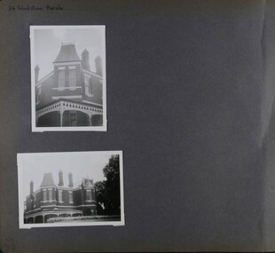
Album - Album page, Gladstone Parade, 34, Circa 1972
This photograph is part of the Caulfield Historical Album 1972. This album was created in approximately 1972 as part of a project by the Caulfield Historical Society to assist in identifying buildings worthy of preservation. The album is related to a Survey the Caulfield Historical Society developed in collaboration with the National Trust of Australia (Victoria) and Caulfield City Council to identify historic buildings within the City of Caulfield that warranted the protection of a National Trust Classification. Principal photographer thought to be Trevor Hart, member of Caulfield Historical Society. Most photographs were taken between 1966-1972 with a small number of photographs being older and from unknown sources. All photographs are black and white except where stated, with 386 photographs over 198 pages. From Caulfield Heritage Management Plan 1996 by Andrew Ward In 1889, Thomas B Jackson, an architect in Shoobra Road, owned lots 61-63 at the north west intersection with Clarence Street. He built the two red brick houses, each of 10 rooms, known as "Kenly" and "Nulmore" (later "Brampton") in that year. By 1894, P. Langwill had purchased the property, leasing it to Fred Henriques, an accountant. Alfred Pearson a government chemist, was occupying tenant by 1899. The property was known as ''Kenly''. In 1910, the house was vacant, however, in 1920, James Edmends was living there and continued to do so in 1930. By 1941, Edmends had moved to No. 32, and Alfred Williamson was in residence. "Kenly'' is important as an unusually imposing Elizabethan influenced villa in Caulfield, comparing with nos. 25 and 36 Gladstone Parade. Its importance is enhanced by its substantially intact state whilst its link with local architect Thomas B Jackson is of interest.Page 53 of Photograph Album with two exterior photographs (one portrait and one landscape) of a double storey brick mansion.Hand written: 34 Gladstone Parade [top left] / 53 [bottom left] trevor hart, 1880's, 1890's, gladstone parade, eversley, victorian, double storey, clarence street, architectural features, nulmore, brampton, kooyong park estate, architect, shoobra road, elsternwick, kenly, elizabethan influence, thomas b jackson, p langwill, fred henriques, alfred pearson, james edmends, alfred wiliamson, house names -
 Glen Eira Historical Society
Album - Album page, Glen Eira Road, Circa 1972
This photograph is part of the Caulfield Historical Album 1972. This album was created in approximately 1972 as part of a project by the Caulfield Historical Society to assist in identifying buildings worthy of preservation. The album is related to a Survey the Caulfield Historical Society developed in collaboration with the National Trust of Australia (Victoria) and Caulfield City Council to identify historic buildings within the City of Caulfield that warranted the protection of a National Trust Classification. Principal photographer thought to be Trevor Hart, member of Caulfield Historical Society. Most photographs were taken between 1966-1972 with a small number of photographs being older and from unknown sources. All photographs are black and white except where stated, with 386 photographs over 198 pages. From Glen Eira Heritage Management Plan 1996 by Andrew Ward: Since 1990, valuable historic houses to have been demolished include "Noris", later "Quethiock", and "Koala" (1875) at 34 Balaclava Road, "Urandaline", later Samford private hospital at 510 Glen Eira Road, and No. 9 Lempriere Avenue. When the Caulfield Tramway Company opened its single line horse tramway along Glen Eira Road to Caulfield station in 1889, the eastern end of this road passed through open paddocks and alongside "Urandaline", a charming late Victorian villa residence with comer pinnacle roof, demolished in 1995.Page 59 of Photograph Album with five photographs, one portrait of the exterior of a house on Glen Eira Road, the other four are photos of sections of advertising materials for Urandaline Estate.Hand written: 508 Glen Eira Road [under top left photo] / 58 [bottom left] trevor hart, glen eira road, caulfield north, urandaline, urandaline estate, horse tram, land subdivision, real estate advertising, verandahs -
 Glen Eira Historical Society
Album - Album page, Glenferrie Street, 4, Circa 1972
This photograph is part of the Caulfield Historical Album 1972. This album was created in approximately 1972 as part of a project by the Caulfield Historical Society to assist in identifying buildings worthy of preservation. The album is related to a Survey the Caulfield Historical Society developed in collaboration with the National Trust of Australia (Victoria) and Caulfield City Council to identify historic buildings within the City of Caulfield that warranted the protection of a National Trust Classification. Principal photographer thought to be Trevor Hart, member of Caulfield Historical Society. Most photographs were taken between 1966-1972 with a small number of photographs being older and from unknown sources. All photographs are black and white except where stated, with 386 photographs over 198 pages. From Glen Eira Heritage Management Plan 1996 by Andrew Ward: In 1905, most of portion 27 was vacant land, however Glenferrie Street had been formed and the land subsequently subdivided. In 1906, Robert Joseph Haddon, architect and painter, designed and built for his private residence, a brick house on the west side. Haddon named the house "Anselm". Also built on the property were a garage and fibro cement studio. "Anselm" is architecturally important at the State level as a substantially intact, highly personalised and boldly expressed house expressive the Arts and Crafts movement and incorporating Art Nouveaux enrichment in a variety of forms, the use of ornamental terra cotta tiles to the comer tower being of special note. Its importance at the State level is strengthened by its place as the home of the noted architect and Melbourne's most influential exponent (Freeland, J.M., Architecture in Australia, p. 213) of the Art Nouveaux movement.https://vhd.heritagecouncil.vic.gov.au/places/4442 Victorian Heritage Register: What is significant? Anselm was designed by noted English born architect Robert Joseph Haddon(1866-1929) as his own house and constructed in 1906. A single storey Arts and Crafts influenced red brick house with attic, Anselm has a pyramidal slate roof with prominent chimney stacks. There is a octagonal corner tower with saucer shaped domed roof surmounted by a weather vane, and the tower has decorative terracotta panels immediately below the eaves line. The front door opens immediately into a large living or common room, screened from view by a timber and bottle glass screen. The large room was designed to function as a drawing and dining room. The house is rich with hand crafted details including door and window furniture, wrought iron gutter brackets, fireplaces (one with built in wood box), and fire tools. The interior decoration includes hand painted frieze of Port Phillip in the study, and a hand painted frieze of turbulent sea with sailing boats in the tiled bathroom. There is a small hand painted tile at the base of the tower which states ?This building was erected AD1906 from designs by Robt J Haddon FRIBA,Lond FRIVA Melb Architect?. He also designed an attic addition which was constructed in 1927. Anselm is substantially intact although the double casement window immediately to the south of the front door was originally circular....Page 60 of Photograph Album with three exterior photographs (one portrait and two landscape) of Anselm.Hand written: 4 Glenferrie Street [top right] / ANSELM 4 Glenferrie St [under top photo] / 60 [bottom right] trevor hart, anselm, art nouveaux, arts and crafts, tower, bay window, glenferrie street, robert joseph haddon, 1900's, terra cotta tiles, double storey, caulfield north, corner tower, gates, cast iron work -
 Glen Eira Historical Society
Album - Album page, Glenferrie Street, 4, Circa 1972
This photograph is part of the Caulfield Historical Album 1972. This album was created in approximately 1972 as part of a project by the Caulfield Historical Society to assist in identifying buildings worthy of preservation. The album is related to a Survey the Caulfield Historical Society developed in collaboration with the National Trust of Australia (Victoria) and Caulfield City Council to identify historic buildings within the City of Caulfield that warranted the protection of a National Trust Classification. Principal photographer thought to be Trevor Hart, member of Caulfield Historical Society. Most photographs were taken between 1966-1972 with a small number of photographs being older and from unknown sources. All photographs are black and white except where stated, with 386 photographs over 198 pages. From Glen Eira Heritage Management Plan 1996 by Andrew Ward: In 1905, most of portion 27 was vacant land, however Glenferrie Street had been formed and the land subsequently subdivided. In 1906, Robert Joseph Haddon, architect and painter, designed and built for his private residence, a brick house on the west side. Haddon named the house "Anselm". Also built on the property were a garage and fibro cement studio. "Anselm" is architecturally important at the State level as a substantially intact, highly personalised and boldly expressed house expressive the Arts and Crafts movement and incorporating Art Nouveaux enrichment in a variety of forms, the use of ornamental terra cotta tiles to the comer tower being of special note. Its importance at the State level is strengthened by its place as the home of the noted architect and Melboume's most influential exponent (Freeland, J.M., Architecture in Australia, p. 213) of the Art Nouveaux movement. Victorian Heritage Register https://vhd.heritagecouncil.vic.gov.au/places/4442 What is significant? Anselm was designed by noted English born architect Robert Joseph Haddon(1866-1929) as his own house and constructed in 1906. A single storey Arts and Crafts influenced red brick house with attic, Anselm has a pyramidal slate roof with prominent chimney stacks. There is a octagonal corner tower with saucer shaped domed roof surmounted by a weather vane, and the tower has decorative terracotta panels immediately below the eaves line. The front door opens immediately into a large living or common room, screened from view by a timber and bottle glass screen. The large room was designed to function as a drawing and dining room. The house is rich with hand crafted details including door and window furniture, wrought iron gutter brackets, fireplaces (one with built in wood box), and fire tools. The interior decoration includes hand painted frieze of Port Phillip in the study, and a hand painted frieze of turbulent sea with sailing boats in the tiled bathroom. There is a small hand painted tile at the base of the tower which states ?This building was erected AD1906 from designs by Robt J Haddon FRIBA,Lond FRIVA Melb Architect?. He also designed an attic addition which was constructed in 1927. Anselm is substantially intact although the double casement window immediately to the south of the front door was originally circular....Page 61 of Photograph Album with one exterior photograph (portrait) of Anselm.Hand written: 61 [bottom left] trevor hart, anselm, art nouveaux, arts and crafts, tower, bay window, glenferrie street, robert joseph haddon, 1900's, terra cotta tiles, double storey, caulfield north, corner tower, brick house, attics -
 Glen Eira Historical Society
Album - Album page, Glen Huntly Road, Circa 1972
This photograph is part of the Caulfield Historical Album 1972. This album was created in approximately 1972 as part of a project by the Caulfield Historical Society to assist in identifying buildings worthy of preservation. The album is related to a Survey the Caulfield Historical Society developed in collaboration with the National Trust of Australia (Victoria) and Caulfield City Council to identify historic buildings within the City of Caulfield that warranted the protection of a National Trust Classification. Principal photographer thought to be Trevor Hart, member of Caulfield Historical Society. Most photographs were taken between 1966-1972 with a small number of photographs being older and from unknown sources. All photographs are black and white except where stated, with 386 photographs over 198 pages. From: Glen Eira Heritage Management Plan (1996) by Andrew Ward and Associates Moore's Buildings", were built in 1891 and comprising 5 shops. In 1888, Hugh Moore, a gentleman, subdivided his land in Glen Huntly Road, north side between Selwyn Street and St Georges Road into 27 lots, with a right of way separating them from his property "Glenmoore". The subdivision was known as the "Glenmoore Estate". Purchases of land included local builders Corkill, French and Pugh. Moore retained five lots and W.W. Jamieson bought lots 11 to 14. "Moore' s Buildings are locally important for their association with the early Elsternwick land owner, Hugh Moore, whose home, "Glenmoore", at 1 St.Georges Road (qv) survives. They recall Elsternwick's role in the Land Boom and survive as a most prominent row in the Glen Huntly Road shops, enhanced by the survival of the unpainted stuccoed surfaces to nos. 307-311. 287-289 Glen Huntly Road: contributory to HO72, Elsternwick Estate and Environs, City of Glen Eira.Page 63 of Photograph Album with one landscape photograph of retail shops (Moore's Buildings).Hand written: 287-289 Glen Huntly Road [under photo] / 63 [bottom left] trevor hart, shop, grocer, stuccoed, terrace, victorian terrace, protruding parapet, ornate render, hugh moore, 1890's, moore's buildings, glenmoore, glenmoore estate, shopping centres, milk bars, cars, victorian style, glen huntly road, glenhuntly road, elsternwick -
 Glen Eira Historical Society
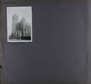
Album - Album page, Glen Huntly Road, Circa 1972
This photograph is part of the Caulfield Historical Album 1972. This album was created in approximately 1972 as part of a project by the Caulfield Historical Society to assist in identifying buildings worthy of preservation. The album is related to a Survey the Caulfield Historical Society developed in collaboration with the National Trust of Australia (Victoria) and Caulfield City Council to identify historic buildings within the City of Caulfield that warranted the protection of a National Trust Classification. Principal photographer thought to be Trevor Hart, member of Caulfield Historical Society. Most photographs were taken between 1966-1972 with a small number of photographs being older and from unknown sources. All photographs are black and white except where stated, with 386 photographs over 198 pages. From: Glen Eira Heritage Management Plan (1996) by Andrew Ward and Associates This Area is marked by the imposing brick and freestone gothic Revival church of the Holy Cross, built in 1937 to the design of O.H. Jorgensen. Church of the Holy Cross and Presbytery are contributory buildings to HO66.Page 65 of Photograph Album with one exterior photograph (landscape) of a brick church with a three storey tower.Hand written: Glenhuntly Rd [top left] / HOLY CROSS RC CHURCH / Dec 1972 [written underneath the photo] / 65 [bottom left] trevor hart, 1930's, gothic revival, brick, bell tower, spire, facade, catholic church, o h jorgensen, holy cross catholic church, caulfield, glenhuntly road, caulfield south, presbytery -
 Glen Eira Historical Society
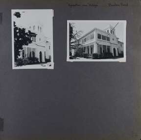
Album - Album page, Booran Road, 30, Circa 1972
This photograph is part of the Caulfield Historical Album 1972. This album was created in approximately 1972 as part of a project by the Caulfield Historical Society to assist in identifying buildings worthy of preservation. The album is related to a Survey the Caulfield Historical Society developed in collaboration with the National Trust of Australia (Victoria) and Caulfield City Council to identify historic buildings within the City of Caulfield that warranted the protection of a National Trust Classification. Principal photographer thought to be Trevor Hart, member of Caulfield Historical Society. Most photographs were taken between 1966-1972 with a small number of photographs being older and from unknown sources. All photographs are black and white except where stated, with 386 photographs over 198 pages. From Glen Eira Heritage Management Plan 1996 by Andrew Ward: In 1888, John Leek, a trainer, owned Lot 15, measuring one and three quarter acres, in Booran Road, north side between Glen Eira and Neerim Roads. The land backed onto the Caulfield Racecourse Reserve. NAV was £45. In 1890 Leek built for his residence, a ten roomed brick house on the site. NAV was £200. Leek was the owner/trainer of "Ingliston" who won the Caulfield Cup in 1900. Upon the horse's death in 1901, Leek is understood to have defied tradition by spending £20 on boots for the "ragged urchins in Bourke Street" instead of "shouting" at the bar. By 1899, the property was owned and occupied by Alfred Merrill, a dentist and was known as "Andover". NA V had decreased to £ll0. By 1910, Leslie Macdonald, a gentleman had purchased the property and renamed it "Moidart". In 1910-11 Macdonald sold it to John Robertson. The property had extensive wood stables on its north-east boundary and several other outbuildings. The house continued to be described as "Brick, ten rooms" as it was in 1926 when it was owned and occupied by John Arthur, a managing director. The land measured la.2r.31p. and had a NAV of £235. Nine people lived there. In 1926, Arthur also owned the adjoining Lot 16. Other racehorses of note, known to have been stabled here include Sobar, Havelock, Proud, Future and Lord.Victorian Heritage Register https://vhd.heritagecouncil.vic.gov.au/places/13532 What is significant? Lord Lodge is a thoroughbred racehorse training complex adjacent to Caulfield Racecourse, established in 1890. The area immediately around the racecourse has been associated with horse racing activities and businesses servicing the industry since the development of the racecourse in late the 19th century. Lord Lodge was named by the present occupants after the champion racehorse Lord who was stabled there in the 1950s. In the early 20th century the property was known as 'Andover' and subsequently 'Moidart'. The site consists of a single storey brick Italianate villa, jockeys' quarters, stables and open day yards with direct access to Caulfield racecourse from the rear of the property. The villa of 10 rooms on bluestone foundations was constructed in 1890 by John Leek, a horse trainer who purchased the newly subdivided land in 1888. The house has many Victorian Italianate or Boom Style features although it is more modest than many villas of its style. It has an asymmetrical facade with a faceted bay window and a prominent central tower with low pitch pyramidal roof that provides a clear view of the racecourse. Other characteristic features include stilted segmented arches, bracketed eaves, stucco wall finish and cast cement ornamentation. A room has been added on the north-facing verandah in sympathetic style and finish. Internally the rooms are substantially intact with original marble fireplaces and intricate ceiling roses and cornices. An entrance toward the rear of the southern side of the house is said to be where the stable hands, jockeys and other staff lined up for their meals. In the southeast corner of the property, backing directly on to Caulfield racecourse, is a substantial late Victorian timber stable, probably constructed in the 1890s but first appearing on the property title in 1910. The stable has 12 stalls, a loft and brick pavement and jerkin head roof form with varnished pine-lined ceiling carried on a chamfered timber frame. It has an original roof lantern. The doors of the stalls are not the original sliding doors but swing doors obtained from a barn at Epsom Racecourse in Mordialloc prior to demolition. Outside the gambrel roof has fretted barges but the building is otherwise utilitarian. Timber throughout the stalls has been worn by chewing and rubbing of horses over the century of its use. In the southern half of the property are open day yards where the racehorses are kept during the day. The red brick, single storey jockeys' quarters to the rear of the villa were probably built around 1950. A small brick, possibly late Victorian structure on the eastern boundary thought to have originally been a gardening shed, has been converted to a stable of two stalls. Modern concrete brick stables fill the northeast portion of the property. At the front of the property two Moreton Bay Figs (Ficus macrophylla), probably planted in the late 19th century, provide shade for horses in the day yards. In the 1890s John Leek sold the property, relocating his training facility to one of the newly established racecourses at Mentone or Mordialloc (Epsom). By 1899, the property was owned and occupied by Alfred Merrill, a dentist, who named the property 'Andover'. In 1910 it was purchased by Leslie McDonald, a gentleman, and renamed 'Moidart'; sold in 1910-1911 to John Robertson; and again in 1926 to John Arthur, a racehorse owner. The Victorian Amateur Turf Club purchased the property in the late 1930s and since this time has been leased to racehorse trainers. It is unclear whether the property operated as a training facility between 1899 - 1926. Several notable trainers and jockeys are associated with Lord Lodge. The best known is Arthur 'Scobie' Breasley, Australia's most successful jockey who was apprenticed to trainer Pat Quinlan at Lord Lodge (then 'Moidart') from 1928 - 1935. Breasley rode winners of the Caulfield Cup in four successive years 1942-45 and again in 1952. John Leek, the original owner of Lord Lodge trained Ingliston, the 1900 Caulfield Cup winner. Along with 'Lord' a number of well known racehorses including Sobar, Havelock, Proud and Future were trained at Lord Lodge .....Page 40 of Photograph Album with three landscape photographs of the exterior of this house.Handwritten: 30 Booran Road [top right hand corner] / 40 [bottom right]trevor hart, jenny o'donnell, booran road, mansion, caulfield east, ingliston, sobar, havelock, proud, future, lord, andover, moidart, lord lodge, grace darling, caulfield racecourse reserve, victorian amateur turf club, historic buildings register, national estate register, caulfield cup, horses, stables, horse racing, racehorses, outbuildings, racehorse trainers, depression, 1890s, brick houses, mansions, towers, verandahs, stained glass, italianate style, victorian style, architectural features, architectural styles, john leek, leslie macdonald, john arthur, john robertson, alfred merrill, jenny odonnell -
 Glen Eira Historical Society
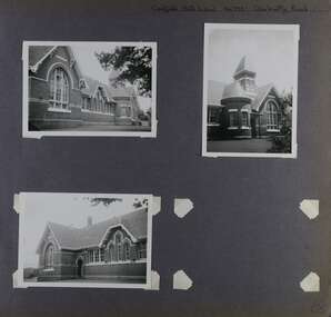
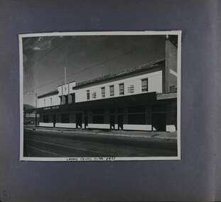
Album - Album page, Caulfield State School, No 773, Glen Huntly Road, Circa 1972
This photograph is part of the Caulfield Historical Album 1972. This album was created in approximately 1972 as part of a project by the Caulfield Historical Society to assist in identifying buildings worthy of preservation. The album is related to a Survey the Caulfield Historical Society developed in collaboration with the National Trust of Australia (Victoria) and Caulfield City Council to identify historic buildings within the City of Caulfield that warranted the protection of a National Trust Classification. Principal photographer thought to be Trevor Hart, member of Caulfield Historical Society. Most photographs were taken between 1966-1972 with a small number of photographs being older and from unknown sources. All photographs are black and white except where stated, with 386 photographs over 198 pages.From: Glen Eira Heritage Management Plan (1996) by Andrew Ward and Associates Caulfield State School No. 773 is important at the State level as the first of similar designs for small schools prepared by the Education Department under H.R. Bastow at Little Bendigo (1878), Glen Waverley (1880), Ascot (1882), Sandringham (1885) and Carlsrich (1892)·. It is a representative example of the Department's Gothic Revival designs, distinguished, however, by the semicircular treatment of the master's office, which compares with Portland (1879), Queensberry St Carlton (1880) and Footscray (1881). It has local significance as the earliest surviving Government School in Caulfield and as a centre for education from 1877, comparing with St. Mary's Jubilee School (qv) of 1887. The Caulfield State School of 1877, the horse tramway of 1889 and subsequently the electric trams were all events confirming the importance of Glenhuntly Road and the fledgling community of "Camden Town" wherein the City's commercial centre has its origins.Page 68 of Photograph Album with three exterior photographs (two portrait and one landscape) of one side of Caulfield State School with a fourth photo missing from the page.Hand written: Caulfield State School No. 773 Glenhuntly Road [top right] / 68 [bottom right] trevor hart, glen huntly road, caulfield state school, caulfield primary school, gothic revival, schools, caulfield south, arched window, tower, 1870's, camden town, red brick, curved windows, terracotta tiles, master's office, education, primary school, glenhuntly road, h r bastow -
 Glen Eira Historical Society
Album - Album page, London Tavern, Hawthorn Road, Circa 1972
This photograph is part of the Caulfield Historical Album 1972. This album was created in approximately 1972 as part of a project by the Caulfield Historical Society to assist in identifying buildings worthy of preservation. The album is related to a Survey the Caulfield Historical Society developed in collaboration with the National Trust of Australia (Victoria) and Caulfield City Council to identify historic buildings within the City of Caulfield that warranted the protection of a National Trust Classification. Principal photographer thought to be Trevor Hart, member of Caulfield Historical Society. Most photographs were taken between 1966-1972 with a small number of photographs being older and from unknown sources. All photographs are black and white except where stated, with 386 photographs over 198 pages. Glen Eira Heritage Management Plan 1996 by Andrew Ward The 1857 rate book indicates that the major portion of the District was under pasture, although a considerable portion was cultivated. There were 159 houses, huts and tents whose occupants were mainly occupied on the land. If "Camden Town" was the principal commercial focus for the District in 1857, it was to remain so in later years, incorporated today in the Glenhuntly Road centre which extends more or less continuously from Elsternwick to Bambra Road. The Caulfield State School of 1877, the horse tramway of 1889 and subsequently the electric trams were all events confirming the importance of Glenhuntly Road and the fledgling community of "Camden Town" wherein the City's commercial centre has its origins. It is recalled, today, by their presence, and also by the "London Tavern" in Hawthorn Road, established by John Guess in 1873. Dr Geulah Solomon's 4 volume book "Caulfield's Heritage" Vol 1 p 93: "A modern hotel presently on the site continues the name of the London Tavern." That was true until recent years as the hotel is named The Camden Hotel now (2021).Page 81 of Photograph Album with one landscape photograph of the front of the London Tavern with handwriting on the edge of the photograph.Hand written: LONDON TAVERN HOTEL 1937 [on bottom edge of photo] / 81 [bottom left] trevor hart, caulfield, hawthorn road, london tavern, camden town, john guess, hotels, pubs, victorian, 1870's, 1930's, sycamore street, the camden hotel -
 Glen Eira Historical Society
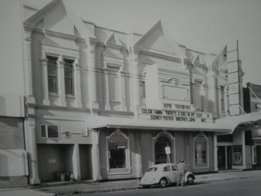
Article - ELSTERNWICK CLASSIC CINEMA
This file contains 4 items relating to the Elsternwick Classic Cinema: 1/1 original black and white photograph of the Elsternwick Classic Cinema, 9 Gordon Street Elsternwick. Date and photographer unknown. 2/ 2 photocopied photos of the Elsternwick Classic Theatre in its various stages of operation. One photo is of it as the Dorchester Dance Hall between 1938 and 1946 and the other is of the Classic Cinema in 1994. Photographers unknown. 3/National Trust of Australia (Victoria) Classification Report on Elsternwick Theatre with attached cover letter addressed to the Manager of the Planning Section, City of Glen Eira Council, from Ian Pausacker from the National Trust dated 04/10/2000. The report includes a statement of significance, history, description, context and floor plans of the theatre. 4/1 newspaper article written by Alex Njoo from the Caulfield/Port Philip Leader, 31/01/2012, congratulating the Tamir family on their conservation of the Elsternwick Classic Cinema. Includes a colour photo of the Tamirs, photographer unknown.elsternwick classic cinema, gordon street, elsternwick, dorchester dance hall, national trust of australia, national trust register, elsternwick theatre, pausacker ian, classic cinema, entertainment, cinemas, theatres, victorian style, elsternwick public hall, skating rink company limited, selwyn street, victorian permanent building society, community centres, films, shows and exhibitions, film projectors, amalgamate picture company ltd., richardson frank g., architecture, stairs, associated theatres limited, ballantyne and hared, balconies, architectural features, entrances, depression 1929-1939, astor, dancehalls, esquire theatre, prentice george, plottel joseph, architects, cowper murphy and associates, sharon cinema, tamir eddie, readings, free classical style, plans, business people, njoo alex, tamir family -
Federation University Historical Collection
Booklet - Report, Sturt Street Gardens, Ballarat, Victoria, Conservation and Landscape Management Plan, July 2007, 07/2007
The Sturt Street Gardens had its origins in the 1851 survey of Ballarat West by W.S. Urquhart. A generous reserve was allocated for the main streets of Ballarat, of which Sturt Street was the first. In the 1860s Sturt Street was planted with blue gums, with dual carriageway and central median Strip. Bandstands were soon erected.70 page report on the Ballarat Sturt Street gardens. The report includes an historical overview, Physical Analysis, Statement of Cultural Significance, and Consideration and Landscape Policies.queen alexandra bandstand, titanic memorial bandstand, sturt street, sturt street gardens, blue gum, statues, eight hour day memorial, boer war memorial, peter lalor statue, bluestone, bluestone guttering, william dunstan vc, time capsule, conservation management plan, landscape management plan -
 Ringwood and District Historical Society
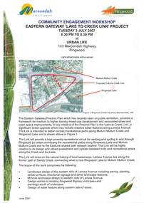
Document - Community Engagement Workshop, Eastern Gateway "Lake To Creek Link" Project - Ringwood, Victoria, 2007
2-page Maroondah City Council notice for workshop on Tuesday 3 July 2007 at Urban Life, 143 Maroondah Highway, Ringwood - light refreshments served.A key initiative of the Precinct Plan is the significant street upgrade which may include creative water features along Larissa Avenue to better connect recreational paths along Mullum Mullum Creek and Ringwood Lake. -
 Ringwood and District Historical Society
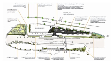
Document, Ringwood Transit City Public Domain and Landscape Guidelines (Railway Precinct, Ringwood, Victoria) 2012
4-page Urban Planning/Urban Design/Landscape Architecture guidelines for the design of street furniture, paving treatments and signage elements throughout the railway station precinct.Department of Transport. Aurecon & Grimshaw Architects. -
 Ringwood and District Historical Society
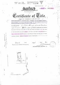
Document - Transfer of Land Act, Certificate of Title Vol 5127 Fol 1025238 including Ringwood Masonic Hall
Photocopied Certificate of Title Vol 5127 Fol 1025238 dated 9th March, 1926. Ernest Albert Milne (orchardist) and Jay Wilkins (builder) of Ringwood and Ernest Hugh Emmanuel Hann (carpenter) of East Ringwood are now proprietors as tenants in common in equal shares, Lot 30 on Plan of Subdivision No. 5577, part of Crown Allotment 19, Parish of Ringwood. Location map includes Aird Street, Pratt Street, Whitehorse Road. Subsequent Proprietors Transfers & Mortgate details include: Herman Pump and Frank Kenworthy of Ringwood and Albert Raymond of Collins Street Melbourne, trustees for the time being of the Loyal Ringwood Lodge No. 6724 of the MUIOOF Victoria Friendly Society - 26 June 1936, Holeproof Limited of 204 Sydney Road Brunswick, proprietor by transfer on 18th February, 1947, (*) Ringwood Masonic Hall Company Limited of 173 Whitehorse Road Ringwood, proprietor by transfer on 14th June, 1950, City Mutual Life Assurance Society Limited registered 1st March, 1965, ANZ Banking Group Limited, registered 10 June, 1981 & Discharged 3 June, 1982, Mayor Councillors and Citizens of the City of Ringwood registered as proprietors 6th July, 1982. (*During WWII, Holeproof had been renting the hall where they manufactured socks.) -
 Ringwood and District Historical Society
Book, Community Guide 2012 Maroondah City Council, Ringwood Victoria
Community information book issued by City of Maroondah for 2012 covering the facilities and activities of the Ringwood Council and other local organisations and associations. Includes contact details for Council services, community organisations and emergency services. Supplement - Maroondah In Focus newsletter Sept to Nov 2012 includes features on Ringwood Regional Aquatic and Leisure Centre construction, wiping out graffiti, Council's Youth Plan, Costco comes to town, Eastland transformation early works, Library Learning and Cultural Centre funding, Sherbrook Park plans, Pedestrian safety, -
 Ringwood and District Historical Society
Newspaper, Scrapbook Clipping, Library Collection, Ringwood, Victoria, `
``Newspaper clipping from The "Mail" , 31-10-95 P19 .Have your say on new green plan.Pupils from Ringwood and Croydon schools will have a say in how the local environment is developed.Maroondah City Council has asked schools for their opinions on developing a fresh environment plan for the municipality. -- Hundreds of volunteers were thanked for their loyal work last week during a cocktail party hosted by Martoondah City Council. Chief Commissioner Morton Browne thanked the "many committed and dedicated volunteers". A questionnaire will be distributed in Maroondah during the next fortnight to seek residents' opinions on future public open space areas, such as parklands and reserves.` -
 Ringwood and District Historical Society
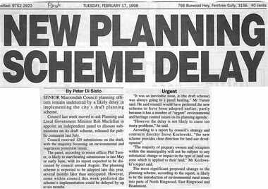
Newspaper, Scrapbook Clipping, Library Collection, Ringwood, Victoria, `
``Newspaper clipping from the "Post", Tuesday February 17, 1998. NEW PLANNING SCHEME DELAY. By Peter Di SistoSenior Maroondah Council planning officers remain undeterred.by a likely delay in implementing the city's draft planning scheme. Council last week moved to ask Planning and Local Government Minister Rob Maclellan to appoint an independent panel to discuss submissions on its draft scheme, released for public comment last July. `