Showing 11096 items matching "society records"
-
 Bendigo Historical Society Inc.
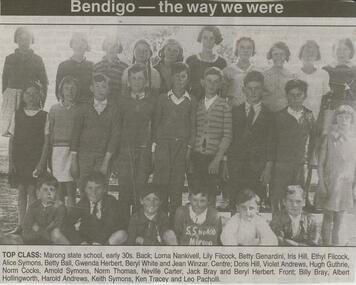
Newspaper - JENNY FOLEY COLLECTION: TOP CLASS
... Society Inc. History House 11 Mackenzie Street Bendigo goldfields Marong Primary School No. 400 began as a National School in 1859 and was designated a Common School in 1862 when attendance was recorded as 42 students. ...Marong Primary School No. 400 began as a National School in 1859 and was designated a Common School in 1862 when attendance was recorded as 42 students. In 1970 it was redesignated as Marong Primary School and is still in operation in 2025.Bendigo Advertiser '' The way we were'' from Tuesday, March 16, 2004. Top class: Marong State School, early 30s. Back Lorna Nankivell, Lily Filcock, Betty Genardini, Iris Hill, Ethyl Filcock, Alice Symons, Betty Ball, Gwenda Herbert, Beryl White and Jean Winzar. Centre: Doris Hill, Violet Andrews, Hugh Guthrie, Norm Cocks, Arnold Symons, Norm Thomas, Neville Carter, Jack Bray and Beryl Herbert. Front: Billy Bray, Albert Hollingworth, Harold, Andrews, Keith Symons, Ken Tracey and Leo Pacholli. The clip is in a folder.newspaper, bendigo advertiser, the way we were -
 Bendigo Historical Society Inc.
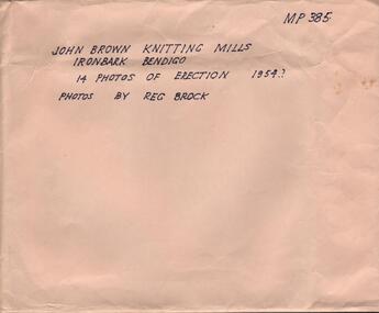
Photograph - HANRO COLLECTION: PHOTOGRAPHS OF THE ERECTION OF JOHN BROWN KNITTING MILLS, 1954
... Society Inc. History House 11 Mackenzie Street Bendigo goldfields John Brown Industries became a listed company in 1951 and acquired Star Hosiery Mills factory and its Bendigo offshoot. In 1955 they purchased a 4 acre site at Ironbark to build a new mill. This was completed in a record ...John Brown Industries became a listed company in 1951 and acquired Star Hosiery Mills factory and its Bendigo offshoot. In 1955 they purchased a 4 acre site at Ironbark to build a new mill. This was completed in a record 19and a half weeks and the mill was handed over in Sept. 1956.Photographs of the Erection of John Brown Knitting Mills: A brown envelope which had hand printed writing in black ink. On the right hand top is *MP385*. In the middle *John Brown Knitting Mills Ironbark Bendigo. 14 Photos of Erection 1954? Photos by Reg Brock*. Attached to the envelope is a torn piece so paper which has been hand written in blue ink *John Brown & Welmar* Knitwear Socks & Dress wear The Finest in the Land. Made on the site of Bendigo's Richest Gold Mine, *The Little 180*. Inside the envelope is a collection of black and white photos of the erection of the John Brown Knitting Mills on Marong Road in Ironbark Bendigo. 14 Photos in total showing various views of the construction site. Workmen on the site laying bricks, constructing the steel building and trucks delivering steel etc. A crane truck with *General Carriers Bendigo* printed on the side door. On the back of each photo is *MP385*. The Circular stamp in blue ink of the Royal Historical Society of Victoria Bendigo Branch and a cream photographers label with a blue band top and bottom with *Reg. V. Brock of Bendigo in the bands. In the centre of the label in blue print is *No.... B1098. pos.... Additional copies may be obtained at any time by quoting this number. Box 116A.Reg. V. Brock of Bendigo.photograph, building, john brown, john brown knitting mills -
 Bendigo Historical Society Inc.
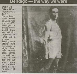
Newspaper - JENNY FOLEY COLLECTION: WORLD CHAMPION
... Society Inc. History House 11 Mackenzie Street Bendigo goldfields John (Jack ) Donaldson was born in Raywood in 1886 but he was raised in Inglewood. A natural runner he held 6 world records ...John (Jack ) Donaldson was born in Raywood in 1886 but he was raised in Inglewood. A natural runner he held 6 world records in sprint events from 100 yards to 400 yards. He came second in his first appearance at the Stawell Gift in 1906. He was nicknamed "The Blue Streak" and raced all over the world in official professional races, exhibitions and challenge events. He moved to New York in 1919 where he married Ethel Auer in 1925. He ran a gymnasium in NY but committed suicide in 1933. He is remembered each year with the running of the "Jack Donaldson 200m. handicap " race at the Stawell Gift meeting.Bendigo Advertiser ''the way we were'' from Friday, January 2, 2004. World champion: Inglewood's John Donaldson, better known as Jack, was born in 1886. Although he lacked professional training, Jack skyrocketed to fame as a sprinter. Starting at the Stawell gift, his stride of eight feet, four inches, soon earned him world records for the 150 and 300 yard races; records which stood for nearly 100 years. He died in 1933 at the age of 49. The clip is in a folder.newspaper, bendigo advertiser, the way we were -
 Bendigo Historical Society Inc.
Book - STRAUCH COLLECTION: WHROO CEMETERY VICTORIA
... Society Inc. History House 11 Mackenzie Street Bendigo goldfields Although the first recorded burial at Whroo (7 km south of Rushworth) was in 1858, it is believed earlier unrecorded burial took place. ...Although the first recorded burial at Whroo (7 km south of Rushworth) was in 1858, it is believed earlier unrecorded burial took place. The official cemetery was established in 1860 and contains approx. 400 burials although many are unmarked. There is also a Chinese section as in 1863 17% of the population was Chinese in 1863.Red Spring binder containing list of interments in Whroo Cemetery with maps & illustrations.James & Nicola Thomsonplace, cemetery, whroo, victoria-whroo-rusthworth-history-cemetery -
 Bendigo Historical Society Inc.
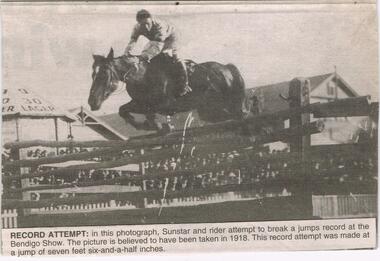
Newspaper - JENNY FOLEY COLLECTION: RECORD ATTEMPT
... Society Inc. History House 11 Mackenzie Street Bendigo goldfields BHS Collection NEWSPAPER Bendigo advertiser the way we were Bendigo Advertiser '' The way we were'' from Monday, October 21, 2002. Record ...BHS CollectionBendigo Advertiser '' The way we were'' from Monday, October 21, 2002. Record attempt: in this photograph, Sunstar and rider attempt to break a jumps record at the Bendigo Show. The picture is believed to have been taken in 1918. This record attempt was made at a jump of seven feet six-and-a-half inches. The clip is in a folder.newspaper, bendigo advertiser, the way we were -
 Bendigo Historical Society Inc.
Document - LA TROBE UNIVERSITY BENDIGO COLLECTION: THE VALUE OF HISTORY 2
... Society Inc. History House 11 Mackenzie Street Bendigo goldfields BHS Collection BENDIGO Education bendigo teachers' college La Trobe University Bendigo Collection collection Bendigo Bendigo Teachers' College teaching teachers history History - Study and Teaching Mr. L.J. Pryor male individual person Education resource Centre curriculum A brown folder titled "The Value of History 2". A teaching plan with which to teach the contribution of history to students. From the files of Mr. L.J. Pryor former Principal of Bendigo Teachers' College. Donated to Education resource Centre for archival use in 1992. Also included is a small booklet titled "Record ...BHS CollectionA brown folder titled "The Value of History 2". A teaching plan with which to teach the contribution of history to students. From the files of Mr. L.J. Pryor former Principal of Bendigo Teachers' College. Donated to Education resource Centre for archival use in 1992. Also included is a small booklet titled "Record of Lessons" with the name Fred East Past Lecturer, Bendigo Teachers' College.bendigo, education, bendigo teachers' college, la trobe university bendigo collection, collection, bendigo, bendigo teachers' college, teaching, teachers, history, history - study and teaching, mr. l.j. pryor, male, individual, person, education resource centre, curriculum -
 Bendigo Historical Society Inc.
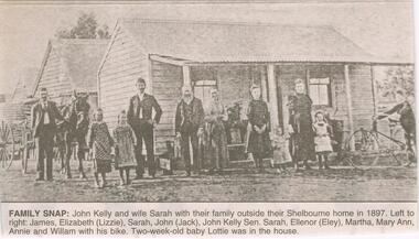
Newspaper - JENNY FOLEY COLLECTION: FAMILY SNAP
... Society Inc. History House 11 Mackenzie Street Bendigo goldfields John Kelly (1859-1941) was born at Lockwood, the son of Patrick and Ann Kelly. In 1873 he married Sarah Ann Nievandt and they had 11 children. John Andrew (Jack) 1874-1952; James 1877-1878; James (1878- ); Mary Ann (1880- ); Eleanor Harriet (1883-1982); William Patrick (1885-1965); Elizabeth Margaret (1887- ); Sarah Louise (1889- ); Annie (1892-1902); Lottie (1897- ) . Eleanor married George James Lakey in 1904. No birth record ...John Kelly (1859-1941) was born at Lockwood, the son of Patrick and Ann Kelly. In 1873 he married Sarah Ann Nievandt and they had 11 children. John Andrew (Jack) 1874-1952; James 1877-1878; James (1878- ); Mary Ann (1880- ); Eleanor Harriet (1883-1982); William Patrick (1885-1965); Elizabeth Margaret (1887- ); Sarah Louise (1889- ); Annie (1892-1902); Lottie (1897- ) . Eleanor married George James Lakey in 1904. No birth record found for Martha. This photo can be dated to 1897/98Bendigo Advertiser ''The way we were'' from 2003. Family snap: John Kelly and wife Sarah with their family outside their Shelbourne home in 1897. Left to right: James, Elizabeth (Lizzie), Sarah, John (Jack), John Kelly Sen., Sarah, Ellenor (Eley), Martha, Mary Ann, Annie and William with his bike. Two-week old baby Lottie was in the house. The clip is in a folder.newspaper, bendigo advertiser, the way we were -
 Bendigo Historical Society Inc.
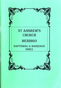
Book - STRAUCH COLLECTION: ST ANDREWS CHURCH BENDIGO BAPTISMAL & MARRIAGE INDEX
... Society Inc. History House 11 Mackenzie Street Bendigo goldfields BHS Collection CHURCH History st andrews Bendigo-History-Church-St Andrews-Baptismn-Marriage St Andrew's Church Bendigo Baptismal & Marriage Index of all available records up to 1925 published by Bendigo Area, Australian Institute of Genealogical Studies, 90 pages in a green soft cover. ...BHS CollectionSt Andrew's Church Bendigo Baptismal & Marriage Index of all available records up to 1925 published by Bendigo Area, Australian Institute of Genealogical Studies, 90 pages in a green soft cover.church, history, st andrews, bendigo-history-church-st andrews-baptismn-marriage -
 Bendigo Historical Society Inc.
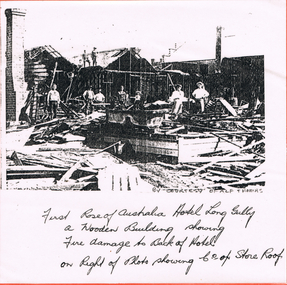
Newspaper - LONG GULLY HISTORY GROUP COLLECTION: FIRST ROSE OF AUSTRALIA HOTEL
... Society Inc. History House 11 Mackenzie Street Bendigo goldfields Earliest newspaper record show that the Rose of Australia Hotel was operating by October 1855. ...Earliest newspaper record show that the Rose of Australia Hotel was operating by October 1855. The fire that burnt the hotel down occurred 29th November 1907.Photocopy of the First Rose of Australia Hotel, Long Gully. Photo shows fire damage to the back of the hotel. It was a wooden building. On the left is the square chimney. The foreground is scattered timbers. There are six people and a child standing amongst the rubble. In the background is the damaged part of the building which is still standing. Two men are standing on the roof. On the right of photo is the Co of Store roof and a chimney. Written below the photo is: By courtesy of Alf Thomas and First Rose of Australia Hotel Long Gully. A Wooden Building showing Fire damage to Back of Hotel on Right of Photo showing Co of Store Roof. Photo is mounted on orange card which is mounted on fawn card and laminated.bendigo, history, long gully history group, the long gully history group - first rose of australia hotel, alf thomas -
 Bendigo Historical Society Inc.
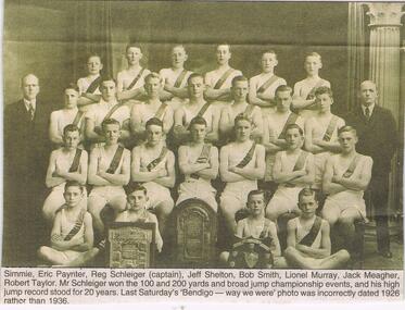
Newspaper - JENNY FOLEY COLLECTION: SCHOOL SPORTS
... Society Inc. History House 11 Mackenzie Street Bendigo goldfields BHS Collection NEWSPAPER Bendigo advertiser the way we were Bendigo Advertiser ''The way we were'' from 2002. School sports: the Bendigo Senior Secondary College athletes of 'Z' team in 1941. ? Kent, G. Salathiel, Cardwell McQuillan (teacher), West ?, Ron Warren, Gavin Semmens, Alf Morris, Mr. J. Muntz (teacher), Bill Simmie, Eric Paynter, Reg Schleiger (captain), Jeff Shelton, Bob Smith, Lionel Murray, Jack Meagher, Robert Taylor. Mr. Schleiger won the 100 and 200 yards and broad jump championship events, and his high jump record ...BHS CollectionBendigo Advertiser ''The way we were'' from 2002. School sports: the Bendigo Senior Secondary College athletes of 'Z' team in 1941. ? Kent, G. Salathiel, Cardwell McQuillan (teacher), West ?, Ron Warren, Gavin Semmens, Alf Morris, Mr. J. Muntz (teacher), Bill Simmie, Eric Paynter, Reg Schleiger (captain), Jeff Shelton, Bob Smith, Lionel Murray, Jack Meagher, Robert Taylor. Mr. Schleiger won the 100 and 200 yards and broad jump championship events, and his high jump record stood for 20 years. Last Saturday 's Bendigo the way we were photo was incorrectly dated 1926 rather than 1936. The clip is in a folder.newspaper, bendigo advertiser, the way we were -
 Bendigo Historical Society Inc.
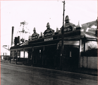
Photograph - LONG GULLY HISTORY GROUP COLLECTION; ROSE OF AUSTRALIA HOTEL
... Society Inc. History House 11 Mackenzie Street Bendigo goldfields Earliest newspaper record show that the Rose of Australia Hotel was operating by October 1855. ...Earliest newspaper record show that the Rose of Australia Hotel was operating by October 1855. The fire that burnt the wooden hotel down occurred 29th November 1907. It was then rebuilt in brick.Black and white photo of the Rose of Australia Hotel. It has the name painted across three decorative pediments at roof level. The licensee's name, H. Paynting, is painted beneath the centre pediment. The building is brick with white bricks at the corners and around the windows and doors. It has a bull-nosed veranda with iron lace and decorated veranda posts. The photo is quite dark beneath the veranda. There is a house next door and behind that is a poppet legs, a tall chimney, what looks like two smaller chimneys and a mine building. It is situated on Eaglehawk Road. The photo is mounted on an orange card which is mounted on a tan card and laminated.bendigo, history, long gully history group, the long gully history group - rose of australia hotel, h paynting -
 Bendigo Historical Society Inc.
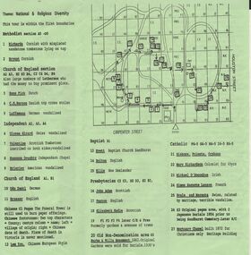
Document - BENDIGO CEMETERIES COLLECTION: SELF GUIDED TOUR NO. 4 DOCUMENT
... Society Inc. History House 11 Mackenzie Street Bendigo goldfields BHS Collection BENDIGO Cemetery bendigo cemetery tour Friends of the Bendigo Cemeteries Inc 1997 Green trifold document: Self Guided Tour No. 4 of the Bendigo Cemetery, Friends of the Bendigo Cemeteries 1997. Map of Bendigo Cemetery with numbered grave sites. Theme : National and religious diversity. Text on back describes how early colonists arrived with different religions, languages, social habits etc Sandhurst Cemetery Register recorded ...BHS CollectionGreen trifold document: Self Guided Tour No. 4 of the Bendigo Cemetery, Friends of the Bendigo Cemeteries 1997. Map of Bendigo Cemetery with numbered grave sites. Theme : National and religious diversity. Text on back describes how early colonists arrived with different religions, languages, social habits etc Sandhurst Cemetery Register recorded denomination not nationality, but noted if the dead person was coloured.Friends of the Bendigo Cemeteries Inc 1997bendigo, cemetery, bendigo cemetery tour -
 Bendigo Historical Society Inc.
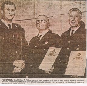
Newspaper - JENNY FOLEY COLLECTION: DEDICATION
... Society Inc. History House 11 Mackenzie Street Bendigo goldfields Golden Square Fire Brigade was established in High Street, Golden Square, in 1881. A New station building was opened in 2025 in Speciman Gully Road. NEWSPAPER Bendigo advertiser the way we were Bendigo Advertiser '' the way we were'' from 2002. Dedication: Chief Officer A. Pitfield presents long service certificates to Jack Harper and Bob McGann. The two Golden Square firemen have 84 years' service between them and one of the finest service records ...Golden Square Fire Brigade was established in High Street, Golden Square, in 1881. A New station building was opened in 2025 in Speciman Gully Road.Bendigo Advertiser '' the way we were'' from 2002. Dedication: Chief Officer A. Pitfield presents long service certificates to Jack Harper and Bob McGann. The two Golden Square firemen have 84 years' service between them and one of the finest service records in the brigade. Date unknown. The clip is in a folder.newspaper, bendigo advertiser, the way we were -
 Bendigo Historical Society Inc.
Document - BENDIGO HOSPITAL CONTRIBUTORY FUND CARD, 1935
... Society Inc. History House 11 Mackenzie Street Bendigo goldfields BENDIGO Institutions hospitals Bendigo Hospital contributory fund card. M. E. Bush Bendigo Hospital contributory fund card: For Miss M.E. Bush. Blue in colour with no. 6114. In black print is a circular logo with a man holding a bag and the words *As Ye Sow* and Contributory Fund. Around the circle the words 'Bendigo & Northern District. For Public & Private Hospitals. Name: written in blue ink is 'Miss M.E. Bush, the address 251 View Street. Bendigo. Head Office, (Secretary), Base Hospital Grounds Entrance. Bendigo Phone 1200. Also Castlemaine information. Inside the Card records ...Bendigo Hospital contributory fund card: For Miss M.E. Bush. Blue in colour with no. 6114. In black print is a circular logo with a man holding a bag and the words *As Ye Sow* and Contributory Fund. Around the circle the words 'Bendigo & Northern District. For Public & Private Hospitals. Name: written in blue ink is 'Miss M.E. Bush, the address 251 View Street. Bendigo. Head Office, (Secretary), Base Hospital Grounds Entrance. Bendigo Phone 1200. Also Castlemaine information. Inside the Card records payments to the fund, Rules and Benefits. Commencement date of the fund contribution is 11th May 1935. Box 625bendigo, institutions, hospitals, bendigo hospital contributory fund card. m. e. bush -
 Bendigo Historical Society Inc.
Slide - DIGGERS & MINING. DIGGERS AND MINERS, 1850s
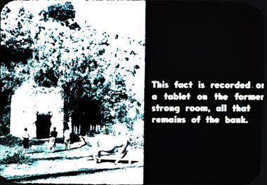
... Society Inc. History House 11 Mackenzie Street Bendigo goldfields EDUCATION Tertiary goldfields hanimount Diggers & Mining. Diggers and Miners. This fact is recorded ...Diggers & Mining. Diggers and Miners. This fact is recorded on a tablet on the former strong room, all that remains of the bank. Picture shows the strong room half surrounded by vegetation with a cow and some people in the front. Markings: 57 994.5 WAL. Used as a teaching aid.hanimounteducation, tertiary, goldfields -
 Bendigo Historical Society Inc.
Document - BENDIGO EASTER FAIR COLLECTION: LETTER RE WILLIAM O'CONNOR, 3rd April, 1998
... Society Inc. History House 11 Mackenzie Street Bendigo goldfields BENDIGO Bendigo easter fair william o'connor 5 page letter to Bendigo Easter Fair Committee from Andrea Phipps, 37 Echuca Road, Rochester, 3 April, 1998, re Andrea's great grandfather, William O'Connor who was attired as the local Chinese Emperor, alias 'the Great Oh Con Ah' who led the procession the the 1880 Fair. A family tree is outlined briefly. Enclosed with letter are 3 pages transcribed from the Bendigo Advertiser, telling the story of the 1880 Easter Fair. William O'Connor came to Sandhurst with the gold rush, first record ...5 page letter to Bendigo Easter Fair Committee from Andrea Phipps, 37 Echuca Road, Rochester, 3 April, 1998, re Andrea's great grandfather, William O'Connor who was attired as the local Chinese Emperor, alias 'the Great Oh Con Ah' who led the procession the the 1880 Fair. A family tree is outlined briefly. Enclosed with letter are 3 pages transcribed from the Bendigo Advertiser, telling the story of the 1880 Easter Fair. William O'Connor came to Sandhurst with the gold rush, first record of him buying land in 1854. A Blacksmith and wheelwright, owned the 'Sydney Forge' with his sister and husband, Ellen and John Brewster.bendigo, bendigo easter fair, william o'connor -
 Bendigo Historical Society Inc.
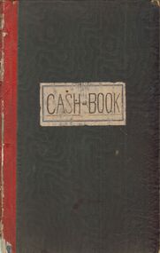
Book - H.A. & S.R. WILKINSON COLLECTION: CASH BOOK
... Society Inc. History House 11 Mackenzie Street Bendigo goldfields BHS Collection ORGANIZATION Business h.a. & s.r wilkinson real estate Yellow label 594. Green business Cash Book. The book has 189 pages and covers the period from March 1934 till October 1938 . For each months all the cash transaction are recorded ...BHS CollectionGreen business Cash Book. The book has 189 pages and covers the period from March 1934 till October 1938 . For each months all the cash transaction are recorded and reconciled with trust A/c.organization, business, h.a. & s.r wilkinson real estate, yellow label 594. -
 Bendigo Historical Society Inc.
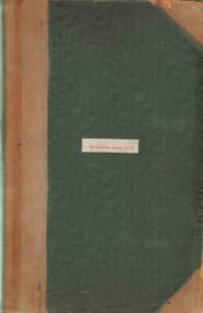
Book - H.A & S.R. WILKINSON COLLECTION: CASH BOOK
... Society Inc. History House 11 Mackenzie Street Bendigo goldfields BHS Collection ORGANIZATION Business h.a. & s.r wilkinson real estate Yellow label 594. Green business Cash Book. The book has 191 pages and covers the period from November 1955 till October 1966. For each months all the cash transaction are recorded ...BHS CollectionGreen business Cash Book. The book has 191 pages and covers the period from November 1955 till October 1966. For each months all the cash transaction are recorded and reconciled with trust A/c.organization, business, h.a. & s.r wilkinson real estate, yellow label 594. -
 Bendigo Historical Society Inc.
Document - DOUGLAS FAMILY TREE 1843 - 1981, 1843 - 1981
... Society Inc. History House 11 Mackenzie Street Bendigo goldfields James Crawford Douglas was born in Ireland in 1842. He came to Australia in 1864 and married Mary Michael (1849-1921) in 1868. They settled at View Hill farm in Woodstock West where they had the following family:- BENDIGO History pioneers Family tree records descendants of James and Mary Douglas. ...James Crawford Douglas was born in Ireland in 1842. He came to Australia in 1864 and married Mary Michael (1849-1921) in 1868. They settled at View Hill farm in Woodstock West where they had the following family:- Family tree records descendants of James and Mary Douglas. James was the original selector of View Hill Farm which remains in Douglas ownership. Refer to book 5086 in Library Box 5 'Douglas: A Family History 1845 - 1981'bendigo, history, pioneers -
 Bendigo Historical Society Inc.
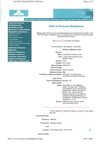
Document - RED CROSS RECORD OF MALDWYN LESLIE WILLIAMS, 1914 - 1918
... Society Inc. History House 11 Mackenzie Street Bendigo goldfields BHS Collection PERSON Individual m.l. williams Williams Maldwyn Leslie. Medical Practitioners. Bendigo Base Hospital. World War 1. Bartlett Bros. Red Cross Record ...BHS CollectionRed Cross Record Maldwyn Leslie Williams, Lt. Col. MBBS, who died of wounds received in France, March, 3rd. 1917.' Three sheetsperson, individual, m.l. williams, williams, maldwyn leslie. medical practitioners. bendigo base hospital. world war 1. bartlett bros. -
 Bendigo Historical Society Inc.
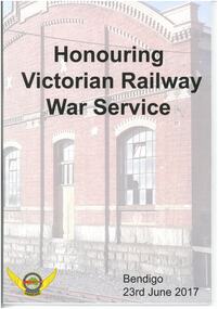
Magazine - HONOURING VICTORIAN RAILWAY WAR SERVICE - BENDIGO 23 JUNE 2017
... Society Inc. History House 11 Mackenzie Street Bendigo goldfields Sandhurst Railway station opened in October 1862 and was renamed Bendigo in 1891. The current station was built in 1965 and has had extensive refurbishments since then, including in 1984 and 1988. Rail Tram ande Bus Union - Locomotive Division Victoria Magazine publication with coloured photograph of Bendigo Railway Station on front and back cover. Contains 50 pages of biographies of those locomotive drivers who served in World War I. Also contains photographs of people, war service records ...Sandhurst Railway station opened in October 1862 and was renamed Bendigo in 1891. The current station was built in 1965 and has had extensive refurbishments since then, including in 1984 and 1988.Magazine publication with coloured photograph of Bendigo Railway Station on front and back cover. Contains 50 pages of biographies of those locomotive drivers who served in World War I. Also contains photographs of people, war service records, newspaper articles and buildings.Rail Tram ande Bus Union - Locomotive Division Victoria -
 Bendigo Historical Society Inc.
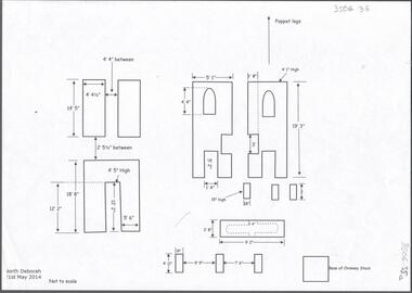
Document - CENTRAL DEBORAH GOLD MINE: NORTH DEBORAH GOLD MINE
... Society Inc. History House 11 Mackenzie Street Bendigo goldfields BHS Collection BENDIGO Mining central deborah gold mine Seven page document with diagrams of the remnant footings of the North Deborah Gold Mine, the South Deborah Gold Mine, Deborah Extended, Deborah Consolidated, Deborah United Deborah Associated. Measurements of footings recorded ...BHS CollectionSeven page document with diagrams of the remnant footings of the North Deborah Gold Mine, the South Deborah Gold Mine, Deborah Extended, Deborah Consolidated, Deborah United Deborah Associated. Measurements of footings recorded but sites are not to scale. Researched and drawn by Philip Wilkin and Kay MacGregor, 2014.bendigo, mining, central deborah gold mine -
 Bendigo Historical Society Inc.
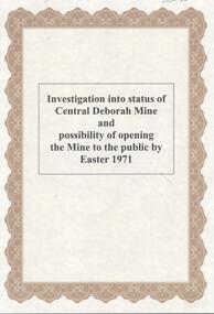
Document - CENTRAL DEBORAH GOLD MINE: INVESTIGATION INTO STATUS OF OPENING EASTER 1971
... Society Inc. History House 11 Mackenzie Street Bendigo goldfields BHS Collection BENDIGO Mining central deborah gold mine 4 page document. Record ...BHS Collection4 page document. Record of sub-committee appointed to investigate status of Central Deborah Mine and possibility of opening the mine to the public by Easter 1971. Present at meeting: J. Watts, A. Richardson, H. Biggs, C. Schumack, J. Bright, Cr. A. Roy and J. Cohn.bendigo, mining, central deborah gold mine -
 Bendigo Historical Society Inc.
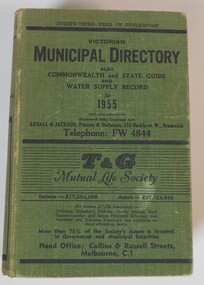
Book - BOOK: VICTORIAN MUNICIPAL DIRECTORY ALSO COMMONWEALTH AND STATE GUIDE AND WATER SUPPLY RECORD FOR 1955, 1955
... Society Inc. History House 11 Mackenzie Street Bendigo goldfields BHS Collection GOVERNMENT Published by Arnall and Jackson Hard cover book with a woven green coloured cover, with black printing on front and spine. Contains 1071 pages of information concerning Federal, State and Local Government and their departments and Water Supply Authorities for 1955. Includes a section on City of Bendigo and surrounding local shires. Book BOOK: VICTORIAN MUNICIPAL DIRECTORY ALSO COMMONWEALTH AND STATE GUIDE AND WATER SUPPLY RECORD ...BHS CollectionHard cover book with a woven green coloured cover, with black printing on front and spine. Contains 1071 pages of information concerning Federal, State and Local Government and their departments and Water Supply Authorities for 1955. Includes a section on City of Bendigo and surrounding local shires.Published by Arnall and Jacksongovernment -
 Bendigo Historical Society Inc.
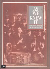
Book - BOOK: AS WE KNEW IT - REFLECTIONS FROM THE ANNE CAUDLE CENTRE, 1992
... Society Inc. History House 11 Mackenzie Street Bendigo goldfields BHS Collection HISTORY Oral history Kevin Weeks. Ted Drayton Doris Ross Mary Fittis Ella O'Halloran Reg Collis Bill Chapple John Newman John Wilson Margaret Landers Alf Swift Arthur Pearce Sulvia Harvey Edith Ryan Sylvia Lovell Julie Marshall Softcover book with photograph on front cover of the Bendigo Citizens Band and photograph on back cover of the 50th anniversary Red Cross Meeting held in Bendigo c1900. Contains 83 pages which record ...BHS CollectionSoftcover book with photograph on front cover of the Bendigo Citizens Band and photograph on back cover of the 50th anniversary Red Cross Meeting held in Bendigo c1900. Contains 83 pages which record 15 oral histories of residents of the Anne Caudle Centre Bendigo in 1992. Also contains black and white photographs of people relative to the oral histories.Julie Marshallhistory, oral history, kevin weeks. ted drayton, doris ross, mary fittis, ella o'halloran, reg collis, bill chapple, john newman, john wilson, margaret landers, alf swift, arthur pearce, sulvia harvey, edith ryan, sylvia lovell -
 Bendigo Historical Society Inc.
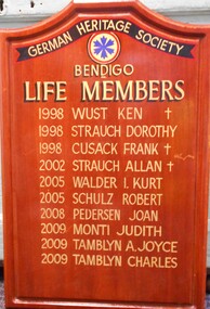
Administrative record - GERMAN HERITAGE SOCIETY COLLECTION: LIFE MEMBERS HONOUR BOARD, 1998 - 2019
... History House 11 Mackenzie Street Bendigo goldfields BHS Collection BENDIGO Clubs german heritage society German Heritage Society Collection Wooden Honour Board for German Heritage Society Bendigo Life Members 1998 Ken Wust, Dorothy Strauch, Frank Cusack 2002 Allan Strauch 2005 I. Kurt Walder, Robert Schulz 2008 Joan Pederson 2009 Judith Monti, A. Joyce Tamblyn, Charles Tamblyn Administrative record ...BHS CollectionWooden Honour Board for German Heritage Society Bendigo Life Members 1998 Ken Wust, Dorothy Strauch, Frank Cusack 2002 Allan Strauch 2005 I. Kurt Walder, Robert Schulz 2008 Joan Pederson 2009 Judith Monti, A. Joyce Tamblyn, Charles Tamblynbendigo, clubs, german heritage society, german heritage society collection -
 Bendigo Historical Society Inc.
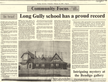
Document - LONG GULLY HISTORY GROUP COLLECTION: LONG GULLY SCHOOL HAS A PROUD RECORD
... Society Inc. History House 11 Mackenzie Street Bendigo goldfields Long Gully Primary School (No. 2120) was designed by Henry Bastow and opened in 1879. It was built on the site of the former Long Gully Common School (no.372) that had closed in 1867. The school closed in 1992 and is now the head office of CVGT. The building is Heritage listed. BENDIGO History long gully history group The Long Gully History Group - Long Gully School has a proud record ...Long Gully Primary School (No. 2120) was designed by Henry Bastow and opened in 1879. It was built on the site of the former Long Gully Common School (no.372) that had closed in 1867. The school closed in 1992 and is now the head office of CVGT. The building is Heritage listed.Copy of a Bendigo Advertiser article titled Community Focus with Maurie McDonald. This article is titled Long Gully school (No 2120) has a proud record. The school was having a reunion on April 1. The article mentions history of the school which was opened in 1879. The Advertiser is dated February 14, 1990. Written in the top right corner is 120 years.bendigo, history, long gully history group, the long gully history group - long gully school has a proud record, bendigo advertiser 14/2/1990, maurie mcdonald, long gully primary school no 2120, alan crossley, colin buzza, long gully post office, 1872 education act, california gully no 123, rae's ironbark school no 323, violet st no 877, long gully mechanics' institute, shamrock hotel sandhurst, wesleyan school, german school, mr blaney's school, sandhurst board of advice, the church of england reserve, crawford bros, bath hotel sandhurst, ironbark hill, manchester arms -
 Bendigo Historical Society Inc.
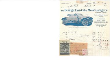
Financial record - BENDIGO TAXI-CAB & MOTOR GARAGE INVOICE
... Society Inc. History House 11 Mackenzie Street Bendigo goldfields Bendigo Taxi-Cab & Motor Garage Co. Invoice to Mr W Beebe for goods and repairs. Located at Corner of High Street and Short Street. Dated December 1 1917. Receiopt for payment attached to the invoice. Paid on January 30 1918. Financial record ...Bendigo Taxi-Cab & Motor Garage Co. Invoice to Mr W Beebe for goods and repairs. Located at Corner of High Street and Short Street. Dated December 1 1917. Receiopt for payment attached to the invoice. Paid on January 30 1918. -
 Bendigo Historical Society Inc.
Book - SCRAPBOOK WALLACE & BRAMLEY
... Society Inc. History House 11 Mackenzie Street Bendigo goldfields Wallace & Bramley Large scrapbook with newspaper cuttings from Wallace & Bramley, Stock and Station Agents of Bull Street Bendigo. The scrapbook contains newspaper clippings of advertisements for sales and auctions by Wallace & Bramley covering the period from November 1922 until December 1960. Each entry has the date and the newspaper or journal where it appeared recorded ...Large scrapbook with newspaper cuttings from Wallace & Bramley, Stock and Station Agents of Bull Street Bendigo. The scrapbook contains newspaper clippings of advertisements for sales and auctions by Wallace & Bramley covering the period from November 1922 until December 1960. Each entry has the date and the newspaper or journal where it appeared recorded in ink. Entries are from Bendigo and surrounding districts including Leitchville, Dingee, Pyramid Hill, Mitiamo and many others.Wallace & Bramley -
 Bendigo Historical Society Inc.
Book - A PHOTOGRAPHIC RECORD OF THE PIONEERS OF BENDIGO
... Society Inc. History House 11 Mackenzie Street Bendigo goldfields BENDIGO History pioneers Rita Hull A Photographic Record of the Pioneers of Bendigo compiled by Rita Hull, 47 pages in a spring bound binder with lemon frontis piece with photographs, some colour. ...A Photographic Record of the Pioneers of Bendigo compiled by Rita Hull, 47 pages in a spring bound binder with lemon frontis piece with photographs, some colour.Rita Hullbendigo, history, pioneers